Black Sturgeon River Park Management Plan (2003 – Amended 2019)
This document provides direction for the protection and management of Black Sturgeon River Provincial Park.
Amendment approval statement
August 28, 2019
Dear Sir or Madam:
I am pleased to approve this amendment to the management statement for Black Sturgeon River Provincial Park. The amendment provides revised direction in the management statement for the issuance of commercial tenure and conditions of any disposition, including requirements under the Provincial Parks and Conservation Reserves Act, 2006 and approval through an environmental assessment process.
I would like to express my appreciation to those who participated in the planning process.
Sincerely,
Jason Travers, Director
Ontario Parks
Approval statement
July 2003
Dear Sir/ Madam:
I am pleased to approve the Black Sturgeon River Provincial Park Management Plan as the official policy for the protection and management of Black Sturgeon River Provincial Park. The plan reflects the Ministry of Natural Resources' and Ontario Parks' intent to protect the natural and cultural features of Black Sturgeon River Provincial Park, while maintaining and developing high quality opportunities for outdoor recreation and heritage appreciation for the residents of Ontario and visitors to the province.
The Black Sturgeon River Provincial Park is located within the Lake Nipigon Basin Signature site, one of 9 such areas featured in the Ontario’s Living Legacy Land Use Strategy (1999). Signature Sites are identified for their range of natural and recreational values and their potential to contribute to future recration and tourism.
This management plan has been developed under the general direction of the Lake Nipigon Basin Signature Site Ecological Land Use and Resource Management Strategy, which provides the overall context for land use and resource management activities in the Basin.
The plan includes a prioritized implementation strategy and summarizes the public consultation that occurred as part of the planning process.
The park management plan will be used to guide the management of this park. It may be reviewed to address changing issues or conditions. A review will be held as required.
I wish to extend my sincere thanks to all those who participated in the public consultation process.
Yours truly,
Adair Ireland-Smith
Managing Director
Ontario Parks
Statement of Environmental Values and the Environmental Bill of Rights
In accordance with the provisions of the Environmental Bill of Rights, the Ministry of Natural Resources prepared a Statement of Environmental Values. It describes how the purposes of the Environmental Bill of Rights are to be considered whenever decisions are to be made which might significantly affect the environment. This includes decisions made as a result of the park management planning process.
The primary purpose of the Environmental Bill of Rights is "to protect, conserve and wherever possible, restore the integrity of the environment." From the Ministry’s perspective, that broad statement of purpose translates into four objectives in its Statement of Environmental Values:
- To ensure the long-term health of the ecosystems by protecting and conserving our valuable soil, aquatic resources, forest and wildlife resources as well as their biological foundations;
- To ensure the continuing availability of natural resources for the long-term benefit of the people of Ontario;
- To protect natural heritage and biological features of provincial significance; and,
- To protect human life, the resource base and the physical property from the threats of forest fires, floods and erosion.
The Ministry’s Statement of Environmental Values has been considered in the development of this park management plan for Black Sturgeon River Provincial Park.
Figure 13: Regional Setting
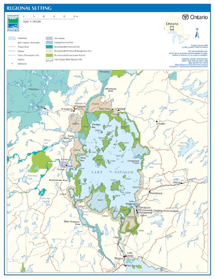
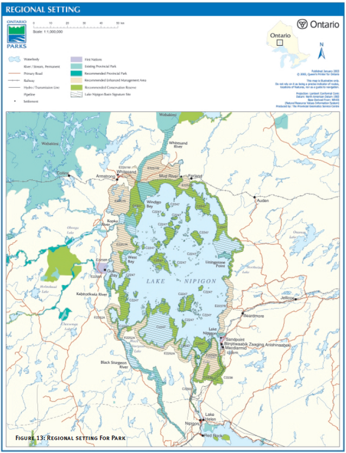
1.0 Introduction
Black Sturgeon River Provincial Park (P2250) was recommended as part of Ontario’s Living Legacy Land Use Strategy (OMNR 1999) that guides the planning and management of Crown lands in central and portions of northern Ontario. Under this initiative, 378 new protected areas were identified. Black Sturgeon River Provincial Park is part of this significant expansion of Ontario’s protected areas system.
The park is a component of the Lake Nipigon Basin Signature Site. The planning process for the Lake Nipigon Basin Signature Site is a complex initiative. A single process is being applied to the signature site, which contains a number of areas with different land use designations. These areas all share common planning stages and timelines, thereby facilitating the concurrent planning process. The areas included within the Lake Nipigon Basin also share common geographic themes, recreation uses and resource issues with the signature site. The development of the Lake Nipigon Basin Signature Site Ecological Land Use and Resource Management Strategy will include the development of the management plans for parks and conservation reserves, including Black Sturgeon River Provincial Park.
Black Sturgeon River Provincial Park was regulated on May 8, 2002. A 799-hectare addition at the north end of the park will be regulated through the public consultation process for the Lake Nipigon Basin Signature Site Ecological Land Use and Resource Management Strategy.
Black Sturgeon River Provincial Park is currently 23,577 hectares in size, and designated a waterway class park in recognition of its representative natural features and potential to provide high quality water-based recreational opportunities. The park is located northwest of the Town of Nipigon. The Black Sturgeon River begins near Lake Nipigon and flows into Black Bay on Lake Superior. The park stretches approximately 72 kilometres northerly along the Black Sturgeon River from Lyon Township (northern limit of pipeline right-of-way in the vicinity of Lot 1 Concession 7) to the Philips and Benner baseline at the top end of Black Sturgeon Lake.
The park serves as an important recreational waterway for canoeists, campers, anglers and hunters. There are diverse fisheries and landscape features (e.g. glacial spillway and cuestas) with rugged terrain. The lakes along the Black Sturgeon River are easily accessed via the Black Sturgeon Road.
The Black Sturgeon River Park Management Plan has evolved from the public review of the following documents:
- Lake Nipigon Basin Background Document;
- Lake Nipigon Basin Signature Site Management Options; and
- Black Sturgeon River Preliminary Park Management Plan.
The background document and management options document includes information on all of the conservation reserves, enhanced management areas and provincial parks within the signature site. The preliminary park management plan was specific to Black Sturgeon River Provincial Park.
The approved park management plan sets direction for the next 20 years by establishing policy and identifying appropriate development, consistent with the goals and objectives of Ontario Parks.
2.0 Summary of Significant Issues (Not Ranked)
Park users, local residents, Nipigon West Local Citizens Committee, Canadian Outward Bound Wilderness School (COBWS), as well as other groups and individuals, identified the following concerns related to the management of Black Sturgeon River Provincial Park.
2.1 Camping
Two forms of camping take place in the park: at interior campsites and at access points. The majority of interior campsites are along Black Sturgeon Lake, Nonwatin Lake and the Black Sturgeon River. Access point campsites are located at Nonwatin Lake, Spruce River, Eskwanonwatin Lake, the north end of Black Sturgeon Lake, and the dam at the south end of the park. These sites are popular camping areas, with the majority of camping occurring in the summer and fall months. The use patterns at the access points are very different than at the interior sites. Concerns have been expressed about the unavailability of campsites due to over-crowding; people camping longer than 23-days on a single site; and the accumulation of garbage and human excrement near the access points. Concerns have also been expressed regarding confining campsites to appropriate locations and defining areas with barriers and signage, to prevent vehicles from damaging sensitive plants and features. These concerns are addressed in sections 5.2, 7.1, 7.2, 7.3, 9.2 and 10.2.
2.2 Existing Hunting and Trapping in the Park
Hunters and trappers have expressed concerns regarding the possibility that they might lose access to the park, or parts of it, for these traditional activities. Moose hunting is a significant recreational activity in the park and surrounding area. Portions of six bear management areas and eight active traplines are within the boundary of Black Sturgeon River Provincial Park. Four trap cabins are located in the park. Hunting and trapping is permitted in the park. These concerns are addressed in section 8.1.5.
2.3 Garbage Disposal Site
A Zone of Attenuation for a municipal waste disposal site is located adjacent to the park by Moseau Creek in the vicinity of Lot 3 Concession 7. Established in 1978, the disposal site has an estimated 30-year lifespan and will be closed in 2008. It operates under a Certificate of Approval from Ministry of the Environment. This Crown patent land is reserved under the Public Lands Act for said purpose. Dispositions for forest management activities are not permitted.
The Zone of Attenuation is immediately adjacent to the park. The waste disposal site is in close proximity to the park.
At such time as the waste disposal site is decommissioned or expanded, it is recommended that hydrogeological studies be completed to determine the actual area of attenuation required. At that time a boundary revision may be considered to provide further protection of the river.
2.4 Access to Lake Nipigon
Concerns have been expressed that the access to Lake Nipigon might be restricted because of the addition to the north end of the park, which includes a portage connecting Black Sturgeon Lake to Black Sturgeon Bay on Lake Nipigon. The road that crosses the northern end of Black Sturgeon Lake Provincial Park is used as an access point to Lake Nipigon. The portage is also used by Canadian Outward Bound Wilderness School to access Lake Nipigon. This concern is addressed in section 6.0, 9.2.11 and 10.5.
2.5 Natural Abandonment of Roads and Facilities
Many old forestry roads exist in and around the park. These roads are of varying quality and are becoming impassible by vehicles. Concerns have been expressed that roads that are currently passable are degrading and that this is affecting people’s ability to access the park. A road strategy is being developed as part of this park management plan. This concern is addressed in section 10.1.
2.6 Arctic-Alpine Disjunct Plant Communities
There are arctic-alpine communities in the park, specifically on exposed rock faces. These plant communities are extremely sensitive to human disturbance. Concern has been expressed that these fragile communities may not be given enough protection to continue their existence. This concern is addressed in section 5.1.2, 7.1.1, 9.2.5 and 11.1.
2.7 Active Management of the Park
Concerns have been expressed that the garbage and human excrement accumulating around access points and campsites is affecting water quality and public enjoyment. The preferred method to deal with this water quality problem is to install and maintain vault toilets with pumped out holding tanks and garbage collection facilities. These facilities would have to be maintained. This would require charging a user fee for camping and access to the park. Another option of providing maintenance services would be to seek partners to assist with facility improvements along the waterway by collecting fees and monitoring access points. This could include establishing a Friends of Black Sturgeon River organization or "Adopt an Access Point" program similar to the "Adopt a Highway" program operated by the Ministry of Transportation. Business case analysis and partnership opportunities will continue to be considered. If severe impacts are affecting park values, access points and campsites may be closed. This concern is addressed in section 9.3 and 11.3.
2.8 Fisheries in Black Sturgeon Lake and River
Angling pressure is very light throughout the park. High use areas are at the access points near Spruce River, on Black Sturgeon Lake, Nonwatin and Eskanonwatin lakes and at the Black Sturgeon dam.
The Black Sturgeon dam provides rainbow trout, walleye and lake sturgeon fishing in the spring and early summer, smallmouth bass and walleye throughout the summer and rainbow trout, chinook and coho salmon in the fall.
Lake sturgeon have been blocked from migrating up the river by the dam at the south end of the park. Efforts should be made to restore the natural migration patterns of fish along the Black Sturgeon River, while preventing the introduction of exotic species like rainbow trout into the system. These concerns are addressed in sections 5.1.2, 5.2, 8.1, 9.2.1 and 11.1.
2.9 Adjusting Boundaries to Include the Mouth of the River
In the Lake Nipigon Basin Signature Site Management Options document it was suggested that a shift in the boundary of the park to include the glacial spill way of Lake Kelvin and inclusion of the portage linking Black Sturgeon Lake to Lake Nipigon should be made. The boundary was altered to include an additional 799 hectares in the park. More detail is included in section 6.0 and Figure 17.
2.10 Ridge and Swale Community
Traffic from the users of the Spruce River boat launch is impacting the abutting sensitive plant community. To minimize this impact, the campsites and access point area should be defined with physical barriers to prohibit vehicular access to the ridges. To eliminate this impact, the research station should be rehabilitated and improved to provide appropriate boat launching and camping facilities and the Spruce River access point and campsites should be closed. These concerns are discussed in sections 5.1, 7.1.2, 7.2.8, 9.2.7 and 10.2.
3.0 Park Classification
Provincial parks policy has evolved over the last century, since the establishment of Algonquin Park in 1893. Today, provincial parks are governed by three key tools: the Ontario Provincial Parks Act, the Ontario Provincial Parks Policy Statement, and Ontario Provincial Parks: Planning and Management Policies (1992). The latter was amended by the Ontario’s Living Legacy Land Use Strategy (1999), for provincial parks established as a result of the Lands for Life planning process.
The provincial parks system incorporates six classes of parks, which are selected to meet representation targets in addition to the protection of special values. Black Sturgeon River Provincial Park is classified as a waterway park. Waterway parks are selected river and lake corridors that complement other parks by representing elements of diversity not found within the other park classes. The class target is to establish one waterway park in each ecological district. Black Sturgeon River Provincial Park represents the ecoregion 3W, and ecodistrict 3W-3, (G.A. Hills 1964 and Crins 2000) and is characterized by the boreal forest. The waterway status reflects the park’s natural features, as well as its important recreational values to canoeists, campers, anglers and hunters.
4.0 Goal
To protect the significant natural, cultural, and recreational features of Black Sturgeon River Provincial Park, while providing high quality opportunities for visitors to participate in compatible heritage appreciation, recreation, and tourism activities.
5.0 Objectives
Ontario’s provincial park system has four objectives: protection, recreation, heritage appreciation, and tourism. Each park in the system may contribute to each of these objectives, depending on its resource base. Black Sturgeon River Provincial Park contributes to the achievement of all four objectives.
5.1 Protection Objective
To protect the provincially significant natural features of the park including the Nipigon Moraine remnant; the unconsolidated transverse ridges; as well as rare and sensitive flora and fauna.
Black Sturgeon River Provincial Park contains a variety of natural and cultural resources that are provincially significant. These include:
- The Nipigon Moraine remnant
- Unconsolidated transverse ridges
- Lake sturgeon and northern brook lamprey populations in the Black Sturgeon River
- Blackfin cisco, which is a threatened species of fish that may inhabit Black Sturgeon Lake,
- Provincially rare Smooth woodsia (Woodsia glabella)
- Diabase cliffs and talus slopes
- Nesting bald eagles in the park
The park makes another significant contribution to the protection objective, because of the connection and geographic relationship to the Lake Nipigon Basin Signature Site. The Black Sturgeon River valley forms a valuable southern 'arm' or extension to the signature site. It provides a natural corridor for the movement of wildlife between the Lake Nipigon Basin and the shoreline of Lake Superior. This will be critical to connecting the populations of woodland caribou from Lake Nipigon to the Slate Islands.
The protection objective will be accomplished through appropriate park zoning, resource management policies (land use controls), research, monitoring, and a greater park ecosystem approach to park planning and management. The greater park ecosystem is defined as the area of influence surrounding the park from an ecological, social and economic perspective. It is the area where most of the cross-boundary impacts affecting the park and the surrounding area will occur, and vice versa.
5.1.1 Earth Science
The entire park lies within the Canadian Shield, an extensive rolling bedrock-dominated plain consisting predominantly of Precambrian crystalline igneous and metamorphic rocks with minor occurrences of sedimentary rocks. The Canadian Shield is divided into a number of provinces and sub-provinces on the basis of overall differences in internal structure and style of folding. Black Sturgeon River Provincial Park lies within the Nipigon Plate, a subdivision of the Southern Province of the Canadian Shield.
Black Sturgeon River Provincial Park is underlain with Precambrian metavolcanics and metasediments. The former are evident in the diabase sills and sheets along the western shoreline of Black Sturgeon Lake. Nipigon diabase sills of the Nipigon Plate underlay Black Sturgeon Lake.
The most striking landform feature of Black Sturgeon Lake and the river corridor is the northwest trending Black Sturgeon Fault. The fault resulted in the depression of the Black Sturgeon basin area creating the prominent Black Sturgeon Trench. Black Sturgeon Lake and Black Sturgeon River lie within the trench.
The Black Sturgeon escarpment, dominated by Archean metavolcanics, defines the elevated and rugged east side of the trench. The escarpment may be traced southeast from Tchiatang Bluff (on the shores of Lake Nipigon) to below Eskwanonwatin Lake (Coates 1972).
The terrain west of the fault, from the north end of Nonwatin Lake to the northern boundary of the park is characterized by low rolling hills with relatively few bedrock outcrops. From Nonwatin Lake south, a thick bed (possibly up to 300 metres in depth) of Sibley Group sedimentary rocks lies within a depression of the basement rock. The formation extends south along the west side of the fault and covers an oval area approximately 24 kilometres by 40 kilometres. Dikes, sills and laccoliths of diabase have intruded into fractures and along bedding planes within the Sibley Group. Extensive erosion has unroofed many of the intrusive bodies exposing tabular diabase caps sheathing the less resistant sedimentary rocks. High mesas and plateaus such as Eagle Mountain (1,650 metres) are characteristic of the areas underlain by diabase. Sibley rocks are best observed either at cliff faces below the diabase cover or along stream channels.
Black Sturgeon River Provincial Park is situated with an area of high mineral potential. There are two geological features that influence the mineral potential. The Black Sturgeon Fault, a northwest trending, steeply dipping normal fault, extends over more than 90 km, from Lake Nipigon to Lake Superior and forms a prominent bedrock-controlled escarpment, approximately 130 metres high, along the east side of the Black Sturgeon River valley (Duba and Frey 2002). The second feature is the east-west trending greenstone belt underlying the Black Sturgeon Fault. The park and surrounding area has traditionally been explored for iron, copper and platinum group elements.
The Black Sturgeon River area has been subjected to over 800 million years of subaerial weathering and erosion. Those processes altered the landscape from the end of the Mesoproterozoic sedimentation and intrusions to the beginning of the glaciations of the Quaternary Period, 1.64 Ma (Fulton, 1989). During the multiple episodes of glaciations that have blanketed almost all of Canada throughout the Quaternary Period, the surface of the area was modified further by glacial and meltwater deposits and their erosional processes.
Following a pattern that was repeated as many as a dozen times, the last covering of glacial ice, the Marquette re-advance (Dredge and Cowan 1989), receded northward from the area ~10,000 years ago. As a result of the extensive postglacial drainage history of the Black Sturgeon River valley, only minor, patchy till remnants remain on the upper bedrock walls of the valley. The recession of the Marquette glaciation deposited the large, arcuate Nipigon Moraine of bouldery sandy till along the western margin of the Lake Nipigon basin (Teller and Thorleifson 1983; Zoltai 1961).
The Nipigon Moraine occupied much of the present area of the Black Sturgeon River valley, before being eroded and modified extensively by the overflow drainage of glacial Lake Agassiz, southeastward into the ancestral Lake Superior basin (Teller, 1985; Teller and Thorleifson 1983; Zoltai, 1965). The Black Sturgeon River valley was one of seven similar bedrock channels (and of twenty-six individual drainage outlets) south of Lake Nipigon that was eroded deeply by both glaciation and by the high-energy drainage of glacial Lake Agassiz (Teller and Thorleifson 1983).
Earth science values are protected within nature reserve and natural environment zones.
5.1.2 Life Science
The Black Sturgeon forest is characterized as boreal mixedwood. Boreal mixedwoods of the Black Sturgeon area are generally more species-rich than those of regions to the east and west. They are complex and dynamic ecosystems characterized by broad spatial, temporal and structural diversity (Scarratt 2002).
Black Sturgeon River Provincial Park lies within the Superior Section of the boreal forest as described by Rowe (1959). An early report (Halliday 1937) described the region as a relatively stable mixed forest of white spruce, balsam fir, white birch and aspen on deep, medium-textured valley soils. White birch and to a lesser extent, black spruce were prominent on till slopes and the tops of low hills. The higher, rockier elevations, and the coarser materials in the valleys supported jack pine. White pine and red pine were prominent on the terraces in the central portion between Lake Nipigon and Lake Superior. In an undated report prepared by the John Schroeder Lumber Company of Milwaukee, Wisconsin (ca 1940), the forests of the Black Sturgeon River valley are described as predominantly white spruce, growing in either pure stands or more often in mixed stands with balsam fir.
Isolated mature white pine and, to a lesser extent, red pine are found as single trees or in small and sparse clusters on the bedrock plains, plateau and ridges throughout the park. A few old growth white pine are present along the more isolated sections of the river valley. The crowns of solitary supercanopy, old growth white pines (up to 60 cm dbh and over 30 m tall and estimated at 120 years or older) frequently stand well above the canopy giving a very distinctive profile to the forest horizon. Their sparse distribution and sheltered locale afforded the trees protection from the 1999 fire. Old growth stands of white pine, estimated to be 140 to 150 years old, occupy only 11 hectares of the park area (FRI data, 2001).
Numerous white pine stumps on Eagle Mountain suggest that white pine was at one time more prevalent in the park. Accessible white pine stands were cut in the early 1900s. White pine regeneration was evident, but limited to exposed patches on steep talus slopes where saplings 1 to 2 m tall is present under a light canopy of aspen.
The deep silty or clayey lacustrine deposits of the Black Sturgeon River valley are nutrient rich and are among the most productive soils in northwestern Ontario (Sado et al. 1987). The rich silty and clay soils of the river valleys support hardwood or hardwood dominated mixedwood communities. However, many conifers in the canopy of the mixedwood stands were killed by a recent spruce budworm infestation. Hardwood and hardwood-dominated mixedwood forests make up approximately 60% of the park (Jones, Harris and Foster 2002).
Lowland black spruce – tamarack forest (Ecosite 35, 36 and 37) makes up about 5% of the park. It is confined mostly to small pockets in depressions scattered throughout the park.
The diabase cliffs and talus slopes (Basic Open Cliff Type (S3S4) and Basic Open Talus Type (S3S4)) are uncommon communities in Ontario which may support alpine plant communities (OMNR 2002, and Jones, Harris and Foster 2002) and are protected by nature reserve zones. Bakowsky (2002) lists 33 provincially rare plant species associated with diabase cliffs in northwestern Ontario.
Exposed talus slopes and cliffs of tabular diabase are prominent features in the central (Eagle Mountain) and southern portion of the park (Figure 14). The aspect of the cliffs and talus slopes creates unique microclimates. North and west aspects create cool, humid microclimates that provide suitable habitats for arctic-alpine flora. A provincially "rare" arctic alpine disjunct plant, smooth woodsia (Woodsia glabella), was collected in 1968 in the park. These precipitous cliff faces as well as talus slopes are significant features in Black Sturgeon Provincial Park, and are protected in nature reserve zones.
Abandoned shorelines on the glaciolacustrine plains along the southwest side of Black Sturgeon Lake provide a ridge and swale topography underlain by calcareous clays. The ridge and swale areas support a diverse calciphytic community with species such as hidden-scaled sedge (Carex cryptolepis Mackenzie) and elliptic spikerush (Eleocharis tenuis), as well as Kalm’s lobelia (Lobelia kalmii) and northern grass of Parnassus (Parnassia palustris). These ridge and swale communities are protected in a nature reserve zone.
Bald eagle (S4) is classed as "Endangered" under Ontario’s Endangered Species Act. In the Lake Nipigon Basin, eagles are known to nest almost exclusively in large poplar trees. Nests are generally below treetops to provide shade, yet nest trees generally protrude above the rest of the forest canopy (Swainson et al 2001). Along the Black Sturgeon Waterway, 4 eagle nests were observed in 1990 and 7 nests in 2001.
Like bald eagles, peregrine falcons (S2S3) are also listed as "endangered". Although no peregrine falcon nests have been discovered in the park, the cliffs are potential nesting habitat (Brian Ratcliffe pers. comm. in Jones, Harris and Foster 2002).
The eastern population of cougar (SH) is classified as "endangered" in Ontario. A number of unconfirmed cougar sightings are clustered in the Black Sturgeon River valley (Swainson et al. 2001). A similar cluster appears along the north shore of Lake Superior immediately to the south of the park. Although speculative, the clusters may reflect the significance of the Black Sturgeon River valley as a natural corridor between the Lake Nipigon basin and the shoreline of Lake Superior (Jones, Harris and Foster 2002).
Northern brook lamprey (S3 / G4) is classified as "special concern" at the federal level and "vulnerable" provincially. It is known from the Black Sturgeon River above the lower dam (Swainson 2001b). It is a non-parasitic species whose range includes parts of the Mississippi, Hudson Bay, and Great Lakes drainages. In the Lake Superior Basin, it is known from a number of small streams in Ontario, Michigan and Wisconsin (Scott et al. 1973).+ This species apparently does not move out to Lake Superior, but completes its life cycle in streams. Larvae are subject to mortality by lowering water levels and increased siltation from erosion. Habitat may be limited by lampricide intended to control sea lampreys (Scott and Crossman 1973) but the species persists in untreated streams, and above barriers and in backwater areas that are not affected by the treatments (Lanteigne 1991).
Lake sturgeon populations are declining across most of its range (Auer 1999) and it is known from fewer than 100 locations worldwide (i.e. "globally rare"; S3/G3). The Black Sturgeon River is one of only nine Lake Superior tributaries currently used for spawning by lake sturgeon (Auer 1999). Populations in all nine tributaries are reduced from historical levels. Another nine tributaries were historically used for spawning. Black Sturgeon Lake apparently also supports lake sturgeon, but the current status of the population is unknown.
Lake Superior’s commercial sturgeon fishery began to decline in the mid 1800s and by the late 1800s the stock had declined dramatically. Low reproductive rates and slow growth make sturgeon vulnerable to over-fishing. Despite harvest restrictions implemented in the 1920s, sturgeon were commercially extinct in Lake Superior by 1940 and have not recovered to historic levels (Hansen 1994).
The decline of sturgeon in Lake Superior and its tributaries was largely due to over-fishing, but habitat loss has also contributed. A dam on the Black Sturgeon River at 16.3 km above Lake Superior at the southern edge of the park is a barrier to lake sturgeon migration and may have altered natural stream flow regimes during the spawning period. Young sturgeon may be vulnerable to lampricide applied to the Black Sturgeon River every four to five years since 1960 (Auer 1999). Log drives on the river may have deposited bark and other debris, burying spawning beds (Harkness and Dymond 1961).
The Black Sturgeon River is recognized as a priority for protection of lake sturgeon habitat (Slade and Auer 1997). A rehabilitation plan for lake sturgeon in Lake Superior (Auer 1999) recommends (i) protecting existing habitat (ii) restoring natural stream flow regimes through re-licensing criteria for hydroelectric dams (iii) providing passage past barriers and dams, and (iv) minimizing the impact of sea lamprey control activities.
Blackfin cisco (SX/GXQ) is one of a group of seven closely related herring species known as "deepwater ciscoes". Its global range is restricted to Lake Nipigon and a few other inland lakes, including Black Sturgeon Lake. It was extirpated from Lake Superior, Lake Huron and Lake Ontario in the early 1900s (Scott and Crossman 1973). The Lake Nipigon populations (apparently including those of Black Sturgeon Lake) are sometimes distinguished as "Nipigon cisco" (Coregonus nipripinnis regalis).
The present status of blackfin cisco is clouded by uncertain taxonomic status of the species and difficulty in monitoring. Its taxonomic status and continued existence are uncertain as reflected in its ranking as "threatened" at the federal level, but "extinct" at the provincial level. The federal status of the species is currently (2002) under review.
Overfishing, competition for food with introduced smelt and alewife, and sea lamprey predation may have contributed to its extirpation from Lake Superior. Hybridization between closely related species may have hastened its decline (Scott and Crossman 1973).
A male zebra clubtail (Family: Gomphidae) was collected along the Black Sturgeon River on August 31, 2001. This provincially rare dragonfly (S3) is known from approximately 5 other locations in northwestern Ontario (Oldham and Elder 2000; Catling et al. 2001). This distinctive species is typically associated with clear, woodland streams and rivers with moderate current and a sandy or mucky bottom.
Life science values are protected within nature reserve and natural environment zones.
5.2 Recreation Objective
To provide visitors to Black Sturgeon River Provincial Park with opportunities for recreation such as whitewater canoeing and kayaking, canoe tripping, interior and car camping, fishing, hunting, rock climbing, picnicking, swimming, snowshoeing, dogsledding, and cross-country skiing.
Black Sturgeon River Provincial Park provides opportunities for a variety of high quality recreational uses compatible with the character of the park.
The park provides day-use opportunities for angling on its many lakes and rivers; paddling opportunities along its entire length, especially between the former Split Rapids Dam and Nonwatin Lake; rock climbing northwest of Nonwatin Lake; as well as using the beach areas for family picnics and swimming. During the winter, the park provides cross-country skiing and snowshoeing opportunities. Canadian Outward Bound Wilderness School uses sections of the park during their dogsledding and winter camping programs. Part of the Trans-Ontario Provincial System snowmobile trail passes through the park.
Camping occurs along most of the access points to the park, as well as in the interior, along the Black Sturgeon River. Camping may have a negative impact on the environmental resources if not managed properly. Some of these impacts include destruction of vegetation, garbage, damage to sensitive wildlife habitats, degradation/erosion of shoreline, soil contamination, and reduced water quality. Camping must not negatively impact the ecological, cultural, or wilderness values of the Black Sturgeon River Provincial Park. Campers at various access points along the Black Sturgeon River have altered the access points with the construction of trailer pads, docks and other facilities. Garbage is also a major problem at these locations. The degradation of these sites must be addressed.
Many recreation opportunities exist in Black Sturgeon Provincial Park. Activities such as canoeing, boating, picnicking, rock climbing, hiking and nature appreciation will be encouraged in a manner that does not jeopardize any of the river’s significant environmental or cultural values. Areas of high sensitivity will be identified and zoned to prevent negative impact to these sites. Use will be directed to existing and future approved access points. Access points will only be approved once they have all necessary improvements to mitigate the effects of campers using the site. These improvements include defining campsite boundaries, garbage collection, and vault toilets with a tank that is pumped out. Because the small size of the site cannot sustain camping, the access points at Nonwatin Lake and the dam at the south end of the park will be managed for day-use only. This means no overnight camping will be permitted at these two sites. Camp 1 will be zoned to allow for facility development to enhance camping opportunities. The campsites at the north end of the lake will also be developed to allow for camping opportunities. Remote tent camping (not road accessible) will be permitted on interior sites within the Black Sturgeon River Provincial Park.
Rock climbing is concentrated to a few existing climbing routes northeast of Nonwatin Lake. Currently, Canadian Outward Bound Wilderness School is the major user of the site. No new climbing routes will be permitted. Existing routes will be evaluated for the occurrence of arctic-alpine plant communities and user impacts on the trails and climbing routes. Climbs that have a negative impact on park values will be closed.
Angling pressure is very light throughout the park. High use areas are at the access points near Spruce River, on Black Sturgeon Lake, Nonwatin and Eskwanonwatin lakes and the Black Sturgeon dam.
The Black Sturgeon dam provides rainbow trout, walleye and lake sturgeon fishing in the spring and early summer, smallmouth bass and walleye throughout the summer and rainbow trout, chinook and coho salmon in the fall.
The recreation objective will be achieved through appropriate development, access, nature reserve and natural environment zoning; the identification of management policies to prevent any compromise of significant values; market research and monitoring; and mitigating impacts of use.
5.3 Heritage Appreciation Objective
To provide individual opportunities for exploration and appreciation of the natural and cultural heritage of Black Sturgeon River Provincial Park, including the northern hunters and fishers, the fur trade and early forest industry, as well as the earth and life science features of the park.
Unstructured self-use activities allow users to experience a dramatic landscape that illustrates a chronology of geological events and processes. Examples of activities include paddling, hiking, snowshoeing, cross-country skiing, and viewing. This objective will be achieved through the provision of accurate up-to-date information to park visitors regarding the natural, cultural and recreational resources of the park, including a park map, signage and literature associated with the Lake Nipigon Basin Signature Site.
5.3.1 Theme Segment
Themes include Pottery / lithics of Terminal Woodland Period (1000 AD), European Trade goods of early contact (1600 AD), and North Shore Lake Superior log drives (1919-1962 AD), as well as the park’s life and earth science features. Section 9.1 Natural Heritage Education lists interpretive themes and techniques for the park.
A Natural Heritage Education Plan may be developed for the park.
5.4 Tourism Objective
To provide both Ontario residents and out-of-province visitors with opportunities to discover and to experience the unique natural and cultural features of Black Sturgeon River Provincial Park, through the provision of high quality paddling, angling and hunting experiences as well as year-round day-use and camping opportunities.
Black Sturgeon River Provincial Park provides day-use and camping experiences for area residents, close to Highway 11/17.
The tourism objective is achieved by having outstanding paddling, fishing and hunting experiences with links to the Lake Nipigon Basin Signature Site tourism strategy that will attract and retain visitors.
Further information about the Lake Nipigon Basin Signature Site Tourism Strategy can be found in section 3.2.4 of the Lake Nipigon Basin Signature Site Ecological Land Use and Resource Management Strategy.
6.0 Park Boundary
Black Sturgeon River Provincial Park is composed of Crown land, and encompasses portions of the following townships: Graydon, Adamson, Cockeram, Mcmaster, Church, Hele, Nipigon and Lyon. A number of boundary anomalies are present due to private land and other uses (mining claims, roads). All patent lands (including mining claims) have been withdrawn from the park boundary. Currently, there is one major road crossing: notably the Camp 42 Road.
Generally, in the northern portion (Black Sturgeon Forest Management Unit), the park boundary is 1,000 metres from the water’s edge. Exceptions are where the Black Sturgeon River Road becomes the park boundary (variable width) and the portion of the inflow to Black Sturgeon Lake (500 metres). Further south the park boundary varies between 400 metres on the east side to 200 metres on the west side, except where cliff features were included. At the southern most portions the boundary is 200 metres from the water’s edge on both sides. There are two larger nodes to encompass the features of Eagle Mountain and the hills from Graydon to Magee lakes.
The park extends into Black Sturgeon Bay on Lake Nipigon. The South Lake Nipigon Enhanced Management Area (E2252a) and Lake Nipigon Conservation Reserve (C2247) bound the top end of the park on the east and west side. The park is bounded to the south by the Trans-Canada Pipe Line located approximately 2 km north of Hwy 17.
The Black Sturgeon Forest Management Unit (FMU) and the Lakehead FMU surround the park. A portion of an unpatented mining claim located on the eastern shore of Black Sturgeon Lake is designated and managed as a forest reserve. There are six mining claims located around the south shore of Black Sturgeon Bay that are designated and managed as forest reserves. Canadian Outward Bound Wilderness School has a Crown lease.
The Trans-Canada Pipe Lines (TCPL) Ltd., has an easement that crosses Black Sturgeon River (CL 1376) in the Township of Cockeram. The southern border of the park abuts the TCPL Easement in the Township of Lyon. Two transmission lines cross Black Sturgeon River Provincial Park near the southern border in Lyon and Nipigon Townships. These lands are administered provincially under a Land Use Permit (LUP).
A Zone of Attenuation for a municipal waste disposal site is located adjacent to the park by Moseau Creek in the vicinity of Lot 3 Concession 7. Established in 1978, the disposal site has an estimated 30-year lifespan and will be closed in 2008. It operates under a Certificate of Approval from Ministry of the Environment. This Crown patent land is reserved under the Public Lands Act for said purpose. Dispositions for forest management activities are not permitted.
The Zone of Attenuation and waste disposal site is in close proximity, but not immediately adjacent to the park.
At such time as the waste disposal site is decommissioned or expanded, it is recommended that hydrogeological studies be completed to determine the actual area of attenuation required. At this time a boundary revision may be considered to provide further protection of the river.
If any patent land contained within or adjacent to the park becomes available for acquisition, it will be evaluated with regard to its contribution to park objectives and available funding. If any forest reserves lapse as a result of normal processes, then that area will be regulated as part of the park.
No land disposition for the private use of individuals or corporations will be considered within the park. However, dispositions for uses associated with activities permitted in this park management plan will be considered. New land disposition for commercial use may be considered in the form of land use permit or lease, provided that the proposed commercial use is consistent with conditions of the PPCRA and the project has been approved through an Environmental Assessment process.
The majority of respondents to the management options document supported the 799 hectare expansion of Black Sturgeon River Provincial Park, to include the mouth of the river at Lake Nipigon. This boundary change includes the glacial spillway of Lake Kelvin and surrounds the portage along the popular canoe route connecting Black Sturgeon River to Lake Nipigon.
This expansion allows better management of the portage between the two lakes. The area was previously included in the Lake Nipigon Conservation Reserve, and thus, does not affect wood supply to the forest industry. By including the portage in the park, it can be better promoted as a travel corridor for water trails to and around Lake Nipigon.
Please refer to Figure 15 for more information.
A park boundary expansion that should be considered during future park planning reviews, or initiatives such as "Room to Grow", should include approximately 8,000 hectares, southwest of Nonwatin Lake. This expansion would capture the Nipigon Moraine, which is a significant earth science feature (Dube and Frey 2002).
6.1 Forest Reserves
Forest reserves are areas outside of the park boundary that contain existing mining claims or leases. Within forest reserves, protection of natural heritage and special landscapes is a priority, but some mineral resource use can take place with appropriate conditions.
Policies for forest reserves are similar to the policies for new conservation reserves, except that mining and related access are permitted in a forest reserve. Commercial forest harvest, new hydroelectric power development, and peat extraction are not allowed, but most other resource and recreational uses are permitted, provided they are consistent with the values that are being protected. Aggregate extraction is not permitted except where there is an existing aggregate permit, or aggregate is required in support of mineral exploration or mining within the forest reserve and there are no feasible sources outside the reserve. Land disposition is not permitted. More detailed planning will be undertaken to determine site-specific policies that will maintain the identified values.
There are 565 hectares of forest reserves adjacent to the park. Forest reserves are areas not regulated in the park. The intention is that these lands will be added to Black Sturgeon River Provincial Park if a claim or lease is retired through normal processes. There are two scenarios that could happen with forest reserves.
- Status quo - exploration would continue, prospectors and contractors will still have access to their claim(s) for work or survey purposes as long as the claim stays active and in good standing. This provides for "business as usual" practices regarding exploration, development, operations and possible mining within forest reserves.
- The claim lapses - activities cease and the area becomes regulated into the park. This change would have zoning implications, whereby a minor or major amendment and boundary regulations process would be needed.
In accordance with the Ontario’s Living Legacy Land Use Strategy (OMNR 1999), however, access in the park to mining tenure (i.e. forest reserve(s) and mining patents) is permitted for purposes of mineral exploration, development, or operations. Access will be planned in accordance with the requirements of the Environmental Assessment Act.
7.0 Park Zoning
Zoning is a key part of a park management plan. Zones fulfill a variety of functions that include:
- Providing recognition of the features and attributes of a park;
- Delineating areas on the basis of their requirements to protect and buffer provincially significant representative features;
- Delineating areas on the basis of their ability to support various recreational activities; and
- Identifying uses that will protect significant features, yet allow opportunities for recreation and heritage education (please refer to Table 31 for more information).
The four zones that will guide the resource management and development of Black Sturgeon River Provincial Park include nature reserve, development, access and natural environment zones (Figure 15).
Any change in zoning after the park management plan is approved would need to be reviewed through the management plan amendment process as outlined in the Ontario Provincial Park Management Planning Manual (1994).
7.1 Nature Reserve Zones
Nature reserve zones protect the provincially significant earth and / or life science features within a park, and may include a protecive buffer area in which a minimum of development is permitted. Development is generally restricted to trails, necessary signs, interpretive facilities (where warranted) and temporary facilities for research and management.
7.1.1 Nature Reserve Zone 1 (2,903 ha) (Talus Slope)
Exposed talus slopes (Ecosite 5) and cliffs (Ecosite 4) of tabular diabase are prominent features in the central and southern portion of the park (Figure 14). The aspect of the cliff and talus slopes create unique microclimates. North and west aspects create cool, humid microclimates that provide suitable habitats for arctic-alpine flora. A provincially rare arctic-alpine disjunct plant, smooth woodsia (Woodsia glabella), is known to occur within this zone.
These habitats will be protected in a nature reserve zone. Hunting and trapping are prohibited in nature reserve zones. No new climbing routes will be explored or developed in Black Sturgeon River Provincial Park. More detailed life science inventory work will be completed, which would clearly show the presence or absence of arctic-alpine disjunct plants and address wildlife concerns, such as bird nesting sites, around existing climbing routes.
Small vault toilets may be considered if the use of the climbing routes on Nonwatin Lake and associated impacts warrant.
7.1.2 Nature Reserve Zone 2 (57 ha) (Ridge and Swale)
Abandoned shorelines on the glaciolacustrine plains along the southwest side of Black Sturgeon Lake provide a ridge and swale topography underlain by calcareous clays. The ridge and swale areas support a diverse calciphytic community with species such as hidden-scaled sedge (Carex cryptolepis) and Elliptic spikerush (Eleocharis tenuis), as well as Kalm’s lobelia (Lobelia kalmii) and northern grass of Parnassus (Parnassia palustris).
The public boat launch on the west side of Black Sturgeon Lake is adjacent to the ridge and swale communities. Periods of low water levels in the lake such as experienced in 2001 exposes the communities to incidental foot or vehicular traffic. Vehicular traffic to the launch site will be contained by the use of barriers, to help minimize intrusions into and impacts upon this interesting and regionally significant shoreline community.
Once the research station is rehabilitated with appropriate boat launching facilities, this camping and access point will be closed.
7.2 Development Zones
Development zones provide main access to the park and facilities to support intensive car camping and day-use activities. They constitute a relatively small portion of most parks. Development may include roads, visitor control structures, beaches, picnic areas, campgrounds, commercial service facilities, and orientation, interpretive, educational, research and management facilities. Six development zones have been designated in Black Sturgeon River Provincial Park.
7.2.1 Development Zone 1 (104 ha) (Camp1)
The south shore of Eskwanonwatin Lake was first cleared and developed as a logging camp. Foundations of old buildings remain on the site, but the area is relatively flat and old logging roads still provide access to Eskwanonwatin Lake and Black Sturgeon River. In 1999, a forest fire destroyed the bridge crossing the river. Further work was completed by the Nipigon District Ministry of Natural Resources to remove the bridge pilings, rehabilitate the river and improve fish habitat.
This area is intensely used for extended periods of car camping. The area may have the potential to support the development of a campground and day-use area for swimming, picnicking and boating. Further field assessment should be conducted in order to determine the design capabilities and constraints associated with this type of development. An approved site plan is required for all facility developments within Black Sturgeon River Provincial Park.
This site requires that adequate toilet facilities be installed. This area is large enough to accommodate increased visitation by those currently camped at Nonwatin Lake.
7.2.2 Development Zone 2 (103 ha) (Black Sturgeon Dam)
The dam at the south end of the park is a popular day-use destination for local residents. The area provides fishing and picnicking opportunities. The site will continue to provide day-use recreation opportunities. No overnight camping will be permitted. Facility improvements, such as parking lots, trails, signage and vault toilets would be encouraged after further field assessment is conducted in order to determine design capabilities and constraints.
Further research is needed to examine the need and effectiveness of modifying the Black Sturgeon dam to allow for fish migration, especially lke sturgeon.
7.2.3 Development Zone 3 (29 ha) (Gas Pipeline)
There are two natural gas pipeline corridors that cross Black Sturgeon River Provincial Park, one forms the south boundary of the park, and the other runs between Eskwanonwatin Lake and the Camp 42 bridge. The northern natural gas pipeline corridor also has a hydro transmission line associated with it. This zone is limited to the facilities (e.g. pipelines, compressor stations, access corridors) required to maintain their respective function.
Existing utility corridors that pass through the park will continue to be a permitted non-conforming use and are required to remain in present locations. New utility corridors will not be permitted.
7.2.4 Development Zone 4 (7 ha) (Hydro Transmission)
There are two hydro transmission corridors that cross the south end of Black Sturgeon River Provincial Park and another line crossing the middle of the park associated with the pipeline (see 7.2.3 for further information). These zones are limited to the facilities (e.g. hydro towers, power lines, access corridors) required to maintain their respective function.
Existing utility corridors that pass through the park will continue to be a permitted non-conforming use and are required to remain in present locations. New utility corridors will not be permitted.
A Trans-Ontario Provincial System (TOPS) snowmobile trail (Route # AD) crosses a small portion of the park at the most southern hydro transmission corridor. The trail uses the corridor until it crosses the river then diverts south. The local club maintains an "ice bridge", where they have manicured the slope and established a thoroughfare. Ontario’s Living Legacy (OLL) Land Use Strategy outlines the commitment to permit existing uses within OLL sites like Black Sturgeon River. Therefore, the use of snowmobiles on this existing trail is permitted. The use of ATVs is not permitted on this trail. For more information about future planning and potential relocation of this snowmobile trail, please refer to section 10.5 and 11.2.
7.2.5 Development Zone 5 (7 ha) (Canadian Outward Bound Wilderness School)
The Canadian Outward Bound Wilderness School (COBWS) property is under a lease that expires in 2005. The designation of the property as a development zone will allow for renewal of the lease or a comparable occupancy arrangement. This zone is limited to the area defined in the Crown Lease.
7.2.6 Development Zone 6 (38 ha) (Research Station)
Concerns over the impact of the 1940 spruce budworm outbreak prompted the federal government to establish and operate a field research station (1945 to 1969) on Black Sturgeon Lake. The magnitude and potential impacts of the infestation were also factors in the establishment of the Ontario Department of Lands and Forest, Black Sturgeon Ranger Station in the late 1940s. The site was eventually turned over to Lakehead University, but it has since fallen into disuse. The Lakehead University’s Licence of Occupation for the site has lapsed.
There are a number of derelict buildings associated with the research station. This area will be rehabilitated. Rehabilitation will include physically removing buildings, and testing and/or removing contaminated soil. Constructing vault toilets, campsites and a boat launch could further improve this site. Once the site is rehabilitated, the boat launch, campsite and access point at Spruce River should be closed to protect the ridge and swale community.
7.2.7 Development Zone 7 (183 ha) (North end of Black Sturgeon Lake)
The north end of Black Sturgeon Lake has a sand shoreline that has long been popular for picnicking, swimming, and camping during the spring and fall. This zone also includes the boat launch and car campsite on the northwest side of Black Sturgeon Lake. The area could support other day-use facilities, such as a parking lot, signage and vault toilets. Limited development within this access zone is encouraged, including the provision for primitive car campsites. Two trap cabins are located within this zone. Physical definition of the access point and campsites, through the use of physical barriers and signage, is critical to prevent random access and impacts to adjacent plant communities. Sewage disposal facilities (vault toilets) are warranted to address the concern of inappropriate disposal of human waste and reduce contamination to Black Sturgeon Lake and River.
7.2.8 Development Zone 8 (11 ha) (Boat Launch at Spruce River)
The boat launch on the southwest side of Black Sturgeon Lake is a popular spring car camping and fishing location. Users of the area impact on the sensitive ridge and swale community adjacent to the site (see 7.3.2 for further information). Physical boundaries and signage is needed to keep people away from the nature reserve. Once the research station is rehabilitated with appropriate boat launching facilities, this camping and access point will be closed.
7.3 Access Zones
Access zones serve as staging areas, a means of both providing and regulating use in areas of the park geared towards extensive recreation. Generally, development is limited to roads and visitor control structures. Provision may be made for limited orientation, interpretive or educational facilities, though generally more for self-use rather than through structured personal service. Limited facilities for research and park management may be present. Two access zones have been designated in Black Sturgeon River Provincial Park.
7.3.1 Access Zone 1 (16 ha) (Camp 42 Road)
The Black Sturgeon Road is heavily used to access the Black Sturgeon Forest Management Unit and Lakehead Forest Management Unit for forestry operations. In areas where the road crosses into the park (around the Camp 42 road, the north end of Black Sturgeon Lake and southwest of Eskwanonwatin Lake), the right of way and the road remains in the park. Current standards for primary road allowances are set at 15 metres from centreline of the road. The zoning for this type of road is an access zone with its boundaries 15 metres from centreline of that road.
The access point, where the Camp 42 Road crosses the Black Sturgeon River, will be managed for day-use only. No camping is permitted.
7.3.2 Access Zone 2 (23 ha) (Split Rapids and Nonwatin Lake Road)
The Black Sturgeon River between Split Rapids and Nonwatin Lake is used by Canadian Outward Bound Wilderness School and local paddlers for day use and instruction of canoeing and kayaking. This section of river is rated Class III, pending water level, and as such is considered an intermediate level route, as whitewater skills are necessary. The put-in site around Split Rapids already contains a small parking lot with road and river access. The access point on Nonwatin Lake was a popular camping spot with four or five campsites, beach frontage and a small area for parking. This area cannot support both camping and day-use opportunities. The area will be developed for day-use access only, and include a parking lot, signage and vault toilets.
The access point at Split Rapids will also be managed for day-use only. No camping is permitted.
7.4 Natural Environment Zones
Natural environment zones include natural landscapes, which permit the minimum level of development required to support low-intensity recreational activities. Development is limited to backcountry campsites, portages, necessary signs and minimal interpretive facilities.
7.4.1 Natural Environment Zone 1 (20,122 ha)
The remainder of the park is zoned natural environment. Hunting, fishing and motorized watercraft are permitted in this zone.
8.0 Resource Stewardship Policies
The management of the natural and cultural resources within Black Sturgeon River Provincial Park will conform with the policies identified for waterway class parks in Ontario Provincial Parks: Planning and Management Guidelines (1992) and Ontario’s Living Legacy Land Use Strategy (1999). Additional policy direction is provided in the following section.
8.1 Natural Resources
The first priority for natural resources in Black Sturgeon River Provincial Park is to manage for naturally functioning ecosystems with a secondary focus on naturalized exotics.
8.1.1 Landform
The management of the park’s land base will be directed towards maintaining the natural landscape. Mineral exploration and mining are prohibited within the boundaries of the park. Aggregate for park purposes will be acquired from commercial sources outside the park. Peat extraction is not permitted within the boundaries of the park.
8.1.2 Water
Water quality for fisheries habitat and recreational purposes will be maintained.
Water quality, adjacent to development zones and where camping occurs, will be monitored where feasible, in accordance with provincial standards.
Further dams and water control structures are prohibited from being installed in the park. Commercial hydro development is not permitted within the boundaries of Black Sturgeon River Provincial Park. Existing dams and water control structures are allowed to continue and may be decommissioned.
8.1.3 Vegetation
Management of vegetation within the park will be directed towards the maintenance of an evolving natural succession of communities.
Commercial timber harvesting is prohibited within the park.
Infestations of forest insects and diseases will be monitored and assessed, where feasible. Non-native species will be controlled, and native species may be controlled. If control measures are undertaken, they will be applied to minimize effects on the general park environment. Biological controls will be used wherever possible.
The removal of hazardous trees will be permitted in all zones where safety is a concern (e.g. trails and access points). Areas experiencing adverse impacts will be rehabilitated whenever possible using plant species native to the park. Landscaping with native plants will be permitted in campsites and development zones.
Brushing and ditching along approved roads will be permitted to improve sight lines and/or traffic flow.
Herbicide applications will be discouraged for vegetation management, including along utility corridors. Mechanical and hand tending of vegetation in utility corridors will be encouraged.
Development that necessitates the removal of vegetation will be supported by a vegetation inventory in accordance with approved site plans.
8.1.4 Fire
Fires within the park will be managed to protect park visitors and prevent socio-economic disruption. The ecological role of fire as an agent of disturbance for the maintenance of ecosystems and critical habitat will be promoted. Fire management will promote a "naturalness" objective to approximate a natural forest and wildlife habitat condition. Fires will be managed to minimize the loss or damage to provincial park property, infrastructure, structures, and adjacent landowners and communities. Prescribed fires will be managed to minimize impacts on adjacent land users and communities through proper planning and sound decision-making.
Light on the Land fire suppression techniques is the preferred option when protecting sensitive features. All fires that threaten park visitor safety or park infrastructure will receive Full Response and sustained action until extinguished. In the absence of an approved fire management plan or interim fire response strategy for this park, fires will generally receive a full response and sustained action until extinguished. A modified response could occur after more detailed planning and in consultation with the Park Superintendent and the Fire Executive Officer.
The use of Suppression Action requires the approval of a Fire Assessment Report (FAR).
Fires that enhance caribou wintering habitat will receive a Modified and/or Monitored Response, subject to more detailed planning and consultation with the Park Superintendent. Prescribed burning may be used to meet ecosystem management objectives in the nature reserves, including enhancing caribou wintering habitat.
8.1.5 Wildlife
Wildlife management may be undertaken on an "as required" basis in order to protect the health and safety of the park visitors or to protect park facilities and resources.
Regular monitoring should be conducted for species at risk (e.g. peregrine falcons, bald eagle) to determine long term population trends and habitat use.
If deemed necessary, restricted use zones may be established to protect sensitive species from disturbance during critical times (e.g. No activity will be permitted within 200m of eagles and ospreys nests from March 15 to August 15 and no activity will be allowed within 300m of great blue heron nests between April 15 and August 15).
Hunting is permitted in the natural environment zone. All hunting activities will be subject to the policies and regulations of Wildlife Management Unit 15B and 13 of the Ontario Hunting Regulations Summary. The park superintendent may restrict hunting at certain times and locations for the purposes of wildlife management and/or public safety.
Nuisance animals will be trapped and removed under the supervision of, or directly by Ministry of Natural Resources staff. This control will be exercised as a last resort when it is essential for the protection of human health and safety, the health of animal species, or the protection of infrastructure.
Existing commercial trapping is permitted to continue within Black Sturgeon River Provincial Park. There are eight active, registered trap lines within the park boundary. No new trapping operations, including trapline cabins and trails are permitted. Transfers of active licences are permitted, subject to a review of potential impacts, and the normal types of transfer or renewal conditions that would apply within a protected area. "Transfers" include situations where a licence is surrendered with a request that it be immediately reissued to another individual or organization that is assuming an existing operation. Trapline cabins are considered to be part of the trapline, and would also be transferred with the trapline, for the purposes of trapping. The relocation of existing trails and cabins will be determined in consultation with the park superintendent.
There are six bear management areas that lie within the park boundary.
Status Indians having treaty rights to carry out traditional natural resource harvesting activities shall be permitted to carry on these activities in accordance with the terms of their treaty within their treaty area.
8.1.6 Fisheries
The Nipigon District Fisheries Management Plan identifies strategies for the Black Sturgeon River.
Rehabilitation of degraded fish habitat may occur. This may include, where appropriate:
- Restoring fish passage at dams and identified barriers to migration;
- Repairing damage to the streambed and banks caused by the log drives; and
- Stabilizing eroding shorelines.
Sport fishing is permitted in the park. All fishing activities will be subject to the policies and regulations of Division 21 of the Ontario Recreational Fishing Regulations Summary. The park superintendent may restrict sport fishing at certain times and locations for the purposes of fisheries management and/or public safety.
Stocking of non-native species and native spawn collection is prohibited. Stocking of native species is permitted in access, development and natural environment zones.
There are no commercial fishing operations in Black Sturgeon Lake or Black Sturgeon River. No new commercial fishing is permitted in Black Sturgeon River Provincial Park.
The seven existing baitfish operations contained partially or wholly within Black Sturgeon River Provincial Park will be permitted to continue indefinitely. Previous blocks that have been revoked or surrendered or baitfish blocks that are currently unallocated may not be reissued if the blocks include areas within Black Sturgeon River Provincial Park. Licences can be reissued if the area within the park is removed from the affected licence. No new baitfish harvesting operations are permitted. Transfers of active baitfish licences would be permitted, subject to a review of potential impacts, and the normal types of transfer or renewal conditions that would apply within a protected area. "Transfers" include situations where a baitfish licences is surrendered with a request that it be immediately reissued to another individual or organization that is assuming an existing operation.
Status Indians having treaty rights to carry out traditional natural resource harvesting activities shall be permitted to carry on these activities in accordance with the terms of their treaty within their treaty area.
8.2 Cultural Resources
Black Sturgeon River Provincial Park is within the boundaries of lands covered under the Robinson-Superior 1850 Treaty. The Rocky Bay First Nation is located on the southeast shore of Lake Nipigon. Ontario Parks understands that Rocky Bay First Nation has traditional interests within the northern portion of the park. There are no formal land claims regarding Black Sturgeon River Provincial Park at this time.
The focus of cultural/heritage representation in Ontario Parks is the protection of significant landscape-related cultural resources. Black Sturgeon River Provincial Park contains 26 archaeological and historic sites, representing the Laurel culture (Initial Woodland), Terminal Woodland and recent history periods. Cultural resources will be managed to ensure their protection, and to provide opportunities for heritage appreciation and research where these activities do not impair the resource. This will be achieved through zoning and by controlling any recreational activities, development and research that may occur in these areas.
Ontario Parks will continue to work with the Ministry of Culture in the inventory, protection and maintenance of archaeological and historic sites. If deemed appropriate for the protection and preservation of cultural resources, such inventory may include excavation of archaeological sites. Excavation by authorized licensed personnel with appropriate research permits will be conducted under the approval and supervision of the above Ministry. Upon completion of an excavation, the site or portions of the site will be returned, to the extent possible to their original condition, or will be developed for the purposes of interpreting the cultural resources of the site. The type and extent of such development will be determined by the findings from the excavation.
Periodic inspection of significant sites will occur with protective controls established as required. The removal of artifacts or destruction of historical features is illegal and prohibited. Additional significant archaeological discoveries may necessitate alterations to future development plans and/or park zoning.
9.0 Operational Policies
Black Sturgeon River Provincial Park is currently a non-operating park. The park has no budget, nor additional staff, beyond the park superintendent.
Operations policies deal with topics such as natural heritage education, recreation management, and the provision of recreation services, business planning and research. The park operating plan provides park staff with the necessary information required to operate the park on a day-to-day basis. In addition to addressing operations policies, the park operating plan will include such topics as budget, staffing, maintenance schedules, enforcement and emergency services. The provisions of the operating plan will be consistent with the approved Ontario Provincial Parks Minimum Operating Standards (1992). The park operating plan will be reviewed annually and revised as required. For more information, please see Section 9.3 and 11.3.
A sign plan will be prepared, including a park map.
9.1 Natural Heritage Education
The goal of the Natural Heritage Education (NHE) program is to develop visitor awareness and appreciation of Ontario Parks' natural and cultural heritage, fostering a commitment to its protection for all generations. Opportunities to do so will be educational and recreational, informal, and accessible to all people.
The objectives of the Natural Heritage Education program are to provide basic information in all parks; interpretation of Ontario’s natural and cultural heritage in provincial parks; and outdoor recreation in representative landscapes in Ontario. There are three levels of NHE service in the provincial parks' system: self-use, seasonal, and major activity. Black Sturgeon River offers a self-use level of programming.
9.1.1 Park Information
If the park becomes operational, a public information program may be initiated (park tabloid and the Ontario Parks website). It will provide visitors with information about the park and its resources, environment and facilities. This information will emphasize the visitor’s role in maintaining the natural environment of the park, appropriate behaviour in the park, safety in the outdoors, and nuisance animals. Park literature will also advise visitors about commercial services and attractions in the local area and other provincial parks.
Other educational material that could be provided includes:
- Live release survival rates and recommended handling techniques for fish in the Black Sturgeon River;
- Brochure(s) and signage about the dangers of introducing exotic species; and
- Brochure(s) explaining how human disturbance impacts species at risk in the park.
The park map and brochures enable visitors to safely explore and use the park. A "respect the environment" ethic is promoted in order to minimize human impact on the park environment. The importance of respecting other users is also stressed.
9.1.2 Interpretation
Interpretive programs and facilities provide park visitors with a greater understanding of the natural and cultural features of Black Sturgeon River Provincial Park. Printed material, self-use facilities and informal personal contact will be the primary means of interpretation. The park’s primary interpretive theme relates to its geology and how this geology has affected cultural activities. Other themes include Pottery / lithics of Terminal Woodland Period (1000 AD), European Trade goods of early contact (1600 AD), and North Shore Lake Superior log drives (1919-1962 AD), as well as the park’s life and earth science features. Innovative ways of cooperative portrayal of these themes will be pursued with other agencies or partners.
9.1.3 Recreation
Basic recreation information provided on the park map will acquaint visitors with the attributes of the park, its dangers and safety considerations.
9.2 Recreation Management
Recreation management provides a variety of recreational opportunities while aspiring to minimize negative environmental impacts in recognition of the park’s significant landscape. Recreational activities that are incompatible with the park goal or with specific zones are prohibited or restricted. Prevention and control of such activities will be achieved through education of park visitors concerning appropriate uses in the park in general and within specific zones (Figure 15 and Table 31).
9.2.1 Black Sturgeon Dam
This area will be managed for day-use only. It provides for picnicking, fishing and sunbathing opportunities. The area will be monitored to ensure its continued viability; this could include construction of vault toilets and other necessary improvements to bring it to Ontario Parks' operating standards.
9.2.2 Camp 42 Road
The access point at the bridge along the Camp 42 road will be managed to provide access to the river as well as camping opportunities associated with interior use of the park. The sustainable forest licence holder will be permitted to continue normal maintenance associated with the upkeep of a primary forestry road, included roadbed improvements and ditch brushing and clearing in accordance with provisions of the Environmental Assessment Act.
9.2.3 Camp 1
The old bridge site by Camp 1 will be managed as a paddling access point to the Black Sturgeon River. The beach area along Eskwanonwatin Lake will be managed for day use only, emphasizing swimming, picnicking and sunbathing. This beach area will be defined with physical barriers to eliminate vehicular impacts. This physical definition will also include an appropriate boat launch facility somewhere along the shore of Eskwanonwatin Lake. The grass-covered clearing and back beach will be managed for parking and campsites, which may include a campground. The development of facilities at these sites will be undertaken subject to site planning, business planning and resources.
9.2.4 Split Rapids and Nonwatin Lake
The access points on Nonwatin Lake and Split Rapids area of the Black Sturgeon River will be managed for day-use activities only. An interior campsite is available just north of the access point on Nonwatin Lake, and on the southwest corner of Black Sturgeon Lake. Car camping opportunities are available at Camp 1 and the Research Station site.
9.2.5 Climbing Site near Nonwatin Lake
Canadian Outward Bound Wilderness School has developed a small climbing site north of Nonwatin Lake. Rock climbing is not normally permitted within NR zones of waterway class parks. However, existing rock climbing activity, north of Nonwatin Lake will be permitted to continue consistent with Ontario’s Living Legacy Land Use Strategy. No new climbing routes will be explored or developed in Black Sturgeon River Provincial Park because of wildlife concerns, such as bird nesting sites. A detailed inventory will be conducted to assess the extent of and damage to vegetation caused by existing climbing routes. This inventory will verify the occurrence of arctic alpine plants.
Small vault toilets may be considered if the use of the climbing routes on Nonwatin Lake and associated impacts warrant action.
The superintendent will ensure the following steps, in accordance with park policy PM 2.47, are taken before organized groups rock climb in Black Sturgeon River Provincial Park:
1) In consultation with recognized organizations or certified instructors determine the potential risk to, and safety of, participants and other park users including:
- Safety records of activity organizations
- Safety record of similar activities in other locations
- Systems for detecting and correcting hazards
- Involvement by national and/or regional associations
- Availability of qualified personnel; and
- Implementation of and compliance with accepted peer safety practices.
2) Determine what, if any, insurance coverage may be required, ie: third party liability clause.
3) Ensure emergency procedures are established and included in the park emergency plan.
9.2.6 Boat Launch at Spruce River
This area will be managed as an access point with car camping opportunities. Currently, users of the area impact on the sensitive ridge and swale community adjacent to the site (see 7.3.2 for further information). Physical boundaries and signage will be constructed to keep people away from the nature reserve. Once the research station is rehabilitated with appropriate boat launching facilities, this camping and access point will be closed.
9.2.7 Outward Bound
This area will continue to be operated by the Canadian Outward Bound Wilderness School property, under a lease that expires in 2005. The designation of the property as a development zone will allow for renewal of the lease or a comparable occupancy arrangement.
9.2.8 Research Station
The long-term vision for this area is to be managed as an access point with camping opportunities. The area requires that the buildings are physically removed, and the soil tested for contamination and possibly removed. Constructing vault toilets, campsites and a boat launch could further improve this site. Once the site is rehabilitated, the boat launch, campsites and access point at Spruce River boat launch will be closed to protect the ridge and swale community.
9.2.9 North End of Black Sturgeon Lake and Boat Launch
The boat launch on the northwest corner of the lake and the entire park on the north shore of Black Sturgeon Lake will be managed to provide access points and car camping opportunities. These areas need to be physically defined to prohibit vehicular access to the beach. Ontario Parks will monitor the area to assess the need for other facility improvements, such as vault toilets.
The development of campsites or vault toilets at these sites will be undertaken subject to site planning and business planning.
9.2.10 Motorboat Use
Motorboats are permitted within Black Sturgeon River Provincial Park.
9.2.11 Trails and Portages
Most of the portages identified in the district canoe route brochures are obscured with overgrown vegetation and suffer from trail erosion. To restore the high-quality experience of the users, trails should be regularly maintained through blazing, brushing and trail bed improvements. This work will be completed by park staff, through partnerships or in cooperation with other government programs, such as Forest Fire, Ontario or Stewardship Rangers.
9.2.12 Winter Use
Winter use of Black Sturgeon River Provincial Park is dominated by day-use cross-country skiing and snowshoeing. Self-directed, unstructured cross-country skiing and snowshoeing is allowed in the park. Canadian Outward Bound Wilderness School operates winter programs highlighting winter camping, dog sledding and cross-country skiing.
Potential impacts of dog sledding activities include: tree bough collection for bedding, firewood collection, canine excrement and additional trail clearing. To ensure a high-quality winter experience, impacts to trails and campsites will be monitored on an ongoing basis, subject to available resources.
If winter activities compromise values in the park, use may be modified or restricted.
A portion of the Trans-Ontario Provincial System (TOPS) snowmobile trail passes through the access zone of Black Sturgeon River Provincial Park. It uses the existing hydro utility corridor. Snow machine use in the park is restricted to this corridor. For further information about this trail, please refer to section 10.5 and 11.2.
9.2.13 Greater Ecosystem
Within the context of the greater ecosystem, it is important to consider the ecological, social and economic relationships that Black Sturgeon River Provincial Park has with the surrounding area. Social and economic links include the Town of Nipigon, the Town of Red Rock, and the City of Thunder Bay whose residents and businesses either visit the park and/or utilize the park as an anchor/draw for recreation activities and/or for business opportunities.
Examples of recreation activities that cross the park boundaries include the use of the Trans-Ontario Provincial System snowmobile trail, and the Black Sturgeon River as a fishing, hunting and paddling corridor. Associated groups include Canadian Outward Bound Wilderness School; Lakehead University; and the Canadian Forestry Service. Ontario Parks will provide support in the form of information to park visitors and participation by staff in local and regional initiatives to assist in the coordination of recreation opportunities that are compatible with park values. Ontario Parks will seek to maintain a supportive working relationship/dialogue with groups and agencies that share the greater ecosystem.
9.3 Tourism Services
The development of tourism operations such as campground development, alternative accommodation, food and beverage services, recreation equipment rental/sales and retail sales or additional services such as more active management of the park, will be determined through business planning, in conjunction with the zone and park marketing plan. The development of tourism operations is subject to available resources.
Park staff will monitor visitor needs and customer service. Any new or additional services, such as more active management of the park, will be implemented through the normal business and work planning processes. Analysis will include the review of impacts of new services on the surrounding municipalities and businesses.
9.4 Marketing
A marketing plan may be developed for Black Sturgeon River Provincial Park in accordance with established Ontario Parks policy, when funding and resources become available. It will be reviewed annually and revised as required. Marketing activities will be consistent with the zone marketing plan.
The objectives of the marketing plan are protection of the park values as well as:
- To capitalize on the park’s natural and cultural features in order to provide visitors with a unique outdoor experience within the park goal and objectives;
- To optimize the local, regional, provincial, national, and international markets for the park;
- To encourage park visitation and the use of the park as a catalyst to stimulate the local and regional economy;
- To encourage park shoulder season use and visitation to low use areas of the park but in keeping with the park goal and objectives;
- To work cooperatively with local commercial establishments;
- To work cooperatively with municipal, regional, and provincial marketing travel and tourism associations;
- To encourage use by non-park users; and
- To maintain or improve on existing levels of park use by visitors.
9.5 Research
Ontario Parks' research and information needs relate directly to the Ministry of Natural Resources' mandate and the provincial parks' goal and objectives. Park-based research needs to address the wide range of environmental, social and economic factors necessary to administer an ecologically sustainable system of parks. It is also important that research activities address the demand for good quality outdoor recreation experiences and customer satisfaction.
Research information needs are diverse. They cover the full spectrum of geological, biological, ecological, cultural and social sciences.
Scientific research and monitoring by qualified groups and individuals which contributes to the knowledge, inventory and identification of natural and cultural features and to environmental and recreational management objectives will be encouraged where appropriate. Subjects of particular interest to Black Sturgeon Provincial Park include archaeology, geomorphology and geology, as well as life science studies.
All research programs must be compatible with the park’s goal, objectives and zoning prescriptions. Research projects require prior approval and must be conducted in accordance with MNR policy concerning research in provincial parks. Research must also meet all other applicable provincial requirements. Park staff at the zone office will monitor these research programs. Any archaeological research will also require approval and monitoring by the Ministry of Culture. Should provincially or nationally significant features/resources be found, the management plan may be amended to ensure that protection will be provided through appropriate zoning or revision of plan policies.
Park user surveys will address levels of satisfaction, needs assessment, demographics, spending patterns and user profiles.
10.0 Development Policies
Development policies identify priorities for new development as well as redevelopment of existing facilities. Development is implemented through business and work program planning, based on priority and subject to the availability of human and financial resources, and in accordance with approved site and development plans that detail the location, type and extent of the development permitted.
Ontario Parks will:
- Work in conjunction with the Ministry of Culture to conduct archaeological site assessments in the area of the proposed development. Should sites be known or discovered to exist in an area, inventory of the site(s) will occur; and
- Undertake earth and life science inventories so that development impacts can be mitigated.
No development will take place in nature reserve zones except for necessary signs, trails and facilities that mitigate human impacts. Small vault toilets may be considered, as a mitigating facility, if the use of the climbing routes on Nonwatin Lake and associated impacts warrant action.
10.1 Circulation
The construction of new roads, bridges and utility corridors for park purposes will be directed by approved implementation and site plans. Such projects will be permitted in the development zones only. Construction will be closely monitored.
Maintenance of existing roads in access zones will be permitted. All other roads will be decommissioned or allowed to naturally abandon.
The construction of new trails in the natural environment and nature reserve zones will be subject to approved site plans.
10.2 Access Points and Campsites
Ontario Parks will continue to assess the viability of access points, campsites at access points and interior campsites in the park to determine if they should be closed, maintained or improved. Physically defining the boundary of campsites and access points will be encouraged. The requirement for additional capacity will be monitored on an ongoing basis. Development of additional sites will comply with Ontario Parks' standards, guidelines governing capital development, and be in accordance with approved site plans and Environmental Assessment Act requirements. Part of the ongoing assessment will determine the need for additional campsites at access points.
The construction of campgrounds will be permitted in the development zones only. Improvements to access points or campsites associated with access points will be permitted in access zones only. Construction of interior campsites will be permitted in access, development and natural environment zones only.
The closing of access points that are threatening park values will be encouraged. This will normally involve rehabilitation efforts to mitigate any future use of the site.
10.3 Vault Toilets
Ontario Parks will monitor the requirement for access point vault toilets at the at the north end of Black Sturgeon Lake, the research station, on Spruce River, Split Rapids, Nonwatin Lake, Camp 1, Camp 42 and the Black Sturgeon Dam on an ongoing basis. Small vault toilets may be considered if the use of the climbing routes on Nonwatin Lake and associated impacts warrant action. Development of additional facilities will comply with Ontario Parks' standards, guidelines governing capital development, and be in accordance with approved site plans and Environmental Assessment Act requirements.
10.4 Day-Use Areas
Ontario Parks will continue to monitor the quality of the day-use areas at Split Rapids, Nonwatin Lake, and the Black Sturgeon Dam. When required, appropriate upgrading will be undertaken to maintain the area to Ontario Parks' standards.
The development of parking spaces, vault toilets or picnic shelters at these sites will be undertaken subject to site planning, business planning and available resources.
10.5 Trails and Portages
Most of the portages identified in the district canoe route brochures are obscured with overgrown vegetation and suffer from trail erosion. To restore the high-quality experience for the users, trails should be regularly maintained through blazing, brushing and trail bed improvements. This work will be completed by park staff, through partnerships or in cooperation with other government programs, such as Forest Fire Rangers or Ontario/Stewardship Rangers.
A Trans-Ontario Provincial System (TOPS) snowmobile trail (Route # AD) crosses a small portion of the park at the most southern hydro transmission corridor. The trail uses the corridor until it crosses the river then diverts south. The local club maintains an "ice bridge", where they have manicured the slope and established a thoroughfare.
The local snowmobile club has expressed some concern regarding the safety of ice bridges and water crossings in areas like Black Sturgeon River. Because of the OLL commitment to permit existing recreational activities, the trail may be relocated elsewhere in the park due to environmental or safety concerns, and a relocation would be subject to an approved site design and sufficient planning consistent with the Environmental Assessment Act and Provincial Parks Act.
The preferred method of addressing ice bridge safety concerns, according to the Ontario Federation of Snowmobile Clubs, is through the construction of single-span bridges. The criteria in selecting a suitable bridge location are:
- The width of the crossing needed to span the river;
- Historic water levels and signs of log debris or ice in floods;
- Suitable approach conditions to make a smooth transition onto the bridge;
- Proximity to the existing trail system to minimize the length of new trail required;
- Suitable foundations to minimize construction work;
- Site conditions favourable for construction to meet Ministry of Natural Resources, Department of Fisheries and Oceans, Coast Guard and Ministry of the Environment environmental standards; and
- Access for construction equipment to both sides of the structure.
Two possible locations being considered by the snowmobile club are the narrowing of the river just south of the Black Sturgeon Dam and the gas pipeline corridor that forms the southern boundary of the park. In keeping with the intent of the Ontario Provincial Parks: Planning and Management Policies (MNR 1992), the number of road crossings should be minimized where possible and they should be managed to reduce their impact on recreational and aesthetic values. To minimize impacts on the park values, the bridge could be located outside of the park boundary. These options would be considered during the development of an Environmental Study Report.
10.6 Utility Corridors
10.6.1 Gas Pipeline
There are two natural gas pipeline corridors that cross Black Sturgeon River Provincial Park, one at the south end of the park, and the other between Eskwanonwatin Lake and the camp 42 bridge. Improvements or developments associated with the normal maintenance and operation of this facility is permitted. Herbicide applications along these utility corridors will be discouraged for vegetation management. Mechanical and hand tending of vegetation in utility corridors will be encouraged. Existing utility corridors that pass through the park will continue to be a permitted non-conforming use and are required to remain in present locations.
New utility corridors will not be permitted.
10.6.2 Hydro Transmission
There are two hydro transmission corridors that cross the south end of Black Sturgeon River Provincial Park and another line crossing the middle of the park associated with the pipeline (see 7.1.2 and 7.1.3 for further information. Improvements or developments associated with the normal maintenance and operation of this facility is permitted. Herbicide applications along these utility corridors will be discouraged for vegetation management. Mechanical and hand tending of vegetation in utility corridors will be encouraged. Existing utility corridors that pass through the park will continue to be a permitted non-conforming use and are required to remain in present locations.
Ontario Parks may provide tenure for a utility corridor to accommodate the development of the new East-West Tie electrical transmission line, subject to completion of an Environmental Assessment, approval by the Minister, and any conditions necessary to protect park values.
New utility corridors will not be permitted.
11.0 Plan Implementation and Review
In the implementation of the approved park management plan, Ontario Parks may pursue opportunities for partnerships involving other agencies and groups. Park development, operations and resource stewardship will be contingent upon the availability of funding and unforeseeable changes in priority or policy. Funding may be derived from a variety of sources, including corporate sponsorships and donations. Implementation of the management plan and operation of the park will meet the requirements of the Environmental Assessment Act, Provincial Parks Act and other pertinent legislation.
Unless otherwise identified in this document, implementation priorities may be established in subsidiary operating and resource stewardship plans. Preparation of these plans will involve the appropriate level of public consultation.
A list of implementation priorities follows. The list may be modified to accommodate unforeseen circumstances.
11.1 Resource Stewardship
- Assessment of the condition of access points, trails and campsites, in order to establish baseline data and environmental impacts over time;
- Detailed life science inventories to confirm extent of arctic-alpine communities on exposed rock faces and talus slopes;
- Prepare a Black Sturgeon River Fisheries Plan;
- Prepare a vegetation and fire stewardship plan;
- Identify, protect and where appropriate, enhance spawning habitat for native species;
- Maintain, and where necessary, enhance riparian and bankside vegetation (vegetative and woody) in order to maintain the integrity and stability of river banks and as a long-term source of wood to the channel;
- Work with stakeholders to develop management actions to address any potential overharvest of species under stress;
- Assist with implementing Lake Superior rehabilitation plans for coaster brook trout, walleye and lake sturgeon;
- Provide educational material concerning live release survival rates and recommended handling techniques;
- Conduct studies with partners to obtain and analyze, resource and user information leading to improvements in the management of fish populations and habitat. Subject areas could include investigating: stock status of each species, movement patterns, spawning areas and time of spawn, overwintering areas and nursery areas;
- Investigate the perceived recent decline of brook trout in the Split Rapids-Nonwatin area;
- Continue to follow stocking and assessment plan to establish reproducing lake trout in Black Sturgeon Lake;
- Work with First Nations to obtain an accurate estimate of the level of subsistence harvest;
- Work with bait fishermen to determine the level of baitfish harvest;
- Conduct inventories and studies and develop and implement recovery plans for species at risk such as the northern brook lamprey and species of special interest such as the blackfin cisco (Coregonus nigripinnis), nipigon cisco (c.nipigon sp.);
- Initiate water quality, zooplankton and benthos studies with a goal of establishing long term trend through time monitoring stations at key locations;
- Provide the public with educational brochures and signage about the dangers of introducing exotic species and investigate methods for minimizing the risk (e.g. ban live bait); and
- Assist the Ministry of the Environment in posting fish consumption advisories at all access points on the river and assist in notifying the public of existing consumption restrictions.
- Investigate the need and suitability of a fish passage structure to allow lake sturgeon up Black Sturgeon River, including modifications to Black Sturgeon dam.
11.2 Development
The following capital developments are listed in priority sequence:
- Physical definition of the parking areas and campsites at Camp 1, the access point by the ridge and swale community, the boat launch on Black Sturgeon Lake and along the north shore;
- Upgrading the road to Nonwatin Lake and Split Rapids access points;
- Closure of the Nonwatin Lake and Split Rapids access points and posting no camping;
- Rehabilitation of the Research Station site, and improving car camping opportunities by installing vault toilets, campsites and boat launch;
- Closure of the Spruce River access point and posting no use;
- Site inventory and plans for campsite and/or campground development at Camp 1, along the north shore, the boat launch on Black Sturgeon Lake and interior campsites;
- Evaluation of the snowmobile trail crossing;
- Preparation of a sign plan;
- Preparation of a park map; and
- Small vault toilets at the climbing routes on Nonwatin Lake.
11.3 Operations/Administration
- Prepare necessary documentation to allow rock climbing to continue as accord to PM 2.47
- Preparation of a park business plan;
- Preparation of a park operation plan
- Preparation of a park marketing plan/strategy; and
- Preparation of a park emergency plan.
11.4 Project Screening
The Environmental Assessment Act requires that all park management activities conform to approved legislation, policy, procedures, guidelines and standards, including provision for public notice. The preparation of this park management plan constitutes the principal public review opportunity for activities and projects. Exceptions to this are projects where further study is required, or where a decision has been deferred to a subsidiary plan.
11.5 Operational Projects
Ontario Parks will base approvals for the mitigation of operational projects, such as campsite development, on the analysis of a supporting business case that will address both costs and long term benefits.
11.6 Plan Review and Amendment
The Black Sturgeon River Provincial Park Management Plan may be reviewed throughout its twenty-year life span, where warranted, to address issues or changing conditions.
A variety of monitoring programs will provide essential information concerning the effectiveness of approved policies. Such mechanisms as the collection of user statistics, periodic user surveys and park management audits will provide valuable information to ensure that policies remain current and relevant. Research findings and resource inventory work may aid in conducting plan reviews
12.0 Public Consultation
Public consultation for the Lake Nipigon Basin Signature Site began in January 2001 with the Invitation to Participate (OMNR 2001). This was followed by a series of open houses to present the background information in June 2001. A stakeholders meeting to discuss management options and ideas was done in September, 2001. Another series of open houses were conducted to present the management options in December 2001 and January 2002. A variety of stakeholders, interest groups and individual members of the public have expressed an interest in the project including First Nations, anglers and hunters, cottagers, commercial fishermen, forestry, mining and utility companies, recreational, naturalist and environmental groups. Discussions have also been held with the Nipigon Watershed Advisory Committee and with Nipigon West, Nipigon East, Spruce River and Armstrong Local Citizens Committees.
Input was received in the form of Letters (20+), Open house comment sheets (55), questionnaires (31), e-mails (10), briefs (3), proposals (1), data input and correction forms (9), as well as through numerous meetings and telephone calls. Approximately 240 people attended the June, 2001 Open Houses located in Nipigon, Beardmore, Armstrong and Thunder Bay. Approximately 245 people attended the December, 2001 Open Houses located in Nipigon, Beardmore, Armstrong, Thunder Bay and Biinjitiwaabik Zaaging Anishinaabek. Approximately 207 people attended the September, 2002 Open Houses located in Nipigon, Beardmore, Armstrong and Thunder Bay.
The dominant themes in the comments are reflected in the content of this park management plan and include:
- Crown land camping, specifically closure of the Spruce River boat launch;
- Existing hunting and trapping in the park;
- Garbage disposal site;
- Access to Lake Nipigon;
- Natural abandonment of roads and facilities;
- Arctic-alpine plant communities;
- Active management of the park;
- Fisheries in Black Sturgeon Lake and River, including a perceived decline of brook trout spawning between Split Rapids and Nonwatin Lake; and
- Shifting boundaries to include the mouth of the river.
This is the public’s final opportunity to review the approved park management parent plan. For a period of 45 days, interested participants in the process have a final opportunity to determine if their concerns have been considered and addressed and to initiate an appeal concerning the plan contents where necessary.
Ontario Parks will retain on file reference copies of relevant background information, terms of reference, preliminary park management plan and the approved park management plan.
In August 2019, this management plan was amended to allow for a hydro line crossing. On February 7, 2017, a policy proposal notice was posted on the Environmental Registry for the review of the proposed amendments. The comment period occurred between February 7, 2017 - March 24, 2017. Letters were also sent to Indigenous communities and other interested or affected stakeholders to notify, and request input, on the proposed amendments to park management direction. As a result of consultation, a total of 3 comments were received. One comment was supportive of the East-West Tie project. Two comments requested more information about the project.
Table 31. Policy Report - Black Sturgeon River Provincial Park
Commercial Activities
| Activity | Permitted | Guidelines |
|---|---|---|
| Aggregate Extraction | No | |
| Bait Fishing (commercial) - Existing | Yes | Existing use may continue |
| Bait Fishing (commercial) - New | No | |
| Commercial Fishing - Existing | No | |
| Commercial Fishing - New | No | |
| Commercial Fur Harvesting - Existing | Yes | |
| Commercial Fur Harvesting - New | No | |
| Commercial Hydro Development | No | |
| Commercial Timber Harvest | No | |
| Commercial Tourism (e.g. outfitting services, outpost camps, resorts/lodges) - Existing | No | |
| Commercial Tourism (e.g. outfitting services, outpost camps, resorts/lodges) - New | No | |
| Energy Transmission and Communications Corridor | No | Existing utility corridors that pass through the park are required to remain in present locations. Ontario Parks may provide tenure for a utility corridor to accommodate the development of the new East-West Tie electrical transmission line, subject to completion of an Environmental Assessment, approval by the Minister, and any conditions necessary to protect park values. New utility corridors will not be permitted. |
| Mineral Exploration and Development | No | |
| Wild Rice Harvesting - Existing | No | |
| Wild Rice Harvesting - New | No |
Land and Resource Management Activities
| Activity | Permitted | Guidelines |
|---|---|---|
| Crown Land Disposition - Private Use | No | |
| Crown Land Disposition - Commercial Use | Yes | Land disposition for commercial use may occur,under the authority of a land use permit or lease subject to approval through planning. |
| Fire Suppression | Yes | Light on the Land fire suppression techniques are the preferred option when protecting sensitive features. All fires that threaten park visitor safety or park infrastructure will receive Full Response and sustained action until extinguished. In the absence of an approved Fire Management Plan or Interim Fire Response Strategy for these parks, fires on the mainland will generally receive a Full Response and Sustained action until extinguished. Modified Response could occur after consultation between the Park Superintendent and the Fire Executive Officer. |
| Fish Habitat Management | Maybe | May be considered through planning of fisheries management plan. |
| Fish Stocking - Native Species | Yes | May be considered through planning of fisheries management plan. Please see Section 8.1.6 for more information. |
| Fish Stocking - Non-Native Species | No | |
| Insect/ disease Suppression | Yes | |
| Inventory/ Monitoring | Yes | |
| Personal use permits for wood harvesting | No | |
| Prescribed Burning | Yes | Prescribed burning may be used to meet ecosystem management objectives in the nature reserve and natural environment zones subject to a subscribed burn plan. |
| Roads (non-park use) - Existing | Yes | Where existing roads are essential for continued access beyond the park for forest management, mineral exploration or recreation purposes, and alternative road access does not exist, or road relocation is not feasible, existing roads will continue to be available for access. Continued use will include maintenance and may include future upgrading. Where other existing access roads are essential for continued access to in-holdings (i.e. Land Use Permits, patent land, etc.) within or beyond the park boundary, and alternative road access does not exist, or road is not feasible, existing roads will continue to be available for access. Continued use will include maintenance. |
| Roads (non-park use) - New | Yes | Crossings of waterway parks by new roads may be necessary. The number of crossings will be minimized where possible and they will be managed to reduce their impact on recreational and aesthetic values. Access may also be required for mineral exploration and development on forest reserves adjacent to the provincial park. |
| Vegetation Management | Yes | Please see Section 8.1.3 for more information. |
| Water Control Structure - Existing | Maybe | It may be favourable to remove the existing water control structure at the south end of the park or perform modifications that would enhance the migration of lake sturgeon back into the upper reaches of the watershed. Should be considered through planning of the fisheries management plan. |
| Water Control Structure - New | No | |
| Wildlife Population Management | Yes | May be considered through future planning. Please see section 8.1.5 for more information. |
Science, Education and Heritage Appreciation
| Activity | Permitted | Guidelines |
|---|---|---|
| Demonstration Areas | No | |
| Historical Appreciation (self guided) | Yes | Support facilities to be identified through future planning. |
| Nature Appreciation (self guided) | Yes | Support facilities to be identified through future planning. |
| Photography and Painting | Yes | Support facilities to be identified through future planning. |
| Research | Yes | Subject to authorization. |
| Wildlife Viewing | Yes | Use may continue, unless park values are threatened. |
Recreation Activities and Facilities
| Activity | Permitted | Guidelines |
|---|---|---|
| Aircraft Landing (water) | No | |
| All Terrain Vehicle Use - On Trails | Yes | Existing all terrain vehicle use on authorized trails can continue, unless park values are threatened |
| All Terrain Vehicle Use - Off Trails | No | |
| Camping | Yes | Camping permitted in certain zones. See Section 2.1 for more information. |
| Horseback Riding (trail) | No | Use may continue, unless park values are threatened. |
| Hunting | Yes | Consult the Ontario Hunting Regulation Summary for specific local details. |
| Mountain Bike Use | Yes | Use may continue, unless park values are threatened. |
| Motor Boat Use - Private | Yes | Use may continue, unless park values are threatened. |
| Motor Boat Use - Commercial | No | |
| Non-motorized Recreation Travel (canoeing, kayaking, hiking, cross-country skiing, snowshoeing) | Yes | Use may continue, unless park values are threatened. |
| Private Recreation Camps (Hunt Camps) - Existing | No | |
| Private Recreation Camps (Hunt Camps) - New | No | |
| Rock Climbing | Yes | Existing rock climbing routes within NRI will be permitted to continue. New development of rock climbing routes are prohibited. Existing routes should be inventoried to assess the presence of arctic-alpine plants. |
| Sailing and Sailboarding | Yes | Use may continue, unless park values are threatened |
| Scuba and Skin Diving | Yes | Use may continue, unless park values are threatened. |
| Snowmobiling On Trails | Yes | Existing snowmobile use on authorized trails can continue unless park values are threatened. |
| Snowmobiling Off Trails | No | |
| Sport Fishing | Yes | Consult the Ontario Recreational Fishing Regulations Summary for specific local details. |
| Trail Development | Yes | Upgrading existing portages and hiking trails will be permitted.New portages and trails may be considered. New snowmobile trail(s) may be considered as part of an Environmental Study Report. Use may continue, unless park values are threatened. |
Note: The policies outlined in this table do not supersede any Aboriginal or treaty rights that may exist, or other legal obligations.
13.0 References
Bakowsky, W.D. Winter 2002. NHIC Newsletter. Community Ecology Rare Vegetation of Ontario: Diabase Cliffs of Northwestern Ontario.
Bowater Inc. 2001. Black Sturgeon Forest Management Plan 2001-2021.
Coates, M.E. 1972. Geology of the Black Sturgeon River Area, District of Thunder Bay. Geological Report 98, Ontario Department of Mines and Northern Affairs.
Crins, W.J. 2000. Ecozones, Ecoregions and Ecodistricts of Ontario. Prepared for Ecological Land Classification Working Group. OMNR, Ontario Parks, Peterborough.
Dredge, L.A. and Cowan, W.R. 1989a. Lithostratigraphic record in the Ontario Shield; in Quaternary geology of the Canadian Shield, Chapter 3, Quaternary geology of Canada and Greenland, Geological Survey of Canada, Geology of Canada, No.1, p.235-249.
Duba, D. and Frey, E.D. 2002. Geology, Geomorphology and Planning Considerations: Black Sturgeon River Provincial Park; Ontario Ministry of Natural Resources, Ontario Parks.
Fulton, R.J. 1989b. Foreword to the Quaternary geology of Canada and Greenland; in Quaternary geology of Canada and Greenland, Geological Survey of Canada, Geology of Canada, No.1, p.1-11.
Greenmantle Forest Inc. 2001. Lakehead Forest Management Plan 2002-2022.
Hill, G.A. 1964 map update. Site Regions and Districts of Ontario.
Jones, M, Harris, A., and Foster, R. 2002. Black Sturgeon River Provincial Park Life Science Inventory.
Ontario Geological Survey. 1981. NOEGTS 42 – Frazer Lake Area. Ontario Geological Survey. 1981. NOEGTS 58 – Black Bay Area.
Ontario Native Affairs Secretariat & Ministry of Citizenship. 1992. Akwesasne to Wunnumin Lake: Profiles of Aboriginal Communities in Ontario.
Ontario Ministry of Natural Resources. 1983. Nipigon District Land Use Guidelines (DLUG).
Ontario Ministry of Natural Resources. 1989. Nipigon District Fisheries Management Plan.
Ontario Ministry of Natural Resources. 1992 update. Ontario Provincial Parks: Planning and Management Policies.
Ontario Ministry of Natural Resources. 1996. Ontario Parks Barrier-free Guidelines Design Manual, Volume 3.
Ontario Ministry of Natural Resources. 1998. Boreal West Round Table Draft Recommendations.
Ontario Ministry of Natural Resources. 1999. Ontario’s Living Legacy Land Use Strategy.
Ontario Ministry of Natural Resources. 2000. NRVIS - Nipigon District.
Ontario Ministry of Natural Resources. 2001. Lake Nipigon Basin Background Document.
Ontario Ministry of Natural Resources. Winter 2002. Ontario Natural Heritage Information Centre Newsletter.
Ontario Ministry of Natural Resources. 2002. Black Sturgeon River Provincial Park Recreation Inventory – Northwest Zone, Ontario Parks.
Ontario Ministry of Northern Development and Mines. 1991. Geology of Ontario; Special Volume 4 Part 1.
Ontario Ministry of Northern Development and Mines. 2001. Memo: Synopsis of Geology and Mineral Potential – Black Sturgeon Lake Provincial Park (Abraham Drost).
Ontario Ministry of Tourism, Culture and Recreation. 2001. Pers. Comm. (Jan 4/01) / Archeological Files Regional Archeologist (Bill Ross).
Rowe, J.S. 1972. Forest Regions of Canada. Canadian Forestry Service Publication No. 1300.
Scarratt, J.B. 1996. Response to disturbance in boreal mixedwood ecosystems: The Black Sturgeon Boreal Mixedwood Research Project. NODA Note No. 19 Canadian Forestry Service, Natural Resources Canada.
Scarratt, J.B. 2002. Establishment Report, Black Sturgeon Boreal Mixedwood Research Project, Great Lakes Forestry Centre. Canadian Forestry Service, Natural Resources Canada.
Teller, J.T. 1985. Glacial Lake Agassiz and its influence on the Great Lakes; in Quaternary evolution of the Great Lakes, Geological Association of Canada, Special Paper 30, p. 1-16.
Teller, J.T. and Thorleifson, L.H. 1983. The Lake Agassiz - Lake Superior connection; in Glacial Lake Agassiz, Geological Association of Canada, Special Paper 26, p. 261-290.
Zoltai, S.C. 1965. Glacial Features of the Quetico-Nipigon Area, Ontario. Canadian Journal of Earth Sciences, 2(4): 247-269.
Zoltai, S.C. 1967. Glacial Features of the North-Central Lake Superior Region, Ontario. Canadian Journal of Earth Sciences, 4(3): 515-528
Figures
Figure 14: Sensitive Features (Tile 1)
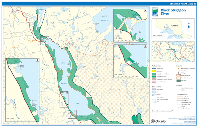
Figure 15: Sensitive Features (Tile 2)

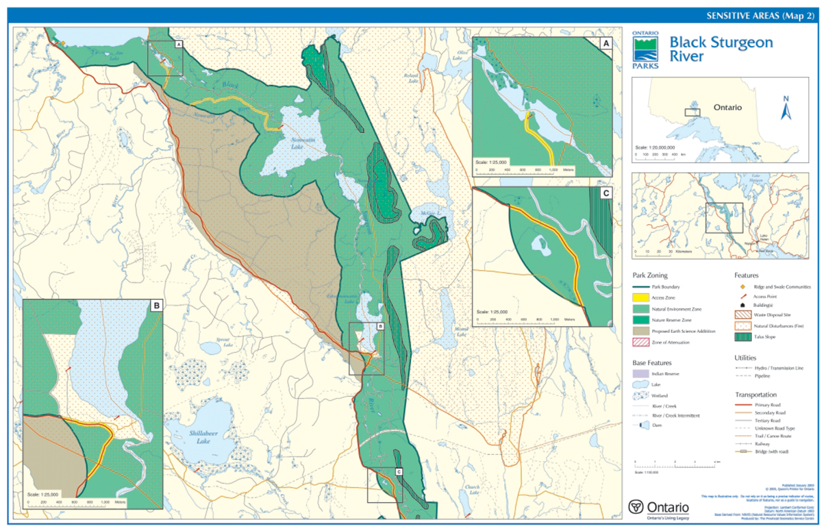
Figure 16: Sensitive Features (Tile 3)
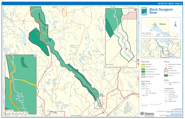
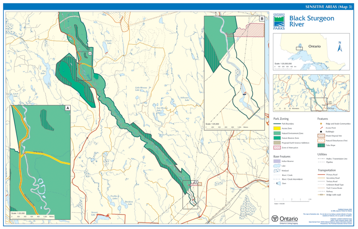
Figure 17: Park Zoning (Tile 1)

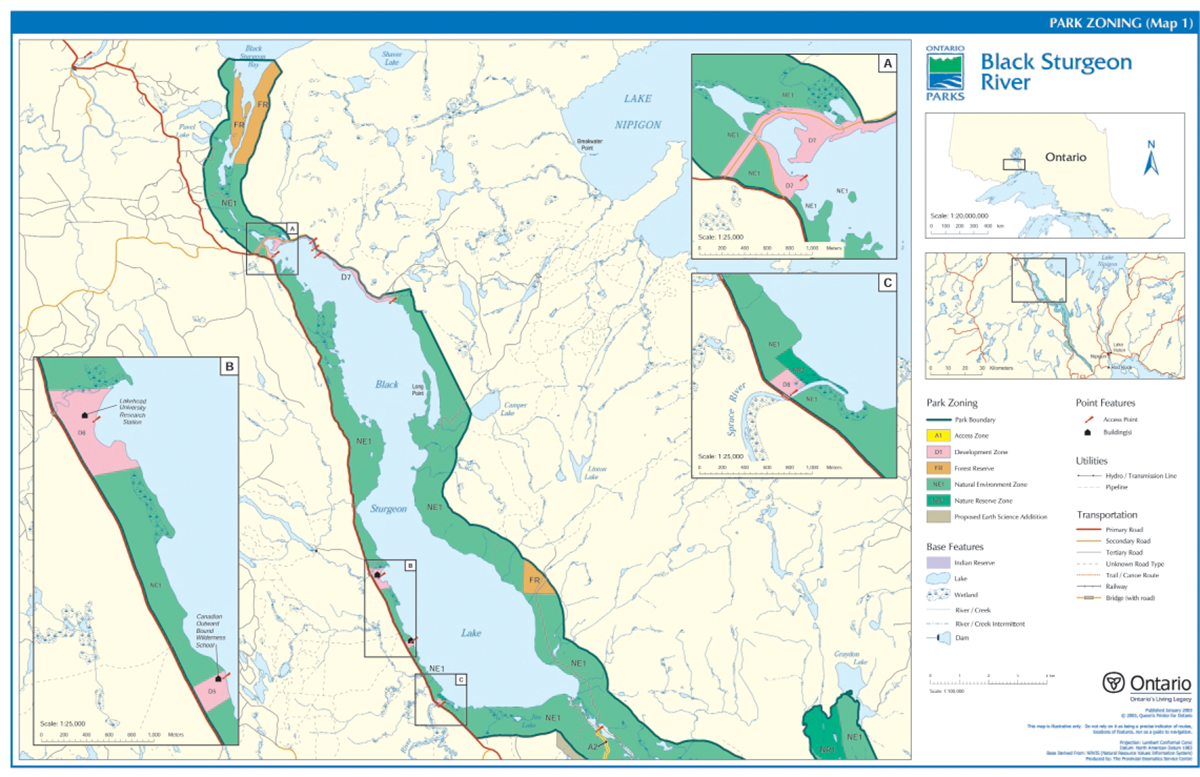
Figure 18: Park Zoning (Tile 2)
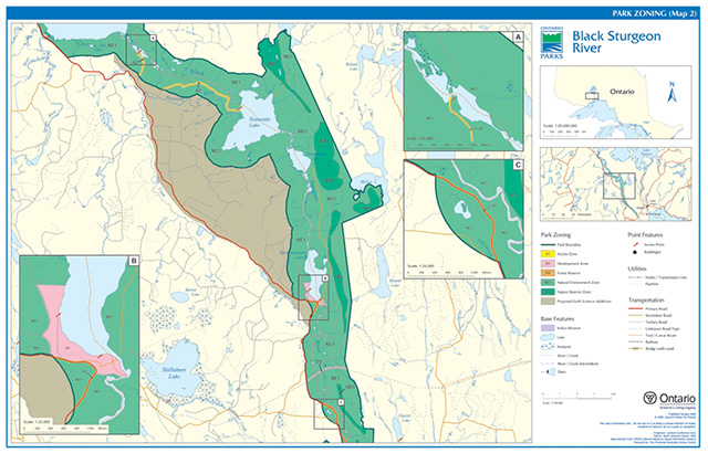
Figure 19: Park Zoning (Tile 3)
Figure 20: Existing Development (Tile 1)
Figure 21: Existing Development (Tile 2)
Figure 22: Existing Development (Tile 3)
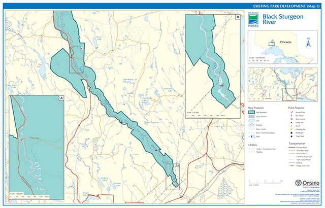