Blue Jay Creek Provincial Park Management Statement
This document provides direction on the management of Blue Jay Creek Provincial Park.
Interim Management Statement
Ontario
2007
Approval Statement
I am pleased to approve this Interim Management Statement for Blue Jay Creek Provincial Park (P1930). This park was regulated as a natural environment class park under the Provincial Parks Act in February of 1997 (O. Reg. 52/97).
This Interim Management Statement provides direction for the protection and management of Blue Jay Creek Provincial Park.
Signed by:
Paul Bewick
Manager
Northeast Zone
Ontario Parks
Date: February 12, 2007
1.0 Introduction
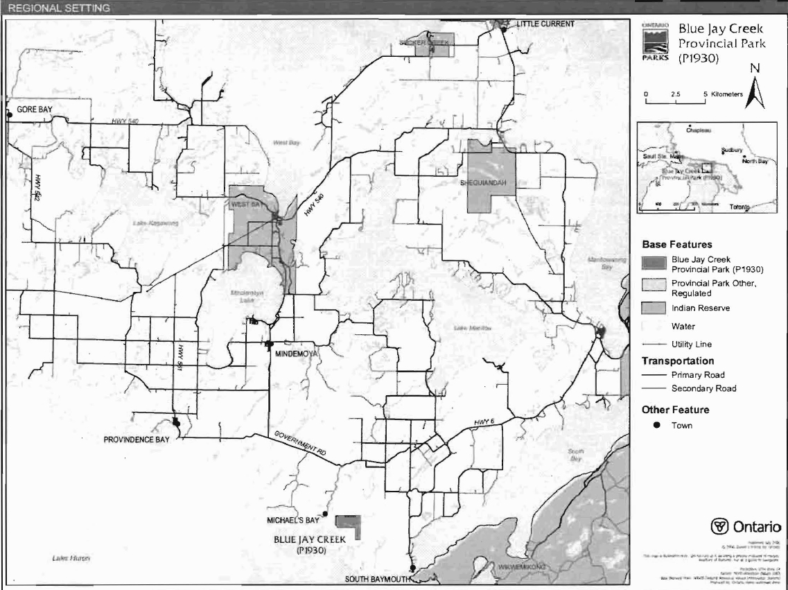
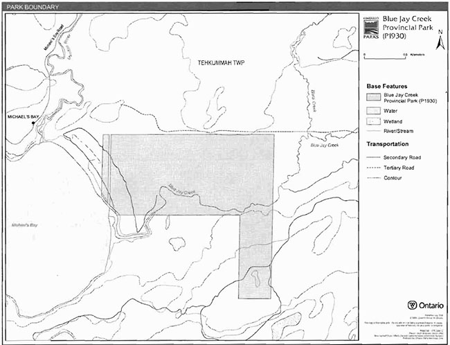
Blue Jay Creek Provincial Park was created during the Ministry of Natural Resources' (MNR) Keep it Wild campaign. Formerly private land, the property was donated to the Crown in 1989 for park purposes. The park is located on Manitoulin Island, 12 kilometres from the town of Tehkummah (Figure 1). This natural environment class park is 245.7 hectares in size (Figure 2).
1.1 Objectives
Blue Jay Creek Provincial Park will be managed consistent with the four objectives for provincial parks:
Protection: To protect provincially significant elements of the natural and cultural landscapes of Ontario.
Recreation: To provide provincial park outdoor recreation opportunities ranging from high intensity day-use to low-intensity wilderness experiences.
Heritage Appreciation: To provide opportunities for exploration and appreciation of the outdoor natural and cultural heritage of Ontario.
Tourism: To provide Ontario’s residents and out-of-province visitors with opportunities to discover and experience the distinctive regions of the province.
2.0 Management Context
The purpose of this Interim Management Statement (IMS) is to provide direction to ensure the custodial management of park resources. Future park planning may be undertaken as required to provide direction on significant decisions regarding resource stewardship, development, operations and permitted uses.
Park management will follow direction from:
- Provincial Parks Act (1990) and regulations
- Ontario Provincial Parks Planning and Management Policies (OMNR 1992)
- Crown Land Use Policy Atlas (OMNR 2004a).
In addressing custodial management obligations to protect park values and ensure public health and safety, Ontario Parks will ensure that policy and Environmental Assessment Act (1990) requirements are implemented.
2.1 Environmental Assessment
As a part of MNR, Ontario Parks is a public sector agency which is subject to the Environmental Assessment Act. Park management will be carried out in accordance with legislation, policies, and guidelines that are required under A Class Environmental Assessment for Provincial Parks and Conservation Reserves (OMNR 2005).
Figure 1: Regional Context

Enlarge Figure 1: Regional Context
Figure 2: Park Boundary
Enlarge Figure 2: Park Boundary
3.0 Park Features and Values
The boundary of Blue Jay Creek Provincial Park does not follow natural features; formerly private property, it is delineated by the lot and concession boundaries on Manitoulin Island. The southwest boundary, however, follows the high water mark of Michael’s Bay. The park also includes wetlands, such as bog, swamps, and fens, as well as a portion of Blue Jay Creek.
3.1 Geological Features
A detailed survey and analysis of the geological features of Blue Jay Creek Provincial Park has not been completed to date.
Blue Jay Creek Provincial Park contains raised beaches which mark the retreat of Lake Huron over thousands of years. The largest raised beach and swale system on Manitoulin Island, the ridges fan out to contact the abutting dolostone uplands to the north. The system is fronted by a modern bayhead sand beach, the width and height of which varies with the changing water levels.
The area is underlain by weakly broken lacustrine silt/clay and sand plains, and weakly broken bedrock plains composed of limestone. Organic deposits overlie sandy till, and aeolian sand occurs in the nearshore and beach areas. A series of raised beaches formed during higher lake levels during Nipissing and post-Nipissing time dominate the park (Noble 1995).
The park’s extensive Nipissing and post-Nipissing beach ridges are considered to be provincially significant (P. Kor, Personal Communication, January 22, 2007).
3.2 Biological Features
A detailed survey and analysis of the biological features of Blue Jay Creek Provincial Park has not been completed to date.
Blue Jay Creek Provincial Park contains some of the largest raised beach and swale system on Manitoulin Island, as well as a core deer wintering yard and a portion of an important trout spawning stream - Blue Jay Creek. The low sand beach fronts blackwater lagoons formed by high water levels breaching the shore. Upland willow thickets are found at the beaches higher elevations (Noble 1995). The forest cover is a mixture of cedar, spruce, and pine, and the extensive wetlands in the area include cedar, black spruce, and black ash swamp forest, open and tree bogs, treed fens, and riparian marshes (OMNR no date).
3.3 Cultural Setting
A detailed survey and analysis of the cultural history and features of Blue Jay Creek Provincial Park has not been completed to date.
Any future planning will be within the context of a provincial framework, A Topical Organization of Ontario History (OMNR 1974). In addition, updates and discussions with First Nations, other agencies and stakeholders may be carried out to identify cultural heritage values and features within the park and their significance. This information may be used to develop management guidelines to conserve and protect representative archaeological and historical values and features, or to provide direction for further research.
3.4 Recreation
A detailed survey and analysis of the recreational opportunities and features of Blue Jay Creek Provincial Park has not been completed to date.
The park offers a variety of recreational settings suitable for canoeing, hunting, fishing, nature appreciation, and exploration. Snowmobile and all-terrain vehicle (ATV) use may occur on tertiary roads in the area. Future management planning will review all uses, including snowmobile and ATV use, to ensure that park features and values are protected, and to assess the potential for these uses to conflict with other uses.
4.0 Aboriginal Uses
Blue Jay Creek Provincial Park lies within the Manitoulin Treaty area of 1845. There are several Aboriginal communities in the vicinity of the park, including Sucker Creek, West Bay, Sheguiandah, and Wikwemikong First Nations.
First Nations have expressed interest in and have shared knowledge of the park and surrounding area. Aboriginal communities have used the area for hunting, trapping, fishing, gathering and travel. These uses may continue, subject to public safety, conservation and other considerations.
Any communications and cooperation between Aboriginal communities and the MNR for planning and operations purposes will be done without prejudice to any future discussions or negotiations between the government of Ontario and Aboriginal communities.
5.0 Stewardship Policies
The removal, damage or defacing of Crown properties, natural objects, relics, and artefacts is not permitted in provincial parks (Provincial Parks Act).
Non-native species will not be deliberately introduced into the park. Where non-native species are already established and threaten park values (i.e., has become invasive), a strategy to control the species may be developed (OMNR 1992).
5.1 Terrestrial Ecosystems
5.1.1 Harvesting
Commercial forest operations are not permitted within the park (OMNR 1992).
The harvest of non-timber forest products such as club moss, Canada yew, etc., will not be permitted within the park (OMNR 1992).
There is no existing authorized wild rice harvesting. New operations will not be permitted.
There are no fuelwood cutting permits currently issued for the park. New permits will not be issued (OMNR 2000).
5.1.2 Insects and Disease
Insects and diseases may be managed where the aesthetic, cultural, or natural values of the park are threatened. Control measures will follow guidelines established by the Ontario Ministry of the Environment (MOE) and MNR. Whenever possible, biological control measures will be given preference over the use of chemicals (OMNR 1992).
5.1.3 Fire
Blue Jay Creek Provincial Park is located within the Great Lakes-St. Lawrence Fire Management Zone. In accordance with existing provincial park policy and the Forest Fire Management Strategy for Ontario, forest fire protection will be carried out in the park as on surrounding lands (OMNR 2004b). Whenever feasible, MNR's Forest Fire Management program will use techniques that minimize damage to the landscape, such as limiting the use of heavy equipment or limiting the number of trees felled during response efforts (OMNR 2004b).
5.1.4 Wildlife Management
Blue Jay Creek Provincial Park is located within Wildlife Management Unit 43B. The removal or harassment of non-game animals is not permitted (Provincial Parks Act).
Hunting
Sport hunting is permitted to continue. Considerations of safety and conservation with respect to hunting may be made through future management planning, which would include public and Aboriginal consultation (OMNR 2000).
The Fish and Wildlife Conservation Act (1997) and the Migratory Birds Convention Act (1994) govern hunting within the park. The Ontario Hunting Regulations Summary contains regulations specific to this area. The harvest of bullfrogs or snapping turtles is illegal in provincial parks.
Bear Management Areas
There are no bear management areas (BMA) on Manitoulin Island. BMAs will not be established in the future.
Trapping
There are no trap line areas on Manitoulin Island. Trap lines will not be established in the future.
5.1.5 Adjacent Land
Forestry
There are no forest management units on Manitoulin Island.
General Use Areas
One general use area surrounds the park: Deer Yards General Use Area (G2026). This area encompasses the major deer yard sites in WMUs 43 and 44. This area also includes portions of the southern shores of Cockburn and Manitoulin islands, plus other yards to the north and west. Most of the land base is patented. The main intent of this general use area is to maintain viable deer wintering habitat.
5.1.6 Land Disposition
New land disposition for the private use of individuals or corporations will not be permitted (OMNR 1992; 2000).
Land Use Permits. Licenses of Occupation. and Unauthorized Occupations
There are no land use permits (LUP), licences of occupation, or known unauthorized occupations within Blue Jay Creek Provincial Park.
Patent Land
Blue Jay Creek Provincial Park is surrounded by private land.
Boat Caches
There are no authorized boat caches within Blue Jay Creek Provincial Park. Boats are not permitted to be left unattended in the park without written permission from the superintendent under the authority of the Provincial Parks Act.
5.1.7 Access and Crossings
Access
Blue Jay Creek Provincial Park can be accessed by bush trails, and from the waters of Blue Jay Creek or Michael’s Bay.
Roads
The park can be accessed on the west and south sides; bush trails pass through the park.
Any proposed development, maintenance or upgrading of existing bush trails must meet all Environmental Assessment Act requirements.
Utility Corridors
There are no utility corridors within the park.
All public utilities (e.g., gas pipelines, transmission lines, communications towers) must avoid park lands wherever possible. New utility corridor crossings may be necessary to maintain essential public services (OMNR 2004a).
Any future utility corridors proposed through the park, where park lands are unavoidable, will be reviewed on a case-by-case basis. Protection of park features and values will be priority and all requirements of the Environmental Assessment Act will be met.
Recreational Trails
There are no authorized trails within Blue Jay Creek Provincial Park. New trails (e.g., hiking) may be developed if the need arises (OMNR 2004a). Any proposed development within the park is subject to Environmental Assessment Act requirements.
Unauthorized snowmobile and all-terrain vehicle use may occur on the bush trails in this park. Future management planning will review all uses, including snowmobile and ATV use, to ensure that park features and values are protected, and to assess the potential for these uses to conflict with park values and other uses. Off-trail ATV and snowmobile use is not permitted.
5.2 Aquatic Ecosystems
Sustaining quality water resources is integral to the protection of park and adjacent land values. The MOE enforces applicable legislation and regulations for water quality.
5.2.1 Water Management
There are no hydro developments, water control structures, or diversions within the park. New commercial hydroelectric developments will not be permitted (OMNR 2000).
Fisheries Management
Fisheries management will complement the maintenance and enhancement of native, self sustaining fish populations (OMNR 1992).
Sport Fishing
Sport fishing is permitted within the park. This activity is governed by legislation and regulations in the Fish and Wildlife Conservation Act and the Fisheries Act (1985). The Recreational Fishing Regulations Summary contains details on the applicable regulations for this area.
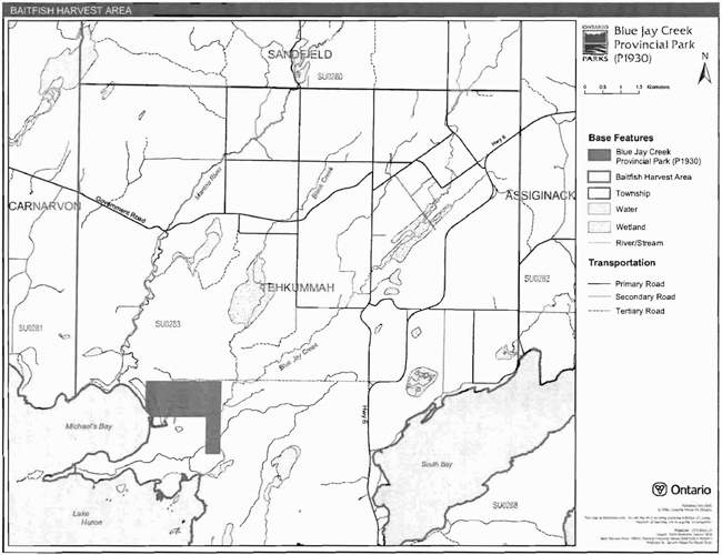
Commercial Baitfish Harvesting
Blue Jay Creek Provincial Park lies within baitfish harvest area SU0283 (Figure 5). Existing commercial baitfish harvesting within waterbodies that are enclosed by the park will be phased out by December 31, 1999. New baitfish licenses will not be permitted (OMNR 2000; 2003).
Fish Stocking
The stocking of native fish species may be considered through park management planning, with full public and Aboriginal consultation. Non-native fish species will not be deliberately introduced into park waters (OMNR 1992).
6.0 Operations Policies
6.1 Recreation Management
Future planning, with full public and Aboriginal consultation, will review direction on recreation uses.
6.1.1 Motorized Recreation
Motorboats
The use of motorboats is permitted to continue, unless park values are being threatened (OMNR 2004a).
Snowmobiles
There are no authorized snowmobile trails within the park; however, snowmobile use may occur on bush trails within the park. Off-trail snowmobile use is not permitted within the park. Proposals for new snowmobile trails may be considered though future planning with public and Aboriginal consultation (OMNR 2000).
All-Terrain Vehicles
There are no authorized ATV trails within the park boundary; however, ATV use may occur on bush trails within the park. Off-road use of all terrain vehicles will not be permitted within the park. Proposals for new trails may only be considered through future planning with public and Aboriginal consultation (OMNR 2000).
6.1.2 Non-Motorized Recreation
Camping
There are no managed campsites in Blue Jay Creek Provincial Park.
Ontario Parks may assess the condition of existing campsites and will maintain, rehabilitate, or close sites as required. If there is an identified need, new campsites may be considered (OMNR 2004a). Infrastructure will be permitted in order to protect park features and values in response to use, environmental deterioration and environmental protection requirements. Any proposed development in the park must fulfill the requirements of the Environmental Assessment Act.
Hiking
There are no authorized hiking trails within the boundaries of this provincial park. If there is an identified need, the development of new hiking trails may be considered. Trail infrastructure to protect park values and features will be permitted. Any proposed development within the park is subject to Environmental Assessment Act requirements.
Figure 3: Baitfish Harvest Area
Enlarge Figure 3: Baitfish Harvest Area
Canoeing/Kayaking
Blue Jay Creek Provincial Park is not on a canoe route but the creek is canoeable. Existing uses may continue, unless park values are threatened (OMNR 2004a). Infrastructure to protect park features and values may be permitted and developed in response to use, environmental deterioration and environmental protection requirements.
6.1.3 Emerging Recreational Uses
There are emerging recreational uses for which there is limited or no policy to deal with their management (e.g., adventure racing and geocaching). The park superintendent will use legislation, policy, and guidelines which are in place to manage emerging uses in the interim.
6.2 Development
Infrastructure to protect park features and values may be permitted and developed in response to use, environmental deterioration, and environmental protection requirements. Any proposed development within the park is subject to the Environmental Assessment Act.
6.3 Commercial Tourism
New commercial tourism facilities may be considered where they would be consistent with park policy (OMNR 2004a). Any development must meet the requirements of the Environmental Assessment Act.
7.0 Cultural Resources
An assessment of the cultural resources specific to Blue Jay Creek Provincial Park has not yet been completed. The management of any cultural values within this park will be directed toward protection and heritage appreciation (OMNR 1992).
8.0 Heritage Education
Literature and other supporting information may be developed to describe the park in the context of Ontario’s provincial park system. Boundary limits, significant heritage features and permitted uses of the may be included in park literature.
Prospective park visitors may be informed about the sensitivity and significance of park values through park literature.
9.0 Research
Scientific research by qualified individuals which contributes to the knowledge of natural or cultural history, or to environmental or recreational management, may be encouraged in the park. Ontario Parks will encourage institutions, such as universities, to undertake research projects.
All research programs will require the approval of Ontario Parks and are subject to park policy and other applicable legislation. Any materials removed from the park will remain the property of Ontario Parks.
Approved research activities and facilities will be compatible with the park’s protection objective. Any site which is affected by research will be rehabilitated as closely as possible to its original state. Environmental Assessment Act requirements will apply.
10.0 References
Environmental Assessment Act, 1990.
Fish and Wildlife Conservation Act, 1997.
Fisheries Act, 1985.
Kor, P.S.G. Personal Communication, January 22, 2007.
Migratory Birds Convention Act, 1994.
Noble, T.W., 1995. Site District 5E2 Gap Analysis.
Ontario Ministry of Natural Resources, no date. Natural Heritage Areas Candidate SiteInformation: Blue Jay Creek Property (Hindman Donation).
Ontario Ministry of Natural Resources, 1974. A Topical Organization of Ontario History. Historic Sites Branch Division of Parks.
Ontario Ministry of Natural Resources, 1992. Ontario Provincial Parks Planning and Management Policies. 1992 Update.
Ontario Ministry of Natural Resources, 2000. Ontario’s Living Legacy Land Use Strategy (Policy Clarification).
Ontario Ministry of Natural Resources (OMNR), 2003. Directions for Commercial Resource Use Activities in Provincial Parks and Conservation Reserves. 5 pp.
Ontario Ministry of Natural Resources, 2004a. Crown Land Use Policy Atlas.
Ontario Ministry of Natural Resources (OMNR), 2004b. Forest Fire Management Strategy for Ontario.
Ontario Ministry of Natural Resources (OMNR), 2005. A Class Environmental Assessment forProvincial Parks and Conservation Reserves.
Provincial Parks Act, 1990.
11.0 Appendix A: Background Information
| Name | Blue Jay Creek Provincial Park (P1930) |
|---|---|
| Classification | Natural Environment |
| Ecoregion/Ecodistrict | 6E/6E-17 |
| OMNR Administrative Region/District | Northeast Region - Espanola District |
| Total Area (ha) | 245.7 |
| Regulation Date and Number | February 1997 (O. Reg. 52/97) |
Representation
Earth Science:
There are currently no reports describing the earth science features of the park.
Blue Jay Creek Provincial Park contains raised beaches which mark the retreat of Lake Huron over thousands of years. The largest raised beach and swale system on Manitoulin Island, the ridges fan out to contact the abutting dolostone uplands to the north. The system is fronted by a modern bayhead sand beach, the width and height of which varies with the changing water levels.
The area is underlain by weakly broken lacustrine silt/clay and sand plains, and weakly broken bedrock plains composed of limestone. Organic deposits overlie sandy till, and eolian sand occurs in the nearshore and beach areas. A series of raised beaches formed during higher lake levels during Nipissing and post-Nipissing time dominate the park (Noble 1995).
The park’s extensive Nipissing and post-Nipissing beach ridges are considered to be provincially significant (P. Kor, Personal Communication, January 22, 2007).
Life Science:
There are currently no reports describing the life science features of the park.
Blue Jay Creek Provincial Park contains some of the largest raised beach and swale system on Manitoulin Island which harbour a variety of wetland and upland vegetation types, as well as a core deer wintering yard and a portion of Blue Jay Creek, which is an important trout spawning stream. The low sand beach fronts blackwater lagoons formed by high water levels breaching the shore. Upland willow thickets are found at the beaches higher elevations (Noble 1995). The forest cover is a mixture of cedar, spruce, and pine, and the extensive wetlands in the area include cedar, black spruce, and black ash swamp forest, open and tree bogs, treed fens, and riparian marshes (OMNR no date).
Cultural Resources:
There are currently no reports describing the cultural resources of the park.
Recreation:
There are currently no reports describing the recreational features of the park. The park may accommodate a variety of recreational uses, including canoeing, hunting, fishing, nature appreciation, and exploration. Snowmobile and all-terrain vehicle (ATV) use may occur on bush trails in the area. Future management planning will review all uses, including snowmobile and ATV use, to ensure that park features and values are protected, and to assess the potential for these uses to conflict with other uses.