Bonheur River Kame Provincial Park Management Statement
This document provides direction on the management of Bonheur River Kame Provincial Park.
1985 Government of Ontario
Additional copies of this publication are available from the Ignace District Office, Box 448, Hwy. #599, Ignace, Ontario POT 1TO
February, 1986
Regional Director’s Approval Statement
This Interim Management Statement will provide interim direction for the management of the Bonheur River Kame Provincial Nature Reserve until a comprehensive Park Management Plan is prepared.
This statement will provide the basis for the subsequent preparation of the Park Management Plan.
I am pleased to approve this Interim Management Statement for the Bonheur River Kame Provincial Nature Reserve.
Signed by:
D.R. Johnston
Regional Director
Northwest Region
Introduction
The purpose of this Interim Management Statement is to identify:
- park values which are to be protected;
- resource management prescriptions necessary to protect these values; and
- restrictions on use of natural resources within the park.
This Interim Management Statement is not intended to replace a Park Management Plan. Rather it is intended to guide the use of natural resources and related activities within the park until such a time as a Park Management Plan is prepared.
The guidelines that have been developed are based on information contained in the Ignace District Land Use Guidelines.
Background Information:
| Name | Bonheur River Kame |
|---|---|
| Proposed Class | Nature Reserve |
| M.N.R. District | Ignace |
| M.N.R. Region | Northwestern |
| Total Area (ha) | 800 |
| Land | N/A |
| Water | N/A |
| Site Region | 3W-Lake Nipigon |
| Site District | 3W-2 |
| Date in Regulation | 85.01.24 |
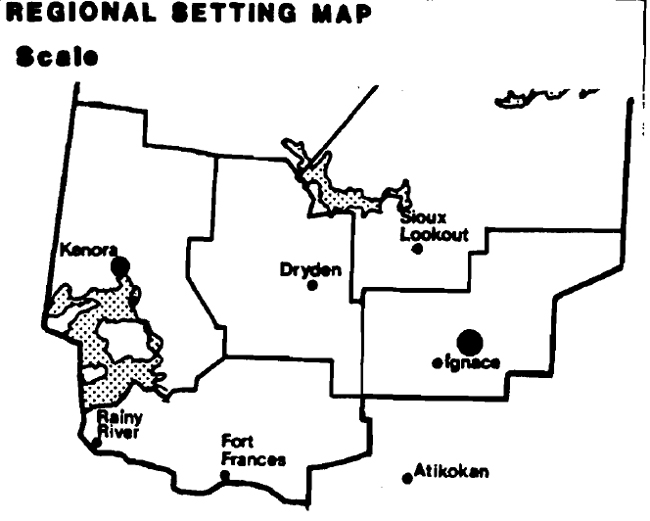
Bonheur River Kame Regional Setting Map
Targets
1. Life Science Representation
| Site Type/Landscape Unit | Species/Communities |
|---|---|
| Landscape Unit 30 - Raven Lake Outwash Plain | Southern Boreal Forest Region and associated vegetation communities. |
2. Earth Science Representation
| Geological Theme | Feature |
|---|---|
| Timiskaming Interstadial | Unmodified "textbook" quality kame |
3. Cultural Resource Representation
| Theme | Theme Segment |
|---|---|
| N/A | N/A |
4. Recreation Opportunities
| Day Use | Car Camping | Wilderness/Back Country |
|---|---|---|
| N/A | N/A | N/A |
5. Inventories
| Level/Type | Earth Science | Life Science | Cultural | Recreational | Other |
|---|---|---|---|---|---|
| Reconnaissance Completion Date | 1979 | N/A | N/A | N/A | N/A |
| Detailed Completion Date | N/A | N/A | N/A | N/A | N/A |
I Land Tenure
There are presently no alienated lands within the park boundary.
Guideline
Requests for any form of Crown land disposition will not be considered.
II Land Acquistion/Disposition
There are no patented properties located within the park boundary. In addition, the park is completely surrounded by Crown land.
Guideline
The disposition of Crown-owned lands within the park will not be considered.
III Existing/Proposed Development
There are no existing facilities or developments within the park.
Guideline:
Proposals for park development will not be considered pending the completion of the park management plan. Park development will be limited to trails, necessary signage and interpretive facilities for research and educational purposes.
IV Recreation Activities
There are presently no recreational activities occurring within the park due largely to the inaccessibility of the area.
Guideline:
The Ignace District Land Use Guidelines indicate that wildlife viewing is an acceptable activity within the park. Sport hunting is not permitted.
V Commercial Activities
A portion of two traplines are included within the park area.
The park is surrounded by the Great Lakes Forest Products English River Forest Management Agreement area.
Guideline
Trapping is not permitted within the park. Existing trapline boundaries will be amended to exclude the park area.
Timber harvesting operations are not permitted within the park. The park has been excluded from the English River Forest Management Agreement.
In summary, no commercial activities will be permitted to occur within the park pending the completion of the park management plan.
VI Native Interests
There are no known Native interests in the park area.
VII Natural Resources
The primary natural resource value of the park is a distinctive, unmodified Kame deposit rising some 80 m above the surrounding landscape. Management efforts will be directed towards the protection of this resource.
VIII Cultural Resources
No known cultural resources have been identified to date.
IX Client Services
Information on the natural resource values of this nature reserve will be made available to the public in an attempt to foster an understanding and appreciation for this park.
X Research
A more detailed earth science and life science inventory will be necessary prior to the preparation of the park management plan.
XI Marketing
A marketing strategy for this nature reserve class provincial park will be addressed during the preparation of the park management plan.
Sources/References
KOR, P. Earth Science Inventory Checklist - Bonheur River Kame, O.M.N.R., 1979
Ontario Ministry of Natural Resources, Ignace District Land Use Guidelines, 1983
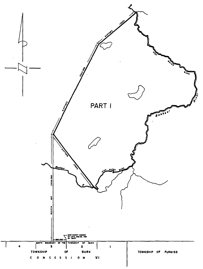
Map of Bonheur Provincial Park Natural Reserve
Bonheur River Kame
- Area Description
Located directly north of Burk Township, this 720 hectare recommended park consists of a kame, of 'textbook' quality which rises over 80 metres above its surroundings. The kame is largely unmodified by post glacial lake action and undisturbed by man’s action. It would be highly sensitive to denudation of vegetation. - Land Use Intent
The area is recommended for park status. The main purpose of this recommended park is to protect and represent the kame, a significant earth science feature. - Land Use Activity for Area No. 13- Bonheur River Kame
| Activity | Acceptable | Recommended Guidelines |
|---|---|---|
| Aggregate Extraction | No | N/A |
| Agriculture | No | N/A |
| Bait Fishing | No | N/A |
| Commercial Fishing | No | N/A |
| Cottaging | No | N/A |
| Crown Land Recreation | N/A | N/A |
| Forestry | No | N/A |
| Hunting | No | N/A |
| Mining | No | N/A |
| Provincial Parks | Yes | Recommended for park status. |
| Roads | No | N/A |
| Rural Residential | No | N/A |
| Sports Fishing | No | N/A |
| Tourism | No | N/A |
| Trapping | No | N/A |
| Wildlife.Viewing | Yes | N/A |
| Wild Rice Harvesting | No | N/A |
| Urban Development | No | N/A |
Earth Science Inventory Checklist
| Name | Bonheaur River Kame |
|---|---|
| Map Name | Bonheur |
| Map Number | 52G/6 |
| UTM Reference | 285745 |
| County | N/A |
| Latitude | 49 25' |
| Longitude | 91 14' |
| Altitude Minimum | 434 m |
| Altitude Maximum | 520 m+ |
| Township | N/A |
| Lot Concession | About 15 km north of Hwy 17 at Raven Lake, and 8 km south of Sowden Lake |
| Area | N/A |
| Ownership | N/A |
| Administration | N/A |
| MNR Region & District | NWR - Ignace |
| Conservation Authority | N/A |
Aerial Photographs - Basemaps
| Year | Roll | Flight Line | Numbers |
|---|---|---|---|
| 1975 | 11 | 4917 | 107-109 |
| 1975 | 11 | 4916 | 147-149 |
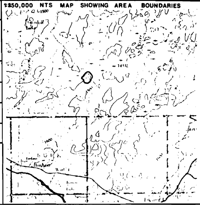
Map showing Bonheaur River Kame Area Boundaries
Earth Science Features
- excellent quality individual kame mound visible for long distance
- rises out of a peat-covered outwash plain
Sensitivity
- probably high aggregate potential; high sensitivity to denudation of vegetation
Significance
- "text book" quality of kame with high integrity
Major References
- undocumented
Physical Features:
The kame described in this checksheet was found by chance when it was observed from the north end of Sowden Lake, about 12 km north of the feature, during a reconnaissance flight. Subsequent investigations from the fixed-wing aircraft revealed a very distinct, steep-sided mound with twin peaks, rising over 80 m above the surrounding peatland. The kame is heavily vegetated, and no exposures of surface material were seen from the air. The feature is slightly less than 1 km by 1 km in area, being almost circular in plain view. A low, wide ridge joins the south end of the kame to a lower, smaller kame 2-5 km to the south (at UTM 280720). The peatland which virtually surrounds the kame is situated on an extensive outwash plain associated with the deglaciation of the ice mass from the Hartman position to the Lac Seul position during the Timiskaming Interstadial. The flatness of the peatland accentuates the abrupt slopes and height of the single kame.
Significance:
The Bonheur River kame is very significant in that it represents a single kame of "text book" quality. Kames often occur as single mounds, the result of fluvial deposition into small ponds on or within a stagnant ice mass (Embleton and King, 1975, p.487). The kame is unmodified by post-glacial lake action, except probably some redistribution of basal deposits by glacial meltwaters. The feature is distinctive, highly educational, of high interpretive value, and an excellent representation of a single, unmodified kame. The feature has not been disturbed by man’s activities, due in part to the difficulty of access.
Recommendations:
The kame and a portion of the surrounding peatland is here recommended for inclusion within the parks system as a result of its significance in representing a specific landform. The land area required to preserve this feature is minimal, especially considering the difficult access. There is no road access, and none is likely in the near future, leaving the only means of access via helicopter, or boat from Bonheur River, both of which would require a wet walk through the peatland.