Bonnechere Provincial Park Management Plan
This document provides direction on the management of Bonnechere Provincial Park.
MNR 3479
ISBN 0-7729-1027-8
© 1986 Government of Ontario
Limited copies of this publication are obtainable at the Ministry of Natural Resources, Huntsville Regional Office, Box 9000, Huntsville, Ontario, POA 1KO,
Approval Statement
Bonnechere Provincial Park provides access to Round Lake and the Bonnechere River, one of the most picturesque examples of glacial lake topography in Ontario. From the Park’s inception as a private campground, anglers, boaters and campers have come to use this park as a focus for their favourite pastimes.
"We are pleased to approve the Bonnechere Lake Provincial Park Management Plan, as official policy for the management and development of this park. The park reflects this Ministry’s intent to protect natural and cultural features of Bonnechere Park and maintain and develop high quality opportunities for outdoor recreation and heritage appreciation for both residents of Ontario and visitors to the Province."
1.0 Introduction
Bonnechere Provincial Park is situated in Richards Township, County of Renfrew, in east central Ontario. The Park is located on the northwest face of Round Lake (Figure 1). Highway 62 runs along its north and west boundary providing good access from the large urban centres of Eganville, Pembroke, Barry’s Bay and Bancroft. The Park is approximately 160 kilometres northwest of Ottawa, 48 kilometres west of Pembroke and 400 kilometres northeast of Toronto by road.
Prior to the purchase and subsequent opening to the public in 1967, Bonnechere was run as a private campground. The Foy property, located on the northeast side of Round Lake was purchased in 1968 for park day use purposes and was put into regulation in 1985 as Foy Provincial Park. However, no development has occurred in Foy with the exception of a junior ranger camp, which has been in operation for the past eight years. The relationship between these parks is substantial, however, only Bonnechere Park will be emphasized in this management plan. In addition, Bonnechere Park is located at the mouth of the Bonnechere River, a recommended candidate park, linking Bonnechere Park to Algonquin Provincial Park. Inquiries concerning Foy Park will be referred to the Foy Provincial Park Management Plan.
Bonnechere Provincial Park, a Recreation class park, consists of an area of 116 hectares. The Park contains 113 campsites at a density of 10.7 sites per hectare, which is within the design guidelines for Recreation Parks.
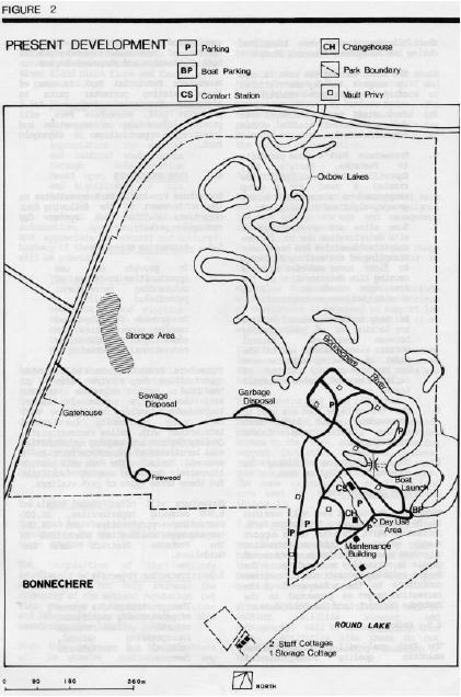
A central firewood yard, a self–deposit garbage building and trailer sanitary dumping station are provided along the entrance road of the Park preceding the camping area (Figure 2). Vault privies and a centrally located comfort station containing flush toilets, showers and laundry facilities service the campground. A day use area consisting of strategically placed vault privies, change house, a 181 car parking lot and a 306 metre sand beach is located on the shore of Row–El Lake. A boat launching area is situated on the Bonnechere River. Both campers and day visitors use these day use facilities.
Bonnechere Provincial Park offers its visitors a safe sandy beach, good fishing, boating on Round Lake, and canoeing on the Bonnechere River. There are no walking trails within the Park’s boundary. Park operation facilities are at best makeshift. Part of the former Superintendent’s residence has been transformed into a park office. The maintenance staff work out of a former concession building. Some park supplies and equipment are stored in the backyard of the previous Superintendent’s residence. Both buildings are adjacent to the day use area. Two cottages west of Bonnechere Park’s boundary accommodate park staff.
Bonnechere Provincial Park is located within the Grenville Province of the Precambrian Shield. Bonnechere is underlain by metasediuentary gneisses and plutonic bedrock, the oldest rocks in the area. The topography of Bonnechere Park can be attributed to the last ice–age and the large glacial lake, which covered the present–day Round and Golden Lakes. The Park is mostly flat with the exception of an old beach ridge, a remnant of a glacial lake, running through its northern portion. The Bonnechere River has formed oxbow lakes as it meanders through the Park’s deep sand deposits.
The park area is located within the Middle Ottawa Section of the Great Lakes–St. Lawrence Forest Region. Two forest communities dominate Bonnechere Park. Jack pine is found on the well–drained deltaic sands and the community of red maple, silver maple, basswood and bur oak are found in the cool, wet lowlands of the Bonnechere River. Bonnechere Park contains a representative portion of the Bonnechere River flood plain which is regionally significant due to the fauna and flora found there (Figure 3).
2.0 Summary of Significant Issues
Bonnechere Provincial Park has developed into a park, which satisfies special needs of its visitors for camping and day use facilities. However problems that exist within the Park are basically the result of intensive use of the small park area.
Figure 1: Regional Context
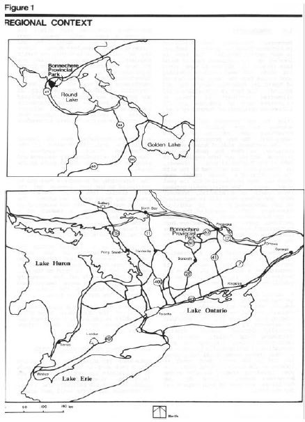
Figure 2: Present Development
The following issues were identified during the Management Planning study:
- Campers and day use visitors use the beach and day use area, often causing crowded conditions
- Park staff have no control over day use visitor traffic within Bonnechere Park
- Bonnechere Park’s close proximity to Pembroke, Barry’s Bay, Eganville and Killaloe Station has created a need for a group campground to accommodate school groups, clubs and scouting, etc.
- Sane sites are showing signs of site deterioration due to intense campsite densities and heavy use. Trampling of the soil and damage to floor cover and tree roots is causing slow deterioration of the area tree stands as well as erosion problems on campsites.
In many instances natural buffers are lacking or of poor quality between campsites. Natural buffers along roadways and in the midst of existing campsites need to be upgraded by virtue of implantation of bushes and small trees - The two cottages that are used to accommodate staff lack both running water and indoor conveniences
- The maintenance building is located in the day use area
3.0 Park Classification
Bonnechere Provincial Park will continue to be classified as a Recreation Park. Recreation Parks are areas, which support a wide variety of outdoor recreation opportunities for large numbers of people in attractive surroundings. The Park’s existing recreation opportunities contribute to the achievement of the recreation target as presented in the Pembroke District Land Use Guidelines.
4.0 Park Goal
The Park goal will be to provide and maintain quality summer–oriented camping and day use facilities within the context of recreation classed Parks for both destination and stopover campers.
Bonnechere Provincial Park is one of three existing perimeter parks to Algonquin Provincial Park. As a perimeter park, Bonnechere Park will provide information on recreation and interpretive opportunities in Algonquin Park.
5.0 Park Objectives
Bonnechere Provincial Park contributes to the achievement of the following four objectives of the park system for recreation parks.
5.1 Recreation Objective
To provide day use opportunities in areas of outstanding recreational potential
To provide facility-based camping opportunities in areas of outstanding recreational potential
Bonnechere Provincial Park will provide opportunities for a wide variety of healthful and enjoyable outdoor activities on a seasonal basis. Individuals, families and groups will have every opportunity for social interaction with fellow recreationists.
Quality day use and camping opportunities will be offered at Bonnechere Park on a seasonal basis.
The Park will provide intensively developed calming facilities for these three types of park visitors. Bonnechere will offer annual totals of 6,000 swimming opportunities, 26,000 picnicking opportunities and 24,000 camping opportunities as identified in the Pembroke District Land Use Guidelines.
5.2 Protection Objective
The protection of a system of provincially significant natural environments incorporates natural, cultural and recreational features.
By ways of development and management strategies, significant earth and life science features such as the Bonnechere River flood plain flora and fauna, will be protected.
5.3 Heritage Appreciation Objective
To provide opportunities for exploration and appreciation for natural and cultural environments through interpretation based upon the character and significance of this Recreation Park.
By way of self–use facilities and information, opportunities to explore and appreciate the natural and cultural history of the Park and surrounding area will be provided.
5.4 Tourism Objective
To facilitate travel by residents of and visitors to Ontario who are discovering and experiencing the distinctive regions of the province.
Bonnechere Provincial Park will provide day use and camping opportunities for travelers through Ontario, as well as destination camping opportunities for those attracted from considerable distances.
Bonnechere’s existence in the tourism industry generates $816,453 worth of expenditures and supports 17 jobs in Ontario’s economy.
6.0 Park Boundary
The park Boundary should be extended to incorporate the mouth of the Bonnechere River (Figure 5).
The acquisition of the wetlands immediately to the east of the river mouth would not only increase the diversity of the wetland vegetation hit also preserve a sequence of past river and lake shorelines associated with this meandering river (Noble, 1983).
With this addition to the Park there will be greater control over any development of the Bonnechere River between Highway 62 and Round Lake.
This proposed addition include the south half of patent lot 22, Concession VI and a 17.2 hectare area under a License of Occupation #8414 by Renfrew Hydro. The Ministry should pursue purchase of the patent land if it becomes available for sale and acquire management control of the license of occupation.
7.0 Zoning
Lands and waters within a Provincial Park are zoned so that they may be assigned the most appropriate use and management relative to the park.
Facilities and services for a wide range of camping activities are provided in Development Zones.
Natural environment Zones include attractive landscapes in which a minimum of development is required to support low intensity recreational activities (i.e. walking trails).
Significant earth and life science features, which require management distinct from that in adjacent zones, are included in Nature Reserve Zones.
7.1 Development Zone (83.6 Ha)
The Development Zone includes all present park development. This zone provides access to the Park and all recreation support facilities (campsites, beaches, comfort stations, gatehouse, staff quarters, etc.) located within this zone.
The zone is comprised of all the land area west of the Bonnechere River (Figure 4).
7.2 Natural Environment Zone (13.9 Ha)
The lard area will act as a buffer between the east boundary of the Park and the Nature Reserve Zone. No park development has taken place within this portion of the park area.
Extensive recreation activities, such as walking, wildlife viewing and photography will be allowed within this zone. Activities like these do not greatly affect the existing vegetation or the landscape.
Figure 3: Significant Features
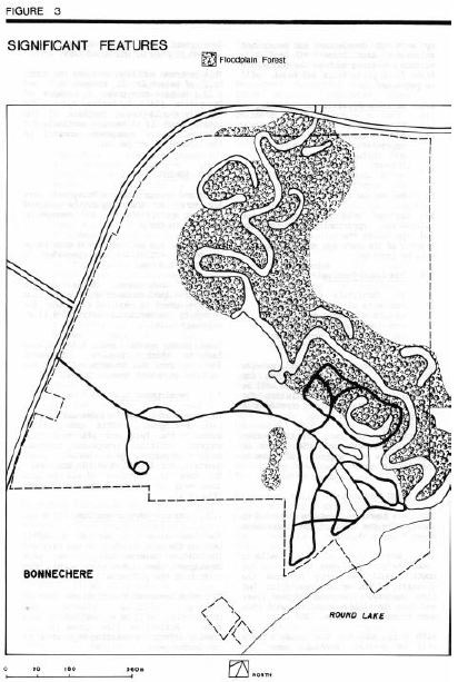
Figure 4: Zoning
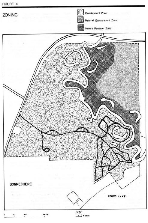
7.3 Nature Reserve Zone (15.5 Ha)
The Nature Reserve Zone protects a good representative example of the Bonnechere River flood plain. It consists of red maple and silver maple stands along the river, and jack pine forest on the sand flats higher up.
The Bonnechere River flows through the Ottawa–Bonnechere Graben. This valley has created a corridor for southern species to move northward. Southern plants such as cardinal flower, basswood, and bur oak indicate a warmer, more sheltered environment.
The site also provides habitat for the rare wood turtle. The Bonnechere River is one of the last strongholds of this species in Ontario. A large population of the turtles exists along the river and it is quite probable that they extend into the Park.
Development will be limited to an interpretive walking trail and a footbridge across the Bonnechere River. Temporary facilities for education, research, and management will also be allowed.
8.0 Resource Management
Natural resources of Bonnechere Park will be managed within the administrative policies for resource management in Recreation Parks.
8.1 Vegetation
Certain management techniques must be applied to maintain a particular kind and quality of vegetation in a given area in the Park. Zones with vegetation progressing through natural succession will have different management techniques from zones where vegetation is maintained at its present stage of natural succession.
Some management practices will produce small quantities of wood as by–products of selective and dead tree removal. The wood, depending on type and quality, can be used for firewood, sawlogs, posts, or other required items within the Park. By this means, small savings in both maintenance and capital costs may be realized. However, it must be remembered that the main purpose of these management techniques is to maintain or create a particular quality of vegetation and not to generate revenue.
A vegetation management plan is required. The plan will meet the diverse management requirements specific to the Park and to provide direction to park staff. The plan will be prepared by the Park Superintendent in conjunction with other Ministry staff and outside experts as required and in consideration of the following prescriptions for each zone.
8.1.1 Development Zone
Vegetation cover in the beach area will be maintained in a park–like setting, with varying aged overstory and replacement trees in a sparse understory. Open spaces described earlier will also be developed and maintained.
The vegetation quality will be maintained or improved where appropriate in existing and future campground areas. Ground and understory vegetation will be managed to provide and maintain visual buffers for privacy between campsites.
8.1.2 Nature Reserve Zone
Areas designated under this zoning will be allowed to progress through natural succession.
8.1.3 Natural and Environment Zone
Areas designated under this zoning will have a silvicultural program promote and maintain growth of healthy aesthetically pleasing forest cover.
8.2 Wildlife
There are no wildlife management programs within the Park and no programs are anticipated at this time.
Hunting is prohibited in Bonnechere Provincial Park.
Permission will not be given for establishment of new traplines within the Park area. Portions of existing traplines will be phased out when subject to transfer. Trapping of 'nuisance' animals will be permitted at the request of the Park Superintendent. However, before a nuisance animal–trapping program is initiated, the methods and guidelines should be spelled out in a "Wildlife Management Plan"; to be written for the Park.
8.3 Fisheries
Round Lake is a cold water lake. Although once a prime source for lake trout fishing opportunities, the stocking of lake trout has been discontinued due to incomplete natural stocking, over–harvest, undesirable species composition and degraded habitat.
Other fish species present in Round Lake are yellow pickerel, whitefish, northern pike, smallmouth bass and largemouth bass.
Up until the 1960's, smallmouth bass and maskinonge were planted in the Bonnechere River north of the Park. Smallmouth bass, yellow pickerel aid speckled trout are presently found in the Bonnechere River.
There is no commercial fishing on Row–El Lake or the Bonnechere River.
8.4 Resource Extraction
No commercial extraction of resources will be permitted within the Park area.
There are no mining activities in the immediate vicinity of Bonnechere Park.
The Park has an abandoned sandpit that is now used for park storage purposes.
8.5 Water
The present water quality–sampling program will control water quality of Round Lake and Bonnechere River. This Ministry in cooperation with the Ministry of the Environment will investigate any deterioration in water quality.
The water level on Round Lake is controlled by the Hydro–Electric Power Commission of the Town of Renfrew. The water level is not to exceed the 555.6 foot contour. This water level control has no major effects on water –based recreation opportunities during the park operating season.
The 1978 survey of Round Lake by the Ministry of the Environment revealed excellent water quality conditions for recreation use. Seasonal average chlorophyll and Secchi disc visibility measurements indicated a low level of biological productivity (i.e. algae) and a high degree of water clarity.
8.6 Fire
Normal methods of fire detection and suppression will be carried out to protect the Park’s natural resources.
8.7 Insects and Disease
Measures for insects and disease control will be permitted, when necessary, to protect visitor health and park values. The Nature Reserve Zone will be excluded unless the very values that are being protected by Nature Reserve zoning are being threatened or attacked by insects and/or disease.
9.0 Visitor Services
Bonnechere Provincial Park will offer a self–use level of visitor services programming which will include the three components of visitor services: Information, Interpretation and Outdoor Recreation. The Park will be operated in accordance with the current Operating Plan.
9.1 Information
Information on the Park and nearby attractions will be provided to visitors through a carefully organized system of signage, publications, displays, limited personal service and possible audio–visual programs.
Although there will be no visitor services staff, the park visitor will have access to informed park staff. Park staff should be knowledgeable about the Park, its facilities, rules and regulations as well as local area services and attractions.
9.2 Interpretation
What went on along the Bonnechere River Basin is representative of the natural and cultural heritage of the Ottawa River and Eastern Ontario. Although the Park is small it has witnessed the events of tine in the Bonnechere River Valley.
There are three sub-themes within the watershed theme that have been identified in the Algonquin Region Visitors Strategy.
- The physical origins of the Canadian Shield
- Plants and animals of the river flood plain
- Man– his use of the watershed for timber
The park visitor will become aware of these themes through displays, publications, guest interpreters and appropriate attractions near the Park.
9.3 Recreation
The most popular activities of the Park are relaxing, swimming, boating and fishing. Round Lake, with an area of 3,074 hectares, provides ample boating and fishing opportunities. The day use area includes a 306 metre sand beach located on the shore of Round Lake and a boat launching area situated on the Bonnechere River.
With canoe–in campsites, canoeing up the Bonnechere River and the extensive canoe route system to the north in Algonquin Park, an information program on back–country travel rules, regulations and etiquette will be provided. Special groups such as Canoe Ontario Canoe Canada, etc. could possibly offer basic canoeing skills instruction as a special event in the summer.
9.4 Recreation Management
To maintain the Park’s recreational facilities at a high standard of quality, certain management guidelines need to be established for Bonnechere Park. Proposed trails, campsites and the beach are three recreation facilities, which require the nest attention.
The present layout of Bonnechere Provincial Park causes particular problems in the management of the Park. Both campers and day users often causing crowded conditions utilize the beach area. Also, the park staff has no control over day–user vehicle traffic within Bonnechere Park.
By itself, Bonnechere Park does not have the capability to provide day–use and camping experiences appropriate for a Provincial Recreation Park. With the addition of nearby Foy Provincial Park, a day use only park, these problems can begin to be solved.
Bonnechere Park would be redeveloped to provide camping facilities only. Foy Park would be developed to provide a day use recreation area. These alternatives would be capable of resolving the development issues as well as meeting a portion of the future demand for additional day use areas and campsites.
9.5 Marketing
A marketing plan to attract more visitors to Bonnechere Park throughout its operating season will be prepared with the following objectives: to hold present clientele (average length of stay in 1984 3.4 days, down 0.2 since 1979); to attract campers during low use periods in the mid–week (1984 July–August occupancy rate 68 percent, an increase of 8 percent in one year); to augment involvement with the commercial sector by encouraging park users to use and take advantage of local tourist services and attractions; to generally stimulate interaction between the Park and the private tourist and commercial sector in the vicinity and to encourage day visitor use at Foy Provincial Park once Foy is developed enough to accommodate use, thus phasing out day use in Bonnechere.
10.0 Development
Development will proceed in accordance with Figure 5 and the following guidelines. In all instances, detailed site plans will be completed and approved in advance of rehabilitation of existing facilities or the development of new facilities. Development projects will be phased according to the Implementation Strategy (Section 10.0) as needed and funding permits. The requirements of the Environmental Assessment Act will be adhered to.
10.1 Group Campsite
A group camping area separate f ran other campgrounds will be located west of the trailer sanitary station (Figure 4) with one major campground unit large enough to accommodate 30 to 60 persons. A parking lot will provide parking for eight cars and two buses. Vault toilets with will service this area vanities at a level to satisfy demand requirements.
Figure 5: Future Development
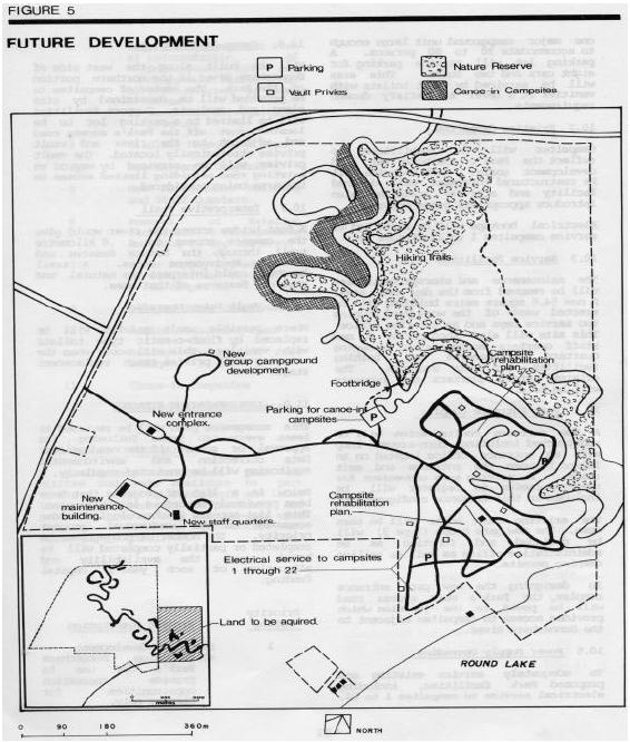
10.2 Existing Campsites
Campsites will be rehabilitated to reflect the Park’s characteristic and development goals.
Each campsite will be restructured to create well–defined facility and activity areas, and also introduce appropriate grass cover.
Electrical hookups will be installed to service campsites 1 to 22 (Figure 5).
10.3 Service Facilities
The maintenance and storage facilities will be removed from the day use area. A new 54.6 square metre building will be erected west of the wood yard housing two service bays and an exterior office. This site will also incorporate a new staff quarters accommodating sleeping quarters, kitchenette and bathing facilities for six students. The original staff quarters and property will be sold.
10.4 Park Entrance Complex
A new entrance configuration will be constructed including turn–around loop with an entrance office located on an island between the entrance and exit roads. A parking area convenient for campers caning to register will be included in this entrance configuration.
The existing gatehouse will be torn down. The new gatehouse (Type 3) will be designed and function as an administrative office as well as selling camping permits.
In designing the new park entrance complex, the Park’s main access road will be paved to the junction, which provides access to campsites adjacent to the Bonnechere River.
10.5 Power Supply Upgrading
To adequately service existing and proposed Park facilities, including electrical service to campsites 1 to 22.
10.6 Canoe–In Campsites
Will be built along the west side of Bonnechere River in the northern portion of the Park. The number of campsites to be provided will be determined by site plans and analysis. Support facilities will be limited to a parking lot to be located just off the Park’s access road and adjacent to the river and vault privies strategically located. The vault privies will be serviced by way of an existing road providing limited access to the area being considered.
10.7 Interpretive Trail
A footbridge across the river would give the campers access to a .6 kilometre trail through the Nature Reserve and Natural Environment Zones. A trail brochure could interpret the natural and physical features of that area.
10.8 Vault Privy Upgrading
Where possible vault privies will be replaced by flush–o–matic type toilets with vanities. This will occur when the existing vault privies reach replacement stage.
11.0 Implementation Strategy
This management plan will be reviewed at least every ten years following its approval or sooner if the need arises. Data collection and environmental monitoring will be calculated regularly.
Below is a list of projects that have been previously described in this plan. This list appears in chronological order according to the individual project priority. The number of projects to be completed or partially completed will be based upon the availability and allocation of each year’s capital funding.
| Priority Rating | Project Description |
|---|---|
| 1 | Day Use Redevelopment:
|
| 2 | Vegetation Management Plan:
|
| 3 | Wildlife Management Plan |
| 4 | New Entrance Complex |
| 5 | New Maintenance Building and Staff Quarters |
| 6 | Removal of existing facilities (maintenance in day use area) |
| 7 | Power Supply Upgrading
|
| 8 | Develop Group Campground |
| 9 | Market Management Plan |
| 10 | Hiking Trail and Foot Bridge |
| 11 | Canoe–in Campsites |
| 12 | Upgrading Vault Toilets |
12.0 Public Consultation
A preliminary management plan was written and made available to park visitors, adjacent landowners and local township offices to be reviewed and commented on.
Very few comments were received.
Most are in agreement of what was being proposed.
13.0 References
Development Committee of County Council. Approach to Development: A Development Concept for the County of Renfrew, County of Renfrew, 1973.
Edwards, R. The Timber Trade of the Bonnechere River Valley Volume 1, Ministry of Natural Resources Huntsville, 1975.
Gillespie, J.E. Soil Survey of Renfrew County-Report No. 37 Department of Agriculture Ottawa, 1964.
McKenna, E. A Systematic Approach to the History of the Forest Industry in Algonquin Park, 1835–1913. Ministry of Culture and Recreation Queen’s Park, 1976.
Noble, Terry. Biophysiographic Analysis, Site Region 5E, Algonquin Region, Queens Park, 1979.
Ontario Ministry of Natural Resources. Algonquin Provincial Park: First Five-Year Review 1979, Queen’s Park, 1979.
Ontario Ministry of Natural Resources. Background Information Pembroke District Huntsville, 1975.
Ontario Ministry of Natural Resources. Economic Impact of Provincial Parks in Ontario: A Summary Report Parks Planning Section, Toronto, 1982.
Ontario Ministry of Natural Resources. Ontario Provincial Parks Landscape Design Principles and Guidelines, Parks Planning Branch, Queen’s Park, 1977.
Ontario Ministry of Natural Resources. Ontario Provincial Park Planning and Management Policies, Queen’s Park, 1978.
Ontario Ministry of Natural Resources. Pembroke District Land Use Guidelines, Regional Lands Office, 1983.
Ontario Ministry of Natural Resources. Provincial Park Camper Survey Statistical Report, Parks Planning Branch, 1983.
Ontario Ministry of Natural Resources. Provincial Park Day User Survey Summary Statistical Report, Parks Planning Research Branch, 1983.
Province of Ontario Users Manual. Ontario. Recreation Supply Inventory, 1975.
Rowe, J.S. Forest Regions of Canada, Canadian Forestry Service Ottawa, 1972
Showkewych–Hanna, R. Preliminary Botanical Inventory of the Bonnechere Study Area, Environmental Planning Series Vi, 18, Ministry of Natural Resources Huntsville, 1975.
Spek, C.M. Brief Geomorphology and Geology on the Bonnechere Provincial Park Environmental Planning Series VI, 17 Ministry of Natural Resources Huntsville, 1975.
Spek, C.M. A Brief Update of the Surficial Geology of the Foy Provincial Park Reserve on Round Lake, Renfrew County, Ministry of Natural Resources Huntsville, 1978.