Bonnechere River Provincial Park Management Statement
This document provides direction on the management of Bonnechere River Provincial Park.
Interim Management Statement
January 1986
Regional Director’s Approval Statement
This Interim Management Statement will provide interim direction for the management of Bonnechere River Provincial Park until a comprehensive Park Management Plan is prepared.
This statement will provide the basis for the subsequent preparation of the Park Management Plan.
I am pleased to approve this Interim Management Statement for Bonnechere River Provincial Park.
R. M. Christie
Regional Director
Algonquin Region
Background Information Sheet
Background Information
| Name | Bonnechere River |
|---|---|
| Proposed Class | Waterway |
| M.N.R. District | Pembroke |
| M.N.R. Region | Algonquin |
| Total Area (ha) | 570 ha |
| Land | |
| Water | |
| Site Region | 5E |
| Site District | 10 (at southern boundary of Brent site district) |
| Date in Regulation |
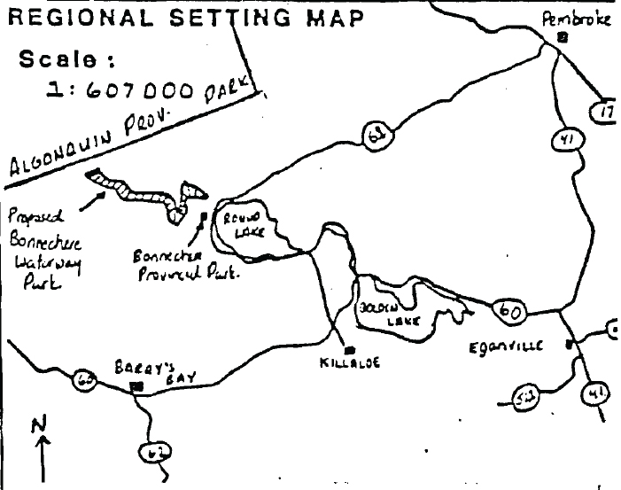
Bonnechere River Provincial Park Regional Setting Map
Targets
1. Life Science Representation
| Site Type/Landscape Unit | Species/Communities |
|---|---|
| Great Lakes-St.Lawrence Forest Region of Canada Humid Eastern Ontario-Georgian Bay |
Formerly white pine forest area now composed of communities of red & silver maple., black ash, red & white pine. White Oak is at its northern limit. |
2. Earth Science Representation
| Geological Theme | Feature |
|---|---|
| Valley part of Ottawa-Bonnechere Graben. Floor is filled with flat lying glacial deposits of outwash and lacustraine sands. Bedrock of Precambrian origin. | Uplands are metamorphic or metasedimentary gneisses, intruded by igneous rocks of felsic and plutonic origin. Uplands rise 1000' above valley floor. |
3. Cultural Resource Representation
| Theme | Theme Segment |
|---|---|
| Historically the area was logged during the square timber era. Last log drive in 1922. Since this time fire has swept the area and it has provided saw logs to area mills. |
4. Recreation Opportunities
| Day Use | Car Camping | Wilderness/Back Country |
|---|---|---|
| N/A | N/A | 2,000 |
Inventories
| Level/Type | Earth Science | Life Science | Cultural | Recreational | Other |
|---|---|---|---|---|---|
| Reconnaissance Completion Date | N/A | No | N/A | ||
| Detailed Completion Date | Speck 1975 | Hanna 1975 | N/A | No | N/A |
| Required? |
Management Consideration
1. Land Tenure
Large amounts of land along the Bonnechere River are patented and have cottage development on them. Several Land Use Permits (LUP's) and Licenses of Occupation (Lic. of Occ.) have been issued for land adjacent to the river. The following lots and concessions border the proposed park and area either fully or partially patented.
Richards Township
| Lot | Concession |
|---|---|
| 28, 28, 24, 35 | IX |
Burns Township
| Lot | Concession |
|---|---|
| 2, 3, 4, 5, 7 | IX |
| 6, 7, 8, 9 | X |
| 10 | XI |
| 13, 14, 15 | XIII |
| 15 | XIV |
The following people have been issued L.U.P.'s or Licenses of Occupation within the Park Boundary.
| Issued To | Location | Designation on Boundary map | Purpose |
|---|---|---|---|
| Boy Scout of Canada | Burns 6, 7, X L.U.P. | 1 | Scout camp & hiking area. |
| Boy Scout of Canada | Burns 7, X Lic. of Occ. | 2 | Two permanent structures for accomodation shelter area. |
| Anthony Nighbor | Richards | 3 | Fishing and hunting camp. |
Guideline:
No further land disposition in any form should occur. The current land use by the holders of L.U.P's and Licenses of Occupation does not interfere with the park objective and as a result, should be allowed to continue now and after park designation. Consideration should be given to removal of Land Use Permits or Licenses of Occupation as the opportunity arises. Co-operation of land holders should be sought prior to parks status designation.
2. Land Acquisition
The Ministry does not have intentions of acquiring additional property for the park within the foreseeable future.
Guideline:
Co-operation of the current patent land holders should be sought prior and subsequent to park designation. Consideration should be given in the interim and beyond to the purchase of any privately held land which becomes available on the open market. Acquisition of private land should only be considered when such acquisition benefits attainment of the park objective. The benefits accrued to the park through land purchase should be weighed against the cost of purchase.
3. Existing or Proposed Development
-
Roads
A road is located along the north shore of the Bonnechere River leading past Basin Depot to the power transmission corridor in Algonquin Park. The road provides access to timber resources in Pembroke and Algonquin Park Districts and passes close by Stevenson Lake and the Couchain Lakes, crossing the park boundary in many places. A similar road is located in on the south side of the river.
Guidelines:
Both of the above mentioned roads are required for forest management and recreational uses and as such, must be maintained throughout this interim period. Use of the two roads should be monitored prior to development of a Park Management Plan to determine what effect their presence will have on the park as a recreation area. - Access Points
Presently there is only one good access point along this part of the Bonnechere River. It is located just west of the junction of Turner’s and Gunns Roads at the eastern end of Beaver Dam Lake. The following facilities are provided at the access point:- Garbage disposal cans
- Boat launch area
- Earth pit toilet
In addition, the area has been posted as a "No Camping" zone.
Guideline:
The present access point should be maintained throughout the interim period of development. Signs indicating that the area is a recommended park should be posted along with guidelines for park use. - Campsites
At the present time, there are no maintained public campsites along this part of the Bonnechere River. There are a few primitive campsites which receive very light use.
Guidelines:
In order to protect the value of the park, use of existing primitive campsites should be monitored. If site degradation begins to occur, consideration should be given to upgrading sites through construction of fire pits and small privies.
4. Recreation Areas
Currently, the Bonnechere River is utilized primarily as a fishing, canoeing, boating and hunting area. No nature trails are as yet located within the park boundary.
Guideline:
Each of the above mentioned uses should be allowed to continue. Ministry guidelines state that once the park has been designated, hunting will continue within its bounds since it will not interfere with the park objective. During the interim phase, the water quality of the river should be maintained and protected with respect to shoreline dredging or filling operations. At this time, the value of the lower Bonnechere River as a canoe route linked to another route leading deep in the Algonquin Park interior should be stressed.
5. Commercial Activities
Several economic activities have historically occurred in the Bonnechere River Valley and continue to do so today. Extensive timber harvesting once occurred within the recommended park and the land adjacent to the river continues to supply wood to area mills. Trapline No. 17 of Richards and Hagarty Township is registered to Reginald Turner while No. 48 of Burns Township is registered to Paul Kohoko. In addition, resident trapping licenses have been issued to K. Eno and F. Turner. Cottage leasing or renting occurs along the river and two commercial bait-fish zones encompass the Bonnerchere River.
Guideline:
During the interim phase no timber harvesting will be allowed. Trapping and bait fishing will be allowed to continue, however notice should be given to those involved that after park designation, neither of these uses will be allowed within the park boundary. In the future, if any trapping is necessary to protect the integrity of the park, Reginald Turner or Paul Kohoko should be contacted. Leasing of privately owned cottages will not be affected by park designation.
6. Natural Resources
Eighty-four hectares of red and white pine plantations occur within the park boundary. These trees range in age from 2 to 22 years, with the bulk of the trees aged 18 - 22. These stands will require thinning sometime in the future. No commercial fishing, wild rice harvesting or mineral prospecting currently occurs in the park.
Guideline:
In the interim period, a vegetation management plan should be devised in order to determine when stand improvement of the plantations should occur.
7. Life Science
The Bonnechere River provides a habitat for the following provincially or regionally rare species:
- The Wood Turtle
- Bristly Greenbrier,
as well as southern species such as cardinal flower, white oak and bur oak.
Guideline:
In the interim phase, these species should be protected in order to enhance the park objective.
8. Client Services
Presently, no services are offered to users of the Bonnechere River, however mention is made in the Bonnechere Provincial Park Brochure of the river canoe route upstream to Algonquin Park.
Guideline:
No direct services will be implemented during the interim phase of development.
Advertising the Bonnechere River Waterway Park A Strategy
Consideration should be given to advertising the Waterway Park as one of "three" Bonnechere’s to choose from, just as Algonquin’s two sides are highlighted in the film "Images of Algonquin".
- The Bonnechere Provincial Park:
A recreational park where families can enjoy camping in a relaxed atmosphere.
- The Foy Property:
A day use area for picnicing and swimming located only 10 km from Bonnechere on Red Rock Road.
- The Bonnechere Waterway Park:
A canoe route which joins the upper Bonnechere River canoe route of Algonquin Park. This park exemplifies a case where cottagers, resource consumers and park planners have compromised and created a situation beneficial to all. A brochure to this effect could be created showing each of the three areas and including a map showing each.
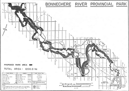
Map of Bonnechere River Provincial Park
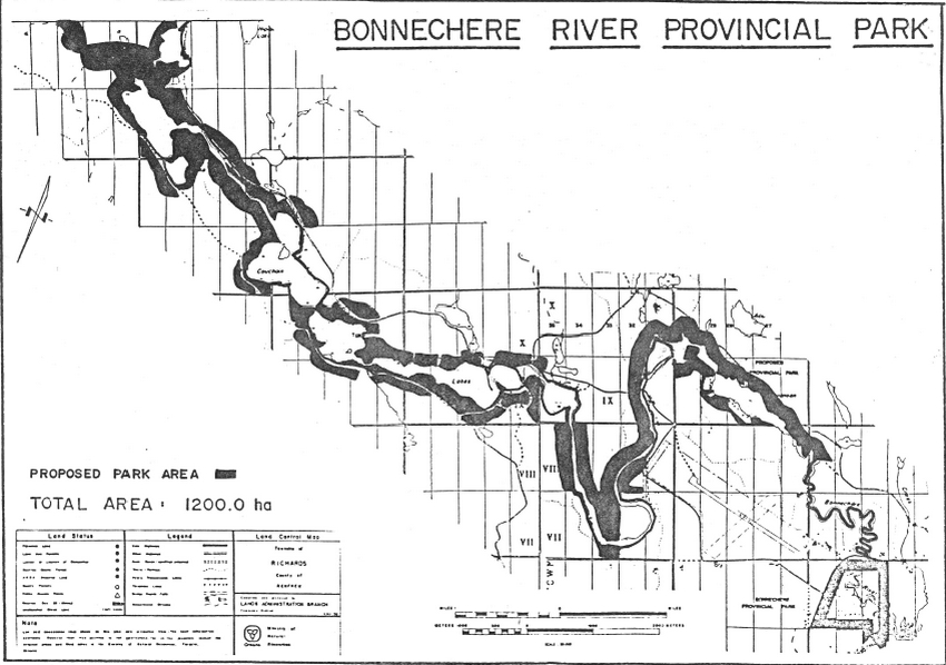
Enlarge Map of Bonnechere River Provincial Park
Sources/References
Ministry of Natural Resources Land Use Guidelines Backgrounder June 1983.
Ministry of Natural Resources Land Use Guidelines Pembroke District 1983.
Ministry of Natural Resources Simpson Bonnechere River Proposal - Life Science Inventory Check-Sheet 1980.
Ministry of Natural Resources Parks and Recreation Constance M. Speck Brief Geomorphology and Geology of the Bonnechere Shady Area, including Bonnechere Provincial Park, Nipissing District and Renfrew County, Ontario 1975.
Ministry of Natural Resources Parks and Recreation Rysa Showkewych - Hanna Preliminary Botanical Inventory of the Bonnechere Shady Area 1975.