Boyne Valley Provincial Park Management Statement
This document provides direction on the management of Boyne Valley Provincial Park.
Interim Management Statement
January 20, 1995
Regional Director’s Approval Statement
This Interim Management Statement will provide interim direction for the management of Boyne Valley Provincial Park until a comprehensive Park Management Plan has been prepared.
This statement will provide the basis for future preparation of the Park Management Plan.
I am pleased to approve this Interim Management Statement for Boyne Valley Provincial Park.
Background Information
Background Information
| Name | Boyne Valley Provincial Park |
|---|---|
| Proposed Class | Natural Environment |
| M.N.R. District | Midhurst |
| M.N.R. Region | Southern Region |
| Total Area (ha) | 431 |
| Land | |
| Water | |
| Site Region | 6E |
| Site District | 6-7 Niagara Escarpment |
| Date in Regulation | O. Reg. 279/85 |
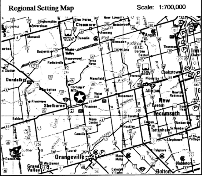
Boyne Valley Provincial Park Regional Setting Map
Targets
1. Life Science Representation
| Site Type/Landscape Unit | Feature |
|---|---|
| Bottomland wetlands (organic substrates) | Conifer & mixed swamp, beaver ponds, minor meadow marshes, major braided stream system. |
| Mesic North facing slopes and ravines | Mixed forest, seepage zones/springs, streams. |
| Dry South facing slopes and ravines | Deciduous forest. |
| Limestone canyons/cliffs | Moist talus rubble, stream thicket and cliff communities. |
| Tableland and bottomland fields (Focus of Boyne Valley Life Science ANSI) |
Agricultural crops & pastures, old field succession, hawthorn thickets, pine plantations. |
2. Earth Science Representation
| Geological Theme | Feature |
|---|---|
| Paleozoic (Niagara Escarpment) - Silurian (Cataract Group) |
Exposures as narrow canyon in SW corner of park and cliffs where Rd. 16 crosses Boyne River. |
| Paleozoic (Niagara Escarpment) - Ordovician (Queenston Formation) |
Underlying bedrock to the east. |
| Pleistocene -(Primrose-Boyne Valley Earth Science ANSI) |
- Major river valley occupying provincially significant Violet Hill Spillway. - Associated, terraced meltwater channel at SE edge (440-445 m ASL) - Orangeville Moraine forms lhe southcentral and northcentral table- lands, with prominent heights of land (505 m ASL) - Rough, bouldery meltwater terrain in western portion of the valley. |
| Holocene | Broad, bottomland organic deposits and braided, beaver-ponded streams in Boyne Valley (390-410m ASL) |
3. Cultural Resources Representation
| Theme | Theme Segment |
|---|---|
| Local significance only | Effects of escarpment on settlement pattern |
4. Recreation Opportunities
| Day Use | Car Camping | Wilderness/Back Country |
|---|---|---|
| Hiking, nature appreciation, fishing, hunting (on non-regulated Crown Land) | Nil | Nil |
Inventories
| Level/Type | Earth Science | Life Science | Cultural | Recreational | Other |
|---|---|---|---|---|---|
| Reconnaissance Completion Date | 1987 | ||||
| Detailed Completion Date | 1991 | 1971,73 | |||
| Required? | detailed |
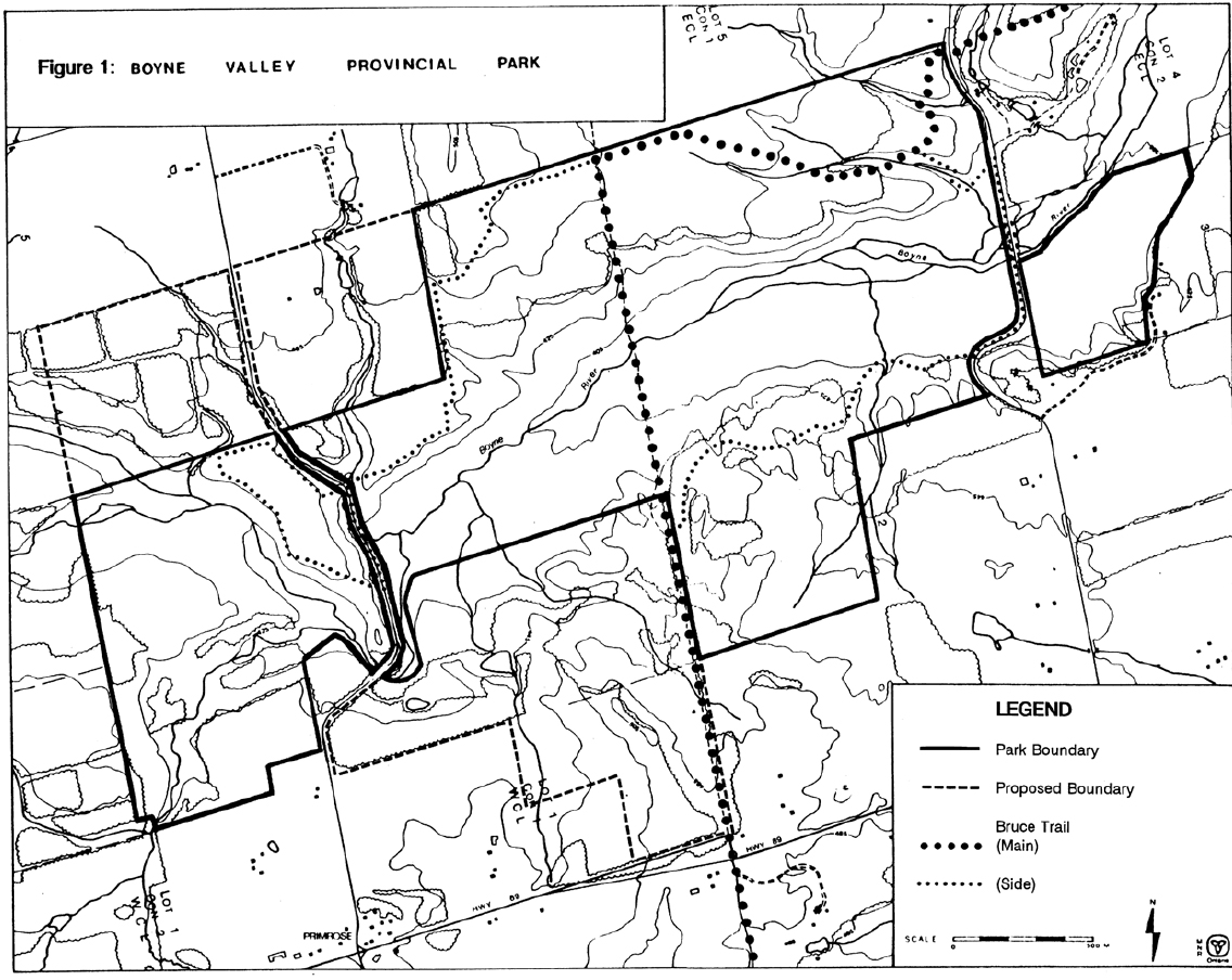
Figure 1: Boyne Valley Provincial Park
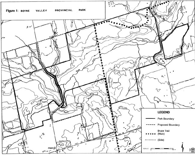
Enlarge Figure 1: Boyne Valley Provincial Park
Management Guidelines
I. Land Tenure
The Ministry presently owns 1,070 hectares of which 431 hectares are regulated under the Provincial Parks Act. The area within park regulation is shown on Figure 1. Several hundred hectares of acquired Crown lands upstream of the regulated park may have potential to be added to the park to protect the Boyne River Valley and the coldwater stream habitat.
Two land use permits, totalling 253 hectares, were issued in 1994 for the purpose of pasture and cash crops. A seasonal recreational (snowmobile) trail land use permit is issued annually to the Dufferin Drift Busters Snowmobile Club.
Guidelines:
Adjacent acquired Crown lands will be considered for possible inclusion in the provincial park or may be declared surplus and disposed of.
An annual reassessment will be carried out to determine whether the agricultural land use permits should be renewed. The seasonal recreational (snowmobile) trail land use permit may be renewed on an annual basis.
II. Land Acquisition and Disposition
Further land acquisition is proposed for:
- Part of Lot 2, Concession 1, West of Hurontario Street (J. Weir property)
- Part of the Hurontario Street road allowance between Concession 1, East of Hurontario Street, and Concession 1, West of Hurontario Street (through Lots 1 through 4)
- Parts of the road allowance between Concessions 1 and 2, West of Hurontario Street, in Lots 2 and 3
- Part of Deviation Road (Instrument No. 12539), West Half of Lot 2, Concession 1, West of Hurontario Street
Guidelines:
A priorized land acquisition list will be submitted to the Ministry’s Niagara Escarpment Coordinator on an annual basis as part of the Niagara Escarpment Land Acquisition and Stewardship Program (NELASP). Newly acquired lands will be regulated as part of the park.
The status of adjacent acquired Crown land will be reviewed and such lands may either be placed into regulation as part of the park or declared surplus and disposed of through sale or land exchange.
III. Existing Development
Existing development on current land holdings include:
- one barn
- one drive shed
- approximately 2 kilometres of the Bruce Trail
- approximately 20 kilometres of snowmobile trail
A small parking area located on the east side of Concession I East of Hurontario Street (EHS) is often used by fisherman to access the stream at this location.
Guideline:
The small parking area adjacent to the road allowance must be monitored for garbage.
IV. Proposed Development
There are no plans for the development of the provincial park in the next five to ten years. Most of the proposals of the park master plan prepared by M.M. Dillon Limited and D.W. Graham and Associates Limited in 1975 are no longer considered to be relevant in the context of current recreational demands and funding constraints.
The park areas falls entirely within the Niagara Escarpment Planning Area and also within the area which is subject to development control by the Niagara Escarpment Commission.
Guidelines:
Prior to any major development, a park management plan will be prepared with full public consultation.
On an interim basis it would be desirable to establish a public access point with a small parking lot, vault privies and picnic tables. The preferred location is on the east side of Prince of Wales Road on Lot 4, Concession 1 West of Hurontario Street (WHS).
V. Recreation Activities
The property is used extensively by hikers, cyclists, cross-county skiers, snowmobilers, trail bike and all-terrain vehicle riders. Some fishing for brook, brown and rainbow trout occurs along the Boyne river. Small game hunting occurs on the adjacent Crown lands.
Some park resources (i.e. historical and life science features) are sensitive to damage. A detailed life science inventory is required to evaluate the appropriate recreational uses of the property.
The Bruce Trail passes through the park. A side trail (Primrose Loop) provides access to an excellent lookout.
The park is used extensively by the City of Toronto Board of Education for outdoor education activities. The board operates an outdoor education centre in the northeast corner of the property.
Guidelines:
The Dufferin Hi-Land Bruce Trail Club will continue to maintain the hiking trail through the area.
The Dufferin Drift Busters Snowmobile Club will continue to maintain the snowmobile trail through the area.
In consultation with local trail groups and park users, a study of existing formal and informal trails should be carried out. Subsequently, a trail implementation plan should be prepared which would rationalize the trail network based on a consideration of environmental suitability, public safety, user compatibility, provincial park policy, and other available technical resources.
Undesirable trail uses will be prohibited. Signage and enforcement will be applied as required.
A memorandum of understanding should be signed with the Toronto Board of Education which would define their use of the park property, including any limits which should be set in order to protect sensitive areas.
VI. Natural Resource Management
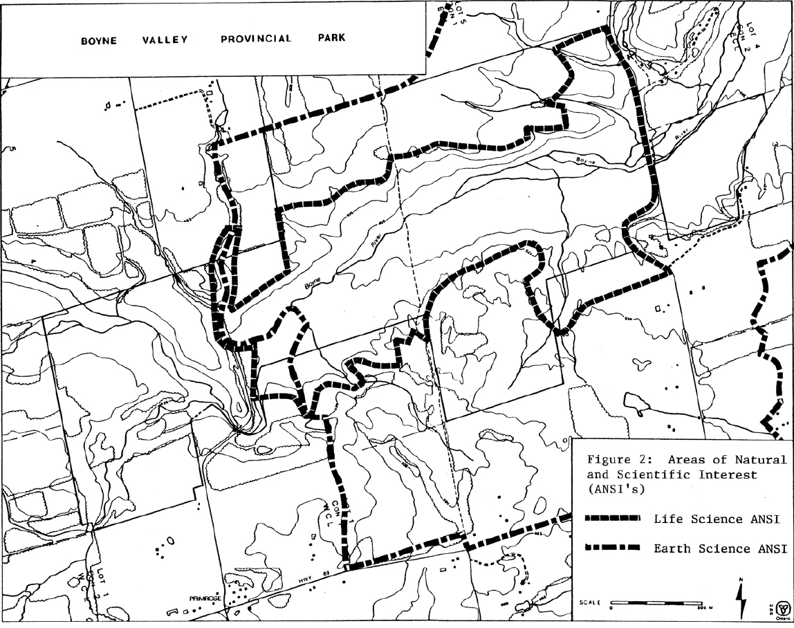
The provincial park and adjacent areas contain provincially significant areas of natural and scientific interest (ANSI's), namely the Boyne Valley Life Science ANSI and the Primrose-Boyne Valley Earth Science ANSI, as shown on Figure 2.
Land and Water Management Guidelines:
The existing trail system may be modified and improved by completion of a trails assessment and proper marking of the trail system.
Undesirable trail uses may be prohibited by signage and enforcement, including the use of the property by trail bikes and all-terrain vehicles. Much of the unauthorized use occurs on the existing road allowances that are not included as park property.
Agricultural land use will continue by rental agreement until the end use of the property is determined in the park management planning process.
Surveillance and garbage clean-up should be performed on a regular basis.
Improved signage is required on the property to encourage permitted used and discourage abuse of the property.
Improvements to public access, vault privies and picnic tables will be considered to accommodate existing use if funding is available for development and operation.
Fauna Management Guidelines:
Sport fishing will be allowed to continue.
Commercial trapping will not be permitted within the provincial park. Trapping of nuisance animals will be permitted as a resource management technique.
Hunting will not be permitted within the provincial park.
VII. Marketing
Guideline:
Until a management plan is prepared and priorities are set regarding development of the property, no plan has been suggested to promote the park other than general information available through Earl Rowe Provincial Park or the Midhurst Parks Zone Office.
Figure 2: Areas of Natural and Scientific Interest

Enlarge Figure 2: Areas of Natural and Scientific Interest
VIII. Research
Numerous reports were prepared between 1973 and 1975 during the preparation of the first park management plan.
Reviewing the park management plan and completing an assessment of existing and proposed trail systems are the priority projects for this property.
Guidelines:
A detailed life science inventory and evaluation may be completed prior to preparation of a park management plan.
A trail plan may be completed prior to the preparation of a park management plan.
IX. References
Beechey, T.J. and A.G. Tracey. Primrose Provincial Park Reserve: Environmental Planning Series Miscellaneous Report - An Environmental Impact Study. Toronto, Ontario Ministry of Natural Resources, Park Planning Branch, 1973.
Bingham, D.A. Proposed Park at Primrose - A History. Earl Rowe Provincial Park, 1973.
Bishop, Fred. Interpretive Directional Planning for Primrose Provincial Park. Ontario Ministry of Natural Resources, 1973.
Bruce Trail Association. Bruce Trail Reference, 19th Edition. Hamilton, 1994.
Clayton Research Association. Market Analysis. 1973.
Comments on Specific Areas of the Primrose Property. 1971.
Greenland, Gary. Brief Historical Inventory of Primrose Park Reserve. Ontario Ministry of Natural Resources, Historical Sites Branch, Planning: Research, 1973.
Harris, A., R. Ritchie and M. Stabb. A Preliminary Life Science Survey. Mulmur Township, Dufferin County, Boyne River Natural Science School, 1987.
Hulme, F.G. and Brian H. Jackson. Primrose, Mono Cliffs, Scott’s Falls and Credit Forks Recreation Areas Descriptive Report.1973.
J. Ross Raymond and Associates Limited Amendment Number 7 to the Official Plan of the Mulmur Planning Area.The Mulmur Planning Board, 1985.
J. Ross Raymond and Associates Limited Official Plan of the Mulmur Planning Area.The Mulmur Planning Board, 1973.
Kor, P.S.G. An Earth Science Inventory and Analysis of the Violet Hill Channel - Boyne Valley Area of Natural and Scientific Interest and Boyne Valley Provincial Park. Aurora, Ontario Ministry of Natural Resources, 1991.
Kovacevic, Darija. Historical Architectural Study of Proposed Provincial Park at Primrose. Primrose, 1973.
Marshall, Macklin, Monaghan. Proposal for Primrose Provincial Park. 1973.
M.M. Dillon Limited, D.W. Graham and Associates Limited. Boyne Valley Provincial Park Master Plan.Toronto, 1975.
M.M. Dillon Limited. Primrose Park Traffic Study. Toronto, 1974.
Niagara Escarpment Commission. The Niagara Escarpment Plan. Ontario Ministry of Environment and Energy, Toronto, 1994.
Ontario Ministry of Natural Resources. Huronia District Land Use Guidelines. Midhurst, 1983.
Ontario Ministry of Natural Resources. Ontario Provincial Parks Planning and Management Policies. Toronto, 1978.
Ontario Ministry of Natural Resources. Ontario Provincial Parks Planning and Management Policies - Update. Toronto, 1992.
Patten, Bruce. Geological Summary and Groundwater of Primrose Park.
Sadler, D. The Park Story - Primrose Provincial Park. Primrose, 1971.
Tracey, A.G. Brief Notes on the Geomorphology of Primrose and Adjacent Area. Toronto, Department of Lands and Forests, Parks and Recreation Branch, 1971.
Treacy, John F. Geological Report for Primrose Park. Maple, Ontario Ministry of Natural Resources, 1973.