Butler Lake Provincial Park Management Statement
This document provides direction on the management of Butler Lake Provincial Park.
Interim Management Statement
© 1985 Government of Ontario
Additional copies of this publication are available from the Dryden District Office, P.O. Box 730, Dryden, Ontario P8N 2Z4
January, 1986
Regional Director’s approval statement
This Interim Management Statement will provide interim direction for the management of the Butler Lake Provincial Nature Reserve until a comprehensive Park Management Plan is prepared.
This statement will provide the basis for the subsequent preparation of the Park Management Plan.
I am pleased to approve this Interim Management Statement for the Butler Lake Provincial Nature Reserve.
Signed by:
D.R. Johnston
Regional Director
Northwestern Region
Introduction
The purpose of this Interim Management Statement is to identify:
- park values which are to be protected
- resource management prescriptions necessary to protect these values
- restrictions on use of natural resources within the park
This Interim Management Statement is not intended to replace a Park Management Plan. Rather it is intended to guide the use of natural resources and related activities within the park until such a time as a Park Management Plan is prepared.
The guidelines that have been developed are based on information contained in the Dryden District Land Use Guidelines.
Background information
| Name: | Butler Lake |
|---|---|
| Proposed Class: | Nature Reserve |
| MNR District: | Dryden |
| MNR Region: | Northwestern |
| Total Area (ha): | 3400 |
| Land: | |
| Water: | |
| Site Region | 4S |
| Site District | 4 |
| Date in Regulation: | 85.01.24 |
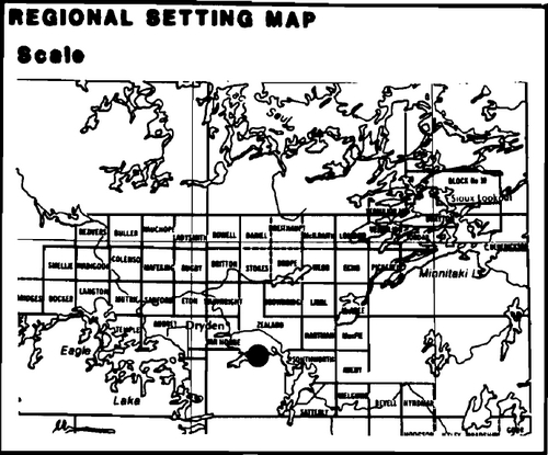
Regional Setting Map:
Targets
Life science representation
| site type / landscape | species / communities |
|---|---|
| Gently rolling clay over bedrock topography and is considered to be representative of Landscape Unit 29 - Dryden Clay Plain. | Closed mixed stands with poplar, white birch, white spruce and balsam on circummesic sites. On the bedrock knolls there are small stands of jackpine & black spruce. |
Earth science representation
| geological theme | feature |
|---|---|
| Representative of glacial Lake Agassiz basin including typical topography deposits. | Excellent representation of significiant red varved clay maker horizon as well as massive to varved grey clay representing deeper portions of glacial Lake Agassiz |
Cultural resources representation
| theme | theme segment |
|---|---|
| N/A | N/A |
Recreation opportunities
| day use | car camping | wilderness/back country |
|---|---|---|
| N/A | N/A | N/A |
Inventories
| level / type | earth science | life science | cultural | recreational | other |
|---|---|---|---|---|---|
| reconnaissance completion date | 1980 | 1981 | N/A | N/A | |
| detail completion date | N/A | N/A | |||
| required? | yes | yes | N/A | N/A |
Management guidelines
I Land tenure/land acquisition/disposal
At present, the park area is comprised entirely of Crown land.
Guideline
The sale or disposal of Crown lands will not be entertained pending the completion of a park management plan.
II Existing/proposed development
There is no existing development within the park boundary at this time.
There are no access roads into the park area and use of the area is relatively light, consisting primarily of trapping, bunting and mineral exploration.
Guideline
Road access will not be permitted within the park boundary.
Proposals for new development will not be considered pending the completion of the park management plan.
III Recreation activities
Recreation activities such as sport hunting and wildlife viewing presently occur within the park area. There are presently no boat caches within the park.
Guideline
Regulations to permit hunting will be implemented when the park is brought into regulation under the Provincial Parks Act.
Unstructured Crown land Recreation activities such as camping, picnicking, berry picking etc. will be permitted to continue.
Cottaging, public access points and/or facilities will not be permitted within the park area.
Resource user and resident boat caches will not be permitted pending the completion of a park management plan.
IV Commercial activities
There are no commercial tourist operations located within the park area.
There is commercial fishing on waters which border on the park area, i.e. Wabigoon Lake, Butler Lake.
Portions of 2 traplines, DR20 and DR21 are located within the park boundary. This involves two non-Native trappers and two non-Native helpers.
Bait fishing is of a low or nil potential within the park area.
The park area is located within the Great Lakes Forest Products licence area.
The Wabigoon Indian Band harvests wild rice from the creek draining Butler Lake into Wabigoon Lake.
Mineral exploration/extraction activity is relatively insignificant within the park area.
There are no commercial boat caches within the park area.
Guidelines
No commercial development, agriculture, commercial bai fishing, wild rice harvesting, tourism, aggregate extraction, commercial fishing, forestry, roads, or other developments of a rural or residential nature will be allowed within the park area as indicated within the Dryden District Land Use Guidelines. An Order-in-Council will be prepared to formally withdraw the park area from the above licence area.
It is recommended that trapping be permitted to continue, but no new trapline cabins are to be erected pending completion of a park management plan. Regulations to permit trapping will be implemented when the park area is brought into regulation under the Provincial Parks Act.
Mineral exploration/extraction will be permitted to continue subject to the conditions of an Exploratory Licence of Occupation (Section 190, R.S.O. of the Mining Act). Mineral exploration will be undertaken in such a way that does not conflict with future management options for the park or the protection of park values.
Commercial boat caches will not be permitted within the park area.
V Natural resources
Guideline
Natural fires will be allowed to burn undisturbed unless they threaten human life, lands outside the park, or values for which the park was established. Fires resulting from human causes will be suppressed. Fire suppression techniques used will have as minimal effect as possible on the park environment. Such means of suppression as bulldozing, and water bombing with chemical additives, will not be permitted except in critical situations.
Management of Wildlife will be directed to the maintenance of an evolving natural succession, unless alternative strategies are desirable.
Management of Vegetation will be directed to the maintenance of an evolving natural succession, unless alternative strategies are desirable.
VI Native interests
There are no known Native interests or claims within the park area.
VII Cultural resources
Guideline
There are no known cultural resources within the park area.
VIII Research
More complete (detailed) earth and life science inventories will be necessary prior to the preparation of a park management plan.
Sources/references
Davis, J.C., 1964 - Manitou Lake Sheet, Districts of Kenora and Rainy River, Ontario Department of Mines, Preliminary Geological Map #P242, Geological Comp. Ger., Scale 1 inch = 2 miles
Kor, P., 1980 - Earth Science Inventory, Checklist and Report
O.M.N.R., 1983 - Dryden District Land Use Guidelines
O.M.N.R., 1980- Report of the Task Force on Parks System Planning
Rittenhouse, G., 1934- A Laboratory Study of an Unusual Servies of Varved Clays from Northern Ontario. American Journal of Science, V28, No. 164, pg. 110-120
Satterly, J., 1941 - Geology of the Dryden -Wabigoon Area
Ontario Department of Mines 30th Annual Report, Volume 1, Part D, Pg. 1-67
Thacker, B., 1981- Life Science Inventory, Checklist and Report
Zoltai, S.C., 1963- Glacial Features of the Canadian Lakehead Area, Can. Geog., V7, No. 3, pg. 101-115
Zoltai, S.C., 1965- Glacial Features of the Quetico Nipigon Area, Ont., J. Earth Sc. V2, pg. 247-269
Zoltai, S.C., 1961 - Glacial History of Northwestern Ontario Proc. Geol. Assoc., Can. V13, pg. 61-83
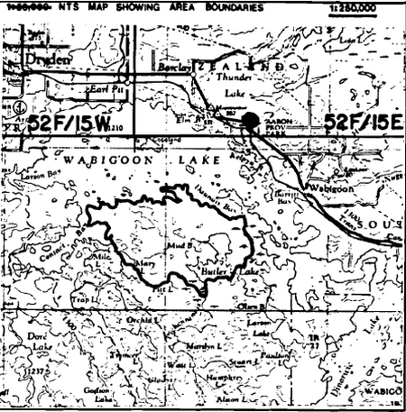
Map: Wabigoon 52F/10
Butler Lake
This area is being recommended for park status.
The candidate park will provide for representation of the Dryden Clay Plain landscape unit.
Given the variety of uses that are ongoing within this area, it is further recommended that most of the ongoing activities within the area be permitted to continue. The exception to this would be commercial logging which is not recommended as a continuing use. An outline of those ongoing activities which are recommended for continuation is given in the Land Use Activity section, however it must be realized that in some instances further refinement may be required.
- Area Description:
Located on the south shore of Wabigoon Lake, the area is primarily used for trapping, hunting and mineral exploration. The area is comprised entirely of land, there are no waterbodies within this area. The area lies in the Great Lakes Forest Products licence area. The area is not currently accessed by road and use of the area is relatively light. This area is approximately 3300 hectares in size. - Land Use Intent:
- Land Use Activity For Area No. 8 - Butler Lake Area
| Activity | Acceptable? | Recommended Guidelines |
|---|---|---|
| Aggregate Extraction | No | |
| Agriculture | No | |
| Bait Fishing | No | |
| Commercial Fishing | No | |
| Cottaging | No | |
| Forestry | No | |
| Hunting | Yes | It is recommended that hunting be permitted to continue. |
| Mining | Yes | It is recommended that mineral exploration! extraction be permitted. |
| Provincial Parks | Yes | This area is recommended for park status. |
| Roads | No | |
| Rural Residential | No | Will not be a permitted use. |
| Sport Fishing | Not applicable. | |
| Tourism | No | |
| Trapping | Yes | It is recommended that existing trapping activity be permitted to continue. |
| Wildlife Viewing | Yes | |
| Wild Rice Harvesting | No | |
| Urban Development | No |
Ontario Nature Reserves Program - Life Science Inventory Checksheet
| Name | Butler Lake (Wabigoon Lake) |
|---|---|
| Map Name | Wabigoon |
| Map Number | 52F/10 |
| UTM Reference | 200060 |
| County, District or Regional Municipality | District of Kenora |
| Latitude | 49° 42' N |
| Longitude | 92° 43' W |
| Altitude Minimum | 366 m (1135 feet) |
| Altitude Maxium | 410 m (1270 feet) |
| Locality | |
| Township | Unsurveyed |
| Lots | |
| Concessions | |
| Area | 9260 acres / 3750 ha |
| Ownership | Crown |
| Administration | |
| Forest Region and District | Boreal-Lower English River |
| Site Region and District | 4S-4 |
| MNR Region and District | NWR - Dryden |
| Conservation Authority | |
| Aerial Photographs (Year/Roll/Flight Line/Numbers) | 1965/19/4928/222-24 1965/48/4929/76-83 1965/48/4930/13-18 |
| Physical and Biological Features | Gently rolling clay over bedrock topography. Up to 8 m massive to varved grey clay representing deeper portions of glacial lake Agassiz. Vegetation is closed mixed stands with poplar, white birch, white spruce and balsam on circum-mesic sites. Small stands of red pine are found-on well-drained shoreline sites and occasionally black ash at back of bays. Jack pine/black spruce found on occasional bedrock knoll. |
| Data Sheet Attached | |
| Major Information Sources | |
| Evaluation and Priorities | This area is an excellent candidate for representing this clay biophysiographic unit. |
| Date Complied | 1981.01.08 |
| Compiler | B. Thacker |
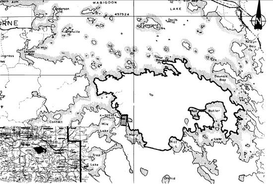
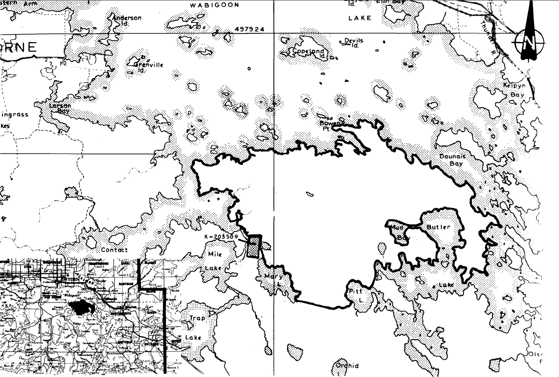
Map: Wabigoon Lake Boundaries
Ontario Ministry of Natural Resources, Division of Parks, Park Planning Branch, Queen’s Park, Toronto, Ontario M7A 1W3
Map: Butler Lake Peninsula Canditate Area
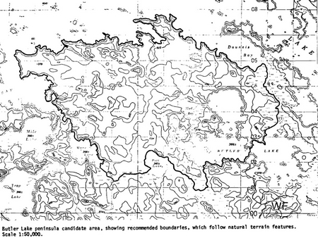
Enlarge Map: Butler Lake Peninsula Canditate Area
Field Notes
Field No.: 9-3 NWR
Date: 1980.09.10
Area Name: Wabigoon Lk. B1
Location: 52F/10 (Wabigoon), 156054
Feature: mature forest on clay
Abiotic Components:
- Slope - level, top of eroding bank
- Aspect - southerly
- Microclimate - normal
- Drainage - fair to good, internal
- Substrate - grey clay
Biotic Components - Vegetation composition by stratum:
- Tree - mature mixed closed forest - Po, Sw, B, Bw, Ce.
- Shrub - Cornus stolonifera. Lonicera canadensis. Rosa acicularis.
- Herb - Aster macrophyllus. Aralia nudicaulis. Fragariavirginiana. Maianthemum canadense. Mitella nuda. Pteridium aquilinum. Petasites frigidus. Linnaea borealis. Rubus pubescens. Cornus canadensis.
- Bryoid -
Faunal Notes - Red Squirrel, White-Throated Sparrow, Red-Breasted Nuthatch.
Incidental Notes -
Field No.: 9-4 NWR
Date: 1980.09.10
Area Name: Wabigoon Lk. B3
Location: 52F/10 (Wabigoon Lk.), 153061
Feature: small red pine stand
Abiotic Components:
- Slope - level point, top of eroding bank
- Aspect - westerly
- Microclimate -normal to warmer than normal
- Drainage - good, internal
- Substrate - grey clay
Biotic Components - Vegetation Composition By Stratum:
- Tree - mature red pine, young red pine, Ce, B, v. occasional white pine
- Shrub - Rosa acicularis, B, Ce
- Herb - Arctostaphylos uva-ursi, Linnaea borealis, Aster macrophyllus
- Bryoid -
Faunal Notes - White-breasted Nuthatch
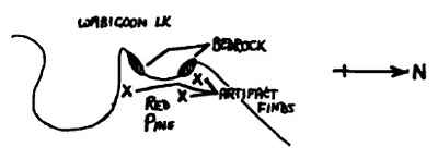
Incidenal Notes - archaeological site
Map: Archaelogical site
Field No.: 9-5 NWR
Date: 1980.09.10
Area Name: Wabigoon Lk. B-5
Location: 52F/10 166062
Feature: Bedrock Knoll
Abiotic Components:
- Microclimate - Warmer than Normal
- Slope - Gently - Moderately Broken
- Drainage - Severe, External
- Substrate - Metavolcanic Bedrock
- Aspect -
Biotic Components - Vegetation Composition by Stratum:
- Tree -B, Sw, Pj
- Shrub - Juniperus communis, Diervilla lonicera, Rhus glabra, Rosa acicularis, Ribes triste
- Herb - Fragaria virginiana, Aster sp., Solidago sp., Anaphalis margaritacea, Corydalis sempervirens, Woodsia ilvensis, Arctostaphylos uva-ursi
- Bryoid - Boreal Chickadee, Evening Grosbeaks Imm. Bald Eagle and Mat. Osprey Flying Over Lake
Faunal Notes -
Incidental Notes:
General note on vegetation for area - Forest is mixed spruce/poplar with occassional white and red pine along shore. A stand of black ash also noted at back of bay. Chenopodium capitatum on clay and Rhus glabra on rock along shore.
Ontario Nature Reserves Program - Earth Science Inventory Checksheet
| Name | Butler Lake Peninsula |
|---|---|
| Map Name | Wabigoon |
| Map Number | 52F/10 |
| UTM Reference | 200060 |
| County | |
| Latitude | 49° 42' |
| Longitude | 92° 43' |
| Altitude Minimum | 366 m (1135 feet) |
| Altitude Maxium | 410 m (1270 feet) |
| Township | Unsurveyed |
| Lot / Concession | A large main peninsula on S. shore of Wabigoon L., S. boundary Mary L., Pitt L., Butler L.; 10 km SE Dryden |
| Area | roughly 9260 acres / 3750 ha |
| Ownership | Crown |
| Administration | |
| MNR Region and District | NWR - Dryden |
| Conservation Authority | |
| Aerial Photographs (Year/Roll/Flight Line/Numbers) | 1965/19/4928/222-24 1965/48/4929/76-83 1965/48/4930/13-18 |
| Earth Science Features | Gently rolling clay over bedrock topography. Up to 8 m massive to varved grey clay representing deeper portions of glacial Lake Agassiz; at least 11 red varves area an important maker horizon |
| Sensitivity | Sensitive to bank (clay) erosin throughout the area |
| Significance |
|
| Major References | Rittenhouse 1934 Zoltai 1961 |
| Date Complied | 21 October 1980 |
| Compiler | P. Kor |
Physical features:
field work 10 Sept. 1980; flight 17 Sept. 1980
A low, gently hummocky terrain characterizes the large peninsula along the south shore of Wabigoon Lake. Low knolls of bedrock, often steep sided and bare to thinly mantled by sandy soils, are interspersed with numerous wetland depressions. Drainage is relatively poor due to the bedrock or clay substrate, resulting 1n few streams on the peninsula.
The bedrock consists predominantly of basaltic to andesitic metavolcanic rocks lying within the Wabigoon Subprovince, Superior Province, Canadian Precambrian Shield. Satterly (1941, p.31) indicates that there rocks represent a steeply dipping to vertical intercalated volcanic sequence. The over 8000 m (25000 ft.)(Satterly, 1941, p.31) thick sequence of volcanic rocks face north, as is indicated by excellent exposures of pillow lavas throughout the area. Relatively undefonned pillows are well exposed on the shore (52F10 UTM 193067) near Bowen Pt. and on two small islands (52F10, UTM's 258068 and 270041) at the east end of the candidate Satterly, 1941, p.10). Some rhyolitic metavolcanic rocks and acid intrusive rocks are also reported (Davies,1964; Satterly,1941). Exposures are generally poor,consisting of glacially smoothed shoreline outcrops or lichen-covered knolls. Well-developed glacial striae on shoreline outcrops generally indicate a north-south ice movement, Erratic boulders commonly occur on the bedrock surface at the base of the clay banks.
The candidate area contains significant deposits of lacustrine clays related to glacial Lake Agassiz. Massive grey clays occur throughout the area,.asking all but the higher bedrock knolls. Wave-cut shoreline exposures reveal exceptional sections of varved clays. Interbedded or overlying the clays are coarser deposits of clayey silt and stony, clayey sand, probably the result of a shallowing of the lacustrine environment.
Varved clays are characteristic of the Wabigoon River basin, one of the major containment basins of glacial Lake Agassiz. The average thickness of the varved clay deposits is about 3 m (10 ft), varying locally up to 8 m (25 ft.)(Zoltai, 1961, p. 71). Both extremes were noted in the candidate area, with 8 m banks exposed in the northwestern portion. The thickness of individual varves varies greatly, but generally decreases towards the top of a section. A couplet thickness of up to 2 cm is common, typically with a thicker grey-brown lower member and a thin white to light brown upper member. The number of varved couplets in the deposits is not known, though over a hundred were noted from the candidate area. Rittenhouse (1934, p. 110) examined sections containing up to 850 varves in the Wabigoon River valley to the east.
In contrast to the usual grey varved clays described above, a distinct band of red varved clays occurs within the Wabigoon River basin (Zoltai, 1961, p. 72). Normally covered by up to 2 m of grey clay, the red band commonly occurs at the top of a section, probably the result of erosion of the overlying deposit. The band of red clay attains a thickness of 60 cm in the eastern part of the basin, gradually thinning towards the west, consisting of 15 to 24 varves (Zoltai, 1961, p. 74). Within the candidate area, 11 distinctly red varves attain a maximum observed thickness of about 40 cm. The lower contact of the red band is distinct, with the fourth varved couplet from the bottom consistently the thickest set, it having a maximum thickness of 2 cm. The upper boundary with the grey clay is less distinct, making it difficult to accurately count the number of red varve couplets.
Concretions are common in the clays (Satterly, 1941, p. 44). As wave erosion removes the fine bank material, these concretions are often left behind to form a shingle-type beach deposit. The concretions vary greatly in size and shape.
The majority of the massive and varved clays were deposited in glacial Lake Agassiz during a stage (early Campbell) when the ice stood at the Hartman Moraine system. The red band of varved clay was introduced when the Kashabowie-Seine and Firesteel spillways (Zoltai, 1965, p. 265) drained glacial Lake Kaministikwia westward into glacial Lake Agassiz. The iron-rich calcareous red clay member of the varved couplets is characteristic of this eastern lake (Zoltai, 1963, p. 111). Rittenhouse (1934) describes in detail the red clay band in the Wabigoon River basin.
Significance:
The Butler Lake peninsula candidate represents the glacial Lake Agassiz basin in terms of topography and deposits. The varved clays are extremely well-exposed in lakeshore bluffs which are kept vertical by wave-action. The band of red varved clay, which serves as a distinct marker horizon and a discrete time interval during glacial Lake Agassiz deposition, is also well-developed and well-exposed. The candidate area is relatively isolated on the south shore of Wabigoon Lake, and for this reason has remained undisturbed. As the candidate lies adjacent to Wabigoon Lake, the centre of the Wabigoon River basin, the clays found within the candidate represent some of the deepest deposits of glacial Lake Agassiz.
Recommendations:
It is strongly recommended that the Butler Lake peninsula candidate be established within the parks system as a Provincial Nature Reserve.
References:
Davies, J.C., 1964. Manitou Lakes Sheet, Districts of Kenora and Rainy River. Ont. Dep't. Mines, Prelim. Geol. Map No. P 242, Geol. Comp. Ser., Scale 1 in. = 2 mi.
Rittenhouse, G., 1934. A Laboratory Study of an Unusual Series of Varved Clays from Northern Ontario. Am. J. Sci., V. 28, no. 164, 110-120.
Satterly, J., 1941. Geology of the Dryden-Wabigoon Area. Ont. Dep't. Mines, 50th Ann. Rep't., Vol. L, pt. II, p. 1-67.
Zoltai, s. C., 1961. Glacial History of Part of Northwestern Ontario Proc. Geol. Assoc. Can., V. 13, p. 61-83.
Zoltai, S.C., 1963. Glacial Features of the Canadian Lakehead Area. Canadian Geographer, V. 7, no. 3, p. 101-115.
Zoltai, S.C., 1965. Glacial Features of the Quetico-Nipigon Area, Ontario. Can, Journal Earth and Science, V. 2, p. 247-269.
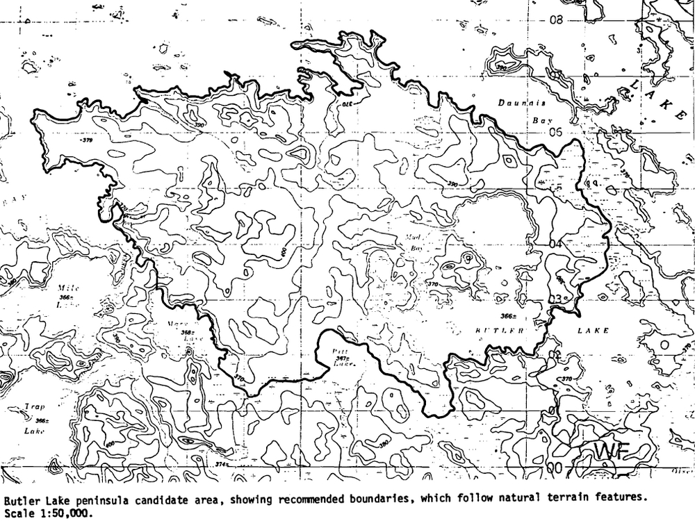
Map: Butler Lake peninsula canditate area
Enlarge Map: Butler Lake peninsula canditate area
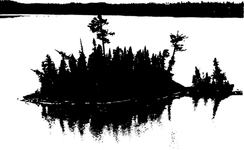
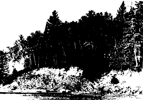
Typical shoreline of glaciated bedrock overlain by boulders (at base) and wave-cut banks of silt and clay. This is also a minor achaeological site. UTM 153061.
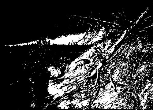
Section of wave-cut clay bank, exposing gray-whitevarve couplets and showing distinct, thickly banded red-white varve couplets probably introduced from the east. Pen-knife for scale. UTM 162065.
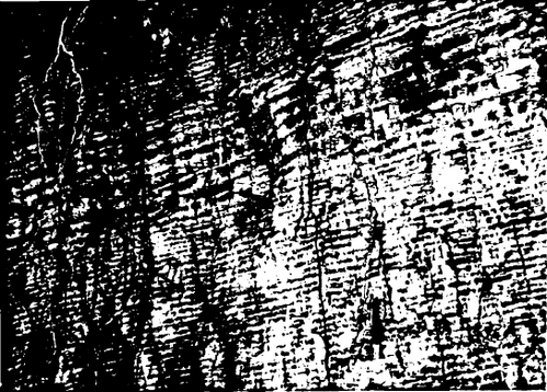
Typical bank exposure, showing glacially smoothed bedrock, large boulders resting on bedrock, and slumped clay bank. UTM 157053.
Small island showing typical low-water exposure. Erosion will probably eventually destroy this and similar islands. UTM 160053.