Caliper Lake Provincial Park Plan
This document provides policy direction for the protection, development and management of Caliper Lake Provincial Park.
Approval statement
I am pleased to approve the Caliper Lake Provincial Park Management Plan as the official policy for the management of this protected area. The plan reflects the intent of the Ministry of Natural Resources and Forestry, Ontario Parks to protect the natural values and cultural heritage resources of Caliper Lake Provincial Park and to maintain and develop opportunities for high quality ecologically sustainable outdoor recreation experiences and heritage appreciation for the residents of Ontario and visitors to the province.
This document outlines the site objectives, policies, actions and implementation priorities, related to managing the park’s natural, cultural and recreational values, and summarizes the involvement of Indigenous communities, the public and stakeholders that occurred as part of the planning process.
The plan for Caliper Lake Provincial Park will be used to guide the management of the park over the next 20 years. During that time, the management plan may be examined to address emerging issues or changing conditions, and may be adjusted as the need arises.
I wish to extend my sincere thanks to all those who participated in the planning process.
Bruce Bateman
Director, Ontario Parks
17 November, 2016
Executive summary
Caliper Lake Provincial Park is a 147 hectare recreation class park. The park is located between the city of Fort Frances and the community of Sioux Narrows-Nestor Falls on Highway 71.
Caliper Lake Provincial Park is located among the traditional lands and waters of several Indigenous communities where individuals continue to hunt, trap, fish, gather and travel in the area.
Caliper Lake Provincial Park is best known for its camping and daily use which is nestled in a picturesque forest of mature pine trees. Caliper Lake Provincial Park makes a significant contribution to the provincial parks system. The park has long been recognized as a destination for recreation, and a natural area with unique biophysical and cultural attributes.
While not fully aware of Indigenous interests in the area, given the number of communities and archaeological features of the surrounding landscape, Ontario Parks recognize, respect and value interests that Indigenous communities may have. Respect and protection of archaeological and cultural heritage features are integral to this park management plan.
The Provincial Parks and Conservation Reserves Act, 2006 guides the planning and management of protected areas in Ontario. Two specific principles of this legislation guide all aspects of planning and management of provincial parks and conservation reserves:
Maintaining ecological integrity is the first priority and the restoration of ecological integrity is considered.
Opportunities for consultation are offered.
The Caliper Lake park management plan was developed in accordance with the Provincial Parks and Conservation Reserves Act, 2006, Provincial Parks Planning and Management Policies (1992 Update) and Ontario’s Living Legacy Land Strategy (1999).
This document has also been prepared in accordance with guidelines set out in Protecting biodiversity for the future: Ontario’s Biodiversity Strategy (2005) and in the Protected Areas Planning Manual (OMNRF 2015a).
Key management direction for the park includes:
- Industrial development such as logging and mining are prohibited;
- Hunting is not permitted;
- Snowmobiles and ATVs are not allowed in the park;
- Recreational boating is permitted except in designated swimming areas; and,
- Backcountry camping is not permitted.
The management plan will guide the management, operation and development of the park over the next twenty years. It can be revised and amended as necessary, in consultation with Indigenous communities, stakeholders and the public.
Résumé
Le parc provincial Caliper Lake, de 147 ha, est classé dans la catégorie « parc de loisirs ». Le parc est situé entre la ville de Fort Frances et le hameau de Sioux Narrows-Nestor Falls sur la route 71.
Le parc provincial Caliper Lake chevauche les terres et eaux traditionnelles des communautés autochtones qui y chassent, posent des pièges, pêchent, se regroupent et voyagent.
Le parc Provincial Caliper Lake est surtout connu pour sa zone de camping et d'utilisation de jour, nichée dans une forêt de pins matures pittoresque. Le parc apporte une contribution importante au réseau des parcs provinciaux. Il a longtemps été reconnu comme une destination importante pour les loisirs et une zone naturelle importante avec des attributs biophysiques et culturels uniques.
Conscient des caractéristiques archéologiques autochtones situées dans la région, Parcs Ontario apportera une attention spéciale aux intérêts particuliers des Premières Nations locales. Le respect et la protection des caractéristiques archéologiques et culturelles font partie intégrante de ce plan de gestion du parc.
La Loi de 2006 sur les parcs provinciaux et les réserves de conservation guide la planification et la gestion du réseau des zones protégées en l'Ontario. Deux des principes de cette loi régissent tous les aspects de la planification et de la gestion du réseau des parcs provinciaux et des réserves de conservation :
Le maintien de l'intégrité écologique est la priorité principale et le rétablissement de l'intégrité écologique est pris en considération.
Des possibilités de consultation sont offertes.
Le plan de gestion du parc Caliper Lake a été préparé conformément à la Loi de 2006 sur les parcs provinciaux et les réserves de conservation, aux politiques de gestion et de planification relatives aux parcs provinciaux de l'Ontario (dans leur version mise à jour en 1992) et à la Stratégie d'aménagement du territoire du Patrimoine vital de l'Ontario (1999).
Ce document a aussi été préparé conformément aux orientations exposées dans Protéger la biodiversité pour assurer l'avenir : Stratégie de la biodiversité de l'Ontario (2005) et dans le guide de planification des zones protégées (MRNF 2015a, en anglais seulement).
Voici les principales orientations pour la gestion du parc :
- Les aménagements industriels tels que la coupe de bois ou l'exploitation minière sont interdits.
- La chasse n'est pas permise.
- Les motoneiges et les véhicules tout terrain ne sont pas permis dans le parc.
- La navigation de plaisance est permise sauf dans les aires de baignade désignées.
- Le camping sauvage n'est pas permis.
Le plan de gestion guidera la gestion, l'exploitation et l'aménagement du parc au cours des vingt prochaines années. Il peut être révisé ou modifié selon les besoins, en consultation avec les communautés autochtones, les intervenants et le public.
1.0 Context
1.1 Provincial Parks and Conservation Reserves Act
The Provincial Parks and Conservation Reserves Act, 2006 (PPCRA) is the legislation that guides the planning and management of the protected areas system. The PPCRA has two specific principles that guide all aspects of planning and management of Ontario’s system of provincial parks and conservation reserves:
Maintenance of ecological integrity shall be the first priority and the restoration of ecological integrity shall be considered.
Opportunities for consultation shall be provided (2006, c. 12, s. 3).
1.2 Indigenous communities
Caliper Lake Provincial Park lies within the Treaty 3 Area. Treaty 3 includes a large area that extends from Lake Winnipeg (Manitoba) in the west to Dog Lake in the east and includes Lake of the Woods, Red Lake and Lac Seul. Treaty 3 is comprised of 28 First Nations in northwestern Ontario and southeastern Manitoba.
There are several nearby Indigenous communities including Ojibways of Onigaming (Sabaskong), Anishinaabeg of Naongashiing (Big Island), Big Grassy River, Naotkamegwanning (Whitefish Bay), Anishinabe of Wauzhushk Onigum (Rat Portage), Northwest Angle #37, Northwest Angle #33, Shoal Lake #40, Iskatewizaagegan #39 Independent First Nation, Ochiichagwe'babigo'ining (Dalles), Rainy River, Couchiching, Naicatchewenin, Obashkaandagaang (Washagamis Bay), Mitaanjigamiing (formerly Stanjikoming), Grassy Narrows, Wabauskang, Wabaseemoong, Eagle Lake and Wabigoon Lake (Figure 1).
In addition, the Kenora, Northwest and Sunset Country Métis Councils are located within this geographic area.
Indigenous interests and use within Caliper Lake Provincial Park are not completely known.
1.3 Planning context
This park management plan has been prepared consistent with all relevant legislation including the PPCRA, and provincial policies including Ontario Provincial Parks Planning and Management Policies (OMNR 1992) and Ontario’s Living Legacy Land Use Strategy (OMNR 1999) (see Section 13 for additional information on various sources of direction).
Management actions that are subject to A Class Environmental Assessment for Provincial Parks and Conservation Reserves (Class EA-PPCR) may include further public notification.
1.4 Involvement summary
Indigenous and public involvement was an important part of the Caliper Lake park management planning process. In accordance with the provisions of the PPCRA two opportunities for involvement were provided. This included an opportunity to review the background information files and a separate opportunity to review the preliminary management direction document. Involvement approaches included direct notices, newspaper advertisements, the Ontario Parks' website and postings on the Environmental Registry.
1.4.1 Phase 1 - Invitation to participate; review the terms of reference and background information file
Twenty nearby Indigenous communities were contacted about Phase 1 in September 2007 and again in August 2009. Two communities requested planning materials. These materials were provided. One community requested an opportunity for involvement, but no formal meetings have occurred. The park superintendent made a presentation in September 2009 to elders of another community upon request.
The approved terms of reference document and the background information file were also made available for review on September 6th, 2007 and again on January 9th, 2008 through direct notices and Environmental Registry postings. Of the four comments received from the public, no comments or suggestions were concerning the content of the documents. Several requests to be added to the project mailing list were also received.
1.4.2 Phase 2 - Preliminary park management plan
Phase 2 occurred in the spring of 2015, and included newspaper advertisements, direct notices, EBR posting and a public open house held at Ojibways of Onigaming First Nation April 30, 2015. One comment was received from an Indigenous organization about plan content with respect to Indigenous culture.
The public and Indigenous communities were given an opportunity to review the preliminary management plan for 47 days through a notice on the ER after its formal release on April 15, 2015. Two agency comments related to the content of the preliminary management plan were submitted. No online comments were received.
1.4.3 Phase 3 – Final park management plan
This final management plan has been prepared using internal and external input that was received during previous stages of the planning process.
1.5 Summary of significant management topics
No significant management concerns have been raised to date.
2.0 Introduction
Caliper Lake Provincial Park is a 147 ha recreational class park. It was regulated in 1960 as Caliper Lake Provincial Camp and Picnic Grounds. The park is situated on Caliper Lake within the Geographic Township of Claxton and in the Territorial District of Rainy River, and is located approximately 140 kilometres southeast of the City of Kenora and 90 kilometres northwest of the Town of Fort Frances and International Falls, MN, U.S.A. (Figure 1). The park is accessed from Highway 71.
Caliper Lake Provincial Park is best known for its scenic campground and day-use area nestled within a mature red and white pine forest.
Caliper Lake receives moderate use in the summer months and supports a wide range of recreational activities including: camping, swimming, sport fishing, hiking, bicycling, picnicking and boating. The park draws visitors from regional, national and international markets. The majority of visitors to the park are from northwestern Ontario, Manitoba and the United States of America (U.S.A.) (Ontario Parks 2007).
This park management plan will guide the management, operation and development of Caliper Lake for at least the next 20 years.
Figure 1 - Provincial/Regional context map
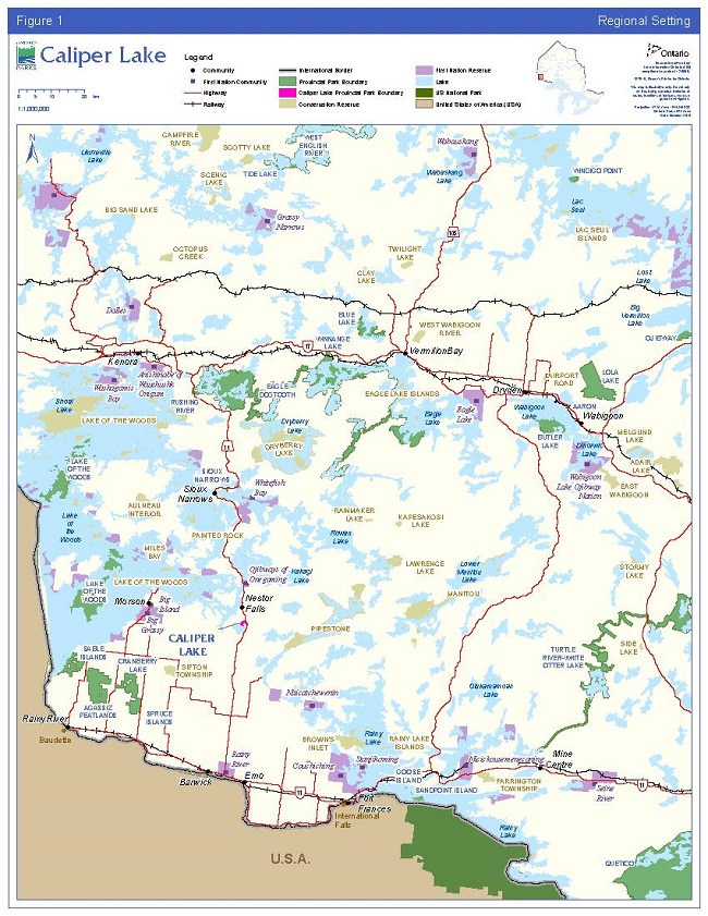
Enlarge Figure 1 - Provincial/Regional context map
3.0 Park classification
Caliper Lake is a recreational class park. As described in the PPCRA, recreational class parks provide a wide variety of compatible outdoor recreation opportunities in attractive natural surroundings.
The majority of the developed area in the park, including the campground area, is situated on the shores of Caliper Lake. The park provides opportunities for a wide variety of recreational activities.
4.0 Purpose
Caliper Lake Provincial Park was originally established as a wayside rest area along Highway 71. Today it contributes to the protection of critical landform-vegetation units and contains a mature stand of red and white pines somewhat unique in size, age, and uniformity, occurring in the transition between the Great Lakes – St. Lawrence forest and the boreal forest.
The overall purpose of the park is to protect the natural features of Caliper Lake Provincial Park, while providing heritage appreciation, education and a variety of ecologically sustainable opportunities for recreation.
5.0 Vision
The long-term vision for Caliper Lake Provincial Park is to continue to provide quality recreational opportunities to the public, while ensuring natural characteristics of the park’s ecology are maintained.
The park has a long history of providing recreational opportunities, and shall continue to do so through its operating partnership. While providing these opportunities, the ecological integrity of the park must also be addressed, considered, and given priority where possible.
6.0 Objectives
As stated in the PPCRA, Ontario’s provincial parks system has four objectives for establishing and managing provincial parks:
Permanently protect representative ecosystems, biodiversity and provincially significant elements of Ontario’s natural and cultural heritage and to manage these areas to ensure that ecological integrity is maintained;
- Provide opportunities for ecologically sustainable outdoor recreation opportunities and encourage associated economic benefits;
- Provide opportunities for residents of Ontario and visitors to increase their knowledge and appreciation of Ontario’s natural and cultural heritage; and
- Facilitate scientific research and to provide points of reference to support monitoring of ecological change on the broader landscape.
6.1 Protection objective
Ontario’s protected areas play an important role in representing and conserving the diversity of Ontario’s natural features and ecosystems across the broader landscape. Protected areas include representative examples of life and earth science features, and cultural heritage resources within ecologically or geologically defined regions. Ontario’s ecological land classification system provides the basis for the life science feature assessment, and the geological themes provide the basis for earth science assessment.
The park’s protection objectives are:
To permanently protect the ecosystems of Caliper Lake Provincial Park, including glacial features which support vegetation, by allowing them to function as freely as possible considering the size and setting of the park.
To ensure that conditions persist which can effectively support continued ecologically sustainable recreation, use and interpretation of features at Caliper Lake.
To manage, operate and develop the park to ensure that ecological integrity is considered and maintained, and restored (where appropriate).
6.1.1 Life sciences
Located within Ecoregion 4S (Lake Wabigoon) and Ecodistrict 4S-6 (Kenora), Caliper Lake Provincial Park is situated on terrain typical of the Precambrian Shield in northwestern Ontario. In addition, limy clay deposits originating from glacial Lake Agassiz can be found in depressions on the landscape. This ecodistrict contains the middle Winnipeg River watershed, excluding the lower Rainy River watershed (Crins et al. 2005).
Vegetation is best described as representative of the north-south transitional zone between the Great Lakes-St. Lawrence and the boreal forests (Noble 1977).
6.1.1.1 Representation analysis
A complete representation analysis (Crins and Kor 2000) using landform-vegetation (L/V) information was conducted for Caliper Lake Provincial Park. Despite the park’s small size, Caliper Lake Provincial Park makes a significant contribution to the minimum representation guidelines for the Kenora Ecodistrict. The park contains nine different L/V associations, four of which are critical in meeting the representation targets for the Kenora Ecodistrict. Critical L/V associations include: open marsh/fen/bog, thicket swamp, aspen dominated, and jack pine mixedwoods all on fine lacustrine and glaciolacustrine soil. Caliper Lake Provincial Park contributes the only representation of jack pine mixedwoods and a high component of thicket swamp on fine lacustrine and glaciolacustrine soils in protected areas in the Kenora Ecodistrict.
6.1.1.2 Vegetation communities
Caliper Lake Provincial Park is located within a transition zone where Great Lakes-St. Lawrence forest and boreal forest both exist (Rowe 1972). In general, six major forest communities represent the vegetation cover in Caliper Lake Provincial Park. They can be generally described as: red pine - white pine uplands, pure jack pine, jack pine mixed woods, ash-alder-willow wetlands, marsh wetlands, and aspen dominated mixed woods (Goddard 1983; OMNR 2005).
Although mature red and white pine stands are representative of the region, the stands in Caliper Lake are unique due to their large size, age and uniformity (Goddard 1983). Upper canopy trees within the stands reach heights of 30 – 40 metres with an average diameter at breast height measurement of fifty centimetres (Goddard 1983). Forest Resource Inventory (FRI) data indicates the pine stand originated around 1840. Much of this community is included in the development zone; however a substantial proportion has been included in the nature reserve zones, where it will receive the maximum level of protection. Over the years, the white pine trees have been affected by minor infestations of white pine blister rust and lightning strikes. With aggressive fire suppression action, the fire cycle has increased dramatically in recent years, which has resulted in a shift in forest age class and species composition (e.g., higher presence of fire sensitive, shade-tolerant species such as balsam fir, and reduced red and white pine regeneration).
Figure 2 - Vegetation Communities and Critical L/V Associations
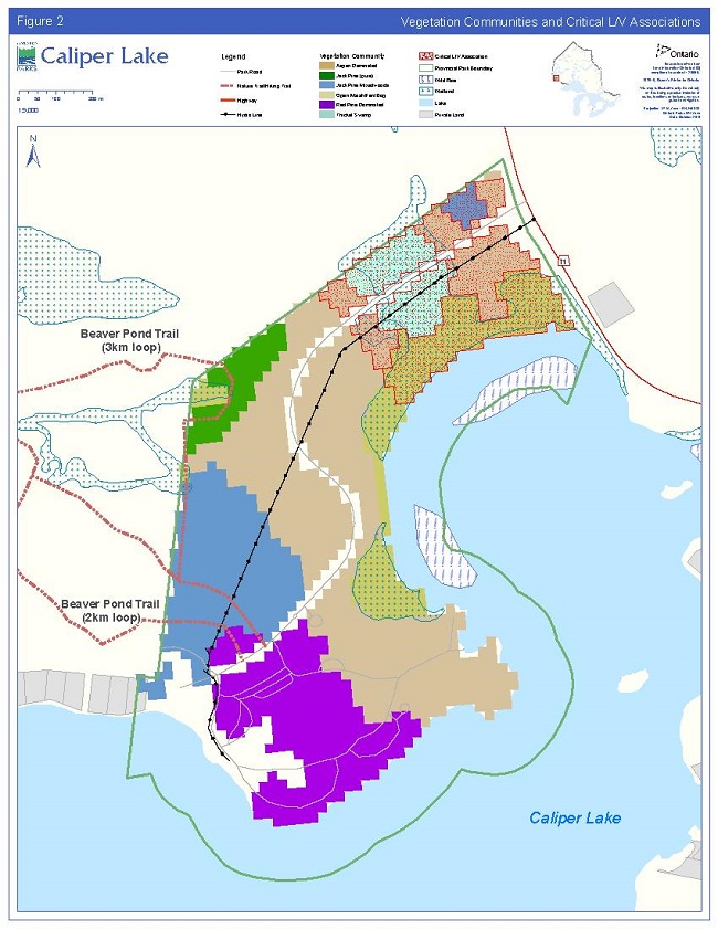
Enlarge Figure 2 - Vegetation Communities and Critical L/V Associations
6.1.1.3 Fauna
Although a detailed inventory has not been completed for Caliper Lake Provincial Park, the fauna is typical of the Great Lakes-St. Lawrence forest and also contains elements of the boreal forest. Species common to the park are white-tailed deer, wolf, lynx and various year-round and migratory birds (Goddard 1983). Bald eagle, a species designated as special concern and American white pelican, a species designated as threatened on the Species at Risk (SAR) in Ontario list are common in the area (OMNR 2013). Bald eagles and barred owls have been known to nest within the park boundaries (Goddard 1983) and white pelicans nest in large colonies on nearby Lake of the Woods (Harris and Foster 2004).
6.1.2 Earth sciences
Caliper Lake Provincial Park encompasses a moderately-broken terrain typical of the Precambrian Shield of northwestern Ontario and lies within the Wabigoon Subprovince of the Superior Province. Steeply sloping bedrock knolls and ridges outcrop along much of the shoreline and form basins in which swamps and bogs marked by thick clay deposits and organic build-up are common (Kor 1977). Several cliff faces of various heights not exceeding about five metres occur within the park.
Surficial deposits, remnants of the last glacial event about 11,700 years ago, consist predominantly of a very thin to patchy mantle of glacial sediment, namely medium-grained, dark to medium-brown, silty, clayey sand till (Kor 1977). Boulders of local origin are common, and various sized stones are strewn throughout the park. One erratic boulder, consisting of a felsic volcanic rock, occupies a prominent position on the nature trail (Kor 2009).
6.1.3 Cultural heritage resources
Caliper Lake Provincial Park is situated in an area rich in cultural history.
The Lake of the Woods area provided productive hunting grounds, wild rice fields and numerous transportation routes, which were the basis of survival for the Cree and Assiniboine (and later the Ojibway) people (Beaudry and Lavender-Sexsmith 1983). Relatively little is known about the cultural affiliations and distribution of Indigenous people prior to European contact (Beaudry and Lavender-Sexsmith 1983). A testimony to the area’s rich Indigenous history is the existence of several First Nation communities located in the Lake of the Woods area (Figure 1).
The French began to explore the Rainy Lake-Lake of the Woods area during the 17th century in search of profitable furs, and both the French and English had established fur trade posts after 1700 (Beaudry and Lavender-Sexsmith 1983). The construction of Highway 71, linking Kenora and Fort Frances, was a public works effort during the Great Depression. Upon completion in 1936, tourism began to increase in the area. Sioux Narrows – Nestor Falls continues to be a popular vacation destination.
No known cultural heritage resources exist within the park boundaries, however there are two registered archaeological sites located in close proximity to the park (Lambert 1983). It is believed that "the lack of known historical values in the park may reflect its isolation from the mainstream of local fur trade routes" (Beaudry and Lavender-Sexmith 1983).
6.2 Recreation objective
The park’s recreation objective is:
To continue to provide high-quality day-use and overnight camping opportunities in a manner which considers and attempts to minimize the associated impacts of such activities on the park and surrounding ecosystem.
Caliper Lake Provincial Park provides numerous opportunities for a variety of compatible high quality recreational activities. The park includes facilities for car camping and day-use. The most popular activities include resting/relaxing, swimming/wading, canoeing, hiking, fishing, and viewing/photographing nature.
Although the park is officially closed in the winter, some activities do take place in the park by local residents such as cross country skiing (on un-groomed trails), snowshoeing and walking.
6.3 Natural and cultural heritage appreciation objective
The park’s heritage appreciation objective is:
To provide park visitors with opportunities to learn about the natural heritage features of Caliper Lake, such as glacial history, vegetation communities, including the pine forest, and the conditions and species these values support. Cultural heritage themes relevant to the park will be included, should resources be discovered.
Natural heritage education for Caliper Lake Provincial Park is conducted through self-use facilities, including; a self-guided nature trail and informal interpretive displays in the park office.
7.0 Boundaries
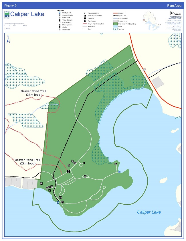
Caliper Lake Provincial Park is bordered by Crown land to the west, and by Caliper Lake to the east (Figure 3). The park boundary extends 152.4 metres (500 feet) into Caliper Lake to include that portion of the lake bed. There is one small private parcel of land adjacent to the southwest boundary of the park on the Caliper Lake shoreline. Highway 71 abuts the northeast boundary. Four parcels of land were acquired by the Crown between 1958 and 1977 and regulated as part of the park in 1991.
Within the regulated park boundary, the protection of park values and features will be achieved through appropriate zoning, the control of land use and activities, education, and monitoring of ecological impacts.
Additions to the park will be considered if the property is needed to enhance the values of the park (see section 8). Potential acquisitions are subject to available resources and the willingness of the owners to sell or lease their properties.
8.0 Adjacent land uses
Several parcels of private land are located on Caliper Lake, one of which is directly adjacent to the park. The park road is used to access private lands beyond the park boundary.
Caliper Lake Provincial Park is surrounded by an active trapline area (FF5), an active bear management area (BMA; FF-07B-097) and an active bait harvest area (FF0156). The regulated park is excluded from these areas. Crown lands adjacent to the park are within the Crossroute Forest Management Unit.
Most of the hiking trail network that begins and ends in the park is located on Crown land outside of the park (Section 9.4.4). For operational reasons and to protect and enhance the recreational interests that this trail provides, this area (approximately 33 hectares) may be added to the park through a future land use planning process, subject to consultation.
An Ontario Federation of Snowmobile Clubs trail exists on Caliper Lake outside of the park (Section 9.4.3).
Figure 3 - Plan Area
9.0 Park policies
The following policies apply to the whole park.
9.1 Industrial and commercial uses
The following industrial activities are prohibited in Caliper Lake Provincial Park:
- commercial timber harvest;
- prospecting, staking of mining claims, developing mineral interests, working mines;
- extracting aggregate, topsoil or peat;
- generation of electricity;
- other industrial uses.
The following commercial activities are prohibited in Caliper Lake Provincial Park:
- trapping
- bait harvesting
- bear management area(s) (BMA).
9.2 Adaptive management
An adaptive management approach will be applied to resource management activities within Caliper Lake Provincial Park. The main premise behind adaptive management is that ecosystems are complex and dynamic. Our understanding of ecosystems and our ability to predict how they will respond to our management actions and disturbances is often limited. These knowledge gaps lead to uncertainty over how best to manage parks to meet the obligation of maintaining ecological integrity.
Implementing an adaptive management approach allows researchers to design robust experiments, with careful consideration, to evaluate management options. This in turn provides park managers with directly relevant and scientifically defensible information to help them make management decisions (Kingston and Mosley 2007).
9.3 Resource management policies
Planning and management decisions are intended to ensure the maintenance of ecological integrity of protected areas. Consideration will also be given to social and economic components. Ontario Parks will ensure that these decisions are made with the best available information. Where this information is lacking, Ontario Parks may conduct research, inventories and monitoring, as necessary, to provide this information. Such efforts will be undertaken based on established methodologies and best practices and will foster an adaptive management approach.
The site specific policies that follow will guide the management of park resources consistent with the PPCRA, the Endangered Species Act, 2007 (ESA), and with the requirements of the Environmental Assessment Act, 1990 (EAA). Resource management projects and activities will be undertaken consistent with the Class EA-PPCR, where applicable.
This management plan does not intend to affect Aboriginal or treaty rights and associated traditional uses.
9.3.1 Land management
Management of the Caliper Lake Provincial Park land base will be directed towards maintaining the park’s natural landscape and protecting its ecological integrity.
A right-of-way for an electricity distribution line, under authority of a land use permit (LUP), extends through the park to provide power to the park and the adjacent cottages (Section 9.3.7). This use may continue and tenure may be renewed. Maintenance of the right-of-way and distribution line is permitted through notification and coordination with the park superintendent.
Comfort station waste generated from campground use will be disposed of using Ministry of the Environment and Climate Change-approved septic systems.
No private recreation camps, boat caches or commercial tourism operations exist within Caliper Lake Provincial Park. No new private, non-commercial dispositions or outright sale of park land are permitted.
9.3.2 Water management
The health and integrity of ecological communities, existing within aquatic areas, will be given priority when assessing feasibility and potential negative effects of any new developments or activities.
Drinking and bathing beach water sampling and testing will be carried out in compliance with:
- the Safe Drinking Water Act, 2002 and associated regulations; and the
- Ontario Beach Monitoring Protocol.
9.3.3 Alien and invasive species
Ontario’s Biodiversity Strategy defines alien species (also referred to as introduced, non-native or exotic species) as "plants, animals and micro-organisms that have been accidentally or deliberately introduced into areas beyond their normal range". Alien species will not be deliberately introduced into Caliper Lake Provincial Park (Ontario Biodiversity Council 2011).
There are several common alien species (e.g., white sweet clover, three-toothed cinquefoil, stinging nettle and oxeye daisy) established in the park, however none are known to currently threaten natural values. Section 9.3.12, identifies the monitoring efforts in place within the park.
Where possible, actions will be taken to eliminate or reduce the threat of invasive species which may be affecting naturally occurring populations. Where alien invasive species are already established and threaten natural values or cultural heritage resources, a control program may be undertaken if feasible and practical.
9.3.4 Insects and diseases
Native insects and disease are a natural and integral part of the ecology of Caliper Lake Provincial Park that will normally be allowed to fulfill their ecological role. In exceptional circumstances, control measures will be considered if values of the park are threatened. Insect and disease control measures for alien, and in some extreme cases native species, will be considered if the values, including the ecological integrity, of the park are threatened.
Forest insect and disease infestations may be monitored, assessed and treated in the campground for aesthetic and safety reasons. In extreme cases, treatment may take place to minimize effects of insects and disease on campground aesthetics.
White pine blister rust, an invasive disease, exists in both pine trees (primary host) and species of Ribes (currant), and can be transmitted between tree and shrub species. Removal of infected currant and/or gooseberry plants, by means of hand tending, may be considered if white pine blister rust persists and becomes problematic (Section 9.3.7). Pruning of white pine trees may also be considered to mitigate infestation.
Monitoring and research activities pertaining to insects and disease within the park are encouraged, based on available funding (see Section 9.3.11).
9.3.5 Forest fire management
Caliper Lake Provincial Park is located within the boreal forest where fire is a major disturbance. The relatively short fire cycles of the boreal forest create a forest mosaic mainly composed of pure or mixed, even-aged stands at different stages of recovery (Van Sleeuwen 2006).
Red pine, white pine and conifer mixed wood forests located within the park are typically fire-maintained community types. Prior to settlement and fire protection, mixed red-white-jack pine forests within the park likely experienced a variable fire regime of low intensity fires at short intervals punctuated by stand replacing fires at longer intervals (Van Sleeuwen 2006).
The Wildland Fire Management Strategy (OMNR 2014) provides strategic direction for the management of forest fires across Ontario. According to this provincial strategy all wildland fires are assessed and receive the most appropriate response aimed at limiting losses from fire damage, maximizing resource and ecological benefits and lowering costs.
9.3.5.1 Fire response
The park’s proximity to the Highway 71 corridor and the community of Sioux Narrows-Nestor Falls makes it impractical to allow forest fires to function freely, without putting values within and adjacent to the park, at risk. As a result, forest fires in the park will be suppressed and response options such as modified response or monitoring will not be used. "Light on the land" fire suppression techniques will be used whenever feasible. These minimal impact suppression techniques do not unduly disturb natural values or cultural heritage resources.
The response for structural fires and forest fires is guided by an informal agreement between the MNRF and the Township of Sioux Narrows – Nestor Falls. Fire evacuation procedures will be outlined in the Fire Emergency and Evacuation Plan for Caliper Lake Provincial Park.
Prescribed burning may be used to maintain naturally occurring vegetation communities in the park or to reduce fire hazards. Any prescribed burns will be planned and executed in accordance with the Prescribed Burning Operations Policy (OMNR 2015b), with the cooperation of the Aviation, Forest Fires and Emergency Services Branch’s (AFFES) Planning and Information Management Team and the Fort Frances Fire Management Headquarters.
9.3.5.2 Additional fire direction
Partial or total fire bans may be put in place and enforced at the discretion of the park superintendent following consultation with MNRF fire staff and the local municipal fire department.
Ontario FireSmart program principles will be considered where possible to protect park infrastructure. Steps will be taken to reduce or mitigate the threat posed by fire to infrastructure.
Fuel caches for purposes other than use by park staff during regular operation and maintenance activities are not permitted in the park.
9.3.6 Species at Risk (SAR)
Species found within the park are described in Section 6.1.1.3.
SAR and their habitats will be protected in a manner consistent with the ESA, 2007 and associated regulations.
9.3.7 Vegetation management
The park’s vegetation communities are described in Section 6.1.1.2.
Management of the park’s vegetation will be directed towards maintaining and protecting the ecological integrity of the park and to support the evolving natural succession of plant communities.
Subject to the Class EA-PPCR, vegetation management, landscape management or restoration projects may be developed to address impacts of recreation and park use so that ecological integrity is maintained or restored within the park. While maintaining the park’s ecological integrity remains a priority, restoration efforts shall be considered in highly compromised areas, including within the development zone. This may include trail rehabilitation, and the planting of vegetation in the development zone (e.g., campground) to ensure the succession of vegetation.
The removal of hazard trees will be permitted in all zones where safety is a concern (e.g., trails and campground). Underbrush may be cleared around park buildings using FireSmart (Section 9.3.5.2) techniques to mitigate potential fire damage and protect park infrastructure.
Areas experiencing adverse use impacts (e.g. root exposure, trampling, limb cutting and damage from vehicles) will be rehabilitated whenever possible. Should planting or seeding be necessary, species native to the park will be used. Seed sources of these species will originate from the park or a nearby location.
Although white pine blister rust is present, it is not considered to be a problem at this time. If the condition persists, pruning infected pine and removal of Ribes plants (the alternate host for the fungi) by means of hand tending should be examined (Section 9.3.4).
Herbicide applications, including in the hydro corridor, will be discouraged. Insect and disease control measures are found in Section 9.3.4.
Any development that requires the removal of vegetation other than hazard trees will be supported by a vegetation inventory in accordance with approved site plans.
9.3.8 Wildlife management
Management of wildlife in Caliper Lake Provincial Park will be directed towards maintaining and protecting the park’s ecological integrity. Proposed wildlife management projects and activities may be subject to the Class EA-PPCR.
The Cervid Ecological Framework (OMNR 2009) guides management of cervid species in the park and on the surrounding landscape. American elk and woodland caribou will be monitored and sightings documented, as the park is contained within the Cervid Ecological Zone 'C1' of this framework.
Displaced and nuisance animals (e.g., black bears) may be controlled when essential to human health and safety, the health of the species outside the park or the values for which the park has been established.
Where control is necessary, humane techniques having minimal effects on other components of the park’s environment will be used.
9.3.9 Fisheries management
Caliper Lake experiences heavy angling pressure from park users, cottagers and tourist camp patrons (OMNR 1987). Target species include: walleye, black crappie, smallmouth bass and northern pike.
Ontario has adopted a broad, landscape-level approach to fisheries management by creating Fisheries Management Zones (FMZs). These areas have "similar ecological, physical, social and economic attributes and are intended to delineate areas that are expected to react similarly to external changes, pressures and management actions" (OMNR 2012b). Lake of the Woods is included in FMZ 5. A fisheries management plan for FMZ 5 is in development.
Priorities identified by the Fisheries Management Zone Advisory Council for FMZ 5 and the MNRF include; managing for the quality of the walleye fishery, the sustainability of lake trout populations, establishing management objectives for northern pike given current regulations, as well as smallmouth bass and crappie (OMNR 2012b).
Ontario Parks encourages the inclusion of parks during broad scale monitoring programs of FMZ 5 as per Ontario’s Ecological Framework for Fisheries Management. Additional monitoring activities for Lake of the Woods, beyond what is carried out during the monitoring of FMZ 5, may be considered, based on need and available funding.
9.3.10 Cultural heritage resources management
Cultural heritage resources include archaeological resources, built heritage resources and cultural heritage landscapes.
There are no known cultural heritage resources in the park. If any are identified then those resources will be protected, maintained, used and disposed of in accordance with existing applicable legislation and policies.
If cultural heritage is discovered, MNRF will follow the contingency plan requirements as outlined in A Technical Guideline for Cultural Heritage Resources for Projects Planning Under the Class EA-PPCR.
Ontario Parks will consult with nearby Indigenous communities on matters pertaining to Indigenous history, identification of cultural heritage resources, interpretation of Indigenous history, and appropriate use of cultural artefacts. The precise location of any found Indigenous cultural sites, including burial sites, will not be disclosed to the public.
The removal of artefacts or destruction of historical features is illegal and is prohibited by the PPCRA (O. Reg. 347/07 s.2 (1)).
9.3.11 Research
MNRF encourages scientific research by qualified individuals contributing to the knowledge of natural and cultural history and to environmental management. Ontario Parks will review proposed research to ensure adequate consideration of potential impacts on protected area resources, features, staff and visitors.
Research and monitoring activities require a research authorization letter issued under the Research Authorization for Provincial Parks and Conservation Reserves Policy and must be consistent with Ontario Parks' research and information strategies (Ontario Parks 1997). Research will be subject to development and management policies associated with the park’s classification, unless special permission is given. Research must meet all requirements under applicable provincial and federal legislation, and may require additional permits or approval (e.g. MNRF Wildlife Scientific Collector authorization or ESA permits).
Sites altered by research activities or temporary research facilities must be rehabilitated as closely to their previous condition as possible, except where the specific intent of the research activities is disturbance for the purpose of ecological enhancement or restoration.
9.3.12 Inventory and monitoring
A number of management actions are proposed within the management plan to assist in identifying inventory and monitoring needs, including: public input, routine park maintenance activities, staff knowledge and experiences, and environmental scans. In addition, monitoring may be conducted to support the assessment, design and implementation of new and existing developments, projects and activities or as part of monitoring required under the Class EA-PPCR.
Three Ontario Parks Inventory and Monitoring plots (OPIAM) (McCaul and Kingston 2012) were established in 2005. These plots can be used to observe changes in vegetation communities and ecological integrity over time, as well as monitor breeding birds, other wildlife, and alien species. Additional monitoring plots will be encouraged.
9.4 Recreation management policies
Opportunities to enjoy high quality outdoor experiences available in Caliper Lake Provincial Park will be encouraged, provided they do not compromise the integrity of the park’s natural features. Those activities that are incompatible with the park vision or objectives will be prohibited or restricted.
9.4.1 Hunting
Sport hunting is not permitted in Caliper Lake Provincial Park.
9.4.2 Recreational fishing
Recreational (sport) fishing is permitted in the waters of Caliper Lake.
Recreational fishing is one of the most commonly practiced activities in the park. The park supports this activity by providing two boat launches, docking facilities, and two fish cleaning stations.
Recreational fishing is subject to provincial (FWCA) and federal (Fisheries Act) fisheries legislation and regulations as set out in the Ontario Recreational Fishing Regulations Summary (MNRF annual publication).
9.4.3 Mechanized travel
Motorized snow vehicles (e.g. snowmobiles) are not permitted in the park. Signs are erected at the day-use area and the northern boat launch prohibiting the use of motorized snow vehicles in the park.
Recreational all-terrain vehicle (ATV) use is not permitted in the park.
The park superintendent may authorize motorized use to carry out park management and maintenance activities where needed.
Consistent with federal boating regulations, motorized watercraft are not permitted in designated swimming areas. Docking facilities adjacent to the boat launch are available on a first-come first-served basis.
9.4.4 Trails
The park’s single hiking trail, known as the Beaver Pond Trail, is accessible from the main road past the park office. The trail consists of a 2 km loop and a 3 km loop. Both loops begin and end in the park’s mature red and white pine stand. Both loops wind their way through a Jack pine community and feature a viewing platform situated on a small but rich wetland area. The longer loop of the trail goes around the wetland area.
The majority of the trail (2.11 km), including the wetland area, is located outside the park boundary (Figure 3). The remainder of the trail is located within the park’s nature reserve zone (NR-2) (Figure 4). The trail has not been identified as a value in the current forest management plan; therefore no area of concern prescription exists for it. There are no current allocations for harvesting in this area. The value has now been recognized in the Land Information Ontario system (LIO) and will be identified as a value in future forest management planning.
The trail currently experiences low levels of use. Visitor use will continue to be monitored. Updated interpretive signage and/or trail guide may be considered to enhance this facility.
Trails may be added as demand and funding permit in all zones.
9.4.5 Other recreational uses
Bicycling is permitted on the main park roads only (Section 10.1.1, Figure 3). Bicycles are not permitted on hiking trails or in nature reserve zones.
Camping is permitted on designated sites in the campground only (D -1 zone; Section 10.1.1). No backcountry camping is permitted in the park.
Hiking, cross country skiing and snowshoeing are permitted on park trails/roads in all park zones. Mechanized grooming for the purposes of cross-country skiing does not currently occur.
Swimming, canoeing, kayaking, recreational fishing, sailing and sail boarding are only permitted in Caliper Lake.
Rock climbing is not permitted in the park.
Other recreational uses may be permitted based on park objectives, provincial policies and subject to the Class EA-PPCR, as applicable.
9.4.6 Services for visitors
Food and beverage services, recreation equipment rental and sales, and retail sales will be determined through business planning in conjunction with the Northwest Zone and park operations plans.
9.5 Operations policies
A park operations plan will be prepared to provide staff with the necessary direction required to operate the park on a day to day basis. In addition to addressing the operations policies, the plan will include such topics as budget, staffing, maintenance schedules, enforcement, and emergency services. The provisions of the plan will be consistent with the approved Ontario Provincial Parks Minimum Operating Standards, and will be reviewed annually and updated as required.
9.5.1 Natural Heritage Education (NHE)
The goal of the NHE program is to develop visitor awareness and appreciation of Ontario Parks' natural and cultural heritage to foster an appreciation of the parks' system.
At Caliper Lake Provincial Park there is no dedicated NHE staff. Information and interpretation in this park consists of signs or information kiosks, trail guides, self-guided trails or interpretive displays.
An NHE plan will be developed when or if required and as funds permit. The scope and intent of all activities will be carefully defined to ensure their compatibility with park features.
9.5.1.1 Information
Basic information regarding Caliper Lake Provincial Park, its resources, and facilities, as well as general information about camping and the outdoors is distributed through a variety of means including: the park office, the Ontario Parks guide, park tabloid, park maps and the Ontario Parks' website.
9.5.1.2 Park interpretation
The park has one self-guided interpretive trail that focuses on the mature red and white pine forest. An updated trail guide or interpretive trail and additional interpretive signage about the provincial parks system may be considered as funding permits.
9.5.1.2 Outdoor recreation programs
NHE staff from nearby Rushing River Provincial Park may conduct outdoor recreation programs at Caliper Lake Provincial Park as demand warrants and availability permits.
9.6 Marketing and communications policies
Caliper Lake Provincial Park will be promoted in accordance with the Ontario Parks Marketing Plan.
Any promotional material developed by partner organizations must be reviewed and approved by Ontario Parks prior to distribution.
9.7 Development policies
All development undertaken by Ontario Parks or by partners on its behalf will be subject to the Class EA-PPCR, and will be carried out in accordance with approved site and development plans that meet development standards for provincial parks.
The maintenance of ecological integrity is a guiding principle in park planning and management, and will be considered during any new development. Areas proposed for development will require prior assessment for significant cultural heritage resources and natural values, such as SAR, to ensure these sites are suitable for development, and any values are identified and protected at the site.
The construction of new facilities or roads will be directed by approved implementation and site plans and will only be permitted in the development zone. No new facilities will be permitted in the Caliper Lake Zone (NE-1; Section 10.3.1) (Figure 4).
9.7.1 Internal roads, parking areas, maintenance and administrative areas
Ontario Parks will continue to monitor the condition of park infrastructure (e.g. roads, buildings) as well as the performance and standards of the operations and maintenance facilities within the park. Maintenance and general improvements will occur to maintain visitor safety. Upgrading and/or replacement of facilities will occur as required or as funds permit.
The existing park office facility may require replacement in order to improve worker health and safety conditions, and to enhance customer service and park security. The present facility lacks public washrooms, adequate parking, and backup or turn around lanes. A new office facility may also include road re-alignment and a new parking area.
The main park road floods regularly where it intersects the lowland area in the north part of the park. The current road bed may need to be raised and culverts added to rectify the seasonal flooding. Improvements of this nature will be completed as funding permits.
All upgrades and replacements will take into account park values (e.g. red and white pine stands).
9.7.2 Campground, day-use areas and trails
Ontario Parks will continue to monitor the quality of the day-use area and its facilities.
The campground at Caliper Lake Provincial Park was originally designed to accommodate tents and small trailers. Many of the campsites are not large enough to accommodate the increasing number and size of recreational vehicles (RVs). There has also been damage to the trees (e.g., bark scraped off, broken branches) due to collisions with RVs. Some sites in the park also require levelling in order to better accommodate trailers and RVs.
A small number of campsites may be combined in order to better accommodate larger vehicles and a small number of non-electrical sites may be considered for upgrade to electrical. This may also involve road re-alignment. Ontario Parks will continue to assess the viability and sustainability of the current campground and its facilities to ensure sites are in accordance with provincial standards.
Alternative roofed accommodations (e.g., cabins, yurts) or new campsites may be considered on the peninsula south of the eastern boat launch in the development zone on the site of a former cottage (D-1) (Section 10.1.1), as use warrants and resources become available. Alternative roofed accommodations may also be considered on existing campsites within the development zone (Section 10.1.1).
The existing water treatment plant will be replaced once planning for it is complete and as funding permits (Section 9.3.2).
Boat launch and docking facilities may be upgraded as funding permits and/or replaced as required. The relocation or expansion of existing facilities may be considered based on funding, need, and demand taking into account ecological integrity and park values.
Development of additional trails (e.g., including within nature reserve zones) may be considered based on need and demand for recreational opportunities or interpretive features. Changes to the existing trails may be considered if they are found to degrade or inhibit ecological values or processes from continuing in a healthy state. New trails or changes to existing trails will be designed to avoid or minimize impacts to natural values and cultural heritage resources in the park.
10.0 Zoning and zone management policies
Lands within Caliper Lake Provincial Park are zoned in accordance with their natural and recreational values and their need for protection and/or differing management requirements (Figure 4). Zones differentiate between the sensitivity of natural values and cultural heritage resources, and the permissible degree of development, recreational uses, and management practices within the park.
The four zoning categories, development, access, nature reserve and natural environment, and associated permitted activities proposed for Caliper Lake Provincial Park are based on the Ontario Provincial Parks: Planning and Management Policies (OMNR 1992). Figure 4 shows the extent and boundaries of the proposed zoning designations for Caliper Lake Provincial Park.
Figure 4 - Park Zoning
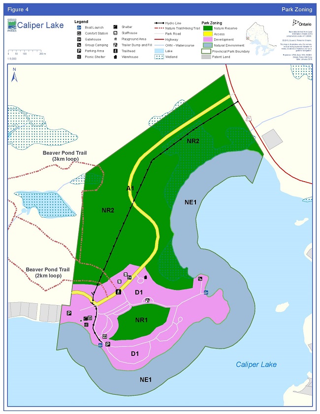
Enlarge Figure 4 - Park Zoning
10.1 Development zone
Development zones contain the area(s) of the park that are geared towards the support of intensive day-use and camping activities.
10.1.1 D-1 – Park road, campground & day-use area (29.5 ha)
The park’s development zone (D-1) is intended to include all areas of existing development including the campground roads, parking areas and administrative/maintenance facilities.
Facilities include: a campground containing 83 sites (27 of which are electrically outfitted), a day-use area with playground, picnic shelter and sheltered stage, two boat launches, docking facilities, two fish cleaning buildings, part of one hiking trail, one trailer dump and fill station, comfort station and septic field. Figure 3 shows existing development and facilities within the park.
The D-1 zone also includes the site that was previously occupied by a cottage. This site will remain undeveloped until a time where alternative roofed accommodations or additional campsites may be considered.
Park staff will monitor this zone for common symptoms of overuse such as exposed tree roots, soil compaction, and damage to trees.
10.2 Access zone
Access zones serve as staging areas, a means of both providing and regulating use in areas of a park geared towards extensive recreation. Generally development is limited to roads, visitor control structures and group campgrounds.
10.2.1 A -1 - Park road (4 ha)
This zone serves as the designated entry point to Caliper Lake Provincial Park from Highway 71, bisecting the park through the nature reserve and development zones. The zone begins at the park entrance and ends as it crosses the park boundary in the southwest side of the park. The road is 2.05 km long. The access zone is 20 m wide (10 m either side of centreline). The access zone does not include the campground roads (Figure 4).
This zone allows for the use of cars, trucks, and bicycles on the existing roadway.
10.3 Natural environment zone
Natural environment zones include natural landscapes which permit the minimum level of development required to support low-intensity recreational activities.
10.3.1 NE -1 – Caliper Lake (44 ha)
The purpose of this zone is to provide protection for the park’s shoreline features, including part of a wild rice stand, while providing opportunities for low-impact recreational activities on Caliper Lake.
This zone consists of the lands under water extending 152.4 m (500 feet), perpendicular to shore into Caliper Lake (Figure 4).
Development within this zone consists of two boat launch facilities and one docking facility.
10.4 Nature reserve zoning
Nature reserve zones protect the provincially significant earth and/or life science features within a park, and may include a protective area in which a minimum of development is permitted.
10.4.1 NR - 1 – Mature Red and White Pine (5 ha)
The park campground and day-use area are situated in the heart of a 150 year old red and white pine stand. The campground surrounds a large, undeveloped section of the stand. This area will be protected by nature reserve zone NR-1 (Figures 2 and 4).
10.4.2 NR - 2 – Mixed forest (65 ha)
The remainder of the park is zoned as nature reserve NR-2. The nature reserve zone includes portions of five significant vegetation communities including: red pine - white pine uplands, jack pine mixed woods, ash-alder-willow wetlands, marsh wetlands and aspen dominated mixed woods (Goddard 1983) (Figures 2 and 4). The communities located on fine lacustrine/glaciolacustrine soils make a significant contribution to the representation requirements of the Kenora Ecodistrict.
Existing development within the NR-2 is the park nature trail and an electricity right-of-way.
11.0 Implementation priorities
Park development, operations and resource management will be contingent upon the availability of funding and unforeseeable changes in priorities or policy. Implementation of the management plan and operation of the park will meet the requirements of the EAA, EBR, PPCRA, ESA and other pertinent legislation.
Park management, development and operations proposals will be phased in as funding is made available and/or as need requires:
- Annual review of the park operating plan;
- Ensure the hiking trail is identified as a value in forest management planning, and monitor its use;
- Replace park office and realign roads as necessary, while developing adequate associated parking facilities;
- Vegetation maintenance and/or restoration efforts in areas of the park highly disturbed to maintain/achieve ecological processes and goals;
- Minor development upgrades / replacement as needed to maintain day-use facilities including updates to trail signage and/or interpretive guides;
- Remove decommissioned shower building from day-use area;
- Mitigate vegetation damage in campgrounds and alleviate pressures to ensure damage is kept to a minimum, and other campground improvements as necessary; and,
- Preparation of a NHE plan.
12.0 Examination and adjustment of management direction
This plan will be examined after it has been in place for 20 years to determine whether it is still relevant, effective and current or if adjustments are needed. In circumstances where the plan is not providing sufficient direction, or to address specific issues or pressures, it can be examined prior to the next scheduled examination.
External requests for amendments to address specific proposals or needs may be considered. Ontario Parks can provide further guidance on the process for requesting an amendment and whether specific requests can/will be considered.
13.0 References
Beaudry, M and Lavender-Sexsmith, J. 1983. An historical research report and resource inventory of seven provincial parks in northwestern Ontario. Ministry of Natural Resources, Northwestern Region. 74pp. Unpublished Report.
Crins, W.J., Gray, P.A., and Uhlig, P.W.C. 2005. The Ecosystems of Ontario, Part 2: Ecodistricts. Ontario Ministry of Natural Resources. Unpublished Report.
Crins, W.J. and Kor, P.S.G. 2000. Natural Heritage Gap Analysis Methodologies Used by the Ontario Ministry of Natural Resources (Draft). Open File Natural Heritage Technical Report 2000-1
Goddard, A.W. 1983. Life Science Inventory of Caliper Lake Provincial Park.
Ontario Ministry of Natural Resources, Kenora. Unpublished Report.
Harris, A. and Foster, R. 2004. Life Science Inventory – Lake of the Woods Provincial Park. Northern Bioscience Ecological Consulting, Thunder Bay. Unpublished Report.
Kingston, S.R. and Mosley, E. 2007. Northwest Zone Research Strategy, Ontario Parks, Northwest Zone 2007. Ontario Parks, Thunder Bay. Unpublished Report.
Kor, P. 1977. Earth Science Inventory Checklist for Caliper Lake Provincial Park. Ontario Ministry of Natural Resources. Unpublished Report.
Kor, P. 2009. Personal communication. February 19, 2009.
Lambert, P.J.B. 1983. The 1983 archaeological survey of seven Ontario Provincial Parks in the Kenora Region and assessment of archaeological resources in adjacent geographic areas. Ministry of Natural Resources. Park Planning Branch. 106 pp. Unpublished Report.
McCaul, E., and S. Kingston, 2012. Ontario Parks Inventory and Monitoring Program: Guidelines and Methodologies (Version 1.4), May, 2012. Ontario Ministry of Natural Resources, Ontario Parks, Ontario.
Noble, T. 1977. Life Science Inventory for Caliper Lake, Red and White Pine Stand. Ontario Ministry of Natural Resources. Unpublished Report.
Nyberg, J.B. 1998. Statistics and the practice of adaptive management. Pages 1-7 in V. Sit and B. Taylor, editors. Statistical methods for adaptive management studies. British Columbia Ministry of Forests, Research Branch, Victoria, British Columbia, Land Management Handbook 42. [Online] URL: http://www.for.gov.bc.ca/hfd/pubs/docs/Lmh/Lmh42.pdf
Ontario Biodiversity Council. 2011. Ontario Biodiversity Strategy 2011: Renewing Our Commitment to Protecting what Sustains Us. Ontario Biodiversity Council, Peterborough, Ontario. 69pp. [Online] URL: http://viewer.zmags.com/publication/c527c66f#/c527c66f/1
[OMNR] Ontario Ministry of Natural Resources. 1987. Fort Frances District Fisheries Management Plan. Queen’s Printer for Ontario.
[OMNR] Ontario Ministry of Natural Resources. 1992. Ontario Provincial Parks: Planning and Management Policies (1992 Update). Queen’s Printer for Ontario, Toronto. 90pp.
[OMNR] Ontario Ministry of Natural Resources. 1999. July 1999. Ontario’s Living Legacy: Land Use Strategy. Queen’s Printer for Ontario. 136pp.
[OMNR] Ontario Ministry of Natural Resources. 2005. A Class Environmental Assessment for Provincial Parks and Conservation Reserves. Queen’s Printer for Ontario, 120 pp.
[OMNR] Ontario Ministry of Natural Resources. 2006. A Technical Guideline for Cultural Heritage Resources for Projects Planned Under the Class Environmental Assessment for MNR Resource Stewardship and Facility Development Projects and the Class Environmental Assessment for Provincial Parks and Conservation Reserves. Unpublished Guideline.
[OMNR] Ontario Ministry of Natural Resources. 2009. Cervid Ecological Framework (Draft). [Online] URL: http://www.mnr.gov.on.ca/stdprodconsume/groups/lr/@mnr/@fw/documents/document/263997.pdf
[OMNR] Ontario Ministry of Natural Resources. 2011. Our Sustainable Future: A Renewed Call to Action; Ministry of Natural Resources Strategic Directions. (Unpublished document)
[OMNR] Ontario Ministry of Natural Resources. 2012. Background Information for the Development of a Fisheries Management Plan in Fisheries Management Zone 5. January 2012.
[OMNR] Ontario Ministry of Natural Resources. 2012. Species at Risk in Ontario (SARO) list. (online). Queen’s Printer for Ontario. Accessed: 30 January 2013.
[OMNRF] Ontario Ministry of Natural Resources and Forestry. 2014. Wildland Fire Management Strategy. Queen’s Printer for Ontario. URL: /document/wildland-fire-management-strategy.
[OMNR] Ontario Ministry of Natural Resources. (Published Annually). Recreational Fishing Regulations Summary. Queen’s Printer for Ontario.
[OMNR] Ontario Ministry of Natural Resources. 2015a. Ontario’s Protected Areas Planning Manual: 2014 Edition. Peterborough. Queen’s Printer for Ontario. [Online] URL: /document/ontarios-protected-areas-planning-manual
[OMNR] Ontario Ministry of Natural Resources. 2015b. Prescribed Burning Operations Policy: AFFES:FM:2:10.
Ontario Parks. 1997. Research Strategy and Information Strategy: Setting Priorities. Ministry of Natural Resources, Ontario Parks, Planning and Research Section. Unpublished Report.
Ontario Parks. 2001. Park User Survey: Camper Statistical Summary – 2000. Ministry of Natural Resources. Queen’s Printer for Ontario.
Ontario Parks. 2007. Four Year Camping and Day-use Permit Survey – 2006. Ministry of Natural Resources. Unpublished Report.
Rowe, J.S. 1972. Forest Regions of Canada. Canadian Forestry Service, Publication Number 1300.
Van Sleeuwen, M. 2006. Natural Fire Regimes in Ontario. Ontario Ministry of Natural Resources. Queen’s Printer for Ontario, Toronto.
14.0 Species list
Species by common name as mentioned within the document text. Please note: This list is not an exhaustive species list for the park.
14.1 Plant
14.1.1 Tree
Ash (Fraxinus spp.)
Jack pine (Pinus banksiana)
Large-toothed aspen (Populus grandidentata)
Red pine (Pinus resinosa)
White pine (Pinus strobus)
14.1.2 Shrub & forb
Alder spp. (Alnus spp.)
Currant & Gooseberry (Ribes spp.)
Oxeye daisy (Chrysanthemum leucanthemum)
Stinging nettle (urtica dioica)
Three-toothed cinquefoil (Sibbaldiopsis tridentate)
White sweet clover (Melilotus albus)
14.2 Animal
14.2.1 Bird
American White pelicans (Pelecanus erythrorhynchos)
Bald eagle (Haliaeetus leucocephalus)
14.2.2 Fish
Black crappie (Pomoxis nigromaculatus)
Northern pike (Esox lucius)
Smallmouth bass (Micropterus dolomieui)
Walleye (Sander vitreus vitreus)
Yellow perch (Perca flavescens)
14.2.3 Mammal
Caribou (Rangifer tarandus)
Deer (Odocoileus virginianus)
Elk (Cervus canadensis)
Moose (Alces alces)
14.2.4 Insect
Forest tent caterpillars (Malacosoma disstria)
Jack pine budworm (Choristoneura pinus)
14.3 Bacteria
Bt (Bacillus thuringiensis)
14.4 Fungi
White Pine Blister Rust (Cronartium ribicola)