Centennial Lake Provincial Park Management Statement
This document provides policy direction for the protection, development and management of Centennial Lake Provincial Park and its resources.
Interim Management Statement
Zone Manager’s Approval Statement
Centennial Lake Provincial Nature Reserve protects provincially significant life and earth science features.
This Interim Management Statement will provide direction for the custodial management of the nature reserve until such time as a park management planning process is completed.
I am pleased to approve this Interim Management Statement for Centennial Lake Provincial Nature Reserve.
Original signed:
John M. Immerseel
South Eastern Zone Manager
Ontario Parks
Kingston, ON
Date of Approval:
17-October-2002
1.0 Background
Centennial Lake Provincial Nature Reserve is located 75 km south of Pembroke and 88 km east of Bancroft in Renfrew County. The site was regulated as a nature reserve class provincial park under the Provincial Parks Act in 1989 (Ontario Regulation 256/89, Schedule 218). The existing park is part of what was the larger Centennial Lake Park Reserve.
Situated in the Madawaska Highlands, the nature reserve is dominated by several lakes and creeks, steep hills, ridges of bare rock and stands of mixed forest. The nature reserve consists of 5 parts, with one large inland area being disjunct from a moderate sized island and three small islets or part islets within the Madawaska River (Black Donald Lake). The Pembroke District Land Use Guidelines (MNR 1983) identified the earth and life science resources of the nature reserve as provincially significant.
Nature reserves are areas selected to represent the distinctive natural habitats and landforms of the province, and are protected for educational purposes and as gene pools for research to benefit present and future generations and for their intrinsic value to society.
The purpose of this Interim Management Statement (IMS) is to identify values of the nature reserve, provide guidelines to protect those values and describe any restrictions on use. This IMS is intended to guide the custodial management of the site until such time as a park management planning process is completed. The IMS guidelines place a priority on the protection of the heritage values of the nature reserve.
1.1 Planning Issues
The nature reserve is within the planning area of the Ontario’s Living Legacy Land Use Strategy (OLL LUS) approved in 1999. The management guidelines in this IMS are in accordance with Ontario Provincial Parks: Planning and Management Policies (1992) as amended by the OLL LUS (1999).
The Madawaska Highlands Land Use Plan (MNR 1996) was prepared to guide land use of the Crown land in the Madawaska Highlands area, which includes the nature reserve. The land use plan included management strategies specific to the nature reserve, related to enforcing sport hunting and trapping restrictions, and boundary marking. A standing advisory committee, established February of 1999, assists in implementing and monitoring the Madawaska Highlands Land Use Plan (MHLUP). Responsibility for implementing this land use plan is through Bancroft, Kemptville and Pembroke District MNR offices in cooperation with the advisory committee. The MHLUP is deemed part of the OLL LUS.
The nature reserve is within the MNR Ottawa Valley Forest Management Unit, for which a Forest Management Plan (FMP) was completed in 2001. This Forest Management Plan guides forest management activities on Crown lands adjacent to the nature reserve. The FMP identifies an area of concern for provincial parks, for which width and treatment varies depending on park classification. The area of concern for nature reserves consists of a 30 m minimum reserve within which there is no cutting, within a 120 m modified management area adjacent to the park boundary where no new roads or landings are permitted unless authorized by Ontario Parks staff (MNR 2001). Harvest allocations are identified adjacent to the boundary of the nature reserve.
Matawatchan Provincial Nature Reserve is situated approximately 10 km to the south west of Centennial Lake, and is within the same Ecodistrict (Ecodistrict 5E-11). Like Centennial Lake, Matawatchan is within the area of the MHLUP and Ottawa Valley FMP. Both nature reserves are administered by the South Eastern Zone of Ontario Parks. Because of their class and similar management issues, many guidelines in this IMS are common to the IMS guidelines for Matawatchan. Future management planning should consider the relationship between these two nature reserves and the surrounding Crown lands of the Madawaska Highlands area as part of a broader ecosystem approach.
2.0 Site Description
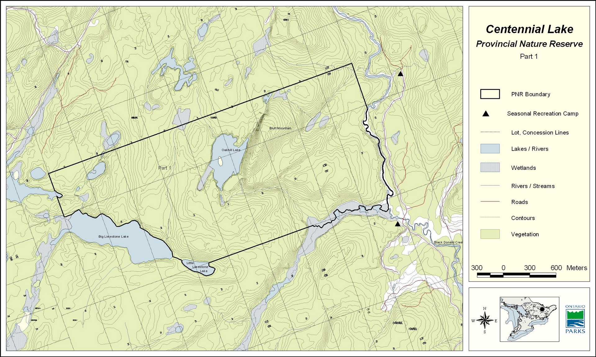
The property is situated in Ecodistrict 5E-11 (Bancroft Ecodistrict) of Ecozone 5E (Georgian Bay Ecozone), in an area dominated by low rolling hills and interspersed with numerous wetlands. Although the nature reserve is primarily forested, wetlands, marble rock barrens and low cliffs occur in a number of areas (White 1991). The nature reserve consists of three physically separate areas: a large inland area, a moderately sized island known as Black Donald Island, and a group of three small islets. The inland area wholly contains Oakhill Lake, a popular lake for fishing in the area, and the smaller Little Limestone Lake. Adjacent to Oakhill Lake is Bluff Mountain, the highest elevation within the nature reserve. The southwest boundary of the inland area (hereafter called the Oakhill Lake area) follows the shoreline of Big Limestone Lake and Little Limestone Lake. The eastern boundary of the Oakhill Lake area parallels Black Donald Creek. Black Donald Island and the 3 islets are located approximately 4.5 km south of the Oakhill Lake area, within the Madawaska River (Black Donald Lake).
3.0 Location
The 530 ha nature reserve is located in the Township of Greater Madawaska (formerly the Township of Brougham) in the County of Renfrew (Figure 1).
The property is comprised of five parts, as described above and indicated on the plan entitled "Algonquin-Centennial Lake" (File 194567, January 1986) (Figure 2, 3):
Part 1 – 470.0 ha - the Oakhill Lake area
Part 2 – 54.0 ha (island in Black Donald Lake)
Part 3 – 3.0 ha (part island in Black Donald Lake) – described above as an islet
Part 4 – 2.50 ha (part island in Black Donald Lake) – described above as an islet
Part 5 – 0.5 ha (part island in Black Donald Lake) – described above as an islet
The MHLUP (MNR 1996) indicated that boundary delineation of Matawatchan and Centennial Lake Nature Reserves and posting of these areas as no trapping and hunting was a first priority in the plan’s implementation process. Boundary delineation has not occurred to date; there is a need for boundary marking on the ground to enable enforcement of park policies and permitted activities.
Management guideline(s):
- The regulation plan should be updated prior to the park management planning process. Based on current policy, the official name of the nature reserve would be changed to "Centennial Lake Provincial Park (Nature Reserve Class)"
- To allow for enforcement of protective provisions, clearly delineating the park boundary on the ground will be a high priority. Signs will be posted at points of access to identify permitted uses
4.0 First Nations
The nature reserve falls within the Algonquins of Pikwakanagan land claim that is being negotiated by Ontario, Canada and the Algonquins concurrent with preparation of this IMS.
Management guideline(s):
- The management of this park will not abrogate or derogate from any Aboriginal or Treaty rights, as recognized and affirmed by section 35 of the Constitution Act, 1982
- Ontario Parks intends to communicate and work with appropriate Aboriginal communities throughout the planning and management of the park
5.0 Land Tenure and Land Acquisition/Disposition
The nature reserve is comprised of unpatented Crown land, in 5 parts. Part 1, or the Oakhill Lake area, is a large inland block that is surrounded by Crown land (Figure 2). The remainder of the nature reserve, Parts 2, 3, 4, and 5 (Figure 3) are islands or part islands on Black Donald Lake. Part 3, 4 and 5 have adjacent private lands. Ontario Parks, South Eastern Zone administers the nature reserve, and its management is the responsibility of the Bon Echo Provincial Park Superintendent.
Management guideline(s):
- No land acquisition is planned. Ontario Parks would not consider acquiring private land unless property that would enhance the values of the nature reserve is offered for sale by willing vendors
- No dispositions will be considered within the nature reserve
6.0 Provincially Significant Areas and Land Use Designations
The Pembroke DLUG (MNR 1983) identified provincially significant life and earth science resources within the nature reserve. The open marble barrens are an important feature, and among the most sensitive areas of the nature reserve (White 1991). Life science and earth science features are described in Section 8.0, Resource Information.
A Draft Official Plan has been prepared for Renfrew County, which includes the Township of Brougham (County of Renfrew Draft October 22, 2001). The Draft Official Plan identified the nature reserve as "Crown land" (other than an error in mapping that indicates Lot 35, Con 8, Brougham as "Rural"). The lands surrounding the Oakhill Lake area of the nature reserve are Crown land, and are designated as such in the Draft Official Plan.
The MHLUP (MNR 1996) addresses the management of natural resources with several objectives, the most pertinent to the nature reserve being the first objective: natural heritage protection including protecting representative natural areas, protecting vulnerable, threatened and endangered species, and implementing provincial park objectives. A copy of the Madawaska Highlands Land Use Plan is on file in the Ontario Parks, South Eastern Zone office.
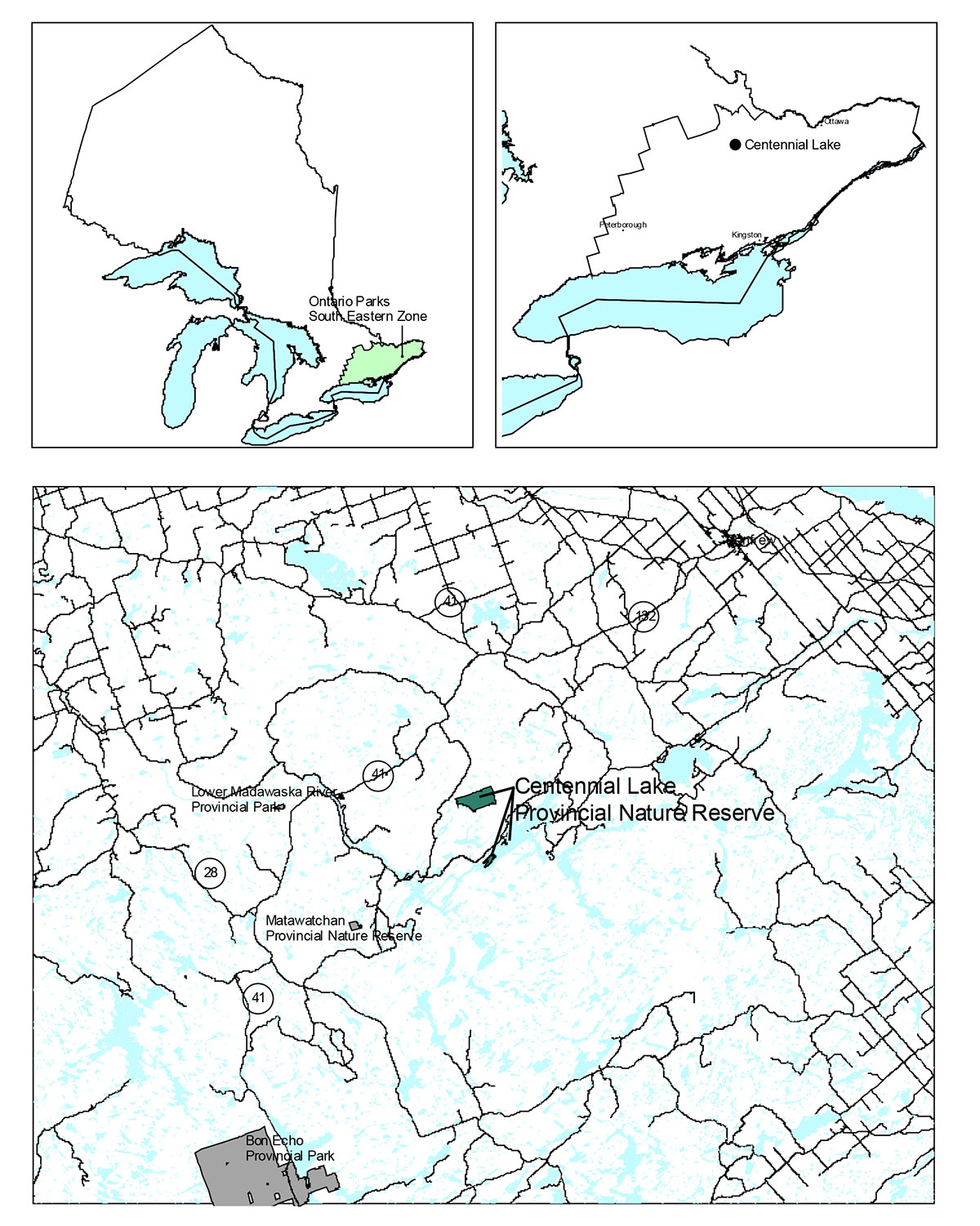
Figure 1. Regional Setting
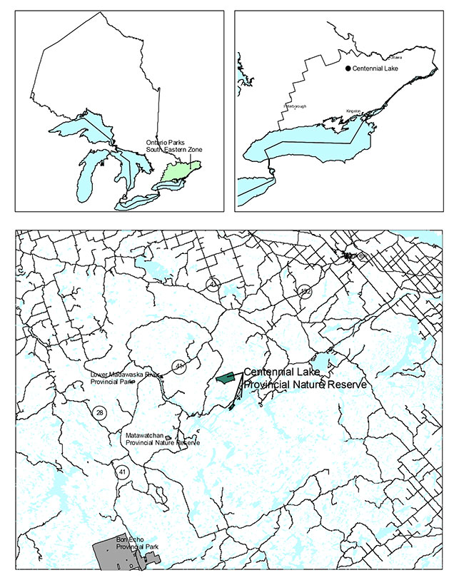
Enlarge Figure 1. Regional Setting
Management guideline(s):
- The property will remain classified and managed as a Provincial Nature Reserve. Decisions on zoning are not made until a park management planning process is completed
- Ontario Parks will recommend to the Ministry of Municipal Affairs and Housing that the County of Renfrew be asked to ensure that its official plan appropriately identifies the nature reserve’s land and waters, so that new development near the nature reserve is assessed with regard to any potential impacts on the nature reserve’s natural heritage values in accordance with provincial policy for other areas of provincial interest
- Ontario Parks will work with MNR, Pembroke District staff and the Madawaska Highlands Land Use Plan Standing Advisory Committee in implementing and monitoring projects associated with the nature reserve as identified within the Madawaska Highlands Land Use Plan
7.0 Access, Existing and New Development
Access to the nature reserve is poor, with primary access to the general area via County Road 71 (Matawatchan Road) to Black Donald Lake or County Road 65 (Centennial Lake Road). Access to the Oakhill Lake area (Part 1) of the nature reserve is via a gravel road that parallels Black Donald Creek (Figure 2). There is concern that secondary and tertiary roads constructed for the purposes of forest harvesting will increase the ease of access to this nature reserve.
The nature reserve contains no existing facilities.
Management guideline(s):
- If necessary park staff will take steps to prevent unauthorized access to the nature reserve from existing logging/access road locations (i.e. signage, enforcement). New access roads will not be encouraged within the 120 m road approval required zone identified in the Ottawa Valley FMP
- No development of facilities is proposed within the nature reserve
8.0 Resource Information
The island and islet parts of the nature reserve were created when flooding of the Madawaska River separated them from what is now the mainland (White 1991). The Madawaska River flows in an easterly direction into the Ottawa River at Arnprior. The nature reserve has been identified as a provincially significant Area of Natural and Scientific Interest (ANSI) due to its provincially significant bedrock formation, flora and vegetation (Brunton 1990). While there has been some inventory of the earth and life science features of the nature reserve, there has been no assessment of cultural resource values. A brief description of the earth and life science features of the nature reserve follows. More detailed information can be found within the assessment by White (1991), on file at the South Eastern Zone office.
Figure 2. Park Boundary (Part 1)
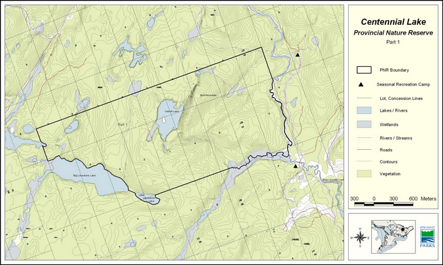
Enlarge Figure 2. Park Boundary (Part 1)
Figure 3. Park Boundary (Parts 2, 3, 4, 5)
Enlarge Figure 3. Park Boundary (Parts 2, 3, 4, 5)
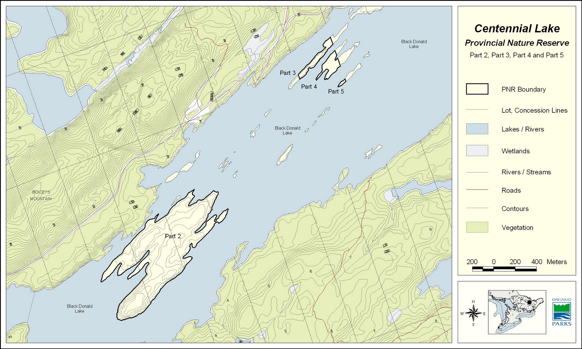
8.1 Earth Science Features
The nature reserve is located in the Grenville Province of the Canadian Shield. The northern areas of Black Donald Island are formed of intrusive igneous rock, while the southern portion is marble. The three islets are entirely intrusive igneous rock. The Oak Hills area is formed of granite and marble bedrock. It includes a large granite knob known as Bluff Mountain, and several areas of rock barren (White 1991). The Pembroke DLUG identifies the earth science resources of the nature reserve as being provincially significant.
Management guideline(s):
- A comprehensive earth science inventory of the nature reserve, including its geological processes and topographic and stratigraphic attributes, is recommended before a final management plan is prepared
8.2 Life Science Features
The nature reserve is situated in Ecodistrict 5E-11. The area is part of the Middle Ottawa Section of the Great Lakes-St. Lawrence Forest Region, consisting of both conifer and hardwood trees. The island areas of the nature reserve are primarily mixed forest dominated by Red pine and White pine. Provincially significant plant species occur in the marble rock barrens, low cliffs and shallow aquatic marsh areas of Black Donald Island (White 1991). The Oakhill Lake area is characterized by relatively undisturbed upland mixed forest dominated by Red oak. This area also contains marl flats and marl shoreline along Oak Hill Lake and rock barrens in several locations (White 1991).
White (1991) identifies that the provincially significant species in marble cliffs and rock barrens of Black Donald Island are close to current water levels, and so would be susceptible to any substantial increase in water level that could occur.
Oakhill Lake is a relatively small oligotrophic lake that is popular for sport fishing. It was stocked with Rainbow trout from the 1970s to 1991; the stocking was ceased following regulation of the area as a nature reserve. Updated fisheries information would assist in determining the health of the fishery resource.
The life science resources of the nature reserve have been identified as being provincially significant (MNR 1983; Brunton 1990, White 1991). The nationally rare (N1) Wood Spurge (Euphorbia commutata), ranked as provincially significant (S1) by the Natural Heritage Information Centre (NHIC), is found within the nature reserve. A portion of the Oakhill Lake area of the nature reserve is within a larger deer yard area.
Management guideline(s):
- It is recommended that the life science inventory information for the nature reserve (White 1991), including an aquatic/fisheries component, be updated before a management plan is produced. Partners and researchers will be encouraged to assist with this work
8.3 Cultural Resources and Traditional Land Uses
There has been no cultural resource inventory or assessment conducted on the property. There is little documented evidence of aboriginal use of the property. Algonquin speaking First Nations inhabited the region before Europeans arrived and settled in the late 1700s and 1800s. The majority of land, including the nature reserve, was under timber lease in the 1800s. Large stands of Red and White pine were cleared to meet the British demand for squared timber and subsequently for sawlogs and pulpwood. Timber was cut and transported along the Madawaska-Ottawa River systems to Ottawa for processing. In the 1900s, a new resource extraction activity developed – mining. Most of the region around the nature reserve was mined for corundum.
Presently, forest harvesting and processing activities continue to be important to the economy of the Madawaska Highlands. Tourism based industries, such as fishing and hunting lodges, have been on the increase, taking advantage of the natural resources of the area.
The Pembroke DLUG identifies the nature reserve as being of regional historical significance.
Management guideline(s):
- Investigation for possible cultural and archaeological resources within the nature reserve will be encouraged in association with universities, community colleges, museums and interested organizations and qualified individuals
9.0 Resource Stewardship
Due to the limited amount of inventory information available for the nature reserve, there is insufficient information available to support detailed resource stewardship activities in the interim. The existing inventory information has identified some species at risk within the nature reserve. The nature reserve provides core wintering habitat for deer.
In respect to forest management, the adjacent land is classified as having high potential (Pembroke DLUG, 1983). The property is located in the Ottawa Valley Forest Management Unit (FMU), formerly the Pembroke FMU. The forest management plan now in effect is the 2001-2021 Ottawa Valley FMP. Renewal and tending operations within the first 5 years of the plan include some areas of Crown land adjacent to the Oakhill Lake area of the nature reserve (Part 1).
Mineral and fossil fuel development in the immediate area is rated to have high potential. The nature reserve and adjacent land is identified as a low fire risk zone. It is within the East Fire Region.
Management guideline(s):
- Ontario Provincial Parks Planning and Management Policies for resource management activities in nature reserves will apply
- Management will ensure the protection of any species which is declared to be of vulnerable/special concern, threatened or endangered as listed in Schedule A of Ontario Parks Policy 11.03.02 – Protection of Vulnerable, Threatened and Endangered Species in Parks. Protection of these species is enforced through regulations under the Fish & Wildlife Conservation Act, Provincial Parks Act and Endangered Species Act. Specific locations of sensitive species and/or species deemed to be at risk will be kept confidential
- Ontario Parks and MNR, Pembroke District will continue to manage and protect significant fish and wildlife habitat and enforce sport hunting restrictions
- Any fires within the nature reserve will be managed as per Ontario forest fire management strategies. Human caused fires will be suppressed due to the small size of the nature reserve and the close proximity of hunt camps to the property
- Fish will be managed in accordance with the Pembroke District Fisheries Management Plan
- Ontario Parks will participate in reviewing the Ottawa Valley FMP and in identifying any implications there may be for the nature reserve. Each year Ontario Parks will review the annual forest operations work schedule with the Pembroke District office to ensure that there will be no detrimental impacts on the natural values of the nature reserve
10.0 Recreational Features and Activities
There are no access roads or private roads within the nature reserve. Because of the limited access to the area there is relatively little recreational use. Some unauthorized trails have been created within the Oakhill Lake area, including one to Oakhill Lake. White (1991) noted that any hiking trails should avoid marble barrens and cliffs, as they are sensitive to disturbance. Trail development is only considered during management planning. Some day use activities such as hiking, snowshoeing and cross-country skiing may occur, with travel generally following the unauthorized, unmaintained trails. Current policy states that existing uses for non-motorized recreation travel (canoeing , kayaking, hiking, cross-country skiing, snowshoeing) may continue in the interim, unless park values are threatened. Sport fishing occurs on Oakhill Lake, and is permitted by park policy. There have been reports of camping occurring near Oakhill Lake and on the park islands; this activity is not compatible with a nature reserve class park, and if existing is a non-conforming use that should be phased out.
Although there has been some evidence of on-trail snowmobile and all terrain vehicle use within the nature reserve, there currently are no authorized trails. There are no areas designated by the park superintendent for this use, nor any Land Use Permits or other MNR authorizations for this use associated with the nature reserve. Existing rough mapping of authorized trails of the Ontario Federation of Snowmobile Club shows trails close to, but not within, the nature reserve. There is currently an incentive to have these trails recorded using GPS to determine more accurate locations. Long term management direction for on-trail all terrain vehicle or snowmobile use is determined through management planning, and any use would be restricted to access zones. Mechanized use to support recreation activities (sport fishing) is not compatible with a nature reserve. Some of the existing mechanized use is likely linked to activities that are not compatible with nature reserves and are to be phased out (camping, sport hunting).
Two private recreation camps are situated on the periphery of the Oakhill Lake area of the nature reserve, but there are none within the nature reserve. The property is located in Wildlife Management Unit (WMU) 58 and the area surrounding the nature reserve provides many big game and small game hunting opportunities annually. Sport hunting is not compatible with nature reserve class parks, in accordance with Provincial Park Policy and the OLL LUS. There is evidence that sport hunting occurs within the property (spent shells) and it is suspected that this is mainly during deer season. The MHLUP called for enforcement of sport hunting restrictions within the nature reserve, and park policy directs that this existing non-conforming use be phased out.
Management guideline(s):
- Ontario Provincial Parks Planning and Management Policies for recreation activities and facilities in nature reserves, as amended by the OLL LUS, will apply. Low-intensity day-use activities that enhance appreciation of the natural values of the site will be permitted
- Non-motorized recreational and heritage appreciation activities (i.e. hiking, canoeing, cross-country skiing, photography, snowshoeing and wildlife viewing) will be permitted to continue in the interim, unless park values are threatened. Sport fishing is a permitted activity, and will conform to MNR recreational fishing regulations. Mode of access for these activities will comply with mechanized and motorized vehicle use restrictions
- Long term direction for mechanized use, including on-trail all terrain vehicle and snowmobile use, will be determined during management planning, and any such use would be restricted to access zones. In the interim, unauthorized mechanized use (on-trail all terrain vehicle and snowmobile use) will be phased out (boundary delineation, signage, monitoring, enforcement)
- If now existing, the following recreational activities are not compatible with the management objectives of the nature reserve and will be phased out: off-trail all terrain vehicle (ATV) use, camping, horseback riding, motorized boating, mountain biking, off-trail snowmobiling, and sport hunting. Phase out of these activities will be achieved through boundary delineation, signage, monitoring, and enforcement
- Group educational day trips to the nature reserve will be permitted, provided that the Park Superintendent is given prior notice, the group size is no more than 15 persons, and the trip is led by a person knowledgeable of the sensitive nature of the area
11.0 Commercial Activities
Commercial activity within the nature reserve is restricted to one registered bait harvesting licence. Provincial Park Policy and OLL LUS direction for provincial nature reserves is that existing commercial bait harvesting will be phased-out when either the licence is surrendered, the current licensee dies, or by December 31, 2009, whatever comes first. In accordance with this policy direction, the existing commercial bait licence that applies to block #82 was amended in February 2002 to exclude waterbodies wholly contained within the park boundary (i.e. Oakhill Lake). Enforcement of this amendment is contingent upon boundary delineation. Status Indians exercising treaty rights are permitted to continue commercial fur harvesting in all parks, subject to applicable legislation and regulation. Timber harvesting occurred adjacent to the northeast and southeast boundaries of the park between 1996 and 2001 through the Pembroke FMP. Renewal and t ending operations are planned for these areas in 2001 – 200 6 through the Ottawa Valley FMP.
Management guideline(s):
- Commercial mineral exploration or extraction, aggregate extraction, commercial hydroelectric development, commercial timber harvest are prohibited. No new commercial bait harvesting and commercial fishing operations
- Commercial fur harvesting is not permitted, except for trapping by Status Indians exercising treaty rights
- Easements for utility corridors such as hydroelectric, telecommunications and natural gas and infrastructure will be prohibited in the nature reserve
- Liaison with local timber harvesters will be maintained in order to encourage sound ecosystem practices adjacent to the nature reserve and within the watershed
12.0 Marketing and Partnerships
As a means of encouraging compatible use, the nature reserve will be given a low profile in Ontario Parks communications.
In terms of forging partnerships with the research community, Ontario Parks will promote the educational role of the nature reserve. Provincial Park Policy dictates that nature reserves be areas selected to represent the distinctive natural habitats and landforms of the province which are protected for educational purposes and as gene pools for research to benefit present and future generations. Ontario Parks will also promote the protection and heritage appreciation objectives and the need to ensure control of access and limits on the use of the property.
Management guideline(s):
- The nature reserve may be listed in general parks publications but will not be indicated on detailed maps, including the MTO Official Road Map for Ontario. To ensure future mapping publications comply with this direction, Ontario Parks, South Eastern Zone will seek to have the nature reserve boundary tagged as sensitive in the park boundary Natural Resource Values Information System layer to restrict the availability of specific location information
- If partnerships can be arranged, natural heritage agencies, naturalist clubs or interested individuals could be instrumental in providing regular monitoring of the reserve
13.0 Client Services
Information on the nature reserve is on file at the Ontario Parks, South Eastern Zone office (Kingston) and with the Superintendent of Bon Echo Provincial Park.
Management guideline(s):
- For general inquiries, information can be provided by contacting the Superintendent at Bon Echo Provincial Park, the Ontario Parks, South Eastern Zone office, or by visiting the Ontario Parks internet website (www.OntarioParks.com - website no longer active). If more detailed information is requested, other literature may be circulated at the discretion of Ontario Parks staff
14.0 Research
All research within the nature reserve, including research by Ontario and federal government agencies, will require Ontario Parks approval and must meet all other applicable provincial and federal requirements. With the exception of reconnaissance earth and life science inventory work, little research has been undertaken on the property. Research in the nature reserve is encouraged by Ontario Parks, however, since the site has been identified as having provincially significant life and earth science values, impacts due to human activity could become a problem if not carefully controlled. Research priorities will include an inventory of the nature reserve’s earth and life science features and cultural resources.
Management guideline(s):
- In keeping with Ontario Parks policy, all research applications will be subject to approval by the Superintendent of Bon Echo Provincial Park or t h e South Eastern Zone Manager. Approval will be granted if the research project satisfies the guidelines set forth in the research policy for Ontario Parks and the Research and Information Strategy for the South Eastern Zone, and may be subject to certain conditions
- All research must be compatible with heritage values and recreational uses of the nature reserve and conform to the research policies and strategies for Ontario Parks and the South Eastern Zone
15.0 EA Act Requirements
As part of the Ministry of Natural Resources, Ontario Parks, is a public sector agency, and is subject to the Environmental Assessment Act. Management activities in the nature reserve will be carried out in accordance with Declaration Order MNR-59/2 and the Class EA for Provincial Parks and Conservation Reserves (approval pending).
16.0 Implementation
Administration of the nature reserve is led by Ontario Parks, with custodial management by the Superintendent of Bon Echo Provincial Park. Implementation of the protective provisions within this IMS will be contingent upon funding and staffing resources and park boundary delineation.
Management guideline(s):
- The Ontario Parks, South Eastern Zone Manager will investigate funding options to support interim management of the nature reserve
- Partnerships could be established to assist in monitoring of the protective provisions within this IMS (Section 12.0)
- Ontario Parks will determine methods for enforcement of the protection guidelines outlined within this IMS (i.e. boundary delineation)
17.0 References
Brunton, D.F. 1990. Life Science Areas of Natural and Scientific Interest in Site District 5-11. Parks and Recreational Areas Section, OMNR, Eastern Region, Kemptville.
County of Renfrew. 2001. Official Plan County of Renfrew. Dr aft October 22, 20 01. Planning Division, Pembroke, Ontario.
Easton, R.M. 1992. The Grenville Province and Proterozoic History of Southern Ontario. Geology of Ontario, Ontario Geological Survey, Special Volume 4. Part 2. pp. 714-904.
Noble, T. 1984. Biophysiographic Analysis of Site Region 5E in the Algonquin Region. OMNR.
Ontario Ministry of Natural Resources (OMNR). 1978. A Brief Life Science Overview of the Centenial Lake Park Reserve. Division of Parks, Algonquin Region.
OMNR. 1996. The Madawaska Highlands Land Use Plan. Pembroke District.
OMNR. 1994. Ontario Provincial Park Management Planning Manual. Provincial Parks and Natural Heritage Areas Policy Branch.
OMNR. 1992. Ontario Provincial Parks: Planning and Management Policies (1992 Update). Provincial Parks and Natural Areas Policy Branch.
OMNR. 1988. Pembroke District Fisheries Management Plan 1986-2000. OMNR, Pembroke District.
OMNR. 1983. Pembroke District Land Use Guidelines. Regional Lands Office.
White, D.J. 1991. An Assessment of Representative and Special Life Science Resource Features of Selected Sites in the Fortune-Schooner-Centennial Lakes Study Area. OMNR, Eastern Region, Kemptville and Algonquin Region, Huntsville.
18.0 Appendices
18.1 Appendix 1. Interim Policies for Commercial, Management and Recreation Activities
This table focuses on policies for activities that are applicable to this park and are addressed in the IMS. The section that contains complete discussion of interim management direction is indicated in parenthesis. Refer to Ontario Provincial Parks: Planning and Management Policies (1992) and the Crown Land Use Atlas Policy Report for a comprehensive list of policies that apply to nature reserve class parks.
Commercial Activities (Section 11.0)
| Activity | Permitted* | Clarification of interim direction |
|---|---|---|
| Aggregate Extraction | No | |
| Commercial bait fishing< | No | Park removed from licence for block # 82 in Feb/02. |
| Commercial fishing | No | No existing licences. |
| Commercial fur harvest | No | No existing licences. Permitted by Status Indians enjoying Treaty rights. |
| Commercial hydro development | No | |
| Commercial timber harvest | No | |
| Commercial tourism | No | |
| Mineral exploration/development | No |
Management Activities (Section 9.0)
| Activity | Permitted* | Clarification of interim direction |
|---|---|---|
| Fire suppression < | Natural suppression subject to further planning. Human caused fires will be suppressed. |
|
| Fish stocking | No |
Appreciation Activities (Section 10.0)
| Activity | Permitted* | Clarification of interim direction |
|---|---|---|
| Nature appreciation-self guided | Yes | Existing use may continue in the interim, unless park values are threatened. |
| Photography and painting | Yes | |
| Research | Yes | Subject to prior authorization |
| Wildlife viewing | Yes | Existing use may continue in the interim, unless park values are threatened. |
Recreation Activities (Section 10.0)
| Activity | Permitted* | Clarification of interim direction |
|---|---|---|
| All-terrain vehicle use: On trail | Maybe | Long term direction for on-trail use will be determined through future management planning. |
| All-terrain vehicle use: Off trail | No | Currently no authorized trails designated for this use; existing use to be phased out. |
| Camping | No | Existing use non-conforming: to be phased out. |
| Horseback riding | No | |
| Motor boat use | No | |
| Mountain bike use | No | |
| Non-motorized recreation travel (canoeing, kayaking, hiking, cross-country skiing, snowshoeing) | Maybe | Existing use may continue in the interim, unless park values are threatened. |
| Snowmobiling: On trail | Maybe | Long term direction for on-trail use will be determined through future management planning. |
| Snowmobiling: Off trail | No | Currently no authorized trails designated for this use; existing use to be phased out. |
| Sport fishing < | Yes | No mechanized or motorized vehicle use |
| Sport hunting | No | Existing use non-conforming: to be phased out |
<involves coordination with Pembroke District MNR
*Source of policy direction Ontario Provincial Parks: Planning and Management Policies (1992) as amended by Ontario’s Living Legacy Land Use Strategy (1999).
18.2 Appendix 2. Summary of Background Information
| Park Name | Centennial Lake Provincial Nature Reserve |
|---|---|
| Classification | Nature Reserve |
| Ecoregion-Ecodistrict | 5E-11 |
| OMNR Administrative Region/District | South Central/Pembroke |
| Total Area (ha) | 530 |
| Regulation Date | 1989/Ont. Reg. 256/89, s.l. Schedule 218 |
Inventories
| Survey Level | Earth Science | Life Science | Cultural | Recreational | Other |
|---|---|---|---|---|---|
| CheekSheet/ Inventory | |||||
| Reconnaissance | 1976 | 1978 | |||
| Detailed | 1979 | 1991 |
| Earth Science Representation | Grenville Province, Central Medasedimentary Belt, Bancroft Terrane, marble, grey biotite gneiss, white quartzite |
|---|---|
| Life Science Representation | Provincially significant ANSI. Habitat for several rare species and species at risk. |
| Cultural Resources Representation | No information. |
| Recreational Opportunities | Hiking, canoeing, self-guided nature appreciation, photography. |
OBM Sheets
10 18 3350 50100
10 18 3400 50050
10 18 3400 50100
10 18 3450 50050
10 18 3450 50100
NTS Map
31 F/3 (Denbigh)
Aerial Photographs
87-4508 60-45 (1:10 000)
87-4508 60-46 (1:10 000)
87-4510 60-116 (1:10 000)
87-4510 60-117 (1:10 000)
87-4510 60-118 (1:10 000)
87-4510 60-119 (1:10 000)
B93-30 353-33-152 (1:30 000)
B93-30 353-33-153 (1:30 000)
B93-30-353-34-118 (1:30 000)
B93-30-353-34-119 (1:30 000)