Chapleau-Nemegosenda River Provincial Park Management Statement
This document provides direction on the management of Chapleau-Nemegosenda River Provincial Park.
Approval statement
I am pleased to approve this Interim Management Statement for Chapleau-Nemegosenda River Provincial Park.
This IMS contains policy direction for the park area of Chapleau-Nemegosenda River Provincial Park that was regulated prior to July 1999, as well as the Ontario’s Living Legacy additions to the park: the Chapleau-Nemegosenda River Provincial Park Addition (P1546) and the Nemegosenda River Wetlands Park Addition (P1550). Ontario’s Living Legacy Land Use Strategy identified these additions to the existing park as waterway class additions.
The existing Chapleau-Nemegosenda River Provincial Park was regulated in 1978 and was amended to include the Nemegosenda Lake Provincial Nature Reserve in 1985. The Nemegosenda River Wetlands Park Addition was regulated in 2003 (O. Reg. 210/03). The current boundary of Chapleau-Nemegosenda River Provincial Park Addition was regulated in April 2005 (O. Reg. 180/05).
This Interim Management Statement provides direction for the protection and custodial management of Chapleau-Nemegosenda River Provincial Park and its additions.
Paul Bewick
Zone Manager
Northeast Zone
Ontario Parks
Date: May 18, 2006
1.0 Introduction
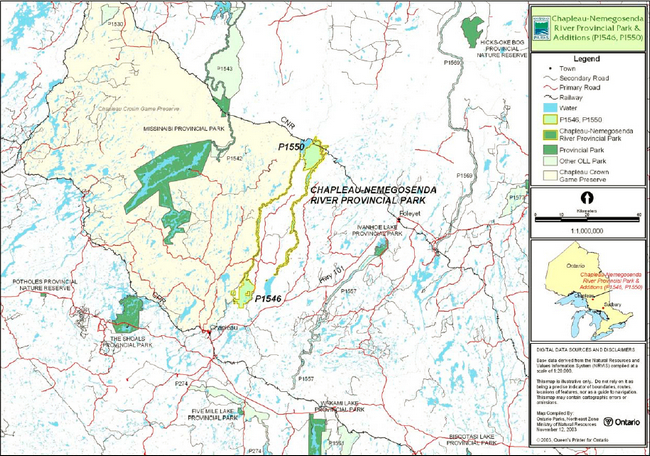
Chapleau-Nemegosenda River Provincial Park is located approximately 100 kilometers west of Timmins. Chapleau is located approximately fifteen kilometers southwest of the park (Figure 1).
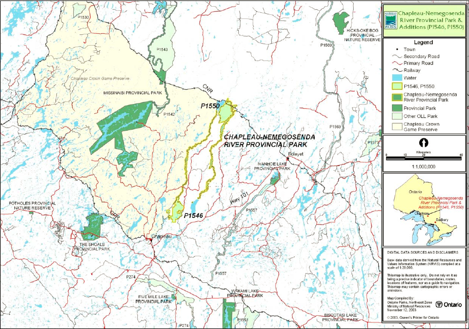
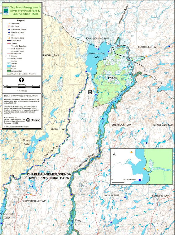
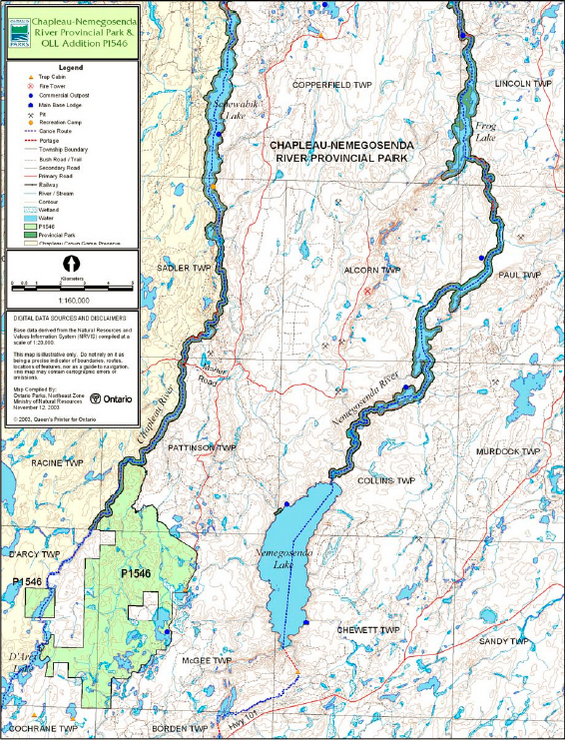
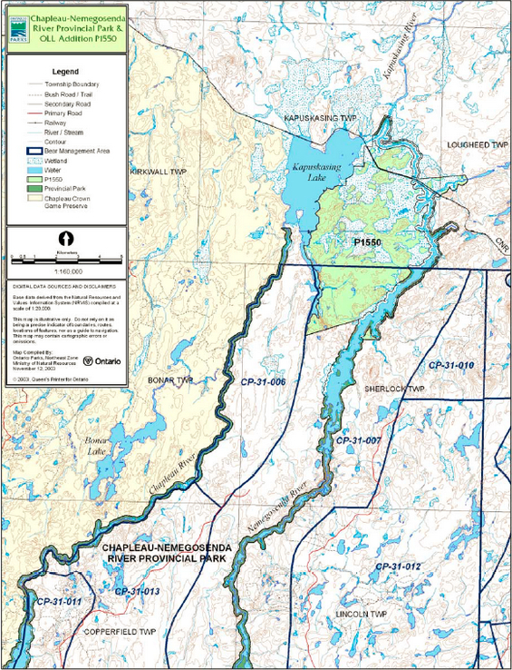
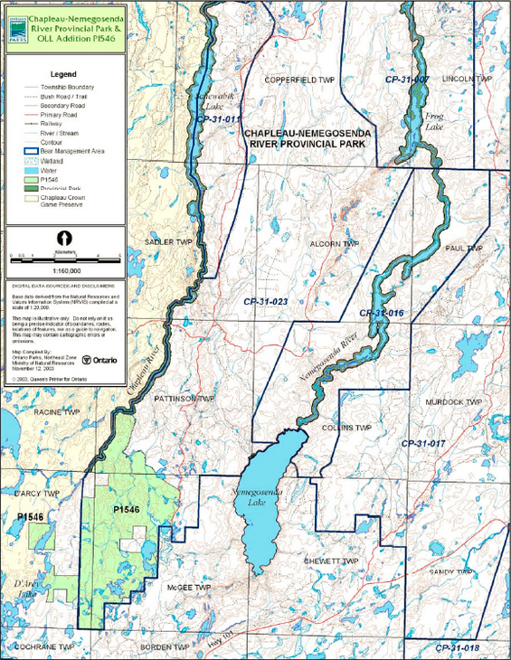
The boundaries of the original Chapleau-Nemegosenda River Provincial Park are 120 meters perpendicular to the high water mark along the shores of the Chapleau River, Schewabik Lake, Nemegosenda River, Nemegosenda Lake, Alcorn Lake and Frog Lake. Chapleau-Nemegosenda River Provincial Park Addition (P1546) is located at the southern boundary of the original Chapleau-Nemegosenda River Provincial Park. This addition lies to the south-east of the Chapleau River in Pattison, McGee and D’Arcy townships. The Nemegosenda River Wetlands Provincial Park Addition (P1550) is located at the north end of the original park. Most of the addition lies in Kapuskasing and Sherlock townships between Kapuskasing Lake and the Nemegosenda River with a small portion located in Lougheed Township, along Lougheed Creek (Figure 2a and Figure 2b).
The original park was regulated in 1973 and amended in 1980 and 1985 to include a total of 8,165 hectares. Nemegosenda River Wetlands Provincial Park Addition was regulated in 2003, adding 6,179 hectares to the original park. The regulated 2005 area of Chapleau-Nemegosenda River Provincial Park Addition adds 4,790 hectares, bringing the total park land base to 19,134 hectares.
The purpose of this Interim Management Statement (IMS) is to provide direction to ensure custodial management of park resources. If deemed necessary, a park management planning process may be conducted at a future date. At that time, significant decisions regarding resources stewardship, operations, development and permitted uses are made.
1.1 Objectives
Chapleau-Nemegosenda River Provincial Park and its additions will be managed consistent with the four objectives for provincial parks:
Protection:
To protect provincially significant elements of the natural and cultural landscapes of Ontario.
Recreation:
To provide provincial park outdoor recreation opportunities ranging from high-intensity day-use to low-intensity wilderness experiences.
Heritage appreciation:
To provide opportunities for exploration and appreciation of the outdoor natural and cultural heritage of Ontario.
Tourism:
To provide Ontario’s residents and out-of-province visitors with opportunities to discover and experience the distinctive regions of Province.
2.0 Management context
Park management will follow direction from:
- Ontario’s Living Legacy Land Use Strategy (OMNR 1999) and related policy clarification documents (OMNR 2000)
- Ontario Provincial Parks Planning and Management Policies (OMNR 1992)
- Ontario Crown Land Use Policy Atlas (OMNR 2004a)
- Provincial Parks Act (OMNR 1990).
Custodial management will protect park values and ensure public health and safety in the park. Ontario Parks will ensure that policy and Environmental Assessment Act (1990) requirements are implemented.
2.1 Environmental Assessment
As part of the Ontario Ministry of Natural Resources, Ontario Parks is a public sector agency that is subject to the Environmental Assessment Act. Management of the waterway park will be carried out in accordance with legislation, policies and guidelines that are required under the MNR’s A Class Environmental Assessment for Provincial Parks and Conservation Reserves (OMNR 2005a).
Figure 1: Regional Setting Map
Enlarge Figure 1: Regional Setting Map
Figure 2a: Park Boundary
Enlarge Figure 2a: Park Boundary
Figure 2b: Park Boundary
Enlarge Figure 2b: Park Boundary
3.0 Park features and values
Approximately 19,134 hectares of Crown land are protected within the boundaries of the original Chapleau-Nemegosenda River Provincial Park and the two park additions. The park and additions are classified as waterway. Waterway class parks protect outstanding recreational water routes and provide high quality recreational and educational opportunities.
3.1 Geological Features
The Chapleau and Nemegosenda Rivers lie within the Kapuskasing Belt Subprovince of the Superior structural province. The bedrock of the Superior Province includes some of the oldest rock on the Precambrian Canadian Shield with ages ranging from 2.5 to 3.4 billion years.
The geology along the Chapleau River is dominated by foliated to gneissic intrusive rocks. The bedrock geology along the Nemegosenda River includes roughly equal amounts of gneissic intrusives (granulite facies) and metasedimentary rocks with only a minor component of metavolcanics (Geomatics 1993).
The surficial geology of the Chapleau-Nemegosenda River Provincial Park is dominated by wide expanses of exposed bedrock and thin sandy to silty till overlying bedrock (Geomatics 1993). The central portions of both rivers flow through glaciofluvial ice-contact deposits which are part of larger esker complexes in the area.
The bedrock of both park additions was determined to be characteristic of the Chapleau Block in the Kapuskasing Structural Zone, components of the eastern Wawa Subprovince in Archean Superior Province. The Chapleau-Nemegosenda River Provincial Park Addition consists mainly of mafic migmatite bedrock exposures. The Nemegosenda River Wetlands Provincial Park Addition contains mainly felsic to mafic intrusives and melanocratic granulite bedrock exposures (Frey and Duba 2002a).
The surficial geology of Chapleau-Nemegosenda River Provincial Park Addition is predominantly silty to sandy till of ground moraine. The till consists of mixed pebbles to boulders. The glaciofluvial deposits are rare south-trending eskers that have generally not been modified since their formation. The south-eastern part of the addition is covered by glaciolacustrine sand deposits. The surficial geology of this addition is of local significance (Frey and Duba 2002b).
The Nemegosenda River Wetlands Provincial Park Addition is predominantly covered by glaciolacustrine deposits of massive or varved clay and silt. Silty and sandy till ground moraine is located in the southern part of the addition. The quaternary geology of the Nemegosenda River candidate Area of Natural and Scientific Interest (ANSI), a large portion of which is included in this addition, includes contrasting representations of several major glacial events of the Wisconsinan period. This area represents a transitional site between the Great Clay Belt to the north and the extensive till/outwash deposits more characteristic of the height of land area to the south (Ecological Services for Planning 1991).
3.2 Biological Features
The vegetation of the original park include aquatic communities, sand and cobble shorelines, wetlands and boreal forest communities (successional forest, riparian White Cedar, mixed coniferous forest, Black Spruce forest, and Jack Pine forest). There are also infrequent occurrences of the following communities; patterned fen, deciduous swamp, upland Black Spruce forest, White and Red Pine forests, and communities on exposed bedrock or on cliffs (Geomatics 1993).
The life science features of the Nemegosenda River Wetlands candidate ANSI were investigated and inventoried in 1991 (Ecological Services for Planning 1991). The addition contains landform and vegetation combinations that are not well represented in other protected areas within Ecodistrict 3E-5. As such, they were designated as provincially significant. Both provincially significant landform-vegetation types were wetlands. The more extensive of the two were the patterned fens (organic peat lands) on the western side of the Nemegosenda River, which were among the most southern, extensive, and diverse examples of this landform-vegetation type within Ecoregion 3E. The other significant wetland is a smaller fen on glaciofluvial ice contact terrain in the south-west corner of the unit. These landform-vegetation combinations were determined from aerial photography (Morris 2003a).
The Nemegosenda River Wetlands Addition includes representations of at least eight forest ecosites (Taylor 2000), dominated by Black Spruce, Trembling Aspen, Larch, or Eastern White Cedar. Common subordinate species included White Spruce, White Birch, and Balsam Fir. Black Ash and Balsam Poplar were lowland hardwood species which occurred frequently on moist, mineral soils, but not as distinct, stand forming species. The majority of the forest stands in the addition were classified as old-growth or old-mature (Morris 2003a; Uhlig et al. 2001), although there are a few, relatively small recent burns as well. As the addition contains very few human disturbances, the site contains large tracts of interior forest habitats as well as natural forest edge ecotone habitats. The site includes a known Bald Eagle breeding site.
An investigation of the biological features of Chapleau-Nemegosenda River Park Addition has not been completed at this time. This addition contains some areas of interior forest habitat (Morris 2003b).
3.3 Cultural setting
A detailed inventory of the cultural features of the existing provincial park or its additions has not been completed at this time. Within the existing park, there are several known culturally significant areas. Known cultural sites include a pictograph on the east shore of the Chapleau River and a possible native cemetery on Frog Lake. There are no known archaeological sites in the original park; however findings in areas in close proximity to this park would suggest that this system may have been used as a travel route by prehistoric people.
Any future planning will be done within the context of a provincial framework, A Topical Organization of Ontario History (OMNR 1974). In addition, updates and discussions with First Nations, other agencies and stakeholders may be carried out to identify cultural heritage values and features within the park and their significance. This information may be used to develop management guidelines to conserve and protect representative archaeological and historical values and features, or to provide direction for further research.
3.4 Recreation
There are no developed recreational facilities. The park provides backcountry camping, canoeing and fishing opportunities. Commercial tourism facilities outside the park generally cater to anglers and to a limited degree, to hunters. The use of motor boats for sport fishing is generally associated with outpost camps. Hunting occurs within the park excluding those areas within the Chapleau Game Preserve.
Existing recreational activities are also likely to occur in the park additions. Other recreational activities that may occur include wildlife viewing, photography and self-guided exploration of park features.
4.0 Aboriginal use
Chapleau-Nemegosenda River Provincial Park and additions are within the Nishnawbe Aski Nation Treaty 9 Area (1905-06). Nearby aboriginal communities include the Chapleau Cree, Chapleau Ojibwe and Brunswick House Indian Reserves.
First Nation communities have expressed interest in and have shared knowledge of the park and surrounding area. Aboriginal communities have used the area for hunting, trapping, fishing, gathering and travel. These uses may continue, subject to public safety, conservation and other considerations.
Any communications or cooperation between aboriginal communities and MNR for planning and operations purposes will be done without prejudice to any future discussions or negotiations between the Government of Ontario and aboriginal communities.
5.0 Stewardship policies
The removal, damage or defacement of Crown property, natural objects, relics and artifacts is not permitted in provincial parks (Provincial Parks Act 1990).
5.1 Terrestrial ecosystems
5.1.1 Vegetation
Harvesting
Commercial forest harvesting and renewal activities are not permitted within the park (OMNR 1992; 1999; 2004a).
New commercial harvesting of non-timber forest products (e.g. wild rice, Canada yew) will not be permitted within the boundary of Chapleau-Nemegosenda River Provincial Park and additions (OMNR 2004a).
There are no fuelwood cutting permits currently issued for the park. No new permits will be issued (OMNR 2000; 2004a).
Non-native plants
Non-native plants species will not be deliberately introduced into the park. Where non-native plant species are already established and threaten park values, a strategy may be developed to control the species (OMNR 1992).
Insects and disease
Insects and diseases may be managed where the park’s aesthetic, cultural or natural values are threatened (OMNR 1992).
Control methods will follow guidelines established by the Ontario Ministry of the Environment (MOE) and MNR. Biological controls, in preference to chemicals, will be used whenever possible (OMNR 1992).
Fire
Chapleau-Nemegosenda River Provincial Park and additions are located within MNR’s Boreal Fire Management Zone. In accordance with existing provincial park policy and the Forest Fire Management Strategy for Ontario (OMNR 2004b), forest fire protection will be carried out in Chapleau-Nemegosenda River Provincial Park and additions as on surrounding lands.
Whenever feasible, MNR’s Forest Fire Management program will use techniques which minimize damage to the landscape during response efforts (OMNR 2004b).
5.1.2 Wildlife management
The park is located in Wildlife Management Unit (WMU) 31 with a small portion located in WMU 30. The Chapleau River portion of the park follows the boundary of WMU 32. The removal or harassment of non-game animals is not permitted in provincial parks (Provincial Parks Act 1990).
Status Indians exercising treaty rights are permitted to hunt and trap within Chapleau-Nemegosenda River Provincial Park and additions (OMNR 1992; 2000).
Hunting
Sport hunting is permitted to continue within the boundary of Chapleau-Nemegosenda River Provincial Park and the park additions. Hunting is not permitted along the west shore of the Chapleau River; this area lies within the Chapleau Game Preserve where hunting is prohibited.
The Fish and Wildlife Conservation Act (1997), as well as the Federal Migratory Birds Convention Act (1994), governs any hunting activity within the park. The Ontario Hunting Regulations Summary contains regulations specific to this area. The harvest of bullfrogs or snapping turtles is illegal in provincial parks (OMNR 2005b).
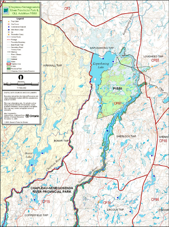
Bear management areas
The original Chapleau-Nemegosenda River Provincial Park and additions include portions of six licensed bear management areas (BMAs) (Figure 3a and Figure 3b)
In relation to the original park boundary, hunting is permitted; however, it is an activity that may be reviewed during future park management planning, with public consultation (OMNR 1991).
Hunting, including commercial bear hunting, is permitted to continue in this provincial park, but may be subject to conditions identified during future park management planning, such as the designation of nature reserve zones. No new BMA licences will be issued. Renewal and transfer of existing licences will consider conservation principles and public safety (OMNR 2000; 2004a).
Trapping
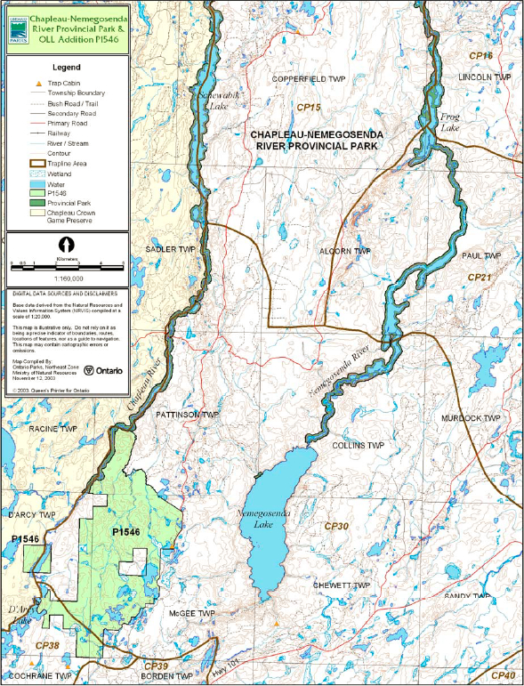
The original park and its additions include portions of seven licensed trap lines (Figure 4a and Figure 4b). Trapping is not permitted in the Chapleau Game Preserve located along the western shore of the Chapleau River.
One trap cabin is located on the Nemegosenda River within the original park. Another trap line and an associated trap cabin are located within Chapleau-Nemegosenda River Provincial Park Addition on the east side of Sauce Lake.
Existing commercial fur harvesting will be permitted to continue indefinitely, but may be subject to conditions identified during future park management planning, such as the designation of wilderness or nature reserve zones.
New operations including trap line cabins and trails will not be permitted. The relocation of existing trails and cabins will be subject to ecological principles and management planning (OMNR 2003).
“Existing use” is defined as use that is supported by an active license, permit or other formal authorization. If this authorization lapses the activity is no longer considered an existing use (OMNR 2000).
Transfers of active trap line licenses are permitted, subject to a review of potential impacts and the normal transfer or renewal conditions that apply.
5.1.3 Industrial resources
The extraction of sand or gravel is not permitted within the park. There are no active aggregate pits within the park. An active Ministry of Transportation (MTO) aggregate pit is located adjacent to the park in Jocko Township.
Mineral exploration and mining are not permitted in provincial parks. In accordance with Ontario’s Living Legacy Land Use Strategy (OMNR 1999), access through the park to mining lands (i.e. forest reserves and mining patents) will be permitted for purposes of mineral exploration, development or operations. Access will be planned in accordance with the requirements of the Environmental Assessment Act.
There are no existing mining claims within Chapleau-Nemegosenda River Provincial Park. All lands within the park have been withdrawn from mining activity under the Mining Act (1990).
5.1.4 Access and crossings
Access
The original Chapleau-Nemegosenda River Provincial Park has been traditionally accessed via road, railway and water. There are no designated access points developed within the original park. Road access in the original park is limited to two logging roads, one crossing the Chapleau River (Martel Road) and one to the southwest corner of Schewabik Lake.
The original park can be accessed via several waterway routes. As an alternative access to the Chapleau River, the access point on Racine Lake is used to a limited degree. Canoeists paddle along Racine Creek to enter the southern end of the park on the Chapleau River. Access to the Nemegosenda River is via Highway 101 starting at Borden Lake, through Emerald, Le-Blanc, Westover, Waweya and Mate lakes and the Borden River. Most of the land bordering these water bodies is patented.
Figure 3a: Bear Management Areas
Enlarge Figure 3a: Bear Management Areas
Figure 3b: Bear Management Areas
Enlarge 3b: Bear Management Areas
Figure 4a: Trap Line Areas
Enlarge Figure 4a: Trap Line Areas
Figure 4b: Trap Line Areas
Enlarge Figure 4b: Trap Line Areas
Kapuskasing Lake offers access to both the Chapleau and Nemegosenda rivers. The Chapleau-Nemegosenda River Provincial Park Addition is accessible by forest access roads along its eastern boundary. The western block of this addition is accessible by water, via the Chapleau River. The interior area of this addition is not easily accessed.
The Nemegosenda River Wetlands Provincial Park Addition is accessed via water from Kapuskasing Lake and the Nemegosenda River. The Canadian National Railway (CNR) travels through the northern area of this addition and could potentially provide a means of access to this area. Road access to this addition is limited. A seasonal road from the hamlet of Elsas enters the north end of the addition.
Access to the park and additions will be permitted to continue. Access to the original park will be permitted as follows: water access via Kapuskasing Lake to either Chapleau or Nemegosenda rivers; Racine Lake via Racine Creek to the Chapleau River; Borden Lake via waterway to the Nemegosenda River; road access on the Chapleau River in Pattison Township; and road access to the southwest corner of Schewabik Lake (OMNR 1991). Access to the additions will remain the same.
Roads
Several roads cross the park and park additions boundaries. Two logging roads cross the pre-1999 Chapleau-Nemegosenda River Provincial Park; one crosses the Chapleau River (Martel Road) and one provides access to the southwest corner of Schewabik Lake. A seasonal track road from the hamlet of Elsas enters the north end of the Nemegosenda River Wetlands Park Addition. The Chapleau-Nemegosenda River Addition is accessible by forest access roads along its eastern boundary.
The Martel forest access road which crosses the Chapleau River in Pattison Township will be the only authorized road crossing of the pre-1999 park boundary (OMNR 1991).
Where existing forest access roads are essential for continued access beyond the park for forest management or recreation purposes, alternative road access does not exist, and road relocation is not feasible, existing roads will continue to be available for access. Continued use will include maintenance and may include upgrading. Ontario Parks is not responsible for maintenance or upgrading of any existing roads within the park boundary. The same is true for other existing roads that are essential for continued access to in-holdings (e.g. LUPs, patent land). For example, an existing old logging road north of Adams Lake through the P1546 park addition is required to access privately owned land northwest of Adams Lake. This road will continue to be available as a tertiary winter road.
New roads crossings of the waterway park may be necessary to maintain essential public services and commercial forest operations outside of the park boundaries. The number of crossings will be minimized where possible and will be managed to reduce their impact on recreational and aesthetic values. Any future road crossings proposed through the park, where park lands are unavoidable, will be reviewed on a case-by-case basis. Protection of park values will be priority and must meet all requirements of the Environmental Assessment Act.
Any proposed development, maintenance or upgrading of existing roads must meet all Environmental Assessment Act requirements.
Since aggregate extraction is not permitted within the park, an external source of aggregate is required for road improvements and maintenance.
Railway
The CNR corridor crosses the Nemegosenda River Wetlands Addition. There are no other railway crossings of the park or additions.
New railway crossings of the waterway park may be necessary to maintain essential public services outside of the park boundaries. The number of future crossings will be minimized where possible and they will be managed to reduce their impact on recreational, aesthetic, cultural and biological values (OMNR 1992).
Utility corridors
No utility corridors cross the boundary of the park or additions.
New utility corridor crossings may be necessary to maintain essential public services (OMNR 1992; OMNR 2004a). The number of new crossings will be minimized where possible and will be managed at to reduce their impact on recreational, biological, cultural and aesthetic values (OMNR 2004a).
Any future utility corridors proposed through the park, where park lands are unavoidable, will be reviewed on a case-by-case basis. Protection of park values will be priority. MNR’s Environmental Assessment requirements must be met.
Recreational trails
Canoe Route: The Chapleau-Nemegosenda River canoe route begins in Chapleau along Highway 129 and travels north on the Chapleau River, Henderson Lake, D’Arcy Lake, Robinson Lake, Racine Lake, Schewabik Lake, and Kapuskasing Lake. At this point, the route travels south on the Nemegosenda River, Frog Lake, Nemegosenda Lake, Borden River, Mate Lake, Westover Lake, Leblanc Lake, Emerald Lake, and Borden Lake. A portage to Mulligan’s Bay leads to the Chapleau River, where the trip concludes in Chapleau. This canoe route offers several areas of white water in a remote setting. The total route length is 236 kilometers.
Hiking: There are no designated hiking trails in the park or additions at this time.
Snowmobile Trails: There are no designated snowmobile trails in Chapleau-Nemegosenda River Provincial Park and additions at this time.
ATV Trails: There are no designated all-terrain vehicle trails in the park or additions.
5.1.5 Adjacent land management
Forestry
The lands adjacent to the park and additions are allocated to the Gorden Cosens Forest management unit (FMU 438) and the Pineland Martel Forest management unit (FMU 765). Tembec Forest Resources Management (Kapuskasing) carries out forest management planning on the Gorden Cosens Forest under the authority of the Spruce Falls Inc. sustainable forest licence (SFL). The forest management plan was renewed in 2005 (OMNR 2005c).
Tembec currently manages the Pineland Martel Forest. The current forest management plan is to be renewed in 2006 (OMNR 2005c).
Chapleau game preserve
The Chapleau Crown Game Preserve is located west of Chapleau-Nemegosenda River Provincial Park. Established in 1925, the preserve is approximately 700,000 hectares in area and has served as a wildlife research area for many years. Hunting and trapping are not permitted within the boundary of the game preserve.
No-Cut Reserve
Along the pre-1999 park boundary there is an 80 metre no-cut reserve adjacent to the 120 metre park boundary (OMNR 1991). This no-cut reserve will be identified in all timber management plans (OMNR 1991).
Adjacent tourism facilities
Two lodges are located near the park. Kingfisher Lodge is located adjacent to the Nemegosenda River Wetlands Provincial Park Addition on Kapuskasing Lake. Quigley’s Do Little Inn is located in Elsas on the northern shore of Kapuskasing Lake. This lodge is accessible by train or water only and caters primarily to anglers.
General use areas
There are two general use areas adjacent to the park and additions. One is a 1,495,186-hectare general mixed use area of significant mining and forestry potential intermixed with local recreation and tourism. The other is a 9,294-hectare waterway recreation corridor which includes portions of water bodies to the north and south of the park. The primary use of these waterway areas is recreation.
5.1.6 Land disposition
No new land disposition for the private use of individuals or corporations will be permitted (OMNR 1992, 2000a).
Land use permits, licenses of occupation, unauthorized occupations
There are six commercial outpost camp LUPs within the park and park additions. Five of the LUPs are located within the pre-1999 park boundary; the sixth is within Chapleau-Nemegosenda River Park Addition. (Figure 4a and Figure 4b).
There is one LUP for the logging road that crosses the Chapleau River in Pattison Township (OMNR 1991).
There is one private recreation camp LUP within the pre-1999 park boundary. This permit will be phased out by January 01, 2010 (OMNR 1992).
Patent land
Within the original park area, there is one parcel of patent land. This 0.7 hectare parcel is located on the east shore of Schewabik Lake and is used for private recreation. The patent land does not include the 20.12 meter shoreline reserve (OMNR 1991).
Surrounded by the Nemegosenda River Wetlands Provincial Park Addition there is one cottage site, located on a parcel of patented land on the south-eastern side of Kapuskasing Lake.
The Scierie Landrienne Inc. patent northwest of Adams Lake is surrounded by the Chapleau-Nemegosenda River Provincial Park Addition (P1546).
These parcels of patent land are not included within the park and as such the policies and legislation of the Provincial Parks Act do not apply to these lands.
Boat caches
There are no authorized boat caches located within the park.
Watercraft are not permitted to be left unattended in the park without written permission from the park superintendent (OMNR 1990).
5.2 Aquatic ecosystems
Sustaining quality water resources is integral to the protection of park and adjacent lands values. The Ontario Ministry of Environment (MOE) enforces applicable legislation and regulations for water quality.
5.2.1 Water management
There is currently no water management plan which governs the waters of the Chapleau River or the Nemegosenda River.
There are no existing water control structures within Chapleau-Nemegosenda River Provincial Park or additions.
New water control or hydroelectric developments are not permitted within the park or additions (OMNR 1992; 2000).
5.2.2 Fisheries management
The waters within Chapleau-Nemegosenda River Provincial Park and additions support walleye, northern pike and lake whitefish populations. Lake trout and brook trout are also found in the area.
Fisheries management will complement the maintenance and enhancement of native, self-sustaining fish populations.
Non-native fish
Non-native fish species will not deliberately be introduced into the waters within Chapleau-Nemegosenda River Provincial Park or additions (OMNR 1992).
Sanctuaries
There are currently no fish sanctuaries within the park or additions. Certain water bodies may be closed to fishing temporarily or permanently for fisheries research or management purposes (OMNR 1992).
5.2.3 Sport fishing
Sport fishing (including ice fishing) is permitted within the park, subject to the Fish and Wildlife Conservation Act and the Fisheries Act. The Recreational Fishing Regulations Summary (Northeastern, Division 19) contains details on regulations and exceptions to those regulations for this area (OMNR 2005d).
5.2.4 Commercial fishing
There are no commercial fishery operations within the original park or the additions. No new operations will be permitted (OMNR 2003).
5.2.5 Commercial baitfish harvesting
The pre-1999 park boundary does not have any commercial baitfish harvesting operations. No new commercial bait fish operations will be permitted (OMNR 2003).
D’Arcy, Pattison and Lougheed townships are currently allocated for baitfish harvesting. Existing bait harvesting will be permitted to continue indefinitely within the park additions, but may be subject to conditions identified during future park management planning (OMNR 2000). New baitfish licenses will not be issued within park boundaries (OMNR 2004a).
5.2.6 Fish stocking
The stocking of native fish species may be considered through park management planning. The stocking of non-native fish species will not be considered (OMNR 2004a).
6.0 Operations policies
6.1 Recreation management
Future planning, with full public consultation, will review direction on motorized and non-motorized recreation uses.
6.1.1 Motorized recreation
Motorboats
Existing use may continue unless park features or values are threatened. Long-term management direction for private and commercial boat use may be determined through future park management planning (OMNR 2004a).
Snowmobiles
There are currently no authorized snowmobile trails within the park.
Snowmobile use on established routes for access to private land in-holdings, LUPs or recreational ice fishing may be authorized to continue if determined that such use does not conflict with the protection of park values or other recreational pursuits.
Off-trail snowmobile use is prohibited unless authorized by the superintendent under the authority the Provincial Parks Act and consistent with provincial park policy.
All-terrain vehicles
There are currently no authorized all-terrain vehicle (ATV) trails located within the park.
The use of ATVs on established trails for access to private land in-holdings and land use permit areas is permitted to continue. New ATV trails may only be considered subject to future park management planning with public consultation (OMNR 2000).
Off-road use of ATVs is prohibited unless authorized by the superintendent under the authority the Provincial Parks Act and consistent with provincial park policy.
Aircraft
Aircraft access in waterway parks is limited to specific zones as may be defined through future planning (OMNR 1992). All aircraft landings are subject to regulation and valid aircraft landing permits issued by the park superintendent.
6.1.2 Non-motorized recreation
Camping
Day-use and backcountry camping activities associated with the waterway environment will be encouraged (OMNR 1992).
Existing use may continue unless park values are threatened (OMNR 2004a). Infrastructure to protect the park features and values will be permitted and developed in response to use, environmental deterioration and environmental protection requirements. Any development must meet the requirements of the Environmental Assessment Act.
Hiking
There are no developed hiking trails within the park or additions.
If there is an identified need, new hiking trail development may be considered. Trail infrastructure to protect park values and features will be permitted. New trail development is subject to the requirements of the Environmental Assessment Act.
Canoeing/kayaking
Existing canoeing and kayaking use may continue, unless park values are threatened (OMNR 2004a). Infrastructure to protect park features and values will be permitted.
6.1.3 Emerging recreational uses
There are emerging recreational uses for which there is limited or no policy to deal with their management (e.g. adventure racing, geocaching, etc). The park superintendent will use legislation, policies and guidelines which are in place in the interim to manage emerging uses.
6.2 Development
There is no existing park infrastructure within the park. Infrastructure to protect park features and values will be permitted and developed in response to use, environmental deterioration and environmental protection requirements. All development must meet the requirements of the Environmental Assessment Act.
6.3 Commercial tourism
There are currently six LUPs issued for commercial tourism use within Chapleau-Nemegosenda River Provincial Park and additions.
Commercial tourism may continue as a permitted use in the original Chapleau-Nemegosenda River Provincial Park (OMNR 1991). Within the original park boundary, new commercial land use permits, or decisions to expand or relocate within the original park boundary, may occur provided that the proposed commercial use can be demonstrated to be complementary to the park’s goal and objectives.
The relocation or reconstruction of an existing commercial LUP may be considered if the facilities have been destroyed by natural causes (OMNR 1991). The reconstructed structure is not to be expanded in size or guest capacity from the original structure (OMNR 1991). If relocation occurs, the new location must be approved by MNR and all Ministry policies must be adhered to (OMNR 1991).
Existing authorized tourism facilities within the park additions are permitted to continue, but are subject to management prescriptions determined through management planning (OMNR 2004a).
New commercial tourism facilities and trails may be considered where consistent with park policy (OMNR 2004a). Any proposed development within park boundaries must fulfill the requirements of the Environmental Assessment Act.
7.0 Cultural resources
No assessment of the cultural resources of the original park or additions has been completed at this time. Management of any cultural values within this park will be directed toward protection and heritage appreciation (OMNR 1992).
8.0 Heritage education
Basic literature and support information may be developed to describe Chapleau-Nemegosenda River Provincial Park and park additions in the context of Ontario’s provincial park system. Boundary limits, significant heritage features and permitted uses within the waterway park may be included in park literature.
Prospective park visitors may be informed about the sensitivity and significance of park values through park literature. Visitors may also be informed about the presence of, and need to respect, adjacent private lands through park literature.
9.0 Research
Scientific research by qualified individuals, which contributes to the knowledge of natural and cultural history or to environmental and recreational management, will be encouraged in the park and the park additions. Ontario Parks will encourage institutions to undertake research projects. All research programs will require the approval of Ontario Parks and are subject to park policy and other applicable legislation. Ontario Parks may approve the research of any natural or cultural features or values by qualified researchers. Any materials removed will remain the property of Ontario Parks.
Approved research activities and facilities will be compatible with the park’s protection objective. Any site which is affected will be rehabilitated as closely as possible to its original state. Environmental Assessment Act requirements will apply.
10.0 References
Ecological Services for Planning (ESP), 1991. Report on Reconnaissance Life Science Inventory for Nemegosenda River Wetlands Area of Natural and Scientific Interest.
Frey, D. Duba., 2002a. P1550 Nemegosenda River Wetlands Park Addition (Earth Science Checksheet-Draft).
Frey, D. Duba., 2002b. P1546 Chapleau-Nemegosenda River Provincial Park Addition (Earth Science Checksheet-Draft).
Geomatics International Incorporated (Geomatics), 1993. A Biological Inventory and Evaluation of Chapleau-Nemegosenda Rivers Waterway Provincial Park.
Environmental Assessment Act, 1990.
Fish and Wildlife Conservation Act, 1997.
Harper, T. 2003. Chapleau-Nemegosenda River Provincial Park Addition (P1546) Recreation Assessment Inventory Report Version 1.1. (Draft)
Harper, T., 2003. Nemegosenda River Wetlands Provincial Park Addition (P1550) Recreation Assessment Inventory Report Version 1.1. (Draft)
Mining Act, 1990.
Morris, E., 2002. Inference Key to Forest Ecosites from Digital FRI Data: Northeast Zone Site Regions 3E to 6E.
Morris, E., 2003a. P1550-Nemegosenda River Wetlands Provincial Park Addition Natural Heritage Checksheet.
Morris, E., 2003b. Chapleau-Nemegosenda River Provincial Park Addition (P1546) (Preliminary Mapping).
Ontario Ministry of Natural Resources, 1974. A Topical Organization of Ontario History. Historic Sites Branch Division of Parks.
Ontario Ministry of Natural Resources, 1991. Chapleau-Nemegosenda River Provincial Park Interim Management Statement.
Ontario Ministry of Natural Resources, 1992. Ontario Provincial Parks Planning and Management Policies.
Ontario Ministry of Natural Resources, 1999. Ontario’s Living Legacy Land Use Strategy. Ontario Ministry of Natural Resources, 2000. Ontario’s Living Legacy Land Use Strategy (Policy Clarification).
Ontario Ministry of Natural Resources, 2001. Trapping in new OLL Parks.
Ontario Ministry of Natural Resources, 2003. Directions for Commercial Resource Use Activities in Provincial Parks and Conservation Reserves. 5 pp.
Ontario Ministry of Natural Resources, 2004a. Crown Land Use Policy Atlas.
Ontario Ministry of Natural Resources, 2004b. Forest Fire Management Strategy for Ontario.
Ontario Ministry of Natural Resources, 2005a. A Class Environmental Assessment for Provincial Parks and Conservation Reserves.
Ontario Ministry of Natural Resources, 2005b. Hunting Regulations Summary.
Ontario Ministry of Natural Resources, 2005c. List of Forest Management Units and Forest Management Plan Renewal Schedule 2005.
Ontario Ministry of Natural Resources, 2005d. Recreational Fishing Regulations Summary.
Taylor, K.C.,R.W. Arnup, B.G. Merchant, W.J. Parton, and J. Nieppola. 2000. A Field Guide to Forest Ecosystems of Northeastern Ontario. 2nd Edition.
Uhlig, P., A Harris, G. Craig, C. Bowling, B. Chambers, B. Naylor and G. Beemer. 2001. Old Growth Forest Definitions for Ontario.
Pesticides Act RSO, 1990.
Provincial Parks Act RSO, 1990.
Appendix A: Background information
| Name | Chapleau-Nemegosenda River Provincial Park Nemegosenda River Wetlands Park Addition P1550 Chapleau-Nemegosenda River Provincial Park Addition P1546 |
|---|---|
| Classification | Waterway |
| Ecoregion/Ecodistrict | 3E-5 (Foleyet) |
| OMNR Administrative Region/District | Northeast – Chapleau |
| Total Area (ha) | Pre 1999 Park – 8,165ha Nemegosenda River Wetlands – 6,179 ha Chapleau-Nemegosenda River Park Addition – 4,790 ha Total – 19,134 ha |
| Regulation date & Number | Pre 1999 Park- 1973 (O. Reg. 46/73), 1980 (O.Reg. 821/80), 1985 (O.Reg. 493/85) Nemegosenda River Wetlands – 2003 (O. Reg. 210/03) Chapleau-Nemegosenda River Park Addition – 2005 (O. Reg. 180/05). |
Representation
Earth science:
There has been no extensive investigation or inventory of the earth science features of the provincial park (area regulated prior to July 1999) completed, however a brief description of features was included in the Biological Inventory and Evaluation of Chapleau-Nemegosenda River Waterway Provincial Park (Geomatics 1993).
The following is a description of the bedrock features within the original Chapleau-Nemegosenda River Provincial Park boundary (Geomatics 1993):
The park’s surficial geology is dominated by wide expanses of exposed bedrock and thin sandy to silty till overlying bedrock. The central portions of both rivers flow through glaciofluvial ice-contact deposits; these deposits constitute portions of several large esker complexes which trend north-south to northeast-southwest in the area (Geomatics 1993).
The bedrock of both park additions are characteristic of the Chapleau Block in the Kapuskasing Structural Zone, components of the eastern Wawa Subprovince in Archean Superior Province.
The bedrock of Chapleau-Nemegosenda River Park Addition is predominantly mafic migmatite. The bedrock of Nemegosenda River Wetlands Addition is predominantly felsic to mafic intrusives and melanocratic granulite. The bedrock geology of both additions is considered regionally significant.
The surficial geology of Chapleau-Nemegosenda River Park Addition is predominantly silty to sandy till ground moraine. Glaciofluvial deposits are rare, forming elongated, south trending eskers generally unmodified since their formation. The southeastern part of the area is covered by glaciolacustrine sandy deposits. The surficial geology of the addition is locally significant.
The surficial geology of Nemegosenda River Wetlands Addition is predominantly glaciolacustrine deposits of massive or varved clay and silt. Silty to sandy till ground moraine is found in the southern part of the area. On the eastern shore of Kapuskasing Lake an esker runs southward for over 2.5 kilometres along the lake’s southern extremity.
Life science:
The vegetation communities of the pre-1999 park area include aquatic communities, sand and cobble shorelines, wetlands (marshes, thickets, string fens, treed fens, coniferous swamps, and deciduous swamps) and boreal forest communities (successional forest, riparian White Cedar mixed coniferous forest, Black Spruce forest and Jack Pine forest). There are also infrequent occurrences of the following communities; patterned fen, deciduous swamp, upland Black Spruce forest, White Pine and Red Pine forests, as well as communities on exposed bedrock or on cliffs (Geomatics 1993).
The life science features in Nemegosenda River Wetlands candidate Area of Natural and Scientific Interest (ANSI) were inventoried in 1991 (Ecological Services for Planning 1991). This candidate ANSI was included in the Nemegosenda River Wetlands Addition. Morris (2003a) prepared a Life Science Checksheet based on the Ecological Services for Planning’s (1991) earlier work, as well as supplemental analyses. The addition contains landform and vegetation combinations that are not well represented in other protected areas within Ecodistrict 3E-5. As such they were designated as provincially significant. Both provincially significant landform-vegetation types were wetlands. The most extensive of the two are the patterned fens (organic peatlands) on the western side of the Nemegosenda River, which were among the most southern, extensive and diverse examples of this landform-vegetation type within Ecoregion 3E. The other significant wetland is a smaller fen on glacio-fluvial ice-contact terrain in the southwest corner of the unit. The landform-vegetation combinations were determined from aerial photography (Morris 2003a).
The Nemegosenda River Wetlands Park Addition includes representations of at least 8eight forest ecosites (Taylor et al. 2000), dominated by Black Spruce, Trembling Aspen, Larch, or Eastern White Cedar. Common subordinate species included White Spruce, White Birch, and Balsam Fir. Black Ash and Balsam Poplar were lowland hardwood species which occurred frequently on moist, mineral soils, but not as distinct, stand forming species. The majority of the forest stands in the addition were classified as old-growth or old-mature (Morris 2003a; Uhlig et al. 2001), although there are a few, relatively small recent burns as well. As the park addition contains very few human disturbances, the site contains large tracts of interior forest habitats as well as natural forest edge ecotone habitats. The site includes a known breeding location for Bald Eagle.
An in depth investigation of the life science values of the Chapleau-Nemegosenda River Provincial Park Additions has not been completed at this time. Preliminary mapping was developed for this site by Morris (2003b).
Cultural resources:
An in-depth investigation into the cultural features of Chapleau-Nemegosenda River Provincial Park has not been completed; however, there are known cultural resources located within the original park. A pictograph is located on the east shore of the Chapleau River. A First Nation cemetery is located on Frog Lake.
Recreation & tourism:
Chapleau-Nemegosenda River Provincial Park supports backcountry canoeing, camping and fishing. Hunting also occurs within the park, excluding those areas within the Chapleau Game Preserve. Sport fishing and motor boating also occur in the park. Photography, solitude, and self-guided interpretation of the earth and life science features are activities that may also be supported in this park.
Six existing land use permits (LUP) are located within the original park allocated for commercial outpost and private recreation purposes. There is one LUP (commercial outpost) located in Chapleau-Nemegosenda River Provincial Park Addition. The Nemegosenda River Wetlands Park Addition does not contain any LUPs.
There are two lodges in the vicinity of the park. Kingfisher Lodge and Quigley’s Do Little Inn are located on private land adjacent to the park.
Inventories
| Survey Type | Earth Science | Life Science | Cultural | Recreational |
|---|---|---|---|---|
| Reconnaissance | Addition – Frey and Duba, 2002 | Ecological Services for Planning, 1991; Geomatics, 1993; Morris, 2003a |
Harper, 2003 |
Footnotes
- footnote[1] Back to paragraph Transfers include situations where a license is surrendered with a request that it be immediately reissued to another individual or organization that is assuming an existing operation. Trap cabins are considered part of a trapline and would be transferred with the trapline for the purposes of trapping. If a trapline license is revoked or surrendered, all portions of the registered line within the park will be rescinded from the legal description of the trap line (OMNR 2001).