Chiniguchi Waterway Provincial Park Management Statement
This document provides direction on the management of Chiniguchi Waterway Provincial Park.
Waterway
Interim Management Statement
2007
Approval statement
I am pleased to approve this Interim Management Statement for Chiniguchi Waterway Provincial Park. Ontario’s Living Legacy Land Use Strategy (1999) has identified this area as a waterway class provincial park. This park was regulated under the Provincial Parks Act in June 2006 (O. Reg. 331/06).
This Interim Management Statement provides direction for the protection and management of Chiniguchi Waterway Provincial Park.
Signed by:
Paul Bewick
Zone Manager
Northeast Zone
Ontario Parks
Date: February 12, 2007
1.0 Introduction
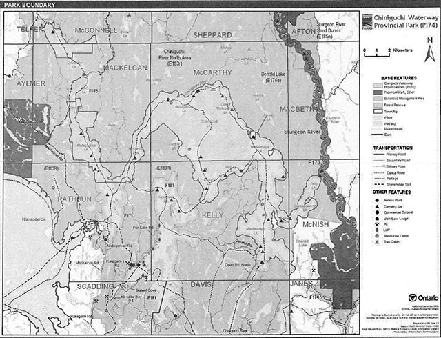
Chiniguchi Waterway Provincial Park is located approximately 50 kilometres northeast of the City of Greater Sudbury (Figure 1). The park crosses the geographic townships of MacKelcan, Rathbun, McCarthy, Kelly, McConnell and McNish encompassing 9,368 hectares of Crown land (Figure 2). The park was regulated on June 20, (O. Reg. 331/06).
Chiniguchi Waterway Provincial Park (P174), Chiniguchi Forest Reserve (F174), Wolf Lake Old Growth Forest, Forest Reserve (F175), and Lake Forest Reserve (F181) were identified collectively in Ontario’s Living Legacy Land Use Strategy (OMNR 1999). These areas are ecologically interconnected by natural and cultural heritage and recreation features and values. The original intent for the forest reserves that as mining tenure lapsed through normal processes these areas would be regulated part of Chiniguchi Waterway Provincial Park. Following discussions with industry, environmental groups and local stakeholders the MNR committed to exploring other possible alternatives these forest reserves.
Chiniguchi Waterway Provincial Park Interim Management Statement provides direction for resource stewardship and management of natural and cultural heritage, and recreational features and values until future planning is undertaken with Aboriginal dialogue and public consultation. Future planning will focus on the purpose of the waterway within the context of the provincial park system to provide additional to manage this outstanding recreational water route and related natural and cultural heritage features. At that time, significant decisions regarding resource stewardship, operations, and permitted uses will be made.
Figure 1: Regional setting
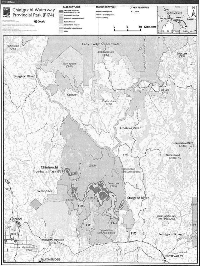
Enlarge figure 1: Regional setting (PDF)
Enlarge figure 2: Park boundary (PDF)
1.1 Objectives
Chiniguchi Waterway Provincial Park will be managed consistent with the four objectives for provincial parks:
Protection: To protect provincially significant elements of the natural and cultural landscapes of Ontario.
Recreation: To provide provincial park outdoor recreation opportunities ranging from highintensity day-use to low-intensity wilderness experiences.
Heritage Appreciation: To provide opportunities for exploration and appreciation of the outdoor natural and cultural heritage of Ontario.
Tourism: To provide Ontario’s residents and visitors with opportunities to discover and experience the distinctive regions of the Province.
2.0 Management context
Park management will follow direction from:
- Provincial Parks Act (1990) and regulation
- Ontario Provincial Parks Planning and Management Policies (OMNR 1992)
- Ontario’s Living Legacy Land Use Strategy (OMNR 1999) and policy clarifications (OMNR 2000), amendments, and related direction
- Crown Land Use Policy Atlas (OMNR 2004).
2.1 Environmental assessment
As a part of the Ontario Ministry of Natural Resources (MNR), Ontario Parks is a public sector agency which is subject to the Environmental Assessment Act. Park management will be carried out in accordance with legislation, policies, and guidelines that are required under A Class Environmental Assessment for Provincial Parks and Conservation Reserves (OMNR 2005a).
3.0 Park features and values
Chiniguchi Waterway Provincial Park is centred on traditional canoe routes that link to other areas of a larger cultural landscape north to Temagami and east to the Sturgeon River valley. The park contains backcountry campsites and other values in a rugged setting that has intact natural heritage features within close proximity to the City of Greater Sudbury.
3.1 Geological features
Chiniguchi Waterway Provincial Park lies within the Cobalt Plain physiographic region. The park is located in the Paleoproterozoic age Cobalt Embayment, which is part of the Southern Province of the Canadian Shield. The Cobalt Embayment contains Huronian Supergroup sedimentary rocks intruded by Nipissing Diabase gabbroic sills. Within the park, the Huronian Supergroup rocks belong to the Gowganda Formation. The differential erosion of the Gowganda Nipissing rock gives rise to locally rugged relief. The Gowganda Formation rocks and Nipissing Diabase are of regional significance (Blackburn 2004).
Quaternary deposits are predominantly of Pleistocene age. Ground moraine lies as a thin veneer with extensive bedrock outcrop in much of the main upland portion of the park. Thicker ground moraine deposits occur in the area between McCarthy Bay and Donald Lake. Remnants of glaciofluvial outwash are found in isolated pockets Maskinonge Lake (Blackburn 2004).
3.2 Biological features
Chiniguchi Waterway Provincial Park contains major representations of young to mature intolerant hardwood, pine, spruce, and modest to small representations of mature tolerant hardwoods within Ecodistrict 4E-4 (Morris 2002). The Wolf Lake area, the core area of which is currently designated as forest reserve and not included within the park, contains a large contiguous area of old growth red pine, which may be the largest remaining old growth red pine dominated forest in Ontario (OMNR 1999). Late winter moose habitat areas occur within the park.
There are five lake trout lakes within the Chiniguchi, waterway. The waterway and upland lakes were negatively affected by acid deposition from the Greater Sudbury area copper-nickel smelters in the early to mid-twentieth century. The pH levels of many of the lakes within this park have naturally been slowly rebounding from the effects of 100 years of acidification caused by airborne pollution from the Sudbury and area smelters.
The park performs an important hydrological function to the Chiniguchi waterway system (E. D. Morris, pers. com. 2006).
3.3 Cultural setting
An investigation into the cultural features specific to Chiniguchi Waterway Provincial Park has not been completed at this time. However, the area has a rich Aboriginal, logging, recreation and tourism history. Canoe routes in the area follow traditional Aboriginal travel ways as evidenced by local place names and pictographs within the park (Macdonald 1989, OMNR 1999). Traditional camping occurs along the waterway. The Matagamasi Lake dam was built around the turn of the 20th century to aid in river log driving (Bona 2002).
Any future planning will be within the context of a provincial framework, A Topical Organization of Ontario History (OMNR 1974). In addition, updates and discussions with First Nations and other agencies and stakeholders may be carried out to describe cultural heritage values and features within the park. This information may be used to develop management guidelines to conserve and protect representative archaeological and historical values and features, or to provide direction for further research.
3.4 Recreation
A variety of recreational uses occur within Chinigucbi Waterway Provincial Park. The park straddles a popular canoeing destination with portions of three documented traditional canoe routes that offer roadless remote camping. The Matagamasi - Sturgeon River Loop (125 kilometres),the Matagamasi Lake to Kukagami Lake route (37 kilometres) and the Chiniguchi Lake - Laura Creek Loop (57 kilometres) all have portions of their traditional routes within the park (Canadian Canoe Routes 2006). These routes are also considered part of the Wolf Lake and Laura Lake Routes and/or the Temagami to Lake Wanapitei Loop (Wilson 2004). There are several, unmanaged campsites and blueberry picking areas within the park that are associated with these canoe routes.
An abandoned mine, logging flumes, ridge hiking opportunities, and some of the oldest old growth red pine forests in Ontario, are among the features located within the park, on adjacent Crown land or within adjoining forest reserves (Green 199a).
At the south end of Silvester Lake there is an area waterfalls and pools that is referred to as the "Blue Lagoon". This area is a popular stop along the canoe route as well as with day users of the area (Green 1999).
In addition to canoeing and camping other "summer recreation activities include boating, fishing, hunting, wildlife/landscape/old growth viewing, and nature appreciation. During the winter months, snowmobiling, snowshoeing and cross-country skiing are popular activities (Kutas 2005; T. Lehman, pers. com. 2007).
4.0 Aboriginal uses
Chiniguchi Waterway Provincial Park is located within the Robinson - Huron Treaty (1850). The park is located approximately 25 kilometres east of Wahnapitae First Nation Reserve, the closest First Nation reserve to the park.
First Nations have expressed interest in and have shared knowledge of the park and surrounding area. Aboriginal communities have used the area for hunting, trapping, fishing, gathering and travel. These uses may continue, subject to public safety, conservation and other considerations.
Any communications and cooperation between Aboriginal communities and the MNR for planning and operations purposes will be done without prejudice to any future discussions or negotiations between the government of Ontario and Aboriginal communities.
5.0 Stewardship policies
The removal, damage or defacing of Crown properties, natural objects, relics, and artefacts is not permitted in provincial parks (Provincial Parks Act).
Non-native species will not be deliberately introduced into the park. Where non-native species are already established and threaten park values (i.e., has become invasive), a strategy to control the species may be developed (OMNR 1992).
5.1 Terrestrial ecosystems
5.1.1 Vegetation
Commercial forest operations are not permitted within the park (OMNR 1992).
The harvest of non-timber forest products such as club moss, Canada yew, etc., will not be permitted within the park (OMNR 1992). Wild rice harvesting operations will not be permitted.
There are no fuelwood cutting permits currently issued for the park. New permits will not be issued (OMNR 2000).
Insects and disease
Insects and diseases may be managed where the cultural, or natural values of the park are threatened (OMNR 1992). Control measures follow guidelines established by the Ontario Ministry of the Environment (MOE) and MNR. Whenever possible, biological control measures will be given preference over the use of chemicals (OMNR 1992).
Fire
Chiniguchi Waterway Provincial Park is located within the Great Lakes - St. Lawrence Zone for forest fire management. In accordance with provincial park policy and the Forest Fire Management Strategy for Ontario, forest fire will be carried out in the park as on surrounding lands (OMNR 2004b). Whenever feasible, MNR's Forest Fire Management program will use techniques that minimize damage to the landscape, such as limiting the use of heavy equipment or limiting the number of trees felled during response efforts (OMNR 2004b).
5.1.2 Wildlife management
Chiniguchi Waterway Provincial Park is located within Wildlife Management Unit 41. The removal or harassment of non-game animals is not permitted (Provincial Parks Act).
Hunting
Sport hunting is permitted to continue. Considerations of safety and conservation with respect to hunting may be made through future planning, which would include Aboriginal and public (OMNR 2000).
The Fish and Wildlife Conservation Act (1997) and the Migratory Birds Convention Act (1994) govern hunting within the park. The Ontario Hunting Regulations Summary contains regulations specific to this area. The harvest of bullfrogs or snapping turtles is illegal in provincial parks.
Bear management areas
Chiniguchi Waterway Provincial Park includes portions of six allocated bear management areas (BMA): SU-41-008, SU-41-014, SU-41-020, SU-41-021, SU-41-015, and NB-41-022 (Figure 3).
Existing commercial bear hunting operations are permitted to continue. This may be subject to conditions identified during future planning which will involve Aboriginal dialogue public consultation (e.g., the designation of nature reserve zones). New BMA licences will not be permitted (OMNR 2000; 2003).
Figure 3: Bear Management Area
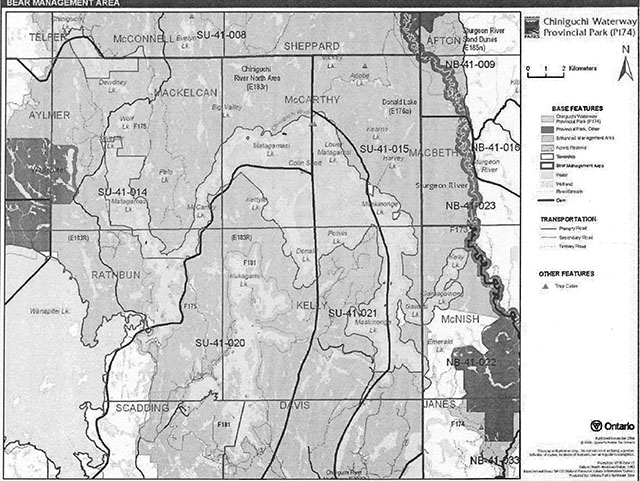
Enlarge figure 3: Bear Management Area (PDF)
Trapping
There are portions of nine active trap lines within the boundary of this park: SU-27, SU-39, SU-40, SU-47, SU-48, and SU-49. The eastern-most area of the park includes a portion of an unallocated trapline area. There are two trap cabins located within the park (Figure 4).
Existing commercial fur harvesting operations may continue where the activity has been licensed or permitted since January 1, 1992, except in wilderness and nature reserve zones which may be determined through future planning. New operations, including trap cabins and trails, will not be permitted (OMNR 2000; 2003). Transfers of active trap line licenses are permitted, subject to a review of potential impacts and the normal transfer or renewal conditions that apply 1asdf1 Transfers include situations where a is surrendered with a request that it be reissued to another individual or organization that an existing operation. Trap cabins are considered part of a trapline and would be transferred with the trapline for the purposes of trapping. If a trapline license is revoked or surrendered, all portions of the registered line within the park will be rescinded from the legal description of the trap line (OMNR 2003).asdf. The eastern section of the park, in McNish Township, will remain unallocated and will be excluded from any future trapline license allocations.
Figure 4: Trapline area
Enlarge figure 4: Trapline area (PDF)
5.1.3 Industrial resources
There are no aggregate pits located within the park. Aggregate extraction is not permitted in provincial parks unless it is allowed by regulation (Provincial Parks Act).
Mineral exploration and mining are not permitted within the park. The mining and surface rights on all lands within the park have been withdrawn from staking under the Mining Act (1990). In accordance with Ontario’s Living Legacy Land Use Strategy, however, access through the park to mining lands (i.e. forest reserve(s) and mining patents) will be permitted for purposes of mineral exploration, development, or operations. Access will be planned in accordance with the requirements of the Environmental Assessment Act.
5.1.4 Access and crossings
Access
Chiniguchi Waterway Provincial Park is accessible via road, water and air.
The western portion of the park is accessed via MacKelcan Road, which originates from Highway 17 where it is known as Kukagami Road. The eastern portion of the park and Chiniguchi Forest Reserve, near Maskinonge Lake, can be accessed via Davis Road North.
Access to the park occurs by water from the north along the Chiniguchi River, from the south end of Matagamasi Lake and also from the east from the Sturgeon River. A parcel of Crown land within the Wolf Lake Old Growth Forest, Forest Reserve (F17S) south the park on Matagamasi Lake has been used as an informal drive-to access. Individuals using the access leave vehicles along the side of the road. The number of vehicles along this road has been increasing in recent years, and has at times caused congestion for local residents and visitors, especially during peak summer months. Other access occurs from the intersection of the portage between Lake Wanapitei and the MacKelcan Road on the side of the Wolf Lake Old Growth Forest, Forest Reserve (F17S). There are no parking facilities at this location either; however individuals park along the road. An evaluation of access, including current use patterns, existing and potential alternative access and parking locations may be explored through future planning.
The interior of the park is accessible by canoe and aircraft landings on larger lakes - Wolf, Matagamasi, Lower Matagamasi, Donald, and Maskinonge lakes.
Roads
The park is accessible via Kukagami Lake Road from Highway 17 from the south. The Kukagami Lake Road becomes the MacKelcan Road south of Lake Wanapitei. In the Matagamasi Lake area it is also known locally as Bushy Bay Road. The MacKelcan Road was built to access Crown timber allocations north of the Wolf Lake area. The MacKelcan Road passes through the Wolf Lake Old Growth Forest, Forest Reserve and then Chiniguchi Waterway Provincial Park west of Silvester Lake. Although the MacKelcan Road was intended to be a primary forest access road, it was abandoned as such due to difficult terrain and alternate access was developed east and north of Wolf Lake. The portion of MacKelcan Road located within Wolf Lake Old Growth Forest, Forest Reserve and within the boundary of the Chiniguchi Waterway Provincial Park and beyond will be left to naturally deteriorate. There will be no maintenance of this road through the forest reserve and park.
The Ontario Federation of Snowmobile Clubs (OFSC) Trans Ontario Provincial Series (TOPS) connector trail C206D uses a portion of the abandoned MacKelcan Road through the forest reserve and park to serve as a recreational trail to access areas north to Temagami. The crossing of Chiniguchi River within the Wolf Lake Old Growth Forest, Forest Reserve will remain and will be managed through a Memorandum of Understanding as part of the OFSC C260D trail.
The south end of Maskinonge Lake is accessible via Davis Road North, which runs through Davis and Kelly Townships. This road provides access to the dam and a block of private land located at the southern end of Maskinonge Lake. This does not enter the park boundary, but does travel very close to the boundary of Chiniguchi Forest Reserve (F174) just north of the parcel of private land.
People use another road, the Matagamasi Lake Road to get to an informal access point on the south end of Matagamasi Lake. Although this road is outside the park, it provides access to the south end of Matagamasi Lake and from there water access to that portion of the park which is on the north end of Matagamasi Lake.
There is a network of existing roads and trails that may be used by snowmobiles and/or ATV users. The full extent to which some of these roads and trails bisect park boundaries, and how heavily they are used, is not well known.
Where existing forest and/or tertiary access roads are essential for continued access beyond the park for forest management, access to in-holdings (e.g., patent land, land use permits, etc.), or recreation purposes, and alternative road access does not exist, or road relocation is not feasible, existing roads will continue to be available for access. Continued use will include maintenance and may upgrades (OMNR 2004a). Ontario Parks is not responsible for the maintenance or upgrade of any roads within the park boundary.
Any proposed development or maintenance/upgrading of existing roads must meet all Environmental Assessment Act requirements.
Railway
There are no crossings of the park boundary by railway corridors.
Utility corridors
There are no utility corridors, which cross the boundary of this park.
All public utilities (e.g., gas pipelines, transmission lines, communications towers) must park lands wherever possible. New utility corridor crossings may be necessary to maintain essential public services (OMNR 2004a).
Any future utility corridors proposed through the park, where park lands are unavoidable, will be reviewed on a case-by-case basis. Protection of park features and values will be priority and all requirements of the Environmental Assessment Act will be met.
Recreational trails
Canoe Routes: There are portions of three traditional canoe routes that provide roadless remote camping opportunities in Chiniguchi Waterway Provincial Park. These canoe routes can be accessed from the south end of Matagamasi Lake.
The Matagamasi - Sturgeon River Loop is approximately 125 kilometres while the Chiniguchi Lake - Laura Creek Loop is 57 kilometres. Both routes are recommended for novice to intermediate paddlers. The Matagamasi Lake to Kukagami Lake route is approximately 37 kilometres long and is recommended for novice paddlers (Canadian Canoe Routes 2006). There are several options within these routes that could incorporate more lakes and extend these routes to access more of the area surrounding the park. These routes are also considered part of the Wolf Lake and Laura Lake Routes and/or the Temagami to Lake Wanapitei Loop (Wilson 2004). There are several unmanaged backcountry campsites, located within the park, which are associated with these canoe routes.
Hiking Trails: There are no designated hiking trails within in Chiniguchi Waterway Provincial Park. New hiking trails may be developed if the need arises. Any proposed development within the park is subject to Environmental Assessment Act requirements.
ATV Trails: There are no authorized ATV trails within the park; however, there may be some existing unauthorized ATV use on forest and tertiary access roads within the park. Existing use of these roads to access LUPs and cottages is permitted continue unless this use threatens park values. ATV use may be authorized on old forest access and tertiary roads; this use will be reviewed during future planning with full Aboriginal dialogue and public consultation. Off-trail ATV use is not permitted (OMNR 2000).
Snowmobile Trails: Ontario Federation of Snowmobile Clubs (OFSC) Trans Ontario Provincial Series (TOPS) connector trail C206D crosses through the park in MacKelcan Township west of Silvester Lake. The trail follows the MacKelcan Road and is maintained by the Sudbury Trail Plan Association. There may also be some unauthorized snowmobile use along existing tertiary access roads. Snowmobile use on existing routes for access to private cottages, LUPs and for recreational ice fishing may continue unless park values are threatened. Snowmobile use may be authorized on old forest access and tertiary roads. Off-trail snowmobile use is not permitted. New snowmobile trails may be considered though future planning with full Aboriginal dialogue and public consultation (OMNR 2000).
5.1.5 Adjacent land management
The majority of the park is surrounded by enhanced management areas; some forest reserves are adjacent to the park and a portion abuts a general use area and Sturgeon River Provincial Park.
Forestry
The land adjacent to the park is located within the Sudbury Forest Management Unit (#889) and the Nipissing Forest Management Unit (#754) 2007). The Sudbury Forest is currently managed by a sustainable forest licence company. The Nipissing Forest is currently managed by Nipissing Forest Resources Management Incorporated.
Provincial parks
Wanapitei Provincial Park (P2021): This 3,413 hectare natural environment park is located approximately 35 kilometres northeast of Sudbury on the northern shore of Wanapitei Lake.
This stretch of shoreline on Wanapitei Lake contains sandy shore bluffs and a gently rolling outwash plain with rockland outcrops, and small stream valleys leading to the lake. The park represents a variety of site conditions, forest types, and minor vegetation communities. This is a non-operating park with no visitor facilities. Swimming, unmanaged car camping, hiking, fishing, and wildlife viewing are some of the activities that take place within the park. This park was regulated under the Provincial Parks Act in 1985.
Sturgeon River Provincial Park: This waterway class park encompasses 7,985 hectares and follows remnants of a larger glacial river with multiple terraces. This park was recently enlarged to include the floodwood forest natural heritage area with flat lacustrine deposits and rock outcrops which is forested in spruce and poplar with pine, and red oak on dryer sites. Gently rolling ground moraine deposits support Jack pine. Red pine stands can be found within the site intermixed with treed wetlands on moderately rolling hills. The park follows an existing canoe route, part of which connects to Chiniguchi Waterway Provincial Park via the Ozhway Lake chain through Gawasi Lake, Gamagowong Lake, and Kelly Lake.
Forest reserves
Forest reserves are areas of natural heritage and special landscapes which overlap with pre existing mining lands, primarily claims and leases. These areas were placed under interim protection in order to remove lands from commercial forest operations, while still allowing for mineral exploration of pre-existing mining claims and leases. Policies for forest reserves are similar to the policies for new conservation reserves, except that mining and related activities are permitted in a forest reserve. Commercial forest harvest, new hydroelectric power development, and peat extraction will not be permitted, but most other resource and recreation uses will be permitted, provided they are consistent with the features and values being protected (OMNR 1999).
The original intent for these forest reserves was to regulate them as part of the adjacent provincial parks or conservation reserves once the claims or leases had retired through normal processes. In an effort to achieve a degree of certainty regarding the regulation timelines of protected areas and future mineral exploration and development, a local land use planning process called 'disentanglement' was initiated in 2005 to consider proposals to reduce the number of forest reserves. The Ontario Prospectors Association (OPA) and the Partnership for Public Lands (PPL), with the assistance of MNR, developed recommendations to provide initial direction for the redesignation of forest reserves. The OPA and PPL recommended that some forest reserves be removed and the area redesignated. Some forest reserves were to be removed but replacement areas were to be sought, and some areas were to remain status quo, which meant that as the mining tenure lapsed through normal processes those portions would be regulated as part the adjoining protected area (OMNR 2005c). The forest reserves associated with Chiniguchi Waterway Provincial Park are part of this process.
Kukagami Lake Forest Reserve (F181): This forest reserve includes Kukgami Lake, a recovering lake trout lake, and a natural heritage area of jack pine stands of all age classes on mildly rolling sand and gravel deposits, located to the southwest of Kukagami Lake.
The original land use intent was to regulate this forest reserve as a part of Chiniguchi Waterway Provincial Park once mining tenure (claims and leases) had lapsed through normal processes. The recommendation for this forest reserve was that it would remain "status quo", and as mining tenure lapsed through normal processes, the area would be added to the park. However, during the boundary refinement process for Chiniguchi Waterway Provincial Park in 2005, when portions of Kukagami Lake Forest Reserve were to have been included within the park, concerns from the local campers association were brought to the MNR. After multiple meetings and discussions, it was decided that the new land use designation of "conservation reserve" would be proposed for this forest reserve. A land use amendment to Land Use Strategy is required with full Aboriginal dialogue and public consultation before a final decision on the designation of this area is made.
Chiniguchi Forest Reserve (F174): This forest reserve is located at the south end of Maskinonge Lake. This forest reserve was originally identified by the Land Use Strategy for inclusion in the recommended Chiniguchi Waterway Provincial Park. The intent for this area was that as mining tenure lapsed through normal processes, that area would be regulated as part of Chiniguchi Waterway Provincial Park. This intent has remained the same throughout the disentanglement process.
Wolf Lake Old Growth Forest, Forest Reserve (F175): This forest reserve includes Wolf Lake portions of Matagamasi and Silvester lakes and all of Dewdney Lake as well as the land surrounding these lakes. This forest reserve contains portions of the largest contiguous area of red pine stands in Ecoregion 4E which are older than 140 years. This area may be the largest remaining contiguous old growth red pine-dominated forest in Ontario. Wolf Lake has high recreational value, being situated on the Chiniguchi River and traditional canoe routes. Many of the lakes within with the forest reserve are lake trout lakes.
The original land use intent for this area was to regulate this forest reserve as part of Chiniguchi Waterway Provincial Park once mining tenure (claims and leases) had lapsed through normal processes. Portions of this site, where claims/leases had lapsed, were regulated as part of Chiniguchi Waterway Provincial Park in 2006. Due to the uncertainty of associated with disentanglement process only large, connected sections of the site were brought forward for regulation. The remaining portions of the forest reserve are still part of the ongoing disentanglement discussions, but continue to remain withdrawn from staking and are under interim protection (e.g., no forest allocations). The recommendation for this forest reserve was that the forest reserve designation be removed, and the area be re-designated as an enhanced management area, consistent with the old growth forest values it could be a new enhanced management area conserving the natural heritage features of old growth red pine (e.g., E174n). In that re-designation scenario replacement protected area would be identified and brought forward for regulation as a protected area to offset the lands removed from the forest reserve.
This would include a proposed land use amendment to the Land Use Strategy with full Aboriginal dialogue and public consultation to review removal and replacement lands.
Much of the disentanglement discussion has focused on the northern claims and leases surrounding the Wolf Lake area. Future discussions with local stakeholders, industry and the general public may allow for alternate proposals (from the remove and replace designation) for this particular area. Alternate proposals may also explore the possibility of regulating the southern portion of Wolf Lake Old Growth Forest - Forest Reserve, surrounding the southern portions of Matagamasi as conservation reserve. A land use amendment to the Land Use Strategy is required with full Aboriginal dialogue and public consultation before re-designation can occur.
Enhanced areas
Enhanced management areas (EMA) have been designated adjacent to this waterway park to retain the general Crown land use for forestry and mining while maintaining existing remote access and recreational canoe route uses.
EMAs are a land use category established through the Land Use Strategy to provide more detailed land use direction in areas of special features or values (OMNR 1999). There are two enhanced management areas located adjacent to Chiniguchi Waterway Provincial Park.
Chiniguchi River North Area Enhanced Management Area (E183r): This recreation class EMA is an important area for recreation, tourism, and the resource sector including forestry and mining. The area contains a series of interconnecting lakes and rugged scenic topography, portions of traditional canoe routes. Recreational activities in the area include canoeing, fishing, hunting, snowmobiling and cross country skiing. Pockets of remote roadless landscape exist within this EMA, which are well used by a number of tourism establishments.
The area contains active forest operations and a considerable amount of mining exploration. Land use direction and resource management activity will be compatible with protecting the natural and recreational values of the area. Further planning will identify individual management strategies and zones to manage and protect recreation, remote access and resource sector interests while providing for traditional uses (OMNR 2004a).
Donald Lake Enhanced Management Area (E176a): This remote access EMA is a high quality wilderness recreational area with rugged scenic topography and limited access. The EMA is well used by a number of tourism establishments. Mining and forest resources are also important values. Typically, these are relatively large areas which provide the public and tourism operators with high quality remote recreational experiences including hunting, fishing, canoeing, and camping. Given the large size, remoteness, and relative absence of roads, this EMA will play a significant role in protecting wilderness values outside the protected areas system. The land use intent is to maintain the remote character and backcountry recreational values. New road access will be restricted through the use of appropriate management techniques, such as winter logging.
5.1.6 Land disposition
Chiniguchi Waterway Provincial Park surrounds Matagamasi, Donald, and Maskinonge lakes as well as many smaller lakes. The park includes the land and water located within McConnell, MacKelcan, Rathbun, McCarthy, Kelly and McNish townships (Figure 2).
New land disposition for the private use of individuals or corporations will not be permitted in the park (OMNR 1992; 2000).
Figure 2: Park boundary

Enlarge figure 2: Park boundary
Land use licenses of and unauthorized
There are six land use permits (LUPs) within the boundary of Chiniguchi Waterway Provincial Park. Three of these permits are issued for private recreation camps in McCarthy Township and three are issued for private recreation camps in Kelly Township.
Existing authorized LUPs may be eligible for enhanced tenure but not the purchase of land. Recreational camp LUPs cannot be changed to commercial LUPs unless this is supported during future planning. Enhanced tenure is defined as a possible extension of the term of the LUP for up to 10 years or upgrade in tenure (i.e., LUP to lease) (OMNR 2000a).
Enhanced tenure for an LUP is not guaranteed. Requests for enhanced tenure or to transfer LUPs will be reviewed based upon the following criteria:
- Continued compliance with the conditions of the LUPs
- Current land disposition policies for LUPs
- Consistency with park objectives to sustain values - no effects on heritage values and/or conflict with other uses
- Consistency with Aboriginal land claim negotiations or protocol agreements
- All rents, taxes, fees, rates, or charges are paid and in good standing.
An extension in the term of tenure for an existing LUP does not convey a commitment to provide for a change in the type or the standard of existing access to the private recreation camp.
There is one commercial outpost LUP at the south end of Maskinonge Lake. This LUP is located in close proximity to Chiniguchi Waterway Provincial Park, but found within the boundary of Chiniguchi Forest Reserve (F174). The forest reserve will remain as such until the claims lapse through normal processes when these lands will become part of the park.
There are no known licenses of occupation within the boundary of this park.
There are two areas within the park that have been used in the past to store ice fishing huts during the off season months. The storage of these huts is considered to be an unauthorized occupation and will be evaluated. Direction will be developed to manage this unauthorized use. There are no other known unauthorized occupations.
Patent land
There are seven parcels of private land (in-holdings) that are surrounded by Chiniguchi Waterway Provincial Park. Private land is not included within the park boundary and, as such, park policy does not apply.
Boat caches
There are no known authorized boat caches located within the boundary of Chiniguchi Waterway Provincial Park. Boats are not permitted to be left unattended in the park without written permission from the superintendent under the authority of the Provincial Parks Act.
5.2 Aquatic ecosystems
Sustaining quality water resources is integral to the protection of park and adjacent lands. The MOE enforces applicable legislation and regulations for water quality.
5.2.1 Water management
There is one water control structure located within the park boundary. This MNR dam, which was replaced in 2004/2005, is located at the north end of Matagamasi Lake. The dam is a spillway control and does not produce hydro-electric power.
The removal of existing water control structures and/or replacement of existing structures may be considered through future planning. New commercial hydroelectric developments will not be permitted (OMNR 2000).
5.2.2 Fisheries management
The majority of the larger lakes in Chiniguchi Waterway Provincial Park were once high quality lake trout lakes. Unfortunately, these lakes were severely impacted by acidification related to industrial smelter emissions from the Sudbury area. In 2000, and Laurentian University and partners launched the Northeastern Lake Trout Enhancement Project- a five year project designed to assess, restore, and protect lake trout populations in Northeastern Ontario. Even with early signs of recovery from acidification, over-exploitation and the impact of introduced species are other significant issues facing the fisheries. Fishing pressure and angler distribution patterns have been monitored throughout the region, including the lakes in Chiniguchi Waterway Provincial Park. The overall health and future of the Northeastern lake trout resource is ongoing, along with potential management actions to ensure long-term resource sustainability (W. Selinger, pers. com. 2004).
Within Chiniguchi Waterway Provincial Park the water quality of Maskinonge has improved to the point where the lake trout population has recovered and is maintaining a self-sustaining population. The water quality of Matagamasi, Lower Matagamasi, Donald, and Colin Scott lakes is improving and lake trout restoration is underway. Lake trout restocking is ongoing in these lakes. Silvester, and Potvin lakes are still too acidic for lake trout (W. Selinger, pers. com. 2004).
In addition to lake trout, fish species that may be found in some of the lakes of Chiniguchi Waterway Provincial Park also include northern muskellunge, smallmouth bass, yellow perch, walleye, rock bass, white sucker, lake herring, lake whitefish, brown bullhead, burbot, pearl dace, pumpkinseed, lake chub, common shiner, and Iowa darter(W. Selinger, pers. com. 2004).
Fisheries management will complement the maintenance and enhancement of native, self-sustaining fish populations (OMNR 1992).
Sport fishing
Sport fishing is permitted within the park. This activity is governed by legislation and regulations in the Fish and Wildlife Conservation Act (1997) and the Fisheries Act (1985). The Recreational Fishing Regulations Summary contains details on the applicable regulations for this area,
Commercial baitfish
The following townships maintain baitfish harvest licence areas including: McConnell (SU0034), MacKelcan (SU0050), Rathbun (SU0068), McCarthy (SU0049), Kelly (SU0067) and McNish (NB1001) as per Figure 5.
Existing commercial baitfish harvesting may continue where the activity has been licensed or permitted since January 1, 1992. This activity may be subject to conditions identified through future planning (e.g., the designation of nature reserve zones) or fisheries management plans. New baitfish licenses will not be permitted(OMNR 2000; 2003).
Fish stocking
The stocking of native lake trout species in previously stocked lakes, such as Matagamasi, Lower Matagamasi, Donald, and Colin Scott lakes will be permitted to continue, as funding permits, until there is sufficient natural recruitment to maintain self-sustaining lake trout populations. Stocking of native lake trout species may also be considered in Dewdney, Silvester, and Potvin lakes should acid levels fall to make such intervention feasible. Other native fish species may be considered through future planning, with full Aboriginal dialogue and public consultation. Non-native fish species will not be deliberately introduced into park waters (OMNR 1992).
6.0 Operations policies
6.1 Recreation management
Future planning, with full Aboriginal dialogue and public consultation, will review direction on motorized and non-motorized recreation uses.
6.1.1 Motorized recreation
Motorboats
The use of motorboats is permitted to continue, unless park values are threatened (OMNR 2004a). Long term management direction for motorboat use will be determined through future planning, which will include full Aboriginal dialogue and public consultation (OMNR 2004).
Aircraft
Aircraft landings are permitted in this waterway park. All aircraft landings are subject to regulation and valid aircraft landing permits issued by the park superintendent under the authority of the Provincial Parks Act. Long-term direction for aircraft landings will be determined through future planning (OMNR 1992).
Snowmobiles
One existing OFSC snowmobile trail, C206D is within the park. Snowmobile use on established routes for access to private cottages, LUPs, and recreational ice fishing may continue unless park values are threatened. Snowmobile use may be authorized on old forest access and tertiary roads. Off-trail snowmobile use is not permitted in the park. New trails may be considered during future planning, which will include full Aboriginal dialogue and public consultation (OMNR 2000).
All-terrain vehicles
There are no authorized ATV trails within the park. Unauthorized ATV trails that are documented may be permitted to continue until they are reviewed during future planning, with full Aboriginal dialogue and public consultation. The park superintendent may discontinue existing unauthorized trails if it is determined that such trails threaten park features and values, create user conflicts or raise safety and/or liability issues. Existing use of forest and tertiary access roads to access private in-holdings and LUPs is permitted to continue unless this use threatens park values. ATV use may be permitted on old forest access and tertiary roads. Off-road or off-trail use of ATVs will not be permitted. Proposals for new trails may only be considered during future planning with Aboriginal dialogue and public consultation (OMNR 2000).
Figure 5: Baitfish harvest area
Enlarge figure 5: Baitfish harvest area (PDF)
6.1.2 Non-motorized recreation
Camping
There are no managed campsites within Chiniguchi Waterway Provincial Park; however, there are over 20 unmanaged backcountry campsites along the canoe route. These are used by visitors who are looking for dispersed remote and roadless canoe-in and boat-in camping. No car camping access or campground will be provided within Chiniguchi Waterway Provincial Park.
Ontario Parks may assess the condition of existing backcountry campsites and may maintain, rehabilitate, or close sites as required. If there is an identified need, new backcountry campsites may be considered (OMNR 2004a). Long-term management direction for backcountry camping may be determined through future planning, with full Aboriginal dialogue and public consultation. Infrastructure will be permitted in order to protect park features and values in response to use, environmental deterioration and environmental protection requirements. Any proposed development in the park must fulfill the requirements of the Environmental Assessment Act.
Hiking
There are no authorized hiking trails within the boundaries of this park.
Unauthorized hiking trails and other non-mechanized trails that are documented may be permitted to continue until they are reviewed in future planning, with full Aboriginal dialogue and public consultation. The park superintendent may discontinue existing unauthorized trails if it is determined that such trails threaten park features and values, create user conflicts or raise safety and/or liability issues.
If there is an identified need, the development of new hiking trails may be considered through future planning which will include full Aboriginal dialogue and public consultation. Trail infrastructure to protect park values and features will be permitted. Any proposed development within the park is subject to Environmental Assessment Act requirements.
Canoeing/kayaking
Existing uses may continue, unless park values are threatened (OMNR 2004a). Infrastructure to protect park features and values may be permitted and developed in response to use, environmental deterioration and environmental protection requirements.
6.1.3 Emerging recreation uses
There are emerging recreational uses for which there is limited or no policy to deal with their management (e.g., adventure racing, geocaching). The park superintendent will use legislation, policy, and guidelines which are in place to manage emerging uses.
6.0 Development
There is no existing park infrastructure located within the boundary of Chiniguchi Waterway Provincial Park. Infrastructure to protect park features and values may be permitted and developed in response to use, environmental deterioration, and environmental protection requirements. Any proposed development within the park will be subject to future planning and the requirements of the Environmental Assessment Act.
6.2 Commercial tourism
There are no existing tourism facilities within the park, however there are tourism establishments/outpost camps located on private land surrounded by the park and within the boundary of Chiniguchi Forest Reserve (F174) and on adjacent lakes (e.g., Lake Wanapitei, Kukagami Lake).
New commercial tourism facilities may be considered where they be consistent with park policy (OMNR 2004a). Any development must meet the requirements of the Environmental Assessment Act. Existing authorized tourism facilities may continue subject to management prescriptions determined through future planning. Existing tourism facilities (e.g., LUPs, leases) may be eligible for enhanced tenure, and decisions will be made in future planning.
7.0 Cultural resources
An assessment of the cultural resources specific to the park has not yet been completed. The management of any cultural values within this park will be directed toward protection and heritage appreciation (OMNR 1992).
8.0 Heritage education
Literature and other supporting information may be developed to describe the park in the context of Ontario’s provincial park system. Boundary limits, significant heritage features and permitted uses of the may be included in park literature.
Prospective park visitors may be informed about the sensitivity and significance of park values through park literature.
9.0 Research
Scientific research by qualified individuals which contributes to the knowledge of natural or cultural history, or to environmental or recreational management, may be encouraged in the park. Ontario Parks will encourage institutions, such as universities, to undertake research projects.
All research programs will require the approval of Ontario Parks and are subject to park policy and other applicable legislation. Any materials removed from the park will remain the property of Ontario Parks.
Approved research activities and facilities will be compatible with the park’s protection objective. Any site which is affected by research will be rehabilitated as closely as possible to its original state. Environmental Assessment Act requirements will apply.
References
Blackburn, C. E., 2004. Earth Science Inventory Checklist Chiniguchi P174. Prepared by
Blackburn Geological Services for the Ontario Ministry of Natural Resources.
Bona, L.D. 2002. Stage I and /I Archaeological Assessment, Matagamasi Lake Dam. Ontario Ministry of Natural Resources.
Canadian Canoe Routes. 2006. Accessed December 13, 2006.
http://www.myccr.com/canoedb/routeDetails.php?routeid=346
http://www.myccr.com/canoedb/routeDetails.php?routeid=386
http://www.myccr.com/canoedb/routeDetails.php?routeid=512
Environmental Assessment Act, 1990.
Fisheries Act, 1985.
Fish and Wildlife Conservation Act, 1997.
Green, M. C., 1999. Outdoor School III Canoe Trip leader’s Guidebook: Chiniguchi Lake – Laura Creek loop. Laurentian University - Outdoor Adventure leadership Program.
Kutas, B., 2005. Draft Recreation Assessment Chiniguchi Waterway Provincial Park (P174) and Forest Reserves (F175 and F181) Recreation Inventory Report Version 1.1. Prepared for Ontario Ministry of Natural Resources, Ontario Parks.
Lehman, T., 2007. Personal Communication. Ontario Ministry of Natural Resources Sudbury District Forester. January 23, 2007.
Mining Act, 1990.
Migratory Birds Convention Act, 1994
Macdonald, C. 1989. A Historical Map of Temagami and Area.
Morris, E.D., 2002. Natural Heritage Area - Life Science Checksheet Chiniguchi Waterway Provincial Park (OLL P174). Ontario Ministry of Natural Resources.
Morris, E. D., 2006. Personal Communication. Ontario Parks Northeast Zone Ecologist, Ontario Ministry of Natural Resources. December 13, 2006.
Ontario Ministry of Natural Resources (OMNR). 1974. A. Topical Organization of Ontario History. Historic Sites Branch Division of Parks.
Ontario Ministry of Natural Resources (OMNR). 1992. Ontario Provincial Parks Planning and Management Policies, 1992 Update.
Ontario Ministry of Natural Resources (OMNR). 1999. Ontario’s Living Legacy Land Use Strategy.
Ontario Ministry of Natural Resources (OMNR). 2000. Ontario’s Living Legacy Land Use Strategy (Policy Clarification).
Ontario Ministry of Natural Resources (OMNR). 2001. Trapping in new OLL Parks.
Ontario Ministry of Natural Resources (OMNR). 2003. Directions for Commercial Resource Use Activities in Provincial Parks and Conservation Reserves. 5 pp.
Ontario Ministry of Natural Resources (OMNR). 2004a. Crown Land Use Policy Atlas.
Ontario Ministry of Natural Resources (OMNR). 2004b. Forest Fire Management Strategy for Ontario.
Ontario Ministry of Natural Resources (OMNR). 2005a. A Class Environmental Assessment for Provincial Parks and Conservation Reserves.
Ontario Ministry of Natural Resources,2005b. Public and Aboriginal Consultation Documentation Form Ontario’s Living Legacy Protected Area Boundary Refinement Review - Chiniguchi Waterway Provincial Park (P174).
Ontario Ministry of Natural Resources,2005c. Summary of Proposed "Disentanglement" Strategies for Recommended Protected Areas and Pre-existing Mining Lands.
Ontario Ministry of Natural Resources, 2007. List of Forest Management Units (MU) in Ontario (200612007) (designated under the Crown Forest Sustainability Act, Section 7) All Management Units effective as of April 1, 2006. Accessed January 22, 2007
Provincial Parks Act, 1990.
Selinger,W. 2004. Personal communication. Project Manager - Northeastern Lake Trout Enhancement Project, Espanola, Ontario Ministry of Natural Resources.
Wilson, H., 2004. Canoeing, Kayaking and Hiking in Temagami. Boston Mills Press, Erin, Ontario.
Appendix A: Background information
- Name: Chiniguchi Waterway Provincial Park (P174)
- Classification: Waterway
- Ecoregion/Ecodistrict: 4E-4
- OMNR Administrative Region/District: Northeast - Sudbury, North Bay
- Total Area (ha): 9,368
- Regulation date & Number: June 2006 (O. Reg. 331/06)
Representation
Earth science:
Chiniguchi Waterway Provincial Park lies within the Cobalt Plain physiographic region. The park is located in the Paleoproterozoic age Cobalt Embayment, which is part of the Southern Province of the Canadian Shield. The Cobalt Embayment contains Huronian Supergroup sedimentary rocks intruded by Nipissing Diabase gabbroic sills. Within the park, Huronian Supergroup rocks belong to the Gowganda Formation. Nipissing Diabase sills and dikes are emplaced into the Cobalt Group rocks throughout this area.
Gowganda Formation consists of distinct, diverse sequences of clast- and matrix-supported conglomerate, pebbly wacke, siltstone, mudstone and arenite. Interpreting the origin of deposition of the Gowganda Formation is controversial. The occurrence of till-like conglomerate, drop stones in wacke and siltstone, varved wacke and siltstone, striated clasts, and possibly a striated pavement occurring beneath the formation all point to a glacial, glacial-marine or glaciolacustrine origin of the formation. A debris-flow origin for the conglomerates and a deposition from turbidity currents for the finely laminated sediments have also been proposed. A combination of debris flow or turbidity current and a glacial origin represents an alternative hypothesis. Rocks of the formation were observed at two stations during the present inventory. On McCarthy Bay in Mackelcan Township, thinly bedded siltstone to arenite dips at a shallow angle (20 to 30°) to the northeast. This shallow dip is consistent with previous observations in this general area throughout the Cobalt Embayment. By contrast, on Maskinonge Lake in Kelly Township, Gowganda rocks are conglomeratic. Cobble- to boulder-sized clasts are set in a much finer matrix, ranging from silt to sand. These clasts constitute <20% of the rock, and rarely touch each other: hence the conglomerate is matrix-supported. Composition of the cobbles and boulders is representative of the erosional hinterland from which they were derived, which would have been predominantly an igneous terrain of Archean age: they vary from volcanic to plutonic, but are mostly granitic. The suspension of large clasts in a finer matrix, as seen here, is suggestive of either a glacial, till-like origin, or debris flow deposits (Blackburn 2004).
Quaternary deposits are predominantly of Pleistocene age. Ground moraine has been interpreted to lie as a thin veneer over bedrock in much of the main upland portion, with thicker deposits of ground moraine in the area between McCarthy Bay and Donald Lake. Remnants of glaciofluvial outwash similarly interpreted in isolated pockets around Maskinonge Lake were confirmed in the present inventory by observation of fine-bedded sands in low bluffs at the north end of the lake (Blackburn 2004).
Good examples of Gowganda Formation rocks are to be seen in shoreline outcrops in Chiniguchi Park. They offer opportunity for viewing an ancient rock sequence about which there is much controversy concerning the environment of deposition of its conglomeratic portion (i.e. debris flow, turbidity current or glacial till environment). Huronian Supergroup rocks are the prominent bedrock components of two major parks in the system, Lady Evelyn-Smoothwater and Killarney, both of which display Gowganda Formation, probably to provincial Significance. The present park supplements them on a regional basis, so that Gowganda Formation is here given regional significance (Blackburn 2004).
Nipissing Diabase, although well represented in the present park, is similarly present in Lady Evelyn-Smoothwater and Killarney parks, where it is probably present on a provincially significant basis. It is here given regional significance (Blackburn 2004).
Life science:
Forests of Chiniguchi Waterway Provincial Park consist of white and red pine, intolerant hardwoods, spruce, and tolerant hardwoods (Morris 2002). The Wolf Lake area contains the largest contiguous area of old growth red pine dominated stands in Ontario (OMNR 1999).
The waterway and upland lakes were adversely affected by acid deposition from local copper nickel smelters. The pH levels of many of the lakes included within this park have been slowly rebounding from the effects of copper/nickel smelting. At the beginning of the 1980s, pH of many of the lakes in the area was less than 5 (Morris 2002). While lake pH in the Chiniguchi River lake chain has essentially recovered (pH 6.0-6.5), the recovery rate of the upland lakes has been slower (pH 5.3). There are five lake trout lakes within the Chiniguchi waterway (Morris 2002). Significant biological improvements can be expected as pH levels rise above the threshold of pH 5.0 (Morris 2002).
The park performs an important hydrological function to the Chiniguchi waterway system.
Cultural resources:
An investigation and analysis of the cultural resources specific to the entire Chiniguchi Waterway Provincial Park has not been completed at this time. However, the area has a rich Aboriginal, logging, recreation and tourism history. Canoe routes in the area follow traditional Aboriginal travelways and pictographs are located within the park (OMNR 1999). The Matagamasi Lake dam was built around the beginning of the 20th century to aid in river drive logging (Bona 2002).
Recreation:
A draft inventory of the recreational features and activities (existing and/or potential) has been completed for Chiniguchi Waterway Provincial Park (P174) and associated forest reserves including Wolf Lake Old Growth Forest Reserve (F175) and Kukagami Lake Forest Reserve (F181) (Kutas 2005).
Chiniguchi Waterway Provincial Park is a popular canoeing destination and contains numerous lakes that are either connected by water or by portage trails that offer endless opportunities for exploration. There are portions of three documented roadless, traditional remote canoe routes in this area: Matagamasi - Sturgeon River Loop (125 kilometres), the Chiniguchi Lake - Laura Creek Loop (57 kilometres), and the Matagamasi Lake to Kukagami Lake route (37 kilometres) (Canadian Canoe Routes 2006). These routes are also considered part of the Wolf Lake and Laura Lake Routes and/or the Temagami to Lake Wanapitei Loop (Wilson 2004). There are several unmanaged campsites, located within the park, which are associated with these canoe routes.
At the south end of Silvester Lake there is an area of waterfalls and pools that is referred to as the "Blue Lagoon". This area is a popular stop along the canoe route as well as with day users of the area (Green 1999).
Chiniguchi Waterway Provincial Park supports canoeing, camping, boating, fishing, hunting, wildlife/landscape/old growth viewing, and nature appreciation activities. During the winter months, snowmobiling and cross-country skiing are popular activities (Kutas 2005; T. Lehman, pers. com. 2007).
An abandoned gold mine, logging flumes, high relief hiking opportunities, and some of the oldest old growth red pine forests in Ontario, are among some of the features located in close proximity of the park on Crown land or within adjacent forest reserves (Green 1999).
Inventories
|
Survey Level |
Earth Science |
Life Science |
Cultural |
Recreational |
|---|---|---|---|---|
|
Reconnaissance |
Blackburn 2004 |
Morris 2002 |
Kutas 2005 (Draft) |