Clay Lake Conservation Reserve Management Statement
This document provides policy direction for the protection, development and management of Clay Lake Conservation Reserve and its resources.
Statement of Conservation Interest
English River Area, Kenora District
November 1998
Updated April 7, 2011
Next Examination Due December 31, 2020
Examination and adjustment history of management direction
Table of adjustment history of management direction
| Approval date | Examination or type of adjustment | Examination outcome | List of supporting documents |
|---|---|---|---|
| May 24, 2011 | Examination | Administrative Update |
|
Approval statement
I am pleased to approve this Statement of Conservation Interest for the Clay Lake Conservation Reserve.
This Statement of Conservation Interest provides guidance for the management of the conservation reserve and the basis for the ongoing monitoring activities. More detailed direction at this time is not anticipated. Should significant facility development be considered or complex issues arise requiring additional studies, more defined management direction, or special protection measures, a more detailed Conservation Reserve Management Plan will be prepared with full public consultation.
The public was widely consulted during the original regulation process and further consultation is not required at this time.
The conservation reserve will be managed under the jurisdiction of the Kenora East Area Supervisor, Kenora District, Ministry of Natural Resources.
M.L. Willick
Regional Director
Northwest Region
Dated: November 1998
1.0 Background information
Clay Lake Conservation Reserve contributes to achieving the objectives of Ontario’s Provincial Parks and Conservation Reserves Act, 2006 including ‘to permanently protect representative ecosystems, biodiversity, and provincially significant elements of Ontario’s natural and cultural heritage’ and ‘to provide opportunities for ecologically sustainable land uses.
The purpose of this document is to identify the natural heritage values of the Clay Lake Conservation Reserve, the activities which occur there and through a set of management guidelines, lay out the activities which will be permitted and not permitted and the direction of management for the area. For more information for the basis of this Statement, please refer to the "Conservation Reserve Policy and Procedure PL3.03.05", specifically, pages 2–6 and 14–22 of the procedure.
| Name | Clay Lake Conservation Reserve |
|---|---|
| Site Region / Site District | 4S–3 |
| OMNR Administrative Region / District / Area | Northwest / Kenora / English River Area |
| Total Area (ha) | 89 |
| Regulation Date | January 7th, 1995 |
| First Nations | Grassy Narrows First Nation – Treaty #3 |
| OBM | 2015460055400 |
| Latitude/Longitude | 50° 04' / 93° 29' |
| Basemap | 501932, 501933 |
| FRI Stands | 266,267,264,251,265,268 |
| General Location Description | Located on a peninsula on Clay Lake 24 km northwest of Vermilion Bay |
| Access | The area is isolated and only accessible by float plane or by boat |
1.1 Targets
This section provides a summary of the earth and life science values and cultural resources represented and recreational opportunities available or possible.
| Life science representation | Old growth red and white pine Two critical landform-vegetation types are represented within Clay Lake Conservation Reserve |
|---|---|
| Earth science representation | Lacustrine deposits |
| Cultural resource representation | No documented cultural resources |
| Recreational opportunities | Nature appreciation |
1.2 Survey information
This section provides an overview of the inventories completed, their level of detail and any further inventories that are needed.
| Survey Level | Life Science | Earth Science | Cultural | Recreational | Other |
|---|---|---|---|---|---|
| Reconnaissance | Yes – ground and aerial surveys completed in 1994 | No | No | No | No |
| Detailed | No | No | No | No | No |
| Requirement | No | No | No | No | No |
2.0 Values to be protected
This section provides a description of the key natural heritage values on the site and their condition relative to past resource use and management activities and their sensitivity to future land use and management activities.
2.1 Values identified on the site
| Life Science |
An old growth red and white pine community at northern fringe of its range; a core area of 27 hectares of 70% red pine and white pine aged at 121+ years; known to contain very large trees; other stands contain up to 40% white pine as well as some scattered red pine. Other notable species recorded in the conservation reserve include inland rush (S4), june grass (S4), slender penstemon (S4), upland wild muhly (S4), wild licorice (S3) and bald eagle (Special Concern). Refer to the Life Science Checksheet for a more comprehensive description of life science values within the reserve |
|---|---|
| Earth Science | Lacustrine deposit |
| Cultural | None identified |
| Aboriginal | None identified |
| Tourism | No site specific values |
| Recreational Fishing | High profile recreational fishery in adjacent waters |
| Recreational Hunting | Unknown (likely low to moderate); in a bear management agreement area |
| Mining | Low to moderate mineral potential (building stone); no significant site concerns (MNDM, Kenora) |
| Aggregate | Deposits on site; not accessible or near markets |
| Forest Harvest | High value timber of limited volume; unallocated within the Whiskey Jack Forest Management Plan |
| Trapping | Part of a registered trapline |
2.2 Values to be protected
The intent of this Statement is to protect these values by establishing management guidelines for existing and potential uses in this area given the level of past disturbance and the nature of existing features.
Forest Values – the forest in the entire area is to be protected (including the old growth component) from any alteration; forest type will naturally maintain itself for at least another 50–100 years. It may be a source for genetic material for northern red and white pine genotypes.
Recreational Values – remote fishing and hunting opportunities.
Tourism Values – A unique and visually impressive stand of red and white pine, important for its aesthetic, habitat and possible genetic value.
3.0 Management guidelines
The following topics briefly indicate the existing situation followed by the management guidelines to be implemented or continued.
3.1 Land tenure
The Clay Lake Conservation Area consists entirely of Crown land. No disposition, by sale or Crown Lease or Land Use Permit, will occur within the reserve.
3.2 Existing and proposed development
No development exists in the area; no development will be allowed in the area that would disturb the forest including its understory.
3.3 Recreational activities
- Sport fishing is allowed in the adjacent waters; no sport fishing presently occurs in the area itself (no fishable waters)
- Sport hunting will continue in the area
- Activities such as snowmobiling and the use of all–terrain vehicles will generally be permitted to continue on existing trails, only where they do not adversely affect the values being protected. No new trails will be permitted
3.4 Commercial activities
- The area forms part of a trapline and trapping will continue as a permitted activity
- The area is presently part of a bear management agreement area, which will continue
- No other commercial activities exist in the area; no new ones will be permitted, e.g., road construction, aggregates, utility corridors
- The area has been permanently removed from the Whiskey Jack Forest Management Plan (FMP) allocation. An examination of the possible impact of activities on adjacent lands should be evaluated in the FMP and any required changes to the FMP made to protect the existing values
- The area has been withdrawn from all mining exploration and extraction activities by the Ministry of Northern Development and Mines and Forestry at MNR’s request
3.5 Aboriginal interests
The Conservation Reserve is located within the self–described Traditional Land Use Area of the Grassy Narrows First Nation. The First Nation was consulted and did not express concern about the creation of the Reserve. Nothing in this Statement of Conservation Interest affects in any way existing or future aboriginal or treaty rights.
3.6 Natural resources stewardship
3.6.1 Vegetation management
The area will naturally evolve and should be stable for some 50–100 years. As this conservation reserve is currently surrounded by high timber values of the Whiskey Jack Sustainable Forest License area, it will remain as part of the MNR’s boreal zone within the Forest Fire Management Strategy for Ontario (2004). All fires having the potential to negatively impact values and/or cause social disruption will receive Full Response and sustained action until extinguished.
There is a concern that this strategy may be in conflict with the ecosystem management objective for old growth values (biodiversity, genetic heritage) where low intensity wildfire would contribute to ecological maintenance and renewal within this conservation reserve. However, the small size of this conservation reserve and the extremely high adjacent values rule out allowing a natural fire regime.
3.6.2 Fish and wildlife management
Nothing required other than existing Wildlife Management Unit and sport fishing regulation and management activities.
3.6.3 Landforms
No requirements except continued protection.
3.7 Cultural resources stewardship
No requirements at this time based on existing information.
3.8 Client services
Make information about this conservation reserve available. Ensure all resource users especially forestry and mining companies, are aware of its location and permitted uses.
3.9 Research
Non–destructive research related to the study of old growth white pine communities will be encouraged in this conservation reserve.
3.10 Marketing
No requirements at this time.
4.0 Implementation
These management guidelines will be implemented immediately by Kenora East Area, Kenora District. Any MNR Resource Management Plans or Land Use Plans which include this area will be amended accordingly. Any affected clients will be immediately informed of amendments to this management direction. Administrative responsibility for the Conservation Reserve rests with the Planning and Information Management Supervisor. Implementation will primarily involve monitoring activities to ensure adherence to the management guidelines.
5.0 Review and revisions
5.1 Review and revisions
Methods of reviewing management direction will be consistent with the Protected Areas Planning Manual (OMNR 2009) and its associated guidelines. In accordance with the Provincial Parks and Conservation Reserves Act, 2006, MNR will annually examine management direction documents that have been in place for ten years or more. The next scheduled examination for Clay Lake Conservation Reserve will be in 2020.
5.2 Public consultation
5.2.1 Results of past consultation
Under the previous Keep It Wild Initiative, contact was made with First Nations, the timber companies and local communities in June, 1994. Newspaper advertisements and a district information package was distributed in August, 1994. No concerns were identified with respect to the establishment of this reserve.
5.2.2 Present and future consultation
More widespread consultation is not deemed necessary at this time because of the extensive consultation which occurred in 1994 (see Section 5.2.1).
6.0 Author
This Statement of Conservation Interest was prepared by Shawn Stevenson, Area Supervisor, Kenora East, Kenora District.
7.0 References
Ontario Ministry of Natural Resources. 1997. Conservation Reserves Policy and Procedure. PL 3.03.05
Ontario Ministry of Natural Resources. 2004. Forest Fire Management Strategy for Ontario. Queen’s Printer for Ontario, Toronto. 64 pp.
Ontario Ministry of Natural Resources. 2009. Ontario Protected Areas Planning Manual. Peterborough. Queen’s Printer for Ontario. 50 pp.
Provincial Parks and Conservation Reserves Act. 2006. Toronto. 44 pp. [online]
8.0 Figures
Figure 1: Clay Lake Conservation Reserve Regional Setting
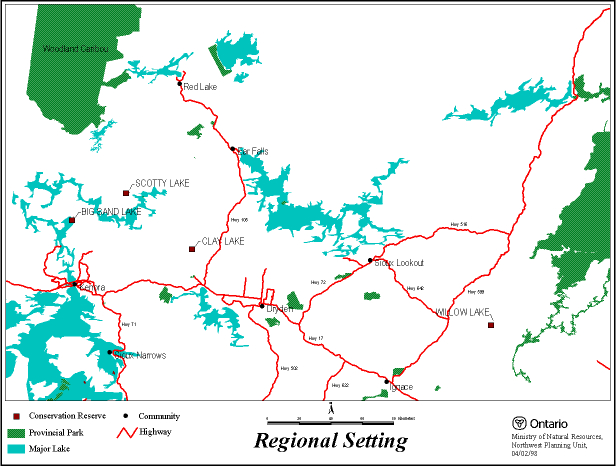
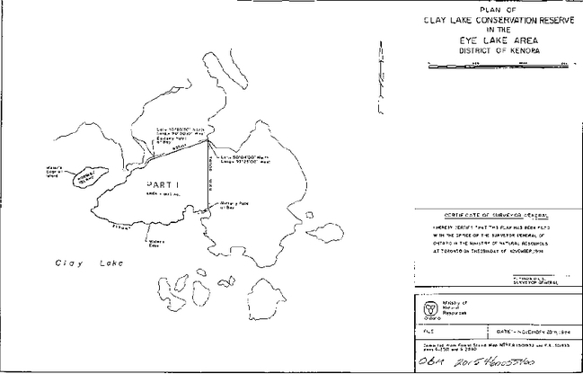
Figure 2: Clay Lake Conservation Reserve Boundary