Constant Creek Swamp and Fen Conservation Reserve Management Statement
This document provides policy direction for the protection, development and management of the Constant Creek Swamp and Fen Conservation Reserve and its resources.
Approval statement
We are pleased to approve this Statement of Conservation Interest (SCI) for the proposed Constant Creek Swamp and Fen Conservation Reserve. It is one of 378 new protected areas approved through Ontario’s Living Legacy, a land use strategy aimed, in part, at completing Ontario’s system of parks and protected areas.
The proposed Constant Creek Swamp and Fen Conservation Reserve is a 540 ha area of crown land located within the geographic townships Bagot and Blithfield in the County of Renfrew. Situated within ecological Site District 5E-11, the proposed reserve represents an area of undisturbed swamp and fen, bisected by a riverine system (Constant Creek) in the southern portion. The flatland is a product of a post-glacial spillway with ridges of marble and granite running through the site creating a series of linear wetlands that have matured into fens. The mixture of deciduous and coniferous swamps, interrupted by large and open grassy fens, represents the best collection of these habitats in the area.
This proposed conservation reserve is situated within an area of eastern Ontario encompassed by the Algonquin Nation land claim. The Ministry of Natural Resources and the Algonquin Nation are developing a protocol to guide discussions on a number of land use matters, including implementation of Ontario’s Living Legacy Land Use Strategy.
The proposed Constant Creek Swamp and Fen site has unique values that would benefit from protection at this time. The values at this site may be expanded in the future with the identification of other unique values through the protocol consultation process with the Algonquins. This SCI will protect the values of this site during the consultation process.
This Statement of Conservation Interest provides guidance for the management of the proposed Constant Creek Swamp and Fen Conservation Reserve and provides the basis for the ongoing monitoring of activities. More detailed direction is not anticipated at this time.
The proposed Constant Creek Swamp and Fen Conservation Reserve is managed under the jurisdiction of the Madawaska Area Supervisor, Pembroke District, Ministry of Natural Resources.
Approved by:
Ray Bonenberg
District Manager
Pembroke District
Date
Approved by:
Ron Running
Regional Director
Southcentral Region
Date
1.0 Introduction
The purpose of this Statement of Conservation Interest (SCI) is to identify and describe the values of the proposed Constant Creek Swamp and Fen Conservation Reserve. The SCI also outlines the activities that occur within the proposed reserve and provides guidelines for the management of current and future activities in the context of protecting the natural and cultural values.
Located within the geographic townships of Bagot and Blithfield, in the County of Renfrew, the proposed Constant Creek Swamp and Fen Conservation Reserve is a 540 ha area of undisturbed swamp and fen, bisected by a riverine system (Constant Creek) in the southern portion.
The proposed reserve is found approximately 25 kilometres south west of the town of Renfrew and 7 km west of Calabogie (see Figure 1). The portion of the proposed conservation reserve within Blithfield Township includes part of Lot 28, Concession 12. The remainder of the propos ed reserve falls within Bagot Township on parts of the following: Lot 22, 23, 24, 25, 26, and 27, Concession 1; Lot 23, 24, 25, 26, and 27, Concession 2; Lot 23, 24, and 25, Concession 3.
Lying within ecological Site District 5E-11, the proposed reserve protects most of the Crown land portion of the proposed Constant Creek Swamp and Fen Area of Natural and Scientific Interest (candidate Provincial ANSI) as well as a portion of the Ferguson Lake Provincially Significant Wetland (PSW) (see Figure 2).
Prior to the finalization of the boundaries of the proposed Constant Creek Swamp and Fen Conservation Reserve, Pembroke District MNR staff sent out boundary consultation packages to potentially affected stakeholders (adjacent landowners, resource users, municipalities, interest groups, and organizations), inviting comment on the proposed boundaries. Boundary consultation packages were also sent out to provincial interest groups and organizations. In addition, public notices were placed in local newspapers.
There were six responses received as a result of public consultation; one involved a request to widen an existing trail for road access across the proposed conservation reserve to private land.
Conservation Reserves are established by Regulation under the Public Lands Act. Statements of Conservation Interest are prepared under the authority of Procedural Guideline A – Resource Management Planning (PL Procedure 3.03.05).
1.1 Background information
| Name | Constant Creek Swamp and Fen (Proposed) Conservation Reserve |
|---|---|
| Ecological Site Region / Site District | 5E-11 |
| OMNR Administrative Region/District/Area | Southcentral Region /Pembroke District / Madawaska Area |
| Total Area (hectares) | 540 ha |
| Regulation Date | Pending |
| First Nations Interests | Algonquins |
| OBM map sheets | 10 18 3550 50150 |
| UTM Coordinates | 10 18 / 358500 E /5018500 N (NAD 27) |
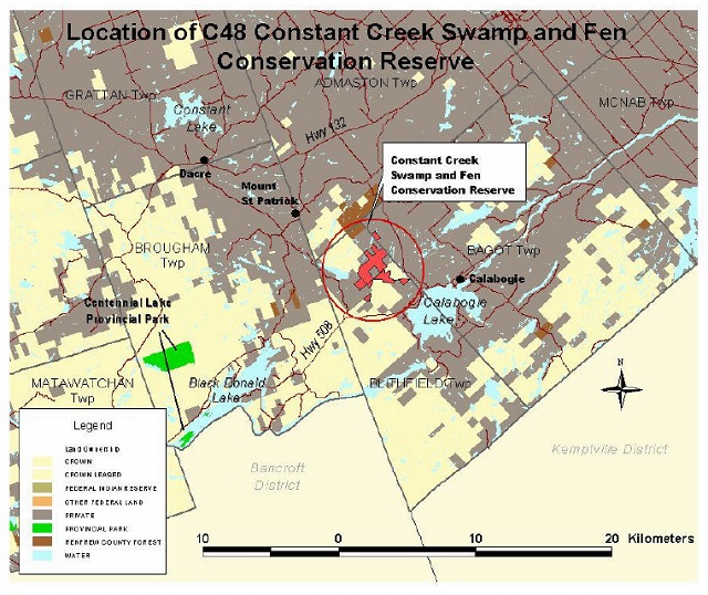
Enlarge Figure 1: Location of Constant Creek Swamp and Fen Conservation Reserve (PDF)
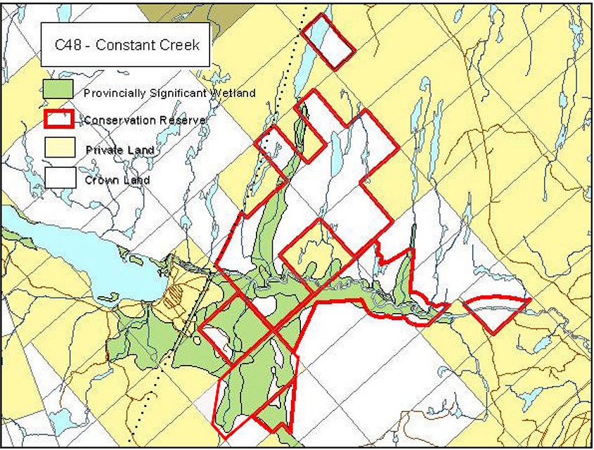
Enlarge Figure 2: Site Map of Constant Creek Swamp and Fen Conservation Reserve (PDF)
1.2 Representation/targets
Earth science representation:
Within Ontario’s protected areas system, the bedrock geology of the proposed Constant Creek Swamp and Fen Conservation Reserve has regional significance in its representation of felsic plutonic components of the Bancroft Terrane. Surficial geology is locally significant in its representation of till and glaciofluvial outwash deposits of the Wisconsinan Stage of the Quaternary Era (Frey & Duba, 2001).
Life science representation:
The proposed reserve encompasses approximately 60% of the Constant Creek Swamp and Fen ANSI. The swamp-over-marble combination is a distinct feature, with the mixture of deciduous and coniferous swamps interrupted by large and open grassy fens, being the best collection of these habitats in the area (OMNR, 2001). This area can be considered to contain the largest undisturbed Silver Maple swamp over marble substrate for ecological Site Districts 5E-9, 5E-10, and 5E-11. The extensive fen ecosites are unique in the ecological Site District, and possibly in all of the Georgian Bay – Ottawa Valley Region (ecological Site District 5E-7 to 5E11, 6E-16) (NHIC, 2002).
The proposed Constant Creek Swamp and Fen Conservation Reserve also protects approximately 60% of the larger Ferguson Lake Provincially Significant Wetland (PSW). Marsh, swamp and bog portions of the PSW are all represented by the proposed conservation reserve.
Cultural resources representation:
There are no known archeological sites within the proposed conservation reserve. However, the area is known to have a history of occupation spanning 5000 to 6000 years (Archaic; Early, Middle and Late Woodland; Early Historic) (Dillon Consulting, 1997). Cultural resources inventories have not been completed for this proposed conservation reserve, however, since water courses provided food and transportation for native populations, the most reliable assessment of archeological potential might be based on proximity to water (Dillon, 1997). With this in mind, it could be surmised that Constant Creek and the associated uplands may have been utilized for human occupation and exploitation.
1.3 Survey information
| Survey Level | Earth Sciences | Life Sciences | Cultural | Recreational | Other |
|---|---|---|---|---|---|
| Reconnaissance | Earth Science Checksheet-(Frey & Duba, (2001). | Life Science Check-sheet (Merchant 2002) | None known | Recreation Inventory Report (Moore, 2002) | Wetland Evaluation (Beaudette & Tubman - 1986); Life Science ANSIs in Site District 5E-11, (Brunton -1989); Final Tech Reports: Hwy 17 Env’ntal Assessmt (Dillon Consult., 1995 & 1997) |
| Detailed | no | no | no | no | no |
| Requirement | no | yes | yes | no | no |
2.0 Values to be protected
This section provides a description of the key natural heritage values of the site and their condition relative to past and present resource use and management activities. It also addresses the sensitivity of these values to future land use and management activities.
This proposed conservation reserve is located within Hills (1959) ecological Site District 5E-11. Values include earth science, life science and recreational features.
2.1 Earth science
According to Frey & Duba (2001), earth science values are focused on features (bedrock and surficial) that represent the chronology of earth history in the province.
The proposed Constant Creek Swamp and Fen Conservation Reserve is an area of swamp and fen surrounded by linear bedrock-controlled ridges.
Bedrock in the proposed Constant Creek Swamp and Fen Conservation Reserve commonly occurs as narrow, north trending ridges and rare small outcrops along the shorelines of larger lakes. The calcareous metasedimentary rocks mostly underlie the low elevation areas and wetlands. These rocks are poorly resistant to weathering and are not well exposed. The dominant rock type is quartzofeldspathic gneiss derived from quartz diorite of the Bancroft Terrane, in the eastern part of the Central Metasedimentary Belt of the Proterozoic Grenville Province.
The Bancroft Terrane is one of five lithotectonic terranes of the Central Metasedimentary Belt. As such, its representation in the proposed Constant Creek Swamp and Fen Conservation Reserve contributes to the conservation of the Grenville continental accretion theme.
The Quaternary glacial deposits in the area are Wisconsinan in age. The till resting on the bedrock was deposited by the continental glacial ice sheet that occupied the Ottawa Valley for at least 60,000 years, prior to the influx of the Champlain Sea into the region about 11,000 years ago. The younger glacial deposits were emplaced during the northwest retreat of the ice sheet up the Ottawa Valley as the Champlain Sea lapped against it.
The dominant glacial deposit is a very thin (<0.5 metre) and discontinuous till deposited as ground moraine. It is usually stoney, sandy and the clasts reflect the local bedrock geology. Thicker accumulations are found only in the valley bottoms.
The glaciofluvial outwash deposits occur as isolated patches within the swamp south of Constant Creek and southeast of Ferguson Lake. These were deposited in the fault-controlled valley of Constant Creek by southeastern flowing meltwater streams of the retreating ice front. Recent deposits are represented by swam and organic matter in the central and northeastern part of the proposed reserve. Several gravel and sand pits occur in meltwater channels of Constant Creek just outside of the proposed conservation reserve near its southwestern corner.
Historically, the region was staked for asbestos and molybdenum. Both of these prospects and a small molybdenite showing (about 0.6 km east of Culhanes Lake) occur outside of the proposed reserve boundaries.
2.2 Life science
The proposed Constant Creek Swamp and Fen Conservation Reserve is located within Hills’ (1959) ecological Site District 5E-11.
Representation:
The proposed Constant Creek Swamp and Fen Conservation Reserve lies along a stretch of Constant Creek between Fergusons Lake and Calabogie Lake. It is part of a provincially significant life science ANSI. The silver maple – green ash swamp represented here is the largest over marble substrate in ecological Site District 5E-11.
The river follows a spillway that was directed southeast by the St. Patrick Escarpment, a fault-line that marks the southwestern edge of the low-elevation Ottawa-Bonnechere Graben (Chapman and Putnam, 1984). Most of the stretch of Constant Creek in the proposed reserve is shallow, slow and meandering, over a sandy outwash bottom. The silver maple – green ash swamp flanks most of the river. Understorey is predominantly tall ferns and shrubs. A few places along the river, and along streams coming into the river, are mucky bottoms and marshy vegetation. At the eastern end of the proposed reserve, the marble substrate meets granite and the nature of the creek and the riparian vegetation changes: here, bedrock controlled till supports cedar and white pine-mixedwoods. As the river moves out of the proposed reserve, the bottom becomes stony and the current increases as it flows towards Calabogie Lake.
The ANSI was also recognized for its “magnificent set of open, graminoid fen meadows, some with pools and shrubby islands within them” (Merchant, 2002). These fens are unique in the ecological Site District, and possibly unique in the Georgian Bay-Ottawa Valley region. They drain into Constant Creek from the north, and are typically long and thin with a north-south axis. Along with the gram inoid fens are treed and shrub fens. These ecosites are well represented within the proposed reserve’s boundaries. Air photos show a number of beaver dams, which may be responsible for maintaining these fen ecosites. Between the wetlands are strips of upland areas composed of various mixtures of white cedar, poplar, white pine, red pine, balsam fir, red maple and red oak on shallow till. Exposed bedrock ridges also run north and south.
South of the river, the proposed reserve’s boundary is approximately 120 m from the water, but dips down on the northwest side to include a portion of a large white cedar-black ash-tamarack swamp.
While the proposed Constant Creek Swamp and Fen Conservation Reserve provides good representation of the above described communities, the parcel was originally identified for protection area regulation due to its significant wetland values, not on the basis of life science representation.
Condition:
The river is blocked in many places by fallen trees, logs, branches and beaver dams. Most of the swamps support mature trees, but some have extensive white cedar and silver maple mortality, leaving standing snags, cavity trees, downed woody debris, and sparse, young white cedar.
No human disturbance was noted within the proposed reserve. A parcel of private land surrounded by the proposed reserve contains a white pine cutover.
Diversity:
Ecosystem diversity along the river is low. In fact, the extent of the dominant ecosite in this area, deciduous mineral swamp, is remarkable. Only a few small areas of marsh and upland shallow till are present. However, species diversity within the riparian ecosites is high. Species that occur only on the southern fringes of ecological Site Region 5E are present, such as buttonbush and nannyberry. The rich, fluvial site conditions support dense understorey vegetation composed mostly of tall shrubs, grasses and ferns.
Information on the wetland and upland ecosites in the north was obtained by aerial reconnaissance and Forest Resource Inventory, which indicate higher landscape and ecosite diversity. In this area are treed fen, shrub fen, graminoid fen and ponds as well as mixedwoods on shallow till, scattered white pine on very shallow till and exposed bedrock outcrops and bedrock ridges.
Many wildlife trails were noted, and good wildlife habitat is provided by tall shrubs, standing snags and downed woody debris. Species observed include deer, beaver, wood duck, and bullfrogs.
Ecological considerations:
The boundaries of this proposed reserve are irregular, at places jogging in and out according to Crown ownership and determined by distance from the river in some areas. In some cases boundary recognition can be very difficult. The boundary definitions leave few places that are more than a few hundred metres from private land. However, the land directly surrounding the proposed reserve is also dominated by wetlands, and is mostly undeveloped. Cleared land approaches the border in the southwest. Long wetlands and distance from roads make access difficult.
A hydro line runs just east of the proposed reserve, forming part of the proposed conservation reserve’s boundary in two small sections.
Special features:
The proposed reserve harbours the largest undisturbed silver maple swamp over marble substrate for ecological Site Districts 5E- 9, 10, and 11.
Extensive fen ecosites are a unique feature in the ecological Site District, and possibly in all of the Georgian Bay – Ottawa Valley Region (ecological Site Districts 5E-7 to 5E11, 6E-16) (Merchant, 2002).
Significance:
Marsh, swamp and bog portions of the larger Ferguson Lake Provincially Significant Wetland are represented as well as portions of the proposed Constant Creek Swamp and Fen ANSI. The organic/mineral swamp-over-marble combination, large, open grassy fens, upland mixedwoods and upland white cedar on shallow till provide significant representation.
2.3 Recreational values
As the meandering river-course of Constant Creek turns into small waterfalls and rapids, many types of terrestrial and aquatic vegetation provide diverse habitat for numerous species of wildlife including waterbirds, furbearers, and larger mammals such as deer, black bear and wolf. Canoeing, natural heritage appreciation, sport fishing and hunting opportunities exist.
Of note is that the proposed Constant Creek Swamp and Fen Conservation Reserve has no existing road or trail access. Thus, with the exception of receiving permission of adjacent landowners, or travelling a distance across adjacent Crown land, the recreation features of the proposed reserve are relatively inaccessible.
Due to its lack of public access as well as the fact that the recreational uses (both consumptive and non-consumptive) can be located elsewhere on the landscape, the recreational features of proposed reserve are considered locally significant and likely underutilized at this time.
The location of the proposed reserve within the southern portion of the district does however, place it closer to a larger population base, thus providing potential ecotourism opportunities in the future.
3.0 Management guidelines
3.1 Land tenure
Background:
The proposed Constant Creek Swamp and Fen Conservation Reserve is a 540 ha area comprised of six separate parcels of Crown land. As part of the Constant Creek watershed (2KE-3), it lies within the Lower Madawaska River watershed of the Ottawa Valley.
The proposed reserve protects most of the Crown land portion of the proposed Constant Creek Swamp and Fen Area of Natural and Scientific Interest (candidate Provincial ANSI) as well as a portion of the Ferguson Lake Provincially Significant Wetland (PSW).
The unopened road allowances within the property are municipally owned and are not considered part of the proposed reserve.
There is currently one provincial land use permit (LUP) associated with this site (Ontario Power Generation corridor). Crown land fur harvesting occurs and the proposed conservation reserve is also part of a commercial baitfish harvesting zone and a Bear Management Area (BMA).
Due to the absence of existing roads or trails, direct access to the proposed Constant Creek Swamp and Fen Conservation Reserve is not readily available. Permission to cross private land or travelling a distance across adjacent Crown land is required in order to reach the proposed reserve.
One significant issue was raised during public consultation; a landowner expressed a desire to enlarge a trail across the proposed reserve in order to access his property via a wider roadway. (in the introduction is was called a “road access request”.
Guideline:
Sale of Crown lands within the proposed conservation reserve is not permitted, with the exception of some types of minor dispositions in support of existing uses (e.g., Land Use Permits or Licenses of Occupation). Renewals of existing land use permits are permitted. New leases or land use permits will be allowed for approved activities (see Appendix 1).
Leasing of Crown lands within the proposed conservation reserve for the development of private camps is not permitted.
Leasing of Crown lands to new commercial outfitting services, outpost camps, resort or lodges can be considered during future planning, however, it is very unlikely that such use will be proposed in this site. Currently, there are no “remote” based tourism lodges or camps on Crown land with exclusive tenure to an area in Pembroke District. There are numerous lodges, resorts, motels and cottages on private land which house tourists who use nearby Crown land and lakes for recreation activities (Yaraskavitch, ca 1997-98).
Lands that would enhance the proposed conservation reserve, by incorporating more of the provincially significant wetland, or by providing more public access to the site, may be purchased if funding and/or contributing partners become available. Should the municipality be willing, the acquisition by the Crown of the unopened municipal road allowances within the proposed reserve would benefit the consolidation and long term protected area management of this property.
Unauthorized occupations of lands within the proposed conservation reserve will be handled in accordance with approved policy, and any required structural removal will be undertaken at the owner’s expense.
3.2 Existing/proposed development
Background:
Currently, there is no known development within the site other than a trail that crosses the northern- most parcel in order to access private property. There is no intention at this time to upgrade the trail to a roadway or to improve site development in general (facilities, access, and trails).
Access to the site is limited to canoeing Constant Creek, obtaining permission to cross private land, or travelling a distance across adjacent Crown land.
Guideline:
New trails are discouraged, however, they may be considered when compatible with other recreational uses, the maintenance of environmental integrity, and the requirements of Procedural Guideline B – Test of Compatibility (Appendix 1). Any new trails will be designed to avoid those areas identified as sensitive to disturbance, or supporting provincially, regionally, or locally important plant species.
Facility infrastructure and development for recreational and/or educational purposes may be considered in the future if there is a demonstrated demand for such facilities. A more detailed management plan would be required at that time.
All provincial policies that guide development (i.e. water hazard management, wetlands) are applicable in conservation reserves as on Crown land.
3.3 Recreational activities
Background:
Although access to Constant Creek for the purpose of canoeing is limited, the activity proves to be rewarding for those who either boat in from Ferguson Lake or obtain permission to cross private land and launch their canoe. Numerous forms of wildlife and habitats enrich the shores of Constant Creek.
As the summer progresses and water levels drop, navigation of Constant Creek becomes more difficult. Ultimately, the canoe provides an excellent vantagepoint for admiring the serenity of Constant Creek.
Constant Creek supports a diverse number of fish species such as bass, walleye and pike. The highest abundance of game fish is likely found closer to west side of proposed reserve at the mouth of Ferguson Lake (also known as Constos Lake). Culhane Lake inside the proposed reserve may also provide a number of fishing opportunities. An aerial reconnaissance visit to the site in February of 2002, revealed that there is some ice fishing taking place, however it is assumed that pressure is low.
The proposed reserve is also part of the Admaston/Ashdad Deer Yard. Stratum-1 Core Deer Yarding habitat is found to the north and south of the proposed reserve. These are areas where deer are known to historically congregate during severe winters when snow gets deep (>60 cm). The entire proposed conservation reserve lies within a Stratum 2 Deer Yard which is considered a general deer yarding area. Deer usually congregate in these areas in early winter and in winters when conditions are not too severe. The population appears to be healthy and abundant. Deer hunting is known to be taking place within the proposed reserve, however there is no accurate assessment of hunting pressure. It is unlikely that hunting activities extend beyond adjacent landowners and their families. This is due primarily to the lack of public access to the site.
Although a popular sport in Renfrew County, it is unknown if waterfowl hunting is taking place within the proposed reserve. Waterfowl with young were seen during field visits (2001), and the presence of extensive hardwood swamps and marshy areas provide good wood duck and hooded merganser nesting areas.
The proposed reserve is presently utilized in a limited manner for hunting, fishing and canoeing. Activities such as natural heritage appreciation, photography, birdwatching, and nature study are also available, although limited due to access difficulties.
Aside from the trail that crosses the northern-most parcel of the site in order to access private property, there are no other known trails within the proposed Constant Creek Swamp and Fen Conservation Reserve; thus winter activities in the form of snowmobiling, skiing, or snowshoeing are limited. It should be noted however, that snowmobiling is becoming an increasingly popular winter activity in the Ottawa Valley. Although it is possible to access the proposed reserve via the frozen creek or hydro line on the west side of the proposed reserve, it is unlikely that anyone is currently participating in these activities.
Guideline:
Most recreational activities that have traditionally been enjoyed in this area can continue provided they pose little threat to the natural ecosystems and features protected by the proposed conservation reserve. Permitted uses include wildlife viewing, hiking, hunting, snowshoeing, cross- country skiing, exploring and fishing. Activities such as snowmobiling and the use of all-terrain vehicles (ATVs) will be permitted only on existing roads and trails where they do not adversely affect the values being protected. Off-trail mechanized travel is permitted only for the direct retrieval of game.
3.4 Commercial activities
Background:
Crown land fur harvesting occurs within the site, and the proposed conservation reserve is also part of a commercial baitfish harvesting zone and a Bear Management Area (BMA)
Guideline:
Some commercial uses (such as commercial fishing and fur harvesting) may be permitted in conservation reserves provided they do not impact the natural heritage values for which the area is established. Existing bait fishing use and Crown land fur harvesting are permitted to continue within the site unless there are demonstrated conflicts. New baitfish and fur harvesting operations can be considered subject to the requirements of Procedural Guideline B – Test of Compatibility (Appendix 1). No new fur harvesting cabins are permitted. New authorized non-resident bear hunting operations are not permitted, however new outpost camps, resorts, outfitting services or commercial food harvesting operations may be considered within the proposed reserve. It is however, very unlikely that such use will be proposed for this site.
Other new commercial activities must meet the requirements of Procedural Guideline B – Test of Compatibility, (Appendix 1). New transmission lines (e.g. power or communications), pipelines, and road corridors are discouraged through existing planning processes.
Mineral exploration and mining are not permitted within the proposed Constant Creek Swamp and Fen Conservation Reserve.
Conservation Reserves do not permit commercial forest harvesting, hydroelectric power development, the extraction of aggregate, peat, soils, or other industrial uses. (Public Lands Act, Ontario Regulation 805/94). Other new commercial activities must meet the requirements of Procedural Guideline B – Test of Compatibility.
3.5 Aboriginal interests
Background:
The proposed conservation reserve is located within the land claim area of the Algonquin Nation. There are no known archeological sites within the proposed Constant Creek Swamp and Fen Conservation Reserve, however, the area is known to have a history of occupation spanning 5000 to 6000 years (Archaic; Early, Middle and Late Woodland; Early Historic) (Dillon Consulting, 1995). Since water courses provided food and transportation for native populations, the most reliable assessment of archeological potential is based on proximity to water (Dillon, 1995). With this in mind, it could be surmised that Constant Creek and the associated uplands may have been utilized for human occupation and exploitation.
Guideline:
The Ministry of Natural Resources and the Algonquin Nation are developing a protocol to guide discussions on a number of land use matters, including implementation of the Ontario’s Living Legacy Land Use Strategy. The Constant Creek Swamp and Fen site has unique values that would benefit from protection at this time. The values at this site may be expanded in the future with the identification of other unique values through the protocol consultation process with the Algonquins.
Hunting and fishing are permitted uses in proposed conservation reserves.
3.6 Natural resource stewardship
3.6.1 General
This proposed conservation reserve will be managed with an emphasis on ensuring that the natural ecosystems and processes of the proposed reserve are not negatively affected by current and future activities. Therefore, applications for specific uses will be carefully studied and reviewed. The Ministry, partner organizations, and/or the proponents may undertake such studies.
3.6.2 Vegetation management and fire management
Background:
The swamp-over-marble combination of the proposed reserve provides for a mixture of deciduous and coniferous swamps and large and open grassy fens (OMNR, 2001). An evaluation of the FRI information found that approximately 73% of the proposed reserve is considered productive forest, 20% is treed muskeg, and the remainder is a combination of small amounts of developed agriculture land, rock, brush/alder, and water.
The complex geology results in variable vegetation and floral cover, especially north of the river where the highest landscape diversity is found. This includes: large, open graminoid fen meadows, treed and shrub fens, ponds, shallow wetlands, mixedwoods of white cedar, poplar, white pine, red pine, balsam fir, red maple and red oak, as well as flora associated with exposed bedrock outcrops and bedrock ridges.
Silver maple-green ash swamps flank the meandering banks of Constant Creek in the southern portion of the proposed reserve. Understorey is predominantly tall ferns and shrubs with some marshy areas.
At the eastern end of the proposed reserve, the marble substrate meets granite, and the nature of the creek and the riparian vegetation changes into cedar and white pine-mixedwoods.
Guideline:
The proposed conservation reserve will be managed by allowing natural ecosystems, processes and features to operate normally, with minimal human interference or alteration.
Conservation reserve policy states that forest fire protection will be carried out in the proposed reserve as on surrounding public lands, unless it is determined through management planning that another approach should be undertaken. Pembroke District MNR has a policy of aggressively suppressing all fires. The MNR would appropriately respond to any fire as per policy or municipal agreements at any such time, with a “light on the land” approach (i.e., no bulldozers, no camp construction, minimal cutting).
Programs may be developed to control forest insects and diseases in the proposed conservation reserve where these threaten significant natural heritage, aesthetic, or economic values. Where control is desirable, it will be directed as narrowly as possible to the specific insect or disease. The methods selected will be subject to the requirements of Procedural Guideline B – Test of Compatibility (Appendix 1).
Any habitat alterations would be reviewed on a case by case basis, with consideration given to the protection of natural heritage values, OMNR’s environmental assessment responsibilities and provincial conservation reserve policy.
Invasive species which are deemed to threaten the natural heritage values of the proposed conservation reserve will be managed using acceptable and approved controls which protect natural heritage values and are subject to Procedural Guideline B – Test of Compatibility (Appendix 1).
The Ministry of Natural Resources will continue to work with municipalities and private landowners to protect private land portions of the provincially significant wetland by way of land tax incentives, co-stewardship opportunities and through municipal land use planning. Landowners with property in a provincially significant wetland may be eligible for the Conservation Land Tax Incentive Program, providing they meet the program criteria and agree to protect the natural heritage values of their property. Protection of the wetland can also be promoted by municipal consideration of the Provincial Policy Statement and Planning Act within planning documents and through development review.
3.6.2 Fish and wildlife management
Background:
The proposed reserve is located within an extensive natural landscape of forest and marginal agriculture land. A hydro line is found along the western side of the proposed reserve, possibly serving as a corridor for wildlife movement.
An abundance of species such as dragonflies, turtles, waterfowl, numerous fish species, fresh water clams, and white-tailed deer are easily viewed as one paddles down Constant Creek.
The wooded swamps and river bottomlands provide wood duck and hooded merganser breeding habitat with the emergent, floating and submergent aquatic vegetation providing valuable sources of food and cover.
Wetland features that continue along the creek also provide habitat for such popular fur-bearing species as beaver, mink, river otter, and muskrat. Bullfrogs, another species managed for consumption, are known to exist within Constant Creek as are relatively high numbers of white- tailed deer. The proposed Constant Creek Swamp and Fen Conservation Reserve is part of the Admaston/Ashdad Deer Yard. An estimate of carrying capacity and winter forage supplies was recently completed (Rosien, 2001). It was determined that the browse biomass was estimated at approximately 13.23 kg/ha, and the winter carrying capacity of the yard was estimated at approximately 10.74 deer/km2.
During field visits many wildlife trails were noted, as were tracks in the sandy shoals of the river. Species observed include deer, beaver, wood duck, great blue heron, and kingbird. Two heronries exist adjacent to the western boundary of the proposed reserve. As many as 17 nests were recorded in one location during an aerial survey in 2002.
Guideline:
Activities such as nature appreciation, photography and wildlife viewing are all permitted uses. Fisheries management within the proposed reserve will be guided by the fishing regulations associated with Division 15 of the Central Ontario Region.
The management of game and fur species in the proposed conservation reserve will continue to be consistent with the wildlife management unit (WMU 59) within which it lies.
Hunting within the proposed conservation reserve may continue and will be guided by the relevant Ontario hunting regulations. Although bait-fish harvesting and Crown land fur harvesting currently exist in the proposed reserve, new bait-fish harvesting operations and commercial fur harvesting operations could be considered if necessary, subject to the requirements of Procedural Guideline B– Test of Compatibility (Appendix 1). Fur harvesting and bait-fishing would be managed through the current licencing system.
Any habitat alterations would be reviewed on a case by case basis, with consideration given to protection of natural heritage values, OMNR’s environmental assessment responsibilities and provincial conservation reserve policy.
Invasive species which are deemed to threaten the natural heritage values of the proposed conservation reserve will be managed using acceptable and approved controls which protect natural heritage values while being subject to Procedural Guideline B – Test of Compatibility (Appendix 1).
3.7 Cultural resource stewardship
Background:
The protection and conservation of cultural heritage resources is governed by the Ontario Heritage Act and administered by the Ministry of Culture. There are no known cultural/historic features and archeological features identified on site although Aboriginal and historical values have been identified in the area.
Guideline:
Interested partners with the appropriate qualifications would be allowed to undertake inventories and studies of the area, consistent with Procedural Guideline C - Research Activities in Conservation Reserves (Appendix 2). The specific location of cultural heritage sites will be kept confidential to protect the resources.
3.8 Client services
Client services (such as interpretation, access and signage) associated with the site are limited to a brief informative fact sheet that was developed during the public consultation phase in 1999. No services or facilities are presently provided within the site boundaries. The Fact Sheet for the proposed Constant Creek Swamp and Fen Conservation Reserve is currently available to the public through the Pembroke District office or via the internet at: www.ontarioslivinglegacy.com [link inactive].
Guideline:
Given the focus on low key management, client information will be given on an inquiry basis only and will deal with the basic level of information with respect to access, natural heritage appreciation, recommended activities, and boundaries.
3.9 Research
Background:
Beaudette and Tubman completed a wetland evaluation of the Ferguson’s Lake Wetland (of which this site is a part) in 1986. This area was ranked as Provincially Significant within Ontario. As well, D.F. Brunton completed Life Science Inventory Checksheet as part of an ANSI report for in Site District 5E-10 in 1989.
As part of the responsibilities associated with the regulation of the proposed reserve, three additional reports were completed and can be found on file with the Ministry of Natural Resources at the Pembroke District office. They are as follows:
- Natural Heritage Area – Life Science Checksheet (Merchant, 2002) Recreation Resource Inventory Report (Moore, 2002); and,
- Earth Science Report (Frey & Duba, 2001).
Guideline:
A detailed bedrock and surficial geological inventory of the proposed Constant Creek Swamp and Fen Conservation Reserve is not warranted because of the extensive wetlands and bedrock exposure already mapped. Although resistant to most human activities, the bedrock exposures are susceptible to graffiti, uncontrolled bedrock sampling and unplanned bedrock disturbances. Appropriate cautionary warnings or controls should be implemented if increased access is promoted. The wetlands are sensitive to significant flooding or lowering of water levels through unplanned human disturbances. Such activity would damage the wetland ecosystem but have no effect on the exposed bedrock (Frey & Duba, 2001).
Cultural/historical inventories should be conducted within the site in order to determine the extent of Native archeological features.
In general, non-destructive research by qualified individuals will be encouraged to:
- provide a better understanding of the natural values protected by the proposed Constant Creek Swamp and Fen Conservation Reserve;
- Creek Swamp and Fen Conservation Reserve;
- monitor impacts of recreational use of the site; and,
- advance protection, planning and management of the proposed conservation reserve.
Research proposals and activities must follow Procedural Guideline C – Research Activities in Conservation Reserves (PL. Procedure 3.03.05) (Appendix 2).
All research programs will require the approval of the Ministry of Natural Resources as will the removal of any natural or cultural specimen. The establishment of permanent plots, observation points or facilities must also be approved and be compatible with the conservation reserve protection objective. Any site disturbed by research activities must be rehabilitated as closely as possible to its previous state. The researcher will submit copies of reports, publications, theses and results to the OMNR Madawaska Area Supervisor in Pembroke.
3.10 Marketing
Background:
There has been no direct marketing of the proposed Constant Creek Swamp and Fen Conservation Reserve to date. Promotion and information about this site has been distributed primarily through the Ontario’s Living Legacy planning process. This includes recent public consultation regarding the proposed regulation and boundary refinement of the site and through the Living Legacy website at www.ontarioslivinglegacy.com [link inactive].
Guideline:
Although potential may exist for additional eco-tourism opportunities, intensive marketing activity to increase recreational use of the proposed Constant Creek Swamp and Fen Conservation Reserve is neither desired nor required at this time. The fact sheets concerning this proposed conservation reserve will continue to be available to inform the public about the special values of this area and its role in Ontario’s protected areas system.
4.0 Implementation
Administrative responsibility for the proposed Constant Creek Swamp and Fen Conservation Reserve lies with the Madawaska Area, Pembroke District office of the Ministry of Natural Resources.
The Ministry will continue with the custodial care of the proposed conservation reserve and will also seek out partnerships where appropriate. Implementation of this Statement of Conservation Interest will primarily involve monitoring activities to ensure adherence to the management guidelines.
Implementation priorities include:
- consultation with Algonquin First Nation representatives and communities, as a basis of proceeding with final boundary refinement and regulation of this proposed conservation reserve;
- updating this SCI upon final regulation as a conservation reserve;
- undertaking additional life science, recreational and cultural/historical inventories and research and to monitor impacts of use;
- examining the potential opportunities of acquiring additional lands adjacent to or in close proximity of the proposed reserve;
- examining the potential to work with adjacent landowners through the local stewardship council and other partners to protect and enhance marsh wetland communities for staging and breeding waterfowl.
- providing client services (e.g. brochure or fact sheet) at nearby OMNR Offices;
- proceeding with minor development (e.g., signage, etc..) as funding permits; and,
- ongoing education of resource users with respect to resource and land stewardship values (e.g., brochures, working with adjacent landowners, municipalities, etc.) in order to provide long term recreational opportunities and maintain the ecological integrity of the site.
5.0 Review and revision of the statement of conservation interest
The proposed Constant Creek Swamp and Fen Conservation Reserve’s Statement of Conservation Interest will be reviewed on an ongoing basis.
If changes are required in the Statement of Conservation Interest, they will occur through a standard process of minor and major amendments. Minor amendments will be processed in a relatively informal manner and will require the approval of the Area Supervisor. These amendments will deal with uses and activities that do not affect any of the policies in this SCI, such as new uses and/or activities that are consistent with existing uses.
Uses and/or activities that were not anticipated in the approved SCI and which have the potential to have a negative impact on the values of this proposed conservation reserve will require a major amendment. This will include an opportunity for public comment and input, and will require the approval of the District Manager and Regional Director.
References
Beaudette, S. and K. Tubman. 1986. Wetland Evaluation and Data Record – Ferguson’s Lake. Second Edition. Ontario Ministry of Natural Resources.
Brunton, Daniel. January, 1989. Life Science Areas of Natural and Scientific Interest in Site District 5E-11: Life Science Inventory Check Sheet, Constant Creek Swamp and Fens. OMNR, (Parks).
Chapman L.J. and D.F. Putman. 1984. Physiography of Southern Ontario, Third Edition, Ontario Geological Survey of Special Volume 2.
Davidson R. J. 1981. A Framework for the Conservation of Ontario’s Earth Science Features. Ontario Ministry of Natural Resources, Toronto.
Dillon Consulting Limited. December,1997. Final Technical Reports: Highway 17 Environmental Assessment—Haley Station to Meath Hill—Terrestrial Biology and Wetlands.
Dillon Consulting Limited. March 7, 1995.Final Technical Reports: Highway 17 Environmental Assessment—Haley Station to Meath Hill—Environmental Assessment and Route Planning Study.
Frey, Edward and Daria Duba. October 2001. Earth Science Report – C48 Constant Creek Swamp and Fen Conservation Reserve.
Hills, G. A. 1959. A Ready Reference to the Description of the Land of Ontario and Its Productivity. Ontario Department of Lands and Forests, Division of Research, Maple, Ontario.
Merchant, Barb. February, 2002. Natural Heritage Area- Life Science Checksheet, Proposed Constant Creek Swamp and Fen Conservation Reserve.
Moore, T. March, 2002. Recreation Resource Inventory Report: Silver Creek Peatland Conservation Reserve (C61), OMNR.
Noble T. W. 1983. Biophysiographic Analysis of Site Region 5E. Central (Algonquin) Region, Ontario Ministry of Natural Resources.
Ontario Ministry of Natural Resources. July 2001. Constant Creek Swamp and Fen Conservation Reserve (C48) Fact Sheet.
Ontario Ministry of Natural Resources. 1987. Forest Resource Inventory Mapping (FRI) – Pembroke District.
Ontario Ministry of Natural Resources. February, 2002. Natural Resources Values Information System (NRVIS), Pembroke District.
Ontario Ministry of Natural Resources. July 1999. Ontario’s Living Legacy Land Use Strategy: Queens Printer for Ontario.
Ontario Ministry of Natural Resources. 1983. Pembroke District Land Use Guidelines. Pembroke District, Algonquin Region, Ontario Ministry of Natural Resources.
Rosien, Darwin. Fall 2001. An Estimate of Carrying Capacity (Kw) and Winter Forage Supplies in the Admaston/Ashdad Deer Yard. Sustainable Resources Environmental Consulting.
Yaraskavitch, Joe. March 11, 1998a. District Evaluation of Options-Proposed Natural Heritage Areas.
Appendix 1: Procedural guideline B – land uses – test of compatibility (PL procedure 3.03.05)
The Conservation Reserve policy provides broad direction with regard to the permitted uses. The policy provides only an indication of the variety of uses that will be considered acceptable in Conservation Reserves. The only caution is that “any new uses, and commercial activities associated with them, will be considered on a case by case basis, and, they must pass a test of compatibility to be acceptable”.
What does a ’test of compatibility’ mean? An examination of this must start from the premise of why an area is set aside – specifically, its representative natural heritage values. Criteria are then identified to guide compatibility considerations. These criteria apply to the long-term ac ceptability of both existing uses and new uses.
This should include the following:
- Conformity to SCI/RMP: SCI describes values for which an area has been set aside and the range of appropriate uses that will be permitted in the area. SCI may also speak to the acceptability of other ’new’ uses currently not occurring in the
The first ’test’ is: “do proposed new land uses and/or commercial activities conform to the direction of the SCI/RMP for the Conservation Reserve? Would the new use(s) depart from the spirit of appropriate indicator land uses in the SCI/RMP?”
- Impact Assessment: If the proposed use(s) pass test 1 it is important to determine their impact on the area before they are approved.
- Impact on natural heritage values: “will the new use(s) impact any natural values in the area? If so how and to what degree? Is it tolerable?”
- Impact on cultural values: “will the new use(s) impact an historical or archaeological valuesin the area?”
- Impact on research activities: “will the new use(s) affect research activities in the area?”
- Impact on current uses: “will the new use(s) have any negative impact on the array of current uses?”
- Impact on area administration: “will the new use(s) increase administrative costs and/or complexity?” (For example, the cost of area monitoring, security and enforcement).
- Impact on accommodating the use outside the Conservation Reserve: “Could the use(s) be accommodated as well or better outside the Conservation Reserve?”
- Impact on socio-economics of the area: “will the new use(s) affect the community (ies) surrounding the area in a positive or negative way?” (For example, will the new use make an area less remote thereby affecting a local tourism industry that is dependent on the area’s remoteness for its appeal?”
- Impact on area accessibility: “does the new use(s) give someone exclusive rights to the area or a portion of the area to the exclusion of other existing uses?”
Indicator uses for conservation reserves
| Activity |
Generic OLL policy Permitted? Existing |
Generic OLL policy Permitted? New |
Specific application In Proposed Constant Creek Swamp and Fen Conservation Reserve Existing |
Specific application In Proposed Constant Creek Swamp and Fen Conservation Reserve New |
|---|---|---|---|---|
| Commercial timber harvest | No | No | No | No |
| Cutting of trees by leaseholders and property owners for fuelwood and small-scale uses | Maybe | Maybe | Maybe | Maybe |
| Timber salvage/sunken log retrieval | Maybe | Maybe | Maybe | Maybe |
| Mineral exploration | No | No | No | No |
| Mining | No | No | No | No |
| Extraction of peat, soil, aggregate, other materials | No | No | No | No |
| Forest renewal | Maybe |
Maybe |
Maybe |
Maybe |
| Hydro power generation | No | No | No | No |
| Communications corridors | Yes | No |
Yes | No |
| Energy transmission corridors | Yes | No |
Yes | No |
| Transportation corridors | Yes | No |
Yes | No |
| Resource access roads | Maybe |
Maybe |
Maybe |
Maybe |
| Private access roads | Yes | No |
Yes | No |
| Activity |
Generic OLL policy Permitted? Existing |
Generic OLL policy Permitted? New |
Specific application In Proposed Constant Creek Swamp and Fen Conservation Reserve Existing | Specific application In Proposed Constant Creek Swamp and Fen Conservation Reserve New |
|---|---|---|---|---|
| Sport fishing | Yes | Yes | Yes | Yes |
| Sport hunting | Yes | Yes | Yes | Yes |
| Facility development | Maybe | Maybe | Maybe | Maybe |
| Non-trail snowmobiling | Maybe |
Maybe |
Maybe |
Maybe |
| Non-trail ATV use | Maybe |
Maybe |
Maybe |
Maybe |
| Motorized boating | Yes | Yes | Yes | Yes |
| Camping | Maybe | Maybe | Yes | Yes |
| Activity |
Generic OLL policy Permitted? |
Generic OLL policy Permitted? |
Specific application In Proposed Constant Creek Swamp and Fen Conservation Reserve Existing | Specific application In Proposed Constant Creek Swamp and Fen Conservation Reserve New |
|---|---|---|---|---|
| Hiking | Yes | Maybe | Yes | Maybe |
| Snowmobiling | Yes | Maybe | Yes | Maybe |
| Cycling | Yes | Maybe | Yes | Maybe |
| Horse riding | Yes | Maybe | Yes | Maybe |
| Cross-country skiing | Yes | Maybe | Yes | Maybe |
| Private recreation camps |
Yes |
No |
Yes |
No |
| Activity |
Generic OLL policy Permitted? |
Generic OLL policy Permitted? |
Specific application In Proposed Constant Creek Swamp and Fen Conservation Reserve Existing | Specific application In Proposed Constant Creek Swamp and Fen Conservation Reserve New |
|---|---|---|---|---|
| Fishing |
Yes |
Maybe |
Yes |
Maybe |
| Bait-fish harvesting | Yes |
Maybe |
Yes |
Maybe |
| Commercial fur trapping | Maybe | Maybe | ||
| Trapping cabin | Yes | No | Yes | No |
| Out-post camps/tourism facilities |
Maybe |
Maybe |
Maybe |
Maybe |
| Commercial bear hunting (tourist operators) | Yes | No | Yes | No |
| Wild rice harvesting | Yes |
Maybe |
Yes |
Maybe |
| Food harvesting | Maybe | Maybe | Maybe | Maybe |
| Activity |
Generic OLL policy Permitted? |
Generic OLL policy Permitted? |
Specific application In Proposed Constant Creek Swamp and Fen Conservation Reserve Existing | Specific application In Proposed Constant Creek Swamp and Fen Conservation Reserve New |
|---|---|---|---|---|
| Resource inventorying | Yes | Yes | Yes | Yes |
| Resource monitoring | Yes | Yes | Yes | Yes |
| Fire protection | Yes | Yes | Yes | Yes |
| Insect and disease | Maybe | Maybe | Maybe | Maybe |
| Featured species management | Maybe | Maybe | Maybe | Maybe |
| Activity |
Generic OLL policy Permitted? |
Generic OLL policy Permitted? |
Specific application In Proposed Constant Creek Swamp and Fen Conservation Reserve Existing | Specific application In Proposed Constant Creek Swamp and Fen Conservation Reserve New |
|---|---|---|---|---|
| Research | Yes | Yes | Yes | Yes |
| Collecting | M |
M |
M |
M |
| Food gathering | Yes | Yes | Yes | Yes |
| Land disposition | Yes |
Maybe |
Yes |
Maybe |
| Habitat management for wildlife | Maybe |
Maybe |
Maybe | Maybe |
Appendix 2: Procedural guideline C – research activities in conservation reserves
Purpose
To encourage contributions to the goal of conservation reserves by:
- providing direction for research activities associated with conservation reserves; and
- establishing a process for the review and approval of proposals by researchers, which could have an impact on the values protected by the conservation reserve.
Definition
Research means any investigation or study of the natural, cultural, social, economic, management or other features or characteristics of conservation reserves.
Guidelines
Research will be encouraged to provide a better understanding of the natural values protected by a conservation reserve and to advance their protection, planning and management. The Statement of Conservation Interest will define, for each conservation reserve, the key research issues, set out the parameters within which research may occur and identify research needs.
Applications and approvals
Researchers must apply in writing to the Area Supervisor for permission to conduct research. The request letter must contain a statement explaining why the proposed research should be undertaken in the particular conservation reserve in preference to another location.
Proposals will be reviewed and approved by the Area Supervisor, guided by the Statement of Conservation Interest prepared for each reserve (see Guideline A – Resource Management Planning) and using Guideline B – Land Uses – Test of Compatibility. Permission must be granted in writing, including any conditions to be met in conducting the research, prior to the undertaking of any research project.
Terms and conditions
Permission to conduct research under this policy will be valid for a period of 12 consecutive months from date of issue. Permission to continue a research project for additional periods of 12 months or less may be granted upon submission of a written request and progress report. The Ministry may require the posting of collateral to assure that the terms and conditions of granting permission are met.
The Area Supervisor may suspend or revoke permission at any time for failure on the part of the researcher to meet:
- The intent or conditions of this policy.
- The requirements under the Public Lands Act, including all amendments, where applicable.
- The requirements under any other Act or Regulations of Ontario or Canada, including those governing the taking, handling, storing, confining, trapping, excavating and marketing any specimen, artifact, information or action (for example, scientific collector’s permit).
- The conditions and agreements specified in granting permission.
Final report
The researcher will submit copies of reports, publications and theses following from the results of the project to the Area Supervisor.
Footnotes
- footnote[1] Back to paragraph The intent is to actively discourage these uses, but it is recognized that in some circumstances these will be no alternative; this will be determined through planning.
- footnote[2] Back to paragraph The intent is to actively discourage these uses, but it is recognized that in some circumstances these will be no alternative; this will be determined through planning.
- footnote[3] Back to paragraph New private access roads, including additions to existing roads, will not be permitted except where there are previous commitments that were made prior to March 29, 1999. Such commitments will be subject to the completion of a public planning process.
- footnote[4] Back to paragraph Use may be permitted for the direct retrieval of game only.
- footnote[5] Back to paragraph Existing private recreation camps are eligible for enhanced tenure but not for the purchase of lands. A decision to grant enhanced tenure, or to transfer recreational camps will be addressed though a screening process.
- footnote[6] Back to paragraph Existing use permitted to continue, unless there are significant demonstrated conflicts. New operations can be considered, subject to the ‘test of compatibility.’
- footnote[7] Back to paragraph Existing authorized tourism facilities can continue unless there are demonstrated conflicts. The operators of tourism facilities can apply to upgrade tenure from LUP to lease. New tourism facilities can be considered during planning for a conservation reserve.
- footnote[8] Back to paragraph Must be part of an authorized research project.
- footnote[9] Back to paragraph Sale of lands is not permitted with the exception of some minor types of dispositions where it does not detrimentally affect the values an area is intended to protect. Renewals of existing leases or land use permits are permitted. Requests for transfer of tenure will be considered in the context of the SCI. New leases or land use permits will be allowed for approved activities.
- footnote[10] Back to paragraph A specific policy was not identified in the OLL Land Use Strategy, although specific management prescriptions will be identified in the context of an SCI