Daisy Lake Uplands Provincial Park Management Statement
This document provides direction on the management of Daisy Lake Uplands Provincial Park.
Interim Management Statement
Ontario 2007
Approval statement
I am pleased to approve this Interim Management Statement for Daisy Lake Uplands Provincial Park. Ontario’s Living Legacy Land Use Strategy (1999) identified this area as a nature reserve class provincial park. This park was regulated under the Provincial Parks Act in June 2006 (O. Reg. 331/06).
This Interim Management Statement provides direction for the protection and management of Daisy Lake Provincial Park.
Signed by:
Paul Bewick, Manager
Northeast Zone
Ontario Parks
Date:
February 12, 2007
1.0 Introduction
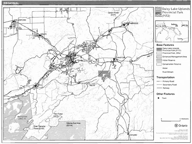
Daisy Lake Uplands Provincial Park is located in Dill and Neelon townships, within the limits of the City of Greater Sudbury (Figure 1). This nature reserve class park is 600 hectares in size (Figure 2).
Formerly designated as a Forest Reserve (FR), Daisy Lake Uplands Provincial Park is part of a larger landscape that has been disturbed by more than 100 years of pollution from nickel smelting and near urban development. The land use intent is to leave this site to recover naturally, instead of using restoration measures which have aided in the recovery of the surrounding area.
1.1 Objectives
Daisy Lake Provincial Park will be managed consistent with the two objectives for nature reserve class provincial parks:
Protection: To protect provincially significant elements of the natural and cultural landscapes of Ontario.
Heritage Appreciation: To provide opportunities for exploration and appreciation of the outdoor natural and cultural heritage of Ontario.
2.0 Management context
The purpose of this Interim Management Statement (IMS) is to provide direction to ensure the custodial management of park resources. Future park planning may be undertaken as required to provide direction on significant decisions regarding resource stewardship, development, operations and permitted uses.
Park management will follow direction from:
- Provincial Parks Act (1990) and regulations
- Ontario Provincial Parks Planning and Management Policies (OMNR 1992)
- Ontario’s Living Legacy Land Use Strategy (OMNR 1999} and policy clarifications (OMNR 2000}, amendments, and related direction
- Crown Land Use Policy Atlas (OMNR 2004a).
In addressing custodial management obligations to protect park values and ensure public health and safety, Ontario Parks will ensure that policy and Environmental Assessment Act (1990) requirements are implemented.
2.1 Environmental assessment
As a part of the Ontario Ministry of Natural Resources (MNR), Ontario Parks is a public sector agency which is subject to the Environmental Assessment Act. Park management will be carried out in accordance with legislation, policies, and guidelines that are required under A Class Environmental Assessment for Provincial Parks and Conservation Reserves (OMNR 2005).
3.0 Park features and values
Daisy Lake Uplands Provincial Park protects recovering ecosystems in Ecodistrict SE-4. Young White Birch, grasses, sedges, rock barrens, and acid-tolerant bog vegetation covers the site. The park is situated in strongly broken, shallow, sandy till uplands.
Figure 2: Regional context
Figure 2: Park boundary

3.1 Geological features
The boundary between the Southern Province and the Grenville Province, two major geological provinces, passes through the southern portion of the park. In addition, a major fault runs underneath Daisy Lake and Baby Lake. There is evidence of folding and partial metamorphosis of the bedrock, which occurred 1.8 to 1.6 billion years during a mountain-building period (Morris 2000). Bedrock surfaces are blackened and visibly etched as a result of industrial atmospheric pollution, popularly referred to as acid rain.
Surficial deposits consist of thin glacial drift in the valley slopes between bedrock outcrops.
3.2 Biological features
Daisy Lake Uplands Provincial Park is representative of the Sudbury area landscape, which has been disturbed by more than 100 years of forestry, prospecting, mining, and smelting, and urbanization. Soils in the park were heavily eroded due to deforestation, which was caused by the effects of local smelter emissions, and wood harvesting to fuel a roast bed located two-and-a-half kilometres to the east. Soils were also affected by forest fires, which were caused by sparks from the railway line and early prospectors who used fire to clear the land. The site is fragmented by Highway 17 bypass in the west and the Canadian Pacific Railway (CPR) line in the east. The extensive amount of disturbance has severely reduced the biological diversity here and elsewhere on the Sudbury landscape. In essence, the representative and special features of Daisy Lake Uplands Provincial Park are the pioneer plant communities that have re-grown in this area in response to the industrial and urban disturbances (Morris 2000).
A headwater divide splits Daisy Lake Uplands Provincial Park. Daisy Lake and most of the park area drains into the Whitefish River system, while Baby Lake and a large portion of the park drains into the Wanapitei River.
The park lies within the northern limits of the Great Lakes-St. Lawrence forest region. Prior to industrial development of the Sudbury region forests in the area included white and red pine with red oak on dryer rock sites and sugar maple and yellow birch on sites with deeper soils. Today, large stumps are all that remain as evidence of large pine that grew here. Populations of metal tolerant grass, sedge, and early successional white birch and poplar tree species occur in the park. These ecotypes are of considerable interest to academics studying plant physiology and the mineral nutrition of plants, as well as applied biologists looking to use or develop metal tolerant strains of native species for land reclamation in boreal and sub-boreal forest regions (Morris 2000).
3.3 Cultural setting
A detailed survey and analysis of the cultural history and features of Daisy Lake Uplands Provincial Park has not been completed to date.
Any future planning will be within the context of a provincial framework, A Topical Organization of Ontario History (OMNR 1974). In addition, updates and discussions with First Nations, other agencies and stakeholders may be carried out to identify cultural heritage values and features within the park and their significance. This information may be used to develop management guidelines to conserve and protect representative archaeological and historical values and features, or to provide direction for further research.
3.4 Recreation
The protection, recovery, and maintenance of environmental quality and values are fundamental to the management of Daisy Lake Uplands Provincial Park. Nature reserve policies ensure thatnature is allowed to function freely, within the constraints of public safety and the need to protect values within and adjacent to the nature reserve.
The park could offer a variety of low-intensity recreational uses, such as canoeing, hiking, nature appreciation and exploring. Unauthorized snowmobile and all-terrain vehicle (ATV) use may occur in this area. Future management planning will review all uses, including snowmobile and ATV use, to ensure that park features and values are protected, and to assess the potential for these uses to conflict with park values and other uses.
4.0 Aboriginal uses
Daisy Lake Uplands lies within the Robinson Huron Treaty Area. The nearest Aboriginal community is the Whitefish Lake First Nation.
First Nations have expressed interest in and have shared knowledge of the park and surrounding area. Aboriginal communities have used the area for hunting, trapping, fishing, gathering and travel. These uses may continue, subject to public safety, conservation and other considerations.
Any communications and cooperation between Aboriginal communities and the MNR for planning and operations purposes will be done without prejudice to any future discussions or negotiations between the government of Ontario and Aboriginal communities.
5.0 Stewardship policies
The removal, damage or defacing of Crown properties, natural objects, relics, and artefacts is not permitted in provincial parks (Provincial Parks Act).
Non-native species will not be deliberately introduced into the park. Where non-native species are already established and threaten park values (i.e., has become invasive), a strategy to control the species may be developed (OMNR 1992).
5.1 Terrestrial ecosystems
5.1.1 Harvesting
Commercial forest operations are not permitted within the park (OMNR 1992).
There are no fuelwood cutting permits currently issued for the park. New permits will not be issued (OMNR 2000).
The harvest of non-timber forest products such as club moss, Canada yew, etc., will not be permitted within the park (OMNR 1992). New wild rice harvesting operations will not be permitted.
5.1.2 Insects and disease
Insects and diseases may be managed where the aesthetic, cultural, or natural values of the park are threatened. Control measures will follow guidelines established by the Ontario Ministry of the Environment (MOE) and MNR. Whenever possible, biological control measures will be given preference over the use of chemicals (OMNR 1992).
5.1.3 Fire
Daisy Lake Uplands Provincial Park is located within the Great Lakes-St. Lawrence Fire Management Zone. In accordance with existing provincial park policy and the Forest Fire Management Strategy for Ontario, forest fire protection will be carried out in the park as on surrounding lands (OMNR 2004b). Whenever feasible, MNR's Forest Fire Management program will use techniques that minimize damage to the landscape, such as limiting the use of heavy equipment or limiting the number of trees felled during response efforts (OMNR 2004b).
5.1.4 Wildlife management
Daisy Lake Uplands Provincial Park is within Wildlife Management Unit 31. The removal or harassment of non-game animals is not permitted (Provincial Parks Act).
Hunting
Sport hunting is not permitted in the park (OMNR 1992; 2000). The harvest of bullfrogs or snapping turtles is illegal in provincial parks.
Bear Management areas
Daisy Lake Uplands Provincial Park includes portions of two bear management areas (BMA): SU-42-000 and SU-42-001 (Figure 3). Commercial bear hunting is not permitted in the park. Existing operations will be phased out by December 31, 2009. New BMA licences will not be issued (OMNR 2000; 2003).
Trapping
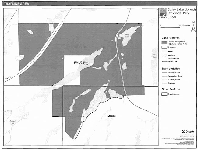
Daisy Lake Uplands Provincial Park includes portions of two trapline areas: FMU22 and FMU23 (Figure 4). Trapping is not permitted in the park. Existing commercial fur harvesting operations will be phased out by December 31, 2009. New operations, including trap cabins and trails, will not be permitted (OMNR 2000; 2003).
5.1.5 Adjacent land
Conservation reserves
The conservation reserve (CR) network complements the provincial park system by protecting representative natural areas and special landscapes. Three CRs are located near Daisy Lake Uplands Provincial Park: Tilton Forest CR, Eden Township Forest CR, and Garson Forest CR.
Tilton Forest Conservation Reserve (C210): This site is mainly covered by hardwood forests. Red maple, red oak, and scattered red pine are the main tree species in this forest. The land use intent of this area is to protect the natural heritage values of the CR.
Eden Township Forest (C157): This CR contains a red pine and cedar forest on a landscape of low hills. This site protects the best example of this vegetation/landform complex in the area. The land use intent of the CR is to protect the natural heritage values of the forest.
Garson Forest (C177): This CR protects young birch and poplar stands on top of a flat lacustrine deposit. The land use intent of this site is to protect the natural heritage values of CR.
Enhanced management area
The Killarney East Area Enhanced Management Area is located to the south-east of Daisy Lake Uplands Provincial Park. Part of the Killarney Signature Site, this large remote area contains tourism lakes, a white pine forest, and several moose wintering areas. Due to the logging roads in the area, moose and fish populations have been overharvested in some areas. Fish and wildlife management, as well as forest management, will dominate the land use activities of this enhanced management area in order to ensure that the fish and wildlife resources, as well as recreation and remote tourism opportunities, are available in perpetuity.
General use areas
Two general use areas abut Daisy Lake Uplands Provincial Park: Moose Mountain / Worthington / Coniston General Use Area (G2053) and Nepewassi I Trout Lake General Use Area (G2045).
Figure 3: Bear Management Areas

Figure 4: Trapline areas
Moose Mountain / Worthington / Coniston General Use Area (G2053): This area is dominated by mineral exploration and development; timber harvesting and aggregate extraction are other important uses. Most of the area is privately owned by industry or individuals, and the transportation networks of the City of Great Sudbury branch out into this area. In addition to human settlement and industrial land uses, the area supports two lake trout lakes and a deer wintering yard.
Nepewassi / Trout Lake General Use Area (G2045): This area, locally known as the West Arm of Lake Nipissing, extends to the east of the Wanapitei River. The primary uses of the area are timber harvesting, mineral exploration and development, aggregate extraction, fish and wildlife management, and general recreation.
Forestry
Land adjacent to the park is within the Sudbury Forest Management Unit (MU) 889. This MU is currently managed by Vermillion Forest Management Company Ltd, and is licensed by MNR to harvest timber on Crown land (Vermilion Forest Management Company Ltd., 2003). The current management plan is scheduled for renewal in 2010 (OMNR 2006).
5.1.6 Land disposition
New land disposition for the private use of individuals or corporations will not be permitted (OMNR 1992; 2000).
Land use permits. licenses of occupation, and unauthorized occupations
There are no land use permits (LUP), licenses of occupation, or known unauthorized occupations within Daisy Lake Uplands Provincial Park.
Patent land
Daisy Lake Uplands Provincial Park patent land on the north, east, north-west, and south-east sides. A parcel of Crown land abuts the park in Dill Township on the south eastern corner of the boundary. The south-west portion of the park abuts the Ministry of Transportation (MTO) corridor for the Highway 69 expansion project.
There are patent lands surrounded by the park that are owned by the City of Greater Sudbury. MNR will hold discussions with the City of Greater Sudbury regarding the long term use of this patent land.
Private land is not part of the park and, as such, park policy does not apply to these areas.
Boat caches
There are no authorized boat caches within Daisy Lake Uplands Provincial Park. Boats are not permitted to be left unattended in the park without written permission from the superintendent under the authority of the Provincial Parks Act.
5.1.7 Access and crossings
Access
Daisy Lake Uplands Provincial Park is accessible by land and water. Highway 17 passes through western side of the park, affording access by foot. The park can be accessed by canoe via Richard Lake, which is located to the south of the park.
Roads
The Highway 17 corridor bisects the park on the north-western side. The highway corridor is not included in the park boundary. There are no other roads which provide access to the park. One tertiary road is adjacent to the northwest corner of the park, but does not enter the park boundary.
Utility corridors
There are no utility corridors within the park.
All public utilities (e.g., gas pipelines, transmission lines, communications towers) must avoid park lands wherever possible. New utility corridor crossings may be necessary to maintain essential public services (OMNR 2004a).
Any future utility corridors proposed through the park, where park lands are unavoidable, will be reviewed on a case-by-case basis. Protection of park features and values will be priority and all requirements of the Environmental Assessment Act will be met.
Railway
A CPR railway line passes through the eastern portion of the park. This railway line is excluded from the park boundary.
Recreational trails
There are no authorized trails within the Daisy Lake Uplands Provincial Park. New trails (e.g. hiking) may be developed if the need arises (OMNR 2004a). Any proposed development within the park is subject to Environmental Assessment Act requirements.
Unauthorized snowmobile and all-terrain vehicle (ATV) use may occur in this area. Future management planning will review all uses, including snowmobile and ATV use, to ensure that park features and values are protected, and to assess the potential for these uses to conflict with park values and other uses. Off-trail ATV and snowmobile use is not permitted.
5.2 Aquatic ecosystems
Sustaining quality water resources is integral to the protection of park and adjacent land values. The MOE enforces applicable legislation and regulations for water quality.
5.2.1 Water management
There are no hydro developments, water control structures, or diversions within the park. New commercial hydroelectric developments will not be permitted (OMNR 2000).
Fisheries management
Fisheries management will complement the maintenance and enhancement of native, selfsustaining fish populations (OMNR 1992).
Sport fishing
Sport fishing is permitted within the Daisy Lake Uplands Provincial Park. This activity is governed by legislation and regulations in the Fish and Wildlife Conservation Act and the Fisheries Act (1985). The Recreational Fishing Regulations Summary contains details on the applicable regulations for this area.
Commercial baitfish harvesting
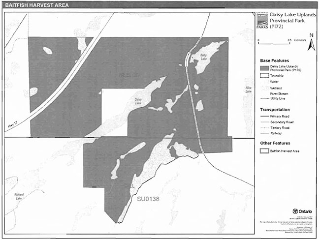
Portions of two baitfish harvesting areas are within Daisy Lake Uplands Provincial Park: SU0119 and SU0138 (Figure 5). Existing commercial baitfish harvesting within waterbodies that are enclosed by the park will be phased out by December 31, 2009. New baitfish licenses will not be permitted (OMNR 2000; 2003).
Fish stocking
Fish stocking is not permitted in Daisy Lake Uplands Provincial Park (OMNR 1992).
Figure 5: Baltfish Harvesting Areas
6.0 Operations policies
6.1 Recreation management
Future planning, with full public consultation, will review direction on motorized and non-motorized recreation uses.
6.1.1 Motorized recreation
Motorboats
The use of motorboats is not permitted in Daisy Lake Uplands Provincial Park (OMNR 1992).
Aircraft
Aircraft landings are not permitted in the park (OMNR 1992).
Snowmobiles
The use of snowmobiles is not permitted in Daisy Lake Uplands Provincial Park. Off-trail snowmobile use is not permitted within the park. New snowmobile trails are not permitted.
All-Terrain vehicles
There are no authorized ATV trails within the park boundary. Off-road use of ATVs will not be permitted within the park. New ATV trails will not be established.
6.1.2 Non-motorized recreation
Camping
Camping is not permitted in Daisy Lake Uplands Provincial Park.
Hiking
There are no authorized hiking trails within the boundaries of this provincial park. Unauthorized hiking trails and other non-mechanized trails may be permitted to continue unless such trails threaten park features and values, create user conflicts or raise safety and/or liability issues.
If there is an identified need, the development of new hiking trails may be considered. Trail infrastructure to protect park values and features may be permitted. Any proposed development within the park is subject to Environmental Assessment Act requirements.
Canoeing/Kayaking
The park is not on a canoe route. Canoeing or kayaking may be permitted to continue, unless park features and values are threatened.
6.1.3 Emerging recreational uses
There are emerging recreational uses for which there is limited or no policy to deal with their management (e.g., adventure racing and geocaching). The park superintendent will use legislation, policy, and guidelines which are in place to manage emerging uses in the interim.
6.2 Development
There is no existing development within the park. Infrastructure to protect park features and values may be permitted and developed in response to use, environmental deterioration, and environmental protection requirements. Any proposed development within the park is subject to the Environmental Assessment Act.
6.3 Commercial tourism
New commercial tourism facilities are not permitted in Daisy Lake Uplands Provincial Park.
7.0 Cultural resources
An assessment of the cultural resources specific to the park has not yet been completed. The management of any cultural values within this park will be directed toward protection and heritage appreciation (OMNR 1992).
8.0 Heritage education
Literature and other supporting information may be developed to describe the park in the context of Ontario’s provincial park system. Boundary limits, significant heritage features and permitted uses of the may be included in park literature.
Prospective park visitors may be informed about the sensitivity and significance of park values through park literature.
9.0 Research
Daisy Lake Uplands Provincial Park is currently the site of long-term monitoring studies examining natural recovery of acid-metal contaminated landscapes, and the effect of watershed liming on surface water quality (Morris 2000).
Scientific research by qualified individuals which contributes to the knowledge of natural or cultural history, or to environmental or recreational management, may be encouraged in the park. Ontario Parks will encourage institutions, such as universities, to undertake research projects.
All research programs will require the approval of Ontario Parks and are subject to park policy and other applicable legislation. Any materials removed from the park will remain the property of Ontario Parks.
Approved research activities and facilities will be compatible with the park’s protection objective. Any site which is affected by research will be rehabilitated as closely as possible to its original state. Environmental Assessment Act requirements will apply.
10.0 References
EnvironmentalAssessment Act, 1990.
Fish and Wildlife Conservation Act, 1997.
Fisheries Act, 1985.
Morris, E.R., 2000. Natural Heritage Area- Life Science Checksheet: Daisy Lake Uplands (OLL F172).
Ontario Federation of Snowmobile Clubs, 2007. Ontario Federation of Snowmobile Clubs: Trail Guide. Online. Accessed January 18, 2007. http://www.ofsc.on.caffraiiGuideffraiiGuide.asp
Ontario Ministry of Natural Resources, 1974. A Topical Organization of Ontario History. Historic Sites Branch Division of Parks.
Ontario Ministry of Natural Resources, 1992. Ontario Provincial Parks Planning and Management Policies. 1992 Update.
Ontario Ministry of Natural Resources, 1999. Ontario’s Living Legacy Land Use Strategy. July 1999. Queen’s Printer for Ontario.
Ontario Ministry of Natural Resources, 2000. Ontario’s Living Legacy Land Use Strategy (Policy Clarification).
Ontario Ministry of Natural Resources (OMNR), 2003. Directions for Commercial Resource Use Activities in Provincial Parks and Conservation Reserves. 5 pp.
Ontario Ministry of Natural Resources, 2004a. Crown Land Use Policy Atlas.
Ontario Ministry of Natural Resources (OMNR), 2004b. Forest Fire Management Strategy for Ontario.
Ontario Ministry of Natural Resources (OMNR), 2005. A Class Environmental Assessment for Provincial Parks and Conservation Reserves.
Ontario Ministry of Natural Resources, 2006. List of Forest Management Units (MU) in Ontario (2006-2007). Online. Accessed January 18, 2007.http://ontariosforests.mnr.gov.on.ca/spectrasitesNiewers/showArticle.cfm?id=C74F7704-68C7-41A6-8D96FB6079073782&method=DISPLAYFULLNOBARNOTITLE_R&ObjectlD=C74F7704-68C7-41A6-8096FB6079073782&1ang=FR&Iang=EN&Iang=FR&Iang=EN##
Provincial Parks Act, 1990.
Vermilion Forest Management Company Ltd., 2003. Sudbury Forest. Online. Accessed January 18, 2007. http:sudburyforest.com/index.htm
Appendix A: background information
| Name | Daisy lake uplands provincial park (P172) |
|---|---|
| Classification | Nature reserve |
| Ecoregion/Ecodistrict | 5E / 5E-4 |
| OMNR administrative region/district | Northeast region - Sudbury district |
| Total area (ha) | 600 |
| Regulation date and number | June 2006 (O. Reg. 331/06) |
Representation
Earth Science: The boundary between the Southern Province and the Grenville Province, two major geological provinces, passes through the south end of the park. In addition, a major fault runs underneath Daisy and Baby lakes. The bedrock was folded and partially metamorphosed 1.8 to 1.6 billion years ago during in a mountain building period (Morris 2000).
There are currently no reports describing the earth science features of the park.
Life Science: The park is representative of the Sudbury landscape which has been disturbed by more than 100 years of forestry, prospecting, mining and smelting, and urbanization. The intent is to leave the park to naturally respond without artificially accelerating the recovery process, as has been done in much of the Sudbury region. Early successional forest dominates the area with open White Birch woodlands on bedrock. Metal-tolerant ecotypes of several grass (Agrostis hyemalis, A. scabra, Deschampsia cespitosa) and sedge (Carex scoparia) species grow here. Scattered Red Maple, Red Oak, White Pine, White Cedar, and Eastern Hemlock, occur here as well. These tree species were among the most severely affected by smelter emissions and metal contaminated soils. These relict trees may be relatively metal-tolerant. There are pockets of Trembling Aspen, where soil is deeper and acid-metal contamination less severe. There is a great deal of physical relief in the park, which creates the potential for additional microhabitats (Morris 2000).
Intense historical disturbance drastically reduced the biological diversity of the Sudbury landscape. Much of the park is within the ultimate headwater of the Whitefish River; however a large proportion also drains into the Wanapitei River via Baby (within park) and Alice Lake (east of the park). The metal tolerant grass, sedge, intermixed with early successional tree species are of considerable interest to academics studying plant physiology and mineral nutrition of plants, as well as applied biologists looking to use or develop metal tolerant strains of native species for land reclamation in boreal and sub-boreal forest regions (Morris 2000).
Cultural Resources: There are currently no reports describing the cultural heritage of the park.
Recreation: There are currently no reports describing the recreational features of the park; however, the park’s landscape provides the potential for a variety of low-impact recreational pursuits to occur, including canoeing, hiking, fishing, nature appreciation, and exploring.
Inventories
| Survey level | Earth science | Life science | Culture | Recreational |
|---|---|---|---|---|
| Reconnaissance | Morris 2000 |