Devil’s Glen Provincial Park Management Plan
This document provides direction on the management of Devil’s Glen Provincial Park.
September 12, 1994
Regional director’s approval statement
I am pleased to approve the Devil’s Glen Provincial Park Management Plan Amendment.
This document is to be used in conjunction with the 1989 Park Management Plan, as official policy for the development and management of Devil’s Glen Provincial Park.
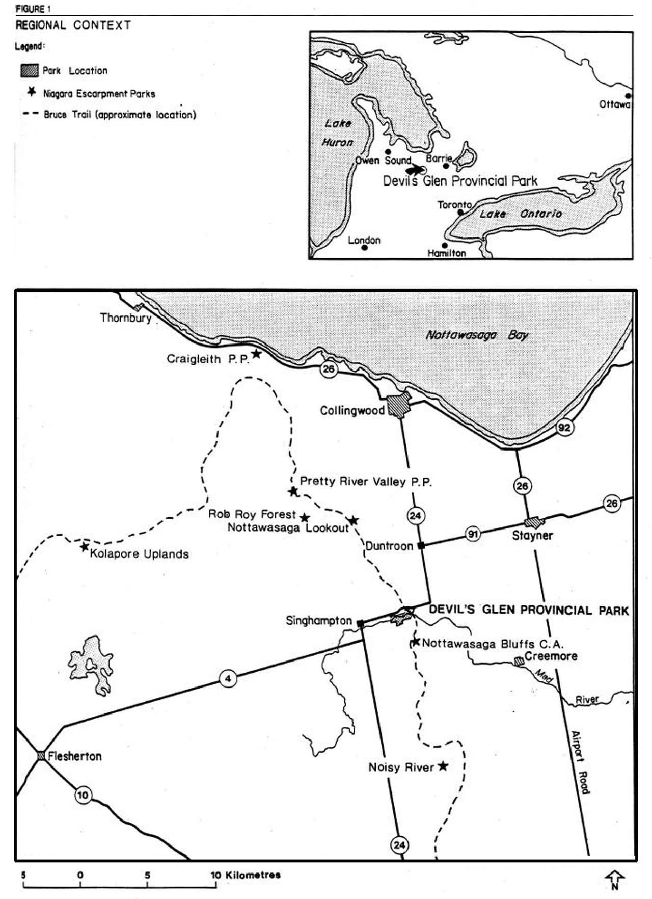
Figure 1: Regional context map
1.0. Introduction
The Devil’s Glen Provincial Park Management Plan was approved and released in 1989. Given a lifespan of ten years, a plan review would not normally have been scheduled until after 1999. However, during the term of the existing management plan, circumstances changed which required the plan to be amended. This amendment to the park management plan permits changes which do not miter the overall Intent of the plan (i.e. changes which are consistent with the park’s classification, goal and objectives but differ from the park’s management policy statements). The changes to the management plan constitutes a major amendment that would affect park users.
The amendment to the management plan pertains primarily to the permanent closure and retirement of the campground and related facilities In Devil’s Glen Provincial Park. Day use opportunities will not be affected by this plan amendment.
2.0 Plan amendment
2.1 Campground closure and retirement
As part of its expenditure control plan, the Ministry of Natural Resources closed the campground and related facilities for the 1994 operating season. This amendment now authorizes the permanent closure and retirement of the campground facilities. The park will continue to be open for day use on a seasonal basis, offering opportunities such as hiking, nature appreciation and sport fishing.
A phased retirement of campground facilities will occur over a two year period and may Involve most, or all of the following:
Disconnection of services
- hydro, water, telephone
Removal and disposal of structures
- vault privies with exception of one unit
- maintenance/storage building
- administrative building/gatehouse
- pump house
- woodyard
- creative playground
Removal and disposal of equipment
- campsite posts and fireplaces
- picnic tables (except for picnicking)
Salvageable park structures and equipment will be redirected to other area provincial parks or disposed of by other appropriate means.
3.0 Objectives
The focus of the recreation objective for Devil’s Glen will now be day use only, with the sole exception of remaining as an overnight rest area for Bruce Trail hikers.
The protection objective for the park’s significant natural values continues to be a high priority.
The management plan amendment process satisfied the requirement for a concurrent amendment of the Midhurst District Land Use Guidelines (1983) which will adjust the park/zone/district camping opportunity targets.
4.0 Operations policies
-
- The information component of the park’s visitor services program will continue to be achieved through the use of signs, publications and Interpretive panels. Personal contact with day users will occur on an Informal and infrequent basis.
-
Devil’s Glen will continue to offer day use opportunities for hiking, sports fishing and nature appreciation. The park will also continue to serve as a Bruce Trail access point and as an overnight rest area for hikers, with restrictions on party size and duration of stay to be monitored and established by the Park Superintendent.
Group camping and vehicle camping opportunities will not be offered at this park. During the 1995 operating season only, transient campers will be redirected to other provincial, conservation authority or private campground facilities in the area, by appropriate means.
5.0 Resource management policies
-
-
Grass cutting will be confined to the high use areas of the park such as around picnic areas, parking areas and the washroom.
The former campground area may be rehabilitated by random planting of native trees and shrubs. This may be addressed as part of a detailed vegetation management strategy for the park, or as a separate planting plan for this area.
-
6.0 Summary of public consultation
Public consultation for the Devil’s Glen Provincial Park Management Plan Amendment was primarily focused on the local area.
The 1994 Ontario Provincial Parks Guide listed Devil’s Glen Provincial Park as ’day use only’. This listing will be repeated in future editions.
A mailing list was prepared consisting of local interest groups, municipalities, government agencies, provincial and federal members of parliament and adjacent landowners. Over 50 copies of the preliminary plan amendment were distributed following March 21, 1994. Additional copies were provided upon request.
A news release was also distributed to local media outlets the week of March 21, 1994. A paid newspaper advertisement was placed in four area newspapers during the first week of April, 1994.
On May 3, 1994, over 500 letters were mailed out to Devil’s Glen Provincial Park 1993 camping patrons advising them of the campground closure for the 1994 season.
In early May of 1994, Devil’s Glen was included in an announcement that, as part of its expenditure control plan, MNR would not be reopening eight provincial parks in 1994. The decision was slightly modified for Devil’s Glen to allow normal day use opportunities. This decision was made after the original plan to close the campground.
Notices concerning the proposed plan amendment were posted at both Devil’s Glen and Wasaga Beach Provincial Parks from the Victoria Day weekend through to the Labour Day weekend, 1994.
Staff at Wasaga Beach Provincial Park answered a limited number of (telephone and mail-in) campsite reservation requests for the 1994 season. Campers were advised the campground was closed and were redirected to other campgrounds in the vicinity.
The official due date for responses to the proposed plan amendment was May 27, 1994, however, responses were entertained until Labour Day.
The results of the various consultation-communications efforts included four media interviews, six letters, and six telephone responses. Public comments were summarized and analyzed and incorporated into the final management plan amendment, where appropriate.
Based upon both Ministry of Natural Resources’ staff discussions and external Input, the final Devil’s Glen Provincial Park Management Plan Amendment was approved in early September, 1994. Following this, copies were distributed to a revised contact list. Additional copies of this document will be made available upon request.
Issues raised
A number of local business operators and local residents objected to the closure and retirement of the campground. Some respondents suggested operational alternatives, such as contracting, hiring students, et cetera, as a means of operating the campground more efficiently (measures which the Ministry had previously implemented).
There was support for continued protection of the park’s significant earth and life science features and provision for day use opportunities.
Some concerns were expressed that the level of park maintenance would suffer and that vandalism would be a problem if the campground were to be dosed.
The Bruce Trail Association had no objection to the plan amendment but did support retention of an overnight camping facility for hikers.
The Niagara Escarpment Commission had no objection to the plan amendment but did propose a change in park classification from "recreation" to "natural environment".
Park patrons did not express concern over the campground closure.
Devil’s Glen Provincial Park Management Plan
ISBN 0— 7729—5686— 3
©1989, Queen’s Printer for Ontario Printed in Ontario, Canada
Single copies of this publication are available at no charge from the address noted below. Bulk orders may involve charges.
Ontario Ministry of Natural Resources
Huronia District Office
Midhurst, Ontario
L0L 1X0
We are pleased to approve the Devil’s Glen Provincial Park Management Plan, as official policy for the management and development of this park. The plan reflects this Ministry’s Intent to protect the natural features of the park and maintain and develop high quality opportunities for outdoor recreation and heritage appreciation for both residents of Ontario and visitors to the Province.
A. S. Holder
Regional Director
Central Region
N. Richards
Director Parks and Recreational Areas Branch
1. Introduction
Devil’s Glen Provincial Park is a small park situated on the Niagara Escarpment, south of Nottawasaga Bay, in the Township of Nottawasaga, County of Simcoe. The park is located approximately 16 km south of Collingwood, and 24 km southwest of Wasaga Beach (see Figure 1).
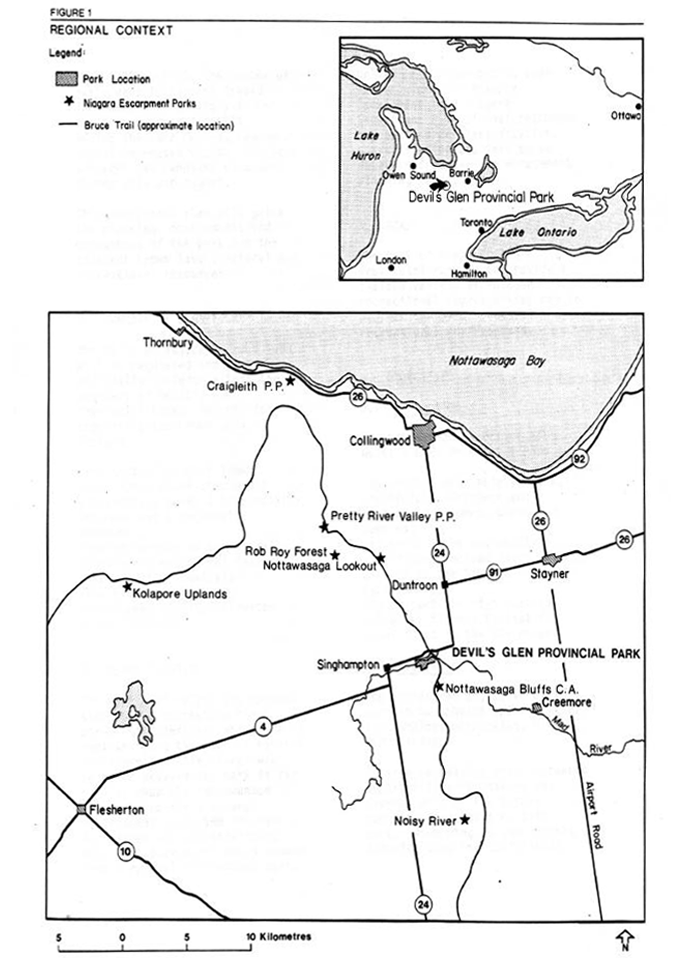
The park has an upland land base of 5.5 ha which includes 45 campsites and a small day— use picnic area (approximately 10 tables). Adjacent to Devil’s Glen is 55 ha of Crown land (see Figure 2) consisting primarily of a steep—sided valley where the Mad River has cut through the Niagara Escarpment and left Silurian Amabel dolomite rock exposed. The park’s 2.5 km hiking trail is located in this valley and is part of the Blue Mountain Section of the Bruce Trail. The Ganaraska Hiking Trail joins the Bruce Trail just to the southeast of the park.
No additional camping or picnicking facilities are proposed since the remaining park land and most of the Crown land is too steep and fragile to be suitable for further development.
The park and the Crown land possess the following natural characteristics: rock faces and outcrop features, slopes 12~ or greater, bottomlands, wetlands, the Mad River (quality coldwater fishery habitat), natural vegetative cover, wildlife habitat areas, and viewing vantage points along the rim of the valley.
The park is one of 105 existing and proposed parks located in the Niagara Escarpment Parks System.
This system is based on public lands acquired to protect distinctive features and areas along the Escarpment. The system consists of lands owned and managed by several agencies. The Ministry of Natural Resources is the predominant manager of Escarpment parks in the area.
Pretty River Valley Provincial Park, 10 km to the northwest of Devil’s Glen, has been designated as a nodal park with a distinctive role to play within the Niagara Escarpment Parks System. When Pretty River Valley Provincial Park is developed it will be a key staging area and interpretive centre for this segment of the Escarpment and the major starting place from which to explore other nearby parks, including Devil’s Glen.
The Bruce Trail, which goes through Devil’s Glen, is an essential component of the system, linking the park to other public open spaces and scenic attractions along the Escarpment’s 725 kilometres.
Devil’s Glen fits in with the intention of the Niagara Escarpment Parks System by providing extensive recreational experiences (hiking, etc.) with limited development for activities such as picnicking and camping. Recreational opportunities and the provision of facilities (i.e., camping) at Devil ’s Glen may be re-evaluated in the future as other Niagara Escarpment Parks are developed in the area.
From 1980 to 1985, the number of daily vehicle permits issued increased approximately 4% and visitors increased by 10%. During the same period, camper nights increased 27.5%. The park averages 44% campsite occupancy during July and August.
This management plan will guide the planning, development and management of the park and the adjacent Crown land’s natural and recreational resources.
Figure 1: Regional context map
2. Summary of significant issues
The 55 ha of adjacent Crown land will be regulated and thus officially included within the boundary of Devil’s Glen Provincial Park. Reasons for regulating the Crown land include:
- the protection of 5 known significant plant species (1 provincially rare, 3 provincially uncommon and 1 regionally uncommon);
- the protection of a regionally significant geological feature (incised river valley);
- the protection of a significant quality coldwater fishery habitat.
3. Classification
The park will retain its current status as a recreation class park. Consideration was given to reclassifying the park as natural environment. This change was rejected because the park is far smaller than the recommended minimum size for a natural environment park, and the park’s facilities are not consistent with what park users would expect from a natural environment park.
Unlike most other public open spaces along the Niagara Escarpment, the Niagara Escarpment Plan did not recommend any particular classification. Classification was left to be determined during the management planning process.
4. Goal
The goal of Devil’s Glen Provincial Park is to provide a limited variety of outdoor recreational opportunities and to protect the park’s natural and recreational environments.
5. Objectives
5.1 Protection
The protection objective of Devil’s Glen Provincial Park is:
- to protect provincially rare, provincially uncommon and regionally uncommon plant species;
- to protect the regionally significant incised river valley, as well as the Niagara Escarpment;
- to protect the high quality coldwater fishery habitat for brook trout in the Mad River.
5.2 Recreation
The recreation objective of this park is to provide opportunities for camping, picnicking, hiking and fishing.
Passive recreation with increased opportunities for hiking and fishing will be the future recreation emphasis of this park. According to the Huronia District Land Use Guidelines:
- the park’s 45 campsites are estimated to represent .7% of the camping opportunities in the district to the year 2000 (the park presently offers .9% of these opportunities);
- the park’s 10 day—use picnic tables are estimated to represent .1% of the picnicking opportunities in the district to the year 2000 (the park presently offers .2% of these opportunities).
(N.B.) The difference in camping and picnicking percentile opportunities between present day and the year 2000, represents an estimated increase in the number of similar opportunities to be made available elsewhere and does not reflect any proposed decrease in facility—based opportunities at Devil’s Glen.
5.3 Heritage appreciation
The heritage appreciation objective of this park is to provide facilities that will enable park visitors to explore, interpret and appreciate the landscape units and the life science and earth science values of the park and the adjacent portions of the Niagara Escarpment.
5.4 Tourism
The tourism objective for this park is to provide Ontario residents and out-of— province visitors with opportunities to discover and experience the Niagara Escarpment, Bruce Trail and surrounding recreational attractions in the Blue Mountain and southern Nottawasaga Bay region.
The park, in 1979, contributed almost $284,000 to the provincial economy through park expenditures and tourist spending. It is the objective of the Ministry to maintain and possibly increase the economic contribution of this park to the local economy.
6. Boundary
The park boundary will be revised by placing the adjacent Crown land into regulation. The total area of the park will be approximately 61 ha.
Because portions of the park’s proposed hiking trails are sited on land owned by the Devil’s Glen Country Club, a licence or easement agreement between the Ministry and the Club may be considered for all of or part of lands, north of the river, referred to as land parcels A and B (see Figure 2).
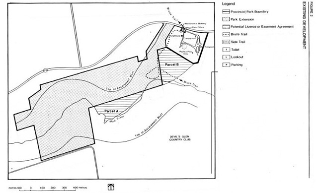
7. Zoning
All lands within the park boundary have been zoned (see Figure 3) in recognition of their environmental qualities, required protection and their potential for recreational use within the context of the objectives of the park.
7.1 Development zone
This zone (5 ha) is located on the tableland in the northeast corner of the park. Located here are camping, day use, maintenance and administrative facilities. The land base of this zone is a fully developed so little opportunity remains for any expansion of facilities.
Figure 2: Existing development map
Enlarge existing development map
Figure 3: Zoning and proposed development map
Development zone policies
- To improve the landscape aesthetics and the environmental quality of this zone through landscape plantings.
- To maximize recreational opportunities by maintaining and improving upon existing facilities as deemed necessary.
7.2 Natural environment zone
This zone (56 ha) contains the Mad River Valley as well as small upland level areas.
Natural environment zone policies
- To protect the significant natural features from detrimental forms and levels of recreational use.
- To encourage extensive forms of recreational use (e.g., hiking, nature appreciation, viewing, fishing) and to provide adequate facilities to accommodate such use while minimizing environmental impact.
- To monitor use to determine its impact on the environment and to take appropriate action if environmental degradation occurs.
8. Resource management policies
8.1 Water management
The Mad River is rated as a quality coldwater fishery habitat. Management initiatives, endorsed by the district fish and wildlife section, to maintain and improve this resource will be encouraged. The district plans to conduct a stream survey and a stream fisheries habitat assessment of the Mad River in the near future.
8.2 Vegetation management
The vegetation communities outside the development zone will be allowed to evolve on their own with little or no management. Vegetation management in the development zone requires additional plantings and maintenance of existing plants.
Forest and vegetative insects and diseases threatening values inside or outside the park will be controlled where feasible.
9. Operations policies
A Park Operations Strategy will be prepared to provide park staff with the necessary information required to operate the park on a day-to-day basis. In addition to addressing the operations policies, which follow, the strategy will include such topics as budget, staffing, and maintenance schedules, enforcement and emergency services. The provisions of the strategy will be consistent with the approved Ontario Provincial Parks Operating Standards, and will be reviewed annually and updated as required.
9.1 Visitor services
Devil’s Glen as a small provincial park, provides a limited variety of visitor services. Of the three visitor service components (information, interpretation, and recreation), the former two are emphasized at this park.
Information Objectives of this component will include the following:
- informing visitors about the park, its services, facilities and management concerns;
- informing visitors about recreation and interpretive opportunities in the local area;
- informing visitors of the role of the Ministry of Natural Resources;
- instilling a sense of respect in visitors for the park environment;
- providing a means of feedback for visitors to communicate with park management.
The objectives outlined above will be achieved through all or some of the following: publications, signs and personal contact involving campsite visitation.
Interpretation
The park contains a variety of significant and interesting features (earth and life science) worthy of interpretation. The general major theme is the Niagara Escarpment with its distinctive natural features, its park system and the Bruce Trail.
Life science
Features include a diverse range of vegetative communities some with rare and uncommon plant species. Included here is the significant trout spawning and habitat potential of the Mad River.
Earth science
The main feature here is the regionally significant incised river valley cut through the escarpment by the Mad River.
Interpretation of the above will be essentially by self— use trails in conjunction with publications and on-site low-key facilities (i.e., plaques, signs, display boards).
Construction of a viewing platform is proposed. The platform will provide an excellent view over the Mod River valley, and will have a number of plaques with interpretive messages.
9.2 Recreation management
- The park will be accessible on a year- round basis for day—use activities. Camping will only be available during the regular summer season.
- Passive recreation activities will be expanded (i.e., hiking, wildlife viewing, and fishing). There will be no further expansion of camping or picnicking facilities because the upland landbase is already developed to capacity.
- Hunting will not be allowed in the park. Sport fishing will be encouraged in the Mad River.
- Because portions of the park’s proposed hiking trails are sited on land owned by the Devil’s Glen Country Club, a licence or easement agreement between the Ministry and the Club may be considered.
- Activities compatible with the park environment and park management guidelines, will be allowed as the district parks and recreation section deems suitable.
- Use of motorized off—road recreational vehicles will not be permitted.
9.3 Tourism services
A firewood concession has been provided in the past, and could be re-established. It is unlikely that other concessions would be viable.
9.4 Marketing
A Marketing Plan, primarily aimed at attracting those types of people who would enjoy a quiet day use and/or camping experience with a limited range of recreational opportunities, will be prepared. The plan will emphasize the park’s value as a base for exploring the Niagara Escarpment.
10. Development policies
Two specific developments are recommended:
- Construction of a viewing platform with interpretive plaques. Expansion of the Mad River Hiking Trail westward to include the majority of accessible valleylands within the former Crown land area. This trail will have to be designed to avoid sensitive life/earth science features as well as to take advantage of the vistas offered along the rim of the valley.
- The park’s water supply is from an artesian well. The quality of the water will be carefully monitored. If contamination problems develop, or appear likely, an alternate water supply will be provided.
11. Summary of public consultation
Public consultation during the management planning process focused on the local area and included the following:
A news release and advertisement in the Collingwood Enterprise and Bulletin, Blue Mountain Buyers Guide and the Creemore Sun newspapers advised that the draft management plan and the background Information document were available for review at the district office;
- copies of the management plan and news release were forwarded to local levels of government for review- (Township of Nottawasaga, Simcoe County, Nottawasaga Valley Conservation Authority, Niagara Escarpment Commission);
- copies of the management plan and news release were sent to the following interest groups: Blue Mountain Club of the Bruce Trail Association, Devil’s Glen Country Club, Federation of Ontario Naturalists and the Ontario Federation of Anglers and Hunters, Coalition on the Niagara Escarpment;
- where appropriate, contact was made with adjacent landowners by park management, to inform these landowners of the plan and its contents;
- announcements and posters were on display in the park during early 1986 advising park visitors of availability of plan, at the district office, for review.
12. Plan review and amendment
This management plan will be reviewed at least once every ten years to reconfirm or revise the resource management, operations and development policies. Minor amendments may be made in the interim as required. Major amendments having broad implications for park management will receive public review.
13. References
Gould, J.; A Reconnaissance Biological Inventory of Devil ’s Glen Provincial Park and Park Reserve, 1984.
Ontario Ministry of Natural Resources; ANSI File - Devil’s Glen Up land Forest, 41A/8 610120, Central Region.
Ontario Ministry of Natural Resources; Devil’s Glen Provincial Park Management Plan, Background Information Document, 1985.
Ontario Ministry of Natural Resources; Provincial Parks in the Niagara Escarpment Planning Area: A Future Perspective.
Ontario Ministry of Natural Resources; A Summary of the Earth Science Areas of Natural and Scientific Interest In Huronia District, 1983.
Ontario Ministry of Natural Resources; Mad River - An Ecological Assessment, 1972.
Ontario Ministry of Natural Resources and Econometrics Ltd.; Economic Impact of Provincial Parks in Ontario: A Summary Report.
Ontario Ministry of Natural Resources; Ontario Provincial Parks Statistics, 1983, 1982, 1981, 1980.
Ontario Ministry of Natural Resources; Provincial Park Draft Systems Plan, Central Region, Ontario Ministry of Natural Resources; Central Reylon Ontario Provincial Parks, Visitor Services Plan.
Ontario Provincial Secretariat for Resources Development; Niagara Escarpment Plan - Volume 2 — Recommended Policies of the Provincial Secretary for Resources Development, 1984.