Duclos Point Provincial Park Management Statement
This document provides direction on the management of Duclos Point Provincial Park.
Interim Management Statement
2007
Approval statement
I am pleased to approve this Interim Management Statement for Duclos Point Provincial Park. The property was regulated under the Provincial Parks Act in February of 1985 (O. Reg. 279/85) and is managed as a nature reserve class park.
This Interim Management Statement provides direction for the protection and management of Duclos Point Provincial Park.
Signed by:
Brian Pfrimmer
Zone Manager
Central Zone, Ontario Parks
Date:
August 23, 2007
1.0 Introduction
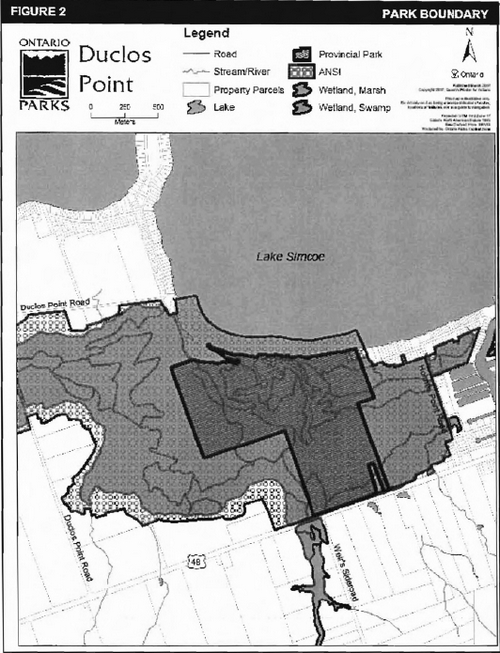
Duclos Point Provincial Nature Reserve is situated on the southern shore of Lake Simcoe, 10 km east of the town of Sutton and 4 km northwest of the town of Pefferlaw in the Town of Georgina, York Region (Figure 1). It contains a variety of provincially significant wetland community types and is part of the Duclos Point Reserve and Adjacent Lands provincially significant Life Science Area of Natural and Scientific Interest (ANSI). The park is 110 ha in size and is regulated under the Provincial Parks Act (O. Reg. 279/85) (Figure 2).
Management of Duclos Point has been guided by an Interim Management Statement (IMS), which was approved in 1986. This updated IMS will provide direction for the custodial management of park resources. Any significant decisions regarding resource stewardship, development, operations, and permitted uses will require Ontario Parks to initiate additional planning processes, including public consultation.
Duclos Point is managed as part of the Sibbald Point cluster of parks.
2.0 Classification
Ontario provincial parks are classified into one of six categories, each of which has particular purposes and characteristics.
Duclos Point is a nature reserve class park. The emphasis of nature reserves is on providing representation of and protection for Ontario’s geological, ecological and species diversity. Where compatible with park values, low intensity day-use activities are encouraged.
3.0 Objectives
Management of Duclos Point Provincial Nature Reserve will be consistent with the four objectives for provincial parks, as described in the Provincial Parks and Conservation Reserves Act, 2006 (effective September 4, 2007):
- To permanently protect representative ecosystems, biodiversity and provincially significant elements of Ontario’s natural and cultural heritage and to manage these areas to ensure that ecological integrity is maintained
- To provide opportunities for ecologically sustain-able outdoor recreation opportunities and encourage associated economic benefits
- To provide opportunities for residents of Ontario and visitors to increase their knowledge and appreciation of Ontario’s natural and cultural heritage
- To facilitate scientific research and to provide points of reference to support monitoring of eco-logical change on the broader landscape
Figure 1: Regional Context
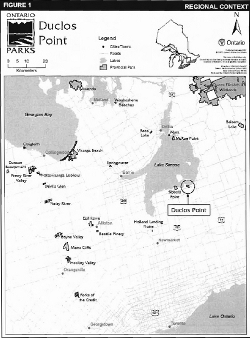
Figure 2: Park Boundary
4.0 Management context
Park management will follow direction from:
- Ontario Provincial Parks Planning and Management Policies and updates
- Provincial Parks and Conservation Reserves Act, 2006, and regulations (effective September 4, 2007).
In addressing custodial management to protect park features and values and ensure public health and safety, Ontario Parks will ensure that policy and environmental assessment requirements are implemented.
The park superintendent will implement the policies, procedures and legislation that are derived from the above direction and written into the Interim Management Statement for Duclos Point Provincial Nature Reserve.
4.1 Environmental assessment
As part of the Ministry of Natural Resources, Ontario Parks is a public sector agency subject to the provincial Environmental Assessment Act and the Canadian Environmental Assessment Act. Management of this park will be carried out in accordance with legislation, policies and the MNR Class Environmental Assessment for Provincial Parks and Conservation Reserves.
5.0 Aboriginal rights
Duclos Point Provincial Nature Reserve is not subject to any native land claims.
The Chippewas of Georgina Island First Nation is located on three islands in Lake Simcoe approximately 4 kms north west of Duclos Point Provincial Nature Reserve. The lands currently owned by the Chippewas of Georgina Island First Nation were confirmed by the Williams Treaties in 1923. The Chippewas of Georgina Island First Nation is a member of the Ogemawahj Tribal Council, which provides support in the planning and delivery of community-based initiatives of six First Nations in South Central Ontario.
Nothing in this plan shall be construed so as to abrogate or derogate from the protection provided for the existing Aboriginal or treaty rights of the Aboriginal people of Canada as recognized and affirmed in section 35 of the Constitution Act, 1982.
6.0 Boundary
The boundary of Duclos Point Provincial Nature Reserve is described in Ontario Regulation 279/85. The park is located in the northern portion of the Town of Georgina in the Regional Municipality of York. The park occupies part of Lots 18, 19 and 20, Concession 7 of Georgina Township (Figure 2).
7.0 Park features and values
Duclos Point Provincial Nature Reserve protects wetland habitats, including open marsh, swamp and two small streams, and represents a large portion of a provincially significant marsh-swamp wetland complex. The park contains a natural shoreline, sandbar and associated backshore marsh and is one of the few remaining undisturbed lake front wetland complexes on Lake Simcoe (Hanna, 1984).
7.1 Life sciences
Duclos Point Provincial Nature Reserve is located within Ecodistrict 6E-6, which encompasses most of the Lake Simcoe Basin. The park covers most of the Duclos Point Park Reserve and Adjacent Lands Life Science Area of Natural and Scientific Interest (ANSI), and includes areas of open water, shallow marsh, deep marsh, thicket swamp and deciduous and coniferous swamp forest.
Although no detailed life science inventory has been completed for the park, a general description of the vegetation communities is provided in the ANSI inventories (J. Gould, 1988). Along Lake Simcoe the offshore sand bars are sparsely vegetated with Three-square Bulrush (Schoenoplectus pungens). A young forest of Balsam Poplar (Populus balsamifera), Willow (Salix sp.), White Birch (Betula papyrifera), Red Ash (Fraxinus pennsylvanica), and Eastern White Cedar (Thuja occidentalis) is found on the low lying wet beach bar. The west and east inlet marshes support Broad-leaved Cattail (Typha latifolia), Three-square Bulrush, Wild Rice (Zizania aquatica) and Water Willow (Decodon verticillatus). These disperse into Common Reed (Phragmites australis) - Canada Blue-joint (Calamagrostis canadensis) meadow and then into extensive Alder (Alnus incana), Alder - Red Ash, Silver Maple (Acer saccharinum) - White Birch, Eastern White Cedar and Tamarack (Larix laricina) swamp (Hanna, 1981).
Wildlife typical of the area inhabit the park and it serves as foraging habitat for a variety of bird species, including Caspian Tern (Sterna caspia) and Red-shouldered Hawk (Buteo lineatus). A Great Blue Heron (Ardea herodias) nesting colony is located within the park. There are no documented occurrences of species at risk, but a detailed inventory is required to confirm the presence of several species that may potentially occur in the reserve.
7.2 Earth sciences
The local bedrock consists of Mid-Ordovician limestone and shale belonging to the Trenton and Black River Groups (Coates, 1973). Glacial Lake Algonquin covered all of the present Lake Simcoe as well as a large area south of the contemporary shoreline, depositing glacio-lacustrine sediments of gravel, sand, silt and clay. A low, sandy, poorly drained plain covers most of Georgina Township, interspersed with some higher areas of drumlinized till, which would have been islands in glacial Lake Algonquin (Chapman & Putnam, 1984). Additionally, peat deposits up to 7.5 m underlay Duclos Point Provincial Park. (Coates, 1973). The northern edge of the site consists of a deep beach deposit and two spits which form the east and west inlets.
7.3 Cultural features
There is evidence that this area was a significant aboriginal site that was used as a camping and hunting ground for the Chippewas of Georgina Island First Nation. Earlier aboriginals had lived in the area in and around Duclos Point and artefacts and burial grounds have been discovered in the nearby area (Coates, 1973). There are no reports which document cultural features within Duclos Point Provincial Nature Reserve.
Future planning will use the provincial framework, The Topical Organization of Ontario History as well as updates and discussions with other agencies, First Nations, and interest groups to identify cultural heritage values and features within the park. This information may be used to develop management guidelines to conserve and protect representative archaeological and historical values and features, as well as provide direction for further research.
8.0 Stewardship policies
An adaptive management approach will be applied to resource management activities within Duclos Point Provincial Nature Reserve. Adaptive management allows for frequent modification of management practices and policies based on the outcome of operational programs.
8.1 Industrial/commercial uses
The following uses are not permitted in Duclos Point Provincial Nature Reserve:
- commercial forestry
- commercial tourism
- commercial fishing or baitfish harvesting
- trapping
- prospecting, staking mining claims, developing mineral interests, working mines
- extraction of sand, gravel, topsoil or peat
- commercial hydroelectric power development
- fuel wood cutting
- timber salvage and sunken log retrieval
- commercial harvesting of non-timber forest products (e.g. wild rice, Canada yew, etc.)
Aboriginals exercising treaty rights are permitted to continue commercial fur harvesting in all parks, subject to applicable legislation and regulation.
8.2 Land management
8.2.1 Access and crossings
By land, Duclos Point Provincial Nature Reserve is accessed from Highway 48. The access point to the park is located between Holme’s Point Road and Weir’s Sideroad, on the north side of highway 48. The park does not host any parking or staging areas, and may only be accessed by pedestrians from the road. There is a 1 km long, unopened access road that enters the park, however, it is often flooded and therefore impassable. An entrance gate restricts vehicular access on this road. No new road development will be permitted.
Visitors also frequently access the park and adjacent wet beach by watercraft from Lake Simcoe. In summer months in particular, large numbers of boats are often moored off the park shoreline to facilitate recreation activities such as swimming and picnicking. Care will need to be taken to ensure that these activities do not adversely impact the natural values of the reserve.
There are no utility corridors located within the boundary of the park. Any future utility corridors (e.g. gas pipelines, transmission lines, communications towers, etc.) proposed through the park, where park lands are unavoidable, will be reviewed on a case-by-case basis.
8.2.2 Land use/adjacent land management
There are no land use permits issued for the park. There are no known unauthorized occupations within Duclos Point Provincial Nature Reserve. No new land use permits or licences of occupation will be granted.
The lands adjacent to the park to the south, east and west are private and are rural residential, residential or vacant. There is a public school located adjacent to the southwest boundary of the park.
8.2.3 Land acquisition
Ontario Parks will support the acquisition of property for the purposes of addition to the park, if acquisition will enhance the values of the park. Acquisition or securement will be subject to funding and willingness of the owners to sell or lease their properties or enter into a conservation easement.
8.3 Water management
Sustaining high quality water resources is fundamental to the protection of park and adjacent land features and values. The Ontario Ministry of the Environment enforces applicable legislation and regulations pertaining to water quality.
The park is located on the shore of Lake Simcoe and protects an area of shoreline wetlands, streams and two small inlets. The water levels of Lake Simcoe are controlled by the regulation of the Trent-Severn Waterway, which is managed by the Parks Canada Agency.
There are no dams, water control structures, or diversions within the park boundaries.
8.4 Non-native and invasive species
Where possible, actions will be taken to eliminate or reduce the threat of invasive and non-native species which may be affecting the diversity of naturally occurring populations. Where non-native species are already established and threaten natural or cultural values, a program of control may be undertaken if feasible and practical. Non-native species are species not native to Ontario or are species native to Ontario but not to the park. Non-native species will not be deliberately introduced. Invasive species are species that are likely to spread and negatively affect native ecosystems.
8.5 Forest fire management
Fire management in Ontario is based upon a division of the province by management objectives, land use, fire load, and forest ecology. Duclos Point Provincial Nature Reserve is located within the Southern Ontario Fire Management Zone. In accordance with existing provincial park policy and the Forest Fire Management Strategy for Ontario, forest fire protection will be carried out in Duclos Point Provincial Nature Reserve as on surrounding lands. Natural and human caused fires will be suppressed. Any prescribed fire management may be permitted by prescription and in a controlled setting. In the Southern Ontario Zone, municipalities have the lead in fire protection and management activities, under the Fire Protection and Prevention Act (FPPA) and through municipal by-laws. The local fire department is the first emergency response through 9-1-1.
8.6 Vegetation
Insects and diseases may be managed where the aesthetic, cultural, and/or natural features and values of Duclos Point Provincial Nature Reserve are threatened. Control will follow guidelines established by the Ontario Ministry of the Environment and the Ontario Ministry of Natural Resources. Whenever possible, biological controls will be given preference over the use of chemicals.
8.7 Wildlife
Removal and/or harassment of non-game animals is not permitted in provincial parks (Provincial Parks and Conservation Reserves Act, 2006, (effective September 4, 2007)). Hunting and commercial fur harvesting are not permitted in the nature reserve.
Waterfowl hunting occurs in the fall from Lake Simcoe water blinds adjacent to the Duclos Point Provincial Nature Reserve. Access is generally via the water from a private campground along Duclos Point Road. Occasional occurrences of unauthorized land-based hunting in the reserve will continue to be addressed by MNR Conservation Officers and Ontario Parks staff.
Occasionally, animals may pose a threat to public safety, or to park facilities. Wildlife management may be undertaken on an as required basis in order to protect health and safety of park visitors and park staff, or to protect park facilities. The removal of nuisance animals will be undertaken by, or under the supervision of the park superintendent.
8.8 Fisheries
The Lake Simcoe fishery is managed by the Ministry of Natural Resources. Lake Simcoe contains a variety of sport fish species including lake whitefish, northern pike, yellow perch, smallmouth bass, and largemouth bass. There is some indication that the shoreline of the Duclos Point Provincial Nature Reserve is used as a spawning area by yellow perch, and that the creek within the park functions as a spawning area for northern pike. The shoreline adjacent to the reserve has been identified through the Lake Simcoe Muskellunge Restoration program as providing good nursery habitat and has been selected for stocking.
Sport fishing is permitted within Duclos Point Provincial Nature Reserve. Any sport fishing activity is governed by the legislation and regulations in the Fish and Wildlife Conservation Act (1997), as well as the Federal Fisheries Act (1985). The Recreational Fishing Regulations Summary (Fisheries Management Zone 16) contains details regarding general regulations and exceptions to these regulations for the area of Duclos Point Provincial Nature Reserve.
Commercial Fishing and Commercial Baitfishing occur on Lake Simcoe. Registered bait harvesting licences in the vicinity of the park are numbered AU-0106 (the park) and AU-0013 (Lake Simcoe). Commercial fishing and Baitfishing are not allowed in Duclos Point Provincial Nature Reserve.
8.9 Cultural resources
An assessment of the cultural resources specific to Duclos Point Provincial Nature Reserve has not been completed at this time, however upon completion, management of any cultural features and values within this park will be directed toward protection and heritage appreciation.
8.10 Research
Scientific research by qualified individuals contributing to the knowledge of natural and cultural history and to environmental management will be encouraged. All research will be conducted by, or authorized by, Ontario Parks. Research projects will be administered through park policy directive and will require a research permit. Research must also meet all requirements under applicable provincial and federal legislation. Approved research and monitoring activities must be consistent with Ontario Parks' Research and Information Strategy (1997). Temporary facilities in support of approved research and monitoring activities may be considered. The collection of fossils, rocks, minerals, archaeological/cultural artefacts, plants, seeds and bioprospecting may be permitted by research permit and/or scientific collector permit.
Approved research activities and facilities will be compatible with protection values and/or recreational uses in the park, and will be subject to development and management policies associated with the park’s classification unless special permission is given. Sites altered by research activities will be rehabilitated as closely to their previous condition as possible.
9.0 Operations policies
9.1 Recreation management
Duclos Point Provincial Nature Reserve offers excellent wildlife viewing opportunities. Passive nature appreciation and low-impact recreational activities are encouraged in nature reserve class parks.
Motorized and non-motorized vehicles are not permitted in the park. This includes, but is not limited to: motor vehicles, trailers, snowmobiles, all terrain vehicles, and other off-road vehicles. The use of motorized vehicles may occasionally be used for park maintenance or monitoring under the authority of the Park Superintendent.
Motorboats are permitted on the waters of Lake Simcoe.
Under the policies outlined for nature reserve class parks, camping, mountain biking and horseback riding are not permitted. Open fires are prohibited. Unauthorized hiking trails and other non-mechanized trails that are documented at the time of the approval of the Interim Management Statement will be reviewed. The park superintendent may discontinue existing unauthorized trails if it is determined that such trails threaten park features and values, create user conflicts or raise safety and/or liability issues.
If there is an identified need, the development of new trails may be considered in future planning. Any proposed development within Duclos Point Provincial Nature Reserve is subject to OMNR Environmental Assessment requirements.
9.1.1 Emerging recreation uses
Adventure racing is not permitted. Geocaching may be permitted at the discretion of the Park Superintendent.
There are emerging recreation uses for which there is no or limited policy to deal with their management. The Park Superintendent will use legislation, park policy and guidelines that are in place in the interim to manage emerging uses. The Park Superintendent will also work with the OMNR Aurora District Office to manage these emerging uses.
9.2 Heritage education
Basic literature and supporting information may be developed to describe Duclos Point Provincial Nature Reserve in the context of Ontario’s provincial parks and protected areas. Boundary limits, significant heritage features and permitted uses of the nature reserve park may be included in park literature.
Prospective visitors to Duclos Point Provincial Nature Reserve may be informed about the sensitivity and significance of this park through park literature, the Ontario Parks' website and through staff and information at Sibbald Point Provincial Park.
10.0 Development
Development within the park is limited to the entrance gate and the unopened access road. The access road has not been upgraded and is often impassable due to flooding. No new development is proposed at this time.
Decisions regarding new development will comply with A Class Environmental Assessment for Provincial Parks and Conservation Reserves. Development will be carried out in accordance with approved site plans, utilizing appropriate standards and in conformity with relevant legislation and policy.
11.0 Interim Management Statement amendment and review
The park Management Statement can be reviewed or amended to address changing issues or conditions. At ten year intervals, this Management Statement will be assessed for the need for a review or amendment. A review may involve a reassessment of all or part of the plan, including classification and all resource management, operations and development policies. An amendment can be considered to address specific issues or needs. Any person may initiate an amendment process by submitting a proposed amendment, with an explanation of its purpose, to Ontario Parks, which will determine whether, and under what conditions, the amendment process should proceed.
12.0 References
Chapman, L.J. & Putnam, D.F. 1984. The Physiography of Southern Ontario. Ontario Geological Survey, Special Volume 2. Map P.2715 (coloured), scale 1: 600 000.
Coates, W.E. & Associates. 1973. Duclos Point Reserve Master Plan.
Gould, J. 1988. A Biological Inventory and Evaluation of the Duclos point Area of Natural and Scientific Interest. Ontario Ministry of Natural Resources. Open File Ecological Report 8806, Central Region, Richmond Hill, Ontario. iv + 41 pages +2 folded maps.
Hanna. R. 1980. Life Science Inventory Checksheet for Duclos Point Park Reserve.
Hanna R. 1981. An evaluation and identification of Life Science Candidate Nature Reserves in Site District 6-6.
Henderson, R. 1980. Morning Glory Swamp and Area: An Historical Outline.
Ontario Ministry of Natural Resources (OMNR). 1974. A Topical Organization of Ontario History. Historic Sites Branch Division of Parks.
Ontario Ministry of Natural Resources (OMNR). 1983. Maple District Land Use Guidelines.
Ontario Ministry of Natural Resources (OMNR). 1986. Duclos Point Interim Management Statement. OMNR, Ontario Parks.
Ontario Ministry of Natural Resources (OMNR). 1992. Ontario Provincial Parks Planning and Management Policies.
Ontario Ministry of Natural Resources (OMNR). 2003. Directions for Commercial Resource Use Activities in Provincial Parks and Conservation Reserves. 5 pp.
Ontario Ministry of Natural Resources (OMNR). 2005. Class Environmental Assessment for Provincial Parks and Conservation Reserves.
Ontario Ministry of Natural Resources (OMNR). 2006a. Hunting Regulations Summary.
Ontario Ministry of Natural Resources (OMNR). 2006b. Recreational Fishing Regulations Summary.
Patten, B. 1972. Morning Glory Swamp Provincial Park Geological Report.
Provincial Parks Act R.S.O., 1990.
Provincial Parks and Conservation Reserves Act (Draft), 2006.
Appendix 1- Background information
| Name | Duclos Point Provincial Nature Reserve |
|---|---|
| Classification | Nature Reserve |
| Ecoregion/Ecodistrict | 6E / 6E-6 |
| OMNR Administrative Region/District | Southern / Midhurst |
| Ontario Parks | Central Zone |
| Total Area (ha) | 110 |
| Regulation date & Number | February 1985 (O. Reg. 279/85) |
Representation
Earth science
Duclos Point Provincial Nature Reserve is located on the southern shore of Lake Simcoe and consists of various wetland types underlain by deep peat deposits. The local bedrock are Mid Ordovician limestone and shale belonging to the Trenton and Black River Groups (Coates, 1973). Physiographic features include sand/clay glaciolacustrine deposits and a remnant barrier beach left by glacial lake Algonquin.
Life science
Duclos Point Provincial Nature Reserve is located within Ecodistrict 6E-6. It is comprises a portion of a provincially significant wetland complex locally known as Morning Glory Swamp. The park covers most of the Duclos Point Park Reserve and Adjacent Lands Life Science Area of Natural and Scientific Interest (ANSI), and includes areas of open water, shallow marsh, deep marsh, thicket swamp and deciduous and coniferous swamp forest.
Wildlife typical of the area inhabit the park and it may serve as nesting and foraging habitat for a variety of bird species. A heronry is located within the park. There are no records of species at risk in the park, but a detailed inventory is required to confirm the presence of several species that may potentially inhabit the park.
Cultural resources
There has been no examination of the cultural values that may exist within Duclos Point Provincial Nature Reserve.
Recreation & tourism
The park’s landform and vegetation features provide a variety of recreation opportunities including hiking, nature appreciation, landscape and wildlife viewing, fishing and canoeing.
Inventories
| Survey Level | Earth Science | Life Science | Cultural | Recreational |
|---|---|---|---|---|
| Reconnaissance | Cordiner & Blachut, 1977 | Hanna, 1981 | Required | Required |
| Detailed | Required | Required | Required | Required |