Eagle-Snowshoe Conservation Reserve Management Plan
This document provides policy direction for the protection, development and management of the Eagle-Snowshoe Conservation Reserve and its resources.
© 2007, Queen’s Printer for Ontario
Approval Statement
Dear Sir or Madam:
We are pleased to present the Eagle-Snowshoe Conservation Reserve Resource Management Plan.
This resource management plan provides guidance for the management of the conservation reserve and the basis for ongoing monitoring of activities.
Comments received during the planning process have been carefully considered in the preparation of the Eagle-Snowshoe Conservation Reserve Resource Management Plan.
Yours truly,
Fred S. Hall
District Manager
Kenora District
Ministry of Natural Resources
Date: June 25, 2007
Allan Willcocks
Regional Director
Northwest Region
Ministry of Natural Resources
Date: July 3, 2007
1.0 Introduction
1.1 Background
Eagle-Snowshoe Conservation Reserve was selected for protection through Ontario’s Living Legacy Land Use Strategy and was regulated on May 21, 2003. Conservation Reserves are established and regulated under the Public Lands Act. These areas are intended to complement provincial parks in protecting representative natural areas and special landscapes. The 'conservation reserve' designation provides management direction to permit many existing land use activities to continue.
1.2 Resource Management Plan
This Resource Management Plan provides long-term management direction for resource based activities occurring within the conservation reserve. The plan was developed in accordance with Conservation Reserves Policy and Procedures (1997) as amended by the Ontario’s Living Legacy Land Use Strategy (1999) and considers the associated recreation inventory, life science inventory and earth science inventory. The goal and objectives of the conservation reserve are identified within the resource management plan and where policy is limited, these goals and objectives will guide resource management planning for the protected area.
The management direction contained in this document will be reflected through amendment of the Crown Land Use Policy Atlas which is MNR's repository of current area-specific land use policies for Crown lands in the central part of Ontario. It identifies the basic land use intent and permitted uses for each of the designated areas. The intended direction to be reflected in the Crown Land Use Policy Atlas is included in Appendix ESCR – 1.
2.0 Planning Area
2.1 Site Location
The Eagle-Snowshoe Conservation Reserve is located within the Kenora District of the Northwest Region of the Ministry of Natural Resources. It is approximately 95 kilometres northwest of the City of Kenora. This protected area includes the area from Snowshoe Lake along the Ontario/Manitoba border, and northeast along a chain of lakes including Chase Lake and Midway Lake, and then ends at Eagle Lake where it meets the Woodland Caribou Provincial Park boundary. The conservation reserve is part of the Woodland Caribou Signature Site and will contribute to ensuring the ecological integrity of the area.
Wabaseemoong Independent Nations represents the Aboriginal interests in the area of the conservation reserve.
The Eagle-Snowshoe Conservation Reserve was located within the North Kenora Pilot Project Agreement Area. This agreement was established through the Alternative Dispute Resolution provisions contained within the Forest Management Planning process in an attempt to resolve a forestry-tourism conflict resulting from a proposed forest access road and bridge crossing between Sydney and Rowdy Lakes to access wood in the north part of the Kenora Forest. The provisions contained within this agreement reflect the efforts of all potential users of this area to reach agreement on unique regulations affecting access, sport fishing, Crown land camping, and hunting in this area. The agreement is based upon the premise that a proposed forest access road west of Sydney Lake could affect the resource based tourism industry in this area. Since access west of Sydney Lake has not been established and is no longer proposed, and the term of the agreement has expired, the regulation changes made have been revisited and reverted to be reflective of similar areas adjacent to the conservation reserve. Those remaining as proposed will not be implemented.
2.2 Conservation Reserve Description
Eagle-Snowshoe Conservation Reserve is 35,621 hectares in size. Patent properties are not included in the protected area boundary.
The Eagle-Snowshoe Conservation Reserve contains representative examples of Canadian Shield topography including a glaciated landscape characterized by elongated lake systems, sudden changes in elevations, erratic drainage patterns, thin soils, and massive bedrock. The vegetation within the reserve is representative of the Southern Boreal Forest Region.
The conservation reserve supports a wide variety of wildlife including moose, white-tailed deer, black bear, various small game animals, and furbearers such as beaver, otter, marten, and fisher. In addition, this area contains important woodland caribou habitat and several calving/nursery areas have been confirmed along the Eagle Lake to Chase Lake corridor. This corridor also provides an important migration route for these caribou.
This area provides some of the highest quality recreational fishing opportunities in the Kenora District for walleye, northern pike, and lake trout. Angling serves to sustain seven outpost camps which contribute to the economy of the region. In addition to fishing, the conservation reserve provides opportunities for hunting, camping, and snowmobiling.
There are a few established campsites on various lakes within the reserve that can be accessed by water. There is also a high potential for canoeing within Eagle-Snowshoe Conservation Reserve as it is located between Nopiming Provincial Park in Manitoba and Woodland Caribou Provincial Park in Ontario. Both of these parks actively promote canoeing.
2.3 Regional Setting
Eagle-Snowshoe Conservation Reserve is located in the northwest region of the province of Ontario. Please refer to Figure WCSS-1 for a map of the regional setting of this protected area.
Established protected areas within close proximity to Eagle-Snowshoe Conservation Reserve include:
- Musk Lake Conservation Reserve (C2382)
- Campfire River Conservation Reserve (C2368)
- Solitary Lake Conservation Reserve (C2362)
- Woodland Caribou Provincial Park (P2370).
The Eagle-Snowshoe Conservation Reserve forms part of the Woodland Caribou Signature Site, one of nine featured areas identified for protection through Ontario’s Living Legacy Land Use Strategy (1999). These featured areas are places of outstanding natural beauty and significant cultural value which provide high-quality wilderness recreation opportunities and tourism potential. The Woodland Caribou Signature Site is located in northwestern Ontario, approximately 30 kilometres west of the municipality of Red Lake, 90 kilometres north of the city of Kenora and 60 kilometres south of the community of Pikangikum. It consists of 537,585 hectares of protected land which includes Woodland Caribou Provincial Park, four proposed wilderness park additions, Eagle-Snowshoe Conservation Reserve, Pipestone Bay-McIntosh Enhanced Management Area (E2359a), and a forest reserve. Please refer to Figure WCPP-1 for a map of the signature site.
This resource management plan for Eagle-Snowshoe Conservation was developed as part of the planning for the Woodland Caribou Signature Site Strategy. However, the MNR, Kenora District will maintain administrative responsibility for the conservation reserve, including the periodic review of the approved Resource Management Plan.
3.0 Management Planning
3.1 Goal and Objectives
The primary goal guiding the development of this Resource Management Plan is to provide permanent protection for natural and cultural heritage values in the area while permitting compatible land use activities to continue.
The objectives of the resource management plan are to:
- Identify the natural heritage values associated with the Eagle-Snowshoe conservation reserve, including life science, earth science, and documented historical, cultural, and archaeological values.
- Identify the resource uses/users and recreational activities taking place within the conservation reserve boundaries.
- Develop a set of guidelines to manage activities of resource users so that the natural and cultural heritage features of the area are protected.
- Ensure the protection of habitat and vegetation that supports the woodland caribou population that use the area.
3.2 Methods
This Resource Management Plan was developed and is maintained through the following steps:
- Preparation of Terms of Reference
- Background Information preparation
- Compilation and review of issues and options
- Preparation of Preliminary Resource Management Plan
- Preparation and approval of the Final Resource Management Plan
- Periodic review of the approved Resource Management Plan.
Public consultation efforts were coordinated with those for the Woodland Caribou Signature Site.
3.3 Survey of Conservation Reserve Values
Natural and cultural heritage data for the Eagle-Snowshoe Conservation Reserve were acquired through surveys and research. The compilation of this information provides a basis for developing effective management direction and also directly contributes to the objectives of this Resource Management Plan. The following section identifies the inventory work and surveys that have been completed to date:
- Detailed Life Science inventory and checksheet compiled March 2001 by Northern Bioscience.
- Detailed Earth Science inventory and checksheet compiled March 2001 by Blackburn Geological Services.
- Recreation Resource Inventory compiled January 2001 by MNR.
- Aerial field inspection to verify values and locations completed September 2003 by MNR.
3.4 Project Planning Team
The Signature Site Planning Team comprise Ontario government staff representing relevant ministries and program areas. The Planning Team contributed knowledge and provided clarification to policy, programs, and procedures throughout the planning process. The Ministry of Natural Resources (Northwest Region, Red Lake District, and Kenora District) and the Ministry of Northern Development and Mine (Northern Development and Mineral sectors), were represented on the team.
The planning team must consider all current information, legislation, provincial policy and public opinion in the development of the Signature Site Management Plan while focussing on the established goals and objectives of the signature site.
Planning for the Eagle-Snowshoe Conservation Reserve Resource Management Plan (RMP) was concurrent with planning for the Woodland Caribou Signature Site Management Plan. The RMP is intended to direct resource activity within the Conservation Reserve while simultaneously contributing to the objectives of the Woodland Caribou Signature Site.
3.5 Advisory Committee
An advisory committee was established in January 2003. It is made up of representatives with a wide range of interests and takes local, regional, and provincial perspectives into account. The advisory committee has established an approved operating procedure protocol, reviewed background information, agreed upon a vision statement for the signature site, identified issues and suggested options for the management of the site.
3.6 Public Consultation
Public consultation for the Eagle-Snowshoe Conservation Reserve Resource Management Plan was undertaken in conjunction with consultation on the Woodland Caribou Signature Site Management Plan. The following list identifies the individuals and groups that have an interest in the signature site. This list includes those that are directly affected or influenced by decisions relating to this protected area (alphabetical order).
- Bear management area holders
- Commercial tourism operators
- First Nations communities
- Forest management companies
- Mining companies
- Property owners
- Recreationalists (i.e. anglers, hunters, canoeists, and campers)
- Resource harvesters (trapline holders, bait-fish and leech licence holders)
Public consultation occurred throughout the planning process and the following identifies and describes the formal opportunities for the public to provide input.
Public Consultation Process
Stage 1 – Invitation to Participate
December 2002
The Terms of Reference for the signature site were made available for public review and comment at this stage of consultation. Potential issues and public concerns that could be addressed through resource management planning were also identified through the Invitation to Participate. A summary of this public consultation stage is available upon request.
Stage 2 – Public review of Background Information
February 2004
Public comments received through the first stage of public consultation were considered and incorporated, where appropriate, into the Background Information document. This document was available for public review. Open houses were held in the communities of Ear Falls, Red Lake, Pikangikum, Kenora, Grassy Narrows, Kejick Bay, and Wabaseemoong between February and March 2004. Responses were used by the Project Planning Team to assist in identifying issues and alternatives.
Stage 3 – Public review of Issues and Options
May – June 2005
Public comments collected through the first two phases of public consultation were reviewed, summarized and compiled into the Issues and Options document and questionnaire. A series of information sessions were held in May 2005 to present this package. Public comment was received until June 24, 2005.
Stage 4 – Public Review of Preliminary Signature Site Management Plan, including Eagle-Snowshoe Conservation Reserve draft Resource Management Plan
Public response to the Issues and Options package was considered in the development of the draft Resource Management Plan (RMP). The draft RMP was presented to the public as part of the Preliminary Signature Site Management Plan. A series of 10 information sessions were held in September and October 2006. Public comment was received until October 23, 2006 and comments were solicited through information sessions and the Environmental Bill of Rights Registry.
Stage 5 – Public Inspection of Approved Signature Site Management Plan, including Eagle-Snowshoe Conservation Reserve Resource Management Plan
The approved management plan document, including the Resource Management Plan, is now available to the public.
4.0 Management Direction
The following management direction for the conservation reserve is in accordance with Ontario’s Living Legacy Land Use Strategy and Conservation Reserves Policy and Procedures. All new activities within the conservation reserve are subject to the Class Environmental Assessment for Provincial Parks and Conservation Reserves.
4.1 First Nations
Eagle-Snowshoe Conservation Reserve is within the Treaty 3 area. There are several First Nations communities and associated Federal Reserve Lands that are close to the conservation area. These First Nations communities have been included in public consultation efforts relating to the signature site. This Resource Management Plan recognizes that the health and welfare of these established communities is intrinsically linked to the natural resources of the area. Nothing in this Resource Management Plan shall be construed so as to abrogate or derogate from the protection provided for the existing aboriginal or treaty rights of the aboriginal people of Canada as recognized and affirmed in section 35 of the Constitution Act, 1982.
4.2 Lands and Waters Resource Use
4.2.1 Aggregate Extraction
No aggregate extraction sites have been developed within the Eagle-Snowshoe Conservation Reserve.
Management Direction:
Aggregate extraction will not be permitted within the conservation.
4.2.2 Energy Transmissions and Communications Corridors
No transmission lines or gas pipeline corridors exist within the Eagle-Snowshoe Conservation Reserve.
Management Direction:
Utility corridors will not be permitted within the conservation reserve unless there are no demonstrated alternatives. In this event, the maintenance of such corridors, such as vegetation removal, will be permitted. Ancillary activities such as pumping stations and service yards will not be permitted within the site.
4.2.3 Commercial Hydro Development
Previous hydro development has not occurred within the conservation reserve. This may be attributed to the geographic location of the protected area and the lack of road access to the site.
Management Direction:
Commercial hydroelectric development or ancillary activities (i.e. flood-ways) will not be permitted within the Eagle-Snowshoe Conservation Reserve.
4.2.4 Mineral Exploration and Development
No mineral exploration or extraction activities are permitted to occur within any conservation reserve, however, there are 20 established patented mining claims surrounded by the conservation reserve boundary.
Management Direction:
The mining and surface rights of the lands and lands under water within the conservation reserve boundary are withdrawn from prospecting, staking out, sale or lease by the MNDM. Therefore, mineral exploration and development activities are not permitted within the conservation reserve. Likewise, ancillary activities associated with mineral exploration are not supported by this management plan. Necessary access to existing mining tenure for future mineral exploration and/or mining development will be permitted in the conservation reserve.
However, the 20 existing patents surrounded by the conservation reserve boundary are excluded from the protected area. In the event that these patented parcels are released to the Crown in the future, the Ministry of Natural Resources would consider options to incorporate this area(s) into the conservation reserve, provided that all the necessary steps are followed under the Class Environmental Assessment for Provincial Parks and Conservation Reserves and the Crown Land Use Atlas policy amendment procedures.
4.2.5 Peat Extraction
Peat extraction activities will not be permitted within the conservation reserve.
4.2.6 Commercial Tourism
Commercial tourism includes resorts and lodges, outpost camps, guided non-resident bear hunting, and outfitting services. Outfitting services include the provision of recreational equipment such as canoes and boats to resource users.
Currently, there are eight commercial tourist establishments located within the conservation reserve boundary. Six of the eight facilities operate with land use permit tenure, one with Crown lease tenure, and one operates on patent land.
Management Direction:
Existing tourism operations are permitted to continue unless there are significant demonstrated conflicts. Requests for expansion or relocation of existing facilities may be considered subject to the 'test of compatibility' (see Appendix ESCR-2) and provided that there are demonstrated net benefits to the signature site. Tourism operators may apply for upgraded tenure but not for patents.
The commercial tourism establishment occurring on patent land is also permitted to continue. It should be noted that management direction within this plan does not apply to activity on private property. Commercial tourism facilities will continue to be regulated under the Tourism Act.
No new permanent roofed accommodations will be permitted within the conservation reserve.
New ecotourism opportunities may be considered on a case-by-case basis and will be subject to the 'test of compatibility'. Any associated dispositions will require the proponent to follow the appropriate process outlined in the Class Environmental Assessment for Provincial Parks and Conservation Reserves and to demonstrate that there would be no negative impact on the values for which the conservation reserve was designated.
4.2.7 Private Recreation Camps (Hunt Camps)
There are no existing recreational hunt camps located within the Eagle-Snowshoe Conservation Reserve boundary.
Management Direction:
No new hunt camps will be permitted within the conservation reserve as per Conservation Reserves Policy. This management direction only applies to tenured hunt camps and is not applicable to camping on Crown land for the purpose of hunting.
4.2.8 Campgrounds
There are no existing commercial campgrounds located within the Eagle-Snowshoe Conservation Reserve.
Management Direction:
This management plan does not support the development of commercial campgrounds within the Eagle-Snowshoe Conservation Reserve. New commercial campgrounds may not be consistent with the goal of maintaining the remote character of the area. Furthermore, limited access to the area indicates that commercial campgrounds could be better accommodated outside the conservation reserve.
4.2.9 Overnight Camping
No campsites are signed or designated and campers are not directed to specific camping locations within the Conservation Reserve. There are a substantial number of camping opportunities which are generally clearly marked by previous use. The sites are well used and in good condition. Occasionally some debris is left on site.
Management Direction:
Overnight camping is permitted within the conservation reserve. No further management action is required at this time other than the implementation of the appropriate regulations as they pertain to such activities.
Should changes to the regulations governing overnight camping be made, they should be considerate of the intent of this Resource Management Plan; however, they will follow the appropriate processes which are outside the amendment procedures of this document.
4.2.10 Campsite Designation
The designation of campsites would result in additional administrative and enforcement requirements for the MNR and some level of site maintenance would be necessary. The recreation inventory identifies that there are a substantial number of camping opportunities which are generally clearly marked by previous use. The sites are well used and in good condition. Occasionally some debris is left on site.
Management Direction:
This management plan will continue to support recreational camping within the Eagle-Snowshoe Conservation Reserve. Due to administrative and enforcement constraints, the designation and maintenance of campsites within the conservation reserve is not feasible, nor required at this time. However, this management plan supports efforts to increase awareness of low-impact camping practices through education. These efforts could include the distribution of pamphlets that promote packing out all garbage and refraining from using cans and bottles on trips.
4.2.11 Access Roads
Eagle-Snowshoe Conservation Reserve is located in a remote location 95 kilometres northwest from the City of Kenora. There are no roads which provide vehicle access directly into the site. The nearest road to the conservation reserve is Werner Lake Road which is located approximately 15 kilometres south from Snowshoe Lake.
Management Direction:
New resource access roads will not be permitted within the conservation reserve, with the exception of necessary access to existing mining tenure for future mineral exploration and/or mining development.
4.2.12 Crown Land Dispositions
There are a number of patented properties which exist within the conservation reserve. These properties are the result of patented mining claims which have been sold to independent owners and operators. As a result, there are three private cottages and one commercial tourist operation which exist within the conservation reserve. Other land dispositions include one Crown land lease and six land use permits, all of which are registered to commercial tourism operations occurring within the Eagle-Snowshoe area.
Management Direction:
Renewals of existing land use permits and leases will be permitted. Requests for transfers may be considered.
The sale of Crown land is not permitted with the exception of some types of minor dispositions to support existing permitted uses e.g. the sale of small parcels of land to provide adequate area for the installation of a septic system. The proponent will be required to demonstrate that the activity does not negatively impact the values which the conservation reserve is intended to protect.
New leases or land use permits to support approved activities may be considered subject to the 'test of compatibility'. Any such dispositions will require the proponent to follow the appropriate process outlined in the Class Environmental Assessment for Provincial Parks and Conservation Reserves and to demonstrate that there would be no negative impact on the values for which the conservation reserve was designated. New leases or land use permits will not be considered for facilities which provide for overnight accommodation unless otherwise stated in the management direction.
4.2.13 Type B Outpost Camps/Restricted Land Use Permits
Type B Outpost Camp (formerly referred to as restricted or mini-land use permit) means an encampment of structures temporarily established on Crown land to provide accommodations to clients of an operator, for a non-recurring, short-term, single purpose site. Type B outpost camps provide the tourism operator with greater flexibility and increased opportunity. If Type B outpost camps are permitted within the conservation reserve, these land disposition opportunities could be used to promote existing tourism facilities within the conservation reserve, encourage new tourism opportunities, or accommodate operators that are displaced from Woodland Caribou Provincial Park.
Management Direction:
New dispositions for Type B Outpost Camps may be considered within the conservation reserve. Any such dispositions will require the proponent to follow the appropriate process outlined in the Class Environmental Assessment for Provincial Parks and Conservation Reserves and to demonstrate that there would be no negative impact on the values for which the conservation reserve was designated. Consideration will be given to operators who can demonstrate that a net benefit to the Woodland Caribou Signature Site will be achieved through the disposition.
4.2.14 Boat Caches
A boat cache program was implemented in the Northwest Region in 1981 which required all boats cached on Crown land to display a decal with an assigned identification number. Boat caches are classified into three categories, commercial, resource harvester, and recreational/private.
Commercial boat caches are used to support commercial tourism activities such as angling and hunting. The authority holder must be either a tourist operator licensed under the Tourism Act, or a houseboat operator with four or more rental units, or a licensed air carrier.
Resource harvester boat caches are those that are utilized in support of commercial bait fishing and/or fur harvesting activities. The authority holder must hold a valid licence or have approval for the commercial harvest or utilization of natural resources, and must require the use of a boat.
Recreational boat caches are used to support personal recreational activities. Recreational boat cache authority can only be held by residents of Ontario or non-residents who require the use of a boat to access private property.
Management Direction
Existing boat cache authority is permitted to continue unless resource sustainability is at risk or there are significant demonstrated conflicts. New resource harvester boat caches may be considered subject to the 'test of compatibility'. New commercial tourism and private boat cache authority may be considered if it provides demonstrated net benefits to the Woodland Caribou Signature Site.
Any such dispositions will require the proponent to follow the appropriate process outlined in the Class Environmental Assessment for Provincial Parks and Conservation Reserves and to demonstrate that there would be no negative impact on the values for which the conservation reserve was designated.
4.2.15 Trail Development
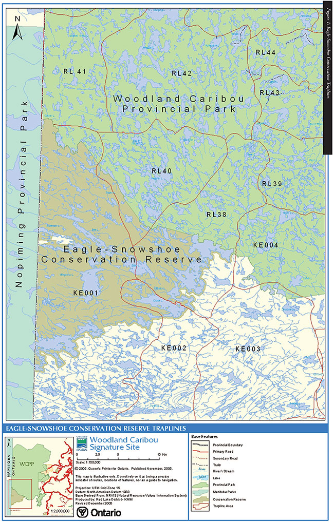
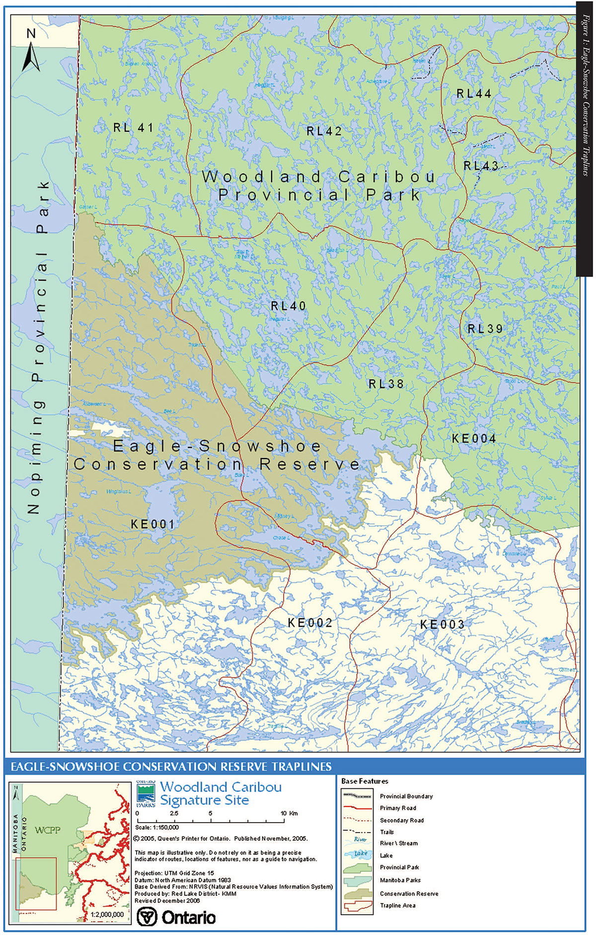
Land-based trails and portages exist within the conservation reserve including portions of snowmobile and canoe routes. Other trails exist to allow fur harvesters access to their trapline areas. During the winter, the frozen waterbodies also provide a means of snowmobile access to the conservation reserve. Please refer to Figure ESCR-1 for a map of documented trails within the conservation reserve as derived from the Natural Resource Values Information System (NRVIS). These trails represent routes that may be shared by canoeists and snowmobiles. There may be existing trails not captured through survey efforts.
Horseback riding, hiking and mountain biking trails have not been identified within the conservation reserve and are unlikely to exist due to the limited access to the area.
Management Direction:
Existing trails for motorized travel are permitted to continue provided that they do not negatively impact values for which the conservation reserve was designated. These trails will be considered authorized trails. New trail development, including tenure to support new trails, will not be permitted within the conservation reserve. The establishment of new trails would not be consistent with management efforts to maintain the wilderness character of the area. Snowmobile and all-terrain vehicle activity is permitted on existing trails; off trail use is permitted only for the direct retrieval of game. Should it be demonstrated that activities associated with the use of these existing trails compromise the values for which the conservation reserve was established (i.e. caribou habitat/migration routes), steps may be initiated to no longer authorize or permit the use of these trails.
4.2.16 Signage
Management Direction:
Educational signage may be permitted within the conservation reserve. Consideration may be given to establishing signage provided that it is used to convey messages that are consistent with the protection objectives of the conservation reserve. Signage must be displayed so as not to negatively impact the identified values of the protected area. This management plan does not support the posting of signs for the purpose of advertising.
4.2.17 Non-Motorized Recreational Travel
Eagle-Snowshoe Conservation Reserve abuts the south end of Woodland Caribou Provincial Park, a protected area that is well known for its wilderness canoe routes. Portage trails throughout the conservation reserve provide access to remote lakes for canoeists and recreationalists. Please refer to Figure ESCR-1 for a map that includes the known canoe/kayak routes within the conservation reserve.
Management Direction:
Non-mechanized recreational travel will continue to be permitted within the conservation reserve provided that there are no significant demonstrated conflicts including negative impact to identified values. New trail development to support these activities (e.g., new portages) will be considered subject to the 'test of compatibility.'
4.3 Fisheries
4.3.1 Commercial Fishing
Commercial fish are defined as "any fish that are harvested by the commercial fishing industry under the authority of a commercial fishing licence" (OMNR, 1987).
Commercial fishing has occurred on two of the largest lakes within the conservation reserve, Snowshoe Lake and Eagle Lake. Licences were granted during the late 1950s. The commercial licences were for the harvesting of walleye and northern pike. Early into the 1970s, testing for mercury contamination occurred in response to Dryden Paper Mill’s contamination of the English River system. The testing indicated that both Eagle Lake and Snowshoe Lake had high natural mercury concentrations, but these levels were not due to contamination. These lakes, however, were closed to the commercial fishery from 1972 to 1978. The fishery was re-opened again in 1979 for the harvesting of whitefish from both Snowshoe and Eagle Lakes. Activity continued until the licences were acquired by the MNR in 1989 based upon direction in the Kenora District Fisheries Management Plan.
Management Direction:
No new commercial fishing operations will be considered for the Eagle-Snowshoe area due to the retirement of the licences in 1989, the high cost of operating commercial fisheries in this remote area, and potential conflicts with the sport fishery.
4.3.2 Bait-fish/Leech Harvesting
Portions of five bait fish harvest areas and five leech harvest areas are within the Eagle-Snowshoe Conservation Reserve boundary. No opportunities for new harvest operations exist because all areas have been allocated in the past. Please refer to Appendix ESCR-3 for a list of the harvest blocks within the conservation reserve.
Management Direction:
Existing baitfish and leech harvest areas are permitted to continue unless there are significant demonstrated conflicts. Requests for transfers will be considered subject to the 'test of compatibility' and current MNR policy.
4.3.3 Sport Fishing
Eagle-Snowshoe Conservation Reserve contains high quality recreational fishing opportunities for walleye, northern pike, bass and lake trout. The majority of anglers who fish these lakes are flown into the area by floatplane and stay at one of the outpost camps, cottages or private lodges located within the conservation reserve boundary.
Management Direction:
Sport fishing is a permitted activity within the conservation reserve. No further management action is required at this time other than the implementation of the current annual Recreational Fishing Regulations Summary. This summary is in compliance with the federal Fisheries Act and Regulations and the provincial Fish and Wildlife Conservation Act.
Should changes to the sport fishing regulations be made, they should be considerate of the intent of this resource management plan; however, they will follow the appropriate processes which are outside the amendment procedures of this document.
Since access west of Sydney Lake has not been established and is no longer proposed (rationale for the North Kenora Pilot Project Agreement), and the term of the agreement has expired, the conservation sport fish limits only regulation for residents was reviewed and rescinded as part of the process to review Ontario’s sport fishing regulations for this Fisheries Management Zone. The conservation sport fish limits remain in place for non-residents of Canada.
4.3.4 Fish Stocking
No authorized fish stocking attempts have been made within the Eagle-Snowshoe Conservation Reserve.
Management Direction:
A requirement to stock fish in lakes is not anticipated at this time. However, this management plan supports this activity as a means to sustain the values which the conservation reserve was designated to protect. The conservation reserve will follow the most appropriate and current resource management direction applicable to the watershed. Fisheries programs, such as stocking, would be subject to the Class Environmental Assessment for Provincial Parks and Conservation Reserves. This would require an evaluation of the impact of the proposal and public consultation prior to approval.
4.3.5 Fish Habitat Management
Habitat management would entail efforts to sustain and/or promote aquatic and upland habitat to support the fisheries. This activity could include work to improve spawning beds and slope stabilization to prevent excess sediment from entering the aquatic habitat. No previous fish habitat management activities have occurred within the conservation reserve to date which may be a result of the limited access available to the site.
Management Direction:
Fish habitat management and improvement projects will be supported by this management plan. These activities would be consistent with the management objective of protecting natural heritage values within the conservation reserve. Specific programs would be subject to the Class Environmental Assessment for Provincial Parks and Conservation Reserves.
4.4 Forest Resources
As a result of a forest fire that swept through the northern section of the conservation reserve, a forest cover of jack pine, mixed jack pine and black spruce, and other mixed hardwoods now dominate the reserve. The southern two - thirds of the conservation reserve supports stands of mature jack pine, black spruce and scattered balsam fir on rock outcrops. The hardwood stands consist primarily of trembling aspen and white birch with a combination of balsam fir and white spruce. There is also a presence of tamarack in the poorly drained lowlands and along portions of the lake shorelines.
Bur oak savannahs are a significant feature of the Wingiskus Lake and Eagle Lake areas. These occurrences are significant because they are at the northern extent of their range and because of their relationship to prairie vegetation communities.
4.4.1 Commercial Timber Harvest
Prior to regulation, Eagle-Snowshoe Conservation Reserve was located within the Kenora Forest. The Sustainable Forest Licence (SFL) for the Kenora Forest is issued to Weyerhaeuser Company Ltd.
Management Direction:
Commercial timber harvest is not permitted within the conservation reserve. Furthermore, this management plan does not support any ancillary activities (i.e., work camps) associated with forest harvesting. This management direction applies to the commercial harvest of all tree species and other forest resources including Canada Yew.
4.4.2 Insect/Disease Suppression
As part of the boreal forest, portions of the conservation reserve have been subject to previous insect outbreaks including the Forest Tent Caterpillar (Malacosoma disstria), Spruce Budworm (Choristoneura fumiferana), and Jack Pine Budworm (Choristoneura pinus pinus). These natural processes will likely occur again in the future.
Management Direction:
The decision for the MNR to manage insect and disease outbreaks is usually related to saving mature timber until such time as harvesting can occur. As commercial timber harvesting is not a permitted use within the conservation reserve, these natural processes will be permitted to occur without intervention. However, if it is determined through appropriate processes that the forest/vegetation is threatened by an invasion of a non-native species, this management plan supports the application of control agents to the lands within the conservation reserve subject to the Class Environmental Assessment for Provincial Parks and Conservation Reserves. In this plan, non-native species includes those not native to Eagle-Snowshoe Conservation Reserve and the ecoregion that it represents.
4.4.3 Fuelwood and other small scale uses
Fuelwood is often required by leaseholders, cottagers and other property owners who do not have road access to their property. Fuelwood and other small scale uses are not intended for large-scale cutting for building structures such as log homes.
Management Direction:
The cutting of trees for non-commercial purposes may be authorized by permit to leaseholders, cottagers and other property owners who do not have road access to their property and who have no alternative means of obtaining fuelwood or other small scale uses outside of the conservation reserve. Any application will be subject to a 'test of compatibility' as well as a review and subsequent determination of the impact that such cutting would have on natural and cultural heritage values. This Resource Management Plan supports this activity provided that permits are limited to personal use only.
4.4.4 Vegetation Management
Vegetation of the conservation reserve is typical of the southern boreal forest region which is represented by thin soils. The site is located in a high occurrence area for forest fires and represents a dynamic ecology which can change dramatically over a short time period. Species that are found within the conservation reserve include birch, poplar, spruce, balsam fir and jack pine.
Large areas of exposed bedrock provide a suitable environment for the Woodland Caribou that inhabit the area. The lichens that grow on the bedrock provide them with good winter forage.
The organic make-up of the conservation reserve is primarily represented by swamps and marshes which provide excellent habitat for the waterfowl of the area.
Management Direction:
Vegetation management within the conservation reserve will follow the most appropriate direction applicable to the area immediately outside the protected area boundary. However, the adopted strategy must be consistent with the other management directions of this Resource Management Plan. Non-native species will not be deliberately introduced to the conservation reserve. Where established, introduced species threaten the life science values in the conservation reserve, a management plan and program may be developed for their control. This management direction is consistent with Conservation Reserves Policy.
4.4.5 Fire Suppression
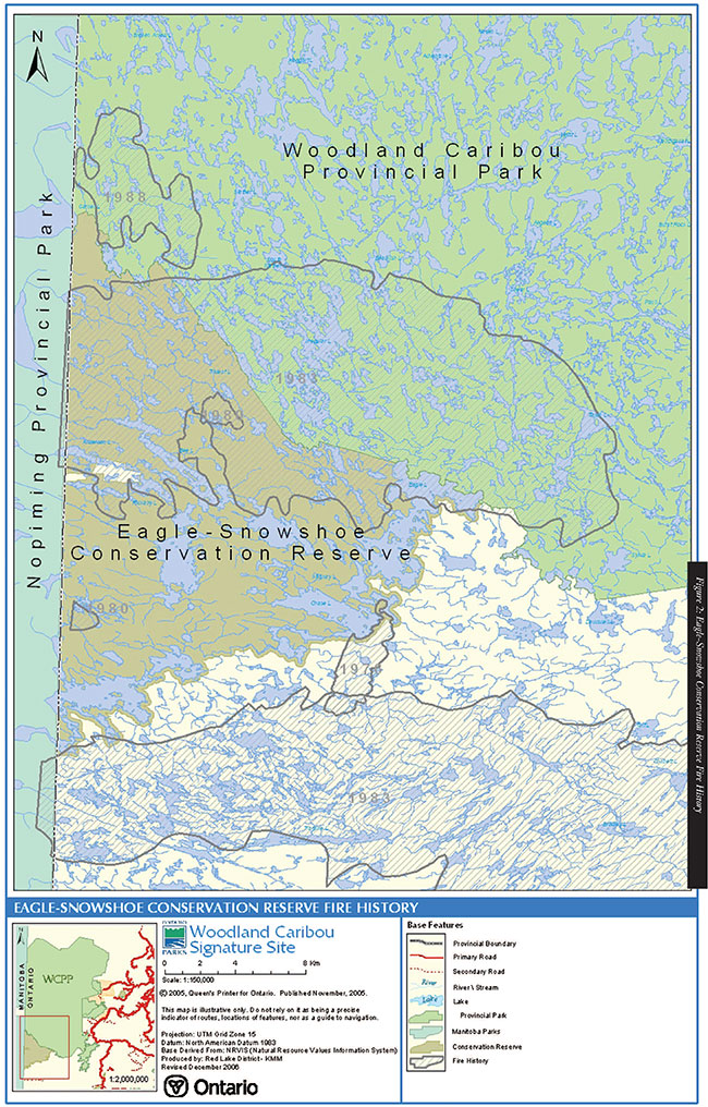
Please refer to Figure ESCR-2 for a fire history map of the conservation reserve and surrounding area.
Management Direction:
This Resource Management Plan recognizes fire as an important ecosystem process, fundamental to restoring and maintaining the ecological integrity of the natural environment represented within this conservation reserve. The role of fire and preliminary fire management objectives for the conservation reserve will be developed and documented through a Statement of Fire Intent. Following this process, a fire management plan will be developed which will specifically address objectives and prescribed actions with respect to fire response and fire use over a period of time. The Fire Management Plan will be developed in accordance with the Fire Management Planning Guidelines for Provincial Parks and Conservation Reserves and will involve public consultation as required.
Eagle-Snowshoe Conservation Reserve is located within the Boreal Fire Management Zone. An Interim Fire Response Plan has been developed for the conservation reserve to direct fire management until a fire management plan is completed. This direction is consistent with current Fire Management Policy for Provincial Parks and Conservation Reserves.
All fires within the conservation reserve will receive an appropriate response commensurate with the potential impact of each fire on public health and safety, property and values, the predicted behaviour of each fire, and the estimated cost of fire response. More detail on specific strategies can be found in the Woodland Caribou Signature Site Interim Fire Response Plan.
Whenever feasible, the OMNR fire program will endeavour to use "light on the land" techniques, which do not unduly disturb the landscape, in this conservation reserve.
Examples of light on the land techniques may include limiting the use of heavy equipment and limiting the number of trees felled during response efforts.
These management directions are consistent with Conservation Reserves Policy.
4.4.6 Prescribed Burning
Many boreal vegetation species are fire dependent that require fire as part of their natural life cycle. Fire is essential in the regeneration of these species, as well as in maintaining old growth red and white pine stands.
Management Direction:
Opportunities for prescribed burning to achieve ecological or resource management objectives may be considered. These management objectives will be developed with public consultation prior to any prescribed burning and reflected in the document that provides management direction for this conservation reserve. Plans for any prescribed burning will be developed in accordance with the MNR Prescribed Burn Planning Manual and the Class Environmental Assessment for Provincial Parks and Conservation Reserves.
4.5 Wildlife Resources
The Eagle-Snowshoe Conservation Reserve is located within Wildlife Management Unit #2. The area surrounding Wingiskus, Eden, Bee, Anderson, and Rickaby Lakes has been identified as having a high moose density. The remaining area to the east and south of these lakes, which includes Eagle, Chase, and Snowshoe Lakes, has a medium moose density. The area located from Raehill Lake north to the boundary of Woodland Caribou Provincial Park has a low moose density.
Furbearers included within the conservation reserve include beaver, muskrat, mink, fisher, marten, weasel, lynx, fox, wolf, squirrel, and black bear. There are portions of four registered traplines within the reserve boundary.
After World War II, a large herd of Woodland Caribou was spotted near Irregular Lake. This sighting prompted the protection of the caribou. Over the past decades, the Ministry of Natural Resources has adopted an approach of sustainable development in resource management intended to maintain caribou populations and habitat across the landscape.
During the summer months, some caribou migrate south from their winter range, located in Woodland Caribou Provincial Park, into the conservation reserve. Caribou sightings have been concentrated around Eagle Lake to Chase Lake where caribou calving areas have been confirmed. Kenora District implemented a collar telemetry program in 1997, as part of a commitment from the North Kenora Pilot Project Agreement to provide information on caribou behaviour and migration routes (Ranta, 2001).
4.5.1 Commercial Fur Harvesting
The Eagle-Snowshoe Conservation Reserve includes portions of four registered trapline areas; two are managed by Kenora District and two are managed by Red Lake District. One trapline cabin exists within the conservation reserve. Please refer to Figure ESCR-1 for a map of the trapline areas.
Management Direction:
Existing commercial fur harvesting activity by Aboriginal people can continue indefinitely. Transfer of traplines between status Indians is permitted and transfer of traplines to non-native trappers will be considered subject to the "test of compatibility". No new opportunities for trapline areas exist within the conservation reserve as all areas are currently allocated.
Existing trap cabins are permitted within the protected area. Relocation of the existing cabins and new cabins will be encouraged outside of the conservation reserve, but will be considered within the protected area if required. The location will be dependent on the protection of natural heritage values and other uses/activities. Considerations will be made for safety and practicality.
Trapping activities are regulated under the Fish and Wildlife Conservation Act and the Endangered Species Act, and are summarized in the annual Summary of the Fur Management Regulations. Length of trapping season varies, depending on the species being harvested.
4.5.2 Commercial Bear Hunting
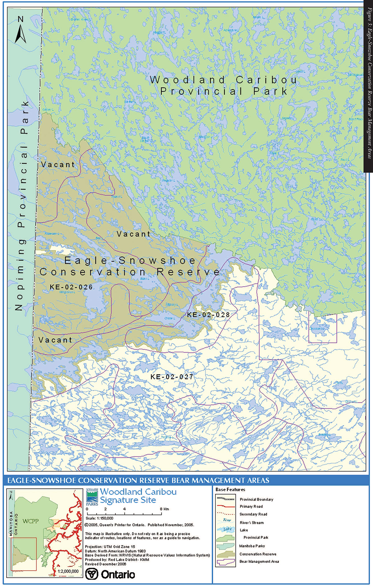
Commercial bear hunting includes tourist operators providing bear hunting services to non-resident hunters. There are portions of six bear management licence areas that are located within the conservation reserve; three are vacant; three are currently allocated to operators and are managed by Kenora District. Please refer to Figure ESCR-3 for a map of the bear management areas.
Management Direction:
Existing authorized operations within the conservation reserve are permitted to continue. Consistent with conservation reserve policy, licences will not be issued for any of the three bear management areas which have never been allocated in the past. Transfers of BMA licences will be considered subject to the 'test of compatibility' provided that there are no demonstrated impacts to the values the conservation reserve is intended to protect.
4.5.3 Hunting
The conservation reserve is located within Wildlife Management Unit (WMU) 2. Both resident and non-resident hunters target moose, white-tailed deer, black bear and upland birds. Moose hunting provides a quality tourism opportunity for operators in the area.
Management Direction:
Hunting is a permitted activity within the conservation reserve and is regulated under the Fish and Wildlife Conservation Act, the Migratory Birds Convention Act, and the Endangered Species Act. The construction of permanent "hunt camps" will not be permitted within the conservation reserve (see section 4.2.7).
4.5.4 Wildlife Population Management
Management Direction:
Wildlife population management will follow the most appropriate and current resource management direction that is applicable to the area immediately outside the conservation reserve boundary. This direction will be consistent with other management direction within this Resource Management Plan.
4.5.5 Wildlife Viewing
Management Direction:
The conservation reserve was designated to protect the significant natural resource values that occur within the Eagle-Snowshoe area. Wildlife viewing is consistent with management objectives and this activity is supported through this management plan.
4.6 Other Alternate Uses
4.6.1 Collecting
The Ministry of Natural Resources does not issue permits for commercial collections of natural resources and this management plan does not support this activity. Collections of a personal nature, such as gathering wildflowers and antler sheds, will be considered an existing use and are supported by this management plan. However, collectors need to be aware that these activities may be subjected to other legislation (i.e., Endangered Species Act).
4.6.2 Food Harvesting (Commercial)
Commercial food harvesting would include activities such as blueberry picking or the harvesting of wild mushrooms for the purpose of selling for profit. Currently there is no known commercial food harvesting operations occurring within the Eagle-Snowshoe Conservation Reserve.
Management Direction:
This management plan does not support commercial food harvesting within the conservation reserve as this activity may negatively impact values which the conservation reserve was designated to protect.
4.6.3 Food Gathering (Personal)
Food gathering would include blueberry picking or wild mushroom picking for personal use. This activity does not include hunting or fishing.
Management Direction:
Personal food gathering is a permitted within the conservation reserve and will be supported by this management plan.
4.6.4 Historical Appreciation
The cultural heritage values of the conservation reserve seem to be limited to the pre-historic hunter-gatherers of the boreal forest and Canadian Shield. The fur trade period is well represented within the area through its use as a travel route to local trading posts in the Red Lake area and on Lake Winnipeg. These travel routes play a key role in understanding the economic and ecological relationships of the people who have occupied the land for the past 6,000 years.
In the Eagle-Snowshoe conservation reserve there are 11 recorded archaeological sites. Most of these sites, which include small campsites, were identified during brief surveys for the West Patricia Inventory Project conducted during the late 1970's and early 1980's. In order to protect these sensitive values, specific site locations are protected and are not published in this management plan.
Management Direction:
Ontario archaeological sites and artifacts are protected through provincial legislation under the Cemetery Act, the Ontario Heritage Act and the Planning Act. Alteration, destruction, and/or removal of any archaeological values are prohibited by law and could result in prosecution and significant fines. Archaeological research or studies undertaken will be permitted through this management plan, but will be subject to the Acts identified above prior to initiation of any study.
Furthermore, approved and licensed research may be beneficial in documenting the cultural/historical significance of the protected area. Additional studies could help to identify and ultimately ensure the protection of historical artifacts, provided that the research is conducted in a manner that does not compromise the values that have been previously documented for the conservation reserve.
This management plan will continue to support the protection of the area’s historical archaeological values.
4.6.5 Inventory/Monitoring
Management Direction:
Research inventories and monitoring activities are permitted within the conservation reserve. These activities are encouraged in order to provide a better understanding of the natural processes occurring in the area and to enhance the protection of significant values through improved planning and management. This management plan supports the continuation of these activities provided that they do not negatively impact the values the conservation reserve is intended to protect.
Individuals or groups with an interest in conducting research in this conservation reserve are required to submit a completed application to the Ministry of Natural Resources. Further information about this process and the required application are available at http://www.ontarioparks.com/english/form2.html (link currently not active).
4.6.6 Wild Rice Harvesting
Under the Wild Rice Harvesting Act (1960), except under the authority of a licence, no person shall harvest or attempt to harvest wild rice on Crown land. In 1978, a five-year moratorium was passed on issuing additional licences to any non-native persons until such a time that "the market potential could support increased production by non-native harvesters". Five years later, a review of that decision resulted in the moratorium being extended indefinitely in the Kenora and Dryden Districts for non-native harvesters. Current harvesting of wild rice is managed by individual First Nations Bands.
Management Direction:
Commercial wild rice harvesting rights within the Eagle-Snowshoe area are held by Wabaseemoong Independent Nations members and harvesting for personal use is permitted for Treaty 3 status members. Non-natives and non-status individuals cannot harvest rice for any use. Should opportunities for commercial wild rice become available in the conservation reserve, an amendment to this plan will be considered.
5.0 Amendments to Resource Management Plan
Every effort has been made to provide management direction that addresses current activities and levels of use within the Eagle-Snowshoe Conservation Reserve. Efforts were also made to anticipate and plan for future resource use in the preparation of this management plan.
There is no intent to carry out a comprehensive review of the Eagle Snowshoe Conservation Reserve Resource Management Plan at any prescribed interval. Using adaptive management, the resource management policies in this document will be kept current through periodic amendments resulting from changes in government policy, new resource information or in response to public need.
Proposed amendments must not alter the overall intent of the Eagle Snowshoe Conservation Reserve Resource Management Plan. An amendment to the plan may be requested at any time and the District Manager will decide whether or not to consider it. Requests for amendments must have a basis in fact, demonstrably relate to the scope of the plan, and respond to changing resource conditions, new information, changing government policies or public need. The Ministry of Natural Resources also has the authority to initiate amendments in response to new information or changed conditions.
Amendments will be classified as either minor or major. Minor amendments are those changes that do not have a negative effect on the public, adjacent landowners or the environment and are generally administrative in nature. Minor amendments will be approved by the District Manager and will not normally be subject to public consultation. Major amendments have a significant social, economic and/or environmental impact. Major amendments will be reviewed by the District Manager and submitted to the Regional Director for approval. Public consultation will occur for all major amendments and notice of all major amendments will be posted on the Environmental Bill of Rights registry.
6.0 References
Blackburn, C.E. Blackburn Geological Services, Earth Science Inventory Check List for Eagle-Snowshoe Conservation Reserve, 2001
Blackburn Geological Services, Earth Science Inventory for Eagle-Snowshoe Conservation Reserve, 2000
Jones, Mike. Northern Bioscience, Life Science Inventory for Eagle-Snowshoe Conservation Reserve, 2000
Northern Bioscience, Natural Heritage Area-Life Science Checksheet for Eagle-Snowshoe Conservation Reserve, 2001
Kenora District Fisheries Management Plan, 1987-2000
OMNR Northwest Region, Eagle-Snowshoe Conservation Reserve Background Information Document
OMNR Northwest Region, Eagle-Snowshoe Conservation Reserve Recreational Inventory Report, 2001
Ranta, B.. OMNR, Report on Woodland Caribou and Their Use of Habitats in the Kenora Management Unit and Southern Portions of Woodland Caribou Provincial Park. 2001
Appendix ESCR 1: Permitted Uses Summary Table
Land and Waters Resource Use
| Activity | Permitted | Guidelines |
|---|---|---|
| Aggregate Extraction | No | |
| Energy Transmission and Communications Corridors | No | Unless no demonstrated alternatives exist. |
| Commercial Hydro Development | No | |
| Mineral Exploration and Development | No | |
| Peat Extraction | No | |
| Commercial Tourism Existing | Yes | |
| Commercial Tourism New | No | |
| Outfitting Services Existing | Yes | New ecotourism opportunities may be considered subject to the "test of compatibility". |
| Outfitting Services New | No | |
| Outpost Camps Existing | Yes | |
| Outpost Camps New | No | |
| Resorts/Lodges Existing | Yes | |
| Resorts/Lodges New | No | |
| Private Recreation Camps | No | |
| Campgrounds | No | |
| Crown Land Camping Resident | Yes | |
| Crown Land Camping Non-resident | Yes | |
| Campsite Designation | No | |
| Access Roads Existing | Yes | |
| Access Roads New | No | |
| Crown Land Dispositions | No | No overnight roofed accommodations will be permitted. |
| Commercial Boat Caches Existing | Yes | |
| Commercial Boat Caches New | Yes | New caches may be considered if a net benefit for the Signature Site is demonstrated. |
| Resource Harvester Boat Caches Existing | Yes | Relocation of existing boat caches, or new boat caches will be subject to the "test of compatibility". |
| Resource Harvester Boat Caches New | Yes | |
| Recreation Boat Caches Existing | Yes | Relocation of existing boat caches, or new boat caches will be subject to the "test of compatibility". |
| Recreation Boat Caches New | Yes | |
| Trail Development Existing | Yes | |
| Trail Development New | No | |
| All Terrain Vehicle Use Existing | Yes | |
| All Terrain Vehicle Use New | No | |
| Snowmobiling Existing | Yes | |
| Snowmobiling New | No | |
| Rock Climbing Existing | Yes | |
| Rock Climbing New | No | |
| Signage Existing | Yes | |
| Signage New | Yes | |
| Motor Boat Use | Yes | |
| Non-Motorized Recreation Travel | Yes |
Fisheries Resource
| Activity | Permitted | Guidelines |
|---|---|---|
| Commercial Fishing | No | |
| Bait-fish Harvest Existing | Yes | Requests for transfers will be considered based on the 'test of compatibility'. |
| Bait-fish Harvest New | ||
| Sport Fishing | Yes | Subject to conservation limits in accordance with the current annual Recreational Fishing Regulations Summary. |
| Fish Stocking | Maybe | Subject to the Environmental Assessment Act. |
| Fish Habitat Management | Yes |
Forestry Resources
| Activity | Permitted | Guidelines |
|---|---|---|
| Commercial Timber Harvest | No | |
| Insect/Disease Suppression | Maybe | If forest/vegetation is threatened by infestation of non-native species. |
| Fuelwood and other small scale uses | Maybe | Applications will only be considered from property owners for personal use. |
| Vegetation Management | Yes | Consistent with management direction for areas immediately outside of conservation reserve. |
| Fire Suppression | Yes | According to Forest Fire Management Strategy for Ontario and Conservation Reserves Policy. |
| Prescribed Burning | Maybe | Plans to be developed in accordance with MNR Prescribed Burn Planning Manual and the Class EA for Provincial Parks and Conservation Reserves. |
Wildlife Resources
| Activity | Permitted | Guidelines |
|---|---|---|
| Commercial Fur Harvesting Existing | Yes | Existing commercial fur harvesting activity by aboriginal people can continue indefinitely. Transfer of traplines between status Indians is permitted and transfer of traplines to non-native trappers will be considered subject to the "test of compatibility". |
| Commercial Fur Harvesting New | No | No new opportunities for trapline areas exist within the conservation reserve as all areas are currently allocated." |
| Trap Cabins Existing | Yes | Relocation of existing cabins may be considered subject to "test of compatibility". |
| Trap Cabins New | No | New cabins will be encouraged outside the conservation reserve, but may be considered within the CR in the interest of safety and practicality. |
| Bear Hunting by Non-residents Existing | Yes | Transfer in BMA ownership will be considered subject to "test of compatibility". |
| Bear Hunting by Non-residents New | No | |
| Hunting | Yes | |
| Wildlife Population Management | Maybe | In accordance with the most appropriate and current direction that is applicable to the area immediately outside the conservation reserve boundaries. |
| Wildlife Viewing | Yes |
Other Alternate Uses
| Activity | Permitted | Guidelines |
|---|---|---|
| Collecting Commercial | No | |
| Collecting Personal | Yes | Subject to applicable legislation. |
| Food Harvesting (Commercial) | No | |
| Food Harvesting (Personal) | Yes | |
| Historical Appreciation | Yes | Subject to applicable legislation. |
| Inventory/Monitoring | Yes | |
| Law Enforcement | Yes | |
| Research | Yes | Subject to applicable legislation. |
| Wild Rice Harvesting Existing | Yes | Subject to applicable legislation. |
| Wild Rice Harvesting New | No |
Appendix ESCR-2: Test of Compatability
Appendix ESCR-3: Bait-fish/Leech harvest blocks of ESCR (C2405)
| Bait-fish/Leech Block # | Managed by: |
|---|---|
| 507951 | Kenora District, OMNR |
| 506951 | Kenora District, OMNR |
| 506944 | Kenora District, OMNR |
| 505951 | Kenora District, OMNR |
| 505944 | Kenora District, OMNR |
Figure 1: Eagle-Snowshoe Conservation Traplines
Enlarge map for Eagle-Snowshoe Conservation Traplines
Figure 2: Eagle-Snowshoe Conservation Reserve Fire History
Enlarge map for Eagle-Snowshoe Conservation Reserve Fire History
Figure 3: Eagle-Snowshoe Conservation Reserve Bear Management Areas

Enlarge map for Eagle-Snowshoe Conservation Reserve Bear Management Areas