Earl Rowe Provincial Park Management Plan
This document provides direction on the management of Earl Rowe Provincial Park.
Ministry of Natural Resources
Note: This document has been scanned and formatted, and therefore is slightly different from the original version.
-March 2002
Additional copies of this publication are obtainable from:
Ministry of Natural Resources
10670 Yonge Street
Richmond Hill, Ontario L4C 309
©1985, Government of Ontario
"We are pleased to approve the Earl Rowe Provincial Park Management Plan, as official policy for the management and development of this park. The plan reflects this Ministry’s intent to protect natural and cultural features of Earl Rowe and maintain and develop high quality opportunities for outdoor recreation and heritage appreciation for both residents of Ontario and visitors to the Province."
Signed by:
M, Fordyce
Regional Director
Central Region
Signed by:
N. Richards
Director, Parks and
Recreational Areas Branch
1. Introduction
Earl Rowe Provincial Park (hereafter referred to as "Earl Rowe" or "the park") is a major recreation- oriented provincial park, located within close proximity to Metro Toronto.
As a recreation park on Toronto’s doorstep, Earl Rowe has been developed to provide a large number of camping opportunities (555 sites) in addition to a day-use area, sited around a 34 ha man-made reservoir. The reservoir is the recreation focal point of the park, offering opportunities for fishing and boating. Swimming opportunities are provided at the recently constructed swimming pool. From 1980 to 1983, day-use attendance increased 3% to approximately 50,000 visitors annually. During this same period, camper nights increased by 1%. In July and August of 1982, the park had 41% campsite occupancy.
Specifically, Earl Rowe is situated on the Boyne River in the Township of Tosorontio, in the County of Situcoe. The park is approximately 2 km northwest of the Town of Alliston, and approximately 85 km northwest of Metro Toronto (see Figure 1). The Boyne River is recognized as a major coldwater fish river containing a significant migration of rainbow trout and salmon.
The park’s original land base, to the east of the 7th Concession (see Figure 2) was donated to the Province of Ontario in the late 1950's for a provincial park by the former Lieutenant Governor of Ontario, The Honourable Earl Rowe. Since that time, the park has expanded to the west of this concession, to include in total 312 ha. The park’s two land parcels, located on both sides of the concession, are connected by a combined vehicular pedestrian underpass.
The park is noted for its recreational opportunities and aesthetic qualities more so than for its earth/life science and cultural resources.
Since the majority of the park’s land base was under cultivation until recently, only a few isolated natural wooded areas remain. These areas include two isolated woodlots and the wooded portion of the Boyne River Valley.
The park is located on the lake bed of ancient Lake Algonquin whose ancient shoreline is evidenced, in the park, by a steeply-rising slope along the northern park boundary.
The park contains evidence that it once supported at least two pre-Archaic campsites (3,000 to 5,000 B.C.). As well, during the 1800's, the land within the park’s boundary had a railroad through it, a mill and mill pond, and a tiny community called Meadowbrook, which contained a school, a blacksmith’s shop, workers' houses and a few homesteads. The Meadowbrook school (circa 1899) located in the southwest corner of the park is the only structure that has survived intact from this era.
This management plan is being prepared for the purpose of planning, development and management of the park’s natural, cultural and recreational resource.
2. Summary of Significant Issues and Policy Decisions
Park management is concerned about the deteriorating water quality and sedimentation of the reservoir which threatens the attractiveness of reservoir-based water recreation activities. Swimming opportunities once available in the reservoir are now provided in a pool. However the significant rainbow trout and salmon migrations through the reservoir are threatened. The Ministry of Natural Resources will take whatever steps necessary on its own and with other agencies in improving the environmental quality of the reservoir.
3. Park Policies
3.1 Park Classification
The classification of Earl Rowe is "recreation" in recognition of the park’s outstanding recreational facilities and opportunities.
Figure 1: Regional Context
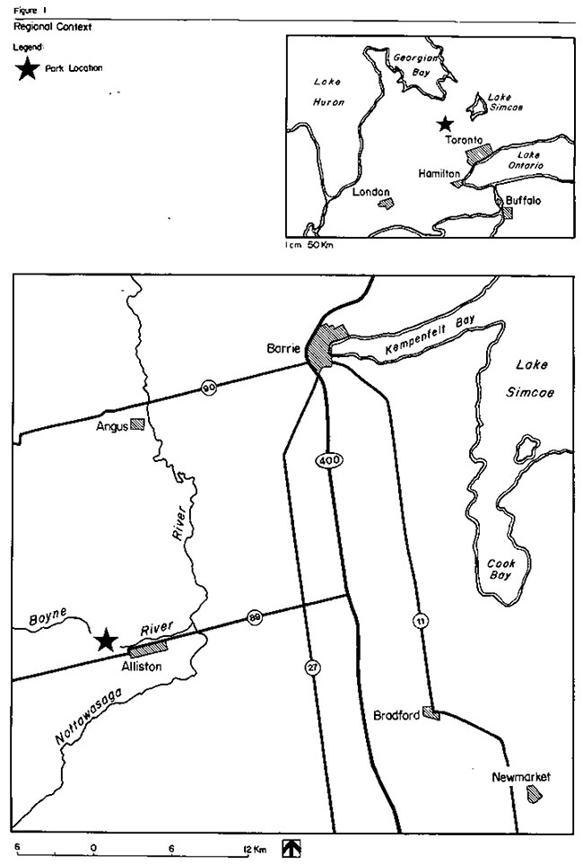
Figure 2: Existing Facilities
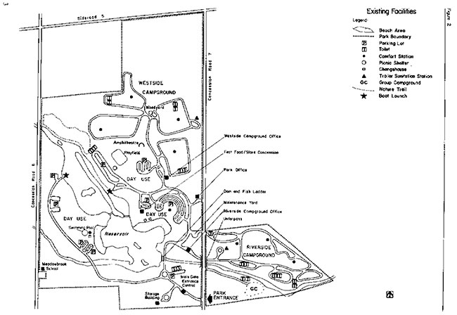
Enlarge: Figure 2: Existing Facilities
3.2 Park Goal
To maintain and operate Earl Rowe as a major recreation-oriented provincial park providing a wide variety of outdoor recreational opportunities
3.3 Park Objectives
3.3.1 Recreation Objective
The recreation objective of the Provincial Parks system is to provide provincial park outdoor recreation opportunities ranging from high-intensity day use to low-intensity wilderness experiences.
The recreation objective of this park is to provide a variety of day-use opportunities, some of which are water based and capable of handling large numbers of people.
To provide a large number of camping opportunities including family camping and group camping in a variety of settings and with a variety of services. According to Huronia District Land-Use Guidelines:
- the parks’s 555 campsites are estimated to represent 23.8% of the districts’s campsite opportunities to the year 2000 (presently the park offers 39%),
- the park’s 248 meters surrounding the pool are estimated to represent 1.2% of the district’s swimming opportunities to the year 2000 (presently the park offers 1.5%),
- the park’s 1,370 picnic tables are estimated to represent 20% of the district’s picnicking opportunities to the year 2000 (presently the park offers 28.4%).
- (N.B.) The difference in camping, swimming and picnicking percentile opportunities between present day and the year 2000, represents an estimated increase in the number of similar opportunities to be made available elsewhere and does not reflect any proposed decrease in facility based opportunities at Earl Rowe.
3.3.2 Heritage Appreciation Objective
The heritage appreciation objective of the Provincial Parks system is to provide opportunities for exploration and appreciation of the outdoor natural and cultural heritage of Ontario.
The heritage appreciation objective of this park is to provide a range of self-use opportunities for the exploration, interpretation and appreciation of the natural features and cultural resources of the park. Interpretive facilities and programs will vary according to the significance of the resource, its accessibility and its required level of protection. Natural features include the steep meadow-covered slopes of the ancient glacial Lake Algonquin shoreline, and the variety of river valley landforms. Cultural features include the Meadowbrook school and two pre-Archaic campsites.
3.3.3 Tourism Objective
The tourism objective of the Provincial Parks system is to provide Ontario’s residents and out-of-province visitors with opportunities to discover and experience the distinctive regions of the province.
The tourism objective of this park is to provide Ontario’s residents and out-of-province visitors with camping and day-use opportunities close to both Metro-Toronto and to the Huronia recreational region.
The park currently contributes almost three million dollars to the provincial economy annually through park expenditures and tourist spending. It is the objective of the ministry to maintain and possibly increase the economic contribution of this park to the local economy.
3.3.4 Protection Objective
The protection objective of the Provincial Parks system is to protect provincially-significant elements of the natural and cultural landscape of Ontario.
The protection objective of this park is to protect the natural and cultural resources of the park through zoning that reflects the particular resource management needs of an area as well as being aware of the recreational pressures placed on these resources. Resources worthy of protection include deciduous, coniferous and boreal forests, riparian valley landforms, steep slopes of ancient shorelines, the Meadowbrook school and two pre-Archaic campsites.
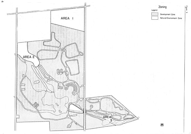
3.4 Zones and Zone Policies
All lands within the park will be zoned (see Figure 3) in recognition of their existing and potential environmental qualities, required protection and their potential for recreation and interpretive use within the context of the four objectives (see 3.3 Park Objectives).
3.4.1 Development Zone (303 ha)
- This zone encompasses the majority of the park’s land base, including the reservoir and the pool. Facilities for day use, camping, park maintenance/administration, and associated open space are located in this zone. As well, the historic Meadowbrook school, is located in this zone.
Development Zone Policies
- To improve the landscape aesthetics and the environmental quality of this zone through plantings.
- To maximize water-based day-use recreational opportunities by maintaining and improving upon existing resources/facilities and the provision of new facilities as deemed necessary.
- To maintain the present level of campground development, allowing for facility improvements and campsite rehabilitation.
- To distribute more equitably the large numbers of day users among the existing day-use facilities.
- To protect and maintain as much as possible the cultural resource found in this zone.
3.4.2 Natural Environment Zone (9 ha)
- Three "natural environment" zones in the park contain aesthetic landscapes with significant natural characteristics. A description of the three areas is as follows:
Area 1 - (5 ha)
-
This area includes the steep meadow—covered slopes (over 30 m in height) in the park’s northern corner. The area exhibits a variety of landform themes including erosion processes and slope stabilization, and presents a dramatic display of the ancient glacial Lake Algonquin shoreline which runs parallel to the base of this slope. It includes a broad, shallow moist depression at the base of the slope which has a slow easterly streamflow. This depression’s origin may be associated with the direction of shoreline currents of Lake Algonquin. The park’s wells are located in this zone.
Area 2 — (2.5 ha)
- This area presents a variety of river valley landforms, such as valley meander basins, slopes, abandoned flow channels, and terraces, with a very disturbed vegetative community pattern because of past cutting and construction of the reservoir. It does have a marsh/scrub swamp system and a distinctive dry sandy berm site. As well several significant plant species are located here. (See Section 5.3.1 Vegetation, in Earl Rowe Provincial Park Management Plan —Background Information Document.)
Area 3 — (1.5 ha)
- This area occupies the general valley of the Boyne River below the dam. The dam and fish ladder are included in this area since they present a good visual display of fish species migrating along the Boyne River. The entire river, in this area below the dam, is a fish sanctuary during spring trout migration. Area 3 presents a variety of representative river valley features similar to those found in Area 2. As well, a wide variety of disturbed plant communities including forests, scrub and marshes, are represented.
Natural Environment Zone Policies
- To protect the significant natural features from detrimental forms of development and recreational use.
- To perform vegetative management, including planting if necessary, to enhance the environmental quality of this zone.
Figure 3: Zoning
4. Resource Management
4.1 Landform and Water Management
An interministerial water management committee (Erosion and Sedimentation Coordination Committee) have been notified of the implications to the park and the reservoir of:
- poor soil conservation practices upstream
- bacterial contaminants entering the river from communities (Shelburne), as well as domestic and agricultural practices upstream
- Dredging and/or rechanneling of the Boyne River as it enters the park and the reservoir may occur, if necessary, if engineering studies prove that such measures will improve the sedimentation problem and the quality of water in the reservoir. The environmental impact associated with dredging will be addressed.
- The artificial beaches will be replenished with imported sand as needed.
- Water level management of the reservoir will continue requiring the lowering of the water level every fall and raising this level every spring.
- The reservoir will be maintained and operated as required to enhance the migration and spawning of fish.
- River and reservoir bank stabilization projects will be initiated where required, as funds and priorities permit.
- Erosion control measures along the steeply-faced slope of the ancient Lake Alqonquin shoreline, in the northern end of the park will include natural vegetative regeneration in conjunction with planting.
- The drainage ditch crossing the northern extension of the park will be maintained so as to ensure positive drainage.
4.2 Vegetation Management
- Management of existing vegetation and proposed planting projects including a mowing program will be addressed in a Vegetation Management Plan with emphasis on the following:
- using native plant species of value to wildlife
- increasing the number of shade trees in the day— use areas (especially in west day-use area) and open campsites
- plants for buffering between campsites
- plants that stabilize slopes (e.g., colonizing types)
- ongoing appropriate maintenance (e.g., staking, pruning, watering) of new plants, especially during the first few years, to ensure a high rate of plant survival and healthy growth.
- Park management will protect those significant vegetation communities and plants as identified in "A Reconnaissance Life Science Inventory of Earl Rowe Provincial Park" (see Appendix A, Earl Rowe Provincial Park Management Plan - Background Information Document)
- The vegetative communities in the park will be allowed to evolve with minimum management interference, except for the following situations:
- management of forest cover in the campgrounds to ensure visitor safety, aesthetics and the long- term health of the stand.
- selective pruning and thinning of existing trees, located just below the park entrance control structure, in order to keep the scenic view, over the reservoir, unobstructed.
- insects and diseases which do not threaten the existence of the plant communities, will be allowed to continue undisturbed in all zones of the park.
- where control is desirable, it will be directed as narrowly as possible to the specific insect or disease so as to have minimal effects on other components of the park’s environment.
- Park management will assess the amount of maintained grassed areas required for practical park purposes in both the campground and the day—use area. Mowing will be discontinued on those grassed areas not required. Natural regeneration of these areas may be assisted with the planting of native plant species.
4.3 Fauna Management
- Sport fishing will be encouraged in park waters.
- Earl Rowe is a designated Provincial Fishing Area which will normally be stocked by the ministry.
- That section of the Boyne River, stretching from below the dam to the park’s eastern boundary will continue to be a fish sanctuary during certain designated periods of the year.
- The existing ministry program located ~t the fish ladder, involving capturing, measuring, tagging and releasing fish (e.g., rainbow trout) for research purposes, will continue as required.
- The park’s reservoir and river may be closed to fishing temporarily for fisheries research or management purposes.
- Commercial bait fishing will not be permitted.
- Nuisance animal control will be carried out under the strict supervision of or directly by the Ministry of Natural Resources.
- Wildlife habitat improvements will be addressed in the Vegetation Management Plan.
4.4 Cultural Resource Management
- If funding and priorities permit appropriate maintenance measures may be taken, as required, to protect the Meadowbrook school from further deterioration.
- The two pre-Archaic campsites located in the northwest and southeast corner of the park as well as the Fletcher mill site in the vicinity of the present dam will be protected from any further destructive forms of development and land management.
5. Client Services Management
5.1 Visitor Services
Earl Rowe, as a popular major recreation-oriented provincial park, containing interesting life/earth science features and cultural resources, provides a wide variety of quality visitor service opportunities. The goal is to provide visitors with a system of basic park information and a wide variety of family- oriented recreational facilities and programs. Of the four visitor service components, (i.e., communication, recreation, interpretation and outdoor education) the former two are emphasized at the park.
5.1 .1 Communication
Objectives of this component should include the following:
- informing visitors about the park, its services, facilities and management concerns
- informing visitors about recreation and interpretive opportunities in the local area
- informing visitors of the role of the Ministry of Natural Resources
- instilling a sense of respect in visitors for the park environment
- providing a means of feedback for visitors to communicate with the Ministry
The objectives outlined above will be achieved through all or some of the following: publications, signage, audio-visual presentations, displays, mass media and personal contact including campsite visitation.
5.1.2 Recreation
The park’s self-use and staff-led recreation activities will include:
- self-use recreation with a waterfront for sunbathing and canoeing, a pool for swimming, play fields, hiking and fitness trails. There are also opportunities for bicycling and cross-country skiing.
- to supplement the park’s recreation facilities, a free recreation-equipment loan program may be offered.
- limited staff-led recreation activities will be provided as funds and staff priorities permit. They may include campfire, craft, and water- oriented programs and fishing derbys. Such programs should lead to an involvement with the natural and cultural features of the park.
5.1.3 Interpretation
The following are two general interpretive themes at Earl Rowe:
- Resource use and management
- utilization of the site’s resources by pre—Archaic people, the settlers of the 1800's, and modern-day recreationlists.
- ecological implications of man’s utilization and management of the park’s resources: Earl Rowe fisheries management program, (i.e., put and take stocking), the fishway operation (i.e., fish ladder).
- Glacial features
- ancient Lake Algonquin shoreline.
- geological exposures along banks of reservoir and the Boyne River.
- river valley environments.
These two themes are considered to be of local to regional significance and will be presented through various media, activities and facilities.
Self-use interpretive opportunities will include using park nature trails, trail guides, fish ladder and display boards.
Interpretation may also be offered through staff-led recreational activities such as amphitheatre programs and special events and demonstrations.
5.1.4 Outdoor Education
Earl Rowe will encourage local and regional school boards to make educational self-use of the park’s resources. Facilities that will enhance this experience include the dam and fish ladder with its interpretive display boards, the amphitheatre and nature trails.
5.2 Recreation Management
- The park will be managed to optimize its recreational potential, especially water-based opportunities.
- Existing facilities will be upgraded and additional ones provided, as needed, to enhance and maximize the recreational opportunities of the park.
- Use of the pool will be promoted, while swimming in the reservoir will be discouraged.
- During off-season, when the park’s facilities are closed, park patrons have access to the park’s land base for recreational pursuits (e.g., fishing, walking, cross-country skiing, snowmobiling, etc.). Snowmobiling will occur only on the main trail part of the Huronia trail system. Vault privies, waste receptacles and parking are available facilities during the off-season.
- Park activities and facilities will be directed by guidelines and procedures in accordance with the current Earl Rowe Management/Operating Plan.
- Initiatives will be taken to enhance and promote the image and accessibility of the Fish and Wildlife office to hunters, trappers, fishermen and the general public. As long as deemed appropriate, conservation officers' and hunters' exams will continue to operate out of the park office.
5.3 Commercial Services
The following existing commercial tourism services are available at the park:
- wood concession
- boat concession
- fast food/store concession
- pool concession
Additional concessions may be added or existing ones modified in some way, according to the need and within policy guidelines.
5.4 Marketing
The following is a ranking of common provincial park marketing strategies, listed in decreasing order of importance, as they apply to Earl Rowe.
- Hold present customers long
- Repatriate customers lost during the rowdyism of the 7O's.
- Increase day use (home based) where high volume can be achieve
- Increase general awareness of park system.
- Attract day users who will stay in local commercial accommodations and use local services.
- Increase private sector involvement in parks and encourage park visitors to use local commercial services.
Marketing and operational initiatives, as outlined in the Marketing Manual for Earl Rowe Provincial Park, will be implemented in order to obtain the above results.
6. Development
Facility development is presently adequate to meet existing and future anticipated demands placed on them. Most proposed development items are minor in nature, and are basically required to upgrade existing facilities. Examples are the provision of showers in the Riverside Campground and the continuation of planting trees and shrubs, especially in the west beach area and the campgrounds.
No new utility lines or rights-of-way may be developed, except for those required for servicing the park. Future major work, on existing and proposed primary and secondary lines, will include burying these lines.
The campground will undergo campsite rehabilitation, as required, allowing up to 10% of the sites being closed at any one time.
If an appropriate water theme proposal complimentary to the pool is presented, the Ministry will consider it.
Preparation of a Vegetation Management Plan will be given top priority.
7. Implementation Strategy
The planting of trees and shrubs according to a proposed planting program in a Vegetation Management Plan (see section 4.2) is a high priority to be included in an annual tree planting program. Landscape improvements to the west beach area is an essential element in the park’s attempt to increase the day use of this area and promote pool use. As well, priority will be given to the establishment of buffer plantings to the west of the pool in order to decrease air-borne pollutants (e.g. dust, sand, pollen) from reaching the pool.
The provision of showers in the Riverside Campground, in addition to those already available in the Westside Campground, is dependent on funding.
8. Summary of Public Consultation
Public consultation during the management planning process for Earl Rowe focused on the local area and included the following:
- a news release and advertisement in the Alliston Herald, and Shelborne Free Press and Economist (news release only) advising that this management plan was available for review at the park and/or district office
- copies of this plan forwarded to local levels of government for review (Town of Alliston, Tosorontio Township, Nottawasaga Valley Conservation Authority)
- copies of the news release sent to the Federation of Ontario Naturalists and the Ontario Federation of Anglers and Hunters.
- where appropriate, contact will be made with adjacent landowners, by park management, to inform these landowners of the plan and its contents
- announcements and posters on display in the park advising park visitors of availability of plan for review
All comments and suggestions received from the public were considered while finalizing this plan. This management plan will be reviewed when major issues surface and at least once within the next ten years. Any necessary plan amendments will be made with public involvement in accordance with apparent needs.
9. References
Berg, Harjula, Semple; Earl Rowe Provincial Park — Master Plan, 1970, Ontario Department of Lands and Forests — Parks Branch.
Bishop, Fred; Interpretive Prospectus for Earl Rowe Provincial Park, 1973.
Bishop, Fred; Interpretive Media Proposal— First Draft, EarlRowe Provincial Park, 1973.
Crowe, McKay, Baker, The Tourist and Outdoor Recreation Climate of Ontario, Volumes 1, 2 and 3, 1977, Fisheries and Environment Canada.
DeMille, S.; Human History of Earl Rowe Park and Vicinity, Department of Lands and Forests, 1972.
Econometrics Research Ltd.; Economic Impact of Provincial Parks in Ontario - A Summary Report, 1981/1982, Parks and Recreational Areas Branch, Ontario Ministry of Natural Resources.
Harding, Dave; The Rainbow Trout of Earl Rowe Provincial Park, 1971 Department of Lands and Forests.
Lichtenfeld, Donata; Inventories of Earl Rowe Provincial Park Henderson Property, Scott’s Falls and Stephen Leacock Provincial Park, 1970.
Macdonald, I.; A Reconnaissance Life Science Inventory of Earl Rowe Provincial Park, 1982, Ontario Ministry of Natural Resources.
Ontario Ministry of Natural Resources; Ontario Provincial Planning Program, 1978.
Ontario Ministry of Natural Resources; 1979 Provincial Park Day Visitor Survey - Summary Statistical Report, 1980, Outdoor Recreation Group.
Ontario Ministry of Natural Resources; 1979 Provincial Park —Master Planning Program, 1978.
Ontario Ministry of Natural Resources; Huronia District Land Use Guidelines, 1983.
Ontario Ministry of Natural Resources; Earl Rowe Provincial Park Management Plan — Background Information Document, 1983.
Oxby, Barry; An investigation of reservoir sedimentation in Earl Rowe Provincial Park, 1980, Faculty of Environment Studies, University of Waterloo.
Scheenard, Barb; A Study of the Reservoir in Earl Rowe Provincial Park, 1982.
Tollefson, Gwen; Interpretation (Specialized) Children' s Programs, Ear]. Rowe Provincial Park, 1971.
Tosorontio Township; Official Plan of Tosorontio Planning Area, 1970.