East English River Provincial Park Management Statement
This document provides direction on the management of East English River Provincial Park.
Amendment approval statement (2019)
May 7, 2019
Dear Sir or Madam:
I am pleased to approve this amendment to the 2004 management statement for East English Lake Provincial Park. The amendment provides revised direction in the management statement for the issuance of commercial tenure and conditions of any disposition, including requirements under the Provincial Parks and Conservation Reserves Act and approval through an environmental assessment process.
I would like to express my appreciation to those who participated in the planning process.
Sincerely,
Jason Travers, A/Director
Ontario Parks
Approval statement (2004)
February 2004
This Interim Management Statement will provide interim direction for the management of East English River Provincial Park until a comprehensive Park Management Plan is prepared.
This statement will provide the basis for the subsequent preparation of the Park Management Plan.
I am pleased to approve this Interim Management Statement for East English River Provincial Park.
Tim P. Sullivan
Zone Manager, Ontario Parks
North West Zone
Prelude
The purpose of this Interim Management Statement is to identify:
- park values, which are to be protected;
- resource management prescriptions necessary to protect these values in their current state; and
- restrictions, according to existing park policy, on use of natural resources within the park.
This Interim Management Statement is not intended to replace a Park Management Plan. Rather it is intended to guide the use of natural resources and related activities within the park until such a time as a Park Management Plan is prepared.
The guidelines that have been developed are based upon information contained in the Ontario Provincial Parks Planning and Management Policies (1992) and Ontario’s Living Legacy Land Use Strategy (1999).
Background information
| Name: | East English River Provincial Park |
|---|---|
| Classification: | Waterway |
| MNR district: | Dryden |
| MNR region: | Northwest |
| Total area (ha): | 17,513 |
| Ecoregion / Ecodistrict: | 3W-2, 4S-3, 4S-5 |
| Date in regulation: | 2003 |
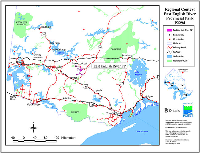
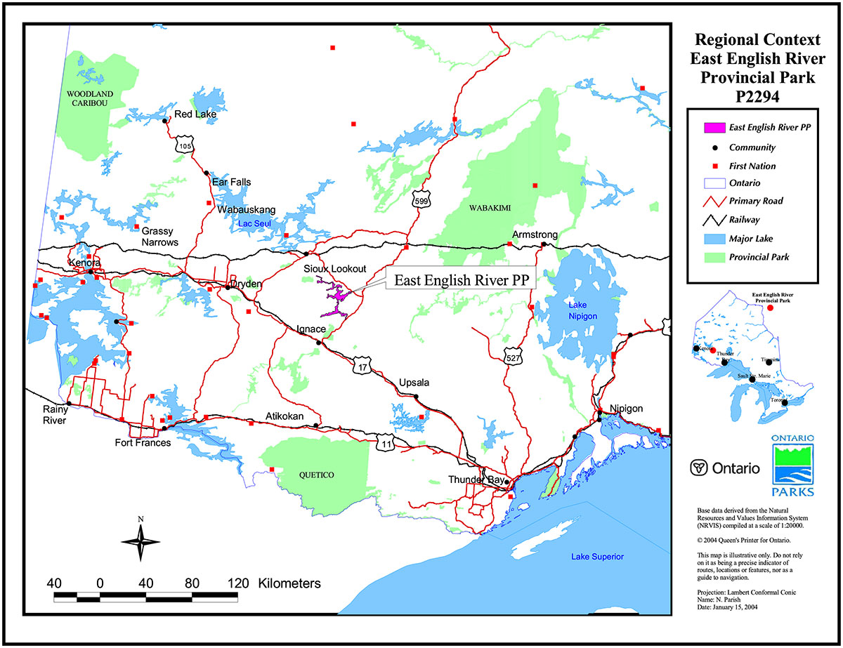
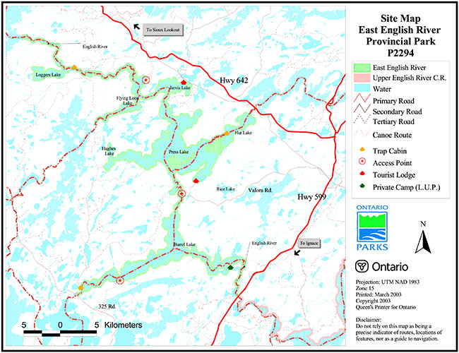
A regional context map and a site map are attached at the back of this document.
Life science representation
Landform/vegetation representation analysis
A representation analysis (Lipsett-Moore et.al., in prep.; Harris and Foster 2003) in 2003 of the Landform/Vegetation (L/V) Classes within the ecodistricts applicable to East English River Provincial Park reveals important contributions to representation benchmarks for Ecodistrict 4S-3 and 3W-2. The park makes far fewer contributions to benchmarks in Ecodistrict 4S-5.
Ecodistrict 4S-3
The park contributes to approximately 70% (52/74) of the Ecodistrict’s L/V Classes. The following L/V types within East English River Provincial Park make an important contribution (i.e., at least 20%) to achieving L/V representation benchmarks within Ecodistrict 4S-3:
- Bedrock - Recent Burns
- Fluvial Deposits - Sparse Coniferous Forest
- Glaciofluvial Outwash - Dense Deciduous
- Glaciolacustrine Deposits – Treed Bog
- Glaciolacustrine Deposits – Recent Burns
- Glaciolacustrine Deposits – Bedrock Outcrop
- Organic Deposits – Recent Burns
- Till – Dense Deciduous Forest
Ecodistrict 4S-5
The park contributes to approximately 2.25% (18/80) of the Ecodistrict’s L/V Classes. The following L/V types within East English River Provincial Park make an important contribution (i.e., at least 20%) to achieving L/V representation benchmarks within Ecodistrict 4S-5:
- Till – Dense Deciduous Forest
- Till – Mixed Forest – Mainly Deciduous
Ecodistrict 3W-2
The park contributes to approximately 53% (44/83) of the Ecodistrict’s L/V Classes. The following L/V types within East English River Provincial Park make an important contribution (i.e., at least 20%) to achieving L/V representation benchmarks within Ecodistrict 3W-2
- Glaciolacustrine Deposits – Treed Fen
- Glaciolacustrine Deposits – Treed Bog
- Glaciolacustrine Deposits – Dense Coniferous Forest
- Glaciolacustrine Deposits – Mixed Forest (mainly deciduous)
- Glaciolacustrine Deposits – Mixed Forest (mainly conifer)
- Glaciolacustrine Deposits – Sparse Coniferous Forest
- Glaciolacustrine Deposits – Sparse Deciduous Forest
- Glaciolacustrine Deposits – Bedrock Outcrop
Species / communities
Flora and Fauna typical of southern boreal forest with elements of the Great Lakes-St. Lawrence forest.
Ecosites representing a large proportion of East English River Provincial Park are:
- ES21 (Spruce- Fir Mixedwood: Coarse Loamy Soil) (22%)
- ES26 (Spruce-Pine/Feathermoss: Fresh, Fine Loamy – Clayey Soil) (15%)
- ES19 (Hardwood-Fir-Spruce Mixedwood: Sandy- Course Loamy Soil) (14%)
ES = Ecosites (Racey et al. 1996)
Significant flora and fauna
Provincially rare plant species include:
- Fir Clubmoss (Hyperzia selago)
- Interior Rush (Juncus interior)
Provincially Rare Faunal Species include:
- Bald Eagle (Haliaeetus leucocephalus)
- Delicate Emerald (Somatochlora franklini)
- Rusty Snaketail (Ophiogomphus rupinsulensis)
Significant communities
- The English River – one of the few large river systems (upstream of Minnitaki Lake) in northwestern Ontario with a natural flow regime
- Anizev Creek Marsh – mouth of the creek supports a rich diversity of emergent and submergent vegetation
Earth science representation
Geological theme
Bedrock geology
- Archean Age Wabigoon Subprovince
Surficial geology
- Pleistocene Age surficial deposits (glacial and post glacial
Feature(s)
- Glaciolacustrine plains
- Shallow ground moraine
- Glaciofluvial deposits including outwash plains, eskers, ice contact deltas and kames
- Alluvial deposits
Cultural resource representation
- Environmental Shield
- Northern Hunters and Fishers
- Fur Trade and Fur Trading Communities
- Forest Industry & Forest Industry Communities
Theme segment
- Frontiersman Archaic
- Peoples of the Black Duck Zone
- Northwestern Ontario Pulp and Paper
Recreational opportunities
Day use
- Angling
- Hunting
- Nature Appreciation
- Cultural/Historical Viewing
Car camping
NA
Wilderness / backcountry
- Canoeing/ camping
- Angling
- Hunting
Inventories
| Level / type | Reconnaissance? - Completion date |
Detailed? - Completion date |
Required? |
|---|---|---|---|
| Earth science | Yes (2003) | No | Yes |
| Life science | No | Yes (2003) | No |
| Cultural | No | No | Yes |
| Recreational | No | Yes (2003) | No |
| Other | N/A | N/A | N/A |
I. Introduction
East English River Provincial Park (P2294) was established as part of Ontario’s Living Legacy, a land use strategy that guides the planning and management of Crown lands in central and portions of northern Ontario. Under this strategy, released July 1999, 378 new protected areas were identified. East English River Provincial Park is part of this significant expansion of Ontario’s protected areas system.
East English River Provincial Park is designated a Waterway class park in recognition of its representative natural features and high quality recreational water route. The 17,513 ha park is located approximately 20 km north of Ignace and 40 km southeast of Sioux Lookout. East English River Provincial Park is made up of numerous large lakes linked by the English River beginning at the junction of Highway 599, continuing north and terminating at Minnitaki Lake.
II. Land tenure/acquisition/disposition
East English River Provincial Park is located on Crown Land with a few exceptions. One Land Use Permit (LUP) has been issued for a private recreation camp owner on English River between Barrel Lake and Highway 599 and there are a few small parcels of patent land within the park boundary on Loggers Lake, Jarvis Lake, Hut Lake and Press Lake.
There are no patent mining claims within the East English River Provincial Park boundaries.
Guideline:
- No land disposition for the private use of individuals or corporations will be considered within the park
- Dispositions for uses associated with activities permitted in this IMS will be considered. New land disposition for commercial use may be considered in the form of land use permit or lease, provided that the proposed commercial use is consistent with conditions of the PPCRA and the project has been approved through an Environmental Assessment process.
- The existing private recreation camp may be eligible for enhanced tenure, but not purchase of land, once the decision has been screened
III. Aboriginal interests
East English River Provincial Park lies within the Treaty 3 area. The closest First Nation communities include: Saugeen First Nation (70 km northeast), Wabigoon Lake Ojibway First Nation (80 km southwest), and Lac Seul First Nation (40 km northwest). There are no existing land claims within the Park.
Guideline:
- Any management guidelines will reflect the Ontario government’s approach to aboriginal rights:
- All decisions related to the identification, planning or disposition of provincial parklands, or other lands set aside to protect significant natural or cultural heritage values, will be the subject of public consultation. Aboriginal peoples who identify traditional ties to those lands will be integral to the consultation and decision making processes. In some cases, there may be a need for separate consultation or negotiation processes to address Aboriginal interest in parklands. If required, some issues regarding how a park is used may also be the subjects of negotiation with Aboriginal people
- The Government of Ontario will consider all the available options when seeking to determine the land component, if any, during negotiations involving land claim settlements with First Nations. Options for uses that involve lands that are not to be considered for provincial park purposes will be preferred
- As described in the Province’s Interim Enforcement Policy (1991), aboriginal people hunting or fishing in provincial parks will be subject to all relevant treaties and laws. However, an agreement reached between the Province and a First Nation may modify the application of those treaties and laws (Ontario Provincial Parks: Planning and Management Policies, 1992)
IV. Natural resource stewardship
Lands and waters
East English River Provincial Park is comprised mainly of large interconnected lakes. There are six lakes entirely encompassed by the park boundary linked by the English River including Barrel, Press, Hut, Hughes, Flying Loon and Loggers Lakes. Jarvis Lake lies partially within Park boundaries. Other waterbodies within the Park include: the Agimak River between Indian and Barrel lakes, Wintering River on Press Lake, Basket River on Flying Loon Lake, and a section of the Grassy River in between Press and Hut Lakes, and of course, the English River itself.
Perhaps one of the most unique features of East English River Provincial Park is the fact that it is not regulated by dams and has no upstream point source of pollution (Harris and Foster 2002). There are over 30 sets of rapids in East English River Provincial Park. There is a major drop (42 m) in elevation between Jarvis and Minnitaki Lakes that includes several sets of rapids. "Flows peak in late May (117 m3/sec), decline through the summer and then reach a second peak in late October. Water levels decline through the winter with minimum flow (28 m3/sec) in early April". (Harris and Foster 2002, p.10)
"The terrain (in East English River Provincial Park) is generally flat. Glaciolacustrine plains with clay and silt soil make up about half of the Park. Ground moraine and glaciofluvial landforms with sandy and coarse loamy soils make up the balance. Glaciofluvial deposits are common and are oriented in a northeast to southwest direction. Features include outwash plains, esker, ice contact deltas, and kames, generally made up of sorted sand and gravel. A prominent esker crosses the English River at the north end of Barrel Lake" (Harris and Foster 2002, pp .ii & 6).
There are no mining claims within East English River Provincial Park.
Guideline:
- Aggregate extraction is not permitted
- Peat extraction is not permitted
- Commercial hydro development is not permitted
- Water control structures are permitted in certain zones in waterway class parks to perpetuate natural and cultural values or to enhance recreational opportunities. The need for any water control structures will be determined in the park management plan
- Mineral exploration and mining are not permitted within East English River Provincial Park
Vegetation management
"The vegetation in East English River Provincial Park is typical of the southern boreal forest in northwestern Ontario (with elements of the Great Lakes-St. Lawrence Forest Region) . A total of 269 vascular plant species were discovered during fieldwork. Elements of the Great Lakes-St. Lawrence forest region include red and white pine and wild black current. Prairie species found further west in Ecoregion 4S are generally absent. Rare (provincially) species include fir clubmoss (Hyperzia selago) and interior rush (Juncus interior)" (Harris and Foster 2002, p.ii).
East English River Provincial Park: contains the following representative Ecosite (ES) types (Racey et al. 1996):
- ES11-12 (Very Shallow Soils)
- ES13-23 (Sandy-Coarse Loamy Soils)
- ES25-33 (Fine Loamy-Clayey Soils)
- ES34-38 (Treed Wetlands)
- ES40-50 (Open Wetlands)
East English River Provincial Park lies entirely within the English River Forest which is licensed to Bowater under the Sustainable Forestry License #542454. Cutover areas surround the park. Logging operations have been taking place in the area since the turn of the 20th Century.
Large fires affecting the forests of the park were recorded in 1936, 1961,1976, and 1995. A large blowdown event was recorded in 1991 affecting the area between Flying Loon Lake and Press Lake to the west and the area between Jarvis Lake and Press Lake to the east.
Several wild rice marshes exist within the park boundaries.
Guideline:
- Commercial forest operations are not permitted
- Fuelwood cutting is not permitted
- Insect/disease suppression of non-native infestations is permitted
- In the absence of a Fire Management Plan for the park, the fire management objectives of the surrounding fire management zone will apply. All human-caused fires will be suppressed
- The need for a Vegetation Management Plan, which will include prescriptions for fire management, will be determined in the park management plan
- Suppression of non-native insect/disease infestations is permitted
- Ontario Parks will act as a plan advisor and reviewer during the Forest Management Planning Process, according to the northwest zone’s protocol for Ontario Parks' participation in forest management planning. This process ensures that park values and park-related values are recognized and that protection and mitigation measures are worked out through the development of the forest management plan when these values are potentially affected by adjacent forestry operations
Wildlife management
Harris and Foster (2002) found the wildlife of East English River Provincial Park to be typical of the southern boreal forest. They noted 14 species of mammals (including white tailed deer, moose, black bear, and timber wolf), 81 species of birds (including common loon, and osprey), 4 amphibians, 2 reptiles, 21 fish, and 16 odonates (dragonflies and damselflies) in the Park. Three (3) provincially rare faunal species found in the park include:
- Bald Eagle (Haliaeetus leucocephalus)
- Delicate Emerald (Somatochlora franklini)
- Rusty Snaketail (Ophiogomphus rupinsulensis)
East English River Provincial Park lies within two (2) wildlife management units (WMU #5 and #15A). Both WMU's have hunting seasons for moose, black bear, ruffed grouse, snowshoe hare, and migratory birds. There is a hunting season for white tailed deer in WMU #5 and one is being considered for WMU #15A. Ten (10) registered commercial traplines intersect the park.
Guideline:
- Non-invasive wildlife monitoring may be permitted
- Measures to ensure the protection of all significant natural features may be taken. The need for a Wildlife Management Plan will be resolved in the park management plan
- Sport hunting is permitted, subject to the relevant Ontario Hunting Regulations. Consideration of safety and conservation with respect to hunting will be made during park management planning with public involvement
- Commercial fur harvesting activities are addressed in Section VII
- Aboriginal and Treaty rights to hunt are not affected.
Fisheries management
Sport fishing is outstanding within the park. At least twenty-one (21) fish species are known to inhabit the park including, walleye, northern pike, yellow perch, lake whitefish, and smallmouth bass. Lake trout is not a target species in the park although it is common in nearby lakes.
Guideline:
- Non-invasive fisheries monitoring may be permitted. The need for a Fisheries Management Plan will be resolved in the park management plan
- Sport fishing is permitted subject to the relevant Ontario Sport Fishing Regulations. Restrictions on sport fishing may be imposed through park management planning
- In accordance with Ontario Provincial Parks Planning and Management Policies (1992), live baitfish should not be used or possessed in this provincial park. Until such time as a regulation is established, Ontario Parks will discourage the use or possession of baitfish in East English River Provincial Park
- Fish stocking of native species is permitted but stocking of non-native species is prohibited
- Aboriginal and Treaty rights to fish are not affected by the designation of East English River Provincial Park
V. Cultural resources
There are 19 registered archeological sites within East English River Provincial Park.
Although East English River Provincial Park likely did not constitute a major prehistoric travel route, there is evidence suggesting there was limited use in the area by Archaic and Blackduck cultures (Reid and Ross 1981). The Archaic period roughly constitutes the period of time between 7000 years ago and 2500 years ago. The Archaic people were hunters, fishers and gatherers and differed from the earlier Paleo-Indian culture in that they exploited a wider variety of game species. Knowledge of pottery is associated with the Terminal Woodland Period with which the more recent Blackduck culture is associated. Blackduck culture dates back to the period between 500 and 700 A.D. There is an assumption that these were the ancestors of the Native tribes who inhabited the region at the time of European contact (Reid and Ross 1981).
Pictographs are located at several locations within the Park boundaries however little is understood about the meaning and significance of these intriguing rock paintings. Archaeologists have been unable to accurately age pictographs, however some of the paintings depict features like guns and horses that indicate they were drawn after the arrival of Europeans to the area. Dewdney and Kidd (1962) postulated that most of the pictographs date back to Woodland Culture based on the assumption that older paintings would not have been able to withstand the years of severe weathering.
A system of old logging roads surrounding most of Barrel, Press, Jarvis and Flying Loon Lakes, is reminiscent of the extensive logging that occurred in the area over the past 100 years. Remnants of historical logging operations are still visible throughout the Park.
There was a Prisoner of War Camp on Press Lake during WWII and a commercial Fishery operated on Barrel Lake in the 1900's (Barr and Dyck 1979).
Guideline:
- Further inventory is required to assess the cultural resources of the park. Approved archeological fieldwork will be encouraged
- The locations of any archeological sites will not be public information. Necessary measures (access/development restrictions) to protect the integrity of any archeological sites will be implemented
- The need for a Cultural Resources Plan/Strategy for cultural features/sensitive areas will be determined through consultation and cooperation with First Nations communities and park management planning
VI. Existing/proposed development
Existing development within East English River Provincial Park is limited to a network of old logging roads currently being used as a means to access the park.
Guideline:
- Existing tourism facilities and related activities will remain subject to park management planning
- New tourism facilities may be considered only through park management planning
- Unorganized camping areas at existing access points can continue in accordance with the regulations laid out in the Provincial Parks Act, but will not be expanded. Development of new campgrounds will be addressed via park management planning
- Backcountry campsites can be maintained. New sites will be identified via park management planning
- Future road crossings for forestry operations outside park boundaries may be permitted, subject to provisions of the Environmental Assessment Act, through forest management planning
- Development of access zones will be addressed via park management planning
- Maintenance of existing roads to current standards is permitted
VII. Recreation activities
East English River Provincial Park provides excellent outdoor recreational opportunities in northwestern Ontario. The activity attraction capability which takes into account both the quality and accessibility of recreation features was rated as "High" in the Recreation Resource Inventory completed in 2002/2003. The area is easily accessed and has a complement of unique features that attract a variety of outdoor enthusiasts. The Recreation Resource Inventory (Barry and Parish 2003) outlined numerous recreational activities currently being carried out in East English River Provincial Park with sport fishing being the top rated activity. Other important activities identified during the inventory were camping, boating, hunting, canoeing, swimming, cultural, historical, and scenic viewing. Three (3) recreational canoe routes lead canoeists through portions of the park.
Guideline:
- Park management planning will determine policies for recreation management, including camping and boating and aircraft landing
- Motorized land vehicles, aircraft and watercraft (private and commercial) may be restricted in certain park zones, subject to park management planning. Motor size restrictions may be imposed, subject to park management planning
- The use of ATVs and snowmachines will be determined through park management planning
- Self-guided nature appreciation and wildlife observation is permitted
- No new boat caches are to be established for the private use of individuals
- Sport fishing and hunting are addressed in Section IV – Natural Resources Stewardship
VIII. Commercial activities
There are ten (10) commercial traplines (IG –28, IG-29, IG-30, IG-35, IG-36, IG-37, IG-48, SL-19, SL- 20, SL-21) and twelve (12) Bear Management Areas (BMA's) (IG-15A-004, IG-15A-006, IG-15A-008, IG-15A-009, IG-15A-011, SL-05-116, SL-05-117, SL-05-124, SL-05-126, SL-15A-054, SL-15A-055, SL-15A-056) intersecting East English River Provincial Park. Three (3) trap cabins are found within the park.
East English River Provincial Park is entirely within the English River Forest, which is managed by Bowater under the Sustainable Forestry License #542454.
The Park is rich in wild rice fields. The wild rice field on Press Lake is periodically harvested (under license) in conjunction with a much larger area on nearby Rice Lake.
Parts of nine (9) baitfish blocks exist within the park.
One (1) outpost camp is located on patent land on Logger’s Lake. Three (2) tourist lodges are located just outside the park boundaries. They are located on Press Lake and the English River and carry out operations within the park boundaries.
There are seventeen (17) commercial boat caches in the park and six (6) private caches.
There are no mining claims within the park boundaries.
Guideline:
- Existing tourism facilities can continue subject to management prescriptions determined through management planning
- New tourism facilities may be considered through the park management planning process
- Sport hunting can continue in East English River Provincial Park. Restrictions on hunting will be determined through park management planning
- Commercial bear hunting will be allowed to continue in areas of the park where it has traditionally occurred. When a management plan is approved, any hunting that is occurring in a nature reserve zone will be addressed through the management planning process consistent with OLL-LUS and Park Policies
- In situations where licenses have not been issued and inventories have been completed that identify candidate or probable nature reserve zones, licensing should not be issued for these areas
- No new commercial bear hunting operations will be permitted
- The issuance of licenses or permits for commercial trapping will be allowed where the activity has been licensed or permitted since January1, 1992 unless:
- The government has taken action to discontinue the activity
- Proceeding would create/aggravate resource sustainability issues (e.g., wildlife management reasons, impacts on values in nature reserve zones) or
- Licensing or permitting should be deferred due to Aboriginal issues
- Status Indians exercising treaty rights are permitted to continue trapping, subject to applicable legislation and regulation
- Snowmachine trails used for access to trap lines are permitted
- No new commercial fur harvesting operations will be permitted, including new cabins and trails. The relocation of existing trails will be subject to ecological principles and park management planning
- Snowmachine trails used for access to trap lines are permitted
- The issuance of licenses for baitfish harvesting will be allowed where the activity has been licensed or permitted since January 1, 1992 unless:
- The government has taken action to discontinue the activity
- Proceeding would create/aggravate resource sustainability issues (e., wildlife management reasons, impacts on values in nature reserve zones) or
- Licensing or permitting should be deferred due to Aboriginal issues
- Existing baitfish harvesting is permitted to continue indefinitely, subject to possible conditions identified in subsequent Provincial Park and/or Fisheries Management Plans. Active licenses may be transferred where it is an established permitted use
- No new bait harvesting licenses will be permitted
- The issuance of licenses for commercial fishing will be allowed where the activity has been licensed or permitted since January1, 1992 unless:
- The government has taken action to discontinue the activity
- Proceeding would create/aggravate resource sustainability issues (e.g., wildlife management reasons, impacts on values in nature reserve zones) or
- Licensing or permitting should be deferred due to Aboriginal issues
- No new commercial wild rice harvesting is permitted. Existing authorized commercial wild rice harvest activities can continue
- Aboriginal and Treaty rights to harvest wild rice are not affected
- Ontario Parks may provide tenure for a utility corridor to accommodate the development of the new Wataynikaneyap electrical transmission line, and reinforce existing lines to Pickle Lake subject to completion of an Environmental Assessment, approval by the Minister, and any conditions necessary to protect park values
IX. Access
A substantial network of old logging roads provide informal access to East English River Provincial Park in several remote locations indicated on the attached map. The busiest access points are located at the junction of the English River and Highway 599 and at Barrel Lake located north of Ignace off the 325 Road. The access point at Flying Loon Lake is showing signs of overuse (e.g., garbage, ruts in the road). Overnight camping regularly occurs at the Barrel Lake access point.
Guideline:
- Access into the park from traditionally used roads will be permitted to continue pending park management planning. No new access to the park will be created from adjacent roads until resolved via park management planning
- Decisions on new roads, parking facilities and long-term management of roads abutting / crossing parklands will be clarified via park management planning when access zones are delineated. New roads abutting the park are determined during forest management planning, reflecting the need to harmonize the English River Forest Management Plan (FMP) with the direction given in Ontario Park Policy, the Ontario’s Living Legacy Land Use Strategy, this Interim Management Statement and future park management plans
- One new road crossing between Jarvis and Flying Loon Lake for forestry purposes may be permitted where alternatives that do not cross the park are determined to be unacceptable through forest management planning. Additional future road crossings will be subject to forest management planning and park management planning
- Access by Aboriginal people exercising their Aboriginal or Treaty rights is not affected
X. Client services
Guideline:
- Client services will be limited to a map/brochure until an approved park management plan is completed
XI. Research and inventories
Detailed life science and recreation resource inventories were completed in 2002/03.
Guideline:
- Detailed earth science, life science, cultural and recreation values inventories will be undertaken when funding permits
- Additional research / inventories to document park values will be permitted if not in conflict with park values and consistent with the Ontario Parks Research and Information Strategy
- MNR, Ontario Parks or partnered groups and individuals may undertake research projects. The Park Superintendent/Zone Manager must approve all research applications
XII. Marketing
Marketing of East English River Provincial Park has been limited to the acknowledgement of its role in the Ontario’s Living Legacy Land Use Strategy and the provincial parks and protected areas system.
Guideline:
- A park management plan may direct that a Marketing Strategy be developed. The scope of this plan would include provincial, national, and international markets
XIII. Sources/references
Barr,E. and Dyck, B. 1979. Ignace: a Saga of the Shield. Winnipeg: The Prairie Publishing Co.
Barry, Janice and Parish, N. 2003 Recreation Resource Inventory – East English River Provincial Park. Ontario Parks, Unpublished Report.
Dewdney, S. and Kidd, K.E., 1962. Indian Rock Paintings of the Great Lakes. Toronto: University of Toronto Press.
Harris, A. and Foster, R. 2002. Life Science Inventory – East English River Provincial Park –Draft. Unpublished report.
Lipsett-Moore, G., Bookey, N., Kingston, S. and J. Shuter. In Prep. Representation, Focal Species and Systematic Conservation Planning for the Northern Boreal Initiative. Ontario Parks, Northwest Zone.
Ontario Ministry of Natural Resources (OMNR). 1999. Ontario’s Living Legacy Land Use Strategy.
Ontario Ministry of Natural Resources (OMNR). 1992 Ontario Provincial Parks: Planning and Management Policies.
Ontario Ministry of Natural Resources (OMNR). 2001. Natural Resource Values Information System (NRVIS). Dryden and Fort Frances Districts.
Ontario Ministry of Natural Resources (OMNR). 1983. Ignace District Land Use Guidelines (DLUG).
Racey, G.D., Harris, A.G., Jeglum, J.K., Foster, R.F. and G.M. Wickware 1996. Terrestrial and Wetland Ecosites of Northwestern Ontario. Queen’s Printer for Ontario, Thunder Bay.
Reid, C.S. and Ross, W.A. 1981. Studies in West Patricia Archaeology No. 2: 1979-1980. Historical Planning and Research Branch. Ontario Ministry of Culture and Recreation.
Appendix I: Summary of involvement
In May 2019, this management statement was amended to allow for a hydro line crossing. On July 10, 2017, a policy proposal notice was posted on the Environmental Registry for the review of the proposed amendments. The comment period occurred between July 10 – August 24, 2017. Letters were also sent to Indigenous communities and other interested or affected stakeholders to notify, and request input, on the proposed amendments to park management direction. One comment was received.
Appendix II: Permitted uses table for East English River Provincial Park
Commercial activities
| Activity | Permitted? | Guidelines |
|---|---|---|
| Aggregate extraction | No | |
| Bait fishing (commercial) – existing | Yes | The issuance of licenses for baitfish harvesting will be allowed where the activity has been licensed or permitted since January1, 1992 unless:
|
| Bait fishing (commercial) – new | No | |
| Commercial fishing – existing | Yes | No commercial fishing operations currently exist within the park. The issuance of licenses for commercial fishing will be allowed where the activity has been licensed or permitted since January1, 1992 unless:
|
| Commercial fishing – new | No | |
| Commercial fur harvest – existing | Yes | Existing trap line operations can continue indefinitely. New operations, including trap line cabins and trails will not be permitted. The relocation of existing trails and cabins will be subject to ecological principles and management planning. Snowmobile trails used for access to the trap lines are permitted.
In situations where licenses have not been issued and inventories have been completed that identify candidate or probable nature reserve zones, licensing should not be issued for these areas. Existing commercial bear hunting operations are permitted to continue but the introduction of new operations will not be allowed. |
| Commercial fur harvest – new | No | |
| Commercial hydro development | No | |
| Commercial timber harvest | No | |
| Commercial Tourism (e.g. outfitting services, outpost camps, resorts/lodges) – existing | Yes | Existing authorized facilities/operations are permitted to continue, subject to management prescriptions determined through planning. Existing tourism facilities may be eligible for enhanced tenure as decided through planning. |
| Commercial Tourism (e.g. outfitting services, outpost camps, resorts/lodges) – new | Maybe | New facilities/operations may be considered through planning. |
| Energy transmission & communications corridors (new) | Maybe | Utility line crossings may be necessary to maintain essential public services. The number of new crossings will be minimized where possible and they will be managed to reduce their impact on recreational and aesthetic values. |
| Mineral exploration and development | No | |
| Commercial Wild rice harvesting – existing | Yes | |
| Commercial Wild rice harvesting – new | No |
Land and resource management activities
| Activity | Permitted? | Guidelines |
|---|---|---|
| Crown land disposition – private use | No | No land disposition for the private use of individuals is permitted, except for minor dispositions in support of existing uses (e.g., reconstruction of a septic system). All existing tenure issued by the Crown for private use will be phased out no later than January1, 2010. |
| Crown land disposition – commercial use | Maybe | Land disposition for commercial use may occur, under the authority of a land use permit or lease, subject to approval through planning. Existing tourism facilities may be eligible for enhanced tenure. |
| Fire suppression | Maybe | In the absence of a fire management plan for the park, the fire management objectives of the surrounding fire management zone will apply. All human-caused fires will be suppressed. |
| Fish habitat management | Maybe | May be considered through planning. |
| Fish stocking – native species | Maybe | May be considered through planning. |
| Fish stocking – non-native species | No | |
| Insect/disease suppression | Maybe | May be considered through planning. |
| Inventory/monitoring | Yes | |
| Personal use permits for wood harvesting | Maybe | Long-term management direction will be determined through planning. Existing authorized permits may continue on an interim basis for properties that do not have road access. |
| Prescribed burning | Maybe | May be considered through planning. |
| Roads (non-park use) - existing | Maybe | Access into the park from traditionally used roads will be permitted to continue pending park management planning. No new access to the park will be created from adjacent roads until resolved via park management planning. Existing road crossings for forest management purposes are permitted. Conditions of use will be addressed in park management planning and forest management planning. |
| Roads (non-park use) - new | Maybe | New roads abutting the park are determined during forest management planning No new access to the park will be created from adjacent roads until resolved via park management planning. Future road crossings for forestry operations outside park boundaries may be permitted, subject to provisions of the Environmental Assessment Act including park management planning and forest management planning. The number of crossings will be minimized where possible and they will be managed to reduce their impact on recreational and aesthetic values. One new road crossing between Jarvis and Flying Loon Lake for forestry purposes may be permitted where alternatives that do not cross the park are determined to be unacceptable through forest management planning. Additional future road crossings will be subject to forest management planning and park management planning. |
| Vegetation management | Maybe | May be considered through planning. |
| Water control structure –existing | Maybe | No structures exist. |
| Water control structure – new | Maybe | New structures may be considered through planning for recreation enhancement. |
| Wildlife population management | Maybe | May be considered through planning. |
Science, education and heritage appreciation
| Activity | Permitted? | Guidelines |
|---|---|---|
| Demonstration areas | Maybe | May be considered through planning. |
| Historical appreciation- self-guided | Maybe | Support facilities to be identified through planning. |
| Nature appreciation – self-guided | Maybe | Support facilities to be identified through planning. |
| Photography and painting | Maybe | Support facilities to be identified through planning. |
| Research | Yes | Subject to authorization. |
| Wildlife viewing | Maybe | Support facilities to be identified through planning. |
Recreation activities and facilities
| Activity | Permitted? | Guidelines |
|---|---|---|
| Aircraft landing (water) | Maybe | Under the authority of a valid aircraft landing authorization, as per O. Reg. 952/01, s. 24(2) under the Provincial Parks Act. |
| ATV use – on trails | Yes | Existing ATV use on authorized trails can continue, subject to management prescriptions determined through park management planning. |
| ATV use – off trails | No | |
| Camping | Maybe | Long-term management direction for camping facilities will be determined through park management planning. Existing use may continue in the interim, unless park values are threatened. |
| Horseback riding (trail) | Maybe | Long-term management direction will be determined through planning. Existing use may continue in the interim, unless park values are threatened. No authorized trails exist. |
| Hunting | Yes | Subject to regulation under the Fish and Wildlife Conservation Act. Consult the Ontario Hunting Regulation Summary for specific local details. Hunting may be restricted in certain zones as determined through park management planning. |
| Mountain bike use | Maybe | Long-term management direction will be determined through planning. No authorized trails exist |
| Motor boat use – private | Maybe | Long-term management direction for private motor boat use will be determined through management planning. Existing use may continue in the interim, unless park values are threatened. Consult regulations under the Provincial Parks Act for specific local details. |
| Motor boat use – commercial | Maybe | Long-term management direction for commercial motor boat use will be determined through management planning. Existing use may continue in the interim, unless park values are threatened. Consult regulations under the Provincial Parks Act for specific local details. |
| Non-motorized recreation travel (canoeing, kayaking, hiking, cross- country skiing, snowshoeing) | Maybe | Long-term management direction will be determined through planning. Existing uses may continue in the interim, unless park values are threatened. No authorized trails for hiking or skiing exist. |
| Private recreation camps ("hunt camps") – existing | Yes | Existing authorized camps permitted to continue, eligible for enhanced tenure but not purchase of land. |
| Private recreation camps ("hunt camps") – new | No | |
| Rock climbing | Maybe | Long-term management direction will be determined through planning. Rock climbing is permitted only in areas designated for that purpose by the park superintendent as per O. Reg. 952/01, s. 5.1 under the Provincial Parks Act. No areas are currently designated. |
| Sailing and sailboarding | Maybe | Long-term management direction will be determined through planning. Existing uses may continue in the interim, unless park values are threatened. |
| Scuba and skin diving | Maybe | Long-term management direction will be determined through planning. Existing uses may continue in the interim, unless park values are threatened. |
| Snowmobiling – on trails | Maybe | Existing snowmobile use on authorized trails can continue, subject to management prescriptions determined through planning. |
| Snowmobiling – off trails | No | |
| Sport fishing | Yes | Consult the Ontario Recreational Fishing Regulations Summary for specific local details. |
| Trail development | Maybe | Certain trails may be considered through planning. |
Appendix III: Protected area maps
Figure 1: Regional context, East English River Provincial Park
Enlarge figure 1: Regional context, East English River Provincial Park
Figure 2: Site map, East English River Provincial Park
Enlarge figure 2: Site map, East English River Provincial Park
Contact us
Ministry of Natural Resources and Forestry
Dryden District
479 Government Road
P.O. Box 730
Dryden, ON
P8N 2Z4
Telephone:
Ontario Parks Northwest Zone
Suite 221D
435 James Street South
Thunder Bay, ON
P7E 6S8
Telephone: