East Sister Island Provincial Park Management Plan
This document provides direction on the management of East Sister Island Provincial Park.
© 2009, Queen’s Printer for Ontario
Printed in Ontario, Canada
Additional copies of this publication are obtainable from:
Wheatley Provincial Park
P.O. Box 640
Wheatley, Ontario N0P 2P0
Telephone:
51924
(0.1k P.R., 09 04 24)
ISBN 978-1-4249-7029-2 (Print)
ISBN 978-1-4249-7030-8 (PDF)
Dear Sir or Madam:
I am pleased to approve the East Sister Island Park Management Plan as Ontario Parks' policy for the protection and management of this park. This plan is consistent with the requirements of the Provincial Parks and Conservation Reserves Act and reflects the Ministry of Natural Resources' and Ontario Parks' commitment to manage East Sister Island for the people of Ontario as a nature reserve class provincial park, protected from the impacts of human activity, now and in the future. The plan summarizes the consultation that occurred as part of the planning process.
The plan for East Sister Island Provincial Park (Nature Reserve Class) will be used to guide the management of the park. It may be reviewed to address changing issues or conditions.
Sincerely,
Donna Cansfield
The Honourable Donna Cansfield
Ontario Minister of Natural Resources
Date: March 30, 2009
Statement of Environmental Values and the Environmental Bill of Rights
The Ministry of Natural Resources' Statement of Environmental Values (SEV) under the Environmental Bill of Rights (EBR) describes how the purposes of the EBR are to be considered whenever decisions are made in the Ministry that might significantly affect the environment. This includes decisions made as a result of preparing management direction for a protected area.
The Ministry’s SEV has been considered throughout the planning process. The management direction for East Sister Island Provincial Park will further the objectives of managing Ontario’s resources on an environmentally sustainable basis.
Planning context
This park management plan has been prepared consistent with direction contained in Our Sustainable Future, Ministry of Natural Resources Strategic Directions (2005). This document has also been prepared consistent with direction contained in Protecting What Sustains Us: Ontario’s Biodiversity Strategy (2005). The Ministry’s vision is "sustainable development" and the Ministry’s mission is "ecological sustainability". The Ontario Parks program contributes mainly to the goal of: "Healthy Natural Environment for Ontarians", but contributes to other strategic elements as well. The mandate of the Ministry for Ontario Parks is to deliver Ontario’s parks and protected areas program, which includes: the protection and management of provincially significant natural, cultural and recreational environments; provincial parks operations; provision of tourism opportunities, natural heritage education; planning and management of parks and protected areas; policy leadership on conservation reserves; monitoring, auditing and public reporting on Ontario’s parks and protected areas.
Aboriginal context
Local Aboriginal communities include both the Caldwell First Nation and Bkwejwanong Territory (Walpole Island) First Nation. This document recognizes that Aboriginal communities may have used the area for hunting, trapping, fishing, gathering and travel. These uses may continue subject to public safety, conservation and other considerations.
Nothing in this plan shall be construed so as to abrogate or derogate from the protection provided for the existing Aboriginal or treaty rights of the Aboriginal people of Canada as recognized and affirmed in Section 35 of the Constitution Act, 1982.
1.0 Introduction
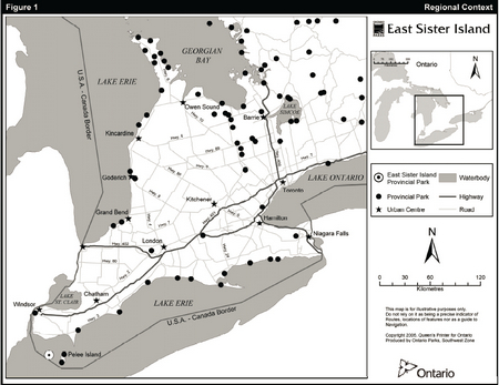
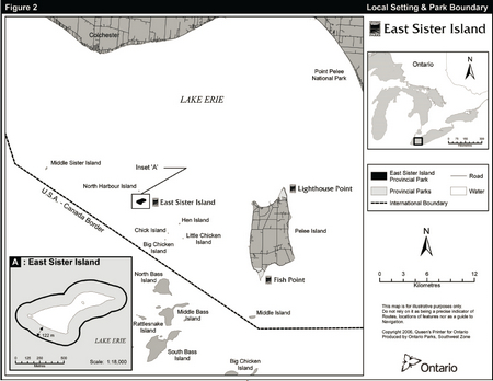
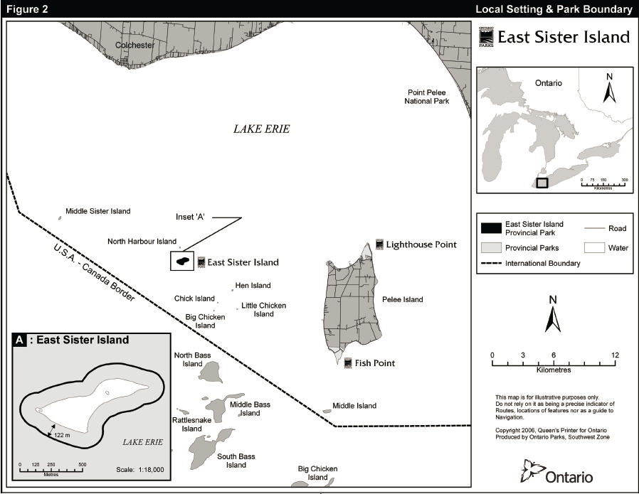
The Lake Erie Archipelago consists of a series of islands located in the western basin of the lake, mid-way between the Ontario and Ohio shorelines of Lake Erie. The Canadian portion of the Lake Erie Archipelago is comprised of nine islands, namely, East Sister Island, Pelee Island, North Harbour Island, Middle Sister Island, Middle Island, Hen Island, Little Chicken Island, Big Chicken Island and Chick Island. East Sister Island is situated about 25 kilometres south of Leamington and 13.5 kilometres due west of Pelee Island (see Figures 1 and 2). The island is nearly flat and only a few metres above lake level at its highest point.
East Sister Island was acquired by the Province of Ontario in November 1971 from a then resident of Freemont, Ohio. East Sister Island Provincial Park was regulated under the former Provincial Parks Act in 1976, with a total of 53 hectares consisting of the 15 hectare island and 38 hectares of surrounding water.
Other protected areas nearby include Lighthouse Point and Fish Point, both situated on Pelee Island and Wheatley Provincial Park near the community of Wheatley (see Figure 1). Pelee Island is also home to other protected areas including Ontario Nature’s Stone Road Alvar Nature Reserve, the Stone Road Alvar Conservation Area administered by the Essex Region Conservation Authority and Shaughnessy Cohen Memorial Savanna managed by the Essex Field Naturalists' Club. Middle Island is managed by Parks Canada as part of Point Pelee National Park, which is located near Leamington.
Accessible only by boats with shallow draft, East Sister Island has had minimal human disturbance and is most characteristic of the pre-settlement flora and fauna of the Erie Islands. Also, the combination of the island’s southern location and the moderating effects of the surrounding lake result in one of the longest growing seasons in eastern Canada with a number of plant and animal species occurring here that are rare or unknown anywhere else in the country.
2.0 Classification
Ontario’s provincial parks are organized into broad categories by park class. Each class has particular purposes and characteristics as well as distinctive planning, management and visitor services policies. Park classification defines an individual park’s role in providing opportunities for environmental protection, recreation, heritage appreciation and/or tourism. Each park shares with others in its class particular characteristics, which help determine its specific function. Classification establishes a management framework for individual parks within the provincial system. Provincial parks are divided into seven classes: wilderness, nature reserve, and cultural heritage, and natural environment, waterway, recreational and aquatic.
East Sister Island Provincial Park is classed as a nature reserve in recognition of its provincially significant life science features. Nature reserves are areas selected to protect representative ecosystems and provincially significant elements of Ontario’s natural heritage. They are protected for educational purposes, as gene pools for research to benefit present and future generations and for their intrinsic values to society. Nature reserves maintain ecological diversity and ensure the perpetuation of species, their communities and earth science features. As well as assuring their long-term viability, study of these areas can improve existing environmental management and understanding of the functioning of natural processes and their response to human impact.
3.0 Goal
The goal for East Sister Island is to protect significant and representative natural features.
East Sister Island will be managed for the people of Ontario as a nature reserve class provincial park, protected from negative impacts stemming from either human activity or natural causes, now and in the future. In keeping with Ontario’s Provincial Parks and Conservation Reserves Act (PPCRA), the following principles shall guide all aspects of planning and management:
- Maintenance of ecological integrity shall be the first priority and the restoration of ecological integrity shall be considered
- Opportunities for consultation shall be provided
Basic policy direction for the park is drawn from Ontario Provincial Parks Policy and Ontario Provincial Parks: Planning and Management Policies.
4.0 Objectives
Ontario’s protected areas system has four objectives for establishing and managing provincial parks, as stated in Ontario’s PPCRA:
- to permanently protect representative ecosystems, biodiversity and provincially significant elements of Ontario’s natural and cultural heritage and to manage these areas to ensure that ecological integrity is maintained
- to provide opportunities for ecologically sustainable outdoor recreation opportunities and encourage associated economic benefits
- to provide opportunities for residents of Ontario and visitors to increase their knowledge and appreciation of Ontario’s natural and cultural heritage; and
- to facilitate scientific research and to provide points of reference to support monitoring of ecological change on the broader landscape
As a nature reserve class provincial park, East Sister Island contributes to these objectives in the following ways.
Figure 1: Regional Context
Enlarge Figure 1: Regional Context
Figure 2: Local Setting & Park Boundary
Enlarge Figure 2: Local Setting & Park Boundary
4.1 Protection
Ontario’s protected areas play an important role in representing and conserving the diversity of Ontario’s natural features and ecosystems, across the broader landscape. Protected areas include some of the best representative examples of cultural heritage, life and earth science features within ecologically defined regions. Ontario’s 71 ecodistricts are defined by a characteristic set of physiographic features, including bedrock and/or surficial geological features and topography.
These physiographic features play a major role in determining successional pathways
Park management plans apply only to the area within the regulated boundary of the park. Within the park boundary, the protection objective will be achieved through appropriate zoning, control of land use and activities, education and monitoring of ecological impacts. Appropriate mitigation of potential impacts will contribute to the continued protection of significant features.
The protection objective for the nature reserve may be achieved through active resource management.
Consistent with Protecting What Sustains Us: Ontario’s Biodiversity Strategy, the nature reserve will be managed to protect species at risk and their habitats.
4.1.1 Life science
East Sister Island offers excellent representation of some of the distinctive natural habitats and landforms of the Carolinian Life Zone (this "life" zone represents the northern extreme of the Southern Deciduous Forest Region, which reaches south as far as the Carolinas, hence its name) and the Lake Erie Archipelago. The island is located within Ecodistrict 7E-1, described as a smooth plain of moderate lime clay broken by ridges of sand and gravel.
A swamp dominates the central part of the island. Mature mesic (moderate moisture levels) deciduous forest occurs west of the swamp. The terrain is more elevated to the east, resulting in a drier forest association.
East Sister Island is significant for its southern flora. Its forested area includes stands of black maple (Acer saccharum nigrum), Kentucky coffee-tree (Gymnocladus dioicus) and common hackberry (Celtis occidentalis).
A total of 24 provincially rare and two locally (Essex County) rare plant species have been documented on East Sister Island. Kentucky coffee-tree, a species at risk, is considered threatened in Canada and is more numerous here than elsewhere in the Erie Islands. Because of the small and isolated location of East Sister Island, the fauna complement is limited. Three mammals, 19 breeding birds, at least 10 species of butterflies, one amphibian and two notable reptiles have been recorded, namely, the threatened eastern foxsnake (Elaphe gloydi) and the endangered Lake Erie watersnake (Nerodia sipedon insularum) (Kamstra et al. 1995, Dobbyn n.d.).
In the west central part of the island, a common hackberry stand, with a significant component of Kentucky coffee-tree, provides sanctuary for a large heronry. This heronry represents a major breeding colony for great blue herons (Ardea herodias) which have nested here for decades. The island also supports black-crowned night- herons (Nycticorax nycticorax), great egrets (Casmerodius albus) and double-crested cormorants (Phalacrocorax auritus). The coastal area provides habitat for a variety of waterfowl and shorebirds. Herring gulls (Larus argentatus) nest on the rocky shoreline.
East Sister Island is part of the Pelee Island Archipelago Important Bird Area (IBA). This IBA also includes five other limestone islands, in the Canadian portion of the western basin of Lake Erie, namely, Middle Sister, North Harbour, Big Chicken, Hen and Middle. The Pelee Island Natural Area is a separate IBA. The Pelee Island Archipelago supports one of the richest assemblages of nesting colonial birds in Lake Erie. At least five bird species, including the great blue heron, black-crowned night-heron, great egret, double-crested cormorant and herring gull are present in numbers of national significance. Given the location of East Sister and the other islands in the archipelago, they are also thought to be significant as migratory bird stop-over sites.
4.1.2 Earth science
East Sister Island and adjacent islands represent the emergence from Lake Erie of two undulations on the surface of Silurian and Devonian bedrock. The island is nearly flat and only a few metres above lake level at its highest point. Glacial grooves are present on the exposed bedrock. Wave action is responsible for solution erosion of the exposed bedrock at the northwest end of the island. Elsewhere the shoreline consists of cobblestones resulting from storms and winter ice action. In 1956, Hurricane Hazel created a raised shingle berm (raised bank of beach gravel) around much of the island (Tracey et al. 1971), which remains evident to date.
Shallow soils cover parts of the island. A light brown, stony loam forms shallow deposits where limestone bedrock appears close to the surface. Brown clay deposits have been exposed by wave undercutting along the southeast shore.
The subsurface rock formations beneath East Sister Island have potential for the occurrence of commercial accumulations of oil and natural gas. Since the early 1900's, natural gas with a current value of over $3 billion has been produced from approximately 600 wells drilled on or under Lake Erie. MNR oil and gas policy does not currently permit drilling for oil under the bed of Lake Erie using offshore wells and drilling for either oil or gas is not permitted west of a straight line drawn from the tip of Point Pelee to Marble Head, Ohio. The lake bed around East Sister Island is located within this no-drill zone.
4.1.3 Cultural resources
In the early 1900s the island contained a house and several acres of peach orchards and garden crops. Old wire fencing may be evidence of past livestock grazing. Former cultivated areas were abandoned and overgrew into thickets by the 1940s.
The steamer "Case" departed Cleveland, Ohio, loaded with coal for Sandwich, Ontario, on April 30, 1917. The steamer began to take on water during a severe storm during the crossing. The captain managed to ground the sinking vessel on rocks in the lee of East Sister Island, where it caught fire and burned. The wood and metal remains of the steamer lie scattered on the lake bottom.
4.2 Knowledge and appreciation
Due to the difficulty in accessing the site and the sensitivity of the natural heritage features on East Sister Island, visitation for purposes other than approved scientific research will not be encouraged. Unstructured opportunities for increasing public knowledge and appreciation of the nature reserve’s significant natural heritage features will be provided off-site as described in Section 8.1.
4.3 Research and monitoring
Scientific research and monitoring may be conducted, as necessary, to provide information to support planning and management decisions intended to ensure the ecological sustainability of the park.
5.0 Boundary
The boundary for the nature reserve is outlined in Figure 2. No additions or deletions are contemplated at this time. Two boundary-related facts are worthy of mention. First, only 15 hectares of the 53 hectares regulated as the East Sister Island Provincial Park is terrestrial base. The balance (38 hectares) is aquatic. A water boundary extends 122 metres offshore from the island’s high water mark. The boundary only includes the Crown lake bed and not the water column.
6.0 Zoning
Lands contained within the nature reserve are zoned in accordance with their environmental qualities and required protection. In this sense, East Sister Island will be managed entirely as a nature reserve zone. This 53 hectare zone includes the significant life and earth science features of the nature reserve as well as the water boundary.
7.0 Resource management policies
East Sister Island Provincial Park will be managed in accordance with the policies set out in the Ontario Provincial Parks: Planning and Management Policies for nature reserves.
Resource management initiatives may be accomplished through partnerships and sponsorships.
An adaptive management approach will be applied to resource management activities within the nature reserve. Adaptive management allows for modification of management strategies in response to monitoring and analyzing the results of past actions and experiences.
There is occasional, uncontrolled access to the nature reserve by boaters. Human presence may be particularly disturbing to nesting colonial water birds, especially heron species. To control this problem, notices may be posted indicating that public access onto East Sister Island is prohibited at certain times of the year (e.g., from April 1 to July 31).
Temporary facilities in support of approved resource management or approved research activities may be permitted in the nature reserve.
In the interest of public safety, the park superintendent may prohibit public access to the nature reserve during approved research or resource management activities.
General resource management considerations for East Sister Island may include control of hyper- abundant, alien and/or invasive species; protection of natural values including species at risk; restoration and maintenance of biodiversity; and seasonal restriction of access to the island. Resource management decisions will be informed by relevant research and analysis.
Double-crested cormorant numbers have significantly increased throughout the Great Lakes. The number of cormorant nests on East Sister Island has increased from approximately six nests in 1981 to an average of about 5100 nests over the last seven years (Weseloh n.d.). On East Sister Island, the birds prefer large trees, including Kentucky coffee-trees, an already threatened species in Ontario. Past and ongoing monitoring will examine the extent of impacts of cormorants on the island’s ecosystem and assist in determining whether specific management activities may be deemed necessary. Such management may be carried out once the project alternatives and methods (e.g. egg oiling, nest removal, culling, etc.) have been evaluated in accordance with A Class Environmental Assessment for Provincial Parks and Conservations Reserves (Class EA PPCR).
7.1 Species at risk
Species at risk will be protected consistent with the Endangered Species Act and regulations and in accordance with applicable policies. Populations of species at risk and their habitats will be protected and opportunities for their recovery will be provided as directed in corresponding species and ecosystem recovery plans.
7.2 Fish and wildlife
Hunting and commercial trapping will not be permitted. Control of particular species may be required for public safety, protection of property and/or the perpetuation of natural values.
Commercial and sport fishing occur in Lake Erie, offshore from East Sister Island and will not be affected by this plan.
7.3 Industrial / commercial uses
The following uses are not permitted on East Sister Island:
- commercial forestry
- developing mineral interests, working mines
- extraction of sand, gravel, topsoil or peat
- extraction of salt, oil or gas
- generation of electricity
8.0 Operations policies
East Sister Island will be managed as a satellite of Wheatley Provincial Park. The operating plan for Wheatley Provincial Park will provide park staff and partners with the necessary direction to effectively manage East Sister Island. In addition to addressing the operations policies that follow, the plan will include such topics as budget, staffing, maintenance schedules, enforcement and emergency services. Wherever possible, the provisions of the plan will be consistent with the approved Ontario Provincial Parks Minimum Operating Standards and will be reviewed annually and updated as required.
8.1 Natural heritage education
The following objectives for the information component of natural heritage education for the nature reserve may be achieved through printed media and/or the Ontario Parks website:
- inform the public about the nature reserve, its features, protection and management
- instil in the public a sense of respect for the park environment
- describe the role of Ontario’s protected areas and the Ministry of Natural Resources
- provide a means for the public and stakeholders to communicate with Ontario Parks regarding park management.
8.2 Research and monitoring
Scientific research and monitoring by qualified individuals contributing to the knowledge of natural and cultural history and to environmental management will be encouraged. All research and monitoring will be conducted by, or authorized by Ontario Parks. Research projects will be administered on the basis of park policy and must meet all requirements under applicable provincial and federal legislation. Approved research and monitoring activities must be consistent with Ontario Parks' Research and Information Strategy. Temporary facilities in support of approved research and monitoring activities may be permitted in the nature reserve.
The nature reserve’s population of threatened Eastern fox snake and the endangered Lake Erie water snake have been periodically monitored.
Research and monitoring priorities include, but are not limited to:
- monitoring double-crested cormorant populations and their impacts
- monitor impacts of management activities
- monitoring populations of other colonial nesting bird species
- monitoring populations of species at risk
- studying the impacts of cormorants on the nature reserve’s vegetation
8.3 Recreation management
Due to the difficulty in accessing the site and the sensitivity of the features at East Sister Island, visitation for purposes other than scientific research will not be encouraged. Facilities for recreational boat docking and hiking will not be provided.
Prohibited activities in the nature reserve include camping and recreational hunting.
9.0 Development policies
A low-impact, ecologically sustainable management concept will be applied for East Sister Island. No development will occur aside from temporary facilities in support of research or resource management activities approved by Ontario Parks. Resource management and research activities and facilities will be compatible with protection of the nature reserve and will be subject to the nature reserve’s development and management policies. Sites altered by approved research or resource stewardship activities will be rehabilitated as closely as possible to their previous natural condition by the proponent(s).
10.0 Implementation policies
Opportunities for partnerships involving volunteers, non-government organizations or others may be explored, such as the Pelee Island Heritage Centre or Point Pelee National Park.
Implementation of the park management plan shall occur in an ecologically sustainable manner. All requirements of the Environmental Assessment Act, Environmental Bill of Rights, Provincial Parks and Conservation Reserves Act, Endangered Species Act and other pertinent legislation will be met.
All aspects of park management, development and operation will be undertaken in accordance with the requirements of the Class EA PPCR.
One or more implementation plans may be prepared for the nature reserve. Implementation plans will be prepared in accordance with the requirements of the Class EA PPCR including, consideration of alternatives, positive and negative effects, mitigation techniques and monitoring.
Preparation of implementation plans will be contingent upon the availability of funding and unforeseeable changes in priorities or park policy.
11.0 Plan amendment and review
The park management plan will be reviewed every 10 years, to confirm or revise its policies or to address new issues or changing conditions. The review may involve a reassessment of all or part of the plan, including classification, zoning, goal, objectives and all resource management, operations and development policies. An amendment can be considered to address specific issues or needs.
Ontario Parks will retain on file reference copies of relevant background information, terms of reference, preliminary park management plan, approved park management plan and any subsequent plan reviews or amendments.
12.0 Summary of public consultation
Public consultation is a very important part of the park management planning process. The four phases of the process consist of:
- Phase 1 - Terms of Reference
- Phase 2 - Background Information
- Phase 3 - Preliminary Park Management Plan
- Phase 4 - Approved Park Management Plan
Phase 1 consisted of a 45-day opportunity for the public to inspect the approved terms of reference for the park management planning process. A planning notice was inserted in local newspapers and mailed out to mandatory contacts such as local First Nations, adjacent property owners and other interested parties (78 mailings). In addition, the approved Terms of Reference was posted on the Ontario Parks' website and a policy proposal notice was posted on the Environmental Bill of Rights (EBR) Environmental Registry.
Phase 2 of the planning process provided a 45- day opportunity for the public to review relevant background information at the Wheatley Provincial Park office. A planning notice was inserted in local newspapers and also mailed out to 80 mandatory contacts such as local First Nations, adjacent property owners and other interested parties. In addition, an updated policy proposal notice was posted on the EBR Environmental Registry.
Phase 3 included the release of the approved East Sister Island Preliminary Park Management Plan. The document was posted on the Ontario Parks website. Notices were mailed out to 95 mandatory contacts such as local First Nations, adjacent property owners and other interested parties. A paid advertisement was placed in local newspapers. An updated policy proposal notice was posted on the EBR Environmental Registry. An open house scheduled in Leamington on September 23, 2006, was attended by five people. The public had a 45-day opportunity to review the approved preliminary park management plan.
All public comments forwarded to Ontario Parks during the third phase were fully considered in the preparation of the final park management plan.
Phase 4 involved the release of the approved East Sister Island Park Management Plan. The document was posted on the Ontario Parks website. Notices were mailed out to 112 mandatory contacts including local First Nations, adjacent property owners and other interested parties. A paid advertisement was placed in local newspapers and a policy decision notice was also posted on the EBR Environmental Registry.
13.0 References
Bird Studies Canada. Pelee Island Archipelago Important Bird Area Site Listing.
Campbell, C.A. 1976. Preliminary ecological report on Lighthouse Point, Fish Point and East Sister Island Nature Reserves, Essex County, Ontario. Prepared for Ontario Ministry of Natural Resources, Chatham, Ontario.
Celestino, Mary. 2002. Wildflowers of the Canadian Erie Islands. Essex County Field Naturalists' Club. Windsor.
Chapman, L.J., and D.F. Putnam. 1984. The Physiography of Southern Ontario. Third Edition, Ontario Geological Survey, Special Volume 2, Toronto.
Crins, W.J., and M.J. Oldham. 2000. Survey of Possible Double-crested Cormorant (Phalacrocorax auritus) Impacts on Rare Plant Occurrences on East Sister and Middle Islands, Lake Erie, Ontario, 15 June 2000. Unpublished draft report. Ontario Ministry of Natural Resources.
Dobbyn, S. In Prep. Changes in the vegetation communities of East Sister Island in response to Double-crested Cormorants (Phalacrocorax auritus). A summary of research findings. Ontario Ministry of Natural Resources.
Duffe, J.A. 2006. Impacts of double-crested cormorants nesting on western Lake Erie islands. Master’s thesis. Carleton University. 100pp.
Dunster, Julian, and Katherine Dunster. 1996. Dictionary of Natural Resource Management. UBC Press, Vancouver.
Harvey, E.T. 1977. East Sister Island Nature Reserve Earth Science Inventory Checklist. Ontario Ministry of Natural Resources, Division of Parks, Parks Planning Branch, Queen’s Park, Toronto.
Hebert, C.E., J. Duffe, D.V.C. Weseloh, E.M.T. Senese, and G.D. Haffner. 2005. Unique Island Habitats May be Threatened by Double-crested Cormorants. Journal of Wildlife Management. 69(1):68-76.
Kamstra, J., M.J. Oldham and P.A. Woodliffe. 1995. A Life Science Inventory and Evaluation of Six Natural Areas in the Erie Islands, Essex County, Ontario: Fish Point Provincial Nature Reserve; Lighthouse Point Provincial Nature Reserve, Stone Road Alvar Complex, Middle Point, East Sister Island Provincial Nature Reserve and Middle Island. Aylmer District (Chatham Area), Ontario Ministry of Natural Resources.
Klinkenberg, R. 1983. East Sister Island Provincial Nature Reserve Life Science Inventory Check-sheet. Ontario Ministry of Natural Resources, Division of Parks, Park Planning Branch, Queen’s Park, Toronto.
Mitchell, S. 1973. A Report on the Resources and Management of East Sister Island, Lake Erie, Ontario. Ministry of Natural Resources.
Ontario Ministry of Natural Resources. 1983. Chatham District Land Use Guidelines. Chatham District, Chatham.
Ontario Ministry of Natural Resources. 2005. A Class Environmental Assessment for Provincial Parks and Conservation Reserves. Peterborough.
Ontario Ministry of Natural Resources. 1978. Collected Plant Specimens from East Sister Island, Ontario as represented in the Herbarium of Rondeau Provincial Park. Parks Division, Chatham District.
Ontario Ministry of Natural Resources. East Sister Island Preliminary Park Management Plan. Southwest Zone, Ontario Parks, London, 2006.
Ontario Ministry of Natural Resources. 1995. Environmental Bill of Rights Procedures Manual (Working Draft). Corporate Policy and Planning Secretariat.
Ontario Ministry of Natural Resources. 1994. Ontario Provincial Parks Management Planning Manual. Provincial Operations Branch, Peterborough.
Ontario Ministry of Natural Resources. 1978. Ontario Provincial Parks: Planning and Management Policies. Parks and Recreational Areas Branch, Toronto.
Ontario Ministry of Natural Resources. 1992. Ontario Provincial Parks: Planning and Management Policies, 1992 Update. Provincial Parks and Natural Heritage Policy Branch, Toronto.
Ontario Ministry of Natural Resources. 2005. Our Sustainable Future – Ministry of Natural Resources Strategic Directions. Peterborough.
Ontario Ministry of Natural Resources. 2005. Protecting What Sustains Us: Ontario’s Biodiversity Strategy.
Ontario Ministry of Natural Resources. 1998. Review of the Population Status and Management of Double-Crested Cormorants in Ontario. Fish and Wildlife Branch, Peterborough.
Ontario Ministry of Natural Resources. 2009. Species at Risk in Ontario (SARO) List.
Tracey, A.G. Brief Geomorphology and Geology of East Sister Island. Parks Planning Branch, Division of Parks, Ontario Ministry of Natural Resources, Toronto. Earth Science Series, Open File Report 7111, 16p.
Tracey, A.G., I.D. Macdonald, and T.J. Beechey. East Sister Island, Essex County, Ontario. 1971. A natural science inventory report. Unpublished report. Parks Branch, Ontario Department of Lands and Forests.
Wachter, Georgann, and Michael Wachter. 2001. Erie Wrecks West – A Guide to the Shipwrecks of Western Lake Erie.
Weseloh, D.V., P.J. Ewins, J. Struger, P. Mineau, C.A. Bishop, S. Postupalsky, and J.P. Ludwig. 1995. Double-crested cormorant of the Great Lakes: changes in population size, breeding distribution and reproductive output between 1913 and 1991. Colonial Waterbirds 18 (Spec. Publ. 1): 48-59. Weseloh, D.V. Unpublished data.
Footnotes
- footnote[1] Back to paragraph The probable course of plant community development within a defined framework of seral (successional) stages for a particular disturbance regime (Dunster and Dunster 1996).