Englehart River Fine Sand Plain & Waterway Provincial Park Management Statement
This document provides direction on the management of Englehart River Fine Sand Plain & Waterway Provincial Park.
Englehart River Fine Sand Plain and Waterway
Interim Management Statement
2006
Approval statement
I am pleased to approve this Interim Management Statement for Englehart River Fine Sand Plan and Waterway Provincial Park. Ontario’s Living Legacy Land Use Strategy (1999) identified this area as a waterway class provincial park. This provincial park was regulated under the Provincial Parks Act in May of 2002 (O. Reg. 147/02).
This Interim Management Statement provides direction for the protection and custodial management of Englehart River Fine Sand Plan and Waterway Provincial Park.
Signed by:
Paul Bewick
Zone Manager
Northeast Zone
Ontario Parks
Date: May 26, 2006
1.0 Introduction
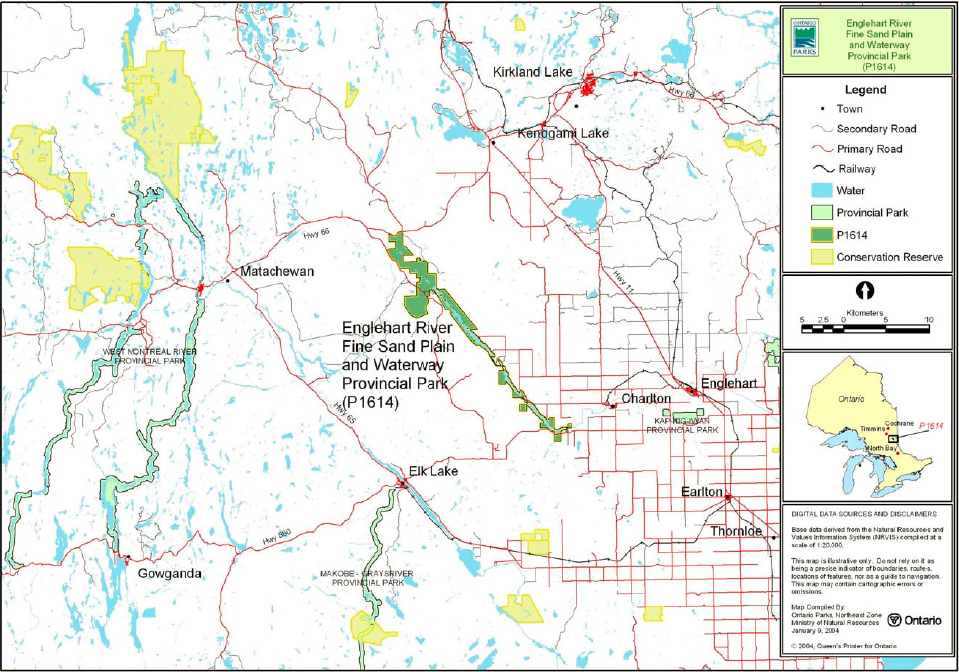
Englehart River Fine Sand Plain and Waterway Provincial Park is located approximately 48 kilometres southwest of the Town of Kirkland Lake and 20 kilometres west of the Town of Englehart (Figure 1). The park includes 4, 041 hectares of Crown land and protects a portion of the Englehart River, as well as two earth science Areas of Natural and Scientific Interest (ANSI) (Figure 2).
Englehart River Fine Sand Plain and Waterway Provincial Park was designated through the Ontario’s Living Legacy Land Use Strategy (OMNR 1999) as a waterway park. This park was regulated under the Provincial Parks Act in May of 2002 (O. Reg. #147/02). The purpose of the waterway designation is to protect outstanding recreational water routes and to provide high quality recreational and educational opportunities.
1.1 Objectives
Englehart River Fine Sand Plain and Waterway Provincial Park will be managed according to the four objectives for provincial parks:
Protection: To protect provincially significant elements of the natural and cultural landscapes of Ontario.
Recreation: To provide provincial park outdoor recreation opportunities ranging from high-intensity day-use to low-intensity wilderness experiences.
Heritage Appreciation: To provide opportunities for exploration and appreciation of the outdoor natural and cultural heritage of Ontario.
Tourism: To provide Ontario’s residents and out-of-province visitors with opportunities to discover and experience the distinctive regions of the Province.
2.0 Management context
The purpose of this Interim Management Statement (IMS) is to provide direction to ensure the custodial management of park resources. Future park planning may be undertaken as required to provide direction on significant decisions regarding resource stewardship, development, operations and permitted uses.
Park management will follow direction from:
- Provincial Parks Act (RSO 1990) and regulations
- Ontario’s Living Legacy Land Use Strategy (OMNR 1999), policy clarification amendments (OMNR 2000) and related direction
- Ontario Provincial Parks Planning and Management Policies (OMNR 1992) and updates
- Crown Land Use Policy Atlas (OMNR 2004) and amendments
Custodial management will protect park values and ensure public health and safety. Ontario Parks will ensure that policy and Environmental Assessment Act (1990) requirements are implemented.
2.1 Environmental assessment
As part of the Ontario Ministry of Natural Resources (MNR), Ontario Parks is a public sector agency that is subject to the Environmental Assessment Act. Management of this waterway park will be carried out in accordance with legislation, policies and MNR's A Class Environmental Assessment for Provincial Parks and Conservation Reserves (OMNR 2005a).
3.0 Park features and values
Englehart River Fine Sand Plain and Waterway Provincial Park contains two areas that were selected as earth science Areas of Natural and Scientific Interest (ANSI). The Teepee Creek Gap ANSI is a small canyon that is representative of the regional fault system in the area. The Kushog Lake Dune Complex ANSI is a small portion of the dune/bog complex on the Englehart River valley sand plain and represents the postglacial conditions in the glacial Lake Barlow basin (Kor 1994).
Figure 1: Regional Setting
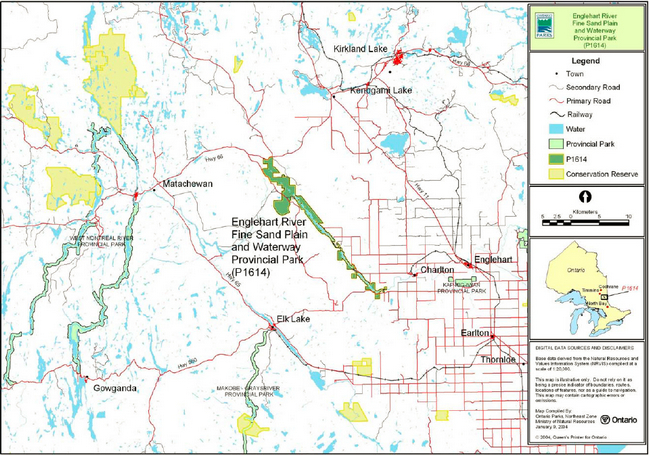
Enlarge figure 1: Regional settings
Figure 2: Park Boundary
Enlarge figure 2: Park boundary
In addition to these areas, this waterway park protects approximately 34 kilometres of the Englehart River (approximately 32 percent of the linear distance of the entire river) (Harper 2002).
3.1 Geological features
Englehart River Fine Sand Plain and Waterway Provincial Park is within the western Abitibi Subprovince, in the Archean Superior Province. The limited exposure of bedrock in the park consists of hornblende granite and tonalite of the central part of the Round Lake Batholith and small areas of mafic metavolcanic rocks of the Catherine- Pacaud supracrustal assemblage (Frey and Duba 2002).
For most of its southeastwardly flow through the park, the Englehart River occupies the surface trace of the Cross Lake Fault. The northeast facing Cross Lake Fault escarpment is the southwest boundary of the Lake Timiskaming Rift Valley, a fault-bounded structural and topographical trough. The Lake Timiskaming Rift Valley is part of an extensive crustal fracture system of the southeast Precambrian shield (Frey and Duba 2002).
The Teepee Creek Gap ANSI is a small gorge (20 metres deep) through which Teepee Creek flows into the Englehart River. This ANSI represents one of the few exposures of bedrock in the predominantly sandy banks of the river (Kor 1994). This gorge may be representative of the fault system described above.
Thin sandy ground moraine till is located in parts of the park southwest of the Englehart River. The surficial deposits of the park are mainly glaciolacustrine clays and silts east of the Englehart River and fine sand to the west of the river. These sediments were deposited when proglacial Lake Barlow flooded the area during the northward recession of the Superior Lobe of the continental ice sheet. Several linear dune ridges in the northwest of the park accumulated in the glacial Lake Barlow basin before vegetation re-established in the area (Frey and Duba 2002).
The Kushog Lake Dune Complex ANSI area of the park contains a portion of these linear dune ridges. The dunes of this area exhibit excellent form and preservation, reflect postglacial conditions in the glacial Lake Barlow basin area, and are of high interpretive and educational value (Kor 1994).
3.2 Biological features
The Teepee Creek Gap ANSI area of the park supports a mix of coniferous and intolerant hardwood species; intolerant hardwoods with pockets of mixed pine, jack pine, and other coniferous dominate along the waterway (Alkins 2003).
The Kushog Lake Dune Complex ANSI is characterized by poplar, jack pine, black spruce, and larch stands (Alkins 2003).
The Englehart River, with its associated delta and floodplain, consists of deep open water, marsh, swamp, and fen habitats. The Englehart River flows through several oxbow lakes, backwater sloughs, levee systems along the sides of the river, following a swampy river corridor and eventually flow into Long Lake (a lake complex previously known as Kushog, Kindogami and Robillard Lakes). At the southern end of Long Lake, the river narrows and continues southwards. The lower silty clay banks of the northern area of the river support shrub thickets with scattered black ash and balsam poplar, while old growth white cedar and white spruce grow on the raised banks of the river (Brownell and Blaney 1995).
Long Lake supports a cool water fishery (Alkins 2003). The fish species found in this lake include walleye, lake trout, lake herring, pike, ling, brown bullhead, smallmouth bass, yellow perch, and white sucker (Brownell & Blaney 1995). The lake trout population at Long Lake has been stocked.
3.3 Cultural setting
An investigation into the cultural features specific to Englehart River Fine Sand Plain and Waterway Provincial Park has not been completed at this time.
Any future planning will be within the context of a provincial framework, A Topical Organization of Ontario History (OMNR 1974). In addition, updates and discussions with First Nations, other agencies and stakeholders may be carried out to identify cultural heritage values and features within the park and their significance. This information may be used to develop management guidelines to conserve and protect representative archaeological and historical values and features, or to provide direction for further research.
3.4 Recreation
Englehart River Fine Sand and Waterway Provincial Park protects a portion of the Englehart River canoe route. This canoe route begins at the Englehart River Bridge on Highway 66 at the north end of the park. The route then travels south through the park and finishes at either Kap-Kig-Iwan Provincial Park (34 kilometres) or in the town of Judge (120 kilometres). This route is recommended for intermediate to advanced-level paddlers.
Other popular recreation activities in this park include fishing, hunting, boating, camping, snowmobiling, cottaging and general nature appreciation activities (Harper 2002).
The park may support educational and interpretive activities in the Teepee Creek Gap ANSI and the Kushog Lake Dune Complex ANSI.
4.0 Aboriginal uses
The park lies within the Robinson-Huron Treaty area of 1850 and is located southeast of the Matachewan Indian Reserve.
Consultation regarding the regulation of the park boundary was conducted between the MNR and the Beaverhouse Aboriginal Community, and Matachewan, Temagami and Wahgoshig First Nations (OMNR 2001).
First Nations have expressed interest in and have shared knowledge of the park and surrounding area. Aboriginal communities have used the area for hunting, trapping, fishing, gathering and travel. These uses may continue, subject to public safety, conservation and other considerations.
Any communications and cooperation between Aboriginal communities and the MNR for planning and operations purposes will be done without prejudice to any future discussions or negotiations between the government of Ontario and Aboriginal communities.
5.0 Stewardship policies
The removal, damage or defacing of Crown properties, natural objects, relics and artifacts is not permitted in provincial parks (Provincial Parks Act).
5.1 Terrestrial ecosystems
5.1.1 Vegetation
Harvesting
Commercial forest harvesting and renewal activities are not permitted within the boundaries of this park (OMNR 2004a).
The commercial harvesting of non-timber forest products (e.g. club moss, Canada yew) will not be permitted within the park.
Existing authorized wild rice harvesting may continue. New operations will not be permitted
There are no fuel wood cutting permits currently issued for the park. No new permits will be issued (OMNR 2000).
Non-native plants
Non-native plant species will not be deliberately introduced into Englehart River Fine Sand Plain and Waterway Provincial Park. Where non-native plant species are already established, and threaten park values, a strategy may be developed to control the species (OMNR 1992).
Insects and disease
Insects and diseases may be managed where the aesthetic, cultural or natural values of Englehart River Fine Sand Plain and Waterway Provincial Park are threatened (OMNR 1992).
Control measures will follow guidelines established by the Ontario Ministry of the Environment (MOE) and MNR. Biological controls, rather than chemicals, will be used whenever possible (OMNR 1992).
Fire
Englehart River Fine Sand Plain and Waterway Provincial Park is located within the Boreal Zone for forest fire management. In accordance with existing provincial park policy and the Forest Fire Management Strategy for Ontario, forest fire protection will be carried out in Englehart River Fine Sand Plain and Waterway Provincial Park as on surrounding lands (OMNR 2004b).
Whenever feasible, MNR's Forest Fire Management program will use techniques which minimize damage to the landscape, such as limiting the use of heavy equipment or limiting the number of trees felled during response efforts (OMNR 2004b).
5.1.2 Wildlife management
Englehart River Fine Sand Plain and Waterway Provincial Park is located within Wildlife Management Unit 28. The removal and harassment of non-game animals is not permitted in provincial parks (Provincial Parks Act).
Hunting
Sport hunting is permitted to continue within the boundary of Englehart River Fine Sand Plain and Waterway Provincial Park. The Fish and Wildlife Conservation Act (1997), as well as the Migratory Birds Convention Act (1994), governs any hunting activity within this provincial park. The Ontario Hunting Regulations Summary (OMNR 2005b) contains regulations specific to this area. The harvest of bullfrogs or snapping turtles is illegal in provincial parks (OMNR 2005b).
Bear management areas
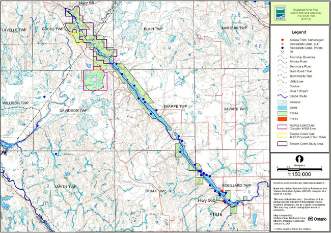
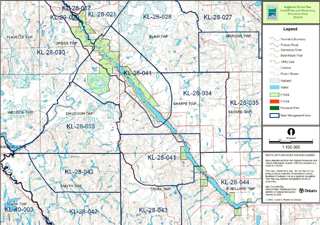
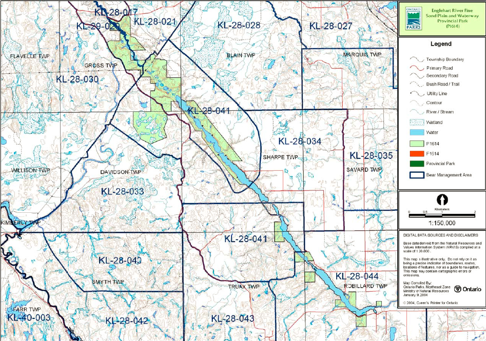
Englehart River Fine Sand Plain and Waterway Provincial Park includes portions of five active bear management areas (BMA): KL 28-034, KL 28-021, KL 29-029, KL 28-041, and KL 28-044 (Figure 3).
Existing commercial bear hunting operations are permitted to continue. This activity may be subject to conditions identified during future management planning (e.g. the designation of nature reserve zones).
New BMA licences will not be permitted (OMNR 2000; 2003).
Trapping
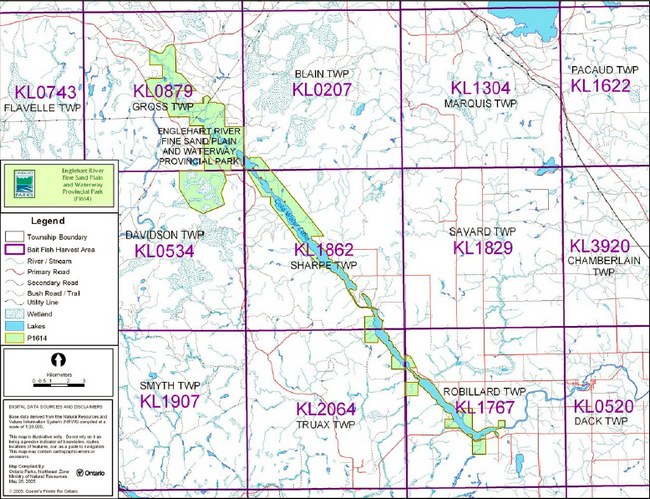
Portions of six licensed trap lines are included in the park: KL044, KL062, KL082, KL085, KL089, and KL090 (Figure 4).
Existing commercial fur harvesting operations may continue where the activity has been licensed or permitted since January 1, 1992. New operations, including trap cabins and trails, will not be permitted (OMNR 2000; 2003).
Transfers of active trap line licenses are permitted, subject to a review of potential impacts and the normal transfer or renewal conditions that apply.
Transfers include situations where a license is surrendered with a request that it be immediately reissued to another individual or organization that is assuming an existing operation. Trap cabins are considered part of a trapline and would be transferred with the trapline for the purposes of trapping. If a trapline license is revoked or surrendered, all portions of the registered line within the park will be rescinded from the legal description of the trap line (OMNR 2003).
5.1.3 Industrial resources
There are no licensed aggregate pits (active or inactive) located within the park. Aggregate extraction is not permitted (OMNR 1992).
Mineral exploration and mining are not permitted within Englehart River Fine Sand Plain and Waterway Provincial Park. In accordance with the Ontario’s Living Legacy Land Use Strategy (OMNR 1999), however, access through the park to mining lands (i.e. forest reserves and mining patents) will be permitted for purposes of mineral exploration, development or operations. Access will be planned in accordance with the requirements of the Environmental Assessment Act.
Figure 3: Bear Management Areas

Enlarge figure 3: Bear Management Areas
Figure 4: Trap Line Areas
Enlarge figure 4: Trap Line Areas
There are no existing mining claims within the park boundary. The lands within the park have been withdrawn from mining activity under the Mining Act (OMNR 1992; 2004).
5.1.4 Access and Crossings
Access
The park is accessible at various locations. Highway 66 runs along the northern boundary of the park in Gross Township and crosses the river at the Englehart River Bridge. The southern area of the park is accessible from Highway 560.
Other access points are off the secondary highway connecting Highways 66 and 560, tertiary roads branching off this highway, and concession roads south-east and east of the park.
Two unmanaged access points are located at the south end of the park in Robillard Township (Figure 2).
Roads
Highway 66 runs along the northern boundary of this park. Highway 560 is at the southern end. The corridors of these highways are not included within the park boundary.
A secondary highway connects Highway 66 and Highway 560. This secondary highway follows the western boundary and crosses the park near the Kushog Lake Dune Complex Area of Natural and Scientific Interest (ANSI).
Another secondary road runs south of Highway 66 on the east side of the park. A branch of this road travels to the utility corridor in Gross Township. The corridor of this road is not excluded from the park boundary.
There are also several tertiary roads branching off the secondary highways. Some of these roads allow for access to patent land and the waterway. The corridors of these roads are not excluded from the park boundary.
Where existing roads are essential for continued access beyond the park for forestry, recreation, or access to in-holdings and alternative road access does not exist, or road relocation is not feasible, these roads will continue to be available for access. Continued use will include maintenance and may include upgrading (OMNR 2004a). Ontario Parks is not responsible for maintenance or upgrading of any existing roads within the park boundary.
Where other existing access roads are essential for continued access to in-holdings (i.e. land use permits, patent land, etc.) within or beyond the park boundary, and alternative road access does not exist, or road relocation is not feasible, existing roads will continue to be available for access (OMNR 2004).
Crossing of waterway parks by new roads may be necessary. The number of crossings will be minimized where possible and will be managed to reduce their impact on the park’s recreational and aesthetic values. Any future road crossings proposed through the park, where park lands are unavoidable, will be reviewed on a case-by-case basis. Protection of park values will be priority and all requirements of the Environmental Assessment Act will be met.
Any proposed development, maintenance or upgrading of existing roads must meet all Environmental Assessment Act requirements. Aggregate extraction is not permitted within parks. An external source of aggregate is required for road improvements and maintenance.
Utility corridors
There is one utility corridor that crosses this park in Gross Township. The corridor is not excluded from the boundary of the park. Maintenance of this existing utility line will be permitted. These activities must adhere to the regulations set out under the relevant acts, such as the Environmental Assessment Act, the Canadian Environmental Protection Act (1999), and the Pesticides Act (1990). Maintenance activities shall not impact negatively on the park values.
All public utilities (e.g. gas pipelines, transmission lines, communications towers, etc.) must avoid park lands wherever possible, however new utility corridor crossings may be necessary to maintain essential public services (OMNR 2004a).
Any proposed corridors, where park lands are unavoidable, will be reviewed on a case-by-case basis. Protection of park values will be priority and all requirements of the Environmental Assessment Act will be met.
Recreational trails
Canoe Routes: The Englehart River canoe route begins at the Englehart River Bridge on Highway 66 and can be taken to Kap-Kig-Iwan Provincial Park or the Town of Judge in the District of Timiskaming.
Snowmobile Trails: The Ontario Federation of Snowmobile Clubs (OFSC) Trans Ontario Provincial Series (TOPS) trail "A" travels through the park along the utility corridor in Gross Township. The local Elk Lake Trail Blazers snowmobile club maintains this trail.
Hiking Trails: In 1993, summer staff of Moose Haven Lodge developed a small hiking trail (Teepee Trail) from the Englehart River to Teepee Creek Falls. The trail was later extended to the secondary highway running alongside the park in Gross Township.
5.1.5 Adjacent land management
Forestry
The land adjacent to the park is located within the Timiskaming Forest Management Unit. This management unit is currently managed by Timiskaming Forest Alliance (OMNR 2005a).
Forest reserve
F1614 (5 ha): This small area of lake bed is adjacent to the park in Robillard Township. This land lies entirely under Long Lake and it is under active mining tenure. The intent of forest reserves is that this land will be added to the park at a time when the mining tenure is surrendered through normal processes.
General use area
Four general use areas surround the South to Englehart River Fine Sand Plain and Waterway Provincial Park:
The Long Lake General Use Area (G1849): provides recreational and cottaging opportunities. Recreation will be the priority of this 2,179 ha area. Agriculture and resource extraction will continue in non-shoreline areas (OMNR 2004a).
Little Clay Belt General Use Area (G1841): The intent of this large area (148,459 ha) is to provide suitable lands for current and future agricultural production. The primary use in this area will be agriculture and its related activities. Forestry, mineral aggregate extraction and mining are acceptable uses. Day-use recreation activities are encouraged.
Aggregate Areas (G1846): This area (31,923 ha) consists of high quality aggregate sources which are close to the existing road network. There are approximately 40 existing pits and gravel reserves in these areas. The intent is to identify areas of high aggregate potential and to protect these areas from land uses which will prevent utilization of the aggregate resources (OMNR 2004).
Englehart Management Unit (G1815): The primary intent of this 217,064 ha area is to provide resource extraction activities, particularly forestry. The area also has the potential for mineral extraction and blueberry harvesting. General recreational activities such as cottaging and canoeing are acceptable uses. Where applicable, development will be encouraged to conform to municipal land use policies and controls. All development proposals will consider the possible effects on water quality and supply for the Hills Lake Fish Hatchery (OMNR 2004).
Adjacent tourism developments
Several main base lodges are located on private land along the shores of Long Lake.
5.1.6 Land disposition
The park is located in Gross, Blain, Davidson, Sharpe, Truax, and Robillard townships in the MNR Kirkland Lake District (Figure 2).
No new land disposition for the private use of individuals or corporations will be permitted (OMNR 1992; 2000).
Land use permits, licenses of occupation, unauthorized occupations
There are no Land Use Permits (LUPs) for private or commercial use issued within the boundary of this park.
There are no known licenses of occupation (LO) within the boundary of this park.
There are no known unauthorized occupations located within the park.
Patent land
Several parcels of private land are located adjacent to or within the park boundary (Figure 2). These parcels are not included within the park and as such the policies and legislation of the Provincial Parks Act do not apply.
Waste disposal site
A waste disposal site is located in Robillard Township (Lot 12, Con 5). The site was no longer operational as of May 14, 2003.
Boat caches
There are no authorized boat caches located within Englehart River Fine Sand Plain and Waterway Provincial Park.
Watercraft are not permitted to be left unattended in the park without written permission from the superintendent under the authority of the Provincial Parks Act.
5.2 Aquatic ecosystems
Sustaining high quality water resources is integral to the protection of park and adjacent lands features and values. The MOE enforces applicable legislation and regulations for water quality.
5.2.1 Water management
There are currently no hydro development, water control structures or diversions in the park. No new commercial hydroelectric developments will be permitted (OMNR 2000).
5.2.2 Fisheries management
The waters of this park support walleye, lake trout, lake herring, pike, ling, brown bullhead, smallmouth bass, yellow perch, and white sucker populations. The lake trout population in this park has been stocked and is not indigenous.
Fisheries management will complement the maintenance and enhancement of native, self-sustaining fish populations. Non-native fish species will not deliberately be introduced into the waters contained in the park (OMNR 1992).
Sport fishing
Sport fishing is permitted within the park and is governed by the legislation and regulations in the Fish and Wildlife Conservation Act, as well as the Fisheries Act (1985). The Recreational Fishing Regulations Summary (OMNR 2005d) contains details on the regulations applicable to this area.
Commercial fishing
There are no commercial fishing operations within the park. New operations will not be permitted (OMNR 2004a).
Commercial baitfish harvesting
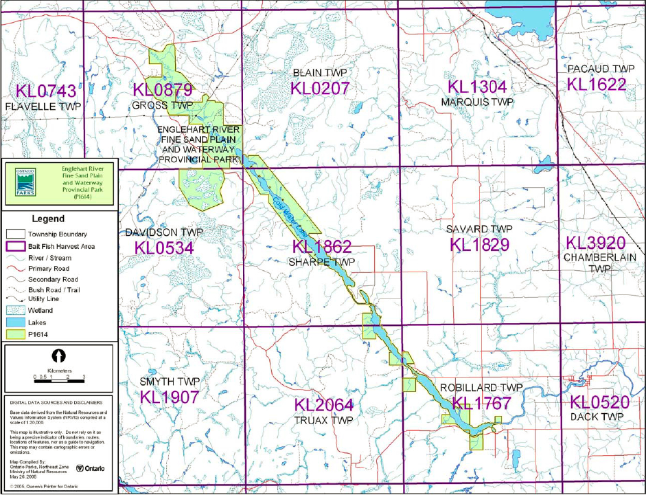
Gross (KL 0879), Davidson (KL 0534), Sharpe (KL 1862), Truax (KL 2064), and Robillard (KL 1767) townships are currently allocated for baitfish harvesting while Blain (KL 0207) Township is currently non-allocated (Figure 5).
Existing bait harvesting will be permitted to continue indefinitely in this park, however is subject to possible conditions identified during park management planning. New baitfish licenses will not be issued within park boundaries (OMNR 2004a).
Fish stocking
The stocking of native fish species may be considered through park management planning, with full public consultation. The stocking of non-native fish species will not be considered (OMNR 2004a).
6.0 Operations policies
6.1 Recreation management
Future planning, with full public consultation, will review direction on motorized and non-motorized recreation uses.
Figure 5: Commercial baitfish blocks
Enlarge Figure 5: Commercial baitfish blocks
6.1.1 Motorized recreation
Motorboats
Existing use may continue unless park features and values are threatened (OMNR 2004).
Snowmobiles
There is currently one authorized snowmobile trail that crosses the park in Gross Township.
Snowmobile use on established routes may continue. Proposals for new trails may only be considered through future planning with public consultation (OMNR 2000).
Off-trail snowmobile use is prohibited unless authorized by the superintendent under the authority the Provincial Parks Act and consistent with provincial park policy.
All-terrain vehicles
There are no authorized all-terrain vehicle (ATV) trails within the park. Proposals for new trails may only be considered through future planning with public consultation (OMNR 2000).
Off-road use of ATVs is prohibited unless authorized by the superintendent under the authority the Provincial Parks Act and consistent with provincial park policy.
Aircraft
Aircraft landings are permitted in the park, but are subject to regulation and valid aircraft landing permits issued by the park superintendent under the authority of the Provincial Parks Act (1990).
6.1.2 Non-motorized recreation
Camping
There are currently no developed camping facilities within the park; however there may be unmanaged campsites within the park boundary associated with the canoe route.
Existing use may continue in the interim, unless park values are threatened (OMNR 2004). Long-term management direction for camping facilities will be determined through park management planning, with public consultation (OMNR 2004).
Infrastructure will be permitted in order to protect park features and values in response to use, environmental deterioration and environmental protection requirements. Any proposed development in the park must fulfill the requirements of the Environmental Assessment Act.
Hiking
There is one unauthorized hiking trail (Teepee Trail) located in the northern area of the park.
Existing hiking trails may be permitted to continue unless such trails threaten park features and values, create user conflicts or raise safety/liability issues.
If there is an identified need, the development of new hiking trails may be considered. Trail infrastructure to protect park values and features will be permitted. Any proposed development within the park is subject to Environmental Assessment Act requirements.
Canoeing/kayaking
Existing uses may continue, unless park values are threatened (OMNR 2004). Infrastructure to protect park features and values may be permitted and developed in response to use, environmental deterioration and environmental protection requirements.
6.1.3 Emerging recreational uses
There are emerging recreational uses for which there is limited or no policy to deal with their management (e.g. adventure racing, geocaching). The park superintendent will use legislation, policy and guidelines that are in place in the interim to manage emerging uses.
6.2 Development
There is no existing park infrastructure located within the boundary this park.
Infrastructure to protect park features and values may be permitted and developed in response to use, environmental deterioration and environmental protection requirements. Any proposed development within the park is subject to MNR's requirements under the Environmental Assessment Act.
6.3 Commercial tourism
New commercial tourism facilities may be considered where consistent with park policy (OMNR 2004). Any development must meet the requirements of the Environmental Assessment Act.
7.0 Cultural resources
An assessment of the cultural resources specific to Englehart River Fine Sand Plain and Waterway Provincial Park has not been completed. The management of any cultural values within this park will be directed toward protection and heritage appreciation (OMNR 1992).
8.0 Heritage education
Literature and other supporting information may be developed to describe the park in the context of Ontario’s provincial park system. Boundary limits, significant heritage features and permitted uses of the waterway park may be included in park literature.
Prospective park visitors may be informed about the sensitivity and significance of park values through park literature.
9.0 Research
Scientific research by qualified individuals which contributes to the knowledge of natural and cultural history and to environmental and recreational management may be encouraged in the park. Ontario Parks will encourage institutions, such as universities, to undertake research projects.
All research programs will require the approval of Ontario Parks and will be subject to park policy and other applicable Legislation. Ontario Parks may approve the research of any natural or cultural features or values by qualified researchers. Any materials removed will remain the property of the Ontario Parks.
Approved research activities and facilities will be compatible with the park’s protection objective. Any site, which is affected, will be rehabilitated as closely as possible to its original state. Environmental Assessment Act requirements will apply.
10.0 References
Alkins, M., 2003. Natural Heritage Area Life Science Checksheet – P1614 Englehart River Fine Sand Plain and Waterway Provincial Park. Ontario Ministry of Natural Resources.
Brownell, V.R., and S. Blaney, 1995. A Biological Inventory and Evaluation of the Teepee Creek Study Area (Draft). Ontario Ministry of Natural Resources.
Canadian Environmental Protection Act, 1999.
Environmental Assessment Act, 1990.
Fisheries Act, 1985.
Fish and Wildlife Conservation Act, 1997.
Frey, E. and D. Duba, 2002. Earth Science Checksheet – P1614 Englehart River Fine Sand Plain and Waterway Provincial Park (Draft). Ontario Ministry of Natural Resources.
Harper, T., 2002. Englehart River Fine Sand Plain and Waterway Provincial Park (P1614) Recreation Inventory Report – Version 1.2. Ontario Ministry of Natural Resources.
Kor, P., 1994. Earth Science Inventory Checklist: Teepee Creek Gap & Kushog Lake Dune Complex. Ontario Ministry of for Provincial Parks and Conservation Reserves.
Migratory Birds Convention Act, 1994.
Mining Act, 1990.
Ontario Ministry of Natural Resources, 1974. A Topical Organization of Ontario History. Historic Sites Branch Division of Parks.
Ontario Ministry of Natural Resources, 1992. Ontario Provincial Parks Planning and Management Policies.
Ontario Ministry of Natural Resources, 1999. Ontario’s Living Legacy Land Use Strategy.
Ontario Ministry of Natural Resources, 2000. Ontario’s Living Legacy Land Use Strategy (Policy Clarification).
Ontario Ministry of Natural Resources, 2001b. Trapping in new OLL Parks.
Ontario Ministry of Natural Resources, 2003. Directions for Commercial Resource Use Activities in Provincial Parks and Conservation Reserves. 5 pp.
Ontario Ministry of Natural Resources, 2001. Public and Aboriginal Consultation Documentation Form – Ontario’s Living Legacy Protected Area Boundary Refinement Review – Englehart River Fine Sand Plain and Waterway Provincial Park.
Ontario Ministry of Natural Resources, 2004a. Crown Land Use Policy Atlas.
Ontario Ministry of Natural Resources, 2004b. Forest Fire Management Strategy for Ontario. Aviation and Fire Management Branch.
Ontario Ministry of Natural Resources. Ontario Ministry of Natural Resources, 2005a. Class Environmental Assessment for Provincial Parks and Conservation Reserves.
Ontario Ministry of Natural Resources, 2005b. Hunting Regulations Summary.
Ontario Ministry of Natural Resources, 2005c. List of Forest Management Units and Forest Management Plan Renewal Schedule 2005.
Ontario Ministry of Natural Resources, 2005d. Recreational Fishing Regulations Summary.
Pesticides Act, 1990.
Provincial Parks Act, 1990.
Appendix A: Background information
| Name | Provincial Park (P1614) |
|---|---|
| Classification | Waterway |
| Ecoregion/Ecodistrict | 3E-5 (Foleyet), 4E-5 (New Liskeard) |
| OMNR Administrative Region/District | Northeast – Kirkland Lake |
| Total Area (ha) | 4,041 |
| Regulation date & Number | May 2002 (O. Reg. 147/02) |
Representation
Earth science:
Englehart River Fine Sand Plain and Waterway Provincial Park is within the Abitibi Subprovince, in the Archean Superior Province. The sparse bedrock exposure of the park consists of hornblende granite and tonalite of the central part of the Round Lake Batholith and small areas of mafic metavolcanic rocks of the Catherine-Pacaud supracrustal assemblage. The flooded waterway of the Englehart River follows the Cross Lake Fault (Teepee Creek Gap Area of Natural and Scientific Interest), and the west boundary fault of the Lake Timiskaming Rift Valley, part of an extensive crustal fracture system within the Precambrian shield.
Thin sandy ground moraine till is present within the park to the southwest of the Englehart River. The surficial deposits of the park are mainly glaciolacustrine clays and silts east of the river and fine sand west of it.
Within the Ontario Parks system, the bedrock geology of the Englehart River Fine Sand Plain and Waterway Provincial Park has provincial significance in its representation of the Round Lake Batholith. It is the only park within the Batholith. The fault valley and escarpment of the
Englehart River is also a provincially significant component of the major regional crustal fracture system of the area (the Lake Timiskaming-Ottawa-Bonnechere Graben). The Kushog Lake dunes (north end of Kushog Lake/ Kushog Lake Dune Complex ANSI) are regionally significant post-glacial lake aeolian deposits.
Life science:
Englehart River Fine Sand Plain and Waterway Provincial Park is located in Northeastern Ontario, on the border of Ecoregions 3E and 4E with the most of this park in Ecodistrict 3E-5 (Foleyet) and a small portion in 4E-5 (New Liskeard).
The Teepee Creek Gap ANSI supports a mix of coniferous and intolerant hardwood species, as well as mixed pine uplands, jack pine, and coniferous communities. The Kushog Lake Dune Complex ANSI is characterized by poplar/aspen, jack pine, black spruce, and larch stands. Many of the wetlands found in the northern area of the park are provincially significant.
Long Lake supports a cool water fishery. Englehart River Fine Sand Plain and Waterway Provincial Park also includes waterfowl nesting areas, moose wintering/feeding/calving areas, and fish spawning areas.
Cultural resources:
An investigation and analysis of the cultural resources specific to Englehart River Fine Sand Plain and Waterway Provincial Park has not been completed at this time.
Recreation and tourism:
The majority of the recreation activity that occurs within the Englehart River Fine Sand Plain and Waterway Provincial Park is water based. Approximately thirty-four kilometres of the Englehart River is included in the park. The Englehart River is classified as a medium sized river*, and experiences peak flows during the months of April and May.
The Englehart River has an established canoe route. The route begins at the Englehart River Bridge on Highway 66, and finishes at Kap-Kig-Iwan Provincial Park or in the Town of Judge.
Other recreational activities include camping, boating, cottaging and hunting.
Several main base lodges are also located on private land along the shores of the Englehart River.
Angling has been an ongoing use. The fish species found in the river system include walleye, lake trout, lake herring, pike, ling, brown bullhead, smallmouth bass, yellow perch, and white sucker.
The Ontario Federation of Snowmobile Clubs (OFSC) Trans Ontario Provincial Series (TOPS) trail "A" crosses the park approximately 500 meters east of the utility corridor in Gross Township.
*See the recreation report for river classification criteria.
Inventories
| Survey Level | Earth Science | Life Science | Cultural | Recreational |
|---|---|---|---|---|
| Reconnaissance | Frey and Duba, 2002 |
Alkins, 2003 | Harper, 2002 |