Enhancing Ontario’s Forest Resources Inventory: spring 2014 update
The spring 2014 update on enhancements to Ontario’s Forest Resources Inventory. The update is used to support forest management planning, wood supply analysis, habitat analysis and provincial reporting.
What is the Forest Resources Inventory (FRI)?
The Ontario Forest Resources Inventory (FRI) is a strategic level survey of forested lands and wetlands in Ontario. This survey provides resource managers with a snap shot of the state of the forest, including information about tree species composition, range, age, and distribution, as well as, forest, ecological, and land use conditions. FRI data is collected across administrative boundaries, and is used to support forest management planning, wood supply and habitat analysis, and provincial, federal and international reporting.
Today’s users of the FRI require more current and detailed inventory data, therefore the scope and techniques used to create the FRI continue to evolve. In order to better meet these user needs the FRI program was enhanced in 2005 to include improvements such as: reducing the inventory cycle from 20 to 10 years, expanding the area to include the southern portion of the Far North Planning Area and national and large provincial parks, increasing the number of plot networks and calibration plots, and introducing a new post production inventory assessment component. The enhanced inventory also uses high resolution, digital airborne imagery and the inventory production process now involves more advanced technology to increase the accuracy and precision of the descriptive attributes.
The Forestry Futures Committee (FFC) and the FRI unit from the ministry are working to address new challenges associated with the implementation of the enhanced FRI by improving access to the FRI data and providing training for data users.
Spring 2014
Testing the provincial Digital Terrain Model (DTM)
Height is a key forest canopy characteristic (attribute) for assessing forest bio-metrics, which determines the amount of timber that can be harvested. In previous production cycles of the FRI, height was interpreted, and as a result heights could be extremely variable between interpreters and contractors. New technologies used in the current version of the FRI allow us to measure heights for each polygon resulting in more consistency between interpreters and interpretation contractors and more accurate height estimation and ultimately more accurate timber volume estimation.
Many FRI users are interested in deriving even more detailed, forest operations level information from the FRI data. Users could potentially develop some of this operational level information from the new FRI imagery, initially in the form of tree heights but may also be developing this operational information in the form of smaller, more homogeneous polygons.
There is interest in developing a canopy height model (CHM) to improve operation yield information and long-term wood product prediction. An automated method for determining canopy height could be developed as part of the FRI package for use in other analyses, for operational level planning by the forest industry and for other planning needs within the province. Currently the FRI determines tree canopy height by confirming the average height of the lead species in each polygon using a digital measurement. There is opportunity to create a CHM that will provide tree heights by comparing the elevation points supplied by the provincial digital imagery and associated digital surface models (DSM) and the elevation information supplied by the provincial Digital Terrain Model (DTM).
The provincial Digital Terrain Model (DTM), a tool that provides landscape elevation information across the province, was created using more traditional, manual, photogrammetric methods. In order to update the provincial DTM to meet FRI data user requirements, a new, cost-effective data capture method that can provide the appropriate level of detail will need to be adopted. This issue is currently being addressed by the minstry Digital Elevation Strategy committee.
There is a newer method for producing a more detailed DSM using an algorithm referred to as Semi Global Matching (SGM). SGM has the potential to save a significant amount of staff time and money from both public and private sector, and provide more statistical vigour to the inventory.
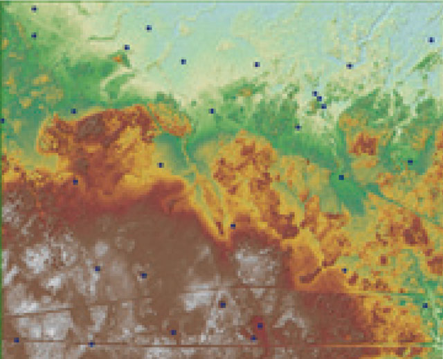
Figure 1. Proposed elevation points that could be captured using a new canopy height model (CHM).
Enlarge Figure 1 elevation map
Changes in workflow could be integrated into the FRI process using SGM in order to create point elevation data from FRI stereo imagery to increase the reliability of the provincial DTM. In this respect, the FRI Program and the Water Resources Information Program (WRIP) are exploring a Rubber Sheet method that involves extracting ground elevation values from the FRI DSM (SGM) and using these more accurate values to improve the provincial DTM.
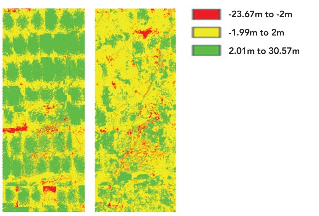
Figure 2: The colours in these two figures show the range of errors in elevation points predicted by the provincial DTM when subtracted from lidar elevation points. The figure on the left shows a large amount of area where elevation differences range from 2 to 30 metres. Although there may be some tangible explanations for these differences, such as elevation points being assigned to water bodies and dense forest conditions that are difficult to see the ground through, the error differences could be a point of concern for some users. The figure on the right depicts the final DTM elevation information (again subtracted from lidar elevation points) that was corrected using the Rubber Sheet method.
One possible approach for extracting ground elevation values from FRI and increasing the accuracy of the DTM includes:
- Manually placing points on open ground, water, roads, etc.
- Using FRI polygons to identify areas of open terrain
- Using the following classes: Open Muskeg (OMS), Unclassified Land (UCL), Productive Forested (FOR) (zero metres in height and an age less than 4 years)
- Placing random points within polygons
- Developing a classification method for SGM files
FRI contract update
Five forest management units (MU) were contracted for FRI production this year; Mazinaw- Lanark (9,734 km2), Ottawa Valley (8,041 km2), Nagagami (4,455 km2), Timiskaming (15,311 km2), Lake Nipigon/Armstrong (15,942 km2).
To date, the total area for which interpretation is complete is 97,560 km2, and the total area for which interpretation is currently in progress is 281,699 km2.
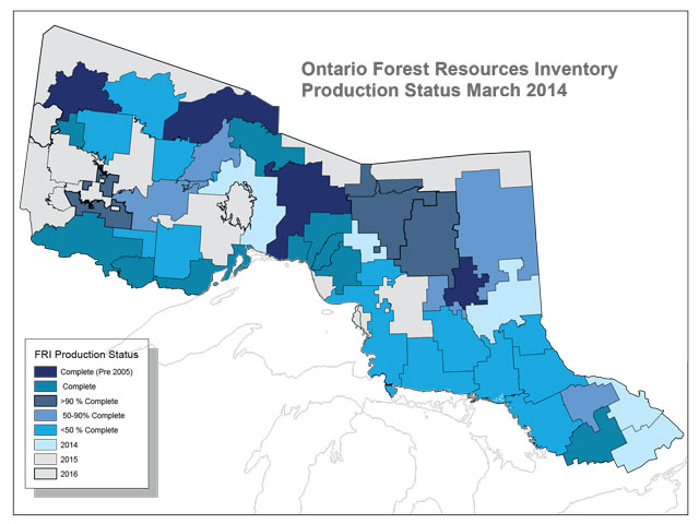
Figure 3: This map depicts the current status of FRI production.
FRI calibration plots
FRI calibration plots are generally established at a frequency of one plot for every five to eight square kilometres within a given inventory project area. Data collected from the measurement of FRI calibration plots provide photo interpreters with valuable information concerning forest conditions associated with their respective inventory projects. Photo interpreters use this knowledge of local forest conditions as an aid in interpreting adjacent and surrounding lands which lack ancillary data. Over 60,170 calibration plots have been established and measured since beginning the new inventory cycle in 2007.
An additional 17,453 calibration plots were established and measured in 2013 in Algoma, English River, Sapawe, Spanish, Sudbury, Temagami, and Trout Lake management units. Within this year’s units of Mazinaw-Lanark, Ottawa Valley, Nagagami, Timiskaming), and Lake Nipigon/Armstrong, approximately 10,700 FRI calibration plots will be located and measured.
Post inventory assessment plots
Traditional Forest Resources Inventories in Ontario generally lacked information describing the overall effectiveness of the inventory product, however, the enhanced FRI Program addressed this missing element and now includes post inventory assessment activities as an integral part of the inventory process. This enhancement will provide FRI end-users with a statistical evaluation of key forest inventory metrics, and promote continuous improvement in the FRI information product.
The inventory assessment procedure will assess the accuracy of the volumes generated with the new eFRI procedures, aggregated to the Provincial Forest Unit by comparing those volumes to volumes determined through wood volumes drawn from a field sampling program.
An Inventory Assessment Plot Specifications Manual has been developed, the sampling protocols have been established with ministry FRI staff and they began testing the post inventory assessment procedures in the fall of 2012 on the Marathon Block.
The plot selection process was finalized for the Marathon Block pilot testing and 213 polygons in six Provincial Forest Types were randomly selected using a statistical technique (probability proportionate to size with replacement) from 33 Ontario base maps. During the study in Marathon Block, FRI staff reviewed aspects such as plot design, plot establishment procedures, work flow, tally sheet functionality, attribute collection, time trials, and plot accessibility issues. Post inventory assessment plot production will begin in 2014.
Any modifications required from the pilot program for the field procedures or the analysis perspectives will be reviewed and altered where necessary.
FRI training update
Boreal and Great Lakes/St Lawrence training:
Boreal and Great Lakes/St. Lawrence photo interpretation certification opportunities and training were held in Sault Ste. Marie, Ignace, and Thunder Bay in 2013. In total, 105 people attended the training. There were 76 successful participants in the training who obtained either their Boreal or Great Lakes/St. Lawrence Certification, and in some cases participants they obtained both.
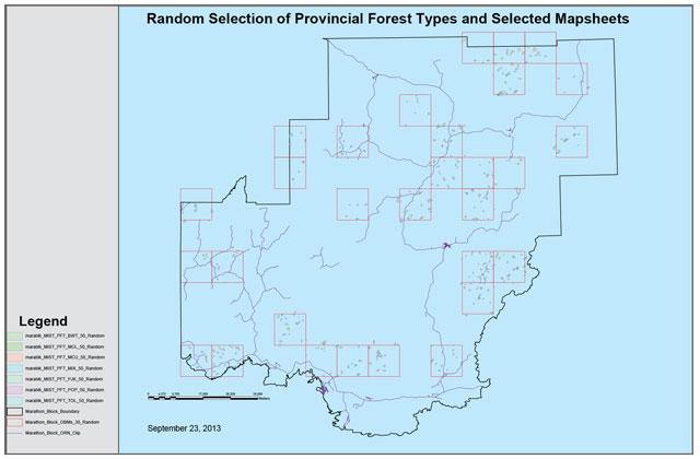
Figure 4: An example of the distribution of Ontario Base Map and polygon selections over the Marathon Block Unit (comprised of Pic River/Ojibway, Black River and Big Pic Management Units).
Post inventory assessment development and training
The FRI knowledge transfer initiative includes a training component to "introduce" the new FRI to management unit stakeholders. The training initiative is organized and directed by the FFC in partnership of the FRI program. Training is focused on specific target audiences impacted by integrating a new data set, including planning teams, industry, and regional and district staff.
These training opportunities are intended to enhance the understanding of the inventory and provide insight into how the FRI is created, particularly procedural changes in the creation of the inventory information. For example, major changes occurring in the new iteration of the FRI include the increase in the number of polygons, identification of two-tier stands, stocking determination, Ecological Land Classification, and integration of silviculture and disturbance information. Training sessions are useful in identifying the potential implications these changes may have, and to assist in the mitigation of any potential issues. The training is also intended to assist with the integration of other business units and their data into the new inventory.
To date, two training sessions were held in Thunder Bay and Orillia for forest managers, and one (more technical) training session was held in Thunder Bay for imagery users. All three sessions were hosted by Lakehead University.
Post inventory training often provides opportunities to focus the FRI program inventory development process and identify opportunities to provide meaningful assessments of specific FRI attributes and whether the FRI is meeting its objectives.
Next planning cycle
In order to continue to enhance the strengths of the FRI and address or mitigate the challenges associated with it, it is important that the next planning cycle involves even more integration between the FRI, Forestry Futures Committee, the Provincial Forest Inventory Advisory Committee, the Joint Integration Technical Committee (Forest Information Manual rewrite, Forest Information Portal), the Forest Analysis and Modelling Unit (Forest Management Planning Manual rewrite), Silviculture Effectiveness Monitoring, Forest Policy, Ecological Land Classification, and Growth and Yield.
This integration is also important for post inventory assessment efforts such as: investigating the opportunities in using the SGM dataset, including comparative statistics for heights, crown closure determinations, and wildlife indices; determining how to incorporate the direction for integrated plot networks; and developing analysis techniques to make use of the post inventory assessment plots and the permanent forest inventory plot network.
These efforts will ultimately help to improve understanding of the FRI in the context of other business areas and their unique needs and challenges.
More information
For more information on the Forest Resources Inventory, please contact the Forest Resources Inventory Coordinator,
Cette publication hautement spécialisée Enhancing Ontario’s Forest Resources Inventory -- Spring 2014 Update, n'est disponible qu'en Anglais en vertu du Règlement 411/97 qui en exempte l'application de la Loi sur les services en français. Pour obtenir de l'aide en français, veuillez communiquer avec au ministère des Richesses naturelles.
erika.luoma@ontario.ca
ISSN 1918-6185 (PDF)