Foy Provincial Park Management Plan
This document provides direction on the management of Foy Provincial Park.
Foy Provincial Park Management Plan
MNR 3513
ISBN 0–7729–1204–1
1986 Government of Ontario
Limited copies of this publication are obtainable at the Ministry of Natural Resources, Huntsville Regional Office, Box 9000, Huntsville, Ontario, POA 1KO, (705-789-9611); the district office at Pembroke, Riverside Drive, Box 220, Pembroke, Ontario, K8A 6X4, (613-732-3661); Bonnechere Provincial Park, do R.R. *5, Killaloe, Ontario KO3 2AD, (613-757-2103)
Approval statement
Foy Provincial Park was established in 1985 to provide outstanding outdoor recreation day use opportunities in Renfrew County’s Big Timber Country Tourist area. Although no development has occurred in the Park it will ultimately provide outstanding day use opportunities due to the Park’s high quality natural beaches, natural setting and significant earth and life science features found within the Park’s boundaries.
"We are pleased to approve the Foy Provincial Park Management Plan, as official policy for the management and development of this park. The plan reflects this Ministry’s intent to protect natural and cultural features of Foy Park and maintain and develop high quality opportunities for outdoor recreation and heritage appreciation for both residents of Ontario and visitors to the Province."
1.0 Introduction
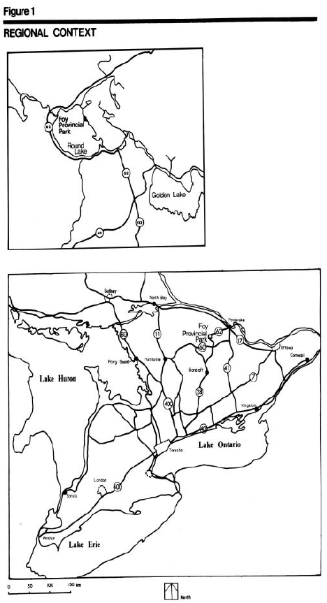
Foy Provincial Park is situated in Richards Township, County of Renfrew, in east central Ontario. The Park is located on Round Lake on the northeast shore (Figure 1). Highway 62 is situated 3000 metres north of the Park, providing good access from the large urban centres of Pembroke, Barry’s Bay, Bancroft and Eganville. Foy Park is approximately 160 kilometres northwest of Ottawa, 48 kilometres west of Pembroke and 400 kilometres northeast of Toronto by road.
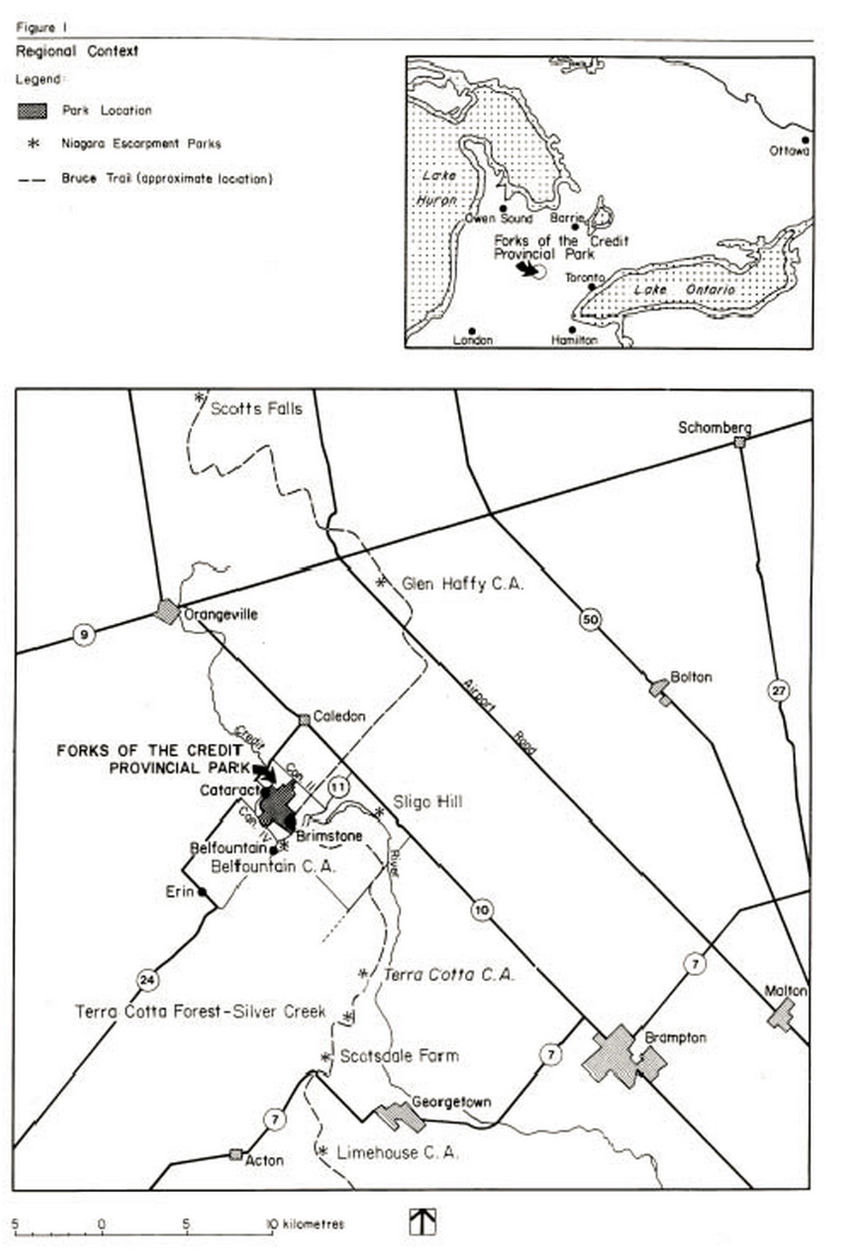
The Foy property encompassing 148 hectares, was purchased in 1968 as an addition to Bonnechere Provincial Park and put into regulation in 1985 as Foy Provincial Park, a Recreation classed Park. However, no development has occurred in Foy with the exception of a junior ranger camp, which has been operative for the past eight years.
The relationship between Foy and Bonnechere Provincial Parks is substantial, however, only Foy Park will be emphasized in this management plan. Inquiries concerning Bonnechere Park may be answered in the Bonnechere Provincial Park Management Plan.
Foy Park is located within the Grenville Province of the Precantrian Shield. The Park straddles an extensive area of broken till mantled bedrock uplands and a lacustrine sand plain which is indicative of Bonnechere River Valley’s glacial past. A quartz monzonite intrusive forms most of the Park’s bedrock.
The topography of Foy Park can be attributed to the last ice-age and the large glacial lake, which covered the present-day Round and Golden Lakes. The Park is a mixture of lowlands accompanying deep sand and sandy till soils along the shore of Round Lake, west of the township road traversing the property. Hilly topography with generally thin soils cover the area east of the road.
Foy Park is located within the Middle Ottawa Section of the Great Lakes–St. Lawrence Forest Region. Eight forest communities have been identified. However, most of the area is covered by the white pine-red oak community.
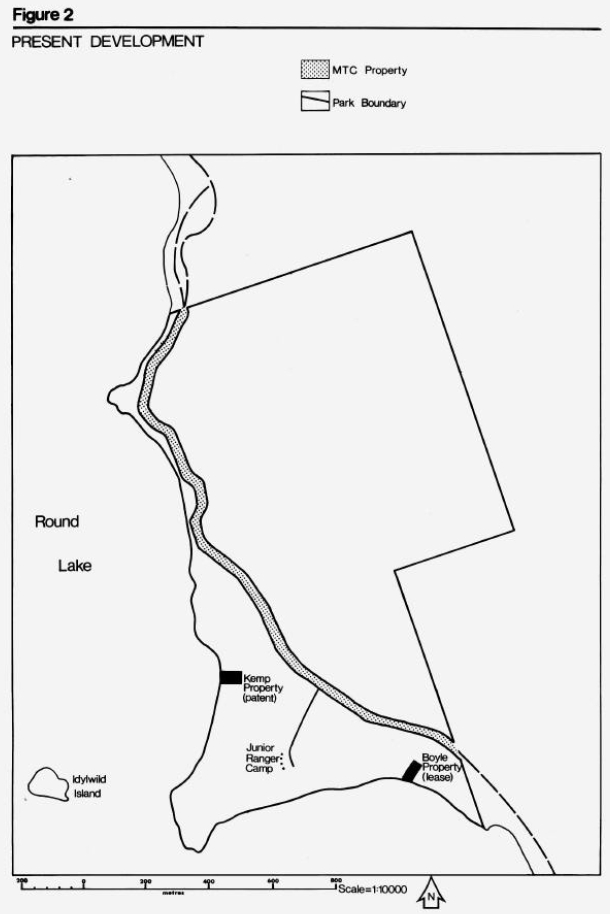
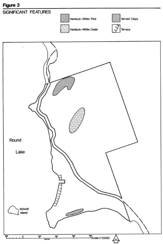
Locally significant features are the representative stands of hemlock-white pine and hemlock-white cedar (Figure 3).
Two regionally significant earth science features are found in Foy Park: a wave cut terrace and an exposure of varied clays, both relict lake features. (Figure 3).
2.0 Summary of significant issues
Because of no facilities, Foy Park is at present posted for no camping and all access roads are gated. However, local residents and cottagers recognize the Park’s recreation attributes and continually use the natural beaches. They gain access either by boat or walk–in after parking their car along the township road. Such uncontrolled use of undeveloped Crown lard leads to maintenance problems and could cause degradation of any significant physical or biological sensitive area.
Management and development guidelines need to be formulated to not only identify the facilities that are needed bit also how to protect any significant sensitive areas.
3.0 Classification
Foy Provincial Park will be classified as a Recreation Park. This is due to the Park’s high quality natural beaches, orientation of its two beaches to the south and west, and its good access f ran local urban areas.
Recreation Parks are areas, which support a wide variety of outdoor recreation opportunities for large numbers of people in attractive surroundings.
4.0 Park goal
The Park goal will be to provide and maintain quality summer-oriented day use facilities within the context of Recreation classed Parks.
Figure 1: Regional context
Enlarge Figure 1: Regional context
Figure 2: Present development

Enlarge Figure 2: Present development
5.0 Park objectives
Foy Provincial Park contributes the achievement of the following four objectives of the park system for Recreation Parks.
5.1 Recreation objective
To provide day use opportunities in areas of outstanding recreational potential.
Quality seasonal day use opportunities (26,000 swimming and 9,000 picnic opportunities) some of which are now being offered at Bonnechere Provincial Park will be transferred to Foy Provincial Park. Individuals, families and groups will have every opportunity for social interaction with fellow recreationists.
5.2 Protection objective
The protection of a system of provincially significant natural environments incorporating natural, cultural and recreational features.
By ways of development and management strategies, significant earth and life science features such as the wave cut terraces and exposure of varved clays will be protected.
5.3 Heritage appreciation objective
To provide opportunities for exploration and appreciation for natural and cultural environments through interpretation and education based upon the character and significance of this Recreation Park.
By way of self-use facilities and information, opportunities to explore and appreciate the natural and cultural history of the Park and surrounding area will be provided.
5.4 Tourism objective
To facilitate travel by residents of and visitors to Ontario who are discovering and experiencing the distinctive regions of the Province.
Foy Provincial Park will provide day use opportunities for residents from local urban centres, private cottages and local commercial establishments, as well as destination day-use opportunities for those attracted from considerable distances.
All intensive day use activities will be restricted to this zone.
6.0 Park boundary
There are two non-conforming lard uses within Foy Provincial Park’s boundaries, a .08 hectare privately owned parcel of land on the west beach and a leased property on the south beach area. Both properties are located within the Park’s proposed development zones.
Serious consideration will be given to purchase the privately owned lot if it is offered for sale and money is available. The lease will not be renewed after it expires in 1992. The lessee will be given appropriate time to remove any improvements from the property.
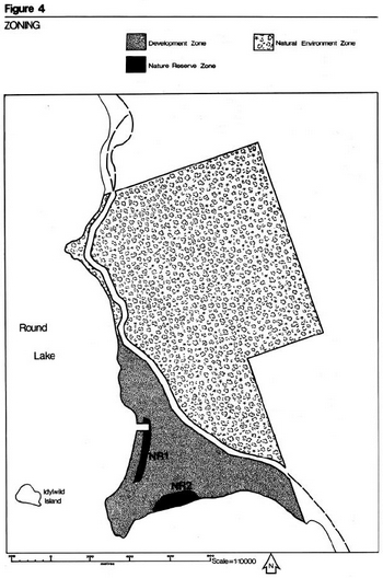
7.0 Zoning
Lands and waters within a Provincial Park are zoned so that they may be assigned the mast appropriate use and management relative to the Park.
Facilities and services for a wide range of day use and camping activities are provided in Development Zones.
Natural Environment Zones include attractive landscapes in which a minimum of development is required to support low intensity day use recreational activities (i.e. walking trails).
Significant earth and life science features which require management distinct from that in adjacent zones are included in Nature Reserve Zones.
7.1 Development zone (12.4 ha)
The Development Zone is located west of the Red Rock Road (Figure 4). This zone will provide access to the recreation facilities and the junior ranger camp.
7.2 Natural environment zone (95.8 ha)
The Natural Environment Zone covers most of the Park area (Figure 4).
Development will be limited to trails, necessary signs, minimal interpretive facilities, and similar simple facilities, which will support low intensity day use recreational activities.
7.3 Nature reserve zones (1.74 ha)
Two Nature Reserve Zones are required to protect two regionally significant earth science features (Figure 3).
Nature Reserve 1 (1.28 hectares) will protect a wave cut terrace that is the evidence of a glacial lake shoreline.
Nature Reserve 2 (.46 hectare) protects an exposure of varved clays in a low bank that is also evidence of this former glacial lake’s existence.
Both zones will require management strategies to protect the areas from erosion through uncontrolled pedestrian or vehicle traffic.
Vehicle traffic will be prohibited from crossing NR1. Pedestrian traffic across NR1 should be encouraged to use either the existing old road or new designated paths.
Both pedestrian and vehicle traffic will be kept away from NR2 to prevent slumping of the bank destroying the feature will to be protected.
8.0 Resource management
Natural resources of Foy Park will be managed within the administrative policies for resource management in Recreation Parks.
8.1 Vegetation
Certain management techniques must be applied to maintain a particular kind and quality of vegetation in a given area within the Park. Zones with vegetation progressing through natural succession will have different management techniques from zones where vegetation is maintained at its present stage of natural succession.
Some management practices will produce small quantities of wood as by-products of selective and dead tree removal. The wood, depending on type and quality, can be used for firewood, sawlogs, posts, or other required items for the Park. By this means, small savings in both maintenance and capital costs may be realized. However, it mist be remembered that the main purpose of these management techniques is to maintain or create a particular quality of vegetation and not to generate revenue.
A vegetation management plan will be prepared to meet the diverse management requirements specific to the Park and to provide direction to park staff. The plan will be prepared by the Park Superintendent in conjunction with other Ministry staff and outside experts as required and in consideration of the following prescriptions for each zone.
8.1.1 Development zone
Vegetation cover in the beach day use areas will be maintained in a park-like setting, with a varying aged overstory and replacement trees in areas of sparse understory. Open spaces will also be developed and maintained.
8.1.2 Nature reserve zone
Areas designated under this zoning will be allowed to progress through natural succession.
8.1.3 Natural environment zone
Areas designated under this zoning will have a silvicultural program to promote and maintain growth of healthy aesthetically pleasing forest cover.
8.2 Wildlife
There are no wildlife management programs planned for the Foy Park because of its size.
Hunting is prohibited in the Park.
Portions of existing traplines within the Park’s boundaries will be excluded from the licence. However, the trapper affected by this policy may be requested by the Park Superintendent to trap ‘nuisance’ animals.
Figure 3: Significant features
Enlarge Figure 3: Significant features
Figure 4: Zoning
8.3 Fisheries
Round Lake is a cold water lake. Although once a prime source for lake trout fishing opportunities, the stocking of lake trout has been discontinued due to incomplete natural stocking, over-harvest, undesirable species composition and degraded habitat.
Other fish species present in Round Lake are: Yellow pickerel, whitefish, northern pike, small mouth bass and large mouth bass.
There is no commercial fishing on Round Lake.
8.4 Resource extraction
No commercial extraction of resources will be permitted within the park area.
There are no mining activities in the immediate vicinity of Foy Park.
8.5 Water
Water quality of Round Lake will be monitored by the present water quality sampling program. Any deterioration in water quality will be investigated by this Ministry in cooperation with the Ministry of the Environment.
The water level on Round Lake is controlled by the Hydro-electric Power Commission of the Town of Renfrew. The water level is not to exceed the 555.6 foot contour. This water level control has no major effects on water –based recreation opportunities during the park operating season.
The 1978 survey of Round Lake by the Ministry of the environment revealed excellent water quality conditions for recreation use. Seasonal average chlorophyll and Secchi disc visibility measurements indicated a low level of biological productivity (i.e. algae) and a high degree of water clarity.
8.6 Fire
Normal methods of fire detection and suppression will be carried out to protect the Park’s resources.
8.7 Insects and disease
Measures for insects and disease control will be permitted, when necessary, to protect visitor health and Park values. Nature Reserve Zones will be included because of difficulty in separating them from overall treatment.
9.0 Visitor services
Foy Provincial Park will offer a basic level of visitor services programming which will include the three components of visitor services: Information, Interpretation and Outdoor Recreation.
The Park will be operated in accordance with the current Operating Plan.
9.1 Information
This program will provide a high quality communications service to visitors through a carefully organized system of signage, publication, displays and limited personal service.
Although no visitor services staff will be available, the park visitor will have access to informed park staff. The staff should be knowledgeable about the Park, its facilities, rules and regulations as well as local area services and attractions.
9.2 Interpretation
Interpretive programs will provide visitors opportunities to learn arid experience the character arid significance of the Park arid surrounding area. These programs will be based on natural arid cultural features of the park landscape.
Self-use facilities such as trails with trail guides, and exhibits or displays at the Park’s control points will be provided.
9.3 Recreation
Appropriate volunteer recreation skill teaching programs such as canoeing, camping, etc. that are being offered at Bonnechere Provincial Park, may be also scheduled to be held in Foy.
9.4 Marketing
A marketing plan to attract visitors to Foy Provincial Park throughout its operating season will be prepared with the following objectives: to attract day users staying at local commercial establishments or using local services; to attract day users from local urban centres arid private cottages; to encourage park users to use arid take advantage of local tourist services arid generally stimulate interaction between the Park and the private tourist and commercial sector in the vicinity.
10.0 Development
Foy Park will be developed to provide quality day use facilities, helping to eliminate Bonnechere Provincial Park’s crowded day use conditions arid traffic problems. The junior ranger camp located in the Park will remain and function in its intended capacity.
Development will proceed in accordance with Figure 5 arid the following guidelines. In all instances, detailed site plans will be completed arid approved in advance of development of new facilities. Development projects will be phased according to the Implementation Strategy (Section 10.0), as needed arid funding permits. The requirements of the Environmental Assessment Act will be adhered to.
10.1 Beach access development
Development of the west and south beach areas will reflect the management guidelines for the Nature Reserve.
Pedestrian travel only will be allowed across Nature Reserve Zone 1. The use of existing roads is recommended. If other access is needed, an appropriate structure, such as a boardwalk, will reduce the impact of use on the terrace slopes. Signs will be posted to explain the fragile nature of this feature.
10.2 Road system and parking lots
A simple road system will be constructed to provide access to both beach areas parking lots, boat launch arid to the junior ranger camp.
Parking lots will be needed behind the two beach areas. The capacity of each parking lot should be approximately one-quarter of the instantaneous beach capacity (assuming four people per vehicle).
A small parking lot for vehicles arid trailers will be needed at the boat launching area.
10.3 Sanitary services
Both day use beach areas will be serviced by an appropriate number of vault toilets arid change houses to satisfy peak use demand requirements. The present change house in Bonnechere Park will be relocated to a site near the parking areas.
10.4 Picnic tables
Picnic tables will be provided along the backshore of the beaches as well as in the vicinity of parking lots, the number of tables will correspond to the number of parking spaces available.
10.5 Gate entrance
A simple gate entrance managed by Bonnechere staff or an honour pay system will be situated at the Park’s entry. A small courtesy parking area with information kiosks will be located adjacent to the gate entrance.
10.6 Administration
Staff accommodations, maintenance facilities arid park office will be shared with Bonnechere Provincial Park.
10.7 Boat launch
A boat launch area will be developed on the south shore. The location should not interfere with the protection of Nature Reserve Zone 2.
10.8 Group recreational area
Open space areas will be provided for day users. The site plan for replanting the old field will leave areas available for open space recreation.
Figure 5: Future development

Enlarge Figure 5: Future development
10.9 Trail system
Several scenic vista points are located in the rugged area east of Red Rock Road, overlooking the Round Lake area. A 2 to 3 kilometre trail through the hardwood forest arid along the granite ridges will link these vista points together.
11.0 Implementation strategy
This management plan will be reviewed at least every ten years following its approval or sooner if the need arises. Data collection arid environmental monitoring will be conducted regularly.
Below is a list of projects that have been previously described in this plan. This list appears in chronological order according to the individual projects priority. The number of projects to be completed or partially completed will be based upon the availability arid allocation of each year’s capital funding.
Projects described in plan:
| Priority Rating | Project Description |
|---|---|
| 1 | Beach Access Development |
| 2 | Road System and Parking Lot Development |
| 3 | Sanitary Services |
| 4 | Picnic Tables |
| 5 | Gate Entrance |
| 6 | Establishment of Administration |
| 7 | Marketing Management Plan |
| 8 | Boat Launch and Parking area |
| 9 | Vegetation Management Plan |
| 10 | Recreational Area for Group Activities |
| 11 | New Trail System |
12.0 Public consultation
A preliminary management plan concerning Bonnechere Provincial Park arid Foy Property (now Foy Provincial Park) was written arid made available to park visitors, adjacent landowners arid local township offices to be reviewed and commented on. Very few comments were received. Most are in agreement of what was being proposed.
13.0 References
Development Committee of County Council. Approach to Development: A Development Concept for the County of Renfrew, County of Renfrew, 1973.
Edwards, R. The Timber Trade of the Bonnechere River Valley, Volume 1, Ministry of Natural Resources, Huntsville, 1975.
Gillepsie, J.E. Soil Survey of Renfrew County- Report No. 37, Department of Agriculture, Ottawa, 1964.
McKenna, E. A Systematic Approach to the History of the Forest Industry in Algonquin Park, 1835-1913. Ministry of Culture and Recreation, Queen’s Park, 1976.
Noble, Terry. Biophysiographic Analysis, Site Region 5E, Algonquin Region. Queen’s Park, 1976.
Ontario Ministry of Natural Resources. Algonquin Provincial Park: First Five-Year Review, 1979, Queen’s Park, 1979.
Ontario Ministry of Natural Resources. Background Information, Pembroke District, Huntsville, 1975.
Ontario Ministry of Natural Resources. Ontario Provincial Park Planning and Management Policies, Queen’s Park, 1978.
Ontario Ministry of Natural Resources. Pembroke District Land Use Guidelines, Regional Lands Office, 1983.
Ontario Ministry of Natural Resources. Provincial Park Camper Survey Summary Statistical Report, Parks Planning Section, Toronto, 1983.
Ontario Ministry of Natural Resources. Provincial Park Day User Survey Summary Statistical Report, Parks Planning Section, Toronto, 1983.
Ontario Ministry of Natural Resources. Ontario Provincial Parks Landscape Design Principles and Guidelines, Parks Planning Section, Toronto, 1977
Province of Ontario users Manual. Ontario Recreation Supply Inventory, 1975.
Rowe, J.S. Forest Regions of Canada, Canadian Forestry Service, Ottawa, 1972.
Showkewych-Hanna, R. Preliminary Botanical Inventory of the Bonnechere Study Area, Environmental Planning Series VI, 18, Ministry of Natural Resources, Huntsville, 1975.
Spek, C.M. Brief Geomorphology and Geology on the Bonnechere Study Area Including Bonnechere Provincial Park, Environmental Planning Series VI, 17, Ministry of Natural Resources, Hunstville, 1975.
Spek, C.M. A Brief Update of the Surficial Geology of the Foy Provincial Park Reserve on Round Lake, Renfrew County, Ministry of Natural Resources, Huntsville, 1978.