Frontenac Provincial Park Management Plan
This document provides direction on the management of Frontenac Provincial Park.
Approval Statement
August 4, 2016
I am pleased to approve the Frontenac Provincial Park Management Plan as the official policy for the management of this protected area. The plan reflects the intent of the Ministry of Natural Resources and Forestry, Ontario Parks to protect the natural and cultural features of Frontenac Provincial Park and to maintain the park’s ecological integrity.
The policies and direction outlined in this plan enable the active management required for the successful protection and restoration of the diverse ecological values of the park, while also acknowledging its potential to offer exceptional natural heritage appreciation and low impact recreation opportunities.
This document outlines the policies and implementation priorities for the park and summarizes the Indigenous community, stakeholder and public involvement that occurred as part of the planning process. The plan for Frontenac Provincial Park will be used to guide the management of the park over the next 20 years. During that time, the management plan may be examined to address changing issues or conditions, and may be adjusted as the need arises.
I wish to extend my sincere thanks to all those who participated in the planning process.
Bruce Bateman
Director, Ontario Parks
1.0 Introduction
Frontenac Provincial Park was regulated in 1974, following completion of a Master Plan Report. This 5,214 ha park embraces a "Threshold Wilderness" concept for its management, providing visitors with the opportunity to experience backcountry travel in a convenient location and semi-wilderness environment (Section 6.2).
Frontenac Provincial Park is located in South Frontenac Township in Frontenac County, approximately 35 km north of the City of Kingston, in eastern Ontario (Figure 1). The park is centrally located between three large population centres of Ottawa, Toronto and Montréal and is within a three hour drive for almost nine million people. A diversity of natural and historic tourist attractions are present in the area, including Charleston Lake Provincial Park and the Rideau Canal waterway to the east, and St. Lawrence Islands National Park to the south.
The park is within Ecodistrict 6E-10, which encompasses a narrow extension of the Precambrian Shield known as the Frontenac Axis. Typical of the ecodistrict, the park’s landscape is characterized by mixed and deciduous forest on shallow soil interspersed with frequent rock barrens and waterbodies. The habitat and species diversity of Frontenac Provincial Park is considered exceptional within the ecodistrict. The park includes some 789 plant species and some 331 fish, wildlife, birds, reptiles and butterfly species, many of which are uncommon in this part of Ontario. Frontenac Provincial Park is also culturally rich. There is potential for pre-contact and historic Indigenous archaeological resources within the park. Influences on the landscape from European settlement date back over 150 years, and remnants of homesteads, barns, roads, mines, and logging activities are scattered throughout the park.
Frontenac Provincial Park receives between 25,000 and 30,000 visitors annually (Ontario Parks 2014). Many visitors are attracted to the park for its "Threshold Wilderness" experience. Development at the park is mainly limited to the area around the park office. This area is connected by a 4 km gravel road, two parking lots and a boat launch on Big Salmon Lake that provide access to the park interior, including the park’s network of over 100 km of interior routes and 48 backcountry campsites.
Detailed information on the park’s setting, natural and cultural heritage features and use is provided in Frontenac Provincial Park, Background Information (Ontario Parks 2005), available electronically and in hard copy from Ontario Parks.
Frontenac Provincial Park lies within the boundary of the Ministry of Natural Resources and Forestry (MNRF) Peterborough District and is managed by the park superintendent, reporting to the zone manager at the Ontario Parks Southeast Zone office.
2.0 Planning context
The Provincial Parks and Conservation Reserves Act, 2006 (PPCRA) requires that management direction is prepared for each protected area in Ontario. This management plan fulfils this requirement, and provides direction for managing Frontenac Provincial Park, including the park’s purpose and vision, objectives, zoning, policies and implementation priorities. This management plan is written with a 20 year time horizon in mind.
The PPCRA has two guiding principles for park planning and management:
- Maintaining ecological integrity shall be the first priority and restoring ecological integrity shall be considered.
- Opportunities for consultation shall be provided.
Other legislation (e.g., Endangered Species Act, 2007 (ESA), Ontario Heritage Act, 2005), policies, initiatives (e.g., climate change, invasive species) and best practices (e.g., adaptive management, landscape level planning) also provide additional direction for protecting Ontario’s biodiversity and contribute to guiding protected area planning and management.
This park management plan has been prepared consistent with all relevant legislation and provincial policies. The implementation of projects in this provincial park will comply with the requirements of A Class Environmental Assessment for Provincial Parks and Conservation Reserves (Class EA-PPCR). This may include further opportunities for consultation, as required.
2.1 Ecological integrity
Ecological integrity is a concept that addresses three ecosystem attributes – composition, structure and function. This concept is based on the idea that the composition and structure of the protected area should be characteristic for the natural region and that ecosystem functions should proceed normally. Simply stated, ecosystems have integrity when their lands, waters, native species and natural processes are intact.
All planning and management activities for Frontenac Provincial Park will consider ecological integrity first and foremost in their implementation.
3.0 Indigenous communities
Frontenac Provincial Park is located within the area of the Algonquin land claim being negotiated by the Government of Canada, the Government of Ontario and the Algonquins of Ontario at the time of preparation of this plan. The park is located within the consultation area as defined by the Consultation Process Interim Measures Agreement (2009). The Algonquins of Ontario have expressed an interest in Frontenac Provincial Park through their communities.
The Mohawks of the Bay of Quinte are located at Tyendinaga to the southwest of the park. The park is located within an area of interest to the Mohawks of the Bay of Quinte.
A Stage 1 archaeological assessment for the park was completed in 2014 (Central Archaeology 2014). The report concluded potential for pre-contact and historic Indigenous archaeological resources within the park, based on landscape features including water features, topography, geology, and possible temporary use post-contact (Section 7.1.3).
Examples of Aboriginal rights, values or areas of interest throughout Frontenac Provincial Park and environs may include: burial sites; historic canoe routes; hunting, gathering and fishing; Moulton Gorge; Labelle Gorge; birch bark harvesting site; cedar harvesting site.
Opportunities for Indigenous community involvement in the planning process have been provided and the content of this document has been influenced as a result.
Additional related content can be found in:
- Appendix 1 Summary and results of Indigenous community consultation
- Section 7.1.3, Cultural heritage resources
- Section 9.4.10, Cultural heritage resources management
- Section 9.6.2, Education
- Section 9.6.3, Partnerships
The PPCRA provides for the disposition of park lands as part of a settlement of a claim in respect of Aboriginal rights (c. 12, s. 9 (5)).
Nothing in this plan shall be construed so as to abrogate or derogate from the protection provided for the existing Aboriginal or treaty rights of the Indigenous peoples of Canada as recognized and affirmed in section 35 of the Constitution Act, 1982.
The Algonquins of Ontario have informed Ontario Parks of the intention to assert and exercise Aboriginal rights to hunting, gathering and fishing within Frontenac Provincial Park.
4.0 Park classification
Through park classification, Ontario’s provincial parks are organized into broad categories, each of which has particular purposes and characteristics. Frontenac Provincial Park is classified as a natural environment park.
Natural environment parks protect outstanding recreational landscapes, representative ecosystems and provincially significant elements of Ontario’s natural and cultural heritage. These parks provide high quality recreational and educational experiences.
Frontenac Provincial Park contains a wide range of habitats and high species diversity in a relatively small area. The park supports backcountry travel through an extensive system of lakes, portages and trails. This network links many ecological sites and historic cultural heritage resources of interest, including gorges, a bog, homesteads, and mines. Visitors are drawn to the park’s "Threshold Wilderness" experience.
Figure 1: Regional Setting
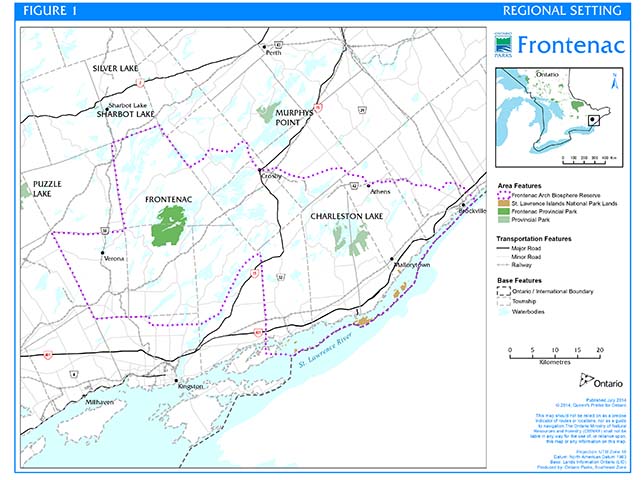
Enlarge Figure 1: Regional Setting Map (PDF, 2.6MB).
5.0 Boundary
Frontenac Provincial Park comprised 5,140 ha when it was established in 1974. A few minor boundary amendments, regulated in 1998, increased the park area to its current size of 5,214 ha. The park is now designated as a natural environment class park through regulation under the PPCRA.
There are no licenses of occupation, inholdings, rights-of-way, or mining claims within the existing provincial park boundary.
Physical features, primarily large boundary lakes, define approximately half of Frontenac Provincial Park’s boundary (Figure 2). In these areas, the park extends 100 m out into the lakebed; where the boundary cuts across the mouths of bays, the entire lakebed within the bay is included within the park boundary. The remaining boundaries follow lot lines. Frontenac Provincial Park is surrounded primarily by privately-owned rural lands that are a mix of seasonal and permanent residences, vacant land, or farms.
The park’s western boundary abuts private land. Scouts Canada owns property adjacent to the park on the north side of Big Salmon Lake Road. The park’s northern boundary follows the south shores of Birch, Kingsford, and Devil Lakes, intercepted only by two parcels of private property at the park’s northeast corner and at Kingsford Dam. At Kingsford Dam, a small strip of land owned by Fortice Power in Gananoque supports the dam workings and foundation. Along the east, the park boundary roughly follows the west shorelines of Big Clear Lake and the North Bay of Buck Lake, interspersed with three sections of private land. The park’s southern boundary abuts private, rural residential and farm land.
In 2007, the park was included within the boundary of the Frontenac Arch Biosphere. The Biosphere Reserve, which was officially designated in 2002 by the United Nations Educational, Scientific and Cultural Organization (UNESCO), has important natural and ecological values and supports a variety of environmentally sustainable economic, social, and recreational activities. The official UNESCO Biosphere Reserve designation will enhance the ability of local people to develop, promote, and organize projects and activities linking conservation with social and economic development in the Frontenac Axis region. Government authorities at all levels have endorsed the Biosphere Reserve, and Ontario Parks, Southeast Zone will continue to be involved in its governance.
Ontario Parks is committed to an ecosystem approach to park planning and management. An ecosystem approach allows park management to consider the relationships within the park as well as between the park and the surrounding environment. This approach recognizes that some ecological, social and economic elements beyond the park boundary can affect the quality of the natural environment within the park.
Park managers may consider potential impacts on park values and features from activities occurring on adjacent lands, and potential impacts from park activities on land uses in adjacent areas. Ontario Parks will encourage efforts of adjacent landowners to protect significant natural and cultural heritage resources outside park boundaries.
The PPCRA and park management plan policies apply only to the area within the regulated boundary of the park. Within the park boundary, the protection of park values and features will be achieved through appropriate zoning, management of land use and activities, education and monitoring of ecological impacts.
5.1 Additions to the park
The following areas are proposed for addition to the park boundary (Figure 2):
- One isolated parcel of land on North Otter Lake, totalling about 1.7 ha, acquired by the Crown in 1966 for the provincial park system; and
- A 5.1 ha parcel along the park’s east boundary at Buck Lake (North Basin), acquired in 2000 in partnership with The Friends of Frontenac Park.
Any park addition would require an amendment to the Crown Land Use Policy Atlas and a change to regulation. Ontario Parks will continue discussion with MNRF Peterborough District regarding potential future additions of select islands of interest in Devil Lake, Big Clear Lake, and Buck Lake (North Bay) to the park.
The Nature Conservancy of Canada (NCC) has approved a conservation plan for Ecodistrict 6E-10 that envisions an interconnected corridor linking Frontenac Provincial Park with nearby conservation lands in the Frontenac Axis region. If, in the future, the NCC considers transferring selected parcels to Ontario Parks for management, these parcels may be added to the park.
Additions to the park boundary will be considered if property is needed to enhance the values of the park. Acquisition will be subject to available resources and a willing seller/willing buyer. Two unique, privately-owned wetlands – the Arkon Ring Bog and the Rathkopf Fen – abut the park boundary and contribute significantly to wetland diversity within Ecodistrict 6E-10. Acquisition is a possible means of ensuring that these sensitive habitats are managed in ways that are compatible with the park’s values. Lakeshore lands abutting existing park property are also of interest for acquisition. This would ensure an undeveloped shoreline that is consistent with the park’s protection mandate, and provide scenic qualities that park visitors and neighbours expect.
5.2 Park access
The park office, off the Salmon Lake Road, serves as Frontenac Provincial Park’s administrative headquarters and is the designated permit-issuing point of entry into the park. Visitors often enter the park through several unofficial entry points to access areas of the park that are less accessible from the park office. Regardless of entry point, required permits must be obtained.
6.0 Purpose and vision statements
6.1 Purpose
Frontenac Provincial Park’s purpose is to protect an outstanding natural environment within the provincial parks system and to provide high quality, dispersed, low intensity recreation.
6.2 Vision
The vision of Frontenac Provincial Park as a "Threshold Wilderness" embodies many of the supporting objectives, including protecting and promoting the park’s natural and cultural resources and environments, while providing an alternative to developed campgrounds and facility-intensive recreation. A "Threshold Wilderness" concept involves providing park visitors with opportunities for outstanding natural environment experiences and skills programming in a conveniently located semi-wilderness environment, as an introduction to wilderness travel in other parks and more remote areas of Ontario. The "Threshold Wilderness" concept supports maintenance of ecological integrity through promoting recreation opportunities that have relatively low impact on resources and natural processes.
7.0 Objectives and values
Ontario Parks has four objectives for establishing and managing provincial parks, as stated in Ontario’s PPCRA:
- To permanently protect representative ecosystems, biodiversity, and provincially significant elements of Ontario’s natural and cultural heritage, and to manage these areas to ensure that ecological integrity is maintained;
- To provide opportunities for ecologically sustainable outdoor recreation opportunities and encourage associated economic benefits;
- To provide opportunities for residents of Ontario and visitors to increase their knowledge and appreciation of Ontario’s natural and cultural heritage; and
- To facilitate scientific research and to provide points of reference to support monitoring of ecological change on the broader landscape.
The objectives of natural environment class parks are to protect outstanding recreational landscapes, representative ecosystems, and provincially significant elements of Ontario’s natural and cultural heritage, and to provide high quality recreational and educational experiences. Frontenac Provincial Park’s contribution to the natural environment class park objectives are as follows:
7.1 Protection
To maintain a healthy and diverse environment and protect the park’s natural and cultural heritage including the many significant life science features that are associated with the park’s unique Frontenac Axis geology and the cultural heritage resources connected with early human history of the area.
Ontario’s provincial parks play an important role in representing and conserving the diversity of Ontario’s natural features and ecosystems across the broader landscape. Protected areas include representative examples of life and earth science features and cultural heritage resources within ecologically or geologically defined regions. Ontario’s ecological classification system provides the basis for the life science feature assessment, and the geological themes provide the basis for earth science assessment.
Ontario Parks will work to achieve the protection objective through appropriate zoning and an ecosystem approach to park planning and management. Frontenac Provincial Park protects exceptional habitat diversity, and the structures, ruins, and foundations indicative of the land’s European settlement. The park’s significant life science, earth science, and cultural heritage resources present a basis for future scientific study. The following is a brief summary of the park’s natural and cultural heritage resources. For more detailed information please refer to the Frontenac Provincial Park Background Information (Ontario Parks 2005).
7.1.1 Life sciences
There are four broad vegetation-landform associations in Frontenac Provincial Park (Ecological Services 2004):
- Mature Maple–Oak Forest Landscape: The northern part of the park contains the oldest communities, with some stands approaching 100+ years. Several uncommon species are present in the forested swamps and fern glades.
- Young Maple–Ironwood Forest Landscape: A central band across the park, the vegetation here shows the most noticeable impacts from white-tailed deer and beaver.
- Rock Barren Landscape: Stretching across the southern third of the park, the bogs and tamarack – black spruce swamps among the outcrops are regionally uncommon and contain several rare species.
- Mature Mixed, Deciduous and Coniferous Forest Landscape: The smallest of the four associations, this is present in the southeast corner of the park.
Sites of biological significance and distinct ecological value
Three sites of biological significance include Arab Lake Valley, Arkon Lake Ring Bog and the Big Clear Lake Anticline (White 1993).
Within the park’s broad forest landscapes, three large – 50 to 400 ha – sites were found to be of distinct ecological value based on their representation of key park ecotypes, the presence of significant species and high biodiversity, and sensitivity to disturbance. These three sites provide representation of major landforms and communities found within the ecodistrict. An additional 37 smaller – 2 to 25 ha – sites of distinct ecological value were identified based on criteria such as species diversity, rarity, and sensitivity to disturbance (Ecological Services 2004).
Areas of natural and scientific interest (ANSI)
Four ANSIs delineated within the park by White (1993) have since been confirmed as provincially significant ANSIs (Hardwood Bay, Moulton Lake, Salmon Lake, and Slide Lake).
Significant plants and animals
A total of 789 vascular plant species have been reported for the park (Ecological Services 2004). These include six species at risk and 18 provincially tracked species (listed as S1, S2 or S3 by the MNRF's Natural Heritage Information Centre). An additional 73 plant species are regionally significant (Crowder et al. 1997).
The park is also home to many mammals (39 species), birds (197 species – a high level of diversity for the region), reptiles (15 species), amphibians (17 species), butterflies (43 species), and fish (45 species). Of these species, five breeding and four migrant birds, six reptiles, and two butterflies are all species at risk. An additional 20 birds and one butterfly are provincially rare. Regionally uncommon amphibians in the park include the four-toed, two-lined, and spotted salamanders, as well as the pickerel frog.
7.1.2 Earth sciences
In geological terms, the park lies within the Grenville Province, a major subdivision of the Canadian Precambrian Shield, on a major structure known as the Frontenac Axis. As a southerly extension of the Canadian Shield, the Frontenac Axis geology is the primary driver of many of the park’s significant life science features. As well, there is provincially significant representation of numerous rock units related to the history of the Frontenac Terrain, one of several subdivisions of the Grenville Province. However, detailed geological mapping of the rock units has not been done.
The park features of surficial geology and glacial events are ranked locally significant. Evidence related to subglacial sheetfloods is regionally significant, and may be provincially significant pending more detailed study.
7.1.3 Cultural heritage resources
A stage 1 archaeological assessment was completed for the park in 2014 (Central Archaeology 2014). The report concluded potential for pre-contact and historic Indigenous archaeological resources within the park, based on ancient and contemporary primary, secondary, tertiary water courses; the presence of raised terraces and plateaux and along the shorelines; the relatively close presence of knappable lithic materials as well as the prevalence of quartz materials; rock outcrops overlooking the number of water sources (lakes, rivers, streams, and creeks); navigable and potable water; and portage routes linking one body of water to another. Archaeological site BdGd-6 , north of the park, suggests evidence of early use of the area by Indigenous peoples. Local Indigenous communities have interest in the general area.
The park has many cultural heritage resources relating to European settlement, representing segments from the following themes: South Shield Farming and Small Scale Mining 1850s, Trent Valley Lumber, and Trent River Peoples. The most significant features relate to the Tett family’s activities and to Jeremiah Page. The latter was possibly the earliest non-indigenous settler in the area, while the Tetts – with their major lumbering interests, several mines, and political and social involvement – had the most significant influence on economic activity in the area (Sheinman 2002).
Other significant cultural heritage resources include farmsteads from the Green, McComish, Kemp, and Sigsworth families; the O'Connor–Daly Mine; and the contributions of John Antoine, an early settler of Ojibway origin (Barber 1997; Sheinman 2002). The David/Babcock Farmstead within the park was registered as an archaeological site in 2015 (Past Recovery Archaeological Services Inc. 2015). Together, the park’s cultural heritage resources provide insight to the settlement history and early lifestyles of the area.
7.2 Recreation
To provide outdoor recreational opportunities ranging from day-use to low-intensity backcountry experiences and offer visitors the opportunity to experience wilderness.
Frontenac Provincial Park provides opportunities for low-intensity, "Threshold Wilderness" experiences during all four seasons. The park is a destination for visitors from across Ontario, the north eastern United States, and abroad, who are attracted to the park’s outstanding natural environment and high-quality backcountry travel experience.
As an alternative to the campground-centred and facility-intensive parks typical of southern Ontario, Frontenac Provincial Park presently offers visitors 48 backcountry campsites accessible via an extensive, interconnected network of trails, portages, and paddle routes. Development in the park is concentrated at the park office area, with one access road linking two parking lots and a boat launch (Figure 2). Campsites are grouped among 13 clusters of two to four individual sites, each equipped with a fire pit, bench, and tent pad, with each cluster serviced by a nearby privy.
7.3 Heritage appreciation
To foster awareness and appreciation for the park’s rich human history and unique natural heritage of the Frontenac Axis.
Frontenac Provincial Park provides opportunities for exploring and appreciating the rich natural heritage of the Frontenac Axis landscape and its cultural history. The park’s extensive system of paddle routes, portages and trails links many ecological sites and cultural heritage resources of interest, including Moulton Gorge, Arkon Lake Ring Bog, the Black Lake Homestead, and the O'Connor–Daly mines at Crab Lake. Educational displays at the park office introduce visitors to the park’s significant landscape and cultural heritage resources. The Friends of Frontenac Park offer events such as nature and historical walks and the popular annual Frontenac Challenge, which encourages visitors to hike all of the park’s loop trails in early fall. The cultural heritage of the park is described in detail in an historical book, as well as on the official park map.
7.4 Scientific research
To encourage and conduct research in relation to both the natural and cultural heritage resources of the park including species at risk, other significant species and habitats and human history in order that a balance between recreational use and ecological integrity will be maintained.
The results of research can be used to help protect and enhance the values of the park. It will allow park staff to use the best available scientific information and technology to manage the park’s natural and cultural heritage resources so that: forests processes are allowed to function naturally; habitat for species at risk are protected including wetlands and aquatic communities; cultural heritage resources are studied and the effects that recreation has on protection can be mitigated where possible. Specific research priorities are described in Section 9.4.12.
8.0 Zoning and zone management policies
Lands within Frontenac Provincial Park are zoned in accordance with their natural and cultural heritage resources, and their sensitivity to development and use. The six zoning categories designated for Frontenac Provincial Park (historical, nature reserve, access, wilderness, development and natural environment) are based on the Ontario Provincial Parks: Planning and Management Policies (Ontario Ministry of Natural Resources (OMNR) 1992).
The original 1974 Master Plan for the park proposed one development zone, nine "historical" zones and nine "natural" (same function as nature reserve) zones within a "hinterland" (natural environment) zone base. The plan review in 1981 added one access zone and two nature reserve zones. In an effort to simplify zoning and limit non-conforming uses, many of the park’s features found in the former historical and nature reserve zones will now be protected in natural environment zones.
- Proposed zoning for Frontenac Provincial Park is shown in Figure 2.
- Permitted uses for each zone, specific to Frontenac Provincial Park based on the policies of this plan (Section 9.4, Section 9.5, Section 9.6, Section 9.8), are shown in Table 1.
The following policies are specific to particular zones.
8.1 Nature reserve zones
Nature reserve zones protect the provincially significant earth and/or life science features within a park, and may include a protective buffer area in which minimum development is permitted. Such development is generally restricted to trails, necessary signs, interpretive facilities (where warranted) and temporary facilities for research and management (OMNR 1992).
- There will be no further development – such as new trails or campsites – within the park’s nature reserve zones.
- The five nature reserve zones cover approximately 6.6% of the total park area.
Zone NR1 – Salmon Lake Woods (75 ha)
- Zone NR1, located between Big and Little Salmon Lakes, is a rich deciduous forest community that supports high concentrations of provincially and regionally rare plants. Species composition suggests a warmer-than-normal microclimate.
- A small portion of the Salmon Lake Loop trail crosses the southeast half of NR1. Although proposed for re-routing in the 1981 Master Plan Review, it will be permitted to remain at its current location for the purpose of supporting low-intensity recreation.
Zone NR2 – Tetsmine and Moulton Faults (46.5 ha)
- Zone NR2 encompasses the Tetsmine and Moulton Gorge fault valleys and surrounding woodland.
- Very small portions of the trail network cross NR2 in three locations and will be permitted to remain.
Zone NR3 – Dipper Bay (156 ha)
- Dipper Bay and its surrounding forest are relatively undisturbed, and contain a variety of rich habitats and uncommon species.
- There is no existing development in Zone NR3, none is proposed and recreational use will not be encouraged in order to maintain ecological integrity.
Zone NR4 – Rathkopf Fen (14 ha)
- Although the fen itself is outside the park boundary, the area within the park is calcium-rich bedrock and supports several regionally rare plants that occur nowhere else in the park. Zone NR4 is of high scientific research interest.
- The Gibson Lake Loop trail crosses Zone NR4 and will be permitted to remain.
Zone NR5 – Labelle Gorge (55 ha)
- Zone NR5 encompasses the Labelle Gorge, where a diversity of sensitive wetland communities, containing several regionally significant plants, exist. This nature reserve zone is immediately east of the Big Clear Lake anticline.
- There is no existing development in Zone NR5, none is proposed and recreational use will not be encouraged in order to maintain ecological integrity.
8.2 Historical zone
Historical zones encompass the provincially significant cultural resources of a park. They generally focus on a specific site and that site’s relationship to the surrounding landscape, so they may include a protective buffer around the main feature in the zone. Development is limited to trails, necessary signs, interpretive, educational, research and management facilities, and historical restorations or reconstruction where appropriate (OMNR 1992).
- Earlier management planning documents identified several historical zones, and some of these may be identified as points of interest on park maps and in trail guides, but most will not be placed within historical zones.
- The park’s only historical zone makes up a very small part (less than 0.01%) of the total park area, and does not include any of the park’s lakebed or water features.
Zone H – Kemp Mine (0.2 ha)
- Zone H (Figure 2, Inset A) encompasses the existing Kemp Mine site. A spur trail off the Doe Lake Loop leads visitors to this cultural heritage resource, and its history is described in the Doe Lake Loop trail guide.
- In the future, a small exhibit featuring a tripod with pulleys, cables and a bucket may be constructed on site to demonstrate how this mine once functioned. An interpretive sign or display would accompany this exhibit.
8.3 Wilderness zone
Wilderness zones include wilderness landscapes of appropriate size and integrity to protect natural and cultural heritage, and to support extensive types of back-country recreation, such as paddling or hiking. Development is limited to interior (back-country) campsites, portages, trails and signs necessary for route identification (OMNR 1992).
- Very few people have the opportunity to visit Ontario’s remote wilderness parks; wilderness zones in parks closer to population centres represent a more viable wilderness experience for many Ontarians. Frontenac Provincial Park strives to maintain the "Threshold Wilderness" concept that visitors expect.
- The southern half of the park will be placed in a wilderness zone, encompassing 39% of the park.
- Interior campsites are either paddle-in or hike-in, and established at a very low density. Sites offer primitive levels of facility development (designated fire pits and pit privies) in keeping with the character of the landscape.
Zone WI – Southern Rock Barrens (2,043.5 ha)
- Zone WI is representative of the natural conditions of the park. The rock barrens interspersed with beaver-influenced wetlands presented a challenging landscape for early settlers to live in and, to this day, human impacts in this section of the park are minimal.
- Wilderness zoning of this area will allow the landscape to be managed primarily by natural, outside influences. Fish stocking is not permitted in lakes within wilderness zones.
- Existing development within Zone WI is limited to two main trail loops (36 km) – including the remote, rugged Slide Lake Loop trail which is entirely within this zone – and four campsite clusters with one pit privy each.
- New development in the park’s wilderness zone will be limited to the possibility of single campsites on some of the zone’s larger lakes, and the possibility of a cluster of layover campsites in proximity to the park office (Section 9.8.5, Section 9.8.4).
- The southern park boundary, south shore of Big Salmon Lake, the Corridor Trail, south slope of Arab Gorge, and the Doe Lake trail loop encompass the outer boundary of Zone WI. The 5.1 ha parcel on Buck Lake, acquired in 2000, is included within Zone WI (Figure 2).
8.4 Development zone
Development zones constitute a relatively small portion of most parks. They contain the area(s) of the park geared towards the support of intensive development, such as roads, visitor control structures, day use picnic areas, maintenance facilities, park office and orientation, interpretive, educational, research and management facilities (OMNR 1992).
- The development zone at Frontenac Provincial Park covers 0.13% of the park area and does not include any of the park’s waters (Figure 2, Inset A).
Zone D – Park entrance & office (7 ha)
- Existing development in this zone includes:
- The park office, two parking lots, and the composting toilet facility;
- A day use picnic area outside the park office;
- A dock providing non-motorized boat access to South Otter Lake; and
- The maintenance building, outbuildings, fenced compound, and parking lot.
- The park’s development zone is defined at its eastern boundary by the Corridor Trail, the ski trail link to Big Salmon Lake Road, and the entrance to the Doe Lake Loop trail. The outer edge of the septic field at the park office defines the zone boundary where it does not abut a trail.
- The park office will be re-configured to better accommodate administrative needs and visitor services.
- Future development in Zone D may include expansion of the park office, maintenance building and staff parking lot; a new water supply source or pump house; a cluster of layover campsites; road re-alignment / widening; and/or an entry gatehouse or similar structure.
- Additional structures that may be constructed include an additional composting toilet, storage building, a roofed wood yard and/or a tractor shed.
8.5 Access zone
Access zones serve as staging areas, a means of both providing and regulating use in areas of a park geared towards extensive recreation. Generally development is limited to roads, visitor control structures and group campgrounds. Provisions may be made for limited orientation, interpretive or educational facilities, though generally more for self-use rather than through structured personal service. Limited facilities for research and park management may also be present (OMNR 1992).
- The park’s sole access zone encompasses 0.12% of the park area.
Zone A – Big Salmon Lake Road (6 ha)
- Zone A is defined by the gravel portion of Big Salmon Lake Road, within a 20 m road right-of-way, providing sufficient width to accommodate future re-alignment or widening of the road to two lanes.
- This zone also encompasses two existing gravel parking lots – one at Arab Lake that includes a privy and the other at Big Salmon Lake – as well as room to enlarge these lots to accommodate additional parking space.
- Existing facilities in the park’s access zone includes:
- A boat launch and dock at Big Salmon Lake;
- Two vault privies at Big Salmon Lake and one vault privy at the Arab Lake parking lot; and
- A day use picnic area at Big Salmon Lake.
- Future development in Zone A may replace some or all of the existing vault privies with the more environmentally-friendly composting toilets.
- Significant natural features and cultural heritage resources exist within Zone A, including endangered butternut trees, in the vicinity of the Arab Lake parking lot and historic homestead sites along Big Salmon Lake Road. These resources, and others that may occur, will be protected through legislation and policy (Section 9.4).
8.6 Natural environment zone
Natural environment zones include natural landscapes which permit the minimum level of development required to support low-intensity recreational activities. Development is generally limited to interior (backcountry) campsites, portages, necessary signs and minimal interpretive facilities (OMNR 1992).
- The park’s sole natural environment zone encompasses 54% of the park area.
Zone NE – Northern Forests (2,828 ha)
- This zone contains relatively undisturbed forest, wetlands, fully enclosed waterbodies and the following boundary lakes: Birch Lake, Kingsford Lake, South Otter Lake, Big Clear Lake and Devil Lake. This zone also contains several historical and cultural heritage resources. Backcountry campsites and trails supporting low-intensity recreation are present in this zone.
- Additional campsites may be developed within the park’s natural environment zone (including layover campsites), and existing pit privies may be replaced with composting toilets, where feasible (Section 9.8.5).
- One isolated Crown parcel (1.7 ha in size) on North Otter Lake is proposed to be added to the park and is included in this zone (Figure 2, Inset A). As well, any future Crown island additions will be zoned NE.
Figure 2: Park boundary, zoning and development
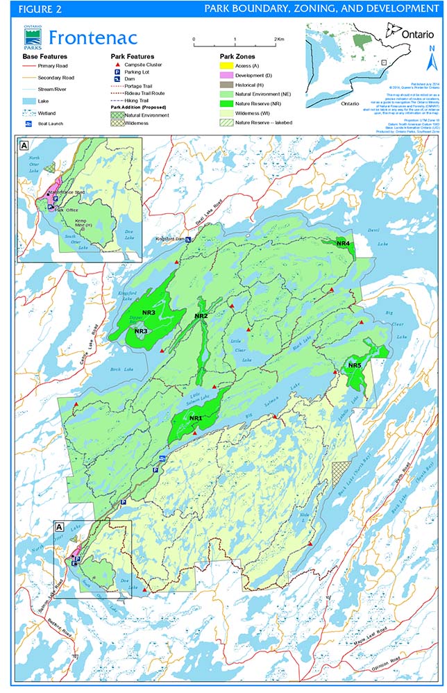
Enlarge Figure 2: Park boundary, zoning and development map (PDF, 10MB).
9.0 Park policies
This section provides site specific management policies and any associated actions required to effectively manage Frontenac Provincial Park in accordance with the PPCRA, policies for natural environment class parks and all other relevant legislation and provincial policies.
9.1 Industrial uses
The following activities are prohibited in Frontenac Provincial Park according to the PPCRA:
- Commercial timber harvest
- Prospecting, staking of mining claims, developing mineral interests, and working mines
- Extraction of aggregate (e.g. sand, gravel, bedrock, minerals), topsoil or peat
- Generation of electricity
- Other industrial uses.
9.2 Commercial uses
- Commercial Trapping: There are no existing licenses. New operations will not be permitted.
- Commercial Fishing: There are no existing licenses. New operations will not be permitted.
- Commercial Baitfishing: There are active baitfish harvesting licenses that include the park’s boundary lakes. There are no existing licenses on lakes enclosed by the park. New operations will not be permitted.
- Commercial Bear Management Area(s) (BMA): There are no existing licences (the park is excluded from surrounding BMAs). No new operations will be permitted.
9.3 Adaptive management
- An adaptive management approach will be applied to resource management activities within Frontenac Provincial Park.
- Adaptive management allows for modification of management strategies as needed in response to monitoring and analysis of the results of past actions and experiences.
- Adaptive management is a systematic, practical approach to improving resource management.
9.4 Resource management policies
- The following policies will guide the management of Frontenac Provincial Park’s resources, in accordance with broad and species-specific provincial policies and management strategies for southeast zone parks.
9.4.1 Land management
- Land management will be directed toward sustaining natural ecological processes on the landscape.
- Clear marking of the park boundary will be considered to maintain park interests and ensure good relations with neighbouring property owners, using an appropriate means (e.g., cutting vegetation as part of a boundary survey if not ecologically significant, signs, etc.) at areas such as:
- Park road entrance off Big Salmon Lake Road;
- South Otter Lake / Doe Lake, including the lands east of Doe Lake;
- Clear Lake Road;
- Labelle Lake, including the disjunct parcel of park land between Big Clear and Milk Lake; and
- Arkon Lake south to Big Salmon Lake Road.
- Frontenac Provincial Park is within the Township of South Frontenac in Frontenac County. Through the Ministry of Municipal Affairs and Housing, MNRF will recommend that the municipality ensure that their Official Plan appropriately identifies the park’s lands, waters, and significant values. This will allow new development or site alteration adjacent to the park to be assessed with regard to any potential impacts on the park’s natural heritage features and areas in accordance with the Provincial Policy Statement under the Planning Act.
- High beaver activity influences the water level of the park’s interior wetlands on a continuous basis, and occasionally floods roads within or adjacent to the park. Where necessary, the park superintendent will work with municipalities and the Ontario Ministry of Transportation (MTO) to minimize, control, and mitigate the impact of flooding. Policies for animal population control are found in Section 9.4.8.
- There are numerous known abandoned mine sites in the park originating from the mid-1800s, including several that were commercial operations (Barber 1997, Scheinman 2002). Those mines will be left for nature to reclaim, although for safety purposes, access to all pits, shafts, and addits will be closed and rehabilitated, as funding permits, consistent with the Mining Act.
- There are at least eight known abandoned, historic wells in the park. As funding permits, abandoned wells will be sealed and plugged consistent with the Ontario Water Resources Act.
- Ontario Parks will out-source all aggregate required for use in the park. Aggregate that may be left-over from other in-park construction activities may be used.
- Structures required for park management and operational needs may be considered.
Private recreation camps and boat caches
- There are no land use permits or other forms of private recreational land tenure within the park, and none will be permitted within the park in the future.
- Boat caches are not permitted within the park.
Commercial tourist operations and boat caches
- In keeping with the "Threshold Wilderness" concept, there are no commercial tourist operations or associated boat caches within the park. These and other commercial tourist activities are not permitted.
9.4.2 Water management
- No dams or weirs will be built in the park.
- Wherever possible, new park infrastructure development or redevelopment will be undertaken so as not to disrupt natural drainage. Wherever possible, natural drainage will be restored where it has been disrupted by past or present development.
9.4.3 Alien and invasive species
- Alien species are plants, animals and micro-organisms that have been unintentionally or deliberately introduced by human activity into areas beyond their natural past or present distribution. Alien species will not be deliberately introduced.
- Invasive species are those alien species whose introduction or spread threatens the environment, the economy and/or society, including human health. Where possible, actions will be taken to eliminate or reduce the threat of invasive alien species which may be affecting the diversity of naturally occurring populations.
- Where alien species already are established and threaten natural or cultural values, a program of control may be undertaken, if feasible and practical.
- Inventory and monitoring activities will incorporate measures designed to detect occurrences of alien species and invasive species (also see Section 9.4.7).
- To the extent possible, park staff will inspect any aggregate or fill brought into the park to ensure that no invasive species are inadvertently introduced into the park.
9.4.4 Insects and diseases
- Native insects and diseases will be allowed to progress naturally, except where they threaten significant natural heritage values, park biodiversity or park features, in which case they may be controlled.
- Where control is undertaken, it will be directed as narrowly as possible to the specific insect or disease, so as to have minimal effects on the rest of the park’s environment.
- Non-chemical and species-specific controls will be used whenever possible.
9.4.5 Fire management
Frontenac Provincial Park is located within the Great Lakes St. Lawrence Forest Region of Ontario. In this forest region, the MNRF recognizes fire as an essential ecosystem process, fundamental to restoring and maintaining the ecological integrity of protected areas.
The Great Lakes St. Lawrence Forest Region is a transitional landscape between boreal and deciduous forests, where frequent low-intensity surface fires predominate while higher-intensity, stand-replacing fires occur at much longer intervals (Van Sleeuwen 2006). Within Frontenac Provincial Park, the mature maple-oak forest landscape across the northern part of the park is a mixture of fire-sensitive sugar maple and relatively fire-tolerant oaks; in the absence of fire, the shade-sensitive oaks would be lost through succession favouring maples. Tolerant and mixed hardwood stands, such as young sugar maple and ironwood communities that dominate the middle portions of the park, have low combustible rates, but are highly subject to changes in community composition following a burn. Periodic fire would maintain, and possibly expand, the rock barren communities across the southern part of the park.
Ontario’s Wildland Fire Management Strategy (OMNRF 2014) provides strategic direction for managing wildfire across the province. Northern portions of Frontenac Provincial Park are located in the Northeast Fire Region; the remainder of the park is located Outside Fire Region.
- In the Northeast Fire Region forest fire response and management is the responsibility of MNRF.
- Outside Fire Region municipalities have a mandate to provide forest fire protection. The South Frontenac Fire Department is responsible for fire protection and response (southern portions of the park). MNRF fire management may support the fire department in severe or extraordinary fire situations.
Fire management objectives within Frontenac Provincial Park will focus on preventing personal injury, value loss and social disruption. In addition, the park may consider using fire management techniques to perpetuate naturally occurring vegetation communities and to help to restore and maintain ecological integrity (e.g., by helping to control or eradicate invasive species).
Fire management objectives in the park will be achieved as follows:
- Fire evacuation procedures will be as outlined in the Fire Emergency and Evacuation Plan for Frontenac Provincial Park.
- Fires that pose a threat to public health and safety, property and infrastructure, or other values are a priority for suppression.
- Consistent with the Ontario FireSmart program, forest fire hazard identification and risk assessment will be completed for infrastructure and steps will be taken to reduce or mitigate the threat posed by fire.
- "Light on the land" fire suppression techniques will be used whenever feasible. These minimal impact suppression techniques do not unduly disturb natural or cultural values. Examples may include limiting the use of heavy equipment or the felling of trees during fire response.
- Prescribed burning to achieve ecological or hazard reduction objectives may be considered. Plans for any prescribed burn will be developed in accordance with the MNRF Policy.
- Partial or total fire bans may be set in place in the park at the discretion of the park superintendent following consultation with MNRF Fire personnel and the local municipal fire departments.
9.4.6 Species at risk
- Species at risk and their habitats will be protected consistent with the ESA and associated regulations.
- Existing populations may be augmented, and extirpated native species may be reintroduced, if biologically feasible and desirable for perpetuating park values and maintaining or enhancing ecological integrity.
- Frontenac Provincial Park has 35 species at risk and 14 other provincially significant species. Populations of species at risk and rare plants and animals will be inventoried, assessed and monitored on a priority basis.
- The park may undertake management actions for species at risk, as supported by research and directed through approved recovery strategies and government response statements or other species-specific management plans.
- The ESA directs that a recovery strategy be in place for all "endangered" and "threatened" species. Provincial recovery strategies will guide species at risk management at Frontenac Provincial Park.
- Recommendations from these and future strategies will be implemented on a priority basis and as required.
- Ontario Parks will continue to screen all applications for research in the park. Research by qualified groups, institutions, or individuals that is related to the protection and recovery of species at risk will be encouraged (see also Section 9.4.12 and Section 9.4.13).
9.4.7 Vegetation management
- Vegetation management will be directed toward promoting the health and diversity of natural vegetation communities, particularly within nature reserve and natural environment zones.
- Plants and seeds may not be collected in the park by anyone other than Ontario Parks staff, unless they receive written authorization (Section 9.4.12).
- Management of invasive plant species will follow existing best management practices and provincial guidelines and policies (see also Section 9.4.3).
- Where planting or seeding is necessary, use will be made of species native to the park, and sources of these species that originate within the park or local ecodistricts.
Hazard trees
- Selective cutting of hazard trees, such as those adjacent to trails, interior campsites, or development and access zones may be carried out by Ontario Parks.
- With safety taking precedence, dead standing trees will only be removed if they pose a threat to health and safety or interfere with regular park operations as they provide important habitat for wildlife and contribute to ecological processes.
- Trees and brush cut in nature reserve, natural environment, wilderness, and historical zones will be left to deteriorate naturally as close as possible to where they have been felled. In development and access zones, where natural deterioration may not be feasible, cut trees and brush may be chipped on site and either blown back onto the forest floor or removed for use elsewhere in the park.
- Dead or dying trees that are infested with insects or disease and threatening park values may be cut, chipped, and removed from the park and disposed off-site at local landfills in order to reduce or eliminate the spread of infestation in the park. In backcountry areas where removal and disposal is not feasible, diseased wood may be burned on site.
- In cases of extreme weather events like ice or wind storms, clean up and salvage operations will follow provincial guidelines.
- Windthrown trees will be left to decompose naturally, unless they pose a threat to health or safety, or interfere with regular park operations.
Herbicide application and use
- Mechanical and other non-chemical forms of vegetation removal will be the preferred alternative to chemical herbicides, and will be used wherever feasible.
- All herbicide use must be in accordance with park policy and the Pesticides Act.
- Any proposed programs for pest control in the park will require consultation with Ontario Parks.
- Under exceptional circumstances, where pesticides provide the only feasible option for control, chemicals that have low or no soil activity and for which environmental impacts have been well-tested and shown to be minimal, may be used. In these circumstances, chemical pesticides and suppressants will not be used for any vegetation management other than:
- Insect and disease control, and fire suppression;
- Eradication of alien and invasive species, where it has been demonstrated that other methods with less residual impact on the park’s environment are not feasible; and
- Control of poison ivy to ensure visitor health and safety within the development zone, day use areas, park trails and campsites.
- Spraying will be done in a manner that minimizes risks to park staff, visitors, and wildlife. Whenever possible, spraying will be completed during non-peak visitation periods.
Deadfall collection
- Although firewood is sold at the park office, visitors collect deadfall in areas adjacent to campsites. Deadfall collection may have some negative impacts on both live vegetation – through trampling and alteration of the natural forest floor community – and the amount and distribution of local woody debris and deadfall. Some wildlife are also dependent on this dead wood and it is an essential component of a healthy forest ecosystem.
- Ontario Parks will continue to monitor interior camping impacts – including deadfall collection – on the vegetation around campsites, while encouraging and promoting the use of refillable stoves for cooking.
- Visitors will be educated on the importance of dead wood to the forest ecosystem, in an effort to minimize deadfall collection by campers.
9.4.8 Wildlife management
- Wildlife management will be directed toward promoting healthy populations and diverse communities, and will follow species-specific policies and management plans where they exist (including recovery plans).
- Where necessary, wildlife management may occur in the park to address human-wildlife conflicts (i.e., in order to protect human health and safety) or park infrastructure. Conflicts that have arisen between visitors and healthy native animals mainly due to visitor behaviour such as feeding and littering and not considered as endangering human health and safety will normally be dealt with through visitor education rather than animal control.
- Wildlife populations or individual problem wildlife may be controlled, as required, in order to protect ecological integrity, natural heritage values, the health of other species inside or outside the park, or the values for which the park has been established.
- Monitoring has demonstrated that the number of white-tailed deer in the park are changing vegetation communities and affecting biodiversity. Ontario Parks may work with the MNRF Peterborough and Kemptville Districts to determine deer management options in the surrounding landscape. Long-term monitoring of the impacts of deer browse on park vegetation will continue.
- Where wildlife control is necessary, techniques will be used having minimal effects on other components of the park’s environment.
- Appropriate methods of wildlife population control may be undertaken directly by Ontario Parks, or through partnerships under the supervision of Ontario Parks.
9.4.9 Fisheries management
- Direction for fisheries management is presented in A New Ecological Framework for Recreational Fisheries Management in Ontario (OMNR 2005a). At a smaller scale within the landscape, Frontenac Provincial Park encompasses the headwaters of a larger watershed within Fisheries Management Zone 18.
- Fisheries management within Frontenac Provincial Park will focus on achieving a healthy and diverse natural environment.
- Fisheries management decisions for the park and its boundary lakes are led by the MNRF Peterborough District. MNRF District and park staff will continue to work collaboratively to maintain and/or enhance native and/or self-sustaining fish populations and their habitat within the park boundary.
- Policies for commercial fish and bait harvest are listed in Section 9.2.
- Shoreline development (e.g., campsites) and other park projects will require prior consideration of potential impacts on fish and fish habitat.
- MNRF Peterborough District may continue to stock speckled trout (also called brook trout) in Clearwater, Moulton, and Tetsmine Lakes within the park for the purpose of providing opportunities for recreational fishing; however the impact of stocking, on native fish populations, must be considered.
- Park visitor education will be used to increase awareness of good angling practices, as outlined in the Regulatory Guidelines for Bait and Gear Restrictions (2006) and the annual Ontario Recreational Fishing Regulations Summary.
- The Provincial Bait Policy Review, underway at the time of management planning, will determine how the ecological risks associated with the movement and use of bait can be minimized to help maintain healthy fisheries across the province.
Within the boundary of Frontenac Provincial Park there are seven cold-water lakes. The remaining lakes in the park are classified as warm-water.
- Since the Rideau Lakes Fisheries Assessment Unit closed in 1995, no assessment of fish populations and pressures has been conducted in the park, and relatively little is known about the park’s fisheries. Park staff, with assistance from Ontario Parks Southeast Zone and MNRF fisheries biologists, may undertake additional fisheries assessment or the enhancement, rehabilitation, restoration or management of habitat.
9.4.10 Cultural heritage resources management
- MNRF/Ontario Parks will work with the Algonquins of Ontario and other Indigenous communities to identify and map Indigenous values within the regulated and proposed park boundary area.
- A Stage 1 archaeological assessment with an appropriate focus on pre-contact history and culture was completed for the park in 2014 (Central Archaeology 2014). The report concluded potential for pre-contact and historic Indigeonous archaeological resources within the park, based on landscape features including water features, topography, geology, and possible temporary use post-contact (Section 7.1.3).
- Cultural heritage resources that may be impacted by any provincial park projects and/or activities shall be identified and managed (i.e., protected, maintained, used and disposed of) in accordance with MNRF's Technical Guideline for Cultural Heritage Resources (OMNR 2006) and other relevant cultural heritage documents.
- Protection and management will be undertaken in consultation with Indigenous communities and the Ministry of Tourism, Culture and Sport, as appropriate.
- Decisions on activities that may affect cultural heritage resources shall be based on appropriate studies and research (including analysis of physical, documentary and oral evidence) aimed at understanding the cultural heritage resource, including its level of significance (e.g., local, regional, provincial), the impact of proposed activities on the value, and measures to mitigate these impacts.
- Management strategies for archaeological or other cultural heritage resources in the park may range from allowing the resource to evolve without human interference, to research, excavation, and rehabilitation.
- Built cultural resources within the park – such as foundations, cabins, mines, and fence lines – are being overgrown by vegetation and are rapidly deteriorating. In general, these cultural heritage resources will be left to deteriorate naturally. If resources permit, action may be taken to maintain the visibility of some of these resources by vegetation removal or ensure their persistence through restoration.
- A photo documentary of the park’s cultural heritage resources was prepared in the early 1980s, and The Friends of Frontenac Park have verified the locations of many of these resources. The photo record will be updated to help track the status of the park’s existing cultural heritage resources.
- The importance of the park’s cultural heritage resources may be emphasized to the public through educational media, including:
- Posts adjacent to historic sites, numbered to correspond to descriptions in pamphlets or trail guides that explain the significance of each site;
- A "Historical Corner" article series in the park tabloid; and / or
- Historical hikes and interpretive walks.
- If cultural heritage resources are discovered during a project, the project will be stopped until their significance and vulnerability are assessed and mitigation measures have been established.
9.4.11 Scientific collecting
- The scientific collection of fossils, rocks, minerals, archaeological/cultural artifacts, plants, seeds and animals may be permitted subject to authorization.
9.4.12 Research
- Scientific research by qualified individuals contributing to the knowledge of natural and cultural heritage resources and environmental management and are compatible and complementary to the protection of resources and/or recreational uses will be encouraged.
- Research activities require authorization issued under the PPCRA, consistent with relevant policies. Research must also meet all requirements under applicable provincial and federal legislation, and may require additional permits or approvals (e.g., MNRF Wildlife Scientific Collector authorization or ESA permits).
- Installations in support of approved research and monitoring activities may be considered.
- Sites altered by research activities will be rehabilitated as closely to their previous condition as possible.
- The following general fields of research are particularly appropriate to Frontenac Provincial Park and will be encouraged:
- Geology, landforms, vegetation, fish, wildlife, and settlement history of the park;
- Evolution of the park’s landscapes in relation to natural processes and past human activity;
- Ecological management in the park;
- Species at risk and other significant species and their habitats;
- Status of invasive species; and
- Optimal relationships between cultural heritage resource and natural heritage protection and recreation enjoyment within the park.
9.4.13 Inventory and monitoring
- Planning and management decisions will be made with the best available information and are intended to ensure the ecological sustainability of the park (including social and economic components).
- Inventory and monitoring will be undertaken as necessary, based on established methodologies and best practices.
- Monitoring projects may include:
- Effects of deer browse on park vegetation communities;
- Effects of beaver activity on recreational and ecological resources;
- Species at risk populations;
- Fisheries, particularly lake trout (Salvelinus namaycush) populations; and
- Effects of camping activity on surrounding vegetation communities.
9.5 Recreation management policies
9.5.1 Services for visitors
Current services for park visitors include firewood and a limited selection of Ontario Parks and The Friends of Frontenac Park merchandise. These are available for purchase at the park office. Park staff and volunteers provide one-on-one trip planning advice to visitors.
- If there is sufficient demand, additional services may be provided if they meet the goals and objectives of the park.
- Park visitors will continue to be directed to local businesses and tourist establishments for products and services such as groceries, paddling equipment rentals, and car campgrounds.
9.5.2 Fees
- Day-use, interior camping, and other fees – as determined by the MNRF - will be collected.
9.5.3 Hunting
- Hunting is prohibited under the PPCRA (i.e., hunting is not allowed by regulation under the Fish and Wildlife Conservation Act, 1997). See Section 3.0 for information regarding Aboriginal rights based activities.
9.5.4 Recreational fishing
- Recreational fishing is permitted subject to provincial and federal fisheries regulations (i.e., the Fish and Wildlife Conservation Act, 1997 and the federal Fisheries Act) as set out in the Ontario Recreational Fishing Regulations Summary.
- Motorized vehicle/vessel use to support recreational fishing is not permitted within the boating restriction areas of the park (Section 9.5.6) or on park lands.
- The Provincial Bait Policy Review underway at the time of management planning will determine how the ecological risks associated with the movement and use of bait can be minimized to help maintain healthy fisheries across the province.
9.5.5 Backcountry travel
- Park trails are for pedestrian travel only, such as hiking, portaging, snowshoeing and cross-country skiing. Motorized and mechanized travel, including mountain biking, is not permitted on park trails.
- Sections of the park’s cross-country ski trail network may be track set to a basic standard depending upon staff resources, equipment availability, public demand and snow conditions.
- Canoeing, kayaking, and limited motorized boating (Section 9.5.6) are permitted.
- Matching the number of interior campers with campsite supply is controlled by the Ontario Parks reservation system.
- Camping is permitted, year round, only on tent pads within designated sites.
- Visitors will be encouraged to use re-fillable, portable stoves for cooking, to reduce impacts on the park’s dead wood, incidence of accidental fires and the accumulation of non-refillable containers.
- A conservation philosophy of recycling, 'pack-in, pack-out and take home' will be promoted to all park users, to reduce garbage accumulation within the park interior. Litter bags are made available at the park office.
- Ontario Parks may propose an amendment to existing regulations under the PPCRA to prohibit the possession of non-burnable food or beverage containers in the park, if there is a need to reduce garbage accumulation and hazards from broken glass and metal.
9.5.6 Mechanized travel and equipment
- Snowmobiles, all-terrain vehicles and aircraft takeoff and landing will not be permitted in the park.
- Ontario Parks may use motorized vehicles (e.g., motorboats, motor vehicles, snowmobiles, all-terrain vehicles, aircraft) in the park to the extent necessary for efficient park management operations or for the purpose of conducting research safely and efficiently, provided their use does not compromise park values or visitor enjoyment of the park.
- In approving research applications (Section 9.4.12), the park superintendent may authorize researchers to use motorized vehicles or vessels in the park to the extent necessary to conduct research safely and efficiently.
- Emergency response personnel may use motorized vehicles to the extent necessary for emergency purposes (Section 9.6.1).
- All bicycles are restricted to the established park roads within the development and access zones.
- An existing regulation under the PPCRA prohibits the use of power tools in Frontenac Provincial Park – such as powered ice augers, chainsaws, and generators – except for their use by park staff for maintenance, management, safety, research, and resource management and protection purposes.
Power Boating
- Lakes not wholly enclosed within the park boundary (Birch, Kingsford, Devil, Big Clear, Buck, and South Otter Lakes) allow power boating. Boating on these lakes is subject to federal and provincial regulations.
- Power boating is prohibited from all lakes that are wholly enclosed by the park boundary, with the exception of boats propelled by an electric motor on Big Salmon Lake.
- The lakebed of Dipper Bay (off Birch Lake) is within a nature reserve zone. If issues arise that threaten ecological integrity, Ontario Parks may propose an amendment to existing regulations under the PPCRA to prohibit power boating in this bay.
9.5.7 Other recreational uses
- The following recreational activities are permitted within the park:
- Sailing and sailboarding (wind or muscle-powered)
- Skin diving (i.e., snorkelling).
- The following recreational activities will not be permitted:
- Spelunking (i.e., caving)
- Cliff diving or jumping
- Hang gliding
- War games
- Adventure racing
- Scuba diving
- Rock or ice climbing
- Riding horses, ponies, or similar domestic animals.
- New or emerging recreational activities will be considered on a case by case basis, provided they are consistent with maintaining the values of the park and comply with policies on permitted activities.
9.6 Operations policies
- A park operations implementation plan will be prepared to provide direction required to operate the park.
- In addition to addressing the operations policies that follow, the plan will include such topics as budget, staffing, maintenance schedules, enforcement, and emergency services.
- The provisions of the plan will be consistent with the approved Ontario Provincial Parks Minimum Operating Standards, and will be reviewed annually and updated as required.
- Self-serve registration facilities may continue to be used, and individual volunteers and partner organizations may help deliver park programs, to ensure that park operations continue to meet the standards of the park operating plan.
- Where possible, park operations will minimize environmental impacts. This could be accomplished in part by reducing energy use, noise and light pollution and vehicle emissions.
- Sewage from buildings in the development zone will continue to be managed in sewage treatment systems within this zone. Sewage from vault privies will be removed from the park by an approved/licensed hauler for disposal off-site.
- Waste from the park’s composting toilet and privies will be disposed of in accordance with Ontario Parks' Operations & Maintenance Manual for Class 1 & 2 Sewage Systems.
- The park will continue to encourage visitors to separate recyclables from waste, and deposit these into the appropriate receptacles provided.
- Campers will continue to be encouraged to take home their used propane cylinders, as these are considered hazardous waste.
9.6.1 Emergency response
- The park will maintain an up-to-date emergency response plan. Park staff will provide assistance to the Ontario Provincial Police, ambulance services, local by-law officers, and the municipal Fire Department in times of emergency within the park.
- Any public emergency response agency may use any craft or vehicle for emergency rescues or evacuations in the park.
- Emergency contact information is posted at the public phone outside the park office.
9.6.2 Education
- Provincial parks have a role in supporting the education objective in the PPCRA. The manner in which that objective is met will vary for each park and may be adapted based on the park’s resources and MNRF's direction and priorities at that time.
- In 2007, Frontenac Provincial Park’s education program designation was changed from major activity to self-use. There is currently no designated education staff working at Frontenac Provincial Park. The park receives support from senior education staff at Charleston Lake Provincial Park. As of preparation of this plan programming included three components: information, interpretation and outdoor recreation.
Information
- The information component of the park’s education program consists of a library of outdoor educational resources at the park office. Ontario Parks' educational materials will be supplied at the park office.
Park interpretation
- The park interpretation component of the education program will consist of visual displays at the park office and the Frontenac Park Interior Routes map. The park’s themes are ecology, geology, past settlement history, and "Threshold Wilderness" (Section 5.2).
- Additional interpretive information will be disseminated to park visitors through trail guides, park tabloids, and brochures, as well as through informal communications with park staff and volunteers.
- Interpretive signage or promotional material recognizing Indigenous people’s history and culture will be developed to enhance appreciation and understanding of the area’s cultural heritage. Ontario Parks may work with local Indigenous communities to prepare mutually acceptable interpretive information.
- Dependent on available resources and funding, emphasis may be given to:
- Exploring ways to further interpret the park’s cultural heritage resources and to increase public knowledge and appreciation of the park’s European settlement history, including interpreting these resources in a field setting;
- Updating the visual displays and interpretive panels at the park office;
- Producing additional individual interpretive trail guides;
- Input and production of the annual park tabloid;
- Providing information about the park’s role in the Frontenac Arch Biosphere; and
- Promoting winter and off-season interest in the park.
Outdoor recreation programs
- Frontenac Provincial Park offers wilderness skills training programmes.
- Most wilderness skills events are currently presented by The Friends of Frontenac Park or by qualified individuals or organizations outside the park, as selected by the park superintendent.
9.6.3 Partnerships
- Ontario Parks may pursue opportunities for partnerships involving other agencies and groups through both formal and informal partnership agreements.
- Partners may represent the local community, and local and provincial interests.
- Partners will work with Ontario Parks to assist with the implementation of the park management plan and follow provincial park policies, guidelines, and regulations.
- Ontario Parks will continue its existing partnership with The Friends of Frontenac Park and may explore new opportunities with other agencies, community and interest groups, and the private sector. Such partnerships will be essential to achieving the park’s protection, heritage appreciation, recreation, and scientific research objectives.
- Ontario Parks will continue building relationships with the Algonquins of Ontario, through identification and interpretation of Indigenous values and continued engagement during implementation of the management plan.
The Friends of Frontenac Provincial Park
The Friends of Frontenac Park (The Friends) was established in 1992 as a volunteer cooperative association, and has since been very active in supporting education, interpretation, and research in the park. They have funded, organized and carried out trail maintenance in the park. In addition, The Friends have donated money to help in the purchase of adjacent land of interest to the park.
The mission statement for The Friends is to undertake activities appropriate to protect and enhance the natural qualities of Frontenac Provincial Park. In this capacity, The Friends develop and promote programmes and materials that will enhance the public’s awareness, education, and appreciation of the natural environment and human history of the park.
- Ontario Parks will continue to encourage and assist the growth and development of The Friends.
- Existing partnerships with The Friends that will continue include:
- Producing and funding interpretive and educational materials;
- Inventory and monitoring of the park’s life science and cultural resources;
- Funding and participating in trail maintenance and improvements;
- The park Host and Interior Trail Volunteer programs;
- Maintaining and updating The Friends promotional website;
- Hosting and organizing special events and Wilderness Skills Training Programme activities; and
- Off-site promotion of Frontenac Provincial Park.
9.7 Marketing and communications policies
9.7.1 Marketing
- Frontenac Provincial Park will be operated consistent with the overall marketing strategy of Ontario Parks.
9.7.2 Communications
- Communications regarding park policies and other information will be achieved through park tabloids, brochures, trail guides, signage, notices, websites, outside promotional media, and direct communication by park staff and The Friends of Frontenac Park.
9.8 Development policies
- All development undertaken by Ontario Parks, or by third parties, will comply with the Class EA-PPCR, and will be carried out in accordance with Ontario Parks approved site and development plans.
- Areas proposed for development will require prior assessment for significant cultural heritage resources and natural values - such as species at risk - to ensure these values are identified and protected.
- The location, design, and materials of all facilities will, as much as possible, reflect the natural character of the park. Durable, low maintenance, and energy efficient designs and materials will be used whenever possible.
- Utility corridors will be discouraged within the park boundary.
9.8.1 Internal roads
The park has approximately 4 km of internal roads open to the public. From the park entrance, a paved section that can accommodate two-way traffic, leads to the park office and two parking areas. A 4 km single-lane gravel road, that is open from April until the end of October, leads to Big Salmon Lake, presently servicing two parking lots along the way.
- There will be no new roads developed in the park.
- Existing roads may be improved and maintained to provincial park operating standards within a 20 m right of way. Park roads will occupy only as much of the right of way as required to meet those standards.
- Where feasible, existing roads will be upgraded to minimize maintenance, erosion, flooding, traffic congestion, and other safety hazards (e.g. the main access road, referred to as Big Salmon Lake Road).
- Wildlife ecopassages may be incorporated within existing roads, where appropriate, to help reduce road mortality of herptiles and other small wildlife along Big Salmon Lake Road.
9.8.2 Parking areas
- The Big Salmon Lake parking lot will be enlarged.
- If resources permit, the Arab Lake and maintenance area parking lots may be enlarged and/or reconfigured.
9.8.3 Day-use
- To promote winter recreation and attract winter day use, park staff may track-set and groom cross-country ski trails along Big Salmon Lake Road and adjacent trails to encourage visitation by novice and intermediate-level skiers.
9.8.4 Layover campsites
- A small number (10 or fewer) walk-in, layover campsites may be developed in the vicinity of the park office (southwest corner of the park) in zones D, WI or NE (Section 8.0), as determined by a detailed site assessment.
- As much as possible, existing services near the park office – potable water, composting toilets, garbage / recycling bins, and parking lot – will service these campsites.
- The layover campsites will serve as a staging area for campers arriving at the park late in the day when travel to the designated site would occur after sunset. Use of the sites would typically be for one night only.
9.8.5 Backcountry campsites
- Ten (10) or fewer new individual campsites will be developed. Additional small campsite clusters may be considered.
- The number of campsites in the park will be increased gradually, and Ontario Parks will monitor any effects of increased camping use on park capacity and will maintain the integrity of the park’s "Threshold Wilderness" values.
- Park staff will continue to monitor group camping needs and, if a separate group campsite is necessary at Frontenac Provincial Park, a new site would be proposed through planning.
- Where feasible, existing non-composting privies will be converted to composting privies.
- Clusters may be provisioned with designated tree hangs, bear and racoon pole hangs, or lockers to allow safe food storage while minimizing negative impacts on park vegetation.
- Existing campsites may be temporarily or permanently closed for health, safety, or operational purposes, at the discretion of the park superintendent.
9.8.6 Trails and portages
Frontenac Provincial Park’s interior routes are organized into a network of over 100 linear kilometers of interconnected trails to support pedestrian travel and portaging. The park’s main hiking trails are organized into loops that spread throughout the park area, ranging from the 1.5 km Arab Lake Gorge boardwalk trail to the physically challenging 21 km Slide Lake Loop. Most trails can support increased use, with the exception of the popular 3 km Doe Lake Loop near the park office. Paddle routes in the park cover over 35 km across interior and boundary lakes, joined by over 10kms of portage trails.
- Several points of interest – such as lookouts, the Arkon ring bog, abandoned homesteads, and mines – are indicated on the park map. Interpretive signage may be installed along trails to highlight these sites.
- Trail layout will avoid sensitive features. Minor trail additions or relocations may occur, to protect park values or for health and safety reasons. New trails for short day hike excursions may be created to alleviate pressure on the park’s existing smaller trails.
- Erosion control devices will be installed where necessary.
9.8.7 Maintenance and administrative areas
- The park office is the only designated permit-issuing point of entry into the park, and includes the administrative area.
- Administrative and maintenance buildings and structures may be upgraded, reconfigured, or replaced and enlarged as required.
- The park’s water supply well has occasionally run dry in recent years (2002, 2003, and 2004). Another deep well will be constructed, and the potable water system will be upgraded to meet present demand and regulations.
- Facility upgrades may include developing new buildings or structures for:
- Water distribution and disinfection or storage;
- Garbage, recyclables, and other waste;
- Materials and equipment; and/or
- Firewood.
9.8.8 Roofed accommodation
- Rustic roofed accommodation (e.g., backcountry cabins) may be developed. Roofed accommodation facilities could be constructed in limited numbers on new sites within the park (up to 6 new sites) and on existing campsites where appropriate.
Table 1: Permitted/not permitted recreation activities and facilities by zone for Frontenac Provincial Park (natural environment class)
| Activities and Facilities | Zone NE | Zone D | Zone WI | Zone NR | Zone H | Zone A |
|---|---|---|---|---|---|---|
| All-terrain Vehicle (ATV) travel / Snowmobiling | Not permitted | Not permitted | Not permitted | Not permitted | Not permitted | Not permitted |
| Aircraft landing (water) – private | Not permitted | Not permitted | Not permitted | Not permitted | Not permitted | Not permitted |
| Boating (motorized): Park-enclosed lakes | May be permitted | Not permitted | Not permitted | Not permitted | Not permitted | Not permitted |
| Boating (motorized): Boundary lakes | Permitted | Permitted | Permitted | Permitted | Not permitted | Not permitted |
| Campsites: Layover site | May be permitted | May be permitted | May be permitted | Not permitted | Not permitted | Not permitted |
| Campsites: Backcountry clusters | Permitted | Not permitted | Permitted | Not permitted | Not permitted | Not permitted |
| Canoeing / kayaking | Permitted | Permitted | Permitted | Permitted | Not permitted | Permitted |
| Demonstration area (e.g. historical exhibit, etc.) | Not permitted | Not permitted | Not permitted | Not permitted | Permitted | Not permitted |
| Hiking | Permitted | Permitted | Permitted | Permitted | Permitted | Permitted |
| Historical appreciation – self-guided | Permitted | Permitted | Permitted | Permitted | Permitted | Permitted |
| Horseback riding | Not permitted | Not permitted | Not permitted | Not permitted | Not permitted | Not permitted |
| Mountain biking – Big Salmon Lake Road | Not permitted | Permitted | Not permitted | Not permitted | Not permitted | Permitted |
| Nature appreciation – self-guided | Permitted | Permitted | Permitted | Permitted | Permitted | Permitted |
| Painting / photography | Permitted | Permitted | Permitted | Permitted | Permitted | Permitted |
| Day use picnic areas | Not permitted | Permitted | Not permitted | Not permitted | Not permitted | Permitted |
| Rock or ice climbing / Cliff diving or jumping | Not permitted | Not permitted | Not permitted | Not permitted | Not permitted | Not permitted |
| Sailing / sailboarding (muscle-powered) | Permitted | Permitted | Not permitted | Not permitted | Not permitted | Permitted |
| Scuba diving | Not permitted | Not permitted | Not permitted | Not permitted | Not permitted | Not permitted |
| Skin diving (Snorkelling) | Permitted | Permitted | Permitted | Permitted | Not permitted | Permitted |
| Skiing (cross-country) / snowshoeing | Permitted | Permitted | Permitted | Permitted | Permitted | Permitted |
| Sport fishing | Permitted | Permitted | Permitted | Permitted | Not permitted | Permitted |
| Sport hunting | Not permitted | Not permitted | Not permitted | Not permitted | Not permitted | Not permitted |
10.0 Implementation priorities
- Park development, operations and resource management will be contingent upon the availability of funding and unforeseeable changes in priorities or policy. Implementation of the management plan and operation of the park will meet the requirements of the PPCRA and all other pertinent legislation and policies.
- All aspects of park management, development and operations will be undertaken in accordance with the requirements of the Class EA-PPCR.
- Park resource management, development and operations proposals will be phased in as follows, as resources permit:
10.1 Phase 1
Resource management projects
- Continue inventory and management of species at risk (Section 9.4.6 and 9.4.13), taking appropriate remedial action(s) as necessary.
- Undertake priority monitoring projects as listed in Section 9.4.13.
Operations projects
- Promote recycling and minimize waste by streamlining collection facilities toward having fewer receptacles at better locations (Section 9.8.7).
Development projects
- Re-configure the park office (Section 8.2), and the maintenance area (Section 9.8.7);
- Develop individual backcountry campsite(s) (Section 9.8.5); and
- Enlarge the Big Salmon Lake parking lot and enhance the other parking lots through re-configuration (Section 9.8.2)
10.2 Phase 2
Resource management projects
- Implement resource management where necessary, including vegetation management (Section 9.4.7), wildlife management (Section 9.4.8) and fisheries management (Section 9.4.9).
Development projects
- Develop roofed accommodation, starting with a few sites (Section 9.8.8); and
- Construct another deep well and upgrade the potable water system at the park office (Section 9.8.8).
11.0 Plan examination and adjustment
- This management plan will be examined in accordance with the provisions of the PPCRA to determine whether the management direction is still relevant, effective and current, or if an adjustment is required. In circumstances where this plan is not providing sufficient direction, it can be examined prior to the next scheduled examination.
- External requests for adjustments to address specific concerns may be considered. Ontario Parks can provide further guidance to external parties on the process for requesting an adjustment to this plan and whether specific requests can/will be considered. Amendments will be undertaken consistent with policy and will include opportunities for Indigenous community and public consultation.
12.0 References
Barber, C. 1997. Their Enduring Spirit: The History of Frontenac Provincial Park, 1783-1990. Quarry Press. 376 pp.
Crowder, A., J. Topping and K. Topping. 1997. Plants of the Kingston Region. Fowler Herbarium, Dept. of Biology, Queen’s University. Kingston.
Central Archaeology Group. 2014. Stage 1 Background Study for Frontenac Provincial Park in the Geographic Townships of Bedford and Loughborough, Frontenac County. Prepared for Ontario Parks, Southeast Zone. 75 pp.
Ecological Services Ltd. 2004. Detailed Evaluation of the Ecological (Life Science) Values at Frontenac Provincial Park and Assessment of Resource Management Issues Relating to These Values. Prepared for: Ontario Parks, South Eastern Zone, MNR, Kingston. 97 pp.
Ontario Ministry of Natural Resources and Forestry. Crown Land Use Policy Atlas
Ontario Ministry of Natural Resources. 1983. Napanee District Land Use Guidelines. Queen’s Printer for Ontario. 64 pp.
Ontario Ministry of Natural Resources. 1988. Napanee District Fisheries Management Plan 1988-2000: Background Information and Optional Strategies. 127 pp.
Ontario Ministry of Natural Resources. 1992 update. Ontario Provincial Parks: Planning and Management Policies. 90 pp. + appendices.
Ontario Ministry of Natural Resources. 2004. Marketing Plan: 2004-2007. Queen’s Printer for Ontario, Toronto. 33 pp.
Ontario Ministry of Natural Resources. 2005a. A Class Environmental Assessment for Provincial Parks and Conservation Reserves, Queen’s Printer for Ontario, 47 pp. + appendices.
Ontario Ministry of Natural Resources. 2005b. A New Ecological Framework for Recreational Fisheries Management in Ontario. Fisheries Section, Fish & Wildlife Branch. 16 pp. + appendix.
Ontario Ministry of Natural Resources. 2005c. Our Sustainable Future, Ministry of Natural Resources Strategic Directions, Queen’s Printer for Ontario, Toronto, 64 pp.
Ontario Ministry of Natural Resources. 2005d. Protecting What Sustains Us: Ontario’s Biodiversity Strategy, Queen’s Printer for Ontario, Toronto, 44 pp.
Ontario Ministry of Natural Resources. 2006. A Technical Guideline for Cultural Heritage Resources for Projects Planned Under the MNR Resource Stewardship and Development Projects and the Class Environmental Assessment for Provincial Parks and Conservation Reserves. 45 pp.
Ontario Ministry of Natural Resources. 2006. Guidelines for Modified Response and Monitoring during Managed Fire Operations. Ontario Ministry of Natural Resources, Queen’s Printer for Ontario, Toronto. 21 pp.
Ontario Ministry of Natural Resources. 2006. Regulatory Guidelines for Bait and Gear Restrictions. Fisheries Section, Fish and Wildlife Branch. 4 pp. + tables + glossary.
Ontario Ministry of Natural Resources and Forestry. 2014. Wildland Fire Management Strategy. Toronto: Queen’s Printer for Ontario. 28 pp.
Ontario Parks. 2015. Ontario Provincial Parks Statistics 2014. Queen’s Printer for Ontario, Toronto. 71 pp.
Ontario Parks, South Eastern Zone. 2005. Frontenac Provincial Park Background Information. 49 pp.
Ontario Parks, South Eastern Zone. 2005. Frontenac Provincial Park: Interior camping impact study. Compiled by: R. Clavering. 15 pp.
Past Recovery Archaeological Services Inc. 2015. Stage 2 Archaeological Assessment, Arab Lake Parking Lot, Frontenac Provincial Park, Lot 13 Concession 13, Geographic Township of Lougborough, now Township of South Frontenac, Frontenac County, Ontario. Report prepared for Ontario Parks, Kingston. 66 pp
Scheinman, A. 2002. Frontenac Provincial Park: Evaluation of Historical Zones. Report prepared for Ontario Parks, Kingston. 32 pp. + map.
Van Sleeuwen, M. 2006. Natural Fire Regimes in Ontario. Ontario Ministry of Natural Resources. 130 pp. + appendices.
White, David J. 1993. Life Science Areas of Natural and Scientific Interest in Site District 6-10. Report prepared for Ministry of Natural Resources, Kemptville and Tweed Districts. 122 pp.
Appendix 1 – Summary of involvement
Summary and results of Indigenous community consultation
- Indigenous community involvement is a very important part of the Frontenac Provincial Park management planning process.
- Notices were mailed to the Algonquins of Ontario and Mohawks of the Bay of Quinte and several Provincial Treaty Organizations at the Terms of Reference, the Background Information and the Management Options stage. No specific comments were received at those stages.
- Under the Consultation Process Interim Measures Agreement (2009) Ontario Parks consulted with the Algonquins of Ontario regarding the management planning process. Representatives of the Algonquins of Ontario met with Ontario Parks staff in 2010, 2012 and 2013 during preparation of the preliminary management plan. Algonquins of Ontario reviewed a draft preliminary management plan and provided written comments in 2011 and 2013. Those comments were considered and changes made to address the comments are reflected in this document. No additional comments were received from the Algonquins of Ontario following notice in June 2015 of the 45 day consultation opportunity for the approved preliminary management plan.
- A copy of the draft preliminary management plan was provided to the Mohawks of the Bay of Quinte in June 2014. No comments were received on the draft. The Mohawks of the Bay of Quinte were sent notice in June 2015 of the 45 day consultation opportunity for the approved preliminary management plan. The Mohawks of the Bay of Quinte indicated no concerns or comments.
Summary and results of public consultation
- Public involvement is a very important part of the Frontenac Provincial Park management planning process. Newspaper ads in local and regional media, postings on the Environmental Registry, and direct mailings notified participants when management planning documents were released. Documents were available on the Ontario Parks website. Ontario Parks staff at Frontenac Provincial Park and at the Southeast Zone office in Kingston also responded to individual enquiries by phone, mail, e-mail, or in person.
- Mailing lists included individuals / groups / agencies that responded to the Invitation to Participate, residents and corporate managers of adjacent lands, and new individuals who requested to be added to the mailing list (this is ongoing during the planning process). Contacts identified on the parks mailing list were also included.
- Terms of Reference (Invitation to Participate): The Terms of Reference for this park management planning project was approved in December 2001. In February 2002, the public was invited to participate in the process. One hundred thirty (130) respondents expressed interest in participating in the process; eleven provided detailed comments (nine individuals and two groups) which showed support for an accessible park where protection supersedes recreation.
- Background Information: A Background Information document was released in April 2005, and was followed by a 45-day consultation period. Seventeen detailed responses were received; these strongly supported maintaining the park’s "Threshold Wilderness" theme by minimizing development and overuse. This theme or concept embodies providing visitors with the opportunity to experience backcountry travel in a convenient location and semi-wilderness environment.
Management Options: At the end of February 2006, the Management Options document was released, which primarily focused consultation on four (4) management topics. A 45-day consultation period followed, during which 28 respondents (four interest groups, including outdoor clubs, schools, conservation organizations, and 24 individuals, including adjacent landowners and neighbours) submitted completed questionnaires with their preferences for the following topics:
- Is there sufficient vehicle parking space within the park?
53% no / 47% yes - Should Frontenac develop a walk-in campground?
66% yes / 34% no - Is there demand for a group campsite?
66% no / 34% yes - Is the proximity of campsites within clusters appropriate?
66% yes / 34% no
An additional five respondents, representing organizations, did not complete the questionnaire, but instead detailed their comments in a letter. These responses showed support for the "Threshold Wilderness" concept and also made reference to park access and entry control. An additional four respondents submitted a completed questionnaire after the consultation period.
- Is there sufficient vehicle parking space within the park?
- Preliminary Park Management Plan: In June 2015 the preliminary management plan was released for a 45 day comment period. Notice was posted on the Environmental Registry, local media and in the park office, and mailed to the project contact list. The preliminary management plan was available online. An open house was held at the park office on June 21, 2015. Seven responses were received during the comment period. All responses were considered during preparation of the final management plan. Three respondents expressed support for the park and/or some or all of the proposed policies; two of these respondents provided specific comments on two or more policies in the preliminary plan (e.g., cultural heritage resource protection, proposed new development). One response was a request that hunting by licenced hunters be considered within the park. One response was a request that changes be made to the cultural heritage policies to reflect recent standards and guidelines. Two other responses were either comments that were operational in nature or otherwise not applicable to the management planning process. No significant changes were made to the plan as a result of comments received.
Ontario Parks will retain on file reference copies of the Background Information, Preliminary Park Management Plan and the approved Park Management Plan documents.
Appendix 2 – Species list
Scientific names for the species listed by common name in Section 6.1 and Section 7.4 of the document are indicated in parentheses below.
Mammals:
White-tailed deer (Odocoileus virginianus)
Beaver (Castor canadensis)
Fish:
Speckled trout - also called brook trout (Salvelinus fontinalis)
Reptiles:
Four-toed salamander (Hemidactylium scutatum)
Spotted salamander (Ambystoma maculatum)
Northern two-lined salamander (Eurycea bislineata)
Pickerel frog (Rana palustris)
Black rat snake (Elaphe obsolete)
Plants:
Sugar maple (Acer saccharum)
Tamarack (Larix laricina)
Black spruce (Picea mariana)
Ironwood (Ostrya virginiana)
Butternut (Juglans cinerea)
Blunt-lobed Woodsia (Woodsia obtusa)
Poison ivy (Rhus radicans)
© 2016, Queen’s Printer for Ontario
Printed in Ontario, Canada
Additional copies of this publication are available at no charge from the Ministry of Natural Resources and Forestry:
Frontenac Provincial Park
Box 11
6700 Salmon Lake Road
Sydenham, Ontario K0H 2T0
Telephone: (613) 376-3489
62951 (Print)
62952 (HTML)
ISBN 978-1-4606-7567-0 (Print)
ISBN 978-1-4606-7568-7 (HTML)
Footnotes
- footnote[i] Back to paragraph There are no waters within the park’s H zone suitable for water based activities; such activities are not applicable in this zone.
- footnote[ii] Back to paragraph Electric motors are permitted on Big Salmon Lake only.