Gem Lake Maple Bedrock Provincial Park Management Statement
This document provides direction on the management of Gem Lake Maple Bedrock Provincial Park.
Interim Management Statement
2006
Approval statement
I am pleased to approve this Interim Management Statement for Gem Lake Maple Bedrock Provincial Park (P1632). The Ontario’s Living Legacy Land Use Strategy (1999) identified this area as a nature reserve class provincial park. Gem Lake Maple Bedrock Provincial Park was regulated in May of 2002 (O. Reg. 147/02) under the Provincial Parks Act (1990).
This Interim Management Statement provides direction for the protection and management of Gem Lake Maple Bedrock Provincial Park.
Signed by:
Paul Bewick
Zone Manager
Northeast Zone
Ontario Parks
Date: May 19, 2006
1.0 Introduction
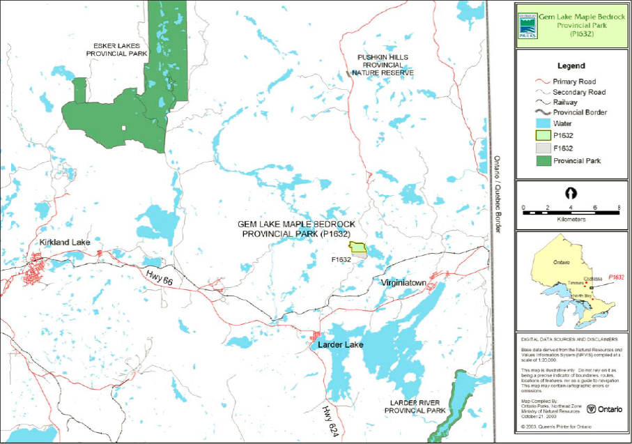
Gem Lake Maple Bedrock Provincial Park is a nature reserve class provincial park. The park is located approximately 40 kilometres east of Kirkland Lake, 15.6 km northwest of Virginiatown and 17 km northeast of the community of Larder Lake (Figure 1). Gem Lake Maple Bedrock Provincial Park contains 90 hectares of Crown land which has been regulated under the Provincial Parks Act as a nature reserve (O. Reg. 147/02) (Figure 2).
Gem Lake Maple Bedrock Forest Reserve provides the southern boundary for the nature reserve, Station Road lines the park’s eastern boundary, a warm water system of rivers, small lakes and ponds outline the parks western limit, and two small waterways outline the parks northern boundary.
This nature reserve class park represents distinct natural habitats and landforms within this region of Ontario. The park may provide opportunities for education and research, which will benefit both present and future generations.
1.1 Objectives
Gem Lake Maple Bedrock Provincial Park will be managed consistent with the four objectives for provincial parks:
Protection: To protect provincially significant elements of the natural and cultural landscapes of Ontario.
Recreation: To provide provincial park outdoor recreation opportunities ranging from high-intensity day-use to low-intensity wilderness experiences.
Heritage Appreciation: To provide opportunities for exploration and appreciation of the outdoor natural and cultural heritage of Ontario.
Tourism: To provide Ontario’s residents and out-of-province visitors with opportunities to discover and experience the distinctive regions of the Province.
2.0 Management context
This Interim Management Statement (IMS) provides direction for custodial management of park resources. The direction for resource stewardship, permitted uses, development and operations will be reviewed during future management planning as required.
Park management will follow direction from:
- Ontario’s Living Legacy Land Use Strategy (OMNR 1999), policy clarification amendments (OMNR 2000) and related direction
- Ontario Provincial Parks Planning and Management Policies (OMNR 1992) and updates
- Ontario Crown Land Use Policy Atlas (OMNR 2004)
- Provincial Parks Act, RSO 1990, and regulations.
In addressing custodial management obligations to protect park values and ensure public health and safety, Ontario Parks will ensure that policy and Environmental Assessment Act requirements are implemented.
The park superintendent will implement the policies, procedures and legislation that are derived from the above direction and written into this IMS.
Figure 1: Regional Setting

Enlarge Figure 1: Regional Setting
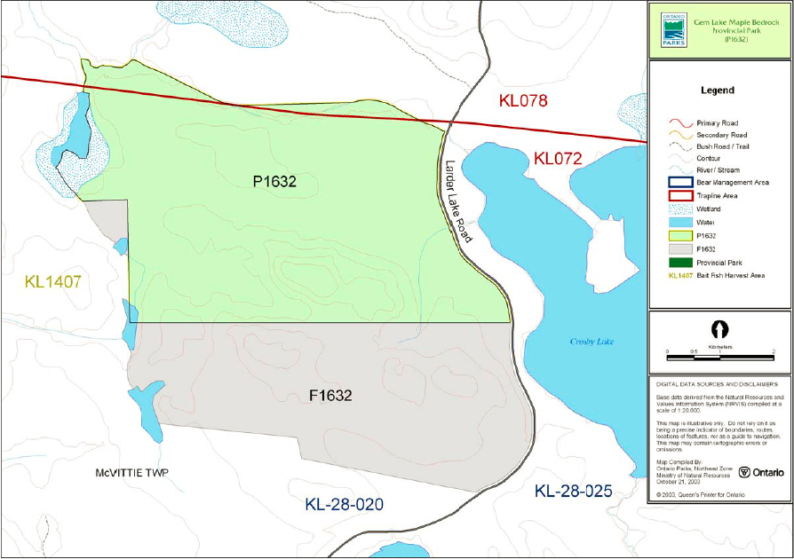
Figure 2: Park Boundary / Bear Management Areas/ Trap lines / Bait Fish Areas

Enlarge Figure 2: Park Boundary / Bear Management Areas/ Trap lines / Bait Fish Areas
2.1 Environmental Assessment
As part of the Ontario Ministry of Natural Resources (MNR), Ontario Parks is a public sector agency that is subject to the Environmental Assessment Act. Park management will be carried out in accordance with legislation, policies and the MNR A Class Environmental Assessment for Provincial Parks and Conservation Reserves (OMNR 2005).
3.0 Park features and values
Gem Lake Maple Bedrock Provincial Park protects representative ecosystems and landforms in Ecodistrict 3E-6. The park plays an important role in the protection and preservation of the Maple Bedrock Uplands. The area is dominated by maple uplands encompassed by nutrient poor to nutrient rich conifer stands and low lying intolerant hardwoods. There are also several open wetlands and one bedrock outcrop within the park.
3.1 Geological features
The park is located within the western Abitibi Subprovince of the Archean Superior Province.
The bedrock of the park consists of massive and pillowed meta-basalt flows and part of the large Crosby Lake hornblende gabbro sill, components of the Kinojevis South supracrustal assemblage of the Abitibi greenstone belt. The 2.7 billion year old Kinojevis South assemblage is highly folded and contains numerous felsic and mafic intrusions. The Crosby Lake sill within the park is greater than 200 m in stratigraphic thickness (Frey and Duba 2003).
The geological environments of the park and adjacent Forest Reserve are a part of the modern organization of the complex products of late Archean orogenic events in the Superior Province (Jackson and Fyon 1991). Their representation contributes to the conservation of the "Early Archean Basement" and "Late Archean Volcanic Islands and Sedimentary Basins" Precambrian environment themes outlined by Davidson (1981) (Frey and Duba 2003).
Sandy ground moraine till was deposited approximately 11,000 years ago by the southeastward advancing Superior Lobe of the continental ice sheet. The till is overlain or replaced by sandy and finer grained glaciolacustrine deposits across most of the park. The bedrock uplands have a very thin, discontinuous till cover. The lacustrine sediments were deposited approximately 9,000 to 8,000 years ago, when proglacial Lake Barlow flooded the area during the northward recession of the Superior Lobe. These features represent the Quaternary Algonquin Stadial and Timiscaming Interstadial environmental themes of Davidson (1981) (Frey and Duba 2003).
Within the Ontario Provincial Park system, the bedrock geology of the Gem Lake Maple Bedrock Provincial Park has regional significance in its representation of the Kinojevis South assemblage of the Abitibi greenstone belt. Surficial geology is locally significant (Frey and Duba 2003).
3.2 Biological features
The species inhabiting Gem Lake Maple Bedrock Provincial Park are typical of those found within the Boreal Forest (Alkins 2003). The area is dominated by maple uplands encompassed by nutrient poor to nutrient rich conifer stands, and low lying intolerant hardwoods. There are several open wetlands and one bedrock outcrop. Four landform vegetation types were identified. These include dominant, medium-aged red/silver maple, poplar, open muskeg on weakly broken bedrock and exposed bedrock. The park’s wetland communities range from open wetland to brush/alder transition zones (Alkins 2003).
Natural Resource Values Inventory System (NRVIS) data revealed moose aquatic feeding areas (within the park. Moose and white-tailed deer wintering, calving and feeding, as well as warm water fisheries habitat (Crosby and Monocle lakes) also exist in the immediate surrounding area. The park lies within the Atlantic and Englehart River Watersheds. A small creek connects several small lakes and ponds along the western boundary of the park. These water bodies are considered moderate moose aquatic feeding areas (Alkins 2003).
3.3 Cultural setting
No detailed survey or analysis of the cultural history and features of this park have been conducted to date.
Future planning for cultural heritage will be done within the context of the provincial framework, A Topical Organization of Ontario History (OMNR 1974). Planning will also involve updates and discussions with other agencies, First Nation communities and interest groups to identify cultural heritage values and features, and their significance, within the park. This information may be used to develop management guidelines to conserve and protect representative archaeological or historical values and features, and to provide direction for further research.
3.4 Recreation
The protection and maintenance of environmental quality and values are fundamental to the management of Gem Lake Maple Bedrock Provincial Park. Nature reserve policies ensure that natural processes are allowed to function freely, within the constraints of public safety and the need to protect values within and adjacent to the nature reserve.
There are no known recreational activities occurring within this park at present. There are no visible trails or navigable rivers/creeks within the park boundaries.
The bedrock outcrop and maple forest are the park’s most significant recreational features (Carré, 2002). Low-intensity recreation such as walking and hiking are complementary activities for this nature reserve.
4.0 Aboriginal uses
Gem Lake Maple Bedrock Provincial Park is within the Robinson-Huron Treaty (1850) area and is located east of the Matachewan Indian Reserve.
First Nations have expressed interest in and have shared knowledge of the park and surrounding area. Aboriginal communities have used the area for hunting, trapping, fishing, gathering and travel. These uses may continue, subject to public safety, conservation and other considerations.
Any communications and cooperation between Aboriginal communities and the MNR for planning and operations purposes will be done without prejudice to any future discussions or negotiations between the government of Ontario and Aboriginal communities.
5.0 Stewardship policies
5.1 Terrestrial ecosystems
The removal, damage or defacement of Crown property, natural objects, relics and artifacts is not permitted in provincial parks (Provincial Parks Act 1990).
5.1.1 Vegetation
Harvesting
Commercial forest harvesting and renewal activities are not permitted within the boundaries of this nature reserve provincial park (OMNR 1992; 2004).
There are no fuelwood cutting permits currently issued within the boundaries of Gem Lake Maple Bedrock Provincial Park. No new permits will be issued (OMNR 2000).
The commercial harvest of non-timber forest products (e.g. wild rice, club moss, Canada yew) will not be permitted within the boundary of Gem Lake Maple Bedrock Provincial Park (OMNR 1992).
Non-native plants
Non-native plant species will not be deliberately introduced into the park. Where non-native plant species are already established and threaten park values, a strategy may be developed to control the species (OMNR 1992).
Insects and disease
Insects and diseases may be managed where the aesthetic, cultural, or natural values of the park are threatened (OMNR 1992).
Control methods will follow guidelines established by the Ontario Ministry of the Environment (MOE) and the MNR. Biological controls, in preference to chemicals, will be used whenever possible (OMNR 1992).
Fire
Gem Lake Maple Bedrock Provincial Park is located in the Boreal Zone for forest fire management. In accordance with existing provincial park policy and the Forest Fire Management Strategy for Ontario, forest fire protection will be carried out in Gem Lake Maple Bedrock Provincial Park as on surrounding lands within the Boreal Zone (OMNR, 2004a).
Whenever feasible, MNR's Forest Fire Management program will use techniques which minimize damage to the landscape, such as limiting use of heavy equipment or limiting the number of trees felled during response efforts (OMNR 2004a).
5.1.2 Wildlife management
Gem Lake Maple Bedrock Provincial Park is located within Wildlife Management Unit 28. Removal or harassment of non-game animals is not permitted in provincial parks (Provincial Parks Act 1990).
Hunting
Hunting is not permitted within this nature reserve park (OMNR 2003).
Bear Management Areas
There is one existing bear management area (BMA) within the boundary of the Gem Lake Maple Bedrock Provincial Park (Figure 2).
This use is not permitted in nature reserve parks and will be removed (OMNR 2003).
Trapping
There are two licensed trap lines which extend into the park (Figure 2). Commercial fur harvesting is not a permitted in nature reserve class parks. The portions of the two traplines within the park will be phased out by December 31, 2009 (OMNR 2000). No new operations, including trap line cabins and trails, will be permitted in the park (OMNR 2003).
5.1.3 Industrial resources
Commercial mineral exploration and extraction, sand and gravel extraction, and peat development are not permitted within the park (OMNR 1992; 2004).
The land included in Gem Lake Maple Bedrock Provincial Park has been withdrawn from mining activity under the Mining Act.
5.1.4 Access and crossings
Access
Station Road provides access to the park, along its eastern edge, north of Highway 66.
There are currently no roads within Gem Lake Maple Bedrock Provincial Park.
Roads
Station Road, north of Highway 66, provides access to the eastern edge of the park.
There are currently no roads within Gem Lake Maple Bedrock Provincial Park. There are no crossings or proposed forest access roads in the park.
New roads will not be permitted in the park (OMNR 2004).
Utility corridors
There are no utility corridors within the park. All public utilities such as gas pipelines, power transmission lines or communications towers must avoid park lands wherever possible (OMNR 2004).
The number of new crossings will be minimized where possible. Any new crossings will be managed to reduce their impact on the park’s recreational, biological, cultural, geological and aesthetic values. Any future utility corridors proposed through the park, where park lands are unavoidable, will be reviewed on a case-by-case basis. Protection of park values will be a priority and the requirements of the Environmental Assessment Act must be met.
Recreational trails
There are currently no authorized trails within the park boundary. If there is a perceived need, new trails (e.g. hiking) may be proposed during park management planning, with public consultation. Any proposed development within Lake Maple Bedrock Provincial Park is subject to MNR's Environmental Assessment requirements.
5.1.5 Adjacent land management
Forestry
The lands adjacent to Gem Lake Maple Bedrock Provincial Park are located in the Timiskaming Forest Management Unit (FMU 610/868). The Timiskaming Forest is currently managed by Timiskaming Forest Alliance Inc. The current forest management plan for this FMU is to be renewed in 2006.
Forest Reserves
Gem Lake Maple Bedrock Forest Reserve extends along the parks southern boundary and along a portion of its western edge. The forest reserve contains provincially significant geological representation of an outlier of the Timiskaming assemblage unique within the park system. Forest Reserves are areas where protection of natural heritage and special landscapes is a priority, but some resource use can take place with appropriate conditions. This designation is applied to areas that have been initially identified for inclusion in recommended provincial parks and conservation reserves, but where detailed examination determines that there are existing mining claims or leases. The intention is that these lands will be added to the park when the claims or leases are retired through normal processes (OMNR 2000).
General use areas
Gem Lake Maple Bedrock Provincial Park is located in the Great Clay Belt General Use Area. The intent of this 277,772-hectare general use area is to provide a land base for resource extractive activities, particularly forestry and mining. Other extractive activities as well as general recreation activities are also encouraged.
5.1.6 Land disposition
No new land disposition for the private use of individuals or corporations will be permitted.
Land use permits, licenses of occupation and unauthorized occupations
There are no existing private recreational camps, cottage lots, land use permits, licenses of occupation or unauthorized occupations within the park.
Patent land
There is no patent land located within the park.
Boat caches
There are no authorized boat caches within this provincial park. As stated in the Provincial Parks Act (1990), boats are not permitted to be left unattended in the park without written permission from the park superintendent.
5.2 Aquatic ecosystems
Sustaining quality water resources is fundamental to the protection of park values. The Ontario Ministry of the Environment enforces applicable legislation and regulations pertaining to water quality.
5.2.1 Water management
There are no water control structures, hydro developments or diversions located within Gem Lake Maple Bedrock Provincial Park.
New water control structures may only be considered for the perpetuation of natural features and conditions, subject to a planning process (OMNR 2002).
Hydroelectric developments are not permitted within the park (OMNR 1992).
5.2.2 Fisheries management
Gem Lake Maple Bedrock Provincial Park does not contain any significant water bodies. A creek following the park’s western boundary provides a potential corridor between Gem and Monocle Lakes, creating fishery-related habitat, such as spawning and migration areas (Alkins 2003).
Fisheries management activities will be aimed, wherever possible, at the maintenance and enhancement of native, self-sustaining fish populations (OMNR 1992).
Sport fishing
Sport fishing is permitted within Gem Lake Maple Bedrock Provincial Park. Any sport fishing activity is governed by the legislation and regulations in the Fish and Wildlife Conservation Act (1997), as well as the federal Fisheries Act (1985). The Recreational Fishing Regulations Summary (Northeastern, Division 19) contains more information regarding general regulations and exceptions to these regulations for the area of this park (OMNR 2005b).
Commercial fishing
There are no commercial fishing operations within Gem Lake Maple Bedrock Provincial Park. No new operations will be permitted (OMNR 1992; 2004).
Commercial baitfish harvesting
McVittie Township has a baitfish harvesting licence that covers the area of the park. Commercial bait fishing is not permitted in nature reserve class parks. The waters within the park will be removed from the existing license (OMNR 2004).
New baitfish license operations will not be established (OMNR, 1999).
Fish stocking
Fish stocking will not be considered in this nature reserve class park (OMNR 1992).
6.0 Operations policies
6.1 Recreation management
Future management planning, with public consultation, will review the current direction on motorized and non-motorized recreation uses.
6.1.1 Motorized recreation
Motorboats
Motorized watercraft are not permitted on the waters fully contained within the boundary of this nature reserve class park (OMNR 1992; 2004).
Snowmobiles
There are currently no authorized snowmobile trails within the park boundary.
Off- road use of snowmobiles is prohibited unless authorized by the park superintendent under the authority of the Provincial Parks Act. New snowmobile trail development will not be permitted within this park.
All-Terrain Vehicles
There are currently no authorized all-terrain vehicle (ATV) trails located within the park.
Off- road use of all terrain vehicles is prohibited unless authorized by the park superintendent under the authority of the Provincial Parks Act. New trail development will not be permitted within this park.
Aircraft
Aircraft landings are not permitted within this nature reserve class parks (OMNR 1992).
6.1.2 Non-motorized recreation
Camping
Overnight camping, or the development of campground or campsite facilities, is not compatible with nature reserve policies (OMNR 1992; 2004).
Hiking
There are no authorized hiking trails within the park boundaries.
If there is an identified need, the development of new trails may be addressed during future park management planning.
6.1.3 Emerging recreational uses
There are emerging recreation uses for which there is limited or no policy to deal with their management (e.g. adventure racing, geocaching, etc). The park superintendent will use legislation, policy and guidelines that are in place in the interim to manage emerging uses.
6.2 Development
There is no existing development within the boundaries of this provincial park. New development within Gem Lake Maple Bedrock Provincial Park will only be considered through future park management planning.
Any proposed development within Gem Lake Maple Bedrock Provincial Park is subject to the requirements of the Environmental Assessment Act.
6.3 Commercial tourism
Infrastructure for commercial tourism does not exist within this provincial park. Commercial tourism is not compatible with the nature reserve classification of this park (OMNR 1992). No new commercial tourism dispositions (e.g. commercial LUPs) will be issued within Gem Lake Maple Bedrock Provincial Park (OMNR 2004).
7.0 Cultural resources
The management of any cultural resources will be directed toward identification, protection, and heritage appreciation (OMNR 1992). Cultural resource surveys of Gem Lake Maple Bedrock Provincial Park have not been completed to date.
8.0 Heritage education
Basic literature and supporting information may be developed to describe Gem Lake Maple Bedrock Provincial Park in the context of Ontario’s provincial parks and protected areas. Information regarding this park may be included in park literature for parks in the region. Park boundaries, significant or sensitive heritage features, and general uses of the nature reserve may be included in park literature.
9.0 Research
Scientific research by qualified individuals which contributes to the knowledge of natural and cultural history and to environmental and recreational management will be encouraged in the park. Ontario Parks will encourage institutions to undertake research projects. All research programs will require the prior approval of Ontario Parks and will be subject to park policy and other applicable legislation. Ontario Parks may approve the research of any natural or cultural features or values by qualified researchers. Any materials removed will remain the property of the Ontario Ministry of Natural Resources.
Approved research activities and facilities will be compatible with the park’s protection objective. Any site, which is affected, will be rehabilitated as closely as possible to its original state. Environmental assessment requirements will apply.
Research must contribute to the knowledge of natural and cultural history, and to environmental and recreational management. It must be non-consumptive in order to safeguard protection.
10.0 References
Alkins, M., 2003. Natural Heritage Area – Life Science Checksheet: Gem Lake Maple Bedrock Provincial Park (P1632). Ontario Ministry of Natural Resources.
Carré, K., 2002. Recreation Assessment: Gem Lake Maple Bedrock Provincial Park. Ontario Ministry of Natural Resources.
Carré, K., 2002. OLL Implementation Database: Gem Lake Maple Bedrock (P1632). Ontario Ministry of Natural Resources.
Davidson, R.J., 1981. A Framework for the Conservation of Ontario’s Earth Science Features. Ontario Ministry of Natural Resources, Toronto, 262 p.
Environmental Assessment Act, 1990.
Fisheries Act, 1985.
Fish and Wildlife Conservation Act, 1997.
Frey, E. and D. Duba, 2003. Earth Science Checksheet: Gem Lake Maple Bedrock Provincial Park. Ontario Ministry of Natural Resources.
Jackson, S.L. and Fyon, J.A., 1991. The Western Abitibi Subprovince in Ontario; in Geology of Ontario, Ontario Geological Survey, Special Volume 4, Part 1, p.405-482.
Ontario Ministry of Natural Resources, 1974. A Topical Organization of Ontario History. Historic Sites Branch Division of Parks.
Ontario Ministry of Natural Resources, 1992. Ontario Provincial Parks Planning and Management Policies:1992 Update.
Ontario Ministry of Natural Resources, 1999. Ontario’s Living Legacy Land Use Strategy.
Ontario Ministry of Natural Resources, 2000. Ontario Provincial Park Policy as Amended by the Ontario Living Legacy Land Use Strategy.
Ontario Ministry of Natural Resources (OMNR). 2003. Directions for Commercial Resource Use Activities in Provincial Parks and Conservation Reserves. 5 pp.
Ontario Ministry of Natural Resources, 2004. Gem Lake Maple Bedrock Provincial Park: Crown Land Use Policy Atlas.
Ontario Ministry of Natural Resources, 2004a. Forest Fire Management Strategy for Ontario. Aviation and Fire Management Branch.
Ontario Ministry of Natural Resources, 2005a. Class Environmental Assessment for Provincial Parks and Conservation Reserves.
Ontario Ministry of Natural Resources, 2005b. Recreational Fishing Regulations Summary.
Pesticides Act, 1990.
Provincial Parks Act, 1990.
Appendix A: Background information
| Name | Gem Lake Maple Bedrock Provincial Park (P1632) |
|---|---|
| Classification | Nature Reserve |
| Eco-Region/Eco-District | 3E-6 (Kirkland lake) |
| OMNR Administrative Region/District | Kirkland Lake |
| Total Area (ha) | 90 |
| Regulation Date | May 08, 2002 (O. Reg. 147/02) |
Representation
Earth science
An earth science checksheet was completed for Gem Lake Maple Bedrock Provincial Park (Frey and Duba, 2003). The park is located within the western Abitibi Subprovince, in the Archean Superior Province.
The bedrock of the park consists of massive and pillowed meta-basalt flows and part of the large Crosby Lake hornblende gabbro sill, components of the Kinojevis South supracrustal assemblage of the Abitibi greenstone belt.
The majority of the park’s landforms are overlain by sandy ground moraine till and sandy-to-fine grained glaciolacustrine deposits.
Life sciences
A life science checksheet was completed for this site in 2003 by M. Alkins.
The area is dominated by maple uplands encompassed by nutrient-poor to nutrient-rich conifer stands and low lying intolerant hardwoods. There are several open wetlands and a bedrock outcrop. Four landform-vegetation types have been identified within the park. The park and surrounding area provide habitat for species typically found within the Boreal Forest Region.
Cultural heritage
At the time of writing there were no reports available describing the cultural heritage of Gem Lake Maple Bedrock Provincial Park.
Recreation & tourism
A recreational assessment inventory report has been completed (Carré 2002).
The parks landform features provide a variety of recreation opportunities including nature appreciation, hiking and a scenic lookout. A rock outcropping provides an opportunity for a scenic lookout of the park. Adjacent water bodies, Crosby Lake and Monocle Lake, provide fishing opportunities for warm water fish species (Alkins, 2003).
Inventories
| Survey Level | Earth Science | Life Science | Cultural | Recreational |
|---|---|---|---|---|
| Reconnaissance | Frey and Duba, 2003 | Alkins, 2003 | Carré, 2002 |