Grant’s Creek Provincial Park Management Statement
This document provides direction on the management of Grant’s Creek Provincial Park.
Interim Management Statement
Ontario 2007
Approval statement
I am pleased to approve this Interim Management Statement for Grant’s Creek Provincial Park. Ontario’s Living Legacy Land Use Strategy (1999) identified this area as a waterway class provincial park. This park was regulated under the Provincial Parks Act in June 2006 (O. Reg. 331/06).
This Interim Management Statement provides direction for the protection and management of Grant’s Creek Provincial Park.
Paul Bewick, Manager
Northeast Zone
Ontario Parks
Date: January 19, 2007
1.0 Introduction
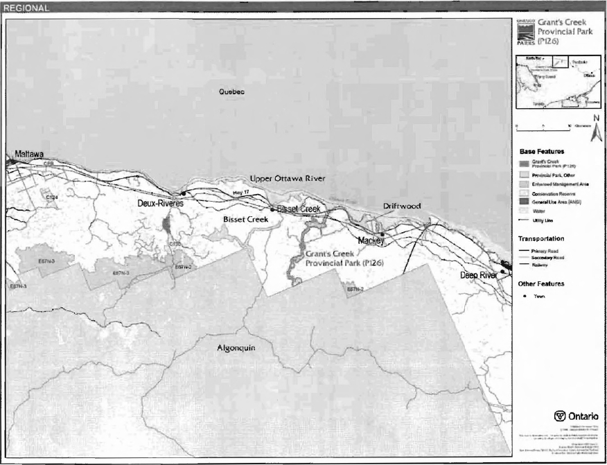
Grant’s Creek Provincial Park (P126) is situated between Bissett Creek and Mackey, and is approximately 10 kilometres, more or less, from either location (Figure 1). This 1,444 hectare park is within Head and Maria townships, and Ecodistrict SE-10 (Figure 2). The park was established to protect the provincial significant Grant’s Creek Marsh and to provide an important ecological link between Upper Ottawa River and Algonquin provincial parks.
Grant’s Creek Provincial Park was regulated as a provincial park in June 2006 (O. Reg. 331/06). This provincial park was identified through Ontario’s Living Legacy Land Use Strategy (OMNR 1999) and is classified as a waterway park. The purpose of the waterway designation is to protect outstanding recreational water routes and to provide high quality recreational and educational opportunities (OMNR 1992).
1.1 Objectives
Grant’s Creek Provincial Park will be managed consistent with the four objectives for provincial parks:
Protection: To protect provincially significant elements of the natural and cultural landscapes of Ontario.
Recreation: To provide provincial park outdoor recreation opportunities ranging from highintensity day-use to low-intensity wilderness experiences.
Heritage Appreciation: To provide opportunities for exploration and appreciation of the outdoor natural and cultural heritage of Ontario.
Tourism: To provide Ontario’s residents and out-of-province visitors with opportunities to discover and experience the distinctive regions of the Province.
2.0 Management context
The purpose of this Interim Management Statement (IMS) is to provide direction to ensure the custodial management of park resources. Future park planning may be undertaken as required to provide direction on significant decisions regarding resource stewardship, development, operations and permitted uses.
Park management will follow direction from:
- Provincial Parks Act (1990) and regulations
- Ontario Provincial Parks Planning and Management Policies (OMNR 1992)
- Ontario’s Living Legacy Land Use Strategy and policy clarifications (OMNR 2000), amendments, and related direction
- Crown Land Use Policy Atlas (OMNR 2004a).
In addressing custodial management obligations to protect park values and ensure public health and safety, Ontario Parks will ensure that policy and Environmental Assessment Act (1990) requirements are implemented.
Figure 1: Regional Context

Enlarge Figure 1: Regional Context
Figure 2: Park Boundary
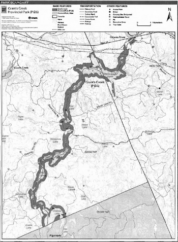
Enlarge Figure 2: Park Boundary
2.1 Environmental assessment
As a part of the Ontario Ministry of Natural Resources (MNR), Ontario Parks is a public sector agency which is subject to the Environmental Assessment Act. Park management will be carried out in accordance with legislation, policies, and guidelines that are required under A Class Environmental Assessment for Provincial Parks and Conservation Reserves (OMNR 2005).
3.0 Park features and values
The park boundary follows the natural watercourse of Grant’s Creek from Chateau Lake, which straddles the boundary of Algonquin and Grant’s Creek provincial parks, to the southern boundary of Upper Ottawa River Provincial Park at Highway 17. The boundary is set back, on average, 200 metres from the water’s edge and encompasses Grant’s Creek Marsh and several small lakes, including Puffball, Tigger, Pooh, Spencers, and Logslide lakes. The park boundary also includes the waters, creek bed, lakebeds, and Crown islands of the watercourse.
3.1 Geological features
Grant’s Creek Provincial Park is within the Opeongo Domain of the Algonquin Terrane of the Central Gneiss Belt, in the northeastern part of the Proterozoic Grenville Province. The bedrock is predominantly clastic supracrustal rocks, including migmatitic, medium grained biotite-K feldspar quartz-plagioclase gneiss, and thickly bedded, coarse-grained biotite-quartz-plagioclase gneiss, both of which are derived from impure sandstone (Frey and Duba, 2001).
The felsic and mafic gneisses are typical representations of clastic metasedimentary supracrustal components of the Opeongo Domain in the Algonquin Terrane, making the bedrock features of the park regionally significant. The park’s surficial till and glaciofluvial outwash deposits are from the Late Wisconsinan Stage of the Quaternary Era and are locally significant.
3.2 Biological features
The park protects an important ecological link between Algonquin Provincial Park and the Ottawa River. The park includes a series of small lakes and a large, provincially significant marsh. Some of the lakes are cold water trout lakes (Korol 2002).
Mature, pine-dominated conifer forests with a scattering of mostly-intolerant hardwoods flank the waterway. Almost 300 vascular plant species have been recorded in the park to date, and, 11 forest ecosite types1 eight forest understorey vegetation types, and 29 non-forested ecosystems were identified in 2002 by Korol.
Localized, but severe, impacts along all-terrain vehicle (ATV) trails and at campsites occur within the park, especially at water access points; however, most of the plant communities are in excellent condition despite these impacts. Twelve species of herpetiles, 87 species of birds, and at least 13 species of mammals were identified in the park (Korol 2002).
3.3 Cultural setting
A cultural resources inventory for Grant’s Creek Provincial Park has not been completed, but limited information was gathered by Marzinotto during the recreation inventory in 2002. The Grant’s Creek area of the Ottawa Valley was a historical occupation, travel, and trapping area for Algonquin First Nations, and later, it was an important logging region. Throughout the history of forestry use in the region, Grant’s Creek and a number of other creeks, including Mackey Creek, Bissett Creek, and Deux Rivieres Creek were important transportation routes and access points.
Any future planning will be within the context of a provincial framework, A Topical Organization of Ontario History (OMNR 1974). In addition, updates and discussions with First Nations and other agencies and stakeholders may be carried out to identify cultural heritage values and features within the park and their significance. This information may be used to develop management guidelines to conserve and protect representative archaeological and historical values and features, or to provide direction for further research.
3.4 Recreation
Resources in the park attract a variety of recreational uses, including backcountry canoeing, hunting, fishing, and natural appreciation and exploration. The creek’s scenic features include a small waterfall and a natural waterslide (Korol 2002). Due to the extensive road and trail network from previous uses, snowmobiles and ATVs travel through the area. Future management planning will review all uses, including snowmobile and ATV use, to ensure that park features and values are protected, and to assess the potential for these uses to conflict with other uses.
4.0 Aboriginal uses
Grant’s Creek Provincial Park lies within the Williams Treaties of 1923.
First Nations have expressed interest in and have shared knowledge of the park and surrounding area. Aboriginal communities have used the area for hunting, trapping, fishing, gathering and travel. These uses may continue, subject to public safety, conservation and other considerations.
Any communications and cooperation between Aboriginal communities and the MNR for planning and operations purposes will be done without prejudice to any future discussions or negotiations between the government of Ontario and Aboriginal communities.
5.0 Stewardship policies
The removal, damage or defacing of Crown properties, natural objects, relics, and artefacts is not permitted in provincial parks (Provincial Parks Act).
Non-native species will not be deliberately introduced into the park. Where non-native species are already established and threaten park values (i.e., has become invasive), a strategy to control the species may be developed (OMNR 1992).
5.1 Terrestrial ecosystems
The protection of provincially significant, special or representative life and earth science features will be a high priority for Grant’s Creek Provincial Park. Management of the area will allow natural processes to continue to shape the ecology of the park’s aquatic and terrestrial environments wherever possible. Monitoring and additional inventories will be encouraged. This may include a focussed assessment of plants, fish and or wildlife.
5.1.1 Harvesting
Commercial forest operations are not permitted within the park (OMNR 1992).
The harvest of non-timber forest products such as club moss, Canada yew, etc., will not be permitted within the park (OMNR 1992).
Existing authorized wild rice harvesting may continue. New operations will not be permitted.
There are no fuelwood cutting permits currently issued for the park. New permits will not be issued (OMNR 2000).
5.1.2 Insects and disease
Insects and diseases may be managed where the aesthetic, cultural, or natural values of the park are threatened. Control measures will follow guidelines established by the Ontario Ministry of the Environment (MOE) and MNR. Whenever possible, biological control measures will be given preference over the use of chemicals (OMNR 1992).
5.1.3 Fire
Grant’s Creek Provincial Park is located within the Great Lakes-St. Lawrence Fire Management Zone. In accordance with existing provincial park policy and the Forest Fire Management Strategy for Ontario, forest fire protection will be carried out in the park as on surrounding lands (OMNR 2004b). Whenever feasible, MNR's Forest Fire Management program will use techniques that minimize damage to the landscape, such as limiting the use of heavy equipment or limiting the number of trees felled during response efforts (OMNR 2004b).
5.1.4 Wildlife management
Grant’s Creek Provincial Park is located within Wildlife Management Unit 48. The removal or harassment of non-game animals is not permitted (Provincial Parks Act).
Hunting
Sport hunting is permitted to continue. Considerations of safety and conservation and representation (e.g., the designation of nature reserve zones), which may have an effect on the extent of hunting may be made through future management planning, which would include public and Aboriginal consultation (OMNR 2000).
The Fish and Wildlife Conservation Act (1997) and the Migratory Birds Convention Act (1994) govern hunting within the park. The Ontario Hunting Regulations Summary contains regulations specific to this area. The harvest of bullfrogs or snapping turtles is illegal in provincial parks.
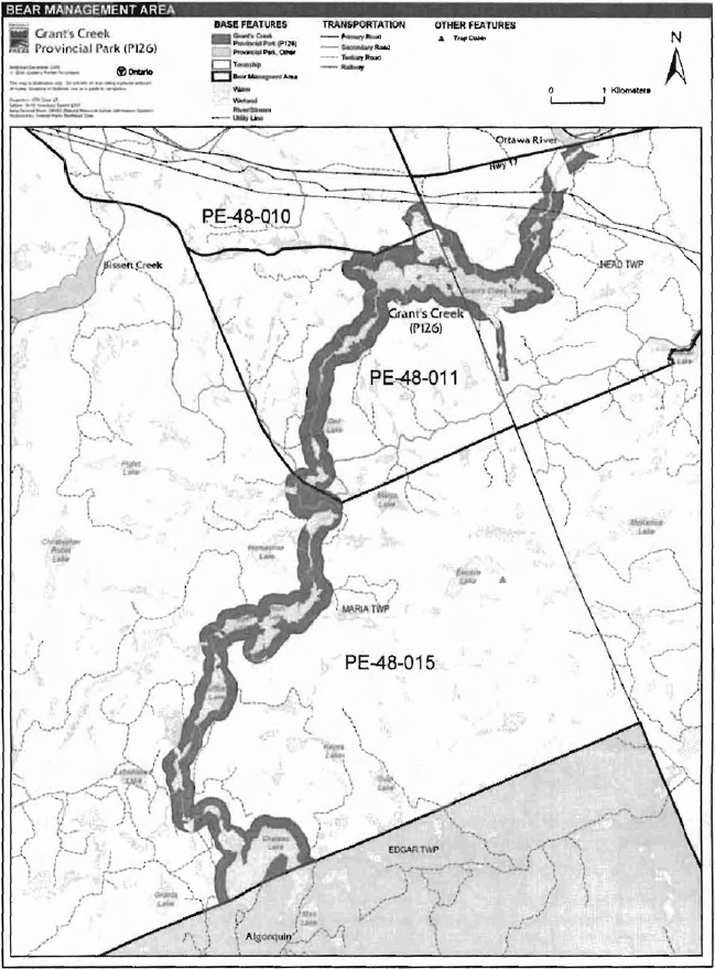
Bear management areas
Grant’s Creek Provincial Park includes portions of three bear management areas (BMA): PE-48-010, PE-48-011, and PE-48-015 (Figure 3).
Existing commercial bear hunting operations are permitted to continue. This activity may be subject to conditions identified during future management planning (e.g., the designation of nature reserve zones). New BMA licences will not be permitted (OMNR 2000; 2003).
Trapping
The park includes portions of two trapline areas: PEM30 and PEM29 (Figure 4). A trap cabin associated with PEM30 is located within the park, on Tigger Lake.
Figure 3: Bear Management Areas

Enlarge Figure 3: Bear Management Areas
Figure 4: Trapline Areas
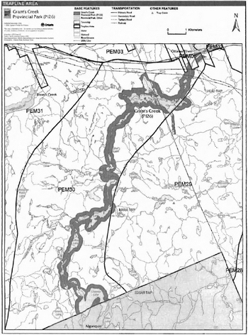
Enlarge Figure 4: Trapline Areas
Existing commercial fur harvesting operations may continue where the activity has been licensed or permitted since January 1, 1992. New operations, including trap cabins and trails, will not be permitted (OMNR 2000; 2003). Transfers of active trap line licenses are permitted, subject to a review of potential impacts and the normal transfer or renewal conditions that apply.2
5.1.5 Adjacent land
Forestry
The land adjacent to the park is within the Ottawa Valley Forest Management Unit (MU) #780. This MU is currently managed by Ottawa Valley Forest Inc. The management plan is in effect from 2006 to 2026 and will be reviewed in 2011 (OMNR 2006).
Provincial parks
Four provincial parks are located near Grant’s Creek Provincial Park: Algonquin, Driftwood, Upper Ottawa River, and Bissett Creek provincial parks.
Algonquin Provincial Park (P1915): Algonquin became Ontario’s first provincial park in 1893. The park, which abuts the boundary of Grant’s Creek Provincial Park, is situated in an area of rolling uplands and bedrock outcrops, and contains sand and gravel that are of glacial origin. At 772, 300 hectares, this biologically diverse park protects more than 1,000 plant species and more than 200 breeding vertebrates. The park contains numerous historical, archaeological, recreational, and scenic features and values.
Driftwood Provincial Park (P403): Regulated as a provincial park in 1963, Driftwood contains glacial remnants such as sand and gravel, diabase dikes, ice-push ridges and a well-pronounced esker. The park landscape has been more recently shaped by the opening of a hydroelectric dam, which caused farmland and a small lake to be submerged, and by a fire in the southern portion of the park in 1975. This park is located on the Ottawa River across the valley from the well know canoe route on the Dumaine River in Quebec.
Upper Ottawa River Provincial Park (P131): The park protects the portion of the Ottawa River that extends south from Parkman Township to the Ontario Hydro Dam in Rolfton (a ghost town). The park contains many recreational, historical, and scenic values, and protects wetlands and upland white pine stands situated along this corridor.
Bissett Creek Provincial Park (P125): This park contains the Waterloo Lake Uplands Area of Natural and Scientific Interest (ANSI) and, like Grant’s Creek Provincial Park, it protects an ecological link from the Ottawa River to Algonquin Provincial Park. The park landscape ranges from a bedrock-controlled landscape dominated by young, intolerant coniferous and mixed upland forests in the western side, to a rugged waterway containing waterfalls and large boulders in the southern portion. This park offers a variety of recreational opportunities, including a canoe route from Algonquin Provincial Park to the Ottawa River.
Conservation Reserves
The conservation reserve (CR) network complements the provincial park system by protecting representative natural areas and special landscapes. Two CRs are located near Grant’s Creek Provincial Park: Greenbough Esker CR and Boom Creek Old Growth Forest CR.
Greenbough Esker Conservation Reserve (C130): The Greenbough Esker is a large, intact earth and life science feature. The CR boundary was formerly the Core Protection Zone of a larger ANSI. The remainder of the ANSI has been redesignated as the Greenbough Esker ANSI General Use Area (G435). This CR contains mature, undisturbed upland pine forests growing on an esker landform, as well peatlands which have developed in glacially-influenced areas of restricted drainage. The peatlands sustain unique vegetation types and uncommon to rare species (e.g., provincially rare White Fringed Orchid).
Boom Creek Old Growth Forest Conservation Reserve (C124): The Boom Creek Old Growth Forest is a rare natural feature in the Ottawa Valley area. Over half of this CR contains red and white pine stands aged 150 to 160 years, and the remainder contains stands aged 120 to 130 years. The CR is bordered by Rankin Creek on the east side and Boom Creek on the west side; these are both locally significant brook trout streams.
Enhanced management areas
Two portions of the Algonquin Provincial Park Headwaters Enhanced Management Area (EMA) are located near to Grant’s Creek Provincial Park.
Algonquin Provincial Park Headwaters-Pembroke Enhanced Management Area (E67n-2): Divided into two sections, this EMA was established to protect the headwaters of the abutting Algonquin Provincial Park. These areas support a variety of recreational activities and also contain high value timber resources.
Algonquin Provincial Park Headwaters-North Bay Enhanced Management Area (E67n-3): Divided into three sections, this EMA was established to protect the headwaters of Algonquin Provincial Park, which it abuts. Like E67n-2, this EMA contains high value timber resources and a variety of recreational landscapes. The entire area is unorganized.
General use areas
One general use area, the Multiple Natural Resource Use General Use Area, surrounds the park. Another, the Greenbough Esker ANSI General Use Area, is located near to Grant’s Creek Provincial Park.
Multiple Natural Resource Use General Use Area (G396): This 614,179 hectare management area covers a large portion of Eastern Ontario. Resource management in this general use area is directed towards multiple use management.
Greenbough Esker ANSI General Use Area (G435): The Greenbough Esker is a large, intact earth and life science feature. The General Use Area boundary was formerly the Resource Management Zone of a larger ANSI. The remainder of the previous ANSI has been redesignated as the Greenbough Esker Conservation Reserve (C130). The central and southern portions of this general use area contain mature, undisturbed upland pine forests growing on an esker landform. Peatlands supporting unique vegetation types and uncommon to rare plant species have developed in glacially-influenced areas of restricted drainage.
5.1.6 Land disposition
New land disposition for the private use of individuals or corporations will not be permitted (OMNR 1992; 2000).
Land Use Permits, Licenses of Occupation, and Unauthorized Occupations
Three recreation camp land use permits (LUP) are located within the park.
Existing authorized LUPs may be eligible for enhanced tenure but not the purchase of land. Recreational camp LUPs cannot be changed to commercial LUPs unless this is supported during a review as part of park management planning. Enhanced tenure is defined as a possible extension of the term of the LUP for up to 10 years or upgrade in tenure (i.e. LUP to lease) (OMNR 2000a).
Enhanced tenure for an LUP is not guaranteed. Requests for enhanced tenure or to transfer LUPs will be reviewed based upon the following criteria:
- Continued compliance with the conditions of the LUPs
- Current land disposition policies for LUPs
- Consistency with park objectives to sustain values - no effects on heritage values and/or conflict with other uses
- Consistency with Aboriginal land claim negotiations or protocol agreements
- All rents, taxes, fees, rates, or charges are paid and in good standing.
An extension in the term of tenure for an existing LUP does not convey a commitment to provide for a change in the type or the standard of existing access to the private recreation camp.
There are no licenses of occupation and no known unauthorized occupations in Grant’s Creek Provincial Park.
Leases
There is a Water Power Lease Agreement (WPL), WPL 102 held by Ontario Power Generation within the park. WPL 102 extends from the Ottawa River upstream on Grant’s Creek as far as Lot 36 Concession 16 in Head Twp to an elevation of 47 metres above mean sea level in the park.
Patent land
Grant’s Creek Provincial Park is mostly surrounded by Crown Land, except in Head Township, where patent land abuts and bisects the park. Private land is not included within the park boundary and, as such, park policy does not apply to these areas.
Boat caches
There are no authorized boat caches within Grant’s Creek Provincial Park. Boats are not permitted to be left unattended in the park without written permission from the superintendent under the authority of the Provincial Parks Act.
5.1.7 Access and crossings
Access
Grant’s Creek Provincial Park is accessible by land, water, and air.
There are several unmanaged road access points in the park. Most of these are associated with former logging roads and trails. Major access points are located in the north, directly off of Highway 17, and in the south, on the northwest side of Chateau Lake. Other informal access points and parking areas are located throughout the park, including those at Grant’s Creek Marsh, Menet Lake Road, Puffball Lake, and the southeast side of Chateau Lake.
The park can be accessed from various locations on the Ottawa River, including from Driftwood Provincial Park. Access to the park is also possible by a canoe route originating to the east of Grant’s Creek and passing through Eeyore Lake. The park may be accessed by portage from this route. At the southern end of the park, there are two boat launches on Chateau Lake.
Access to the park by floatplane is limited to Pooh and Chateau lakes.
Roads
A major access point to Grant’s Creek Provincial Park is located off of Highway 17, slightly to the west of Grant’s Creek. This location provides access to the canoe route. Another tertiary road branching from Highway 17 leads to an access point at Grant’s Creek Marsh.
Bissett Creek Road, which turns into Menet Lake Road, is an active logging road that can provide access to the park from the west side. On the east side, Menet Lake Road can be taken from the hamlet of Stonecliffe towards the park. This road crosses Grant’s Creek at Grant’s Creek Bridge within the park. Access to the creek is not possible at the bridge due to the shallow and rocky bottom of creek at this point.
Chateau Lake can be accessed by at least two routes. Menet Lake Road continues south, past Keyes Lake, on the western side of Grant’s Creek. This road, which travels over an unstable bridge, leads to an established campsite on the eastern shore of Chateau Lake. The alternate route to the Chateau Lake is via Bissett Creek Road on the western side of the park. A gravel road, which branches off of Bissett Creek Road, travels past Lafreniere Lake and Puffball Lake, eventually leading to the north shore of Chateau Lake.
Other, less used old logging roads and trails in the area provide additional access to Grant’s Creek Provincial Park. While not suitable for most vehicles, these roads may provide unauthorised access by ATVs and snowmobiles. The use these roads will be assessed and a strategy prepared to managed unplanned use.
Where existing forest and/or tertiary access roads are essential for continued access beyond the park for forest management, access to in-holdings (e.g., LUPs) or recreational purposes, and alternative road access does not exist, or road relocation is not feasible, existing roads will continue to be available for access. Continued use will include maintenance and may include upgrades (OMNR 2004a). Ontario Parks is not responsible for the maintenance or upgrade of any roads within the park boundary.
Any proposed development, maintenance or upgrading of existing roads must meet all Environmental Assessment Act requirements.
Utility Corridors
A Trans Canada natural gas pipeline crosses Grant’s Creek in Head Township. This high pressure pipeline is on a 30 metre easement. The easement is excluded from the park boundary.
An hydro line corridor crosses the park in Head Township. This corridor is included in the park boundary. This corridor is managed through a province-wide LUP issued to Hydro One.
Maintenance of the utility lines must adhere to the regulations set out under the relevant acts, such as the Environmental Assessment Act, the Canadian Environmental Protection Act (1999), and the Pesticides Act (1990). Maintenance activities will not impact negatively on the features and values being protected within the park additions.
All public utilities (e.g., gas pipelines, transmission lines, communications towers) must avoid park lands wherever possible. New utility corridor crossings may be necessary to maintain essential public services (OMNR 2004a).
Any future utility corridors proposed through the park, where park lands are unavoidable, will be reviewed on a case-by-case basis. Protection of park features and values will be a priority and all requirements of the Environmental Assessment Act will be met.
Recreational trails
Canoe Routes and Portages: The Grant’s Creek canoe route is no longer regularly maintained. The four-day backcountry route is considered to be challenging, rugged, and recommended for experienced wilderness travellers only (Marzinotto 2002). The nature of Grant’s Creek requires numerous portages between rapids and chutes. There are least 12 unmaintained portages in Grant’s Creek Provincial Park, some are still marked by old MNR portage signs.
Hiking Trails: There are no designated hiking trails within in Grant’s Creek Provincial Park.
Snowmobile Trails: Two authorized snowmobile trails pass through Grant’s Creek Provincial Park. The Ontario Federation of Snowmobile Clubs (OFSC) trunk trail 'A' follows the Trans Canada Pipeline corridor. Also, OFSC Club Trail 195, travels along Menet Lake Road, which passes through the park, crossing Grant’s Creek Bridge (OFSC 2007). An unnamed snowmobile trail occurs on a gravel road outside the northern boundary of the park (Marzinotto 2002).
All-Terrain Vehicle Trails: There are no authorized ATV trails within the park boundary; however, there is some existing unauthorized ATV use on forest and tertiary access roads within the park (e.g. Menet Lake Road).Existing use of these roads to access LUPs is permitted continue unless this use threatens park values. ATV use may be authorized on old forest access and tertiary roads; this use will be reviewed during future park management planning. Off-trail ATV use is not permitted (OMNR 2000).
5.2 Aquatic ecosystems
Sustaining quality water resources is integral to the protection of park and adjacent land values. The MOE enforces applicable legislation and regulations for water quality.
5.2.1 Water management
There are no hydro developments, water control structures, or diversions within the park. Ontario Power Generation has a water power lease (WPL 102) for flooding rights of the Ottawa River which extend into Grant’s Creek Provincial Park as far as Logslide Lake.
New commercial hydroelectric developments will not be permitted (OMNR 2000).
Fisheries Management
Grant’s Creek Provincial Park mainly supports fishing for lake and brook trout. Splake have been stocked in the past, and smallmouth and largemouth bass have been introduced into some lake trout lakes, which has caused a decline in natural trout populations (Marzinotto 2002).Fisheries management will complement the maintenance and enhancement of native, self-sustaining fish populations (OMNR 1992).
Sport Fishing
Sport fishing is permitted within the park. This activity is governed by legislation and regulations in the Fish and Wildlife Conservation Act and the Fisheries Act (1985). The Recreational Fishing Regulations Summary contains details on the applicable regulations for this area.
Commercial baitfish harvesting
Portions of two baitfish harvesting areas are within Grant’s Creek Provincial Park: PE0107 and PE0108 (Figure 5).
Existing commercial baitfish harvesting may continue where the activity has been licensed or permitted since January 1, 1992.This activity may be subject to conditions identified through future park management planning or fisheries management plans. New baitfish licenses will not be permitted (OMNR 2000; 2003).
Figure 5: Baitfish Harvesting Areas
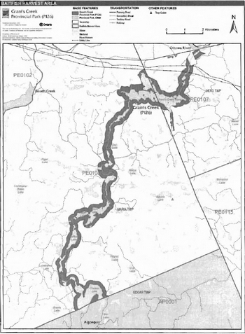
Enlarge Figure 5: Baitfish Harvesting Areas
Fish stocking
The stocking of native fish species may be considered through park management planning, with full public and Aboriginal consultation. Non-native fish species will not be deliberately introduced into park waters (OMNR 1992).
6.0 Operations policies
6.1 Recreation management
Future planning, with full public and Aboriginal consultation, will review direction on motorized and non-motorized recreation uses.
6.1.1 Motorized recreation
Motorboats
The use of motorboats is permitted to continue, unless park values are being threatened (OMNR 2004a).
Aircraft
Aircraft landings may be permitted within this waterway park (OMNR 2004a). All aircraft landings are subject to regulation and valid aircraft landing permits issued by the park superintendent under the authority of the Provincial Parks Act.
Snowmobiles
Two authorized OFSC snowmobile trails pass through Grant’s Creek Provincial Park and one unnamed trail travels along the northern boundary. Snowmobile use on established routes for access to private land in-holdings, LUPs, and recreational ice fishing may continue unless park values are threatened. Off-trail snowmobile use is not permitted within the park. Proposals for new snowmobile trails may be considered though future planning with public and Aboriginal consultation (OMNR 2000).
All-terrain vehicles
There are no authorized ATV trails within the park boundary. The existing use afforest and tertiary access roads to access LUPs is permitted continue unless this use threatens park values. ATV use may be permitted on old forest access and tertiary roads. Off-road use of all terrain vehicles will not be permitted within the park. Proposals for new trails may only be considered through future planning with public and Aboriginal consultation (OMNR 2000).
6.1.2 Non-motorized recreation
Camping
There are no managed campsites in Grant’s Creek Provincial Park. There are four unmanaged, established campsites (three are on Chateau Lake) in the park, as well as several identified potential campsites (Marzinotto 2002).
Ontario Parks may assess the condition of existing campsites and will maintain, rehabilitate, or close sites as required. If there is an identified need, new campsites may be considered (OMNR 2004a). Infrastructure will be permitted in order to protect park features and values in response to use, environmental deterioration and environmental protection requirements. Any proposed development in the park must fulfill the requirements of the Environmental Assessment Act.
Hiking
There are no authorized hiking trails within the boundaries of this provincial park. If there is an identified need, the development of new hiking trails may be considered. Trail infrastructure to protect park values and features will be permitted. Any proposed development within the park is subject to Environmental Assessment Act requirements.
Canoeing/kayaking
The canoe routes and portages within Grant’s Creek Provincial Park are currently unmanaged. Existing uses may continue, unless park values are threatened (OMNR 2004a). Infrastructure to protect park features and values may be permitted and developed in response to use, environmental deterioration and environmental protection requirements.
6.1.3 Emerging recreational uses
There are emerging recreational uses for which there is limited or no policy to deal with their management (e.g., adventure racing and geocaching). The park superintendent will use legislation, policy, and guidelines which are in place to manage emerging uses.
6.2 Development
There are two existing boat launches on Chateau Lake and other access points in the park. Existing boat launches and access points will be permitted to continue unless this use threatens park values. Infrastructure to protect park features and values may be permitted and developed in response to use, environmental deterioration, and environmental protection requirements. Any proposed development within the park is subject to the Environmental Assessment Act.
6.3 Commercial tourism
New commercial tourism facilities may be considered where they would be consistent with park policy (OMNR 2004a). Any development must meet the requirements of the Environmental Assessment Act. Existing authorized tourism facilities may continue subject to management prescriptions determined through management planning. Existing tourism facilities (e.g., LUPs, leases) may be eligible for enhanced tenure, and decisions will be made in management planning.
7.0 Cultural resources
The Grant’s Creek area of the Ottawa Valley was a historical occupation, travel, and trapping area for Algonquin First Nations, and later, it was an important logging region. An assessment of the cultural resources specific to the park has not yet been completed. The management of any cultural values within this park will be directed toward protection and heritage appreciation (OMNR 1992).
8.0 Heritage education
Literature and other supporting information may be developed to describe the park in the context of Ontario’s provincial park system. Boundary limits, significant heritage features and permitted uses of the may be included in park literature.
Prospective park visitors may be informed about the sensitivity and significance of park values through park literature.
9.0 Research
Scientific research by qualified individuals which contributes to the knowledge of natural or cultural history, or to environmental or recreational management, may be encouraged in the park. Ontario Parks will encourage institutions, such as universities, to undertake research projects.
All research programs will require the approval of Ontario Parks and are subject to park policy and other applicable legislation. Any materials removed from the park will remain the property of Ontario Parks.
Approved research activities and facilities will be compatible with the park’s protection objective. Any site which is affected by research will be rehabilitated as closely as possible to its original state. environmental assessment act requirements will apply.
10.0 References
Canadian Environmental Protection Act, 1999.
Environmental Assessment Act, 1990. Fish and Wildlife Conservation Act, 1997. Fisheries Act, 1985.
Frey, E., and D. Duba, 2001. P126 Grant’s Creek Provincial Park Earth Science Checksheet.
Korol, J.B., 2002. A Detailed Life Science Inventory of Grant’s Creek Provincial Park.
Marzinotto, E., 2002. Grant’s Creek Provincial Park (P126) Recreation Resource Inventory Report.
Ontario Federation of Snowmobile Clubs, 2007. Ontario Federation of Snowmobile Clubs: Trail Guide. Online. Accessed January 9, 2007. http://www.ofsc.on.ca/TraiiGuide/TraiiGuide.asp
Ontario Ministry of Natural Resources, 1974. A Topical Organization of Ontario History. Historic Sites Branch Division of Parks.
Ontario Ministry of Natural Resources, 1992. Ontario Provincial Parks Planning and Management Policies. 1992 Update.
Ontario Ministry of Natural Resources, 1999. Ontario’s Living Legacy Land Use Strategy. July 1999. Queen’s Printer for Ontario.
Ontario Ministry of Natural Resources, 2000. Ontario’s Living Legacy Land Use Strategy (Policy Clarification).
Ontario Ministry of Natural Resources (OMNR), 2003. Directions for Commercial Resource Use Activities in Provincial Parks and Conservation Reserves. 5 pp.
Ontario Ministry of Natural Resources, 2004a. Crown Land Use Policy Atlas.
Ontario Ministry of Natural Resources (OMNR), 2004b. Forest Fire Management Strategy for Ontario.
Ontario Ministry of Natural Resources (OMNR), 2005. A Class Environmental Assessment for Provincial Parks and Conservation Reserves.
Ontario Ministry of Natural Resources, 2006. List of Forest Management Units (MU) in Ontario (2006-2007). Online. Accessed January 8, 2007. http://ontariosforests.mnr.gov.on.ca/spectrasitesNiewers/showArticle.cfm?id=C74F77D4-68C7-41A6-8D96FB6079073782&method=DISPLAYFULLNOBARNOTITLE_R&ObjectiD=C74F77D4-68C7-41A6-8D96FB6079073782&1ang=FR&Iang=EN&Iang=FR&Iang=EN (link no longer active)
Pesticides Act, 1990.
Provincial Parks Act, 1990.
Taylor, K.C., R.W. Arnup, B.G. Merchant, W.J. Parton, and J. Nieppola, 2000. A Field Guide to Forest Ecosystems of Northeastern Ontario (2nd ed.). Queen’s Printer for Ontario.
Appendix A: Background information
| Name | Grant’s Creek Provincial Park (P126) |
|---|---|
| Classification | Waterway |
| Ecoregion/Ecodistrict | 5E / 5E-10 |
| OMNR Administration Region/District | Northeast Region - Pembroke District |
| Total Area (ha) | 1,444 |
| Regulation Date and Number | June 2006 (O. Reg. 331/06) |
Representation
Earth science:
Grant’s Creek Provincial Park is a waterway linking Algonquin Provincial Park to the Ottawa River. The dominant rock types are felsic and mafic gneisses derived from clastic metasedimentary protolith of the Opeongo Domain, Algonquin Terrane, in the northeastern part of the Central Gneiss Belt of the Proterozoic Grenville Province (Frey and Duba 2001).
The Grenville Province is the product of thrusting and imbrication of the crust to the northwest as it collided with a continental landmass to the southeast. The Grenville Orogeny, circa 1140 to 1070 million years ago, culminated more than 500 million years of crustal evolution. The eroded roots of the products of these events are displayed in the complexly metamorphosed and deformed rocks of the region (Frey and Duba 2001).
The Algonquin Terrane in one of four lithotectonic terranes of the Central Gneiss Belt. Within the Algonquin Terrane, the Opeongo Domain is the largest of twelve structural domains. This geological environment is part of the modern organization of the complex products of the mid Proterozoic Grenville orogenic events. As such, its representation in Grant’s Creek Provincial Park contributes to the conservation of the Grenville continental accretion theme (Frey and Duba 2001).
Life science:
The Grant’s Creek corridor provides protection for the park’s resources and the ecological link between Algonquin Provincial Park and the Ottawa River. At least 294 species of vascular plants were found in the study area. The forests support 10 species of gymnosperms and 10 species of deciduous trees. Eastern White and Red pine were the most frequently observed conifers and Jack Pine and Eastern White Cedar were uncommon. The most common deciduous trees were White Birch and Red Maple. White Elm and Yellow Birch were seldom observed. Of the 38 species of deciduous shrubs Beaked Hazel and Sweet Gale were the most abundant. Ericaceous shrubs were well represented with 14 species. Ferns (17 species), other pteridophytes (7 species), grasses (18 species), dicotolydenous (112 species) and monocotyledenous (65 species) herbs complete the species list. Only 21 species (7.1% of the park’s flora) of non-native plants were identified and they were concentrated in disturbed areas such as ATV trails, portages, campsites and hunt camps (Korol 2002).
Eleven forest Ecosite Types were identified at 38 locations in the park. Over half of the forest Ecosite Types identified in the study area were Red or Eastern White pine dominated. Intolerant hardwood and mixedwood stands were found at four locations and nine sites had lowland conifer or hardwood stands. Essentially all of the forests along the park corridor are dominated by conifers. Eastern White and Red pine were the most prevalent upland species, but White Spruce and Balsam Fir were common sub-components. Significant patches of Black Spruce and Tamarack, with scattered Eastern White Cedar, occupied some shoreline areas. The only hardwood dominated stands were not much larger than one ha and were found in widely separated locations (Korol 2002).
At least 13 species of mammals were recorded in Grant’s Creek Provincial Park in 2001. Red Squirrels and Eastern Chipmunks were the most commonly seen species, but active Beaver lodges and dams were present throughout the park. In addition, two family groups of River Otters found in the park, and another family was seen just outside of the park boundary near Pooh Lake. It was somewhat surprising that no Snowshoe Hares or their sign were observed. Wolf tracks were observed just outside of the park boundary on the trail to Grant’s Creek marsh in early May (Korol 2002).
Cultural resources:
The Algonquin First Nations have traditionally occupied portions of the lands within the Ottawa River watershed and traveled through the surrounding territory as a hunting and gathering society. The portage trails in the Grant’s Creek area are reported to have been used as local trapping routes by First Nations (Marzinotto 2002).
Throughout the rise and fall of the forest industry in the region, Grant’s Creek and a number of other creeks, including Mackey Creek, Bissett Creek and Deux Rivieres Creek, played crucial roles as transportation routes and as access points to large amounts of forested land. Many improvements were made to the streams to facilitate transportation of timber. Wagon roads were also established alongside the creeks and were in use as early as the 1840's. The roads became even busier when the Canadian Pacific Railway line was completed along the Ottawa River after 1882. Many of these roads are still in use today, including Bissett Creek Road (Marzinotto 2002).
Although a cultural heritage inventory has not yet been carried out for the Grant’s Creek area, several potential cultural heritage sites and features were encountered during the 2001 field season. The portage trails in the Grant’s Creek area might be of potential cultural heritage interest. They were used as local trapping routes by First Nations up until the middle of the twentieth century (Marzinotto 2002).
Recreation:
The main recreational activities in Grant’s Creek Provincial Park include canoeing, fishing, hunting, and snowmobiling. Unauthorized ATV use likely occurs within the park on existing tertiary access roads and trails (Marzinotto 2002).
Two canoe routes and associated portages are associated with the park. The routes are not maintained but can still provide a challenging, rustic backcountry experience. These routes should only be undertaken by those familiar with wilderness travel and camping (Marzinotto 2002).
Inventories
| Survey Level | Earth Science | Life Science | Cultural | Recreational |
|---|---|---|---|---|
| Reconnaissance | Duba and Frey 2001 | Korol 2002 | Required | Marzinotto 2002 |
1 Ecosites are mappable, management-oriented groupings of vegetation on specific ranges of soil conditions. Ecosites have relatively uniform parent material, soils, hydrology and vegetation structure, and composition (Taylor, Arnup, Merchant, Parton, and Nieppola 2000).
2 Transfers include situations where a license is surrendered with a request that it be immediately reissued to another individual or organization that is assuming an existing operation. Trap cabins are considered part of a trapline and would be transferred with the trapline for the purposes of trapping. If a trapline license is revoked or surrendered, all portions of the registered line within the park will be rescinded from the legal description of the trap line (OMNR 2003).