Greenwater Provincial Park Management Plan
This document provides policy direction for the protection, development and management of Greenwater Provincial Park and its resources.
Minister’s approval statement
Greenwater Provincial Park, located in the Great Clay Belt of Northeastern Ontario, is an area of high natural and recreational value. Established in 1957, Greenwater has served as a popular recreation area by providing a variety of opportunities to both tourists and local residents. The park serves as a stopover campground for visitors taking the Polar Bear Express to Moosonee on James Bay and as a destination campground for those who enjoy the tranquil setting for which the park is known.
While ensuring the provision for year-round recreational activities, the master plan emphasizes the protection of significant natural features. At this time, would like to extend my gratitude for the valuable commentary provided by individuals and groups during the public participation program and look forward to your continued interest inthe planning of other provincial parks throughout Ontario.
In accordance with The Provincial Parks Act, Sections 1d and 7a, I am pleased to approve Greenwater Provincial Park Master Plan as the official policy for the future development and management of the park.
Honourable James A.C. Auld
Minister
January, 1979
Planning participants
Team members
A. Currie - Park Planner, Northern Regional Office
B. Hutchinson - Field Services Supervisor, Cochrane District
L. Ladoucer - Park Superintendent, Greenwater Provincial Park, Cochrane District
R. Macnaughton - Unit Forester Cochrane District
R. W. Stewart - Biologist, Cochrane District
B. Therriault - Outdoor Recreation Supervisor, Cochrane District
Consultants
Diane Culm - Biologist, Cochrane District
Ed Frey - Geologist, Northern Regional Office
G. O’Reilly - Visitor Services Programmer, Northern Regional Office
Master plan highlights
Greenwater Provincial Park, located 34 km northwest of Cochrane has been open to the public for the past 21 years and has served as a popular recreation area for local and Ontario residents.
Established in 1957 and classified as a natural environment park, Greenwater… named for the peculiar green colour of one of its 26 lakes…provides good opportunities for brook trout, rainbow trout, lake trout, northern pike, yellow pickerel and yellow perch fishing.
All types of outboard motors are not presently allowed on park lakes except electric motors of 5 hp or less. This latter exemption is still pending regulation.
Although hunting has been prohibited in the park, hunters use the park as a stopover or for hunting adjacent to the park.
The 5,350 ha park is centered on a long 61 m high ridge. This ridge, or esker, was once the bed of a river which flowed within glacial ice less than 10,000 years ago during the melting period.
Greenwater presently has 104 campsites and a potential for double the capacity as demands increase and funds permit. The recent addition of the Deception Creek area to the park has increased opportunities for canoeing, wildlife viewing, as well as the other facilities offered i.e. scenic hiking, interpretive trails and outdoor education programs.
Maintenance of the environmental integrity of the park is a major objective of this plan and is reflected in the zoning, policies and management strategies outlined in this plan.
Preface
Glaciers and man have been two of the most significant forces to shape the landscape of Northeastern Ontario.
Glacial and postglacial events, approximately 8,000 to 10,000 years ago, left prominent esker systems, clay till, and lacustrine clay plains throughout the north.
In more recent times, particularly within the last 75 years, man entered the Northeastern Ontario scene as a settler and entrepreneur. These pioneers came from many parts of Canada and the world; many to stay, some to die and others to leave, leaving behind only an imprint of their occupation.
Today, in Northern Ontario, it is not uncommon to find a provincial park occupying and reserving an area of glacial disposition and/or an area of past human occupation. Greenwater Provincial Park is a case where a park includes an esker system and remnants of past agricultural and logging activities.
1.0 Introduction
The Greenwater Provincial Park Master Plan describes the biophysical, cultural and recreational resources and identifies the goal and objectives for the park. It also establishes comprehensive policies for the planning, preservation, development and management of park resources. Resource management plans for the parkare also included in this plan.
2.0 Regional setting
2.1 Location
Greenwater Provincial Park (49°11’N - 49°15’N and 81°15’W - 81°20’W) is located in the Cochrane District (Figure 1) of the Northern Administrative Region, Ministry of Natural Resources and the Northeastern Planning Region as defined by the Strategic Land Use Plan for Northeastern Ontario (S.L.U.P., 1977). The park is located in the Great Clay Belt of Northern Ontario, 33.8 km northwest of Cochrane and 802 km northwest of Toronto. Greenwater Provincial Park encompasses an area of 5,350 ha.
2.2 Regional climate
Greenwater is situated in the Northern Clay Belt climatic region (Chapman and Thomas, 1968). This climatic region has been identified as modified continental. The Great Lakes and Hudson Bay modify weather conditions slightly. In summer, warm humid air masses from the south alternate with cooler drier air from the north to produce periods of clear, dry weather followed by warmer humid weather. In winter, there are often days of snow squalls and high winds alternating with clear, cold, dry weather. On the average, summer days in this region receive one hour more of daylight than those of Southern Ontario.
Enlarge Figure 1: Northern administrative and northeastern planning regions (PDF)
2.3 Regional physiography
The southern half of the Northern Administrative Region is underlain by the Precambrian igneous rock of the Canadian Shield, and the northern half by the Paleozoic sedimentary bedrock of the Hudson Bay Lowlands. Greenwater Provincial Park is located on the northern edge of the shield in the Great Clay Belt. The clay belt itself demarks an area once covered by pro-glacial Lake Barlow-Ojibway. Unconsolidated Quaternary deposits can be found overlying much of the region including most of the park area. These deposits range from clay to till cover. Prominent in a few locations throughout the north are glaciofluvial features. One such feature, an esker complex, bisects the parks.
2.4 Regional vegetation
The major forest region found in the Ministry of Natural Resources Northern Administrative Region, including Greenwater Provincial Park, is the Boreal Forest (Rowe, 1972). Black spruce, tamarack, aspen, jack pine and white birch are the dominant species within this area. Black spruce is the predominant species in the low-lying areas. Mixed-wood stands of aspen, white birch, balsam fir and white spruce occupy glacial ridges and associated uplands. Jack pine predominates on the sand plains.
2.5 Crown land recreation
The role of Crown land in the north cannot be under-estimated. It is from Crown land that most of the north’s timber resources come and it is on Crown land that 47.1 percent of all outdoor recreation occasions take place (Crown Land Recreation Study, 1977). In the Northern Administrative Region, there are 29,986,310 ha of Crown land which constitutes approximately 82 percent of the land base. In the Cochrane District there are 3,107,574 ha of Crown land and approximately 29,940 ha are park reserves and provincial parks.
2.6 Population
In 1976, the total population of the Cochrane Census Division was 96,825 (1976, Census of Canada). The Ministry of Natural Resources Northern Region has a slow growing economy and few non-resource oriented manufacturing industries. The major sources of employment in the region are forest and forest-based industries, mining and mine-based activities, tourism and agriculture. Commercial fishing and trapping provide employment on a seasonal or part-time basis. Secondary industries dependent on the mining and forestry industries include transportation and construction. Government services also play an important role in the economic base of the region. Major population centres in the vicinity of Greenwater include Cochrane, population 4,862; Iroquois Falls, 6,726; Smooth Rock Falls, 2,433; Kapuskasing, 12,694; and Timmins, 42,981. Approximately 1,300 people occupy the rural areas within 100 km of the park (Figure 2).
Enlarge Figure 2: Regional setting (PDF)
2.7 Access
Most of the small and some of the major transportation arteries in the North have been aligned according to major mineral deposits and forest production areas. The major traffic artery leading into the region is Highway 11 running north from Toronto through North Bay to Cochrane then west to Thunder Bay. Secondary traffic arteries include Highways 129 and 144 leading north from Thessalon and Sudbury respectively to Highway 101 linking Chapleau and Timmins to Highway 11.
Highway 66 and Highway 101 link the region to Quebec highways which in turn lead to most northern and southern population centres within that province. Highway 807 runs north from Smooth Rock Falls 65 km to Fraserdale.
The main access to Greenwater Provincial Park is Highway 11 west from Cochrane for 19.3 km and then 14.5 km north along the Clute and Calder township boundary road. A new highway is presently under construction from Timmins which will intersect Highway 11 at Driftwood (24 km west of Cochrane). This highway will provide easier access to the park from Timmins and should result in a substantial increase in the utilization of Greenwater Provincial Park. The nearest railway station is located in Cochrane. The Canadian National Railway runs from Quebec City through LaSarre and Cochrane west to Nakina. The Ontario Northland runs north from Toronto through Cochrane to Moosonee. Ontario Northland bus services also link Cochrane with most Northern and Southern Ontario centres. A small municipal airstrip is located 3.2 km northeast of Cochrane.
3.0 Market analysis
3.1 Regional
The trends in recreation demand for the Northern Administrative Region, reveal a changing picture (Crown Land Recreation Study, 1978). Several factors which are contributing to these changes are:
- lower fertility rates;
- migration from Ontario;
- changes in the attractivity of Ontario as a tourist destination;
- increases in winter vacation trips; and
- increased energy costs.
Recent survey data
Another factor which appears to be affecting tourism in the north is the decrease in the average length of vacation trips taken by car. Since the Northern Region requires a long trip from the main market sources, the effects have been noticeable. Further trends have occurred particularly in the purpose of the vacation trips and types of experiences sought. In the latter case, it seems that vacationers are interested in spending time at vacation spots. The north has an additional factor which may affect tourism in the north is the age/sex factor. One could assume that older persons tend to travel south for recreation rather than north. If this is true, the older segment of the future population may adversely affect the growth of tourism in the Northern Region.
Given all of the above trends, tourism still remains a major industry in the north. The Northern Administrative Region offers a large number of both public and private campgrounds, private tourist establishments and vast amounts of Crown land. Approximately 327 commercial tourist establishments are located in the region. Most are located adjacent to major traffic arteries. Twenty licenced fly-in tourist outfitters operate within the region. For the touring public, 37 commercial tent and trailer campgrounds are available.
Currently, 17 provincial parks are situated in the Northern Administrative Region providing approximately 1,200 developed campsites. Five of these parks are situated along Highway 11. In addition to provincial parks there are 8 park reserves with an unestimated total development potential. As well, 123 access points and 46 designated canoe routes provide additional recreation opportunities in the Region.
Private recreation facilities also contribute to the total recreation supply. There are approximately 3,595 private cottages and 673 hunt and fish camps in the Northern Region.
3.2 Local
Thirteen municipal and private campgrounds are located within a 100 km radius of Greenwater Provincial Park (Table 1). Drury Park, a municipal park located in the Town of Cochrane, has a substantial influence on the visitation at Greenwater. Both Greenwater and Drury cater to the stopover tourist interested in taking the Polar Bear Express to Moosonee. However, a transient camper preference for Drury exists because of its proximity to train facilities. The actual influence on Greenwater of the remaining 12 camping areas is unknown (Figure 3).
Table 1: Municipal and private campgrounds within 100 km of Greenwater Provincial Park
| Highway Access | Name and Location | Area (Hectares) | Number of Campsites |
|---|---|---|---|
| #11 | Drury Park, Cochrane | 30 | 140 |
| #11 | Terry’s Campgrounds, 11.2 km south of Cochrane | 220 | 20 |
| #574 | Birchill Park Cabins | 4 | 10 |
| #101 | Perry Lake Hunt and Fish Lodge | 32 | 10 |
| #11 | Pull in Campground, 1.6 km south of Matheson | 11 | 5 |
| #101 | Reid Lake Campgrounds, 24 km west of Matheson | 2 | 25 |
| #11 | Vi-Mar Campgrounds, 3.2 km north of Matheson | 1 | 7 |
| #581 | Chalet Brunelle, 4.8 km north of Moonbeam 20 | 20 | 20 |
| #11 | Highway Beach, 8 km north of Porquis Junction | 121 | 90 |
| #629 | All Seasons Park, 8 km north of Highway 629 | 32 | 56 |
| #576 | Horseshoe Lake Park, Kamiskotia | 8 | 15 |
| #655 | Bigwater Park,Timmins | N/A | N/A |
| #11 | Pender’s Campground, Tunis | 1 | 10 |
Two provincial parks are located within a 100 km radius of Greenwater Provincial Park: Kettle Lakes and Remi Lake provincial parks. Both are classed as recreation parks according to the 1978 Classification of Provincial Parks in Ontario. Kettle Lakes is located on Highway 67, 40 km east of Timmins and 100 km from Greenwater. The main role of the park is to provide intensive recreation facilities for the local population of Timmins. Remi Lake Provincial Park is located 12.9 km north of Moonbeam off Highway 11. Remi Lake has assumed the role of serving local Kapuskasing residents. Greenwater is located midway between Kettle Lakes and Remi Lake provincial parks. Neither park attracts substantial visitors away from Greenwater. If anything, visitors from both Timmins and Kapuskasing are attracted to Greenwater because of its natural conditions and less intensive development.
Pierre-Montreuil Park Reserve is located 100 km northeast of Greenwater Provincial Park. This 16,211 ha reserve has a moderate potential for camping and water-based activities such as fishing, swimming and canoe-tripping. If Pierre-Montreuil becomes established as a provincial park, it may attract part of Greenwater’s local and nonlocal destination camper market.
Within a 100 km radius of Greenwater are situated six official access points: Sangster Lake, Deception Creek, Mistango Lake, Redsucker River, Departure Lake and Gardiner Ferry. These provide access to water and are, in many instances, heavily used by local fishermen and canoeists. All official access points are maintained by the Ministry of Natural Resources.
Enlarge figure 3: Local setting (PDF)
Two designated provincial canoe routes exist within the district: the Abitibi and Mattagami rivers. Both offer good backcountry travel opportunities.
Fishing opportunities in the Cochrane District are available for brook, lake and rainbow trout, yellow pickerel, sturgeon, whitefish and northern pike. Fly-in fishing is rated good to excellent.
Moose and bear hunting in the District is fair. The success of fly-in moose hunters is higher than in the more accessible areas. Waterfowl hunting is considered poor to fair in the area. Ruffed, spruce and occasionally sharp-tailed grouse are also available. A commercial pheasant farm approximately 6.4 km west of Cochrane offers fall hunting.
3.3 Other recreational opportunities
The Town of Cochrane offers a variety of interpretive opportunities for visitors. The Cochrane Railway and Pioneer museum and the Ministry of Natural Resources’ Interpretive Car, located east of the Ontario Northland Station, contain exhibits on trapping, mining, railways, wildfire, forestry, agriculture, human history of the frontier and an audio-visual program about Cochrane and the Moosonee area. The Cochrane plywood mill (Cochrane Enterprises Limited) offers guided tours of their plant.
The Polar Bear Express operated by Ontario Northland Railway runs from Cochrane to Moosonee. It is a popular train excursion with summer visitors. Points of interest along the route include: the Island Falls and Otter Rapids dams, native and historic settlements, the Abitibi and Moose rivers, the “Upside Down” bridge, and Moosonee and Moose Factory.
Many historical sites are found in the Cochrane area and some are marked with appropriate plaques (e.g. commemorating the founding of Cochrane, marking the 49th parallel, indicating the Niven survey line cut 70 years ago).
Iroquois Falls, located 48 km southeast of Cochrane, offers the Iroquois Falls Railway Museum and the Abitibi Paper Company’s Iroquois Falls Mill. The company has guided tours of a logging operation which show clear-cut and regenerated stands, forestry harvesting techniques and equipment, and the mill operation.
In the Timmins area, there are two mining tours offered: Pamour Mines and Texas Gulf concentrator and refineries.
3.4 Recreational needs
In 1973, the Northeastern Ontario Recreation Survey was conducted to determine the recreational needs of the 489,795 residents of Northeastern Ontario. To conduct this survey, Northeastern Ontario was subdivided into 40 service areas. From each service area, a representative sample was drawn. Most of the Cochrane District was included in service area 5. The survey found that 52.7 percent of the total participation in Northeastern Ontario was accounted for by outdoor recreation activities (i.e. hunting, fishing, bathing and picnicking). Structured recreation activities (i.e. team sports, cultural activities) accounted for 47.5 percent. It was found that 67.2 percent of outdoor recreation activities occurred on a daily basis instead of an extended period of one or more nights. Table 2 identifies the percent participation for Northeastern Ontario, the Northern Region, and the Cochrane service area for each of the 8 outdoor activities examined by the survey.
The most popular activities in Northeastern Ontario are nature appreciation, swimming, picnicking and fishing. Hunting, fishing, snowmobiling and bathing are the preferred activities in the Cochrane Service area. The high participation in hunting and fishing in the Cochrane area may reflect the high use of Crown land. Table 3 presents the percentage outdoor recreation participation by land use type for Northeastern Ontario, the Northern Region and the Cochrane service area.
While private land appears to accommodate the highest proportion of participation in Northeastern Ontario and the Northern Region (42.4 and 38.5 percent respectively), it is Crown land which receives the most use in the Cochrane area. Other service areas adjacent to Cochrane display a similar high use of Crown land.
The United States is the major non-resident tourist market for Northeastern Ontario (U.S. Auto Exit Study, 1969) followed by residents of Quebec. In 1969, it was estimated that 14 percent of all American visits to Ontario, greater than one day in duration, were destined for Northeastern Ontario. Of all the possible Ontario destination points, Northeastern Ontario ranked second. These American visitors identified hunting, fishing, camping and tenting as the reasons for their visit.
Table 2: Percent participation in outdoor recreation activities by regions and area
| Outdoor recreational activity | Northeastern Ontario | Northern Region | Cochrane Service Area |
|---|---|---|---|
| Hunting | 6.8 | 10.8 | 18.5 |
| Fishing | 14.3 | 17.0 | 17.7 |
| Boating | 9.7 | 10.8 | 7.3 |
| Nature Appreciation | 24.8 | 13.7 | 9.8 |
| Picnicking | 16.1 | 19.7 | 17.5 |
| Skiing | 3.4 | 2.4 | 0.7 |
| Snowmobiling | 7.7 | 10.2 | 17.1 |
| Bathing | 17.2 | 15.4 | 11.4 |
| Total | 100.0 | 100.0 | 100.0 |
Source: Northeastern Ontario Recreation Participation Survey, 1975
Table 3: Percent outdoor recreation participation by land use type
| Land use type | Northeastern Ontario | Northern Region | Cochrane Service Area |
|---|---|---|---|
| Private Land | 42.4 | 38.5 | 24.6 |
| Crown Land | 35.5 | 33.7 | 40.1 |
| Provincial Parks | 6.4 | 7.8 | 7.3 |
| Other Parks | 5.4 | 5.5 | - |
| Access Points | 10.2 | 14.6 | 28.0 |
| Total | 99.9 | 100.1 | 100.1 |
Source: Northeastern Ontario Recreation Participation Survey, 1975
4.0 The park
The Ontario provincial parks system, of which Greenwater Provincial Park is a component, makes a very distinctive contribution to recreation and conservation in Ontario.
The goal and objectives of the provincial parks system are:
Goals
To provide a variety of outdoor recreation opportunities, and to preserve provincially significant natural, cultural and recreation environments in a system of provincial parks.
Objectives
Protection: To protect provincially significant elements of the natural and cultural landscape of Ontario.
Recreation: To provide provincial park outdoor recreation opportunities ranging from high intensity day-use to low intensity wilderness experiences.
Heritage appreciation: To provide opportunities for exploration and appreciation of the outdoor natural and cultural heritage. of Ontario.
Tourism: To facilitate travel by residents of and visitors to Ontario who are discovering and experiencing the distinctive regions of the Province.
Greenwater Provincial Park contributes to all 4 objectives by providing a variety of recreational opportunities to both the local and non-local resident. Further, the boundaries of Greenwater provide. protection to a number of locally and regionally significant plant communities and geomorphological features. Greenwater also contributes to the heritage appreciation objective through interpretation of historical farming remnants located in the southwest corner of the park.
4.1 Legal status
Greenwater was officially designated a provincial park in 1957 by Ontario Regulation 144. It is classified as a Natural Environment Park under the 1967 Ontario Provincial Parks Classification System. In 1977, an additional 910 ha of the Deception Creek area was added to the east boundary of the park.
4.2 Park boundaries
The park encompasses parts of four townships. It includes the southeast section of Colquhoun Township, Concession -VI, Lots 1 to 8; the southwest corner of Leitch Township, Concession to IV, Lots 24 to 28 and Concession V and VI, Lots 27 and 28; the northeast corner of Calder Township, Concession XII, Lots 1 to 8; and the northwest corner of Clute Township, Concession XII, Lots 24 to 28. The total park area is 5,350 ha of which 210 ha is water.
4.3 Mineral exploration
Prior to the establishment of Greenwater, no prospecting or claims staking occurred within the park. A recent airborne geophysical survey by Shell Canada has delineated some anomalies adjacent to and within Greenwater Provincial Park. These anomalies appear to indicate the presence of base metal sulphide. The bedrock mineral potential of the Greenwater area is rated as medium to high.
An unsuccessful search for aggregate sources was conducted in 1955 in the southeast corner of the park. The esker within Greenwater has good gravel deposits, the remainder of the park is considered to have low aggregate potential.
4.4 Land disposition
No leased land or unauthorized buildings exist within the present park boundaries with the exception of one summer cottage under Land Use Permit, located on Deception Creek (Lot 24, Concession XII, Clute Township). Two patents exist which cover the southern section of the hydro lines belonging to Ontario Hydro (76.6 ha) and Abitibi Paper Company (5.7 ha). These lines parallel each other. The remainder of the power lines are established on Crown land covered by licence of occupation. Both lines predate the establishment of Greenwater Provincial Park. Greenwater abuts private land on most of its south boundary. The north, east and west boundaries abut Crown land.
4.5 Forest management
Before 1960, logging by clear-cut and selective-cut methods had a major influence affecting 50 to 60 percent of the park. An active silvicultural program has taken place in the park for the last 20 years. This program included tending of plantations which were planted in cut over, burned and agriculturally cleared land. Active timber harvesting is taking place immediately adjacent to the north, northwest and northeast boundaries of the park.
4.6 Wildlife management
Park policy has been to allow hunting north of the development zone (campgrounds and day-use areas) or one mile from any travelled road within the park. This was permitted because there was little or no conflict with the park users. Presently, 181 user-days are consumed annually by hunters.
A small captive flock of Giant Canada and Blue geese are located on Lloyd and Pike lakes each summer.
One registered trapline (PE-85) includes the park area. This trapline has been operated since 1936 with beaver as the major fur bearing species. An aerial survey of the trapline in 1972 located 64 live beaver colonies. From this count, an annual quota of 96 beaver was established.
4.7 Fish management
Most of the brook, lake and rainbow trout fishing is provided by a “put and delayed take” program. Native species include northern pike, yellow pickerel, yellow perch and a small population of native brook trout in Deception Creek.
Park and Green lakes were reclaimed to eliminate undesirable fish species in 1969 and 1975 respectively. A voluntary creel census was conducted on all of the park lakes from May 31 to December 31, 1976.
The park lakes have been a part of the Fish and Wildlife management program of the Cochrane District since 1950. At present, lake, brook and rainbow trout are planted on a rotational basis in seven of the park lakes. In 1976, two small experimental plantings of northern pike were introduced into Upton and Lucky lakes. The fisheries management plan for Greenwater emphasizes a put and delayed take trout fishery for several reasons: 1) the absence of natural trout spawning areas, 2) the good water qualities which are available for maintaining trout populations, 3) the lack of trout lakes in the Cochrane District, and 4) the need to provide a good recreational sports fishery for local residents and tourists.
4.8 Visitor services
A seasonal park naturalist conducts an interpretive program for the park visitors. Activities include young people’s programs, wilderness cook-out demonstrations and evening programs. The six hiking trails and one self-guiding interpretive trail (Green Trail) are popular with the park visitors. During 1977, 985 personal contacts and 2,456 facility contacts were made.
4.9 Park development
Table 4 provides a complete inventory of the current park facilities (Figure 4). Existing and potential developable areas are presented in Appendix 6.
Camping
There are three organized campgrounds in the park: Blue-Lloyd Lake (37 sites), Park Lake (40 sites), and Blue Lake East (30 sites). These areas offer such facilities as vault toilets, chlorinated water systems, a central woodyard, fireplaces, picnic tables and a central garbage system. No interior campsites have been developed.
Day-use
The main day-use area is located at the south end of Green Lake and offers 1,115 m2 of wet and dry beach area, 11,520 m2 of picnic area, parking area for 106 cars, a diving raft, fireplace grills, two change houses and three sets of vault toilets.
There are 9 km of interior park roads. Six hiking trails (11.8 km) and one self-guiding trail (1.2 km) are available. There are no established snowmobile, cross-country skor snowshoe trails within the park. The access roads, the hydro corridor, and the developed trails; however, are frequently used for winter recreation activities. There is 5.5 km of good canoeing on Deception Creek. Most of the park lakes provide good canoeing potential.
Table 4: Present park facility inventory
| Facility | Area |
|---|---|
| Day-use beach (dry) | 558 m2 |
| Day-use beach (wet) | 558 m2 |
| Day-use beach - Picnic Area | 1.15 ha |
| Park Area (vehicles) | 106 |
| Campgrounds - Campsite Units | 107 |
| Utilities - Water Pressure System | 1 |
| Utilities - Water Lines | 4.8 km |
| Utilities - Trailer Filling Station | 1 |
| Utilities - Trailer Filling and Dumping Station | 1 |
| Utilities - Transmission Lines - overhead | 1.2 km |
| Utilities - Transmission Lines - underground | 0.4 km |
| Utilities - Centralized Garbage | 3 |
| Buildings - Entrance Control Booth | 1 |
| Buildings - Summer Staff Quarters | 1 |
| Buildings - Maintenance Building | 1 |
| Buildings - Change House | 2 |
| Buildings - Type 2 Vault Privy | 11 |
| Buildings - Type 2 Vault Privy (basin) | 1 |
| Buildings - Vault Privy (Centennial + 1) | 1 |
| Buildings - Pumphouse | 1 |
| Buildings - Shower-Laundromat Complex | 1 |
| Roads and Trails- Paved - two way | .96 km |
| Roads and Trails- Gravel - one way | 3.22 km |
| Roads and Trails - two way | 4.83 km |
| Trails - Interpretive (self guiding) | 1.2 km |
| Trails - Hiking | 11.8 km |
| Trails - Snowmobile | 12.87 km |
| Structures - Lookouts | 1 |
| Structures - Docks | 6 |
Enlarge figure 4: Park facilities (PDF)
4.10 Park capacity
With 107 campsites, Greenwater can provide an optimum carrying capacity of 13,135 camper-days based on a 60 percent occupancy rate and a 62-day season (July and August) (Table 5). Optimum capacity is defined as a level of use which is environmentally sound and which is normally less than the maximum level of use.
The park’s interior (i.e. Deception Creek and the esker system) has good potential for about 15 interior campsites with an annual capacity of 3,000 camper-days.
The existing intensive day-use facilities have an annual capacity of 19,065 user-days. Frequently, heavy use and overuse occur on weekends when large groups are admitted to the day-use area. With the present level of development, the day-use area can accommodate approximately 201 users at any one time (theoretical daily capacity) (Appendix 5).
Table 5: Carrying capacity of existing recreation facilities (1977)
| Facility type | Existing Development | User-Day Potential | User-Day Consumption | Surplus user-days |
|---|---|---|---|---|
| Campground | 107 campsites | 13,135 (July-August) |
13,318 (July-August) |
0 |
| Green Lake picnic area |
1.15 ha | 8,005 | 5,536 | + 3,469 |
| Green Lake day-use wet beach |
558 m2 | 8,005 | 5,536 | + 3,469 |
| Green Lake day-use dry beach |
558 m2 | 8,005 | 5,536 | + 3,469 |
| Access and Hiking Trails | 11.8 km | 6,000 | 4,112 | + 3,544 |
| Self-guiding Nature Trail (Green Trail) |
1.2 km | 6,000 | 4,112 | + 3,544 |
| Canoe Route (Deception Creek) | 5.5 km | 600 | 100 | + 500 |
The Deception Creek area offers 5.5 km of excellent canoeing. Park, Blue, Lloyd, Green and Bear lakes all have easy access for canoeing and fishing. These lakes have a capacity to provide 1,600 fishing days annually. All park lakes have an annual fishing capacity of 11,320 user-days. This capacity was calculated on the basis of creel census returns and field observations.
The 11.8 km of hiking trails in the park have a seasonal capacity of 6,000 user-days. This was calculated on the basis of interpretive statistics and estimates by park personnel.
4.11 Current recreation capacity
Camper-use characteristics
Both destination and stopover campers stay in Greenwater Provincial Park. A 1976 survey showed that 34 percent of the campers were stopover and 66 percent were destination. The average party size is 3.3 persons. The average length of stay has increased from 1.4 days in 1968 to 3.1 days in 1977 (Table 6). The high percentage of stopover campers, who stay only one or two nights, may be influenced by the schedule for the Polar Bear Express to Moosonee. Approximately 83 percent of the campers originate in Ontario, 11 percent in the United States and 6 percent in the other provinces.
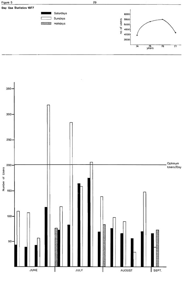
Percentage occupancy of the park’s campgrounds during July and August increased from 41 percent in 1967 to 62 percent in 1970 to a maximum of 81 percent in 1971 (Table 6). The occupancy rate decreased to 48 percent in 1976 when 30 new campsites were developed. If the present utilization trends continue, the campgrounds will reach optimum capacity by 1979-80 (60 percent capacity).
Park data sheets show that in 1977, 13,318 camper-days were consumed.
Table 6: User statistics record -Greenwater Provincial Park (for the period June/Sept.)
| Year | Number sites | Total Visitation*1 vehicles |
Total Visitation*1 visitors |
Day-Use*2 vehicles |
Day-Use*2 visitors |
Camping campers |
Camping camper days |
Camping |
Camping occupancy rate*3 |
|---|---|---|---|---|---|---|---|---|---|
| 1977 | 107 | 13,494 | 42,139 | 1,345 | 4,136 | 5,215 | 13,318 | 3.1 | 49% |
| 1976 | 107 | 13,414 | 49,607 | 1,490 | 5,313 | 5,347 | 12,760 | 2.3 | 48% |
| 1975 | 107 | 15,330 | 55,344 | 1,451 | 5,369 | 5,227 | 11,656 | 2.2 | 41% |
| 1974 | 80 | 6,103 | 21,477 | 1,088 | 3,699 | 5,026 | 10,932 | 2.2 | 52% |
| 1973 | 78 | 9,051 | 32,996 | 1,348 | 4,886 | 5,745 | 11,269 | 2.2 | 55% |
| 1972 | 50 | 7,296 | 28,278 | 759 | 2,581 | 4,564 | 9,346 | 2.1 | 47% |
| 1971 | 50 | 6,478 | 25,937 | 1,073 | 3,648 | 4,949 | 10,340 | 2.1 | 81% |
| 1970 | 52 | 5,177 | 22,862 | N/A | N/A | 4,138 | 8,658 | 2.1 | 62% |
| 1969 | 52 | 2,456 | 15,327 | N/A | N/A | 4,095 | 6,401 | 1.6 | 45% |
| 1968 | 51 | 4,620 | 20,465 | N/A | N/A | 3,034 | 4,324 | 1.4 | 41% |
| 1967 | 45 | 4,762 | 21,158 | N/A | N/A | 2,624 | 4,786 | 1.8 | 41% |
*1based on traffic count
*2based on permit sales
*3July August campsite occupancy rate, based on 60% optimum use × (5)
Day-use characteristics
After 16 years of operation (1961-1977), the statistics indicate a higher percentage of day-use visitors to the park than campers (based on traffic-counter estimates). If the present trend is projected, there w11 be an increase from 6,000 day-users in 1975 to 8,800 in 1980. A four year comparison (1974-1977) based on permit returns and day-use statistics for the 1977 park season is presented in Figure 5.
Summer recreation activities
Recreation canoeing is a popular summer activity in the park. Estimated seasonal use is 1,500 user-days. Fishing during the 1977 summer season resulted in the consumption of 2,300 user-days of fishing opportunities. In 1977 1,121 user-days were consumed by park visitors using the self-guiding interpretive trail. In the same year, 1,335 people hiked along the 11.8 km of trails.
Winter recreation activites
Snowmobiles are permitted on the main park roads. The number of visitors engaging in cross-country skiing and snowshoeing is relatively low (200 user days annually), while ice fishing activity is moderate to light (750 user-days annually). No parking facilities are provtded during the winter season.
Group visitors (Non-paying)
The park facilities were not used extensively for camping or day-use by organized groups. In 1977, 5 camping groups (229 campers) and 8 day-use groups (445 people) utilized the park facilities.
Seniour citizens (Non-paying)
In 1977, senior citizens utilized 98 user-days and 448 camper-days (1977 Park Statsties).
5.0 Biophysical resources
5.1 Climate
In general, the climate of the park area is marked by warm summers with long hours of daylight and cold winters with heavy snowfall. Mean monthly maximum and minimum temperatures are -12°C and -24°C for January and 24°C and 11°C for July respectively. Mean annual precipitation is 79 cm (Chapman and Thomas, 1968). The average rainfall is 54.0 cm. The maximum average accumulated snowfall is 91.4 cm and is reached by March. The prevailing winds are westerly. Freeze-up dates range from October 30 to November 24 (average November 14). Major leaf fall occurs during the second week of October (Harrison, 1973).
5.2 Geology and geomorphology
Early Precambrian (Archean) granitic plutonic rocks (more than 2.5 billion years old) with pegmatitic phases comprise the few documented bedrock outcrops in the park. Approximately 200 m2 of bedrock is exposed. The bedrock topography is unknown but its variability is suggested by the more than 50 m elevation difference between the outcrop surface in the southwestern part of the park and the bottom of Park Lake (Figure 6).
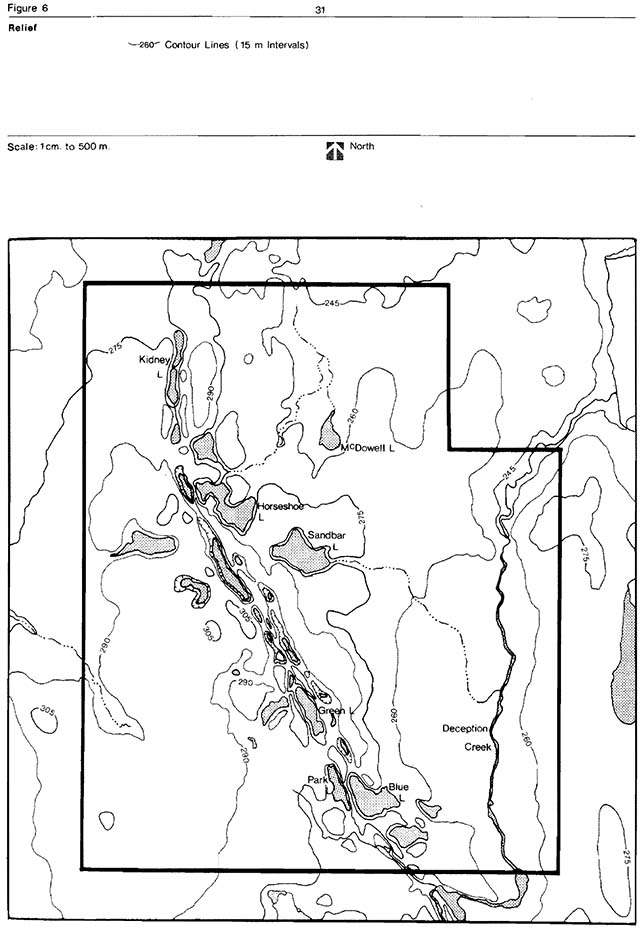
Enlarge figure 6: Regional setting (PDF)
The Precambrian erosion surface is buried by a variety of unconsolidated sediments deposited by Quaternary continental glaciers and their meltwaters. The most prominent landforms are the central esker and the numerous water-filled kettles that parallel its base. Observed lithologies and their stratigraphic relationships indicate that only Late Wisconsinan and Recent sediments are present in the park. The sediments record (1) the recession (about 9,200 years ago) of the last major continental glacier that covered central Canada, (2) a local readvance (about 8,200 years ago) and a recession (about 8,100 years ago) of the minor ice sheet (the Cochrane lobe, whose southern margin reached a point approximately 10 km north of Timmins), and (3) the recent filling of bogs, depressions, and stream channels with organic, colluvial and fluvial sediments (Figure 7).
The northward recession of the last Laurentide ice sheet flooded a vast area of northeastern Ontario and northwestern Quebec. The meltwaters formed Lake Barlow-Ojibway approximately bounded to the south, in its later stages, by the present St. Lawrence River - Hudson Bay drainage divide and to the north by the front of the ice sheet. Numerous eskers were formed by subglacial streams depositing debris into the proglacial lake as the ice margin receded.
Glaciolacustrine varved clays and silts of Lake Barlow-Ojibway are commonly exposed in the park vicinity. Their presence within Greenwater Provincial Park has not yet been established.
Glaciofluvial sediments, that accumulated within and beyond the ice margin, form the esker and adjacent buried outwash deposits. They consist of stratified sand and gravel and are exposed on the eroded upper slope of the esker, the surface of the esker road, and in the small excavation adjacent to the park entrance road.
The Cochrane lobe overrode these deposits and landforms blanketing them with clay till, often more than 1 m thick. Cochrane till forms the present surface material of most of the park including segments of the esker crest. It is well exposed in the vertica1 wall of the excavation near the park entrance. The till’s surface of contact with the underlying glaciofluvial sand and gravel is also visible.
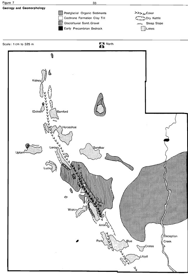
Enlarge figure 7: Geology and geomorphology (PDF)
The rapid melting of the Cochrane lobe formed shallow lakes on the land surface. Their sediments (fine sand and silt) overlie the Cochrane till in many of the topographically low areas and on the steep slopes of kettles and the esker. Colluvial sand and gravel, eroded from the slopes also contribute to the partial burial of Cochrane till in the depressions. In the park vicinity, the oldest radiocarbon date measured on wood found in peat overlying post-Cochrane lacustrine deposits is 6,380 ± 350 years ago. This provides a minimum date for the drainage of the post-Cochrane lakes and the beginning of bog formation.
The soils of the park are developed from parent materials transported by glaciation. A significant component is calcium carbonate derived from Paleozoic sediments in the James Bay Lowlands. Weak podzols have developed on the upland sands, gray luvisols on the calcareous upland clays, peaty. gleysols in the low areas and organic soils in the bogs.
5.3 Hydrology
Greenwater Provincial Park is contained within the 4MD1 and 4MD2 watershed units (Watershed Divisions Map 25WD Cochrane, 1974) which is part of the much larger Hudson Bay watershed system. Those lakes having perennial outlets drain eastward via Deception Creek (6 km of which lies within the park boundaries) into the Frederick House River, then northward into the Abitibi and Moose rivers and eventually into James and Hudson bays.
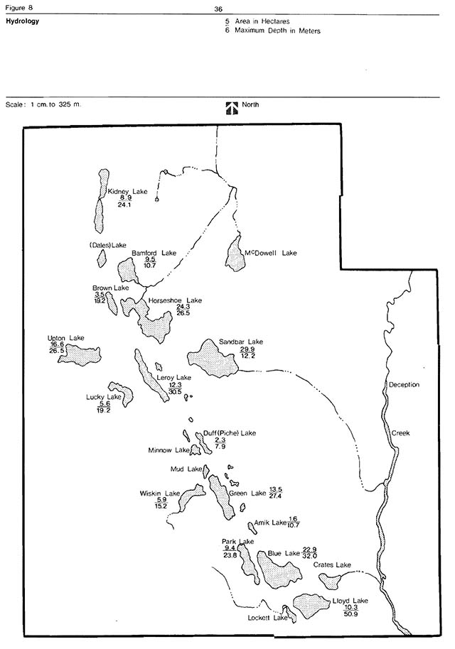
The park has twenty-six small lakes covering 200.7 ha and creek systems covering 24.2 ha (Figure 8). The lakes vary in area from 0.4 ha to 29.9 ha (Table 7). The remaining bodies of water consist of shallow pot holes and beaver ponds.
Both mesotrophic and oligotrophic lakes are present in the park. These lake types are classified according to the amount of nutrients present, the soil characteristics and the depth of the lakes. Park, Bamford, Crates, Lockett and McDowell lakes are examples of mesotrophic lakes with moderate amounts of dissolved nutrients and aquatic plant growth along the lake margins. Sandbar, Lloyd, Kidney, Blue, Leroy and Green lakes are representatives of oligotrophic lakes which are nutrient-poor and have little aquatic vegetation. The pH range of the park lakes is 7.0 to 8.5. Those lakes with pHs above 7.0 indicate the presence of calcareous (alkaline) materials (Table 7).
At present, Deception Creek has not been monitored or surveyed sufficiently to give a complete analysis of its hydrology.
5.4 Fisheries
In addition to the introduced trout species, there are natural populations of yellow perch in Horseshoe, Lucky, Upton, Sandbar and Brown lakes and northern pike in Horseshoe Lake (Table 8). Deception Creek contains natural populations of northern pike, white sucker, yellow pickerel, brook trout, yellow perch, lake whitefish and numerous minnow species. A more detailed inventory of fish species and aquatic invertebrates is recorded in the park’s Fisheries Management Plan.
Enlarge figure 8: Hydrology (PDF)
Table 7: Water Statistics of the Major Lakes in Greenwater Provincial Park
| Lake Names | Area (hectares) | Depth (metres) mean | Depth (metres) max | Secchi Disc - Diss. O2 (ppm - Reading taken at 1.5 meter level) | Secchi Disc- reading (metres) | Secchi Disc pH |
|---|---|---|---|---|---|---|
| Blue | 22.9 | 8.6 | 32.0 | 8.0 | 10.3 | 8.0 |
| Lloyd | 10.3 | 12.5 | 50.9 | 8.6 | 6.7 | 8.0 |
| Green | 13.5 | 11.2 | 27.4 | 8.0 | 7.8 | 8.5 |
| Park | 9.4 | 5.8 | 23.8 | 8.0 | 6.4 | 8.1 |
| Wiskin | 5.9 | 4.6 | 15.2 | 6.0 | 2.9 | 8.1 |
| Duff (Piche) | 2.3 | 3.8 | 7.9 | 7.0 | 6.3 | 8.2 |
| Kidney | 8.9 | 5.5 | 24.1 | 10.0 | 5.8 | 8.0 |
| Leroy | 12.3 | 9.5 | 30.5 | 11.0 | 5.6 | 7.0 |
| Horseshoe | 24.3 | 6.6 | 26.5 | 9.0 | 3.4 | 8.5 |
| Lucky | 5.6 | 4.9 | 19.2 | 9.0 | 2.6 | 7.0 |
| Upton | 16.6 | 5.4 | 26.5 | 10.0 | 2.9 | 7.5 |
| Sandbar | 29.9 | 3.9 | 12.2 | 8.0 | 3.4 | 7.0 |
| Brown | 3.5 | 5.3 | 19.2 | 8.0 | 4.4 | 7.0 |
| (Dales) | 2.4 | 4.1 | 16. 1 | N/A | N/A | N/A |
| Amik | 1.6 | 2.5 | 13.7 | N/A | N/A | N/A |
| Bamford | 9.6 | 1.6 | 10.7 | N/A | N/A | N/A |
N.B. The remaining 10 small lakes and pot holes have not been surveyed since they exhibit limited potential for stocking with salmonid species
Table 8: Fish species distribution in the surveyed lakes and Deception Creek within Greenwater Provincial Park
| Lake Name | Lake Trout | Rainbow Trout | Brook Trout | Northern Pike | Yellow Pickerel | Yellow Perch | White Sucker |
|---|---|---|---|---|---|---|---|
| Blue | S | N/A | N/A | N/A | N/A | N | N |
| Lloyd | S | N/A | N/A | N/A | N/A | N | N |
| Park | N/A | N/A | S | N/A | N/A | N/A | N |
| Green | N/A | N/A | S | N/A | N/A | N/A | N/A |
| Wiskin | S | N/A | S | N/A | N/A | N/A | N/A |
| Duff (Piche) | N/A | N/A | S | N/A | N/A | N/A | N/A |
| Kidney | N/A | N/A | S | N/A | N/A | N/A | N/A |
| Leroy | N/A | S | N/A | N/A | N/A | N/A | N |
| Upton | N/A | N/A | N/A | S | N/A | N | N/A |
| Lucky | N/A | N/A | N/A | S | N/A | N | N/A |
| Sandbar | N/A | N/A | N/A | N/A | N/A | N | N |
| Horseshoe | N/A | N/A | N/A | N | N/A | N | N |
| (Dales)* | N/A | N/A | N/A | N/A | N/A | N/A | N/A |
| Amik** | N/A | N/A | N/A | N/A | N/A | N/A | N/A |
| Brown | N/A | N/A | N/A | N/A | N/A | N | N/A |
| Bamford* | N/A | N/A | N/A | N/A | N/A | N/A | N/A |
| Deception Creek*** | N/A | N | N | N | N | N | N |
*contains only small fish species
**not known to support any fish species
***supports a natural population of lake whitefish and small fish species
5.5 Vegetation
Greenwater Provincial Park is located in the B.4 Northern Clay Section of the Boreal Forest Region (Rowe, 1972). Forest growth and species composition in this section are influenced by widespread surface deposits of water-worked tills and lacustrine materials, a nearly level topography and local climatic conditions.
Past clear-cut and high grading logging operations have affected 50 to 60 percent of the park’s vegetational cover. Frequent and extensive fires between 1900 and 1940 have influenced another 15 to 20 percent of the park’s vegetation. These areas have been designated as fire and logging regeneration forest complexes. The wetland thicket and rock outcrop complexes have also been subjected to various degrees of human disturbance. Four areas of the park which have remained in a relatively undisturbed state in recent times are a lowland black spruce forest complex, a bog complex (Figure 9).
The “Fire Regeneration Forest Complex” occupies a large area of the southwestern section and a portion of the northeastern and southeastern parts of the park. Four associations: pioneer blueberry- lichen barren, young birch regeneration, young aspen- birch regeneration and mature aspen regeneration forest associations have been identified. They represent typica1 post fire serai1 stages.
The “Logging Regeneration Forest Complex” occupies most of the northwestern section of the park and the area surrounding Deception Creek (Figure 9). These areas are in various stages of regeneration and include both lowland and upland sites.
The “Well and Thicket Complex” occupies low wet sites along the shores of the lakes and creeks which have been disturbed by beaver damming, past logging operations and/or seasonal flooding.
Enlarge figure 9: Vegetation (PDF)
The “Rock Outcrops” occurs in two areas in the southwest corner of the park and one at the Deception Creek Falls. The land adjacent to these outcrops has been disturbed by fire and agricultural land clearing operations. No unusual plant species were recorded.
The “Black Spruce Forest Complex” is located in the northeast corner of the park. It can be divided into three associations: a black spruce swamp forest, a cedar-black spruce swamp forest and a black spruce-balsam fir forest.
The black spruce swamp forest is the dominant association within the complex. It represents a typical boreal forest in the Northern Clay Belt Region. Within this community, three orchid species, which are considered rare to the clay belt, were recorded (i.e. yellow lady’s slipper, Hooder’s orchis and one-leaf rein-orchis). The seasonal association, the cedar-black spruce swamp forest, occupies small islands or pockets within the black spruce swamp forest. Two plants of biogeographical interest were found: white mandarin (a member of the lily family) and black ash. The black spruce-balsam fir forest association occupies low marginal sites where the black spruce swamp forest graded into a drier mixed-wood upland forest association.
The second vegetation complex, that remained relatively undisturbed is the “Bog Complex”. Four associations comprise this complex; an immature open floating bog mat, an infilled low shrub bog, a lagg zone of speckled alder-sedge-buckbean and a mature black spruce-tamarack treed bog.
The immature floating bog mat association is confined to several localized depressions (i.e. northwest of Wiskin Lake and southeast of Lloyd Lake). The association is characterized by a semi-floating sphagnum moss mat adjacent to open water. The second association is an infilled low shrub bog located southeast of Lloyd Lake. Here the veg tation consists of an outer ring of mature black spruce and the occasional tamarack surrounding a closed thicket of low ericaceous shrubs (i.e. leatherleaf, bog rosemary and swamp laurel). The speckled alder-sedge-buckbean association occupies specialized sites, termed lagg zones, within the bog complex. In these areas, a continuous flow or seepage of fresh water from surrounding higher ground provides a nutrient-rich habitat for the growth of marsh plants which do not normally survive in the harsh acidic bog environments. The mature black spruce-tamarack treed bog association occupies an extensive low-lying area east of Green Lake. The vegetation is characterized by an open stand of co-dominant black spruce and tamarack. Orchids considered rare and scarce to the clay belt region were recorded in this treed bog (i.e. yellow lady’s slipper, leafy white orchis, one-leaf rein-orchis, Hooker’s orchis, small round-leaved orchis and heartleaf twayblade).
A “Mature Mixechwood Upland Forest Complex” is located in the northwest corner of the park on gently sloping west facing sites north of Upton Lake. The complex has remained relative undisturbed for approximately 140 years. The dominant association is a mature mixedwood stand of white spruce-white birch-balsam poplar-black spruce complex. The ground flora contains mesic plant species typical of the clay belt (i.e. wild sarsaparilla, large-leaved aster, bunchberry, clintonia and dwarf raspberry).
The “Aquatia Complex” (Figure 9) is closely associated with the wetland thicket complex. It consists of emergent, floating and submerged vegetation growing in communities that integrate with each other. Four representative areas are located along the shores of Lockett, McDowell and Crates lakes and Deception Creek. A plant checklist for the park is found in Appendix 1.
5.6 Fauna
Mammals
Many fur-bearing marrmals inhabit the park area. These include beaver, muskrat, lynx, river otter, marten red fox, mink ermine, fisher and possibly least weasel.
Several timber wolves are known to frequent the park and surrounding area.
Moose and white-tailed deer are the only representatives of the ungulate family which inhabit the area. There are approximately 4 to 6 moose in the park. A small population of white-tailed deer are present in the park area. These deer are at the extreme northern limit of their species distribution. Bear have been sighted in the Park Lake and Blue Lake East campgrounds.
Trapping grids were used in five representative communities to sample the numbers and species of small mammals which inhabit these areas of the park. The results of this inventory, the fur return printouts of trapline PE-85, and the official sightings are presented in Appendix 2.
Birds
The avian community of the park is both diverse and numerous. Spring migration provides excellent bird watching opportunities. Approximately 161 different bird species (including migrants) have been sighted and recorded in the park’s bird checklist (Appendix 3).
Amphibians and reptiles
Amphibians which inhabit the park, include Jefferson salamander, spotted salamander, American toad, wood frog, leopard frog, spring peeper and mink frog.
The only reptile known to inhabit the park is the eastern garter snake.
6.0 Cultural resources
The agricultural history of the park area as it relates to farming in the Cochrane Clay Belt (1910-1945) will be documented during the 1978 park season. Very little archaeological data exists for Greenwater as compared to that recorded for the Cochrane District.
6.1 Prehistory
Cochrane District was first inhabited (approximately 5,000 years ago) by the Abitibi Narrows peoples along the Abitibi and Frederick House rivers. Later (2,000 years ago), the district was occupied by another river oriented culture, the Laurel peoples.
Since 800 A.D. the area has been occupied by Northern Algonkians. Algonkian sites, which date to 1,400 A.D., have been discovered in the vicinity of the park.
No archaeological survey has been conducted within the park’s boundaries, but the area could have been utilized on a seasonal basis by prehistoric peoples (J. Pollock, 1976).
6.2 History
In 1867, an inland Hudson Bay Company post was established at Newpost, north of Fraserdale on the Abitibi River. Indians who traded at the post had a large system of hunting territories in the vicinity of the Abitibi River which included the present park boundary.
Early settlement general (1869-1931)
The growth of government information concerning the development potential of the Great Clay Belt of the Moose River Basin, can be divided into two periods.
Initially there was a slow accurnmulation of knowledge of the area’s resources by the provincial and federal governments. The land (Rupert’s Land) was vested to the Hudson’s Bay Company until 1869 when it carne under the jurisdiction of the Dominion of Canada. For the next 20 years the area remained in Federal hands - terra incognita. Then in 1889 it was ceded to Ontario (The Ontario Boundary Act of 1889).
In the second period, 1889-1905, a flurry of surveys were conducted. Aspirations from these reports were varied, Since the majority of these papers had yielded optimistic results, a second revived interest and intensive exploration followed. The vast agricultural, mining, pulp and hydroelectric potential implied that a whole new growth area could be developed. Government involvement provided the stimulus, the proposed railroad to James Bay, the catalyst. What transpired, was the last major colonization attempt in Ontario’s history.
The railroad, the main link in the settlement’s growth, was built as far as New Liskeard in January, 1905 and Cochrane in 1909. The sale of lots preceeded, or was in conjunction with the spread of the railway. The basis for land development was the Public Lands Act. It provided for the sale of designated public lands at 50 cents per acre, provided certain terms were fulfilled. For example: during the first three years, the land was to be occupied six months a year a house of at least 16“ × 20” dimension; land cleared at the rate of 2 acres per year; etcetera. The exploitation of the lots for timber soon became an alarming problem. The government reacted by, reducing the lots from 160 acres to 80 appointment of homestead inspectors to oversee the land clearing and insuring the lots were suitable for agricultural purposes.
The expansion of the settlement in the Clay Belt was of remarkable proportions. In less than 30 years, 200 or anized townships were created. By 1931, their population reached 81,000 of which 48 percent were located on farms.
Land settlment in the southwestern section of Greenwater Provincial Park
The major settlement by families of Eastern European origin, occurred in the early 1930s and lasted for about a decade. Evidence of an earlier influx of settlers between 1913 and 1921 was possibly obliterated by the forest fires of 1910 and 1916.
Availability and market for pulpwood and sawlogsprovided incentive to the settlers to clear land. Portable sawmills were located on Park and Upton lakes, and a highway right-of-way was cut during the 1930s across the present southern boundary of Greenwater Provincial Park. The tentative proposal was a bonus for landholders and speculators. However, the political climate changed as well as the road location.
By 1936, about 2,000 acres were under application for settlement. Of that amount, only 5 percent was cleared.
A combination of factors contributed to the gradual abandonment of the land:
- Withdrawal of the highway corridor;
- The recruitment of able-bodied men for World War (some never returned);
- The misleading concepts of the north, combined with a few lean years, caused many disenchanted settlers to leave;
- Many landholders sold or extracted the timber, having no inclinations towards agriculture;
- The depression posed many financial constraints that limited development;
- The extreme climatic conditions, short growing season, frequent frost and poor drainage; and
- A forest fire in the late 1930s that accented the dangers from the previous fire catastrophies from the early part of the century.
As the settlers departed, the land reverted to shrubs and trees.
Today, the Cochrane Clay Belt, Ontario’s last agricultural frontier, includes areas of total depopulation. Yet the Clay Belts were one of Ontario’s major agricultural frontiers after 1900. They provided an interesting, though flawed, example of the publicity assisted agricultural settlement of an adverse northern frontier.
Greenwater’s important historical theme combines the theme segments (as outlined in Topical Organization of Ontario History) of “Clay Belts”, “North Central Ontario Pulp and Paper” and “Modern Ontario” (particularly the rural depopulation and Great Depression aspects of this subject). These three segments are all closely related. No other park in the province exemplifies as well this locally important historical theme. While some limited “homesteading“ was done within the park boundaries (notably to the west of Park Lake), a complete development of this theme would also make visitors aware of resources outside of Greenwater such as the Kapuskasing Experimental Farm and abandoned farmland in the Cochrane area, and the paper mill tours at Smooth Rock Falls and Iroquois Falls.
The historical area west of Park Lake may qualify as a “low level” historical zone, but research planned for the summer of 1978 will verify this.
Hydro development
In 1925, the Abitibi Power and Paper Company acquired a generating station at Island Falls on the Abitibi River.
This station was originally owned by Hollihger Gold tines. Power lines fromsland Falls were constructed south through the area nowestablished as a park to Hunta then along the Canadian National Railway line to Stimson and ontoroquois Falls. Five years later, in 1930, the Hudson Bay Power Company initiated the Abitibi Canyon Development. The Company experienced financial difficulties and the project was taken over by Ontario Hydro. A double tower transmission line was constructed parallel to the Abitibi line. Combined, these transmission lines occupy 91 ha of the park (Figure 10).
Forest fires
No accurate records have been kept of the early fire history for the park area. A fire burned the forests of the southeast and southwest sections of the park and esker ridge as far north as Leroy Lake in the early 1900s. In 1937, the ridge was burned again east of Green Lak and nort and east of Bear Lake.
Logging history
During the 1940s the Department of Lands and Forests issued licences to cut the Crown timber in the area of the park. All the licences that were granted have not been specifically located. However, those that have are recorded below and located on Figure 10.
- Devolin and Shier - issued 1941/42, expired mid 1950s
- W. Straehorn - issued 1944/45, abandoned 1950
- W. Trumbull - issued 1948, expired 1959
- M. J. Labelle Co. Ltd. - issued 1953, expired 1962
- Abitibi Paper Co. Ltd. - issued circa 1920, the park area was removed from the licence in 1971
Logging and scaling records previous to 1920 are unavailable.
Additional forest resources information can be obtained from the Forest Management Plan for Greenwater.
Enlarge figure 10: Historic activities (PDF)
Logging and issuance of licences, with the exception of Abitibi Paper Company’s licence (Concession IV - VI, Lots 1-8 of Colquhoun Township) was phased out of the park around 1963. In 1971, a new Crown timber licence was granted to Abitibi Paper Company with the park area removed. Abitibi never cut on their licenced area within the park, but did sub-contract.
A silvicultural program has been ongoing in the park since 1956 (Appendix 4). Areas, cut over or burned, were planted in order to provide a satisfactorily stocked forest. Areas treated since 1961 have been site prepared by scarification prior to planting. These plantations have been hand cleared to remove unwanted shrubs around each tree.
7.0 Environmental analysis
Greenwater Provincial Park provides quality camping, fishing, canoeing and backcountry recreation opportunities in a natural environment setting. Greenwater also contains several significant plant communities (life science features) and geomorphological landscapes (earth science features) which merit preservation. Recreational and environmental quality standards limit the level of development that is permissible in these areas of the park.
7.1 Sensitive features
The following is a summary of the important sensitive and/or significant botanical and geomorphological features in Greenwater (Figure 11).
Lakes
The park lakes are fragile and susceptible to pollution due to their small size, lack of drainage outlets and relatively steep backshores. mproper disposal of soap, motor oil, litter, gasoline and sewage could easily affect water quality. None of the lakes have the capacity to support the activities of large numbers of people.
Major development areas are located adjacent to Blue, Park, Lloyd and Green lakes. The present campgrounds and picnic sites were developed in areas of moderate sensitivity surrounding these lakes. However, these areas are not able to withstand intensive use. Any 51 proposed contsruction programs should take into consideration the factors of erosion on the lakeshores, potential pollution effects and general site sensitivity.
Enlarge figure 11: Natural areas (PDF)
Esket complex
The sand and clay soils of the esker ridge and its associated outwash plain are highly susceptible to erosion. Jack pine, red pine, white pine and spruce were planted along the esker complex after recent fires to prevent any sheet erosion. The main park road was constructed along the top of the esker ridge with a minimum of land alteration.
Bog complex
The park bogs are sensitive and regionally significant sites. These areas cannot withstand abrupt changes in drainage or heavy use by park visitors. The bogs contain fragile plant communities which contain insectivorous pitcher plants and sundews and other acid-site plant species. As well, rare or disjunct orchid colonies are located on these sites.
Development area
The birch trees of the campgrounds and day-use areas have suffered surficial damage from visitors stripping the bark and removing branches for kindling wood. The heavily used campsites and picnic areas also exhibit soil compaction, loss of ground vegetation and erosion around the tree roots. Dieback of the trees in these areas continues to be a problem insects (i.e. birchleaf skeletonizer, birch leaf miner, spruce budworm and white pine weevil) have infected the trees of Blue-Lloyd campgrounds, the Green Lake day-use area, and the spruce plantations near Park Lake and adjacent to the staff house.
7.2 Significant floral associations
The floral affinities of Greenwater Provincial Park are primarily boreal and representative of the Northern Clay Belt Region. According to the plant distributions described by Baldwin (1958) and Soper (1976) the park contains 9 species which are scarce and 25 which are rare in the clay belt.
The primary significance of the park’s vegetation lies in its representative values. The park area contains representatives of the three broad site-types which exhibit normal, warmer-than-normal and colder-than-normal microclimates (Culm, 1977). The park contains four regionlly significant bog associations and several floral features of local significance (Figure 12).
Black spruce-tamarak treed bog
This mature bog association east of Green Lake (Figure 11) is regionally significant in the provincial nature reserves system. The site has substantial interpretive, scientific and educational value as an example of a late stage bog succession which illustrates vegetation dynamics and adaptive specialization of bog plant specis. The bog also provides a habitat for six orchid species (yellow lady’s slipper, leafy white orchis, one-leaf rein-orchis, Hooker’s orchis, small round-leaved orchis and heartleaf twayblade) considered rare and scarce to the clay belt.
Open floating bog mats
The two regionally significant bog mat communities (Figure 11) are located northwest of Wiskin Lake and southeast of Lloyd Lake. Swamp pink orchid and linear-leaved sundew are two plant species rare to the clay belt that inhabit the Wiskin Lake bog site. Four orchid species (heartleaf twayblade, one-leaf rein-orchis, green woodland orchis and rose pogonia) considered scarce to the clay belt were also recorded in this bog. Grass-pink, a rare orchid species, was found in the Lloyd Lake bog site. To date, swamp-pink orchid, grass-pink orchid and linear-leaved sundew have never been recorded this far north. These bogs represent significant northern stations for these species.
Enlarge figure 12: General extent of site representation in the park (PDF)
Black spruce forest complex
This mature black spruce forest complex, located in the northeast corner of the park (Figure 11), is similar to the one in the Pierre Montreuil Park Reserve and is of regional significance. It represents a relatively undisturbed (within the past 100-110 years) typical boreal forest of the clay belt. The complex exhibits high natural, interpretive and scientific values including a representative area of boreal forest, typical clay belt ground flora, mature to over-mature black spruce and several isolated orchid species considered rare or scarce to the clay belt.
7.3 Signficant geomorphical features
The geological significance of the park is its scientific value as a preserve of several aspects of glacial geomorphology that evolved from Late Wisconsinan ice recession and the deposition of the Cochrane Till of the North Driftwood Formation during the Driftwood Stadial re-advance. In addition, the park provides sufficient opportunity to illustrate the various deposits and landforms typical of the deglaciation history of a lafge part of the Northern Region (Figure 11). Several features are qualitatively better represented (as scientifically valuable examples as well as in terms of their interpretive potential) elsewhere in the Northern Region, particularly in the Pierre-Montreuil Park Reserve and in Ivanhoe Lake Provincial Park. Some features may also be well represented in the yet unevaluated Remi Lake and Fushimi Lake Provincial Parks.
Palimpest esker-kettle topography
The central esker-kettle lakes complex is a regionally representative example of palimpsest topography associated with the events of the Driftwood Stadial. The nearly completely buried esker morphology is perfectly preserved by the overlying Cochrane Till This puzzling phenomenon has received only speculative attention (Hughes, 1956) and the relatively easy access of the examples in the park could promote further scientific study and also be used in the geologica] interpretive program. The kettles ar also represented as dry, elongate troughs, particularly well developed east of the esker segment adjacent to the south part of Kidney Lake, extending south to the north end of Bamford Lake.
Illustrations of delegation history
In spite of an overall lack of vertical exposure of subsurface sediments, and visual perspectives for viewing large morphologies, the park and its immediate vicinity does offer a regionally representative set of observation sites to examine the record of Late Wisconsinan deglaciation. The only exposure in the park of glaciofluvial sediments in contact with the overlying Cochrane Till is a small excavation into a hillside immediately east of the trailer filling station. A four meter thick section is exposed and clearly illustrates the differences in lithology and bedding of the two deposits. The shallowly northward dipping outwash sands and gravels are truncated by the massive, pebbly clay of the Cochrane Till.
The esker lookout platform overlooking the north end of Green Lake provides one of the few vantage points in the park for observation of the relationship of the esker to its adjacent landforms. The higher topography west of the Green Lake and east of the nearly dry kettle trough on the east side of the esker are clearly visible, particularly in the autumn. The absence of Cochrane Till on the esker crest is also obvious at this location. The combination of these factors could become a useful focal point for interpretive discussions or self-guiding trail literature.
Numerous sand and gravel excavations within five km southeast of the park provide the most recent elements in the post-glacial history of the park area. Finely bedded lacustrine or fluvial sands overlie thin sequences of Cochrane Till at several sites (Figure 11). Casual examination of these unconsolidated sands is usually rewarded with several species of small fossil shells of pelecypods and gastropods that inhabited shallow lakes and streams that formed on the Cochrane till surface after deglaciation was completed, approximately 8,100 years before present.
7.4 Environmental planning issues
Lake management
In general most of Greenwater’s lakes are fragile and susceptible to pollution. Use, development and management of the lakes must be geared to the preservation and possibly improvement in the existing water quality.
A major issue in the past has been the detrimental effects of outboard motors on the park lakes. This includes noise (which is especially important in the high intensity day-use areas), water pollution (which affects the aquatic life and reduces water quality for fishing and swimming) and disturbance of the bottom sediments (which reduces the aesthetic qualities and affects the aquatic flora and fauna). Until recently, the use of outboard motors was restricted to 7.5 kW (10 horsepower) or less 1978, a regulation was passed by legislation which prohibits the use of all outboard motors on the lakes of Greenwater Provincial Park (Revised Ontario Regulation #258/78). More recently, public concern has been expressed about the inclusion of electric motors in the ban. Electric motors cause minimal noise and water pollution.
Trapping
In accordance with provincial park policy, trapping is not permitted in Natural Environment Parks. More specifically the policy states that where trapping is required for management purposes, it will be carried out by the Ministry of Natural Resources. Further, it states that existing commercial trapping rights will be phased out in a manner least harmful to the well being of the existing trappers indigenous to the area. To date there has been unrestricted trapping in Greenwater which is contrary to provincial park policy.
Hunting
In the past, hunting has been permitted in the park except within the Development Zone. The policy states that low intensity sport hunting may be permitted within all or part of a Natural Environment Park, except in Nature Reserve Zones, and in a manner compatible with preservation objectives and other recreational uses. At Greenwater Provincial Park, hunting is considered incompatible with other recreational uses of the park (i.e. viewing and hiking) and therefore will be discontinued.
Transmission lines
Two parallel transmission lines occupy a common 9.6 km by 107 m right-of-way. The lines follow a sub-esker ridge which bisects the western half of the park in a northwest direction. The presence of transmission lines is incompatible in a Natural Environment Park but they existed prior to the establishment of Greenwater Provincial Park. Two patents exist which cover the southern section of the hydro line. The rest of the hydro line is established on Crown land covered by license of occupation.
Ontario Hydro and Abitibi have used Tordon 101 to control all vegetation in proximity to these lines. Spraying with Tordon 101 is permitted in the park as agreed upon by the Ministry of Natural Resources, Ontario Hydro and Abitibi Power and Paper Company Limited. The chemical is a mixture of picloram and 2-4-D which is retained in the soil for a maximum of two years. Tordon 101 controls woody plants and broad leaf weeds, but has no effect on grasses. A model M Muskeg Tractor was the supply vehicle utilized to transport water (only) to the spray unit thus avoiding lake pollution with the herbicide. All empty herbicide containers were collected and taken to proper disposal sites outside the park area. The spraying was done from the edge of the right-of-way. To minimize aesthetic damage, the 1975 spraying took place in late August. The sprayed areas will have a reduced growth of woody vegetation for 6 to 8 years.
Prior to the 1975 treatment, Ontario Hydro, Abitibi and the Cochrane District settled on guidelines to be followed when spraying Tordon 101 on their right-of-way in the park. One section of the transmission line was set aside as a holding area for park tree planting programs. No chemical treatment was permitted in or near established sensitive areas. A 200 m non spray reserve and/or any backslope, depending on the site evaluation was recommended for Lucky and Wiskin Lakes and the area east of Park Lake. This reserve should reduce the possibility of chemicals leaching into these sensitive waters. Similar restrictions may have to be placed on other park waters adjacent to or on the hydro line.
Land use permits
Provincial Park policy states that all alienated lands and waters within the boundaries of Natural Environment Parks will be acquired. One private hunt and fish camp, under land use permit, is located on Deception Creek (Lot 24, Concession XII, Clute Township) and is included in the Deception Creek extension area. The presence of this camp violates provincial park policy.
7.5 Environmental carrying capacity
Optimum resource capacities must be identified for the park which will ensure protection of the existing high resource qualities and recreational experiences. An optimum resource capacity must be identified for both camping and day-use (Table 9). However, prior to the establishment of these capacities, sensitive and natural areas must be delineated from areas displaying development potential. Figure 11 identifies areas of high natural and regional value and areas of natural value. Areas of high natural value qualify as candidate nature reserves. They include the black spruce-tamarack treed bog, open floating bog mats, black spruce forest complex and the palimsest esker-kettle topography. The remaining park area is classed as having natural value.
The unsuccessful maintenance of present park developments, i.e. roads, campgrounds and their expansion in the future is greatly dependent on land (lithological and morphological) and water base capabilities and limitations. Lithological and morphological constraints are outl-ined below and mapped in Figure 13.
Table 9: Environmental capacity
| Lake | Land based capacity - Season | Land based capacity - July August | Water Based capacity - Annually |
|---|---|---|---|
| Green Lake — Existing day-use capacity | 19,065 | 12,710 | 12,395 |
| Green Lake — Maximum day-use potential capacity | 45,570 | 30,380 | Nil |
| Blue Lake — Existing camping capacity | 9,207 | 6,138 | 29,000 |
| Blue Lake — Maximum potential camping capacity | 27,621 | 12,276 | Nil |
| Park lake — Existing camping capacity | 7,366 | 4,910 | 17,009 |
| Park lake — Maximum potential camping capacity | Nil | Nil | Nil |
| Lloyd Lake — Existing camping capacity | 3,069 | 2,046 | 12,700 |
| Lloyd Lake — Maximum potential camping capacity | 12,276 | 8,184 | – |
| Total (camping only) existing capacity | 19,642 | 13,135 | – |
| Total (camping only) maximum potential capacity | 47,263 | 25,370 | – |
Water quality constraints
Maintenance of existing water quality levels is of utmost importance in Greenwater. Because their physical limitations will not permit Greenwater’s lakes to sustain heavy use, particular care must be taken in identifying optimum levels of use.
Lithological constraints
The extensive surficial cover of Cochrane Till (Figure 7) generally imposes a severe limitation to the construction and maintenance of roads, trails and campgrounds. Removal of vegetation would lead to rapid erosion and gullying of the clay-rich till as it is exposed to rain and snowmelt. Successful construction requires almost immediate stabilization or exposed soil or unweathered till with a covering of coarse aggregate or sod. Till surfaces should not be left exposed longer than necessary to complete the covering or filling of an excavation.
Figure 13 emphasizes the occurrence of postglacial organic sediments. These areas are poorly drained and probably exceed several meters in depth. Their high moisture content creates n unpredictable and difficult medium for construction activities.
Morphoplogical constraints
The steep slopes of the central esker are protected from erosion by their covering of soil and forest vegetation. Careless removal of this covering in the process of trail building along the esker would subject the underlying clay till to severe erosion. The blanketing nature of the Cochrane Till effectively prevents the erosion of the loose glaciofluvial sediments that underlie the till. In the segment of the esker where the Cochrane Till cover is absent, from Green Lake to Leroy Lake, its sandy sediments are protected from intensive erosion primarily by their high permiability and scarcity of boulder size clasts. Vegetation in this area provides adequate protection for the northeast slope, but has a precarious existence in many places on the southwest slope. Extra caution should be maintained in such areas. Permanent gully formation would result from overuse of the open slopes as climbing or sliding areas.
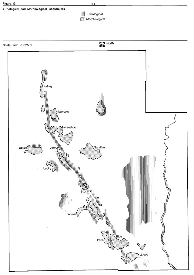
Enlarge figure 13: Lithological and morphological contraints (PDF)
Campground development potential
Figure 14 identifies those areas best suited for campground (A and C), and group campground development (B), campground redevelopment (E), a concession area (D) and day-use expansion (F). None of these areas contain sensitive features and all are in close proximity to existing development.
Campground development is presently centered around Blue, Park and Lloyd lakes (107 sites). These campgrounds can annually accommodate 19,642 camper-days. The optimum campground development for Greenwater is 207 sites (47,263 camper-days annually) while the maximum potential campground development approaches 300 sites. Because of an attempt to maintain water quality in park lakes and because of the limited user capacity of many of the park lakes, the maximum campsite development for the park was not utilized.
The annual capacity for water based activities on Green Lake has been identified as 914 user-days per ha per year or approximately 12,395 user-days per year. This capacity is the maximum use Green Lake can sustain without deterioration of its water quality. (A modified ’userday-water quality index formula, taken from the Ministry of Natural Resources’ Lake Planning manual was used to generate this capacity (Appendix 6). During 1977 approximately 5,536 day-users visited the Green Lake day-use area. The facilities, at present, experience no overcrowding during the week but on weekends, holidays and periods of hot weather the maximum capacity is regularly reached. At the present level of development, the day-use area can accommodate approximately 201 users at any one time. A potential exists to increase this capacity to 490 users per day or 45,570 user-days annually to accommodate peak loading periods. Because Green Lake can accommodate an additional 5,809 user-days over and above the present use, then future expansion of the day-use seems both feasible and environmentally sound.
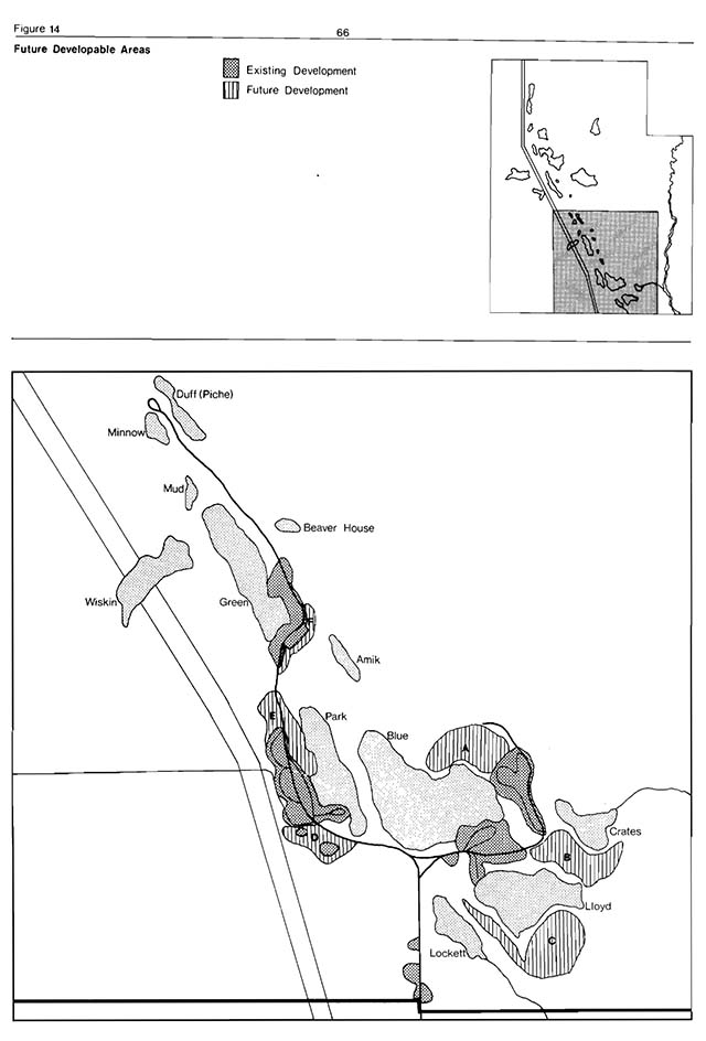
Enlarge figure 14: Future developable areas (PDF)
8.0 Park policy
8.1 Park goal
To provide, within a natural environment setting, quality recreational and educational experiences for both local and non-local visitors.
8.2 Park objectives
Greenwater Provincial Park’s significant and representative life and earth scien e feature contribute to the Natural Environment class of parks.
Combined, these relatively sensitive park resources provide the visitor with a natural environment setting suitable for camping, canoeing, wildlife viewing, scientific research, backcountry travel, fishing, swimming and picnicking.
Given this level of sensitivity and range of opportunities the following objectives were formulated.
Camping
To provide 47,263 camper-days annually in structured campgrounds and to provide facilities to accommodate a maximum of 100 group campers.
Day-use
To provide within a natural setting 22,500 user-days of picnicking and swirruning opportunities annually.
Backcountry recreation
To annually provide 300 camper-days and 6,000 user-days of land-based backcountry recreation opportunities.
Resource management
To manage the existing park land and water resources in a manner that will maintain their natural, interpretive, cultural and recreational values.
Visitor services
To aid park visitors in understanding, utilizing and enjoying the full recreational, interpretive and educational potential of Greenwater Provincial Park.
8.3 Park origin and name
With the increased demand for outdoor recreation facilities during the mid 1950s, Lands and Forests field staff were requested to identify candidate provincial park areas. One area selected was the esker complex located in Colquhoun, Leitch and Calder townships. At that time, the proximity of this area to the King’s Highway 11 (12.9 km) made it an attractive site for a provincial park.
Greenwater Provincial Park originally received its name from Green Lake which displays a peculiar green colour which is believed to stem from its high calcium content. It is one of the many kettle lakes scattered throughout the esker complex.
8.4 Park classification
Because of Greenwater’s natural featres and because of its established role as a destination and stopover park it is recommended that Greenwater remain classified as a Natural Environment Park.
9.0 Park management policies
The following are the principal park management policies applicable to the park and essential to the attainment of park objectives.
9.1 Environmental quality
Only activities which cause little or no deterioration of the park’s natural values will be permitted. All park development programs will be carried out in a manner least detrimental to these values.
Outboard motors will not be permitted to operate on park waters. Regulatory approval will be sought to exempt electric motors, 5 hp or less from this policy.
The present high water qualities of the park lakes and Deception Creek will be maintained and closely monitored.
Garbage will be disposed of outside the park area.
Herbicide spraying will be permitted only on selected sections of the Ontario Hydro and Abitibi Paper Companys transmission lines. The spraying will be performed only under closely monitored conditions.
Insecticide spraying will be permitted only in the development zone and only in exceptional circumstances, as approved by the District Manager.
The use of live bait fish will not be permitted in reclaimed park waters.
Lake reclamations will be permitted in the Natural Environment and Development zones.
9.2 Vegetation management
The policies outlined in the Vegetation Management Plan will be adhered to. The plan will be reviewed every five years.
Tree removal will only be permitted where it contributes to the park’s environmental, recreational and educational objectives. The introduction of non-native species will not be permitted. All wildfires in the park will be extinguished as soon as possible. District fire staff will be familiar with the Greenwater Provincial Park Fire Plan.
9.3 Fisheries management
The park’s sport fishery will be managed according to the Greenwater Provincial Park Fisheries Management Plan. The plan will be reviewed every five years. The present “put and delayed take” cold water trout fishery will be maintained. Commercial fishing will not be permitted within the park.
9.4 Wildlife management
The park’s wildlife resources will be managed according to the Greenwater Provincial Park Wildlife Management Plan. The plan will be reviewed every five years.
Commercial trapping is not permitted in Natural Environment Parks; however, due to the regularity with which Greenwater Provincial Park is faced with nuisance beaver and because park staff are not usually qualified trappers, it has been decided to permit under Ministry control, maintenance trappingof nuisance beaver on a regular basis. This will facilitate control of the beaver population by a known and reputable trapper within guidelines outlined by park staff and in keeping with park objectives.
Hunting will not be permitted.
Wildlife viewing and interpretation will be encouraged.
Introductions of non-native fauna will not be permitted.
9.5 Land management
Mineral exploration or extraction will not be permitted within the park.
No new hydro corridors will be permitted unless necessary for the park’s objectives. Any additional hydro lines should be underground.
No further land use permits will be issued and the existing one on Deception creek will be phased out.
9.6 Park development
Major park development will only be permitted in areas designated by this master plan.
The existing park access road will remain as the only point of public vehicular access. The present access road northeast of Green Lake will not be developed beyond the Duff (Piche) Lake turn-around.
9.7 Visitor services
The visitor services program will be operated according to the Northern Region Parks System Visitor Services Plan. The plan will be reviewed every five years.
Historic vatues, relating to the clay belt farming sub-theme, will be identified and emphasized more in park interpretive programs.
9.8 Emergency situations
In the event of a forest fire occurring within or near the park the parks Fire Management Plan will be utilized. This plan will be reviewed annually by the Cochrane District Staff.
Evacuation of Greenwater Provincial Park (if necessary) will be in accordance with the parks evacuation plan. This plan will be reviewed annually.
9.9 Park services
The park will be operated according to the guidelines laid down in the Greenwater Provincial Park Management and Operating Plan. This plan will be reviewed annually by the Cochrane District Staff.
The operating plan is prepared in accord with the Greenwater Provincial Park Master Plan. The plan includes detailed staffing, park maintenance, development and operational guidelines.
9.10 Other management guidelines
Specialized motor vehicales (i.e. snowmobiles, all-terrain vehicles, dune buggies, mopeds, 4-wheel drive trucks, motorcycles, trail bikes and mini-bikes) will only be permitted on the park access roads.
Recreational facilities will be modified where possible to accommodate handicapped visitors (e.g. reserved campsites adjacent to comfort stations, ramps to building entrances).
Harvesting of edible plants and fruits as part of the visitor services program will be permitted except in nature reserve zones.
10.0 Park zones
In determining the zone designations, consideration was given to sensitive and representative natural features, significant historical resources, and the development potential in Greenwater Provincial Park. Nine zones were delineated: two natural environment zones, six nature reserve zones, and one development zone (Figure 15). An historic area is recommended within one of the natural environment zones.
10.1 Nature reserve zones
Location
All six nature reserve zones protect significant natural resources and provide opportunities for related research and education programs. The nature reserve zones contain features that are representative of an important regional element of geomorphology or vegetation. These features are presently under-represented in the Northern Region parks system and are of sufficient high quality that they would be difficult to duplicate elsewhere in the region. Each zone incorporates a buffer area to ensure the protection and perpetuation of its significant features.
The Black Spruce-Tamarack Treed Bog is included in a nature reserve zone and occupies 321 ha of a mature, undisturbed bog association east of Green Lake. The boundaries of this zone follow the line of differentiation between the undisturbed treed bog and the surrounding disturbed vegetation. The north and west boundaries of this zone mark the edge of a regenerated forest which resulted from a forest fire. The east and south boundaries abut areas disturbed by past logging operations. To date, no other park in the clay belt region is known to contain an undisturbed, regionally significant bog site of this size (with the possible exception of Pierre-Montreuil Park Reserve). The significance of the treed bog lies in its successional development, size, undisturbed nature, age and the presence of plant species considered rare and scarce to the Clay Belt.
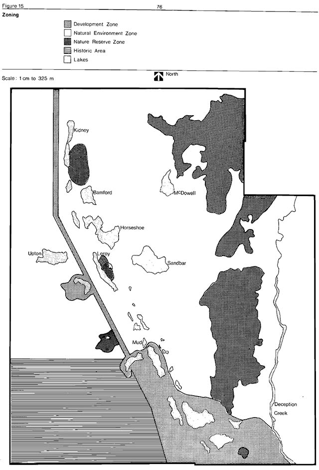
Enlarge figure 15: Zoning (PDF)
The second nature reserve zone is located southeast of Lloyd Lake and encompasses 4 ha of Open Floating Bog Mat Association. The boundary of this zone identifies the limit of the bog’s drainage basin. The forested slopes, surrounding the bog, will act as a buffer area which will ensure the protection of the bog feature from any adjacent development activities. The importance of this bog site centres on its successional development, relatively undisturbed nature, age and the presence of plant species considered rare and scarce to the clay belt region.
The third nature reserve zone encloses a 22 ha Open Floating Bog Mat Association northwest of Wiskin Lake. The boundary of this zone is defined by the bog’s drainage basin. This boundary protects the site from disturbance. The importance of this bog site is similar to the above-mentioned open floating bog mat association (southeast of Lloyd Lake).
The fourth nature reserve zone encompasses 234 ha of Black Spruce Forest Complex in the northeast corner of the park. The north, west, and southwest boundaries of this zone abut recently cut over areas. The east boundary follows the park boundary line. The south and southeast boundaries mark the limits of a past forest fire. The significance of this complex lies in its age, relatively undisturbed nature, successional development, size and the presence of plant species considered rare and scarce to the clay belt region represents an example of a mature undisturbed black spruce lowland forest, typical of the Clay Belt Boreal Forest.
The fifth and sixth nature reserve zones include a 37 ha and 9 ha cross-section of the Greenwater Esker Complex southeast of Kidney Lake and east of Leroy Lake respectively. The purpose of these zones is to preserve within the region a topographical profile of the glacial landforms represented in the park. An esker ridge (61 m high) an outwash plain, dry troughs and a kettle lake are included in these two zones.
Management
Interpretive programs will be prepared which explain the park’s vegetation succession and glacial history. Hiking and selfguiding nature trails will follow the periphery of some of the nature reserve zones. The recreational uses that are compatible with these zones are viewing, photography, nature study, cross-country skiing, snowshoeing and painting. Timber harvesting will not be permitted except to remove hazardous trees along the trails. No tending or site preparation will be allowed. Fire suppression techniques which minimize environmental damage will be used in these sensitive zones. Collecting of plant or wildlife specimens within these zones will be forbidden unless done for scientific purposes. Non-destructive nature interpretation and scientific research will be encouraged. All scientific research will have to be sanctioned by the Ministry of Natural Resources (District Office). A copy of all research reports will be submitted to the Cochrane District Office.
10.2 Natural environmental zones
Location
Two natural environment zones have been established in the park. Both zones buffer the development zone from the nature reserve zones. They provide good opportunities for canoeing, hiking and fishing. The smallest occupies 1,529 ha of the parkland west of the hydro corridor. Upton Lake is the only lake found in this zone. The southernmost 748 ha of this zone has been designated as an historic area. This area represents the pioneer farming theme in the Great Clay Belt.
The second natural environment zone occupies 2,647 ha of the parkland east of the hydro corridor. The east and north boundaries of this zone follow the park boundary lines. The west boundary is the hydro corridor. The south boundary follows a line north of Park and Blue lakes. Deception Creek and thirteen of the park lakes (McDowell, Kidney, Bamford, Horseshoe, Leroy, Minnow, Mud, (Dales), Brown, Beaverhouse, Amik, Duff (Piche) and Sandbar) are located in this zone. A large section of the esker complex is also found in this zone.
Management
Within these zones intensive fishery management practices will take place. This includes stocking of native fish species (“put and delayed take” basis), lake reclamations and sampling of fish populations. The use of live bait fish will not be permitted in reclaimed park waters.
Extraction of timber and silvicultural practices will be permitted where such action contributes to the environmental, recreational and educational objective of the park. Hand tending, site preparation and other forest management practices will be restricted to the demonstration area in the southwest corner of the park. These forestry techniques will be performed on a small scale for interpretive and educational purposes. Wildlife and plant specimens may be taken if approved as a scientific research project by the Ministry of Natural Resources. Agricultural practices will be encouraged in the historic area of the natural environment zone (west of the hydro line) if they are justified as an integral part of the parks interpretive and educational objectives. Recreational activities permitted in this zone include hiking, canoeing, fishing, viewing, photography, cross-country skiing, snowshoeing, interior camping, painting and scientific study. Vehicle access to Deception Creek will be via Concession road 10 and 11, Clute Township. A portage trail to Deception Creek will be established within the park. The existing land use permit will be phased out. All improvements will be removed. The canoeing potential of Deception Creek will be encouraged by the development of portage trails and wildlife viewing platforms.
10.3 Development zone
Location
The development zone is located in the southeast section of the park and covers 557 ha (10 percent of the park). This zone provides for access to the park and for the provision of support recreation facilities for day-use and camping purposes. All major park development, the potential developable areas and the hydro corridor are included in this zone. Eight lakes (Wiskin, Lloyd, Lucky, Blue, Green, Crates, Park and Lockett) are also found in this zone. Five of these lakes host “put and delayed take” trout fisheries. The south boundary of this zone follows the southern park boundary line. The east boundary follows the west shore of Deception Creek, the Crates Lake creek and the southern tip of the “black spruce-tamarack treed bog” nature reserve zone. The boundary then runs north of Park and Blue lakes, east of Green Lake then west to Wiskin Lake. The zone encompasses hydro corridor and a section of the esker complex is also included in this zone.
Management
All high intensity day-use activities will be restricted to designated day-use areas. Camping activities will be confined to designated campgrounds. No electrical outlets will be provided. Maintenance and utility buildings, park gate, staff quarters and a concession will be located in this zone. Fishery management practices will be similar to those followed in the natural environment zones. The use of live bait fish is not permitted in reclaimed lakes.
11.0 Visitor/ resource relationship
11.1 Visitor services
How do park visitors benefit from Greenwater Provincial Park? The relevancy of this question seems evident when one reviews the contents of this master plan. To this juncture, the plan has described and discussed park resources in detail, their significance and sensitivity; but, in very few locations has it explained how park visitors can come to Greenwater and gain interpretive, recreational and outdoor educational experiences. A visitor services program has been developed for Greenwater to enable park visitors to utilize and gain from park resources. Therefore, the objective of the visitor services program is to aid park visitors in understanding and enjoying the full interpretive, recreational and educational potential of Greenwater Provincial Park.
The visitor services program for Greenwater Provincial Park will emphasize two components: interpretation and communication.
The present interpretive opportunities available at Greenwater include one self-guiding interpretive trail - Green Trail, conducted hikes by scheduling, six hiking trails, a young people’s program, wilderness cook-out demonstrations and evening programs consisting of mainly park-related movies and nature films.
Several additional interpretive-recreational projects will be incoporated into the visitor services program at the park.
A combination display panel-shelter unit is proposed for the entrance to Green Trail. Additional hiking trails will be developed (loop-type) for moderate and avid hikers.
Another project will be the development of several sand tracks in the different community types within the park. The naturalist will interpret to the park visitor the tracks of the various types of mammals, insects and amphibians that inhabit the park.
A canoe route will be established along Deception Creek from Concession 10 and 11 to the falls. A brochure will be published which will describe the highlights of the area.
Scenic lookouts and viewing platforms are recommended along the central esker ridge and Deception Creek. Display panels will also be constructed at these sites to interpret the geology, wildlife and vegetation of the area.
New activities are proposed as part of the young people’s program at the park. These will include nature arts and crafts, bird watching, poster contests (park motif ideas), soil studies, aquatic life studies, litter collecting contests and other projects that will provide the young campers with a learning experience.
The wilderness cook-out program will be continued with a demonstration of wild edible plants and their uses.
Interpretation
The interpretive component will relate the park’s themes to the visitor. The major earth science theme is the deglaciation history of the park. With use of publications, audio-visual presentations and exhibits, the park’s surficial geology will be related to the overall Pleistocene history of the region. The differences from and similarities to Esker Lakes Provincial Park will be explored. The historical theme combines the theme segments of “Clay Belts”, North Central Ontario “Pulp and Paper” and “Modern Ontario” (particularly the rural depopulation and Great Depression aspects). These three segments are all closely related.
No other park in the province examplifies as well this locally important historical theme. While some limited “homesteading” occurred within the park boundaries, a complete development of this theme will make visitors aware of resources outside of Greenwater such as the Kapuskasing Experimental Farm and abandoned farmland in the Cochrane area and paper mill tours at Smooth Rock Falls androquois Falls and the Cochrane Train Museum. These historical themes will be related to and compared with their counterparts at Kap-Kig-Iwan.
Communication
The communication component of the visitor services program at Greenwater will be provided by the personal services of all park staff members. They will inform the park visitor of the facilities and services available in the park and local area. At present, the formal visitor services staffing for Greenwater is one seasonal park naturalist and an assistant. These people will be a major source of park information and act as public relations agents.
The information media consists of park related publications including newsletters, self-guiding trail pamphlets, plant, bird and mammal checklists, and a publication on “Geese at Greenwaten” Also in use are signs announcing upcoming interpretive events nd an audio visual program which introduces the park’s master plan to the visitors.
Recreation
The visitor services program will encourage the park visitor to participate in various recreational activities within the park environment related to the park themes. Fishing, hiking and canoeing (Deception Creek) are the most popular activities that will be emphasized in the park’s interpretive program. The visitor services staff will provide information concerning the types of trails and their 85 mileage, the fish stocking schedules, prime fishing spots, fish species available in the park and Deception Creek, and the size and location of the larger catches.
Greenwater Provincial Park is a Natural Environment Park with an esker complex dominating its central section. Small clear lakes parallel the base of the esker. Several of these lakes are stocked with brook, rainbow and lake trout species on a “put and delayed take” basis. A moderate activity program concentrating on fishing skills will be introduced. The program will also inform the park visitor about fishing opportunities available in the surrounding areas.
Greenwater, next to Esker Lakes Provincial Park is the most appropriate Northern Region park for a canoeing skills program. It will be attempted at Greenwater only after a careful evaluation of the Esker Lakes’ program.
An extended use trail into the park’s interior will be developed, providing resting sites along the route and primitive campsites at the end or part way along the trail. A system of cross-country ski trails (9.65 km) and snowshoe trails (2.4 km) is also recommended.
Outdoor education
Here is as yet no firm policy concerning the Ministry of Natural Resources’ involvement in this field.
At present, the visitor services program will aid Board of Educations in the following ways: by providing resource information, guidance for planning field trips, occasionally participating in field trips as resource specialists and by occasional lectures and audio-visual presentations at local schools.
12.0 Park development and management
12.1 Park concept
Several development possibilities were examined for Greenwater before a final development concept was accepted. Appendix 5 summaries the various alternatives which were considered while the discussion below gives specific details for the accepted development plan for the park (Figure 16).
12.2 Development
The recommended development zone for Greenwater Provincial Park contains an intensive day-use area and three campgrounds. The present state of development limits possible alternatives to the following:
Camping
Current demand trends indicate that the optimum. occupancy rate of 60 percent for the 107 campsites will be reached by 1981. Recommended projected campsite development is a maximum of 207 sites. Development may commence in 1980-81 to maintain occupancy levels at approximately 60 percent. New campsite development should take place in three phases of 50, 25 and 25 sites. Supporting facilities will take place concurrent to campsite development. Development will result in a total of four campgrounds and one group camping area. The group camping facilities will be developed northeast of Lloyd Lake to accommodate a maximum of 100 campers at any one time.
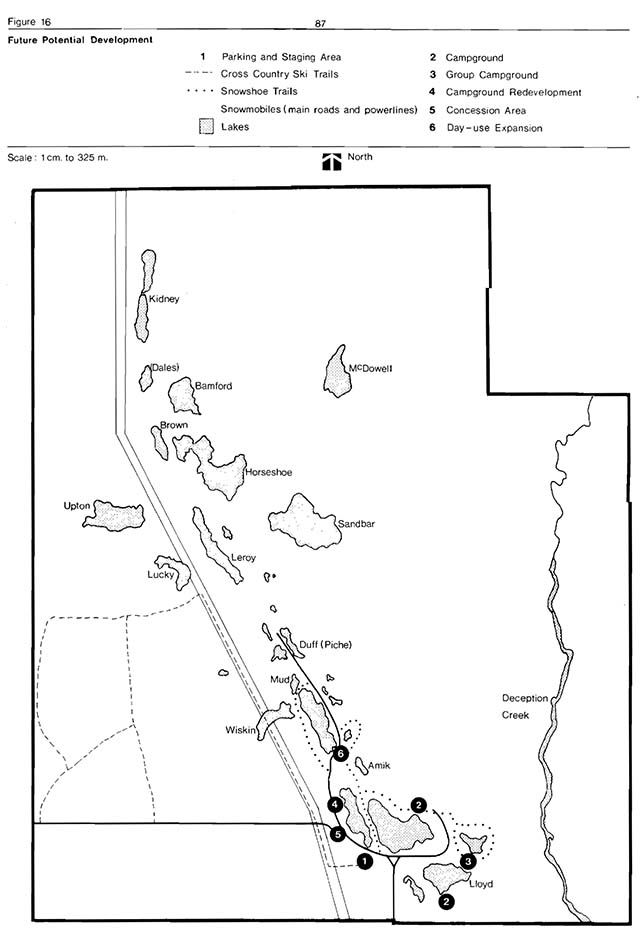
Enlarge figure 16: Future potential development (PDF)
Intensive day use area
The day-use development area is located at the south end of Green Lake and receives considerable pressure particularly from local residents. Also a new highway development from Timmins to Highway 11 at Driftwood, (13 km southwest of Greenwater) will provide easier access to the park for Timmins residents and will result in a substantial increase in park visitation. A 1975 District proposal (Ladoucer and Flood) exists to expand the existing 1.2 ha of day-use area to 2.75 ha. The estimated potential for the present day-use site is a maximum daily capacity of 201 user-days. The proposed expansion would allow for a maximum daily total capacity of 490 user-days/day. No other intensive day-use areas are recommended.
Phasing
Table 10 indicates the principal present and proposed park facilities. Three phases of development are recommended. While it is unlikely that any particular phase will take place concurrently the master plan team recommends the completion of Phase before proceeding to Phase I. Table 11 [reproduced as a list for accessibility] identifies the proposed phasing of development.
12.3 Concession building
It is recommended that, at a future date, a concession building be constructed and leased in the general location of the former Junior Ranger camp. The establishment of a concession within the park would facilitate the refuse control (i.e. types of products to be sold), provide additional services to the park user, and would be available should it be necessary to sell firewood in the future.
Table 10: Park facilities - Present and proposed
| Facility type | Present | Proposed addition | Total |
|---|---|---|---|
| Day use area - Beach dry | 558 m2 | 929 m2 | 1,487 m2 |
| Day-use area - Beach (wet) | 558 m2 | 1,484 m2 | 2,041 m2 |
| Day use area - Picnic area | 1.15 ha | 1.28 ha | 2.43 ha |
| Day use area - Group picnic area | - | - | - |
| Day use area - Parking area (vehicles) | 106 | 98 | 204 |
| Campgrounds - Campsite units | 107 | 103 | 210 |
| Campgrounds - Group camping area | - | 1 | 1 |
| Utilities - Water Pressure System | 1 | - | 1 |
| Utilities - Water Lines | 4.8 km | 3.2 | 8.0 |
| Utilities - Trailer Filling | 1 | - | 1 |
| Utilities - Trailer Filling and Dumping | 1 | - | 1 |
| Utilities - Transmission lines - overhead | 1.2 km | - | 1.2 |
| Utilities - Transmission lines - underground | 0.4 km | - | 1.2 |
| Refuse Sites | 3 | 3 | 6 |
| Buildings - Administration office | - | 1 | 1 |
| Buildings - Entrance Control Booth | 1 | - | 1 |
| Buildings - Summer staff quarters | 1 | - | 1 |
| Buildings - Maintenance building | 1 | 1 | 2 |
| Buildings - Concession | - | 1 | 1 |
| Buildings - Change houses | 2 | - | 2 |
| Buildings - Comfort Station | - | 1 | 1 |
| Buildings - Type 2 Vault Privy | 11 | 2 | 13 |
| Buildings - Type 2 Vault Privy (basin) | 1 | 1 | 2 |
| Buildings - Vault Privy (Centennial + 1) | 1 | - | 1 |
| Buildings - Picnic Shelter | 1 | 1 | 1 |
| Buildings - Gas Storage Buildings | - | 1 | 1 |
| Buildings - Pumphouse | 1 | - | 1 |
| Buildings - Shower-Laundromat complex | 1 | - | 1 |
| Roads and trails - Paved - one way | - | - | - |
| Roads and trails - Paved - two way | .96 km | 1.6 km | 2.6 km |
| Roads and trails - Gravel - one way | 3.22 km | - | - |
| Roads and trails - Gravel - two way | 4.83 km | - | - |
| Trails - Int (self) | 1.2 km | 4.83 km | 6.0 km |
| Trails - Hiking | 11.8 km | 32.18 km | 43.9 km |
| Trails - Cross-country ski | - | 9.65 km | 9.65 km |
| Trails - Snowmobile | 12.87 km | - | 12.87 km |
| Trails - Snowshoe | - | 2.4 km | 2.4 km |
| Structures - Lookouts | 1 | 2 | 3 |
| Structures - Amphitheatre | - | 1 | 1 |
| Structures - Outdoor Exhibits | - | 2 | 2 |
| Structures - Docks | 6 | 4 | 10 |
| Other - Canoe route | 4.8 km | - | 4.8 |
| Other - Playground | - | 1 | 1 |
Table 11: Proposed phasing of development
[reproduced as a list for accessibility]
- Phase I
- Green Lake day-use expansion
- Wet and dry beach re-development - to expand an additional 2,413 m2
- Picnic area development - to expand an additional 1.2 ha
- Comfort Station - Type 9
- Playground - to construct log play equipment
- Road re-development -.55 km
- Parkng Area - to construct an additional 98 car parking lot
- Picnic Shelter
- Blue Lake campground development
- Campsite units - to construct 50 campsite units with related facilities (water, roads,vault toilets)
- Group camping area - to construct a.81 ha camping area
- Road access - to construct.5 km road to group camping area
- Green Lake day-use expansion
- Phase II
- Buildings
- Administration Office Vault Privies - to construct 3 sets
- Gas Storage
- Docks - to construct 4 docks
- Self-guiding trail - to develop 4.8 km of trail
- Cross-country ski trail - to develop 9.7 km of trail
- Canoe route - to develop campsites on Deception Creek
- Lloyd Lake Campground development
- Campsite units - to construct 25 campsite units plus related facilities
- Road development - to Lloyd Lake -
- Trailer filling and dumping station
- Comfort Station - Type 7
- Hiking Trai1 - to construct 32.2 km of trail
- Lookout - to construct 2 lookouts
- Amphitheatre -
- Maintenance building
- Deception Creek road -to construct 1.2 km of access road
- Buildings
- Phase III
- Lloyd Lake Campground Development
- Campsite units- to construct 25 campsite units plus related facilities
- Comfort Station - Type 7
- Lloyd Lake Campground Development
12.4 Backcountry recreation development
The park trails system will be expanded from the present 11.8 km to a maximum of 37 km of interpretive, hiking and lake access trails, as demand warrants. A 10.15 km trail to the Deception Creek falls area will be developed in the near future (Figure 16).
Approximately 15 interior campsites will be developed. Two potential locations are the north central portion of the park along the esker ridge and the Deception Creek area.
No official snowmobile trails are planned other than existing roads and powelines. There is, however, considerable potential for snowshoe and cross-country ski trails (Figure 16). Winter day-use and camping opportunities will undoubtedly exceed demand for some time to come. The present north access road will be eliminated beyond Duff (Piche) Lake and turned into a walking trail with interior campsites.
12.5 Visitor services
Future recommendations include the development of an interpretive centre with a children’s playground, amphitheatre, and display area. Additional nature trails will be established in locations such as the Deception Creek Falls and Sandbar Lake. Other facilities such as display panels and wildlife viewing platforms will be erected as required.
13.0 Park operations and management
13.1 Staffing
All park staff members must be knowledgeable of the park goal and objectives as they relate to the management of the park resources. Similarly, park staff must be trained to carry out resource management strategies as outlined in this plan. The existing staff structure in Greenwater Provincial Park is:
| Position | Classification | Status |
|---|---|---|
| Park Superintendent | R.T.3 | complement |
| Maintenance Foreman | R.T.2 | seasonal |
| 1 Maintenance Technician | R.T.1 | seasonal |
| 2 Gate Attendants | Clerk 2 General | seasonal |
| 1 Visitor Sevices Programmer | R.T.2 | seasonal |
With future expansion and projected increase in use at Greenwater the following staff structure is recommended. Increased staffing will have to be phased in as development and park utilization dictates.
| Position | Classification | Status | Phase |
|---|---|---|---|
| Park Superintendent | R.T.S.1 | complement | I |
| Assistant Park Superintendent | R.T.3 | seasonal | II |
| Maintenance Foreman | R.T.2 | seasonal | II |
| Visitor Services Programmer | Bio 2a | complement | III |
| 2 Maintenance technicians | R.T.1 | seasonal | III |
| 2 Manual workers | Manual worker | seasonal | III |
| 3 Gate attendants | Clerk 2 general | seasonal | II |
| Clerk | Clerk 2 general | seasonal | II |
| Security officer | Sec. Off. 2 | seasonal | II |
Park superintendent
The park superintendent’s primary responsibilities are the supervision and guidance in the park’s operations, management and development. He must train his staff to be aware of management guidelines thus ensuring that the park objectives are attained. This position must be complement in order to ensure a continuity of program and a smoothly operating, well maintained park.
Visitor services programmer
He/she would be responsible for the park’s Visitor Services program. A complement person in this function would result in greater public awareness and utilization of the park’s resources.
13.2 Park services
Water supply
Greenwater’s primary water source is Blue Lake. Water quality standards have been established for the lake so as to maintain its existing quality.
Electricity
A hydro transmission line services park maintenance and staff buildings. No electrical outlets are planned for park patrons. All future park hydro transmission lines will be buried underground.
Telephone
Access by park visitors, to a public telephone does not exist in Greenwater. However, plans exist to locate a booth either at the park entrance or close by the future concession building. Telephone wires will be buried underground.
Fire protection
Because of the distance of Greenwater from Cochrane, no municipal facilities or equipment are available. Therefore, in the event of a fire the Cochrane District,Office will be responsible for. suppression activities. Suppression services for both structural and forest fires will be provided by Cochrane District Office with initial action normally the responsibility of park staff.
Emergency services
An emergency plan has been prepared for park staff. Staff will be trained and familiar with it.
Sanitary facilities
Ministry of Natural Resources and Ministry of Health standards will be followed.
Rowdyism and vandalism control
Rowdyism and vandalism are not major problems within Greenwater, however, control programs have been prepared which stress the education and public contact by all staff. Day-to-day enforcement will be carried out by designated park wardens and off-duty conservation officers. In difficult situations, the Cochrane detachment of the Ontario Provincial Police will supplement park enforcement officers.
13.3 Park operating plan
A park operating plan has been prepared for Greenwater. It contains detailed financial management and park maintenance guidelines.
14.0 Program implementation
14.1 Monitoring
Following implementation of this master plan and the accompanying management plans, it will be reviewed at least every five years. Data collection and assessment required to detect environmental degradation, changing natural patterns and user demands will be carried out regularly.
14.2 Land disposition
The existing Land Use Permit on Deception Creek will be phased out.
14.3 Fish and wildlife
Following implementation of this master plan, the use of live bait fish will be prohibited in reclaimed park waters.
14.4 Electric outboard motors
Pending SE0.54 approval, the total ban on all types of outboard motors may exempt electric motors in Greenwater Provincial Park. This change in the regulations under the Provincial Parks Act is being recommended as a result of public input and an overview of the policy.
Summary of management plans
15.0 Visitor service plan
15.1 Objective
To aid park visitors in recognizing, utilizing and enjoying the full recreational, interpretive and educational potential of Greenwater Provincial Park.
15.2 Interpretive strategies
- A public communications program will be provided through personalcommunications by park staff members, park-related literature and displays. The park visitor will be informed of the park and area resources, facilities, services, programs and regulations.
- An interpretive program of modest intensity will be provided for the park visitor through self-use media (i.e. self-guiding trails)and facilities and organized activities (i.e. evening programs, young people’s programs). Two important park themes will be emphasized: the deglaciation history and pioneer farming inthe Great Clay Belt.
- Recreational activities (i.e. hiking, canoeing, fishing) which relate strongly to the themes of the interpretive program will be provided.
- Educational groups and charitable organizations will be encouraged to make use of the, park system for outdoor education and recreational purposes.
16.0 Fisheries Management Plan
16.1 Objective
To outline necessary fisheries management practices that will provide park users and local residents with.a quality recreational sports fishery within the boundaries of Greenwater Provincial Park.
16.2 General management strategies
The park lakes found capable of supporting sport fisheries will be managed using the following strategies:
- Introductions of appropriate fish species into suitable lakes.
- Regular surveys will be conducted to evaluate the status of the fish populations within the various lakes and Deception Creek.
- Periodic water analysis (oxygen, dissolved solids, temperature, pH) will be performed on the park lakes to monitor the suitability of the various park lakes for supporting sport fisheries.
The plan also includes collection of data on the fish and invertebrate species distribution and their habitat requirements in the park lakes, the physical and chemical properties of the park lakes and Deception Creek, trout stockings (1950-1976), creel censuses and dissolved oxygen tests.
16.3 Trout fishery
The trout waters of the park (i.e. waters presently capable of supporting trout fisheries) include Blue, Lloyd, Green, Park, Wiskin, Duff (Piche), Kidney and Leroy lakes and the north section of Deception Creek. General recommendations proposed for the trout fishery are as follows:
- Reclamation of lakes suitable for trout species.
- The use of live bait fish will be prohibited in reclaimed park lakes.
- Kidney, Duff (Piche) and Wiskin lakes will be tested each year in early April for dissolved oxygen levels.
- Where feasible, all stocking should be done by truck. Helicopters should be used to stock inaccessible lakes on which fixedwing aircraft cannot land. All stocking of yearling trout should be done in the spring. When barren or reclaimed waters are to be stocked, consideration should be given to planting fingerlings or fry in the autumn.
- Signs indicating the trails to the park lakes should list the lake name and inhabiting fish species.
- A four year proposed fish stocking plan should be followed (Table 22, Fisheries Management Plan).
- A stream survey and limited creel census (voluntary) is recommended for Deception Creek to increase our knowledge of the creek.
16.4 Fishery with limited trout potential
The park waters with potential for warm water species only (pike, perch and pickerel waters) include Horseshoe, Lucky, Upton, Sandbar and Brown lakes, and the south section of Deception Creek. Overall recommendations for these areas are as follows:
- Proper access trails to the lakes should be provided and signs posted indicating the direction, distance, lake name and fish species present in each lake.
- Park personnel should publicize to the park visitor the northern pike in Horseshoe Lake and the large numbers of yellow perch in Lucky, Upton, Sandbar, Lloyd and Brown lakes.
16.5 General recomendatons
A voluntary surrmer creel census program similar to the 1976 and 1977 surveys should be conducted as required.
16.6 The relation of the sport fishery to park master plan zones
Five of the eight park lakes (i.e. Park, Green, Blue, Lloyd and Wiskin) which are stocked with trout species are located in the development zone. Duff (Piche), Leroy and Kidney lakes are situated in a natural environment zone.
None of the activities associated with the Greenwater Provincial Park sport fishery conflict with provincial administrative policies for development and natural environment zones within natural environment parks.
17.0 Wildlife management plan
17.1 Objective
To outline policies and procedures that will be used to manage the wildlife resources within Greenwater Provincial Park in accordance with the environmental, recreational and educational objectives of the park.
17.2 Management strategies
The following are strategies that will be utilized to manage the wildlife resources of the park:
- No hunting will be permitted.
- Trapping of nuisance beaver will be allowed in all the park zones except the Nature Reserve Zone. A small resident population of peaver will be maintained in the development zone specifically for interpretive purposes.
- Moose will be encouraged to frequent selected viewing sites by providing salt licks (i.e. Deception Creek and Bamford Lake).
- Approximately 25 nest boxes will be located in the park where suitable duck brood cover exists for hole-nesting ducks.
- A captive flock of wild geese will be maintained at a maximum of 3 breeding pairs. Extra goslings will be allowed to fledge and revert to the wild.
- The mowing of road shoulders will be continued. Shrub and tree regeneration will be controlled by hand brushing.
- Nuisance bears will be removed.
- All wildlife management practices will be interpreted, where possible, through the visitor services program.
- Wildlife research will be encouraged, provided there is not conflict with park objectives.
18.0 Vegetation management plan
18.1 Objective
To outline the policies and procedures that will maintain a vegetation resource complementary to park objectives.
18.2 Management strategies
The following are strategies that will be utilized to manage the vegetation resources of the park:
- Normal commercial cutting will not be permitted. Timber extraction will be allowed where such action contributes to the environmental, recreational and educational objectives for each park zone.
- Areas demonstrating forestry management and silvicultural techniques will be established (funds permitting) and included in the parks interpretive program.
- Vegetation conditions suitable for maintaining wildlife populations will be protected wherever practical.
- Extensive insecticide spraying may be permitted in the development zone.
18.3 Special consideration by zone
- The nature reserve zones will be left undisturbed and access, where necessary, will be by boardwalk trails.
- The vegetation management strategy in the development zone will be to manage the forest resource through the elimination of hazardous trees and replanting. A tree nursery will be maintained under the power lines. Plantations near Park Lake and the staff quarters will be thinned using a Vermeer tree spade. The trees will be relocated in the campgrounds to regenerate selected sites.
- The areas contained in the natural environment zones will be allowed to grow and regenerate naturally. Plantations in the outwash plain area will be replanted if it becomes necessary to again stabilize the esker and associated ridges. The southwest corner of the natural environment zone (west of the power line) will be developed into a demonstration area (with available funds) to show sound forestry management practices to the park visitor through the interpretive program.
Appendices
Appendix 1: Checklist of vascular plants
- Equisetaceae
- Equisetum
- arvense - field horsetail
- fluviatile - water horsetail
- hyemale - scouring-rush
- pratense - meadow horsetail
- scirpoides - dwarf scouring rush
- sylvaticum - wood horse tail
- Equisetum
- Lycopodiaceae
- Lycopodium
- annotinum - bristly clubmoss
- clavatum - running moss
- complanetum - ground cedar
- obscurum - ground pine
- Lycopodium
- Ophioglossaceae
- Botrychium
- lunaria - moonwort
- matricariaefolium - grape fern
- virginianum - rattlesnake fern
- Botrychium
- Osmundaceae
- Osmunda
- claytoniana - interrupted fern
- Osmunda
- Polypodiaceae
- Athyrium
- felix-femina - lady fern
- Cystopteris
- bulbifera - bulblet fern
- Dryopteris
- disjuncta - oak fern
- phergopteris - long beech fern
- spinulosa - spinulose wood fern
- Onoclea
- sensibilis - sensitive fern
- Pteretis
- pensylvanica - ostrich fern
- Pteridium
- aquilinun - bracken fern
- Athyrium
- Taxaceae
- Taxus
- Canadensis - American yew
- Taxus
- Pinaceae
- Abies
- balsamea - balsam fir
- Larix
- laricina - tamarack
- Picea
- glauca - white spruce
- mariana - black spruce
- Pinus
- banksiana - jack pine
- resinosa - red pine
- strobus - white pine
- Abies
- Cupressaceae
- Thuja
- occidentalis - white cedar
- Thuja
- Typhaceae
- Typha
- latifolia - common cat-tail
- Typha
- Sparganiaceae
- Sparganium
- angustifolium - bur-reed
- Sparganium
- Zosteraceae
- Potamogeton
- gramineus - pondweed
- natans - pondweed
- Richardsonii - pondweed
- Potamogeton
- Juncaginaceae
- Triglochin
- maritima - arrow-grass
- Scheuchzeria
- palustris - arrow-grass
- Triglochin
- Alismataceae
- Sagittaria
- cuneata - arrowhead
- latifolia - arrowhead
- Sagittaria
- Hydrocharitaceae
- Elodea
- canadensis - waterweed
- Elodea
- Gramineae
- Calamagrostis
- canadensis - blue-joint
- Danthonia
- spicata - poverty-grass
- Glyceria
- borealis - northern manna-grass
- Oryzopsis
- asperifolia - mountain-rice
- Phleum
- pratense - timothy
- Calamagrostis
- Cyperaceae
- Carex
- cryptolepis - sedge
- exilis - coast sedge
- pauperaula - bog sedge
- stricta - tussock sedge
- trisperma - three-fruited sedge
- Eleocharis
- palustris - creeping spike rush
- Eriophorum
- spissum - cotton-grass
- Scirpus
- hudsonianus - bulrush
- Carex
- Araceae
- Acorus
- calamus - sweetflag
- Calla
- palustris - wild calla
- Acorus
- Lemnaceae
- Lemna
- minor - duckweed
- Lemna
- Juncaceae
- Juncus
- brachycephalus - small-headed rush
- nodosus - knotted rush
- Juncus
- Liliaceae
- Clintonia
- borealis - bluebead lily
- Maianthemum
- canadense - wild lily-of-the-valley
- Smilacina
- trifolia - three-leaved false Solomon’s seal
- Streptopus
- amplexifolius - white mandarin
- roseus - rose twisted stalk
- Tofieldia
- glutinosa - false asphodel
- Trillium
- cernuum - nodding trillium
- Clintonia
- Iridaceae
- Iris
- versicolor - blue flag
- Sysyrinchium
- montanum - blue-eyed grass
- Iris
- Orchidaceae
- Arethusa
- bulbosa - swamp-pink
- Calopogon
- pulchellus - grass pink
- Calypso
- bulbosa - fairy slipper
- Corallorhiza
- maculata - spotted coral-root
- striata - striped coral-root
- trifida - pale coral-root
- Cypripedium
- calceolus - yellow lady’s slipper
- reginae - showy lady’s slipper
- Goodyera
- repens - var. ophioides - dwarf rattlesnake-plaintain
- tesselata - checkered rattlesnake plaintain
- Habenaria
- clavellata - green woodland orchis
- dilatata - leafy white orchis
- Hookeri - Hooker’s orchis
- obtusata - one-leaf rein-orchis
- viridis var. bracteata - long-bracted green orchis
- Listera
- cordata - heartleaf twayblade
- Orchis
- rotundifolia - small round-leaved orchis
- Pogonia
- ophioglossoides - rose pogonia
- Arethusa
- Salicaceae
- Populus
- balsamifera - balsam poplar
- tremuloides - trembling aspen
- Salix
- Bebbiana - long-beaked willow
- humilis - small pussy willow
- Populus
- Corylaceae
- Alnus
- rugosa - speckled alder
- Betula
- glandulosa - swamp birch
- papyrifera - white birch
- Corylus
- cornuta - beaked hazel
- Alnus
- Santalaceae
- Geocaulon
- lividum - northern commandra
- Geocaulon
- Polygonaceae
- Polygonum
- amphibium - water smartweed
- Rumex
- crispus - curled dock
- Polygonum
- Chenopodiaceae
- Chenopodium
- album - lamb’s quarters
- Chenopodium
- Caryophyllaceae
- Cerastium
- vulgatum - mouse-ear chickweed
- Stellaria
- longifolia - long-leaved stitchwort
- Cerastium
- Numphaeaceae
- Nuphar
- variegatum - bull head lily
- Nuphar
- Ranunculaceae
- Actaea
- rubra - red baneberry
- rubra forma neglecta - red baneberry (white form)
- Anemone
- canadensis - Canada anemone
- quinquefolia - wood anemone
- Caltha
- palustris - marsh marigold
- Clematis
- verticillaris - purple clematis
- Coptis
- groenlandica - goldthread
- Ranunculus
- abortivus - small-flowered crowfoot
- acris - red baneberry (white form)
- pensylvanicus - bristly buttercup
- septentrionalis - swamp buttercup
- Thalictrum
- dasycarpum - purple meadow-rue
- polygamum - red baneberry (white form)
- Actaea
- Cruciferae
- Barbarea
- bulgaris - winter-cress
- Capsella
- bursa-pastoris - shepherd’s purse
- Barbarea
- Sarraceniaceae
- Sarracenia
- purpurea - pitcher-plant
- Sarracenia
- Droseraceae
- Drosera
- Linearis - linear-leaved sundew
- rotundifolia - round-leaved sundew
- Drosera
- Saxifragaceae
- Mitella
- nuda - naked miterwort
- Parnassia
- palustris - grass-of-parnassus
- Ribes
- glandulosum - skunk currant
- lacustre - bristly black currant
- triste - red currant
- Mitella
- Rosaceae
- Amelanachier
- bartramiana - mountain juneberry
- spicata - service-berry
- Fragaria
- virginiana - wild strawberry
- Geum
- virginianum - rough avens
- Potentilla
- palustris - marsh cinquefoil
- Prunus
- pensylvanica - pin cherry
- virginiana - choke cherry
- Rosa
- acicularis - prickly rose
- Rubus
- aratiaus - arctic bramble
- idaeus - wild raspberry
- pubescens - dwarf raspberry
- Sorbus
- decora - mountain ash
- Spiraea
- alba - meadow-sweet
- Amelanachier
- Leguminosae
- Astragalus
- alpinus var. brunetianus - alpine milk vetch
- canadensis - Canadian milk vetch
- Lotus
- corniculatus - birds-foot trefoil
- Melilotus
- alba - white sweet clover
- Trifolium
- hybridum - alsike clover
- pratense - red clover
- Astragalus
- Geraniaceae
- Geranium
- bicknelli - Bicknell’s cranesbill
- Geranium
- Aceraceae
- Acer
- spicatum - mountain maple
- Acer
- Balsaminaceae
- Impatiens
- biflora - spotted touch-me-not
- Impatiens
- Rhamnaceae
- Rhamnum
- alnifolia - alder-leaved buckthorn
- Rhamnum
- Guttiferae
- Hypericum virginicum - marsh st. johns-wort
- Violaceae
- Viola
- adunca - hooked-spur violet
- blanda - sweet white violet
- pallens - wild white violet
- renifolia - kidney-leaved violet
- Viola
- Onagraceae
- Circaea
- alpina - smaller enchanter’s nightshade
- Epilobium
- angustifolim - fireweed
- glandulosum - northern willow-herb
- Oenothera
- biennis - evening primrose
- Circaea
- Araliaceae
- Aralia
- nudicaulis - wild sarsaparilla
- hispida - bristly sarsaparilla
- Aralia
- Umbelliferae
- Cicuta
- bulbifera - bulb-bearing hemlock
- Heracleum
- lanatum - cow-parsnip
- Osmorhiza
- claytoni - sweet cicely
- Cicuta
- Cornaceae
- Cornus
- canadensis - bunch berry
- rugosa - round-leaved dogwood
- stolonifera - red osier dogwood
- Cornus
- Pyrolaceae
- Chimaphila
- umbellata - pipsissewa
- Moneses
- uniflora - one-flowered pyrola
- Monotropa
- uniflora - indian-pipe
- Pyrola
- asarifolia - pink pyrola
- elliptica - shin leaf
- minor - lesser pyrola
- secunda - one-sided pyrola
- virens - greenish-flowered pyrola
- Chimaphila
- Ericaceae
- Andromeda
- glaucophylla - bog rosemary
- Chamaedaphne
- calycutata - leatherleaf
- Epigaea
- repens - trailing arbutus
- Gaultheria
- hispidula - creeping snowberry
- Kalmia
- angustifolia - sheep laurel
- polifolia - swamp laurel
- Ledum
- groenlandiaum - labrador tea
- Vaaainium
- angustifolium - low sweet blueberry
- myrtilloides - velvet-leaf blueberry
- oxycoccus - small cranberry
- Andromeda
- Primulaceae
- Lysimachia
- ciliate - fringed loosestrife
- terrestris - swamp candle
- Trientalis
- borealis - starflower
- Lysimachia
- Oleaceae
- Fraxinus
- nigra - black ash
- Fraxinus
- Apocynaceae
- Apocynum
- androsaemifolium - spreading dogbane
- Menyanthes
- trifoliata - buckbean
- Apocynum
- Boraginaceae
- Mertensia
- paniculata - bluebell
- Mertensia
- Labiatae
- Lycopus
- uniflorus - water-horehound
- Mentha
- arvensis - common mint
- Prunella
- vulgaris - heal-all
- Scutellaria
- epilobifolia - common skull cap
- Stachys
- aspera - rough hedge nettle
- Lycopus
- Scrophulariaceae
- Melampyrum
- lineare - cow-wheat
- Mimulus
- glabratus - monkey-flower
- ringens - square stemmed money flower
- Veronica
- americana - American brookline
- Melampyrum
- Lentiblllariaceae
- Utricularia
- intermedia - flat leaved bladderwort
- Utricularia
- Plantaginaceae
- Plantago
- major - common plantain
- Plantago
- Rubiaceae
- Galium
- asprellum - rough bedstraw
- boreale - northern bedstraw
- triflorum - sweet-scented bedstraw
- Galium
- Caprifoliaceae
- Diervilla
- lonicera - northern bush honeysuckle
- Linnaea
- borealis
- Lonicera
- canadensis - fly honeysuckle
- hirosuta - hairy honeysuckle
- involucrata - involucred fly honeysuckle
- villosa - mountain fly honeysuckle
- Sambucus
- pubens - red-berried elder
- Viburnum
- edule - squashberry
- trilobum - high bush cranberry
- Diervilla
- Campanulaceae
- Campanula
- aparinoides - bedstraw bellflower
- Lobelia
- Kalmii - brook lobelia
- Campanula
- Compositae
- Achillea
- millefolium - yarrow
- Anaphalis
- margaritaaea - pearly evelasting
- Antennaria
- neglecta - field pussy-toes
- Arctium
- minus - common burdock
- Aster
- macrophyllus - large-leaved aster
- Bidens
- cernua - bur-marigold
- Chrysanthemum
- leucanthemum - ox-eye daisy
- Cirsium
- arvense - Canada thistle
- Erigeron
- annuus - daisy fleabane
- Hieraaium
- aurantiacum - orange hawkweed
- pratense - king devil hawkweed
- scabrum - rough hawkweed
- Lactuaa
- canadensis - wild lettuce
- Petasites
- palmatus - sweet coltsfoot
- Senecio
- aureus - golden ragwort
- Solidago
- canadensis - Canada goldenrod
- hispida - hairy goldenrod
- uliginosa - swamp goldenrod
- Sonahus
- arvensis - field sow-thistle
- Taraxacum
- officinale - common dandelion
- Achillea
Note: The Latin for all plant species in this checklist was obtained from Gray’s Manual of Botany (M. L. Fernald, 1970).
Appendix 2: Checklist of mammals (mammalia) known to inhabit Greenwater Provincial Park
- Insectivora
- Soricidae - Shrew Family
- Sorex cinereus - Masked Shrew
- Sorex palustris - American Water Shrew
- Sorex fumeus - Smoky Shrew
- Sorex arcticus - Arctic Shrew
- Microsorex hoyi - Pygmy Shrew
- Blarina brevicauda - Short-tailed Shrew
- Soricidae - Shrew Family
- Chiroptera
- Vespertilionidae - Bat Family
- Myotis lucifugus - Little Brown Bat
- Vespertilionidae - Bat Family
- Rodentia
- Leporidae - Hare Family
- Lepus americanus - Snowshoe Hare
- Sciuridae - Squirrel Family
- Tamias striatus - Eastern Chipmunk
- Marmota monax - Woodchuck
- Tamiasciurus hudsonicus - American Red Squirrel
- Claucomys sabrinus - Northern Flying Squirrel
- Castoridae - Beaver Family
- Castor canadensis - Beaver
- Muridae Mice, Rat, Lemming & - Vole Family
- Peromyscus maniculatus - Deer Moose
- Clethrionomys gapperi - Gapper’s Red-backed Vole
- Synaptomys borealis - Northern Bog Lemming
- Ondatra zibethicus Muskrat
- Microtus pennsylvanicus - Meadow Vole
- Dipodidae - Jumping Mouse Family
- Zapus hudsonius - Meadow Jumping Mouse
- Napaeozapus - insignia Woodland Jumping Mouse
- Erethizontidae
- Erethizon dorsatum - American Porcupine
- Leporidae - Hare Family
- Carnivora
- Canidae - Dog Family
- Canis lupus - Timber Wolf
- Vulpes vulpes - Red Fox
- Ursidae - Bear Family
- Ursus americanus - Black Bear
- Mustilidae - Weasel Family
- Martes ameriacana - Marten
- Martes pennanti - Fisher
- Mustela erminea - Ermine
- Mustela vison - American Mink
- Mephitis mephitis - Striped Skunk
- Lutra canadensis - River Otter
- Felldae Cat Family
- Lynx - lynx
- Canidae - Dog Family
- Artiodactyla
- Deer Family
- Odoaoileus virginianus - White-tailed Deer
- Alces alces - Moose
- Deer Family
Note: The common and Latin names for the above checklist of mammals were obtained from “The Mammals of Canada” (A.W.F. Banfield 1974).
Appendix 3: Checklist of birds (Aves)
- Gaviidae
Loon Family- Gavia immer - Common loon
- Podicipedidae
Grebe Family- Podilymbus podiceps - Pied-billed Grebe
- Ardeidae
Heron Family- Ardea herodias - Great Blue Heron
- Botaurus lentiginosus - American Bittern
- Anatidae
Duck Family- Anas platyrhynchos - Mallard
- Anas rubripes - Black Duck
- Anas carolinensis - Green-winged Teal
- Anas discors - Blue-winged Teal
- Mareca americana - American Widgeon (Baldpate)
- Aix sponsa - Wood Duck (rare)
- Aythya affinis - Ring-necked Duck
- Bucephala clangula - Common Goldeneye (American)
- Bucephala albeola - Bufflehead
- Lophodytes cucullatus - Hooded Merganser
- Mergus merganser - Common Merganser (American)
- Accipitridae
Kite, Hawk and Eagle Family- Accipiter gentilis - Goshawk
- Accipiter striatus - Sharp-shinned Hawk
- Buteo jamaicensis - Red-tailed Hawk
- Buteo platypterus - Broad-winged Hawk
- Circus cyaneus - Marsh Hawk
- Pandionidae
Osprey Family- Pandion haliaetus - Osprey
- Falco columbarius - Pigeon Hawk
- Falco sparverius - Sparrow Hawk
- Tetraonidae
Grouse and Ptarmigan Family- Canachites canadensis - Spruce Grouse
- Bonasa umbellus - Ruffed Grouse
- Lagopus lagopus - Willow Ptarmigan (very rare)
- Pedioeaetes phasianellus - Sharp-tailed Grouse
- Rallidae
Rail and Coot Family- Porzana carolina - Sora
- Coturniaops noveboracensis - Yellow Rail
- Fulica americana - American Coot
- Charadriida
Plover Family- Charadrius vociferous - Killdeer
- Scolopacidae
Woodcock, Snipe and Sandpiper Family- Philohela minor - American Woodcock
- Capella gallinago - Common Snipe (Wilson’s)
- Actitis macularia - Spotted Sandpiper
- Tringa solitaria - Solitary Sandpiper
- Larus argentatus - Herring Gull
- Larus delawarensis - Ring-billed Gull
- Laras philadelphia Bonaparte’s Gull
- Sterna hirundo - Common Tern
- Childonias niger - Black Tern
- Columbidae
Dove Family- Zenaidura macroura - Mourning Dove
- Strigidae
Owl Family- Bubo virginianus - Great Horned Owl
- Surnia ulula - Hawk Owl
- Strix varia - Barred Owl
- Asio otus - Long-eared Owl
- Asia flammeus - Short-eared Owl
- Aegolius funereus - Boreal Owl (Richardson’s)
- Aegolius acadicus - Saw-Whet Owl
- Caprimulgidae
Goatsucker Family- Chordeiles minor - Common Nighthawk
- Troahilidae
Hummingbird Family- Arahiloahus aolubris - Ruby-throated Hummingbird
- Alcedinidae
Kingfisher Family- Megaceryle alcyon - Belted Kingfisher
- Piaidae
Woodpecker Family- Colaptes auratus - Yellow-shafted Flicker
- Dryocopus pileatus - Pileated Woodpecker (rare)
- Sphyrapicus varius - Yellow-bellied Sapsucker
- Dendroaopos pubesaens - Hairy Woodpecker
- Picoides aratiaus - Black-backed Three-toed Woodpecker
- Picoides tridactylus - Northern Three-toed Woodpecker
- Tyrannidae
Flycatcher Family- Tyrannus tyrannus - Eastern Kingbird
- Empidonax flaviventris - Yellow-bellied Flycatcher
- Empidonax traillii - Traill’s Flycatcher
- Empidonax minimus - Least Flycatcher
- Nuttallornis borealis - Olive-sided Flycatcher
- Hirundinidae
Swallow Family- Iridoprocne bicolor - Tree Swallow
- Riparia riparia - Bank Swallow
- Hirundo rustiaa - Barn Swallow
- Petrochelidon pyrrhonota - Cliff Swallow
- Corvidae
Jay and Crow Family- Perisoreus Canadensis - Gray Jay (Canada)
- Cyanocitta cristata - Blue Jay
- Corvus dorax - Common Raven
- Corvus brachyrhynchos - Common Crow
- Paridae
Chickadee Family- Parus atricapillus - Black-capped Chickadee
- Parus hudsonicus - Boreal Chickadee
- Sittidae
Nuthatch Family- Sitta Canadensis - Red-breasted Nuthatch
- Certhiidae
Creeper Family- Certhia familiaris - Brown Creeper
- Troglodytidae
Wren Family- Troglodytes aedon - House Wren
- Troglodytes troglodytes - Winter Wren
- Turdidae
Thrush Family- Turdus migratorius - American Robin
- Hylocichta guttata - Hermit Thrush
- Hylochichla ustulata - Swainson’s Thrush (Olive-backed)
- Hylocichla fuscescens - Veery
- Sialia sialis - Eastern Bluebird
- Sylviidae
Kinglet Family- Regulus satmpa - Golden-crowned Kinglet
- Regulus calendula - Ruby-crowned Kinglet
- Bombycillidae
Waxwing Family- Bombycilla cedrorum - cedar waxwing
- Stumidae
Starling Family- Stumus vulgaris
- Vireonidae
Vireo Family- Vireo solitaries - Solitary Vireo
- Vireo olivaceus - Red-eyed Vireo
- Vireo philadelphicus - Philadelphia Vireo
- Parulidae
Wood Warbler Family- Mniotilta varia - Black and White Warbler
- Vermivora peregrine - Tennessee Warbler
- Vermivora ruficapilla - Nashville Warbler
- Dendroica petechial - Yellow Warbler
- Dendroica magnolia - Magnolia Warbler
- Dendroica coronate - Myrtle Warbler
- Dendroica virens - Black-throated Green Warbler
- Dendroica fusca - Blackburnian Warbler
- Dendroica pensylvanica - Chesnut-sided Warbler
- Dendroiea castanea - Bay-breasted Warbler
- Seiurus aurocapillus - Ovenbird
- Seiurus noveboracensis - Northern Waterthrush
- Oporornis agilis - Connecticut Warbler
- Oporornis Philadelphia - Mourning Warbler
- Geothlypis trichas - Common Yellowthroat
- Wilsonia pusilla - Wilson’s Warbler
- Wilsonia Canadensis - Canada Warbler
- Setophaga rutieilla - American Redstart
- Ploeeidae
Weaver Finch Family- Passer domestieus - House Sparrow
- Icteridae
Meadowlark and Blackbird Family- Dolichonyx oryzivorus - Bobolink
- Sturnella magna - Eastern Meadowlark
- Agelaius phoeniaeus - Red-winged Blackbird
- Euphagus aarolinua - Rusty Blackbird
- Quiscalus quiscula - Common Gracle (Bronzed)
- Molothrus ater - Brown-headed Cowbird
- Fringllidae
Grosbeak, Finch and Sparrow Family- Pheuatieus ludovicianus - Rose-breated Grosbeak
- Hesperiphona vespertina - Evening Grosbeak
- Carpodaaus puxpureua - Purple Finch
- Pinicola enucleator - Pine Grosbeak
- Spinus pinus - Pine Siskin
- Spinus tristis - American Goldfinch
- Loxia curvirostra - Red Crossbill
- Lasserculus sandwhichensis - Savannah Sparrow
- Pooecetes gramineus - Vesper Sparrow
- Junco hyemalis - Slate-colored Junco
- Spizella passerine - Chipping Sparrow
- Zonotrichia albicollis - White-throated Sparrow
- Melospiza lincolnii - Lincoln’s Sparrow
- Melospiza georgiana - Swamp Sparrow
- Melospiza melodia - Song Sparrow
Migrants (Birds seen only during migration)
- Anatidae
Geese and Duck Family- Branta canadensis - Canada Goose
- Chen caerulescens - Blue Goose
- Chen hyperborean - Snow Goose
- Anas acuta - Pintail
- Spatula clypeata - Shoveler
- Aythya valisineria - Canvasback
- Aythya marila - Greater Scaup
- Melanitta deglandi - White-winged Seater
- Oxyura jamaicensis - Ruddy Duck
- Accipitridae
Kite, Hawk and Eagle Family- Buteo lagopus - Rough-legged Hawk
- Aquila chrysaetos - Golden Eagle (rare)
- Haliaeetus leucocephalus - Bald Eagle (rare)
- Falconidae
Falcon Family- Falco rusticolus - Gyrfalcon (rare)
- Gruidae
Crane Family- Grus canadensis - Sandhill Crane (rare)
- Charadriidae
Plover and Turnstone Family- Charadrius semipalmatus - Semipalmated Plover
- Pluvialis dominica - American Golden Plover
- Squatarola squatarola - Black-bellied Plover
- Arenaria interpres - Ruddy Turnstone
- Scolopacidae
Sandpiper Family- Totanus melanoleucus - Greater Yellowlegs
- Erolia minutilla - Least Sandpiper
- Ereunetes mauri - Western Sandpiper
- Strigidae
Owl Family- Nyctea scandiaca - Snowy Owl
- Alaudidae
Lark Family- Eremophila alpestris - Horned Lark
- Mimidae
Mockingbird Family- Mimus - polyglottos
- Turdidae
Thrush Family- Hylochichla - minima
- Motacillidae
Pipit Family- Anthus spinoletta - Water Pipit (American)
- Fringillidae
Grosbeak, Finch, Bunting and Sparrow family- Acanthis flammea - Common Redpoll
- Spizella arborea - Tree Sparrow
- Zonotriahia leucophrys - White-crowned Sparrow
- Calcarius lapponiaus - Lapland Longspur
- Plectrophenax nivalis - Snow Bunting
Note: The ornithological order and Latin names of the birds in the checklist were obtained from “The Birds of Canada” (W. E. Godfrey; 1966).
Appendix 4: Silvicultural programs
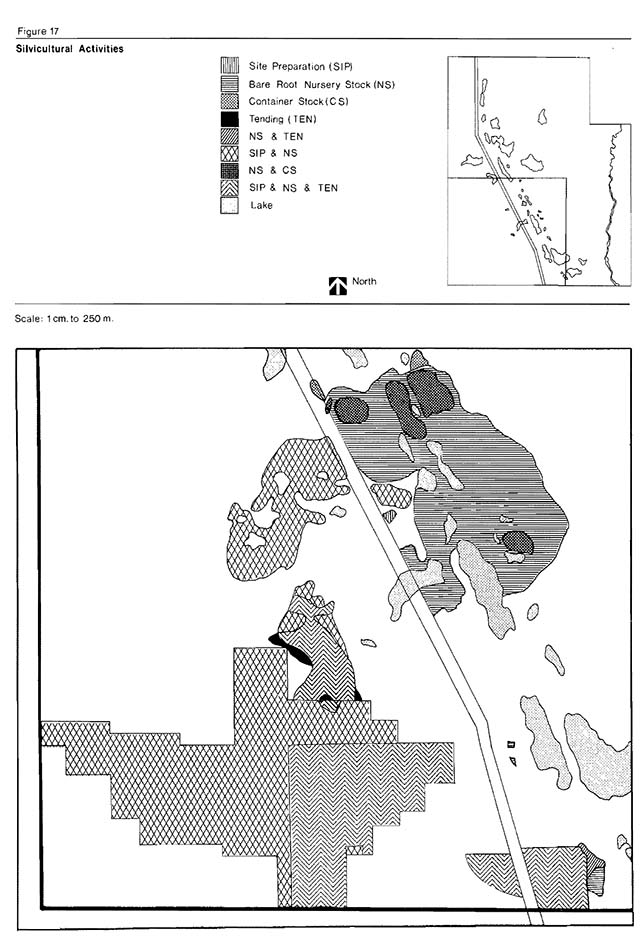
Enlarge figure 17: Silvicultural activities (PDF)
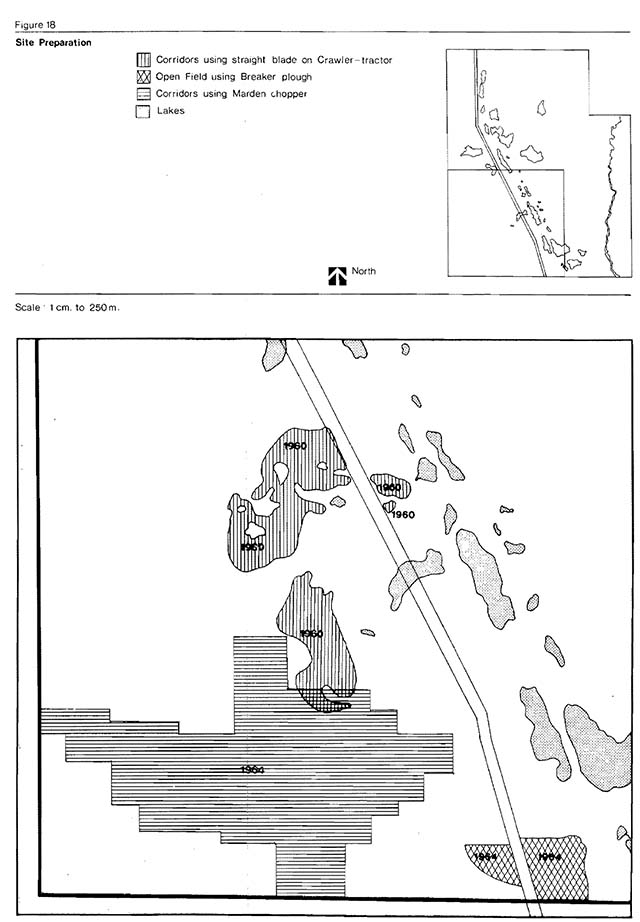
Enlarge figure 18: Site preparation (PDF)
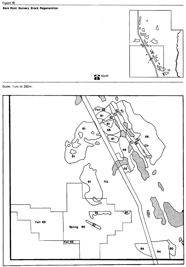
Enlarge figure 19: Regional setting (PDF)
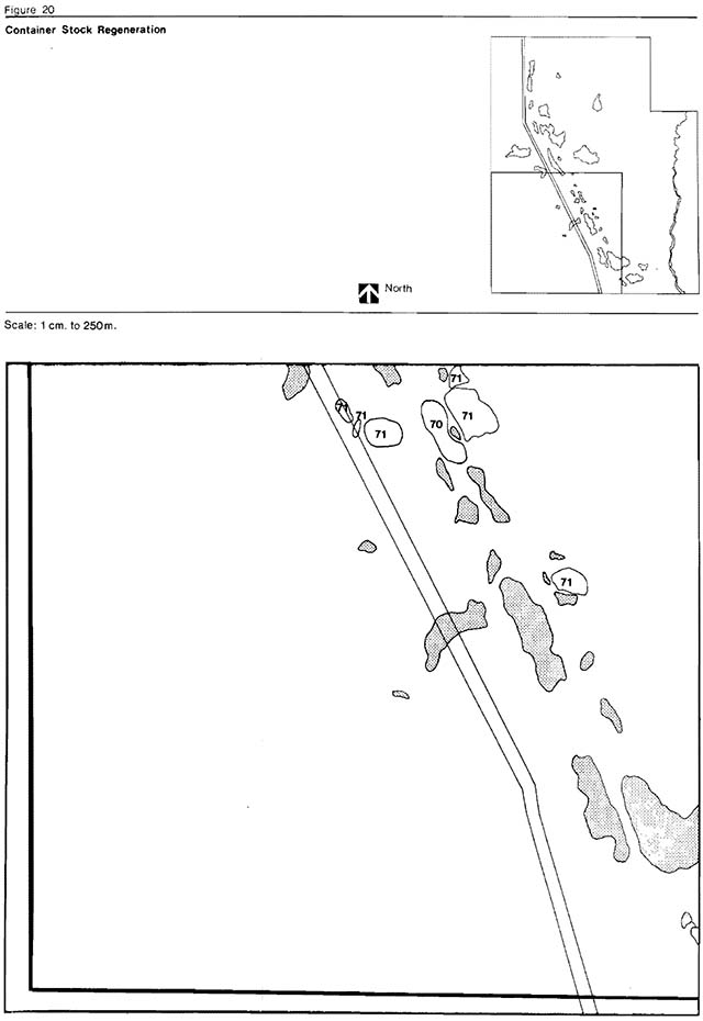
Enlarge figure 20: Regional setting (PDF)
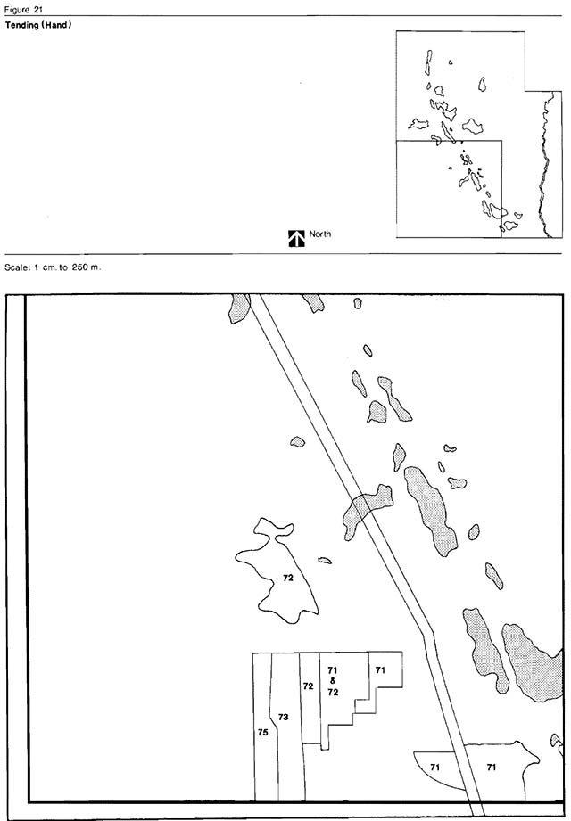
Enlarge figure 21: Regional setting (PDF)
Appendix 5: Carrying capacities
Table A - Existing day-use beach capacity
| Day-Use Beach | Length | Width | m2 | Instantaneous Capacity | Daily Capacity | Seasonal Capacity |
|---|---|---|---|---|---|---|
| Dry Beach | 186 m | 30 m | 558 m2 | 23 | 17 | 1,054 user-days |
| Wet Beach | 186 m | 30 m | 558 m2 | 23 | 23 | 1,426 user-days |
- Average Number of People/m2 = 0.0425 persons/m2
- Turnover Rate = 1.5 dry beach; 2.5 wet beach
- K Factor = 0.5 dry beach; 0.4 wet beach
- Season (July/August) = 62 days
Carrying capacity formula*
Bathing (Wet Beach)
- Instantaneous Daily Capacity = Area of wet beach × average number of people ÷m2 of wet beach
- Theoretical Daily Capacity = Instantaneous daily capacity × turnover × K factor
- Theoretical Seasonal Capacity = Theoretical daily capacity × length of season
Bathing (Dry Beach)
- Instantaneous Daily Capacity = Area of dry beach× average number of people÷m2 of dry beach
- Theoretical Daily Capacity = Instantaneous daily capacity × turnover × K Factor
- Theoretical Seasonal Capacity = Theoretical daily capacity × length of season
*Ontario Ministry of Natural Resources, Ontario Provincial Parks Landscape Design Principles and Guidelines, Park Planning Branch, 1977.
Table B - Picnicking capacity
- Area = 1.2 ha
- Number of Tables = 41
- Average Number of People/table = 5
- Turnover Rate = 1.5
- K Factor = 0.6
- Season = 62 days
Existing capacity
Instantaneous Daily Capacity
= Average number of peoples/table × number of tables
= 5 × 41
= 205 users
**Theoretical Daily Capacity
= Instantaneous daily capacity × turnover rate × K Factor
= 205 × 1.5 × 0.6
= 185 users
Theoretical Annual Capacity
= Theoretical daily capacity K Factor length of season - 185 × 62
= 11,470
**Ontario Ministry of Natural Resources, A Method of Calculating Carrying Capacity, Potential Attractiveness and Management Input of a Site for Varied Use, Research Report #94, Forest Research Branch, Division of Forests.
Table C - Camping: User capacities
Current campground development
Given conditions:
- 107 campsites
- 60 percent occupancy rate
- 62 day peak season (July/August)
- 3.3 persons/campsite
Formula:
Number of campsites × length of season × average number of persons/campsite × 60 percent campsite occupancy
= optimum number of camper-days 107 × 62 × 3.3 × 0.6
= 13,135 camper-days for July/August
Proposed campground expansion
Present number of campsites = 107
Proposed additional numper of campsites = 100
Total number of campsites = 207
Optimum number of camper-days = 207 × 62 × 3.3 × 0.6
Total= 25,411
Appendix 6: Development alternatives and recommendations
The areas described were evaluated based on aerial photo interpretation, first hand experience, and in some cases a brief field re-evaluation. Approximately 10 campsites per ha was used as a measurement guide.
Area A
Description
- Approximately 6.9 ha in size
- Has been previously designated for campsite expansion
- Has a potential for a maximum of approximately 50 sites.
Recommendations
- Develop for camping in Phase to approximtely 50 sites.
Area B
Description
- Approximately 2.7 ha in size
- Has a potential for a maximum of 20 sites in linear development
- Preliminary self-guiding trail under construction
- Lake has low use capability
Recommendations
- No campsite development
- Utilize as a buffer area and develop self-guiding trail.
Area C
Description
- Is approximately 6.9 ha in size
- Maximum potential development 50 sites
- Preliminary self-guiding trail under construction
Recommendations
- No campsite development
Area D
Description
- Develop as a group camping area for approximately 100 users per day
- Its isolated location supports this recommendation Description - Is approximately 8.9 ha in size
- Maximum potential development of 80 sites
- Very minor development presently on Lloyd Lake (4 sites)
Recommendation
- Develop for camping in Phase II and III (25 and 25 sites)
Area E
Description
- Is approximately 3.6 ha in size
- Presently contains Junior Ranger camp
- Has a potential maximum development of 25 sites
Recommendations
- Phase out Junior Ranger camp and utilize some buildings Development of a concession building in Phase II.
Area F
Description
- Approximately 3.8 ha in size
- High land with good campsite potential
- Adjacent to Park Lake campgrounds
Recommendation
- Use for expansion and/or re-development of Park Lake area.
Area G
Description
- Approximately 3.7 ha in size
- Presently encompasses 1.2 ha Green Lake day-use area 35
Recommendation
- Expanded day-use area (Green Lake Day-Use Proposal, Ladoucer and Flood, 1976)
Area H
Description
- Approximately 2.0 ha in size
- Presently has a general information map displayed
Recommendation
- Development as an interpretive complex
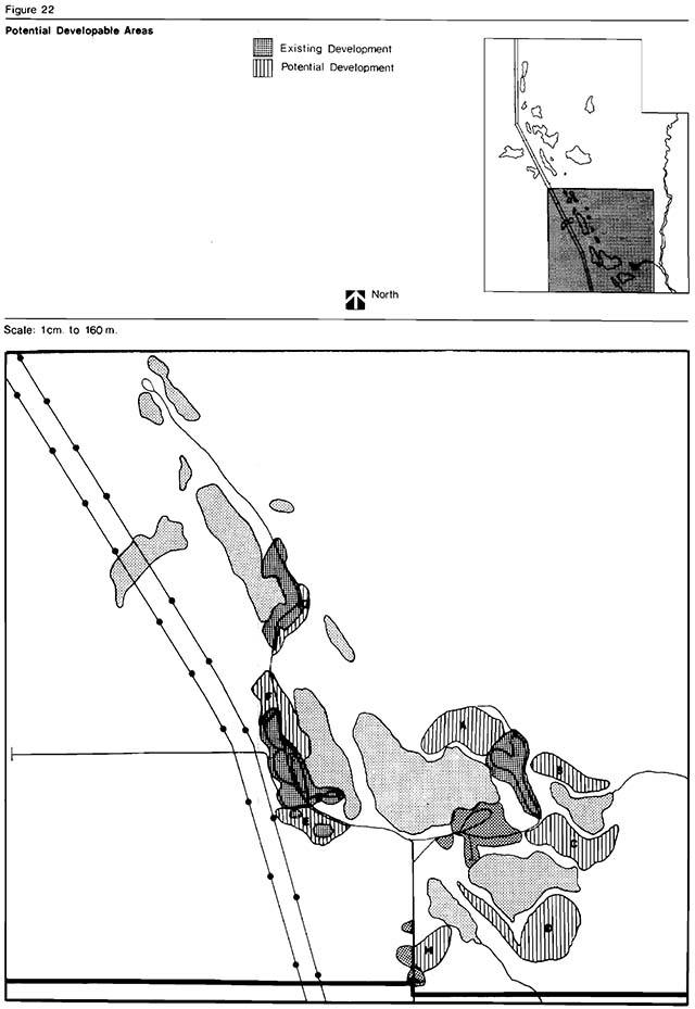
Enlarge figure 22: Potential developable areas (PDF)
Table 12: Rating development area
| Area | Service*1Expansion | Shoreline Rating | Backshore Rating | Impact on Area*2 | Impact on Suitability for camping*3 | Impact on Suitability for other uses | Construction Costs | Recommendations |
|---|---|---|---|---|---|---|---|---|
| Area A | 2 | 2 | 2 | 4 | 1 | 4 | 2 | Develop for camping |
| Area B | 2 | 3 | 3 | 2 | 3 | 1 | 2 | Reserve as a buffer area |
| Area C | 2 | 2 | 2 | 2 | 2 | 1 | 2 | Develop for group camping |
| Area D | 4 | 2 | 2 | 4 | 1 | 4 | 1 | Develop for camping |
| Area E | 1 | 4 | 2 | 3 | 3 | 1 | 3 | Develop for Concession |
| Area F | 1 | 3 | 3 | 3 | 2 | 3 | 1 | Use for expansion in re-development of Park Lake |
| Area G | 1 | 2 | 2 | 3 | 4 | 1 | 2 | Use for expansion in re-development of Green Lake |
| Area H | 1 | 4 | 2 | 2 | 4 | 1 | 3 | Use of interpretive area (amphitheatre panels, etc.) |
*distance from services (i.e. water, electrical, etc.)
*Other uses, soil, etc.
*3 at 10 campsites/hectare
Rating index
1 - High (good)
2 - Medium
3 - Low
4 - Nil (poor)
Appendix 7: Public participation program
At the commencement of the master planning exercise for Greenwater Provincial Park, a news release was prepared by the district and mailed to local papers. It was placed in the Northland Post, the local Cochrane newspaper. This notice advised Cochrane and area residents that a master plan was to be prepared for Greenwater Provincial Park and requested public information or comments pertaining to the park. Upon completion of the preliminary master plan (August, 1978) the Minister of Natural Resources released the plan for public review on August 2, 1978. In his statement, the Minister indicated that copies of the preliminary plan were available on request from the Division of Parks, Queen’s Park, Toronto, and from the District Manager, Cochrane District. Comments on the preliminary master plan were received by the District Manager, Cochrane District up to October 1, 1978.
During the public review period, the plan received coverage by the local media, the Northland Post (Cochrane), Radio Station CKGB (Timmins) and Cable T.V. (Cochrane).
In total, the District Manager received 13 written submissions and numerous verbal comments which were generally supportive of the objectives, zoning and management strategies for the park.
A recommendation by many Park users that small electric motors be permitted in the park is being seriously evaluated and could result in the amendment of the Regulation under the Provincial Parks Act to allow for their use.
Following public input, the plan was submitted to the Minister of Natural Resources in 1979 for review and approval.
Glossary
- Archean:
- older term, approximately corresponding to the Early Precambrian (q.v.)
- Association:
- a more detailed unit of a complex based on a variation in the proportion and dominance of the tree canopy species, ground flora and understory composition and sp~cialized sites hiking, canoeing, etc. in relatively inaccessible areas usually resulting in an overnight stay
- Backcountry travel:
- hiking, canoeing, etc. in relatively inaccessible areas usually resulting in an overnight stay
- Bedding features:
- the combination of strata orientation, thickness, extent, and composition that enable interpretation of their origin “before present”; standard reference used when citing carbon-14 dates to indicate that the date is calculated from the year 1950
- B. P.:
- “before present”; standard reference used when citing carbon-14 dates to indicate that the date is calculated from the year 1950
- Camper-days:
- is defined as one camper staying in a Provincial Park for one night is the number of fish caught and kept per man hour of fishing
- Catch per unit effort (C.U.E.):
- is the number of fish caught and kept per man hour of fishing
- Clear cutting:
- a method of cutting that removes all merchantable trees on the area in the cut a clay till deposited during a shortlived Late Wisconsinan re-advance of the receding continental ice sheet sites exhibiting colder-than-normal microclimates are the broad depressions or flats with cold air drainage, low relief and ground water saturation pertaining to unconsolidated sediments deposited by mass-wasting (collapse and gravity)
- Cochrane Till:
- a clay till deposited during a shortlived Late Wisconsinan re-advance of the receding continental ice
- Colder-than-normal microclimate:
- sites exhibiting colder-than-normal microclimates are the broad depressions or flats with cold air drainage, low relief and ground water saturation
- Colluvial:
- pertaining to unconsolidated sediments deposited by mass-wasting (collapse and gravity)
- Complex:
- is a uniform vegetation unit based on a similarity in substrate, topography and aspect, structure and composition of the tree canopy
- Creel census:
- is a survey (interview) of anglers where data allowing estimates of fishing pressure, catch rate (C.U.E.) and harvest is collected
- Deltai bedding:
- arrangement of stratified sediments consisting of nearly flat bedding overlying steeply sloping strata; strata deposited by low-gradient streams entering a steep-walled basin
- Destination camper:
- a camper who plans his visit to a specific Provincial Park for an extended period of time
- Disconformable contact:
- a discontinuity in parallel strata marked by an irregular surface; indicative of an erosional interval on period of nondeposition
- Dry-beach:
- from the high water mark back to the vegetation line
- Early Precambrian (Period):
- oldest subdivision of the Precambrian (Era); processes and rocks formed more than 2.5 billion years ago
- Eutrophic lakes:
- lakes that are relatively shallow and rich in organic matter and nutrients. They are seasonally deficient in oxygen
- Fluvial:
- pertaining to flowing water processes, deposits, or landforms
- Glaciofluvial:
- pertaining to meltwater streams flowing from glacial ice, their deposits, landforms, et cetera
- Glaciolacustrine varved clays:
- thinly laminated clays composed of alternating layers of light (fine sand, silt) and dark (clay, organic debris) coloured sediments; each pair of laminations is interpreted as an annual deposit accumulated in a proglacial lake
- Instantaneous daily capacity:
- the number of people which an area can accommodate at a specific point in time
- Lacustrine:
- pertaining to, produced by, or formed in a lake
- Lake Barlow-Ojibway:
- a Late Wisconsinan proglacial lake that flooded a large area of northeastern Ontario and northwestern Quebec as the Laurentide ice sheet receded northward
- Lake reclamation:
- describes the removal of all fish from an aquatic community (normally the water body contains pest species) and the reintroduction of one or more desirable species
- Late Wisconsinan:
- a subdivision of the Quaternary Period (“Late Wisconsinan Substage”) or its products (“Late Wisconsinan sediments”), from 23,000 years to 8,000 years ago
- Laurentide ice sheet:
- one of the three main components of Wisconsinan continental glaciers; it covered all of eastern Canada
- Lithology:
- description of rocks by their physical characteristics
- Littoral zone:
- a shallow water zone where light penetrates to the bottom allowing rooted plants such as water lillies, sedges and rushes to grow
- Live bait fish:
- are most members of the Cyprinidae family (excluding some species) which are used alive for bait by fishermen
- Low stocked stands:
- insufficient merchantable volume of wood per acre to warrant economic harvesting (e.g.. less than 5 cords per acre)
- Mesotrophic lakes:
- lakes with a moderate amount of dissolved nutrients and organic material
- Microclimate:
- a uniform local climate for a small site or habitat. There are 3 types of microclimates - normal, warmer than- normal and colder-than-normal
- Normal microclimate:
- sites exhibiting a normal microclimate area located on well-drained soils with good air drainage and low relief (i.e. gently rolling plains with local low ridges and depressions)
- Oligotrophic lakes:
- lakes that are relatively poor in nutrient materials and organic life. These are deep, self-contained lakes which often have steep sides
- Optimum carrying capacity:
- a level of use which is environmentally sound and which is normally less than the maximum possible level of use
- Outwash deposits:
- stratified sediments removed from glacial ice by meltwater and deposited away from the ice sheet
- Paleozoic:
- subdivision of geological time following the Precambrian (“Paleozoic Era”) or on its products (“Paleozoic limestone” ), from 600 million years to 230 million years ago
- Pegmatitic:
- coarse textured (crystal size l cm) igneous rock, commonly associated with and of similar composition to granitic rocks
- Plutonic:
- rock that crystallized from molten material (magma) at great depth beneath the earth’s surface
- Precambrian:
- the oldest subdivision of geological time (“Precambrian Era”) or the geological processes and products of that time interval (Precambrian granite); the Precambrian Era spans over 90 percent of geological time, ending approximately 600 million years ago, and its rocks are characterized by their nearly complete absence of evidence of organic life
- Proglacial:
- in front of or near the outer limits of a glacier
- Put and delayed take fishery:
- Quaternary:
- describes the situation where fish that are too small to catch by angling are stocked in a water body and allowed to grow to a size that fishermen can harvest youngest subdivision bf geological time (“Quaternary Period”) or its products (“Quaternary glaciations”), from 2 million years ago to the present
- Recent:
- the youngest subdivision of the Quaternary Period (“Recent Stage”) or its products (“Recent sediments” ); presently active processes or their products
- Selective cutting:
- the removal of selected mature, large or diseased trees as single scattered trees or in small groups of trees. The result of this type of cutting is an uneven-aged forest
- Silviculture:
- the art and science of cultivating forest crops (e.g. a system of harvesting the timber by clearcutti ng or modified cutting, site preparation, planting and tending)
- Site preparation:
- the removal of logging debris and/or competition (such as older, willow, etcetera) to facilitate either the planting of nursery stock, container stock or the application of seed directly to the microsite (e.g. crawler tractor equipped with a V-blade operating in parallel corridors)
- Site Region 3E:
- a region defined in G. A. Hills’ land classification system (1959). Greenwater Provincial Park is contained in this site region
- Stag spruce swamp:
- a wetland with black spruce which will never attain merchantable size
- Stopover camper:
- a camper who stops overnight while enroute to another destination point
- Stratigraphic:
- pertaining to the arrangement of rock units, particularly their chronological order of sequence relative to each other
- Theoretical daily capacity:
- the total possible use which an area. can sustain or can accommodate in a day
- Theoretical site-types:
- subdivisions of each site region which combine the factors of microclimate, soil texture and moisture regime to produce distinctive vegetation complexes and associations
- Thennocline:
- a layer in a thermally stratified body of water that separates an upper warmer, lighter, oxygen-rich zone from a lower colder, heavier oxygen-poor zone. It is here that the temperature drops most rapidly (-1 C for each meter of depth)
- Warmer-than-normal microclimate:
- sites exhibiting a warmer-than-normal microclimate are moderately elevated masses (esker ridges, drumlins) with excessively drained soils, moderate relief, northeast and southwest facing aspect and good air drainage
- Wet beach:
- the distance from the high water mark to the five foot depth mark
References
Baldwin, W.K.W. Plants of the Clay Belt of Northern Ontario and Quebec. National Museum of Canada, Bulletin No. 156, 1958.
Boissoneau, A.H. Algoma-Cochrane. Surficial Geology: Ontario Department of Lands and Forests Map 5465, Scale 1:508,880, 1965.
___________, Glacial History of Northeastern Ontario.I. The Cochrane Hearst area. Canadian Journal Earth Sciences, v. 3, p. 559-578, 1966.
Chapman, L.J. and M.K. Thomas. The Climate of Northern Ontario. Climatological Studies No. 6, Department of Transport, 1968.
Culm, D.L. A Life Science Report on Greenwater Provincial Park. Ontario Division Parks, Environmental Planning Series, 1976.
Dreimanis, A. and P.F. Karrow. Glacial History of the Great Lakes -St. Lawrence Region, The Classification of the Wisconsin an State, and its Correlatives. p. 5-15 in Proc. 24th Int. Geol. Congress, Sect. 12, Quaternary Geology, 226 p., 1972.
Goodwin, A.M. and R.H. Ridler. The.Abitibi Orogenic Belt. p. 1-30 in Baer, A.J., (ed.), Symposium on basins and geosynclines of the Canadian Shield: Geol. Surv. Canada, Paper 70-41, 265 p., 1970.
Harrison, T.G. Moose Management Plan, Cochrane District. Ontario Ministry of Natural Resources, unpublished report, 1973.
Hughes, O.L. Surficial Geology of Smooth Rock - Cochrane District. Preliminary Report, Department of Mines and Technology, 1956.
Hughes, O.L. Surficial Geolo of Smooth Rock - Cochrane District. Ontario (Preliminary Report and Map: Geol. Surv. Canada Paper 55-41, 9 p., 1956.
Karlstrom, T.N.V. The Problem of the Cochrane in Late Pleistocene Chronology. United States Geol. Surv. Bull. 1021-J, p. 303-331, 1956.
Land Use Co-ordination Branch. Lake Planning. Ministry of Natural Resources, 1976.
Ladoucer, L.J. and C. Flood. Day-Use Evaluation - Green Lake - Cochrane District. Ontario Ministry of Natural Resources, unpublished report, 1975.
Maycock, P.F. A preliminary report on the life science systems plan. Interim report presented at the 6th Ontario Provincial Park Planners Meeting, Cochrane, Ontario, February, 1976.
Ministry of Treasury, Economics and Intergovernmental Affairs 1975. Municipal Directory. 1975. Ministry of Natural Resources. Planning Guidelines and Design Standards for the Ontarfo Provincial Parks System. November 1973.
Ministry of Natural Resources. A Method of Calculating Carrying Capacity, Potential Attractiveness and Management Input of a Site for Varied Use. Research Report #94, Forest Research Branch, Division of Forests.
Ontario Department of Lands and Forests. Forest Resources Inventory Report No. 3 of the Cochrane District. Division of Timber Management, 1953.
Ontario Department of Lands and Forests. A history of the Cochrane Forest District. District History Series No. 14, 1964.
Department of Energy, Mines and Resources. Gazeteer of Canada: Ontario. Canadian Permanent Committee on Geographic Names, 1974.
Ontario Ministry of Natural Resources. Technical Analysis of the Natural Resources. Northeastern Planning Region, Strategic Land Use Planning Program, 1976.
Ontario Ministry of Natural Resources. Directory of the Statistics and Data for Unincorporated Communities in the Northern Region. 1975.
Ontario Ministry of Natural Resources. Northeastern Ontario Recreation Survey Report. Northern Region, 1975.
Ontario Ministry of Natural Resources. Northern Region 1975 Resource Analysis - Inventory of Population Centres in the Northern Region.
Pollock, J. Prehistory, Ethnology and Early Settlement Greenwater Park and Cochrane Area. 1975.
Rowe, J.S. Forest Regions of Canada. Department of Environment, Pub. No. 1300, 1972.
Skinner, R.G. guaternary Stratigraphy of the Moose River Basin, Ontario. Geol. Surv. Canada. Bull. 225, 77 p., 1973.
___. Glacial History of Northeastern Ontario. I. The Cochrane - Hearst Area. Canadian Jour. Earth Sciences, v. 3, p. 559-578, 1966.
___. Surficial Geology of Smooth Rock and Iroquois Falls Map Areas, Cochrane District, Ontario. unpublished Ph.D. diss., Univ. Kansas, Lawrence, Kansas, 190 p., 1959.
___. Preliminary Report on Borings through Pleistocene Deposits, Cochrane District, Ontario. Geol. Surv. Canada Paper 61-16, 3 p., 1961.
Stockwell, C.H. Fourth report on structural provinces, orogenies and time classification of rocks of the Canadian Precambrian Shield.
Geological Survey of Canada, 1964. Terasmae, J. and O.L. Hughes. Glacial retreat in the North Bay area. Ontario: Science, v. 131, p. 1444-1446, 1960.
Surficial Geolo of Part of the Cochrane District, Ontario, Canada. p. 535-565 in Wrigt, Jr. H.E. Frey, D.G. eds. International Studies on the Quaternary: Geol. Soc. America Special Paper 84, 565 p. 1965.
Statistics Canada. 1976 Census of Canada. Catalogue #92-804, Queen’s Printer, Ottawa.
Footnotes
- footnote[*] Back to paragraph Canadian Government Office of Tourism, Vacation Travel by Canadians in 1976, CGOT, August 1977 deficiency of these year-round attractions.