Greenwater Provincial Park Management Plan: Amendment
This document provides direction on the management of Greenwater Provincial Park.
Greenwater Provinicial Park
Management Plan - Minor Amendment
2007
Approval statement
I am pleased to approve this Minor Amendment to the Greenwater Provincial Park Management Plan (OMNR 1979). This minor amendment is a statement of policy update to the original 1979 management plan.
This minor amendment is based on direction in Ontario’s Living Legacy Land Use Strategy (OMNR 1999) to add lands identified as Greenwater Provincial Park Addition to Greenwater Provincial Park. The original park management plan and this minor amendment address policies for protection, management, and development of all lands and waters that are now regulated as a part of Greenwater Provincial Park (O. Reg. 180/05). The original park management plan for Greenwater Provincial Park and this minor amendment provide guidance for the resource stewardship, development and operations consistent with park objectives.
Signed by:
Paul Bewick
Zone Manager
Northeast Zone
Ontario Parks
Date: January 3, 2007
1.0 Introduction
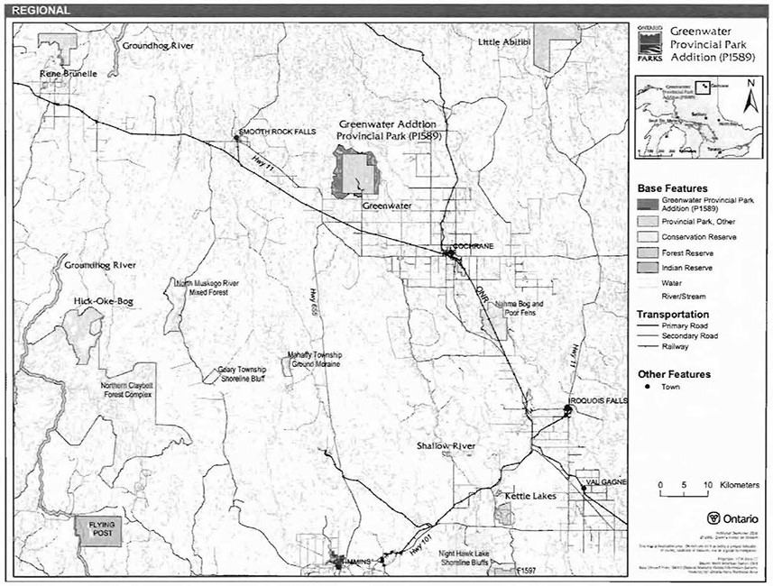
The Greenwater Provincial Park Addition (P1589) is located approximately 34 kilometres to the northwest of Cochrane via Highway 11 and Highway 668 (Figure 1). The original Greenwater Provincial Park was 5,350 hectares in size. The new park addition includes an additional 3,166 hectares which increases the size of the park to 8,516 hectares.
The addition is the same classification as the original park: natural environment. Natural environment parks provide outstanding recreational landscapes which contain representative natural features. The addition will also provide high quality recreational and educational experiences.
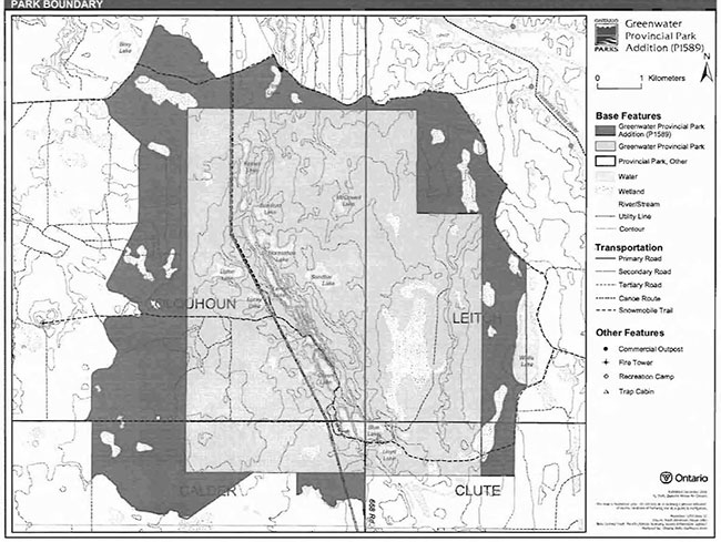
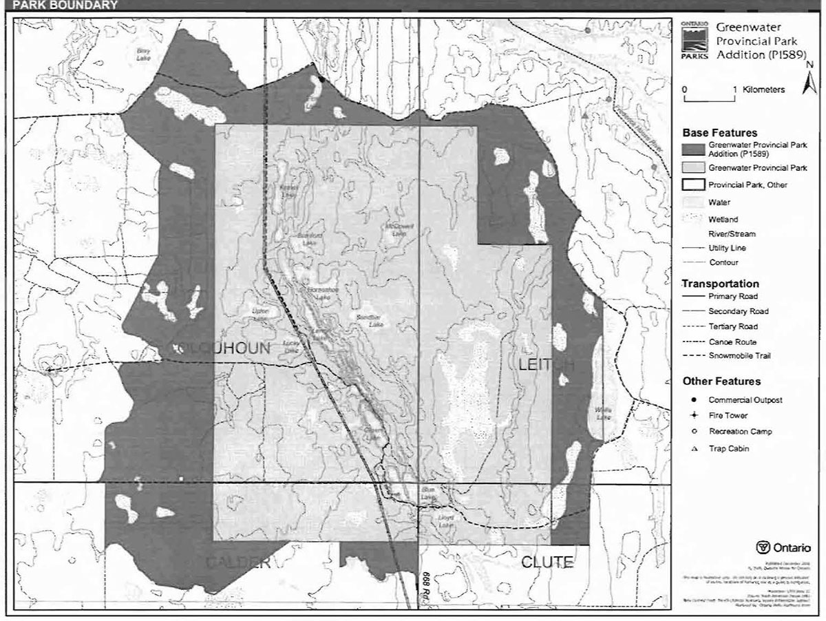
The Greenwater Provincial Park Addition lies within Calder, Clute, Colquhoun, and Leitch townships (Figure 2). The addition to the existing park provides a boundary based on natural features that complement the ecological integrity of Greenwater Provincial Park (OMNR 1999).
Ontario’s Living Legacy Land Use Strategy (OMNR 1999) identified this area as an addition to the existing Greenwater Provincial Park. The strategy changed some provincial policies for existing parks and introduced some different management policies for the new protected areas. These are reflected in this minor amendment.
1.1 Objectives
The Greenwater Provincial Park Addition will be managed according to the four objectives for provincial parks:
Protection: To protect provincially significant elements of the natural and cultural landscapes of Ontario.
Recreation: To provide provincial park outdoor recreation opportunities ranging from high-intensity day-use to low-intensity wilderness experiences.
Heritage Appreciation: To provide opportunities for exploration and appreciation of the outdoor natural and cultural heritage of Ontario.
Tourism: To provide Ontario’s residents and out-of-province visitors with opportunities to discover and experience the distinctive regions of the Province.
2.0 Management context
The purpose of this minor plan amendment is to provide direction to ensure the custodial management of park resources. Future park planning may be undertaken as required to provide direction on significant decisions regarding resource stewardship, development, operations and permitted uses.
Park management will follow policy direction from:
- Provincial Parks Act (1990) and regulations
- Ontario’s Living Legacy Land Use Strategy, policy clarification amendments (OMNR 2000), and related direction
- Ontario Provincial Parks Planning and Management Policies (OMNR 1992a) and updates
- Crown Land Use Policy Atlas (OMNR 2004a) and amendments.
Figure 1: Regional setting
Enlarge map for Regional setting
Figure 2: Park boundary
In addressing custodial management obligations to protect park values and ensure public health and safety, Ontario Parks will ensure that policy and Environmental Assessment Act (1990) requirements are implemented.
2.1 Environmental Assessment
As a part of the Ontario Ministry of Natural Resources (MNR), Ontario Parks is a public sector agency which is subject to the Environmental Assessment Act. Park management will be carried out in accordance with legislation, policies, and guidelines that are required under A Class Environmental Assessment for Provincial Parks and Conservation Reserves (OMNR 2005).
3.0 Park features and values
3.1 Geological features
Greenwater Provincial Park Addition is in ecodistrict 3E-1 (Smokey Falls) of the Lake Abitibi ecoregion. Ecodistrict 3E-1 is characterized by a smooth plain of clay and loam, moderate to high in lime, shallow to moderately deep over bedrock with extensive areas of muskeg. The quaternary geology coverage shows this site to be composed largely of till.
A larger section of glaciofluvial ice-contact deposits adjacent to glaciolacustrine deposits runs through the center of Greenwater Provincial Park and the northern section of the addition. The section of glaciofluvial ice-contact deposits and glaciolacustrine deposits are an esker system which was deposited prior to the Cochrane ice sheet re-advance. The clay till overlaid sand and gravel of the esker system and sills were deposited adjacent to the esker. Other areas of the park addition contain clay silty till with a discontinuous veneer of peat overlaying it. In the southwest corner of the addition, there is a small outcrop of bedrock of granitic rock, which is common in the Precambrian Shield (Cudmore, King, and Longyear 2004).
3.2 Biological features
The Greenwater Provincial Park Addition is located within the Boreal Forest. The addition is also within the Clay Belt, which is characterized by black spruce stands covering gently rising uplands and as lowland flats. There are extensive areas of spruce-cedar swamp, especially in the western section of the park addition. The southern section contains fine hardwood and mixedwood stands of trembling aspen, balsam poplar, balsam fir, white spruce, and black spruce. Some white birch can be found in the eastern and south western sections of the addition.
There are six harvested areas within the Greenwater Provincial Park Addition. These areas have been harvested as recently as 1998 to 1999, and as far back as the 1970s. Older cut areas have been replanted prior to park establishment. More recent cut areas were not planted.
The two largest lakes in the park addition are Wolfe and Fink lakes. Wolfe Lake is the larger of the two and is located on the eastern side of the park. A portion of Wolfe Lake is outside of the park addition area. Fink Lake is located in the northern section of the park. Both lakes are situated beside primary access roads. Deception Creek, located along the eastern boundary of the addition, contains a natural brook trout population. The creek is the closest cold water fishery to the town of Cochrane (Stewart 2001).
3.3 Cultural setting
An investigation into the cultural features of the Greenwater Provincial Park Addition has not yet been completed; however, an investigation of the development of the Great Claybelt Farming Areas in relation to Greenwater Provincial Park has been conducted. This report covers the early farming activities in the townships in and around the original provincial park (Dodds 1978). This report describes some of the areas in the Greenwater Provincial Park Addition. In the early part of the twentieth century, people settled the area in order to take advantage of the fertile soil of the Claybelt. Parts of Colquhoun and Calder townships were settled with the intent to farm, but most people found that the land was too hard to clear. Instead, many people sold the wood on their lot as pulp to a local mill and then moved south. A few years later, when it became obvious that roads would not be extended beyond the village of Hunta, the remaining settlers abandoned their lands. Today, there are no farms in Colquhoun township. The park addition may contain a remnant school house that once served the area. Until a full investigation of the cultural features of the park addition is undertaken, the extent to which the addition was settled will not be known for certain.
Any future planning will be within the context of a provincial framework, A Topical Organization of Ontario History (OMNR 1974). In addition, updates and discussions with First Nations and other agencies and stakeholders may be carried out to identify cultural heritage values and features within the park and their significance. This information may be used to develop management guidelines to conserve and protect representative archaeological and historical values and features, or to provide direction for further research.
3.4 Recreation
The Greenwater Provincial Park Addition can support a wide variety of outdoor recreation opportunities including, canoeing, fishing, boating, hunting, mountain biking, backcountry camping, and nature exploration. In addition, all-terrain vehicle (ATV) use may occur on roads that have been designated by the superintendent. Future management planning will review all uses, including ATV use, in order to ensure that park features and values are protected and to assess the potential for ATV use to conflict with other uses.
4.0 Aboriginal uses
The Greenwater Provincial Park Addition is located within the 1905 AE treaty boundary. The nearest First Nation, Taykwa Tagamou Nation, is located approximately 50 kilometres to the southeast.
First Nations have expressed interest in and have shared knowledge of the park and surrounding area. Aboriginal communities have used the area for hunting, trapping, fishing, gathering and travel. These uses may continue, subject to public safety, conservation and other considerations.
Any communications and cooperation between Aboriginal communities and the MNR for planning and operations purposes will be done without prejudice to any future discussions or negotiations between the government of Ontario and Aboriginal communities.
5.0 Stewardship policies
Non-native species will not be deliberately introduced into the park. Where non-native species are already established and threaten park values (i.e., has become invasive), a strategy to control the species may be developed (OMNR 1992).
5.1 Terrestrial ecosystems
The removal, damage or defacing of Crown properties, natural objects, relics and artifacts is not permitted in provincial parks (Provincial Parks Act).
5.1.1 Vegetation
Harvesting
Commercial forest operations are not permitted within the park (OMNR 1992).
The harvest of non-timber forest products such as club moss, Canada yew, etc., will not be permitted within the park (OMNR 1992).
Existing authorized wild rice harvesting may continue. New operations will not be permitted.
There are no fuelwood cutting permits currently issued for the park. New permits will not be issued (OMNR 2000).
Insects and disease
Insects and diseases may be managed where the aesthetic, cultural, or natural values of the park are threatened (OMNR 1992). Control measures will follow guidelines established by the Ontario Ministry of the Environment (MOE) and MNR. Whenever possible, biological control measures will be given preference over the use of chemicals (OMNR 1992).
Fire
Greenwater Provincial Park Addition is located within MNR's Boreal Fire Management Zone. In accordance with existing provincial park policy and the Forest Fire Management Strategy for Ontario, forest fire protection will be carried out in the park as on surrounding lands (OMNR 2004b). Whenever feasible, MNR's Forest Fire Management program will use techniques that minimize damage to the landscape, such as limiting the use of heavy equipment or limiting the number of trees felled during response efforts (OMNR 2004b).
5.1.2 Wildlife Management
Greenwater Provincial Park Addition is located within Wildlife Management Unit 27. The removal or harassment of non-game animals is not permitted (Provincial Parks Act).
Hunting
Sport hunting is permitted to continue within Greenwater Provincial Park Addition (OMNR 1999). Considerations of safety and conservation with respect to hunting may be made through future management planning, which would include public and Aboriginal consultation (OMNR 2000).
The Fish and Wildlife Conservation Act (1997), as well as the Migratory Birds Convention Act (1994), govern hunting within the park addition. The Ontario Hunting Regulations Summary contains regulations specific to this area. The harvest of bullfrogs and snapping turtles is illegal in provincial parks.
Hunting is not permitted in the original Greenwater Provincial Park.
Bear Management Areas
There are no existing Bear Management Areas (BMA) in the Greenwater Provincial Park Addition.
New BMA licences will not be permitted (OMNR 2000; 2003).
Trapping
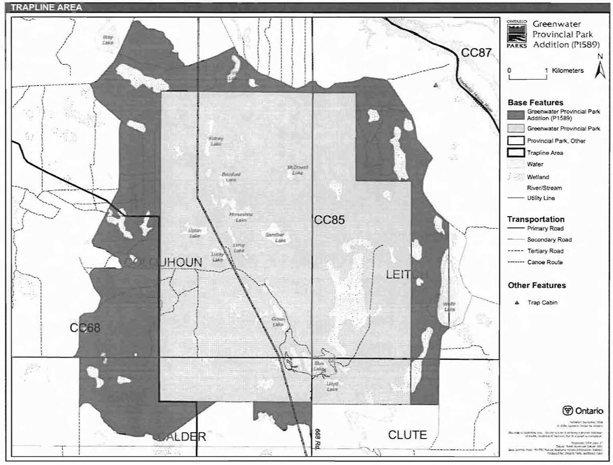
There are portions of two existing trap line areas in Greenwater Provincial Park Addition: CC85 and CC68 (Figure 3).
Existing commercial fur harvesting operations may continue where the activity has been licensed or permitted since January 1, 1992. New operations, including trap cabins and trails, will not be permitted (OMNR 2000; 2003).
Transfers of active trap line licenses are permitted, subject to a review of potential impacts, and the normal types of transfer situations.
Figure 3: Trap line areas

Enlarge map for Trap line areas
5.1.3 Industrial resources
There are no existing mining claims within park. The mining and surface rights on all lands within the park have been withdrawn from staking under the Mining Act (1990). Mineral exploration and mining are not permitted in the park.
As outlined in the Ontario’s Living Legacy Land Use Strategy, commercial timber harvesting and hydro development are not permitted in the Greenwater Provincial Park Addition.
5.1.4 Access and crossings
Access
The Greenwater Provincial Park Addition is accessible by primary, secondary, and tertiary roads, as well as by snowmobile during the winter. Canoe access exists at Deception Creek.
Roads
The park addition can be accessed by road in three ways: a secondary road along the northwestern boundary, primary roads from the south which run along the eastern boundary, and a primary road which enters the existing park from the south.
Where existing forest access roads are essential for continued access beyond the park for forest management or recreation purposes, and alternative road access does not exist, or road relocation is not feasible, existing roads will continue to be available for access. Continued use will include maintenance and may include upgrades (OMNR 2004a). Ontario Parks is not responsible for the maintenance or upgrade of any roads within the park boundary.
Any proposed development, maintenance or upgrading of existing roads must meet all Environmental Assessment Act requirements.
Utility corridors
A utility corridor runs north and south through the Greenwater Provincial Park Addition.
All public utilities (e.g. gas pipelines, transmission lines, communications towers) must avoid park lands wherever possible. New utility corridor crossings may be necessary to maintain essential public services (OMNR 2004a).
Any future utility corridors proposed through the park, where park lands are unavoidable, will be reviewed on a case-by-case basis. Protection of park features and values will be priority and all requirements of the Environmental Assessment Act will be met.
Recreational trails
Snowmobile Trails: Some tertiary roads and trails within the park addition are used by the Ontario Federation of Snowmobile Clubs (Stewart 2001). A main trail running between Cochrane and Smooth Rock Falls travels through the northwestern part of the addition and then along the northern and eastern boundaries. Sections of snowmobile trail also travel through other parts of the addition, as well as the existing provincial park.
All-Terrain Vehicle Trails: At the time of regulation of the addition, there were no authorized ATV trails within the addition. ATV use may be authorized on old forest access and tertiary roads; this use will be reviewed during future park management planning.
Hiking Trails: There are no designated hiking trails within the park addition. New trails may be developed if the need arises. Any proposed development within the park is subject to Environmental Assessment Act requirements.
5.1.5 Adjacent land management
Forestry
The lands adjacent to the Greenwater Provincial Park Addition are located in the Smooth Rock Falls Forest Management Unit in the northwest and the Cochrane Moose River Management Unit in all other surrounding lands. The Smooth Rock Falls Forest Management Plan was renewed in 2005 and the Cochrane Moose River Management plan was renewed in 2003.
Provincial parks
The nearest park to the Greenwater Provincial Park Additions, apart from the existing Greenwater Provincial park, is the Groundhog River Provincial Park (P1569), which is located approximately 20 kilometres to the west. This waterway provincial park is a 13,960 hectare linear park which flows northward (OMNR 2004a). Other parks in the area include Rene Brunelle, Kettle Lakes, Hick-Oke Bog and Little Abitibi.
Conservation reserves
The nearest conservation reserve (CR) to the Greenwater Provincial Park Addition is the Nahma Bog and Poor Fens CR, which is located approximately 40 kilometres from the park addition, just south of the town of Cochrane. There are three other conservation reserves in the greater area. They are the North Muskego River Mixed Forest CR, the Mahaffy Township Ground Moraine CR, the Geary Township Shoreline Bluff CR, the Northern Claybelt Forest Complex CR. and the Night Hawk Lake Shoreline Bluffs CR.
General use area
There are three general use areas adjacent to the park: Critical Aggregate Areas (Cochrane), Great Claybelt Agricultural Areas, and the Southern Resource Area.
The Critical Aggregates Areas (G1749) includes several high quality aggregate areas. One of these areas is adjacent to southern boundary of Greenwater Provincial Park and the park addition. The land use intent for these areas is the protection and utilization of aggregate resources.
The Great Claybelt Agricultural Areas (G1760) includes critical agricultural areas along the Highway 11 corridor. Land adjacent to the southern boundary of the park and the park addition is within the Great Claybelt Agricultural Area. The land use of this area is the protection and use of Class 3 and 4 agricultural areas for agricultural purposes.
The Southern Resource Area (G1745) surrounds the Greenwater Provincial Park Addition on all sides, except for those that are adjacent to the above general use areas. The land use priority to this area is forest management and mineral exploration and development.
5.1.6 Land disposition
New land disposition for the private use of individuals or corporations will not be permitted (OMNR 1992; 2000).
Land use permits, licenses of occupation, unauthorized occupations
There is one existing land use permit (LUP) in the Greenwater Provincial Park Addition. The permit is for a commercial outpost camp on Fink Lake.
Existing authorized LUPs may be eligible for enhanced tenure but not the purchase of land. Recreational camp LUPs cannot be changed to commercial LUPs unless this is supported during a review as part of park management planning. Enhanced tenure is defined as a possible extension of the term of the LUP for up to 10 years or upgrade in tenure (i.e. LUP to lease) (OMNR 2000a).
Enhanced tenure for an LUP is not guaranteed. Requests for enhanced tenure or to transfer LUPs will be reviewed based upon the following criteria:
- Continued compliance with the conditions of the LUPs
- Current land disposition policies for LUPs
- Consistency with park objectives to sustain values - no effects on heritage values and/or conflict with other uses
- Consistency with Aboriginal land claim negotiations or protocol agreements
- All rents, taxes, fees, rates, or charges are paid and in good standing.
An extension in the term of tenure for an existing LUP does not convey a commitment to provide for a change in the type or the standard of existing access to the Commercial Outpost camp.
Patent land
One parcel of patent land, which is completely surrounded by park land, occurs in the western portion of the Greenwater Provincial Park. Patent land is not included within the park boundary and as such park policy does not apply to this area.
Boat caches
There are no boat caches in the Greenwater Provincial Park Addition.
Boats are not permitted to be left unattended in the park without written permission from the superintendent under the authority of the Provincial Parks Act.
5.2 Aquatic ecosystems
Sustaining quality water resources is integral to the protection of park and adjacent land values. The MOE enforces applicable legislation and regulations for water quality.
5.2.1 Water management
New hydroelectric developments are not permitted within Greenwater Provincial Park Addition (OMNR 1992b; 1999).
5.2.2 Fisheries management
Fisheries management will complement the maintenance and enhancement of native, selfsustaining fish populations (OMNR 1992).
Sport fishing
Sport fishing is permitted within the park. This activity is governed by legislation and regulations in the Fish and Wildlife Conservation Act and the Fisheries Act (1985). The Recreational Fishing Regulations Summary contains details on regulations which are applicable to this area.
Commercial fishing
There are no commercial fishing operations within the boundary of the Greenwater Provincial Park Addition. New operations will not be permitted (OMNR 2004a).
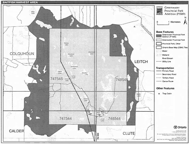
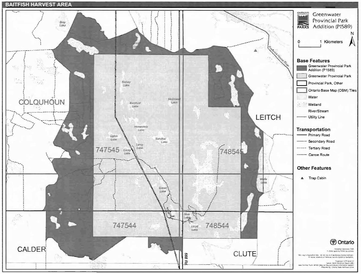
Commercial baitfish harvesting
There are three baitfish allocations in the Greenwater Provincial Park Addition. They are in Leitch, Clute, Colquhoun and Calder townships and are allocated according to OBM number (48544, 48545, 47544) (Figure 4).
Existing commercial baitfish harvesting may continue where the activity has been licensed or permitted since January 1, 1992. This activity may be subject to conditions identified through future park management planning or fisheries management plans. New baitfish licenses will not be permitted (OMNR 2000; 2003).
Fish stocking
The stocking of native fish species may be considered through park management planning, with full public and Aboriginal consultation. Non-native fish species will not be deliberately introduced into park waters (OMNR 1992).
6.0 Operations policies
6.1 Recreation management
6.1.1 Motorized recreation
Motorboats
The use of motorboats is permitted to continue, unless park values are being threatened (OMNR 2004a).
Aircraft
All aircraft landings are subject to regulation and valid aircraft landing permits issued by the park superintendent under the authority of the Provincial Parks Act.
Snowmobiles
Proposals for new trails may only be considered through future planning with public and Aboriginal consultation (OMNR 2000). Snowmobile use on existing routes for access to private land in-holdings, LUPs, and recreational ice fishing may continue unless park values are threatened. Snowmobile use may be authorized on old forest access and tertiary roads.
All-Terrain vehicles
Proposals for new trails may only be considered through future planning with public and Aboriginal consultation (OMNR 2000). ATV use may be authorized on old forest access and tertiary roads and the snowmobile trail. ATVs are not authorized off-road or off-trail.
Figure 4: Baitfish harvest areas
Enlarge map for Baitfish harvest area
6.1.2 Non-motorized recreation
Camping
Ontario Parks may assess the condition of existing campsites and will maintain, rehabilitate or close sites as required. If there is an identified need, new campsites may be considered (OMNR 2004a). Infrastructure will be permitted in order to protect park features and values in response to use, environmental deterioration and environmental protection requirements. Any proposed development in the park must fulfill the requirements of the Environmental Assessment Act.
Hiking
There are no existing hiking trails within the Greenwater Provincial Park Addition.
If there is an identified need, the development of new hiking trails may be considered. Trail infrastructure to protect park values and features will be permitted. Any proposed development within the park is subject to Environmental Assessment Act requirements.
Canoeing/kayaking
Existing uses may continue, unless park values are threatened (OMNR 2004a). Infrastructure to protect park features and values may be permitted and developed in response to use, environmental deterioration and environmental protection requirements.
6.1.3 Emerging recreational uses
There are emerging recreational uses for which there is limited policy to deal with their management (e.g. adventure racing, geocaching, etc). The park superintendent will use legislation, policy and guidelines that are in place to manage emerging uses in the interim.
6.2 Development
Infrastructure to protect park features and values may be permitted and developed in response to use, environmental deterioration, and environmental protection requirements. Any proposed development within the park is subject to the Environmental Assessment Act.
6.3 Commercial tourism
Infrastructure for commercial tourism does not exist within the Greenwater Provincial Park Addition. New commercial tourism facilities maybe considered through park planning, which includes public and Aboriginal consultation (OMNR 1999). Any development must meet the requirements of the Environmental Assessment Act.
7.0 Cultural resources
No assessment of cultural resources specific to Greenwater Provincial Park Addition has been completed at this time; however, the management of any cultural values within the park will be directed toward protection and heritage appreciation (OMNR 1992a).
8.0 Heritage education
Literature and other supporting information may be developed to describe the park in the context of Ontario’s provincial park system. Boundary limits, significant heritage features and permitted uses of the waterway park may be included in park literature.
Prospective park visitors may be informed about the sensitivity and significance of park values through park literature.
The major themes of the original Greenwater Provincial Park include the earth science theme of "deglaciation" and the historical themes of the "Ciaybelt", the "North Central Pulp and Paper" and "Modern Ontario". The historical themes are all closely related and refer to the early 20th century settlement history of the park.
9.0 Research
Scientific research by qualified individuals which contributes to the knowledge of natural or cultural history, or to environmental or recreational management, may be encouraged in the park. Ontario Parks will encourage institutions, such as universities, to undertake research projects.
All research programs will require the approval of Ontario Parks and are subject to park policy and other applicable legislation. Any materials removed from the park will remain the property of Ontario Parks.
Approved research activities and facilities will be compatible with the park’s protection objective. Any site which is affected by research will be rehabilitated as closely as possible to its original state. Environmental Assessment Act requirements will apply.
10.0 References
Cudmore, W., L. King and S. Longyear, 2004. Greenwater Provincial Park Addition (P1589): Life Science Checksheet.
Dodds, E.J. 1978. A Historical Review of the Development of the Great Clay Belt Farming Area: With Specific Reference to Greenwater Provincial Park.
Environmental Assessment Act, 1990.
Fish and Wildlife Conservation Act, 1999.
Fisheries Act, 1985.
Migratory Birds Convention Act, 1994.
Mining Act, 1990.
Natural Resources Values Information System, 2004.
Ontario Ministry of Natural Resources, 1974. A Topical Organization of Ontario History. Historic Sites Branch Division of Parks.
Ontario Ministry of Natural Resources, 1992a. Ontario Provincial Parks Planning and Management Policies, 1992 Update.
Ontario Ministry of Natural Resources, 1992b. Greenwater Provincial Park Management Plan.
Ontario Ministry of Natural Resources, 1999. Ontario’s Living Legacy Land Use Strategy. Queen’s Printer for Ontario.
Ontario Ministry of Natural Resources. 2000. Ontario Provincial Park Policy as Amended by the Ontario Living Legacy Land Use Strategy.
Ontario Ministry of Natural Resources, 2004a. Crown Land Use Policy Atlas.
Ontario Ministry of Natural Resources. 2004b. Forest Fire Management Strategy for Ontario. Aviation and Fire Management Branch.
Ontario Ministry of Natural Resources, 2005. A Class Environmental Assessment for Provincial Parks and Conservation Reserves.
Provincial Parks Act, 1990.
Stewart, Robin, 2001. Greenwater Provincial Park Addition - P1589, Recreation Assessment.
Appendix A: Background information
| Name | Greenwater Provincial Park Addition (P1589) |
|---|---|
| Classification | Natural Environment |
| Ecoreglon/Ecodlstrlct | 3E-1 (Smokey Falls) |
| OMNR Administrative Region/District | North East Region - Cochrane |
| Total Area (ha) | 3,166 |
| Regulation Date and Number for Original Park | 1957 (O.Reg. 821/80) |
| Regulation Date and Number for the Addition | April 21, 2005 (O.Reg. 180/05) |
Representation
Earth science:
Greenwater Provincial Park addition is in ecodistrict 3E-1 of the lake Abitibi ecoregion. Ecodistrict 3E-1 is characterized by a smooth plain of clay and loam, moderate to high in lime, shallow to moderately deep over bedrock with a fairly high percentage of muskeg. The quaternary geology coverage shows this site to be composed of largely till. Also, a larger section of glaciofluvial icecontact deposits adjacent to glaciolacustrine deposits runs through the center of the Greenwater Provincial Park and thus runs through the northern section of the addition. The section of glaciofluvial ice-contact deposits and glaciolacustrine deposits are an esker system which was deposited prior to Cochrane re-advance that represents a subglacial conduit and all the sediment was redeposit as till. The clay till overlaid sand and gravel of the esker system and sills were deposited adjacent to the esker. In the other areas of the park addition are represent as clay silty till with a discontinuous veneer of peat overlaying it. In the southwest corner there is a small outcrop of bedrock of granitic rock, which is common in the Precambrian Shield (Wendy, Cudmore and Sean Logyear, 2004).
Life science:
The forest region is located within the 'Clay Belt' which has seemingly endless stretches of stands with black spruce which cover the gently rising uplands as well as the lowland flats, alternative in the latter position with extensive sedge fens and sphagnum-heath bogs. Tamarack is an infrequent companion of the black spruce except in young stands. There are extensive areas of spruce-cedar swamp that occur, especially in the western area of the park. The southern area of the park has fine hardwood or mixed wood stands of trembling aspen, balsam poplar, balsam fir, white spruce and black spruce; which, are present due to the improvement in drainage, due to slight changes in relief to shallowly buried coarse drift or to positions beside rivers and lakes (Wendy, Cudmore and Sean Logyear, 2004).
Cultural resources:
An investigation and analysis of the cultural resources specific to Greenwater Provincial Park Addition has not been completed at this time.
Future planning will use a provincial framework, The Topical Organization of Ontario History (OMNR 1974) and updates and discussions with other agencies, First Nations and interests to identify cultural heritage values and features and their significance within the Greenwater Provincial Park Addition. This information may be used to develop management guidelines to conserve and protect representative archaeological and historical values and features. as well as provide direction for further research.
Recreation and tourism:
Recreational activities are linked to the features found within the site. Present and potential recreational activities found within the site are limited to standard northern Ontario activities. The forest access roads are a popular corridor for locals to hunt moose and ruffed grouse. A tourist establishment exists in the addition on the north shore of Fink Lake. Deception Creek is known to have a natural brook trout population, even though it is the closest natural cold water fishery to the town of Cochrane. it is not used by many anglers. This is probably because it is a well kept secret. Tertiary roads within the site allow for snowmobiling and ATV use. Other potential recreational activities include canoeing along Deception Creek and general nature viewing (Robin Stewart and Melanie Silver, 2001).
Inventories
| Survey Lavel | Earth Science | Life Science | Cultural | Recreational | Other |
|---|---|---|---|---|---|
| Reconnaissance | Required | Cudmore, King and Longyear, 2004 | Required | Stewart Silver, 2001 Harper, 2003 | Required |
Footnotes
- footnote[1] Back to paragraph Transfers include situations where a license is surrendered with a request that it be immediately reissued to another individual that is assuming an existing operation including trap line cabins for the purposes of trapping. If a trap line license is revoked or surrendered, all portions of the registered line within the park will be rescinded from the legal description of the trap line (OMNR 2000).