Groundhog River Provincial Park Management Statement
This document provides direction on the management of Groundhog River Provincial Park.
Interim Management Statement
Ontario 2007
Approval statement
I am pleased to approve this Interim Management Statement for Groundhog River Provincial Park. Ontario’s Living Legacy Land Use Strategy (1999) identified this area as a waterway class provincial park. The Groundhog River Provincial Park was regulated in June of 2006 (O. Reg. 331/06).
This Interim Management Statement provides direction for the protection and custodial management of Groundhog River Provincial Park.
Signed by:
Paul Bewick
Zone manager
Northeast zone
Ontario Parks
Date: February 12, 2007
1.0 Introduction
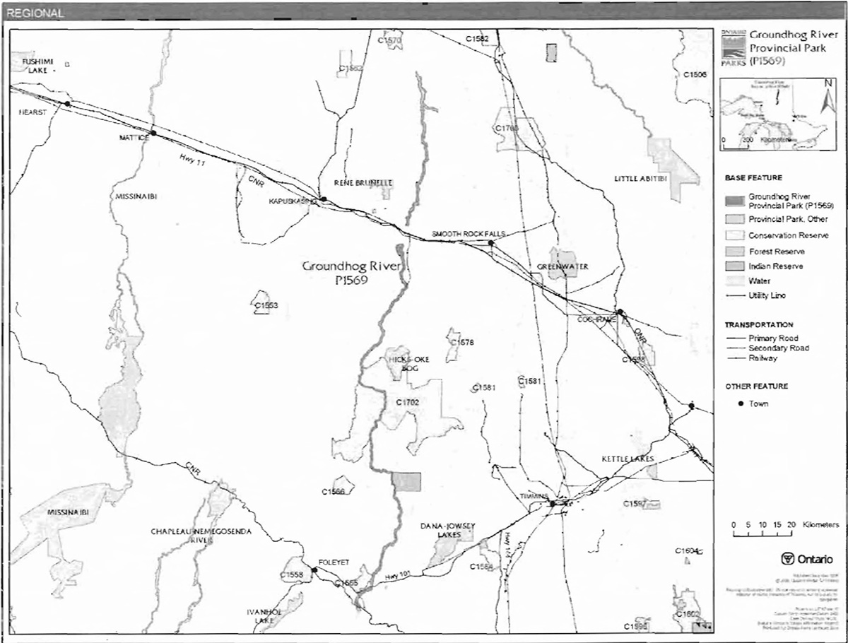
The Groundhog River begins southeast of Foleyet and flows north into the Mattagami River. The southern limit of Groundhog River Provincial Park is located approximately 21 kilometres southeast of the community of Foleyet (Figure 1). The northern most boundary, on the Mattagami River,is located approximately 54 kilometres northeast of the town of Kapuskasing (Figure 2).
The boundary of this waterway class provincial park contains approximately 11,036 hectares of Crown land (O. Reg. 331/06). This did not include all the lands that were identified in Ontario’s Living Legacy Land Use Strategy (OMNR ) 1999. Deferred lands from the original boundary occur upstream and downstream of Fauquer, which may result in additional lands being identified for park purposes in the future. The purpose of the waterway designation is to protect outstanding recreational water routes and to provide high quality recreational and education experiences (OMNR 1992).
1.1 Objectives
The park will be managed based on the four objectives for provincial parks:
Protection: To protect provincially significant elements of the natural and cultural landscapes of Ontario.
Recreation: To provide provincial park outdoor recreation opportunities ranging from highintensity day-use to low-intensity wilderness experiences.
Heritage Appreciation: To provide opportunities for exploration and appreciation of the outdoor natural and cultural heritage of Ontario.
Tourism: To provide Ontario’s residents and out-of-province visitors with opportunities to discover and experience the distinctive regions of the Province.
2.0 Management context
The purpose of this Interim Management Statement (IMS) is to provide direction to ensure the custodial management of park resources. Future park planning may be undertaken as required to provide direction on significant decisions regarding resource stewardship, development, operations and permitted uses with full public and Aboriginal consultation.
Park management will follow direction from:
- Provincial Parks Act (1990) and regulations
- Ontario’s Living Legacy Land Use Strategy (OMNR 1999), policy clarification amendments (OMNR 2000) and related direction
- Ontario Provincial Parks Planning and Management Policies (OMNR 1992) and updates
- Crown Land Use Policy Atlas (OMNR 2004a) and amendments
Custodial management will protect park values and ensure public health and safety. Ontario Parks will ensure that policy and Environmental Assessment Act requirements are implemented.
Figure 1: Regional settings
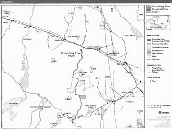
Enlarge figure 1 map of Groundhog River Provincial Park
Figure 2: Park Boundary
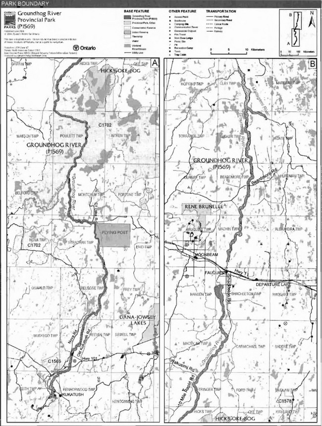
Enlarge figure 2 map of Groundhog River Provincial Park
2.1 Environmental Assessment
As part of the Ontario Ministry of Natural Resources (MNR), Ontario Parks is a public sector agency that is subject to the Environmental Assessment Act. Management of the waterway park will be carried out in accordance with legislation, policies and MNR's A Class Environmental Assessment for Provincial Parks and Conservation Reserves (OMNR 2005a).
3.0 Park features and values
Approximately 180 kilometres of the Groundhog River is protected by the provincial park. This waterway class park was designated under Ontario’s Living Legacy Land Use Strategy as being a highly diverse waterway which is representative of approximately 22 different landform/vegetation associations.
3.1 Geological features
The bedrock of the northern part of Groundhog River Provincial Park is in the eastern Quetico Subprovince, with a very small segment within the Wawa Subprovince. The bedrock of the central and southern part of the park is the western Abitibi Subprovince (Frey and Duba 2002). All three subprovinces are components of the Archean Superior Province.
The geological features of the Groundhog River Provincial Park are regionally significant. It contains Archean felsic to intermediate and mafic metaplutonic and supracrustal metasedimentary components of the Abitibi Subprovince, felsic to intermediate and mafic gneissic of the Quetico Subprovince components and younger Proterozoic diabase dykes in the southeastern part of the Archean Superior Province (Frey and Duba 2002).
Groundhog River Provincial Park is covered primarily by glacial till ground moraine and subordinate bedrock-drift. The glacial till found in this area is sandy silt to silt with rare fine sand. The bedrock-drift is a discontinuous sandy till cover over the bedrock. The Quaternary deposits are late Wisconsinan in age (Frey and Duba 2002).
3.2 Biological features
The dominant vegetation types of the Groundhog River include mixed conifer and mixed deciduous forests. Lake sturgeon are one of 23 fish species know to inhabit the Groundhog River (Seyler 1997b). Lake sturgeon are distributed throughout the lower sections of the river,from its mouth at the Mattagami River, upstream to Upper Falls,which is a natural barrier (Seyler 1997a). Lake sturgeon is listed by the Ontario Natural Heritage Information Centre (NHIC) as globally vulnerable (G3 rank) and provincially rare to uncommon (S3 rank) (OMNR 2004b).
A biological survey of the Groundhog River Provincial Park has not been completed.
3.3 Cultural setting
A cultural history survey and analysis of the features of this park has not been completed.
Any future planning will be within the context of a provincial framework, A Topical Organization of Ontario History (OMNR 1974). In addition, updates and discussions with First Nations, other agencies and stakeholders may be carried out to identify cultural heritage values and features within the park and their significance. This information may be used to develop management guidelines to conserve and protect representative archaeological and historical values and features, or to provide direction for further research.
3.4 Recreation
The protection of this waterway is important in the management of the Groundhog River Provincial Park. Recreational opportunities in the park are largely water-based.
As a large river in northern Ontario, the Groundhog River offers a remote canoeing experience. This canoe route is an advanced-level river trip. Canadian Canoe Routes (2003) describes the route as being from the north of Groundhog Lake to the town of Fauquier; however, this river trip can be extended to conclude at James Bay, or at any point along the Mattagami or Moose Rivers. This river also provides canoeists with several series of rapids and white water.
Other recreational activities which could be supported within this provincial park are fishing, camping, nature appreciation, and hunting (Harper 2003).
4.0 Aboriginal uses
Groundhog River Provincial Park lies within the 1905 AE Treaty (Treaty #9) and adjacent to the Flying Post Indian Reserve.
First Nations have expressed interest in and have shared knowledge of the park and surrounding area. Aboriginal communities have used the area for hunting, trapping, fishing, gathering and travel. These uses may continue, subject to public safety, conservation and other considerations.
Any communications and cooperation between Aboriginal communities and the MNR for planning and operations purposes will be done without prejudice to any future discussions or negotiations between the government of Ontario and Aboriginal communities.
5.0 Stewardship policies
The removal, damage or defacing of Crown property, natural objects, relics and artifacts is not permitted in provincial parks (Provincial Parks Act).
Non-native species will not be deliberately introduced into the park. Where non-native species are already established and threaten park values (i.e., has become invasive), a strategy to control the species may be developed (OMNR 1992).
5.1 Terrestrial ecosystems
5.1.1 Vegetation
Harvesting
Commercial forest harvesting and renewal activities are not permitted within the park (OMNR 2004a).
The harvest of non-timber forest products such as club moss, Canada yew, etc., will not be permitted within the park. Existing authorized wild rice harvesting may continue. New operations will not be permitted (OMNR 1992).
There are no fuelwood cutting permits currently issued for the park. New permits will not be issued (OMNR 2000).
Insects and disease
Insects and diseases may be managed where the aesthetic, cultural, or natural values of Groundhog River Provincial Park are threatened (OMNR 1992).
Control measures will follow guidelines established by the Ontario Ministry of the Environment (MOE) and MNR. Whenever possible, biological control measures will be given preference over the use of chemicals (OMNR 1992).
Fire
Groundhog River Provincial Park is located within the Boreal Fire Management Zone. In accordance with existing provincial park policy and the Forest Fire Management Strategy for Ontario (OMNR 2004c), forest fire protection will be carried out in Groundhog River Provincial Park as on surrounding lands.
Whenever feasible, MNR's Forest Fire Management program will use techniques which minimize damage to the landscape, such as limiting the use of heavy equipment or limiting the number of trees felled during response efforts (OMNR 2004c).
5.1.2 Wildlife Management
Groundhog River Provincial Park is located within Wildlife Management Units 24, 30, and 31. The removal or harassment of non-game animals is not permitted in provincial parks (Provincial Parks Act).
Hunting
Sport hunting is permitted to continue. Considerations of safety and conservation with respect to hunting may be made through future management planning, which includes public and Aboriginal consultation (OMNR 2000).
The Fish and Wildlife Conservation Act (1999) and the Migratory Birds Convention Act (1994) govern hunting within the park. The Ontario Hunting Regulations Summary contains regulations specific to this area. The harvest of bullfrogs or snapping turtles is illegal in provincial parks.
Bear management areas
Groundhog River Provincial Park includes portions of 10 allocated bear management areas; KA-24-022, KA-24-023, KA-30-001, KA-30-002, CP-30-27, CP-30-29, CP-30- 031, CP-30-32, Tl-31-020, and Tl-30-041 (Figure 3).
Existing commercial bear hunting operations are permitted to continue. This activity may be subject to conditions identified during future management planning (e.g. the designation of nature reserve zones).
New BMA licences will not be permitted (OMNR 2000; 2003).
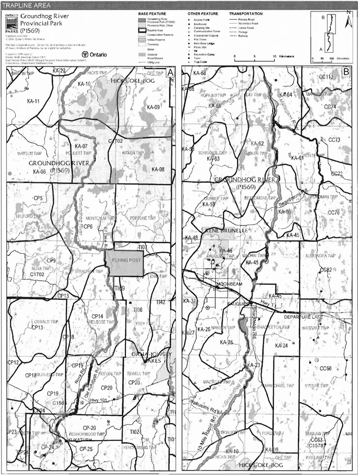
Trapping
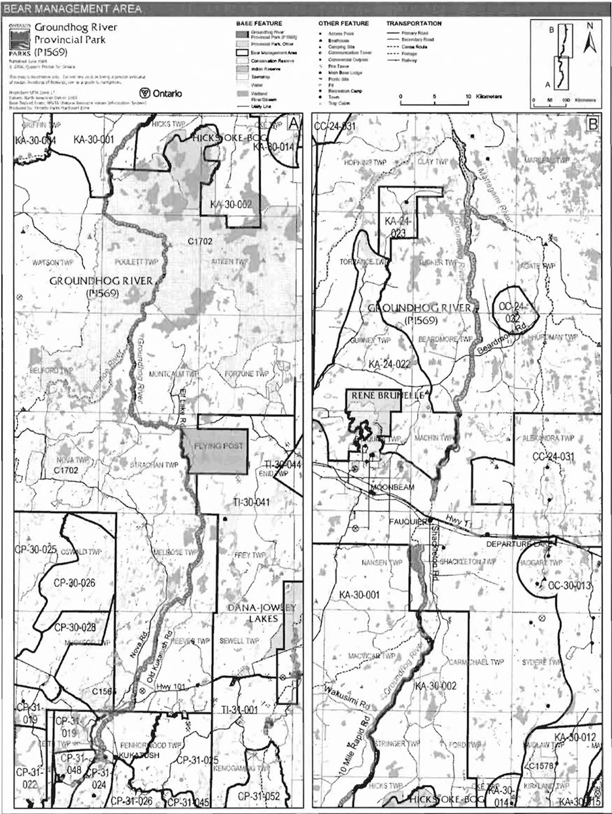
Portions of 18 active trap lines are located in Groundhog River Provincial Park; Tl-06, Tl-67, Tl-68, Tl-69, CP-6, CP-19, CP-20, KA-07, KA-10, KA-22, KA-23, KA-25, KA-45, KA-46, KA-60, KA-61, KA-62, and KA-64 (Figure 4).
The active trap lines that have trap cabins located within the park boundary are Tl-06, CP-06 (two cabins), KA-07, KA-10, KA-23, KA-25, KA-45, KA-60, and KA-62.
Existing commercial fur harvesting operations may continue where the activity has been licensed or permitted since January 1, 1992. New operations, including trap cabins and trails, will not be permitted (OMNR 2000; 2003).
Figure 3: Bear management areas
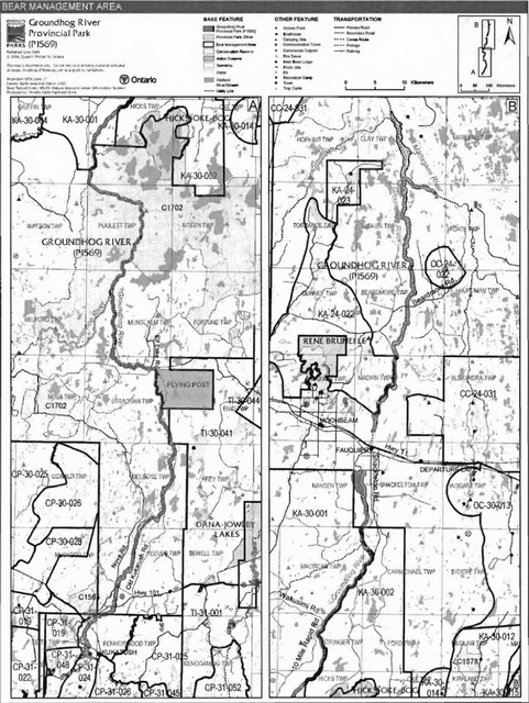
Enlarge figure 3 map of bear management areas
Figure 4: Trap line areas
Enlarge figure 4 map of trap line areas
Transfers of active trap line licenses are permitted, subject to a review of potential impacts and the normal transfer or renewal conditions that apply1.
5.1.3 Industrial resources
The extraction of sand or gravel is not permitted within the park.
There are no existing mining claims within the park. Mining and surface rights on all lands within the park have been withdrawn from staking under the Mining Act (1990). Mineral exploration and mineral extraction are not permitted in the park (OMNR 1992).
5.1.4 Access and crossings
Access
There is one documented unmanaged access at Upper Falls along the Groundhog River in Reeves Township.
Other unofficial, unmanaged access points occur in Melrose, Enid, Strachan, Montcalm, Paulett, Stringer, Carmichael, Beardmore and Clay townships. Many of these unofficial access points occur along forest access roads and municipal roads.
The river is also accessible from within the Community of Fauquier; this portion of the river was deferred from regulation in the waterway park to allow time to resolve land use questions.
The use of unmanaged access points will be reviewed during future planning, which includes public and Aboriginal consultation.
Roads
The following is a summary of the roads located within or crossing the boundary of Groundhog River Provincial Park.
Reeves Township:
- Highway 101 crosses over the river (bridge)
- Nova Road (Tembec) travels parallel to the river
- A dirt road follows the utility corridor to the river
- A road/trail (7 km) travels to just below Camus Rapids
Melrose Township:
- Nova Road (Tembec) travels north through this township, to the west of the park
- Old Kukatush Road (tertiary) travels north-south through township and enters the 200 m boundary at several locations
Enid Township:
- Old Kukatush Road (tertiary) travels north-south through township and enters the 200 m boundary at several locations
Strachan Township:
- Old Kukatush Road (tertiary) enters into boundary north of Flying Post First Nation
- Bridge crossing of a forest hauling road (Tembec), near Camp Main Road, at Six Mile Rapids
Montcalm Township:
- A forestry road (Tembec) travels along the north shore of the river
- Elf Lake Road
Stringer Township:
- 10 Mile Rapid Road (Tembec) travels to the west of the river
- Wakusimi Road (Tembec) approaches 10 Mile Rapid Road from the west
- These roads support a large network of tertiary roads on both sides of the river which have been used for harvesting purposes in the past
- The tertiary roads enter into the 200 metre boundary of the park at various locations
MacVicar Township:
- A large network of abandoned forest access roads is located on the west side of the river
- The CP80 Haul Road (Tembec) crossed over the river in the past, but this crossing has been removed
Carmichael Township:
- Shackleton Road (Tembec) travels in a north-south direction to the east of the park
Shackleton Township:
- Shackleton Road (municipal and Tembec) travels in a north-south direction to the east of the park
- There is a network of abandoned tertiary roads located on the west side of the park
Machin Township:
- The Machin Extension (Tembec) is located to the west of the park
Beardmore Township:
- The Beardmore Road (Tembec) approaches the river from the west
- This road crossed over the river in the past, but the crossing has been removed, and the roads located on the east side of the river have been abandoned
Tucker Township:
- An extension of the Beardmore Road travels west of the park
- An extension of the Beardmore Haul Road (Tembec) travels to the water’s edge
Where existing forest access roads are essential for continued access beyond the park for forest management or recreation purposes, and alternative road access does not exist, or road relocation is not feasible, existing roads will continue to be available for access. Continued use will include maintenance and may include upgrades (OMNR 2004a). Ontario Parks is not responsible for the maintenance or upgrade of any roads within the park boundary.
Where other existing access roads are essential for continued access to in-holdings (i.e. land use permits, patent land, etc.) within or beyond the park boundary, and alternative road access does not exist, or road relocation is not feasible, existing roads will continue to be available for access (OMNR 2004a). Ontario Parks is not responsible for the maintenance or upgrade of any roads within the park boundary.
The crossing of waterway parks by new roads may be necessary. The number of crossings will be minimized where possible and they will be managed to reduce their impact on recreational and aesthetic values. Any future road crossings proposed through the park, where park lands are unavoidable, will be reviewed on a case-by-case basis. Protection of park values will be priority and all requirements of the Environmental Assessment Act will be met.
A reinstallation of the Beardmore Road crossing in Beardmore Township may be permitted for future harvesting in this area of the management unit.
Any proposed development or maintenance/upgrading of existing roads must meet all Environmental Assessment Act requirements.
Railway
There are no railway corridor crossings of the Groundhog River within the boundary of this park; however, there are two railway crossings of the river adjacent to the park boundary in Keith and Shackleton townships.
Utility corridors
Utility line corridors cross over this waterway park in Reeves and Carmichael townships. The Carmichael corridor originates at the water dam located at Carmichael Falls. Maintenance of these existing utility lines will be permitted. These activities must adhere to the regulations set out under the relevant acts such as the Environmental Assessment Act, the Canadian Environmental Protection Act (1999) and the Pesticides Act (1990). Maintenance activities shall not impact negatively on the values being protected within this park.
All public utilities (e.g. gas pipelines, transmission lines, communications towers) must avoid park lands wherever possible. New utility corridor crossings may be necessary to maintain essential public services (OMNR 2004a).
Any future utility corridors proposed through the park, where park lands are unavoidable, will be reviewed on a case-by-case basis. Protection of park features and values will be priority and all requirements of the Environmental Assessment Act will be met.
Recreational trails
Snowmobile Trails: There is one authorized snowmobile trail which crosses over the Groundhog River Provincial Park. The Northern Corridor du Nord Snowmobile Association club trail branches from the Ontario Federation of Snowmobile Clubs (OFSC) Trans Ontario Provincial Series (TOPS) trail A, which roughly follows Highway 11 in this area. The local club trail crosses the Groundhog River south of Bremner Island, travels north, then loops back across Bremner Island to rejoin the OFSC TOPS Trail A. The OFSC TOPS Trail A crosses over the Groundhog River north of Hudd Island and Fauquier, and is not within the park boundary.
Canoe Routes: The Groundhog River canoe route travels the length of the park. This route commences north of Groundhog Lake and can be concluded in the Town of Fauquier or at any point along the Mattagami or Moose rivers.
Hiking Trails: A small system of authorized hiking trails was developed at Camus Rapids Island in Reeves Township in 1998. Approximately two kilometres of trails were constructed to view the natural features in this area. The construction of these trails was authorized through a work permit.
5.1.5 Adjacent land management
First Nation communities
Flying Post First Nation is located along the eastern shore of the Groundhog River in Enid Township. The park boundary does not include any First Nation land. It follows the water’s edge along the boundary of Flying Post First Nation lands.
Forestry
Groundhog River Provincial Park travels through three Forest Management Units (FMUs) (Gorden Cosens Forest #438, Smooth Rock Falls Forest #040, and the Romeo Malette Forest #930) (OMNR 2005b).
Spruce Falls Incorporated holds the Sustainable Forest License (SFL) for the Gordon Cosens Forest. The current forest management plan (FMP) for this management unit expires in 2015 (OMNR 2005b).
Malette Incorporated of Timmins is the SFL holder for Smooth Rock Falls FMU. The current FMP for the Smooth Rock Falls Forest expires in 2005 (OMNR 2005b).
Tembec Industries Incorporated, currently manages the Romeo Malette Forest. The management plan for this forest expires in 2007 (OMNR 2005b).
Conservation reserves
Vimy Lakes Uplands Conservation Reserve: Vimy Lakes Uplands Conservation Reserve (C1565) is located east of the Groundhog River in Reeves Township. This conservation reserve (CR) is approximately 3432 hectares in size (OMNR 2004a). This site contains moderately broken shallow sandy till uplands lacustrine clay dominated by black spruce, poplar/aspen, balsam fir, white cedar, and white birch. In addition a weakly broken shallow sandy till plain is presently dominated by old growth balsam fir, old growth white birch, and 41 to 110 year old white cedar (OMNR 1999).
Northern Claybelt Forest Complex Conservation Reserve: The Northern Claybelt Forest Complex Conservation Reserve (C1702) encompasses a portion of Groundhog River Provincial Park. Ontario’s Living Legacy Land Use Strategy describes the CR as a large complex of land and water which represents characteristic ecosystems of the Northern Claybelt Forest. The combined size, location within the claybelt, and diversity of natural features in the CR make it an important contribution toward the conservation of northeastern Ontario’s biological diversity. Representative features within this site include lacustrine deposits with dense coniferous forest, mixed coniferous forest, sparse forest, and fen. This site’s abundant peatland serves links Groundhog River and Hicks Oke Bog Provincial Nature Reserve thus enhancing the ecological integrity of both parks. This CR includes portions of two provincially significant life science sites. The Nat River Uplands (Fortune Township Uplands) contains stands of old growth poplar/aspen, spruce and white birch over bedrock; and a portion of Enid Creek, which is surrounded by young and old growth spruce on two different landform types.
Mining
Falconbridge Limited holds active mining claims within Strachan and Montcalm townships, including one which overlaps the Groundhog River at Six Mile Rapids. The company has discovered a commercially viable nickel/copper ore body in Montcalm Township and plans to bring a mine into full production. This would require a water discharge into the Groundhog River.
Under a Certificate of Approval issued by MOE and a Work Permit issued by MNR, Falconbridge Limited was granted authority to construct a buried pipeline to discharge treated mining effluent into the Groundhog River at Six Mile Rapids.
Through a Memorandum of Understanding (MOU), an agreement has been reached between MNR and Falconbridge Limited to regulate access to the Groundhog River via the Falconbridge Limited pipeline corridor. This agreement will restrict motorized public access along the pipeline corridor access road from Old Kukatush Road to the Groundhog River. Falconbridge Limited, or any other agent(s) authorized by the company, will be permitted to use the road at their discretion for ongoing pipeline monitoring and maintenance purposes. Once the pipeline construction phase has been completed, the corridor access road from Old Kukatush Rd. to the river will be degraded in such a way that it will only be suitable for (ATV) use only. The road will be closed to the public under the Public Lands Act (1990) and will be signed and gated appropriately.
In the future, when mining operations are terminated, and when the pipeline corridor access road is no longer necessary for monitoring or maintenance purposes, the pipeline corridor will be rehabilitated within the regulated park area to a condition that is satisfactory to Ontario Parks. At that time, all gates and signs will be removed from the pipeline corridor.
Park values have been considered throughout the approval process for this development project. Issues have been addressed through consultations with the MOE, Ministry of Northern Development and Mines (MNDM), Ontario Parks, the Chapleau District MNR, and Falconbridge Limited.
Adjacent tourism
There is one main base lodge located near the southern boundary of Groundhog River Provincial Park. This lodge is situated on private land on the eastern side of the Groundhog River and is outside the park.
5.1.6 Land disposition
New land disposition for the private use of individuals or corporations will not be permitted (OMNR 1992; 2000).
Land Use Permits. Licenses of occupation. Unauthorized occupations
There are 18 private recreation camp land use permits (LUP) located within the park in Beardmore (1), Machin (10), Shackleton (5), Paulett (1), and Reeves (1) townships.
Existing authorized LUPs for recreation camps may be eligible for enhanced tenure but not the purchase of land. Recreational camp LUPs cannot be changed to commercial LUPs unless this is supported during a review as part of park management planning. Enhanced tenure, is defined as a possible extension of the term of the land use permit for recreation camps up to 10 years or upgrade in tenure (i.e. land use permit to lease) (OMNR 2000a).
Enhanced tenure for an LUP for a recreation camp is not guaranteed. Requests for enhanced tenure, or to transfer recreation camps, will be reviewed based upon the following criteria:
- Continued compliance with the conditions of the LUPs for recreation camps
- Current land disposition policies for LUPs
- Consistency with park objectives to sustain values - no effects on heritage values and/or conflict with other uses
- Consistency with Aboriginal land claim negotiations or protocol agreements
- All rents, taxes, fees, rates or charges are paid and in good standing
An extension in the term of tenure for an existing private recreation camp LUP does not convey a commitment to provide for a change in the type or the standard of existing access to the private recreation camp.
There is one commercial outpost LUP located within the park (Section 6.3).
There are no known licenses of occupation or unauthorized occupations within park boundaries.
Patent land
The boundary of this park, in Keith Township, is fragmented due to adjacent patent land. The boundary of the park is also disrupted by a large block of patent land in Shackleton and Machin townships. These parcels of patent land are not included within the park and as such the policies and legislation of the Provincial Parks act do not apply to these lands.
Boat caches
There are six unauthorized boat caches located along the river within Groundhog River Provincial Park. As stated in the Provincial Parks Act (1990), watercrafts are not permitted to be left unattended in a park without written permission from the superintendent. This use will be reviewed during the park management planning process, which includes public and Aboriginal consultation.
5.2 Aquatic ecosystems
Sustaining high water quality resources is integral to the protection of park and adjacent lands' values. MOE enforces applicable legislation and regulations for water quality.
The Mattagami River basin is part of the Moose River drainage system. The total drainage area for the Mattagami River watershed is approximately 35 612 km2. The basin is comprised of the Mattagami, Kapuskasing, Groundhog, and Moose rivers. The Mattagami River System Water Management Planning Final Plan (Ontario Power Generation 2005) addresses the management of in-stream flows and levels in the river that are affected by the operation of waterpower/water control projects.
5.2.1 Water management
There is one hydro water structure in Carmichael Township at Carmichael Falls (first falls) within the park. This dam is owned and operated by Beaver Power Corporation. This dam is a 'run of the river' operation, meaning that it produces hydro without appreciable changes in river flow.
No new water control structures will be built and where existing water control practices are discontinued, existing structures may be removed or allowed to deteriorate, unless they are essential for water control outside of the park, or unless their removal would be more environmentally detrimental than their retention (OMNR 1992). The replacement of existing structures with new structures may be considered through future management planning (OMNR 2004a).
5.2.2 Fisheries management
Fisheries management will complement the maintenance and enhancement of native, self sustaining fish populations. Non-native fish species will not deliberately be introduced into the park waters contained (OMNR 1992).
Sport fishing
Sport fishing is permitted within the park. This activity is governed by legislation and regulations in the Fish and Wildlife Conservation Act (1999) and the Fisheries Act (1985). The Recreational Fishing Regulations Summary contains details on regulations which are applicable to this area.
Commercial fishing
There are no commercial fishing operations within the boundary of Groundhog River Provincial Park. New operations will not be permitted (OMNR 2004a).
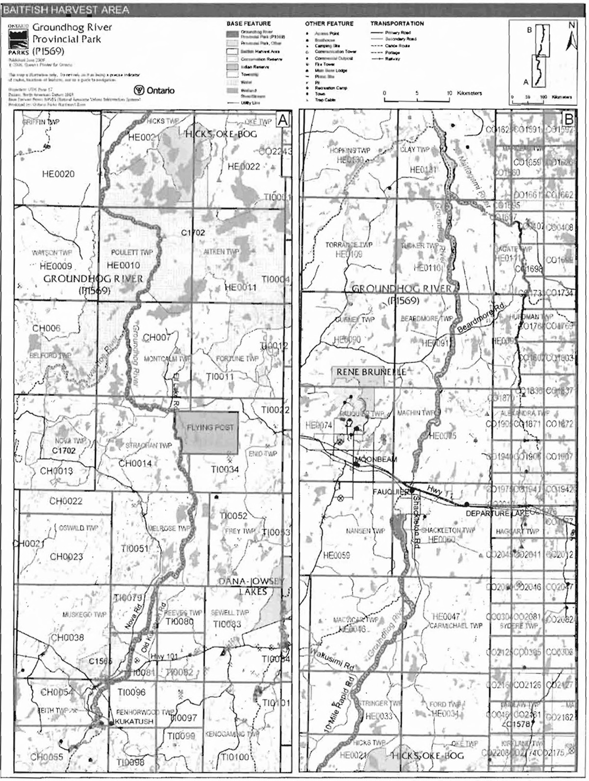
Commercial baitfish harvesting
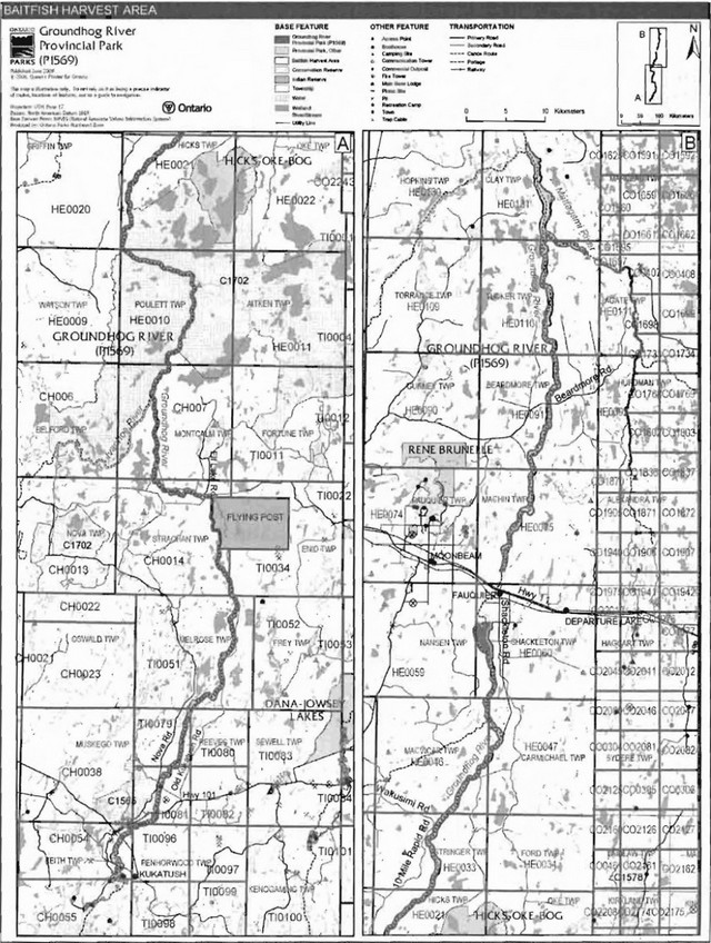
Active commercial baitfish harvesting licenses occur within Hearst MNR District including Tucker, Beardmore, Machin, Shackleton, Carmichael, MacVicar, and Stringer townships (Figure 5). Hicks. Paulett and Clay townships do not have active licenses for bait fish harvesting. These unlicenced townships may be allocated only if there is a record of activity since January 1, 1992 (OMNR 2003). Within the Chapleau MNR District, the townships of Keith, Montcalm, and Strachan have active baitfish harvesting licenses.
Figure 5: Baitfish harvest area
Enlarge figure 5 map of Baitfish harvest area for Groundhog River Provincial Park
Within the Timmins MNR District, the townships of Enid, Melrose. Reeves. and Penhorwood have active harvesting licenses.
Existing commercial baitfish harvesting may continue where the activity has been licensed or permitted since January 1. 1992. This use may be subject to conditions identified through future planning.New baitfish licenses will not be permitted (OMNR 2000; 2003).
Fish stocking
The stocking of native fish species may be considered through park management planning, with full public consultation.Non-native fish species will not be deliberately introduced into park waters (OMNR 1992).
6.0 Operations policies
6.1 Recreation management
Future planning, with full public and Aboriginal consultation,will review the direction on motorized and non-motorized recreational uses.
6.1.1 Motorized recreation
Motorboats
The waters within the boundary of Groundhog River Provincial Park which support mechanized water travel will continue to do so, unless park values are being threatened.
Snowmobiles
The use of authorized snowmobile trails is permitted to continue subject to management prescriptions determined through future planning. which will include public and Aboriginal consultation (OMNR 2004a).
Snowmobile use on established routes for access to private land in-holdings, LUP areas, and recreational ice fishing is permitted to continue unless this use is in conflict with park values or other recreational pursuits.
Off-trail snowmobile use is not permitted within the park.
Future planning, which will include public and Aboriginal consultation, will evaluate all snowmobile use in this park. Proposals for new trails may only be considered through future planning with public and Aboriginal consultation (OMNR 2000).
All-terrain vehicles
There are currently no authorized ATV trails located within the park.
The off-road/off-trail use of ATVs will not be permitted within park boundaries unless authorized by the superintendent under the authority of the Provincial Parks Act.
The use of ATVs on established trails for access to private land in-holdings and LUP areas is permitted to continue in the interim. Proposals for new trails may only be considered through future planning with public consultation (OMNR 2000).
Aircraft
Aircraft landings are permitted in the park (OMNR 2004a). All aircraft landings are subject to regulation and valid aircraft landing permits issued by the park superintendent under the authority of the Provincial Parks Act. Long-term direction for aircraft landings will be determined through future planning.
6.1.2 Non-motorized recreation
Camping
There is one unmanaged campsite located in Reeves Township at the documented access point at Upper Falls. There are also several unmanaged camping sites along the river that are used in association with canoeing on the river.
Existing use may continue in the interim, unless park values are threatened. Long-term management direction for camping facilities will be determined through park management planning, with full public consultation (OMNR 2004a).
Ontario Parks may assess the condition of existing campsites and will maintain, rehabilitate or close sites as required. If there is an identified need, new backcountry campsites may be considered (OMNR 2004a). Infrastructure will be permitted in order to protect park features and values in response to use, environmental deterioration and environmental protection requirements. Any proposed development in the park must fulfill the requirements of the Environmental Assessment Act.
Hiking
The use of the authorized hiking trails at Camus Rapids Island is permitted to continue.
Unauthorized hiking trails and other non-mechanized trails may be permitted to continue in the interim. The park superintendent may discontinue existing unauthorized trails if it is determined that such trails threaten park features and values, create user conflicts or raise safety and/or liability issues.
If there is an identified need, the development of new hiking trails may be considered. Trail infrastructure to protect park values and features will be permitted. Any proposed development within the park is subject to Environmental Assessment Act requirements.
Canoeing/kayaking
Existing canoeing and kayaking uses may continue, unless park values are threatened (OMNR 2004). Infrastructure to protect park features and values may be permitted and developed in response to use, environmental deterioration and environmental protection requirements.
6.1.3 Emerging recreation uses
There are emerging recreation uses for which there is limited or no policy to deal with their management (e.g. adventure racing, geocaching). The park superintendent will use legislation, policy and guidelines that are in place in the interim to manage emerging uses.
6.2 Development
There is currently no infrastructure within the park. Infrastructure to protect park features and values may be permitted and developed in response to use, environmental deterioration and environmental protection requirements. Any proposed development within the park is subject to the Environmental Assessment Act.
6.3 Commercial tourism
There is currently one LUP issued for commercial tourism use within the park in Hicks Township.
Existing authorized tourism facilities are permitted to continue, subject to management prescriptions determined through future management planning, which will include full public and Aboriginal consultation (OMNR 2000).
New commercial tourism facilities may be considered where consistent with park policy (OMNR 2004a). Any development must meet the requirements of the Environmental Assessment Act.
7.0 Cultural resources
An assessment of the cultural resources of Groundhog River Provincial Park has not yet been completed. The management of any cultural features and values within this park will be directed toward protection and heritage appreciation (OMNR 1992).
8.0 Heritage education
Literature and other supporting information may be developed to describe the park in the context of Ontario’s provincial park system. Boundary limits, significant heritage features and permitted uses of the waterway park may be included in park literature.
Prospective park visitors may be informed about the sensitivity and significance of park values through park literature.
9.0 Research
Scientific research by qualified individuals which contributes to the knowledge of natural or cultural history, or to environmental or recreational management, may be encouraged in the park. Ontario Parks will encourage institutions, such as universities, to undertake research projects.
All research programs will require the approval of Ontario Parks and are subject to park policy and other applicable legislation. Any materials removed from the park will remain the property of Ontario Parks.
Approved research activities and facilities will be compatible with the park’s protection objective. Any site which is affected by research will be rehabilitated as closely as possible to its original state. Environmental Assessment Act requirements will apply.
10.0 References
Canadian Canoe Routes, 2003. Canadian Canoe Routes: A Meeting Place for Canadian Wilderness Travellers. Online. www.myccr.com
Canadian Environmental Protection Act, 1999.
Environmental Assessment Act, 1990.
Fisheries Act, 1985.
Fish and Wildlife Conservation Act, 1999.
Frey, E. and D. Duba. 2002. P1569 Groundhog River Waterway Provincial Park. (Draft Earth Science Checksheet).
Harper, T. 2003. Groundhog River Provincial Park (P1569) Recreation Inventory Report – Version 1.1 (Draft).
Migratory Birds Convention Act, 1994.
Mining Act, 1990.
Ontario Ministry of Natural Resources, 1974. A Topical Organization of Ontario History. Historic Sites Branch Division of Parks.
Ontario Ministry of Natural Resources, 1992. Ontario Provincial Parks Planning and Management Policies.
Ontario Ministry of Natural Resources, 1999. Ontario’s Living Legacy Land Use Strategy.
Ontario Ministry of Natural Resources, 2000. Ontario Provincial Park Policy as Amended by the Ontario Living Legacy Land Use Strategy.
Ontario Ministry of Natural Resources. 2003. Directions for Commercial Resource Use Activities in Provincial Parks and Conservation Reserves. 5 pp.
Ontario Ministry of Natural Resources. 2004a. Crown Land Use Policy Atlas.
Ontario Ministry of Natural Resources. 2004b. General Element Report: Acipenser fulvescens. Natural Heritage Information Centre.
Ontario Ministry of Natural Resources, 2004c. Forest Fire Management Strategy for Ontario. Aviation and Fire Management Branch.
Ontario Ministry of Natural Resources. 2005a. A Class Environmental Assessment for Provincial Parks and Conservation Reserves.
Ontario Ministry of Natural Resources, 2005b. List of Forest Management Units and Forest Management Plan Renewal Schedule 2005.
Ontario Power Generation, 2005. Mattagami River System Water Management Planning Final Plan May 2005. Report submitted to the Ontario Ministry of Natural Resources on behalf of Ontario Power Generation, Tembec Industries Inc. and Brookfield Power. 2 vols.
Pesticides Act, 1990.
Provincial Parks Act, 1990.
Public Lands Act, 1990.
Seyler, J. 1997a. Adult Lake Sturgeon (Acipenser fulvescens) Habitat Use, Groundhog River 1996. NEST Technical Report TR-035.
Seyler, J. 1997b. Biology of selected riverine fish species of the Moose River Basin. NEST Technical Report IR-024.
Appendix A: Background information
| Name | Groundhog River Provincial Park (P1569) |
|---|---|
| Classification | Waterway |
| Ecoregion/ecodistrict | 3E-1 (Clay Belt), 3E-5 (Foleyet) |
| OMNR Administrative region/district | Northeast - Hearst, Cochrane, Timmins, Chapleau |
| Total area (ha ) | 13,960 |
| Regulation date & number | June 21, 2006 O. Reg. 331/06 |
Representation
Earth science:
The bedrock of the northern part of Groundhog River Provincial Park is in the eastern Quetico Subprovince, with a very small segment within the Wawa Subprovince. The bedrock of the central and southern part of the park, about three-quarters of the length of the waterway, is the western Abitibi Subprovince. All three subprovinces are components of the Archean Superior Province.
The area of Groundhog River Provincial Park is covered primarily by glacial till ground moraine and subordinate bedrock-drift. The glacial till found in this area is sandy silt to silt with rare fine sand. The bedrock-drift is discontinuous sandy till over bedrock. These Quaternary deposits are late Wisconsinian in age (Frey and Duba 2002).
Life science:
Groundhog River Provincial Park is representative of approximately 22 different landform vegetation associations. Dominant vegetation types include mixed conifer and mixed deciduous forests. The Groundhog River has excellent sturgeon fisheries and brook trout feeder streams.
Cultural resources:
No investigation into cultural resources of the Groundhog River has been completed at this time.
Recreation and tourism:
Recreation opportunities for Groundhog River Provincial Park are largely water based. Canoeing, boating (small watercraft) and fishing are the most common recreational activities that occur within this park.
Some hiking/walking trails have been developed at Camus Rapids in Reeves Township.
Inventories
| Survey level | Earth science | Life science | Cultural | Recreational |
|---|---|---|---|---|
| Reconnaissance | Frey and Duba, 2002 | Harper, 2003 |
1Transfers include situations where a license is surrendered with a request that it be immediately reissued to another individual or organization that is assuming an existing operation. Trap cabins are considered part of a trapline and would be transferred with the trapline for the purposes of trapping. If a trapline license is revoked or surrendered, all portions of the registered line within the park will be rescinded from the legal description of the trap line (OMNR 2003).