Grundy Lake Provincial Park Management Plan
This document provides direction on the management of Grundy Lake Provincial Park.
Amendment approval statement (2018)
June 6, 2018
I am pleased to approve this amendment to the 1988 management plan for Grundy Lake Provincial Park. The amendment provides revised direction in the management plan for a road improvement and recreation lane development project.
I would like to express my appreciation to all those who participated in the planning process.
Sincerely,
Bruce Bateman
Director, Ontario Parks
Approval statement (1988)
Grundy Lake Provincial Park was established in 1959 to provide outstanding outdoor recreation opportunities in the popular Georgian Bay tourist area. The park designation has protected the natural values of glacial terrain, dotted with innumerable lakes, ponds and bogs while retaining its tranquility and solitude. The park offers both recreational campers and canoeists a relatively unspoiled environment together with easy access and modem facilities. Grundy Lake supports locally life science values, forming a valuable component in the provincial park system.
We are pleased to approve the Grundy Lake Provincial Park Management Plan, as official policy for the management and development of this park. The plan reflects this Ministry’s intent to protect natural and cultural features of Grundy Lake and maintain and develop low-intensity opportunities for outdoor recreation and heritage appreciation for both residents and visitors to the Province.
Allan J. Stewart
Regional Director, Algonquin Region
Norm R. Richards
Director, Parks and Recreational Areas Branch
1.0 Introduction
Grundy Lake Provincial Park is situated in the Township of Mowat in the Territorial District of Parry Sound, 13 km east of Georgian Bay on Highway 69 and 80 km from both Parry Sound and Sudbury (Figure 1). This Natural Environment class park totals 3,668 hectares in size, incorporating seven lakes and the southern portion of Bucke Lake. In 2003, 1,115 hectares were added to the existing 2,554 hectare park as part of Ontario’s Living Legacy Land Use Strategy (OLL; 1999; Figure 2). Management direction for the OLL addition areas is outlined in the Grundy Lake Additions Interim Management Statement (2007).
Grundy Lake Provincial Park is managed in accordance with the purpose, principles and objectives outlined in the Provincial Parks and Conservation Reserves Act, 2006 (PPCRA). The PPCRA outlines that Ontario Parks’ first priority in park planning and management is the maintenance of ecological integrity.
Amendments to this 1988 Grundy Lake Provincial Park management plan were approved in 2003 and 2018. They were incorporated into this management plan in 2018, along with some administrative updates to park information and associated maps.
For summer camping visitors, the park offers 476 developed campsites for both tents and trailers in nine individual camping areas (Figure 2). Of these, 181 campsites are equipped with electrical service. The main campgrounds encompassed by Grundy, Gurd and Gut Lakes contain three centralized comfort stations and a number of vault toilets. Three group campgrounds are situated on Grundy Lake; these are not equipped with electrical service. As well, the park maintains an eight hectare day use area located between Grundy and Gut Lakes. The primary recreation beaches are located at both Gurd and Grundy Lakes.
Grundy’s visitor services include a 500 seat amphitheatre and three marked interpretive trails.
The entrance to the park is one km east of Highway 69/400 on Highway 522. Gate staff at the park office direct visitors to the day use area or assign and register individual campsites to campers. The park office also sells park merchandise and firewood. A firewood storage yard and trailer filling and dumping station are located on the west side of the entrance road north of the park office. An additional trailer filling station occurs on the east side of the main road north of the park office.
Grundy Lake Provincial Park is represented by both Middle and Late Precambrian rocks. The topographic expression of the park is that of a moderately rolling glacially scoured wave-washed Precambrian peneplain. There are no significant surficial geological features in the park, although representative features such as crescentic gouges, lunate fractures and potholes are common.
Ecologically, Grundy Lake Provincial Park is situated in the Great Lakes-St Lawrence Mixed Forest Zone. Nature Reserve zones contained within the park represent a variety of vegetative communities, including wetlands, upland forests, rocklands and aquatic environments. They also protect a number of rare and unusual species of flora and fauna, such as Blanding’s turtle (Emydoidea blandingi), least bittern (Ixobrychus exilis), boreal chickadee (Parus hudsonicus), golden-winged warbler (Vermivora chrysoptera) and arethusa orchid (Arethusa bulbosa).
Grundy Lake lies within a moist continental climatic region characterized by short warm summers and long cold winters. Being within 13 km of Georgian Bay, Grundy Lake’s climate is influenced in that summers are cooler and winters warmer than regions further inland.
2.0 Summary of significant issues
Grundy Lake has developed into a park that satisfies the needs of its visitors for camping and day use. However, the distinctively different campground areas contain some maintenance and/or design problems.
Some campsites are showing signs of deterioration due to intense campsite densities and heavy use. Trampling of the soil and damage to floor cover and tree roots is causing slow deterioration of the area tree stands as well as erosion problems on campsites.
In many instances natural buffers between campsites are lacking or are of poor quality.
Sport hunting and registered trapping as defined under the Fish and Wildlife Conservation Act, 1997 (FWCA) and regulations have traditionally been permitted in Grundy Lake. Schedule 39 of Ontario regulation 663/98 of the FWCA indicates that signs will be posted to indicate areas of no hunting.
3.0 Classification
Grundy Lake is classified as a Natural Environment park in recognition of its regionally significant landforms and associated plant communities, as well as its capability to provide a diversity of outdoor recreational activities in an attractive natural setting.
Natural Environment parks are attractive and diverse units of land and water emphasizing particular recreational, historical and natural interest. While these parks may include developed recreation areas, their rich and varied environments are the principal reason for establishment. Recreation based on interaction with the natural environment and appreciation of natural and cultural values is dominant.
4.0 Park goal
The goal of Grundy Lake is to maintain and manage the park’s outstanding recreational landscapes, representative natural features and provide high quality recreational and educational experiences.
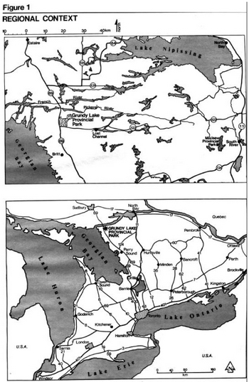
Enlarge Figure 1: Regional context map
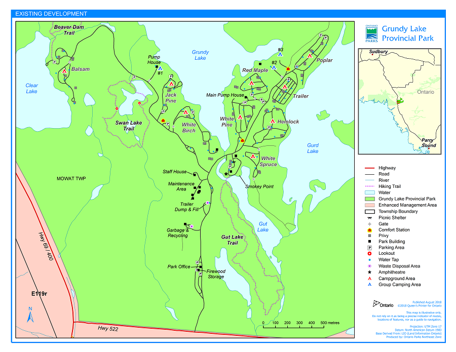
Enlarge Figure 2: Existing development map
5.0 Park objectives
5.1 Protection objective
To protect the natural environment of Grundy Lake Provincial Park incorporating natural and cultural features.
Grundy Lake represents the transition zone between the boreal and deciduous forests, and offers opportunities for high quality low-intensity recreation. By way of development and management strategies, these values such as giant white pines, bogs and wetlands and their representative flora and fauna will be protected by appropriate zoning and direction, and will be emphasized in the visitor services program.
5.2 Recreation objective
To provide day use opportunities in areas of outstanding recreational potential associated with the natural environment of the park.
To provide facility-based camping opportunities in the natural environment of the park associated with areas of outstanding recreational potential.
Grundy Lake offers a diverse range of day use and camping opportunities. Facilities include beaches, three nature trails, as well as day use areas and campgrounds.
5.3 Heritage appreciation objective
To provide opportunities for unstructured individual exploration and appreciation of the natural environment heritage of Grundy Lake.
To provide opportunities for the exploration and appreciation of Grundy Lake’s natural and cultural environments through interpretation and education based on the character of the park.
Grundy Lake Provincial Park offers three self-guiding interpretive trails, providing unstructured opportunities for visitors to learn about the significant natural and cultural features of the park. The visitor services program will supply information on significant features of the park to visitors by means of conducted hikes, audio-visual presentations, leaflets and other means.
5.4 Tourism objective
To provide Ontario residents and out-of-province visitors with opportunities to discover and experience the distinctive region of the park and its environs.
Grundy Lake will provide day use and camping opportunities to travelers in Ontario and destination camping opportunities to travelers attracted from considerable distances and nearby major urban centres such as Sudbury and North Bay.
6.0 Zoning
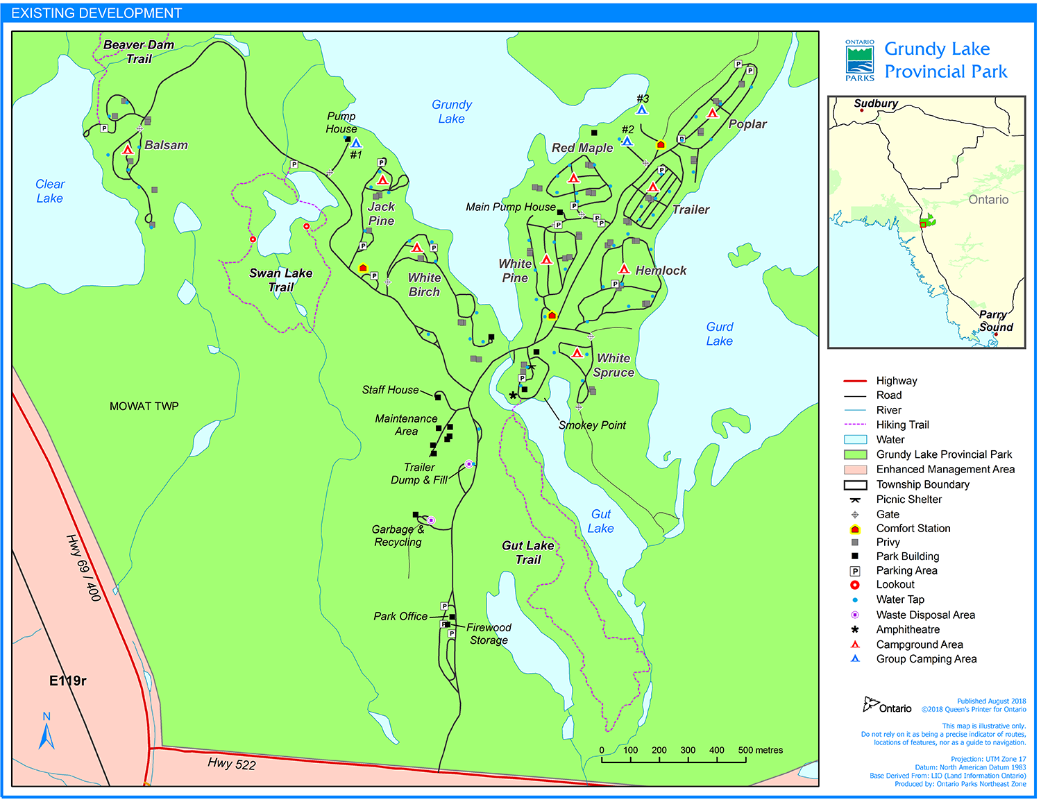
Zoning is essential for the orderly development and effective management of a park. Zoning designations are allocated on the basis of the significance of the land for protection and its potential for recreation within the context of the park’s classification. The parks in each class combine zones in a particular way to provide protection and recreation opportunities distinctive to that class. Natural Environment parks always include Natural Environment and Development zones, and may also include Wilderness, Nature Reserve, Historical and Access zones. Grundy Lake is comprised of Nature Reserve, Natural Environment, Development and Access zones (Figure 3).
6.1 Development zones (117 ha)
Grundy Lake's development zone provides the main access to the park’s facilities and services including the extent of day use and camping activities. Day use and camping facilities will be developed to standards, which will encourage natural environment-based activities and provide for uncrowded conditions and relative freedom from intrusion of fellow recreationists.
This zone includes nine existing campgrounds (Poplar, Hemlock, White Spruce, White Birch, Jack Pine, White Pine, Red Maple, Balsam, Trailer Area) as well as three group camping areas, day use areas and administration facilities. All intensive facility development will be confined to this zone.
6.2 Natural Environment Zone (2,152 ha)
Natural Environment zones include aesthetic landscapes supporting low-intensity recreational activities and minimum development.
This zone, constituting 84 percent of the park, will provide a sufficient land base for extensive recreational activities and a buffer between the Development and Nature Reserve zones. The zone also protects representative earth science features of the Canadian Shield’s Grenville Province.
One significant feature within the Natural Environment zone is the northeast tip of Gurd Lake where four giant white pines (Pinus strobus) occur (Figure 3). These huge pines are of interpretive value to the park, as well as historically being remnants of the white pine logging era.
6.3 Nature reserve zones (261 ha)
Nature Reserve zones include any significant earth and life science features requiring management distinct from that in adjacent zones. Development is limited to trails, necessary signs, minimal interpretive facilities and temporary conveniences for research and management. Portages and signs necessary for hiking trails are permitted.
All Nature Reserve zones will be allowed to proceed through natural succession. If necessary, fires, invasive insects, disease outbreaks, and erosion may be controlled in order to perpetuate natural features and conditions, as well as to protect the remaining park area, adjoining Crown lands and Henvey Inlet First Nation.
Seven Nature Reserve zones within the park have been designated to protect natural life science features for their intrinsic values, interpretation and scientific study. The earth science features within the park are of local significance only. These include representative bedrock outcrops and glacial formations.
The significant and representative life science features of the Nature Reserve zones portray features typical of the park, as well as this area of Ecoregion 5E of Parry Sound District. The zones include a variety of vegetative communities, including wetlands, upland forests, rocklands and aquatic environments.
NR- 1: Swan Lake (48 ha)
The Swan Lake zone contains a variety of wetland and rockland communities characteristic of Georgian Bay’s eastern shoreline. Bogs, marshes, and ponds are common here. The jack pine stands located on the rock ridges of the shoreline are the only major jack pine stands in the region protected in a Nature Reserve outside of Algonquin Park (Figure 3). The area also contains the rare Blanding’s turtle, which is approaching the northern limit of its range, and the rare grass pink orchid (Calopogon pulchellus). The zone is also of high interpretive value with a well-used nature trail circling the northern portion. The abundant wetlands attract a variety of wildlife, creating good viewing opportunities. Glacial features are also found throughout the area.
NR- 2: Gut Lake Wetland (9 ha)
This large area encompassing a small, central lake exemplifies a typical glacial wetland. The site originated as a shallow post-glacial lake slowly filled by vegetation and gradually forming an acidic sphagnum bog, which was later flooded. This has allowed cattails (Typha latifolia) and other species typical of more neutral conditions to invade the area. Features of glacial erosion are present in the bedrock outcrops at the edge of the wetland. The zone is also of high interpretive value as it is a major stop along the Gut Lake Nature Trail.
NR- 3: Beaver Dams (49 ha)
This zone contains a variety of wetland and upland forest communities of high representative value. The area is also notable for its fauna. A colony of great blue herons (Ardea herodias) nest in a small pond north of Grundy Lake (Figure 3). A least bittern nest was found in one of the wetlands. This small nocturnal heron is uncommon regionally and is approaching the northern limit of its range. Otter (Contra canadensis) have been observed in Bucke Lake, while beaver (Castor canadensis) are evident throughout the zone. The area is also of high interpretive value as the Beaver Dams Trail loops through the zone.
NR- 4: Beaver Lake Bogs (6 ha)
This zone, located at the south end of Beaver Lake, consists of bedrock ridges alternating with low wetlands. Both environments contain a number of vegetative communities of high representative value. Rock ridges support sparse stands of pine, whereas troughs contain ponds, bogs, thickets and a large chain fern stand. Chain fern (Woodwardia virginica) is an uncommon species approaching the northern limit of its range. This Atlantic coastal plain genus of fern occurs in Ontario, almost exclusively along Georgian Bay. This is one of two nature reserves along Georgian Bay protecting this unusual species. The other is located in French River Provincial Park.
NR-5: Pakeshkag Hardwoods (32 ha)
This portion of Grundy Lake Provincial Park has been extensively burned and logged in the past, destroying the majority of the original hardwood stands. The sugar maple forest near Pakeshkag Lake is one of the few remaining stands in this area. The forest also supports unusual southern flora, including wild leek (Allium ricoccum) and blue cohosh (Caulophyllum thalictroides).
The zone also contains an extensive cattail marsh, a black ash swamp with a number of uncommon orchids, a cedar swamp and a rocky island. Stands of a rare aquatic species, sweetflag (Acorus calamus) occur along the shoreline.
NR- 6: Pakeshkag Bog (21 ha)
The Pakeshkag Bog stretches along the southern shore of Pakeshkag Lake. This site is of high representative value, being an excellent example of a bog community. Pitcher-plant (Sarracenia purpurea), sundew (Drosera rotundjfolia), cranberry (Vaccinium spp.) and other typical bog species occur here. The bog also includes a number of rare species, the most notable being a rare orchid (Arethusa sp.). An unusual bird, the boreal chickadee has nested in the bog. This species is at the southern limit of its breeding range on Georgian Bay and reflects the northern character of the bog. No hiking, canoeing or development of any kind will be allowed on this fragile site. The bog will be posted to advise canoeists of the nature and importance of the area.
NR- 7: Pakeshkag River Wetlands (96 ha)
The Pakeshkag River Wetlands is an extensive area of marsh, bog and swamp located in the eastern portion of the park. The wetlands contain a wide diversity of vegetative communities of high representative value. A number of unusual species also occur here, including sweetflag and bur oak (Quercus macrocarpa; approaching the northern limit of its range). An excellent stand of bur oak occurs along the west bank of the river. This extensive wetland system provides excellent habitat for a variety of wildlife including the rare golden-winged warbler. The zone is also of high interpretive value as the river provides visual access via canoe.
6.4 Access zone (24 ha)
Access zones are staging areas supporting minimum facilities in Nature Reserve and Wilderness zones, and less developed Natural Environment and Historical zones. At Grundy Lake, the Access zone includes an access road and parking lot for Pakeshkag Lake. This lake provides access to the Pickerel River Canoe Route, which follows the Pickerel River west to Georgian Bay, then south to Key River and finally east to Grundy Lake Provincial Park.
7.0 Resource management policies
The park’s natural resources will be managed in accordance with the general planning and management policies for Natural Environment class parks. Specific direction, where needed to meet the special requirements of Grundy Lake is presented below under a series of headings, each representing one component of the resource base.
Although the policies are presented in separate categories, all subsequent planning and management will recognize the need to integrate these components since they are interrelated.
7.1 Vegetation management
Certain management techniques will be applied to maintain a particular kind and quality of vegetation in a given area of the park. Zones with vegetation progressing through natural succession will have different management techniques from zones where vegetation is maintained at its present stage of natural succession. Commercial forestry operations will not be permitted in Grundy Lake. Non-native plant species will not be deliberately introduced. Where non-native plant species are already established in Nature Reserve zones and threaten the values for which these zones have been established, an eradication program may be developed. Only native species may be re-established if biologically feasible and acceptable, usually to rehabilitate the quality of areas suffering past or present recreational use or development impacts.
The Park Superintendent will supervise all tree cutting operations in the event standing trees are to be cut during development or vegetation management.
All cut wood will, where possible, be used for park purposes such as firewood, posts and saw logs. Such may lead to savings in park operating costs, but it should be remembered the main purpose of management prescriptions will be to maintain or create a particular quality of vegetation and not generate revenue.
Park staff will manage vegetation to meet the diverse management needs specified above. A detailed vegetation plan may be prepared by the Park Superintendent in conjunction with other Ministry staff and/or outside experts as required, and in consideration of the following prescriptions for the following zones.
7.1.1 Development zone
In the day use area north of the main park road, the vegetation will be managed in order to perpetuate a protective overstory and a relatively sparse understory so as to maintain a visual connection among the picnic and beach areas. South of the main park road, the existing vegetative quality will be maintained, with the exception of thinning of the understory to establish a visual connection between the picnic shelter and Gut Lake.
Vegetation quality will be maintained in the existing camping areas. Ground and understory vegetation will be managed to provide and maintain the existing visual buffer for privacy between campsites.
In the entrance corridor, the visual barrier will be maintained in the midst of the park road, sewage disposal area, woodlot, trailer dumping station, and the maintenance and staff area.
The buffer zone dividing the entrance road and the tree line will be restored to have a more natural appearance.
7.1.2 Natural environment zones
In the Natural Environment zones, natural succession will progress unimpeded. Where safety hazards along trails exist, potentially dangerous trees will be removed in association with 'brushing' operations and routine trail maintenance.
7.1.3 Nature reserve zones
Natural succession will be allowed to progress unimpeded in Nature Reserve zones.
7.2 Wildlife
A Wildlife Management Strategy may be prepared for the park to guide resource management activities.
The Park Superintendent will use approved best management practices for wildlife management, and may develop a plan to provide direction in controlling the impacts of beaver, raccoon, and bear on park visitors, to maintain existing water levels, to protect vegetation in Development zones and reduce wildlife nuisance problems in campgrounds.
An Interim Management Strategy is currently in effect.
7.2.1 Trapping
There are two registered traplines that intersect the boundary of the park.
A trapper has been assigned under the direction and audit of the Park Superintendent to trap nuisance animals for management purposes only.
7.2.2 Hunting
Low-intensity sport hunting will be permitted exclusively in the southeast corner of the park as identified in Figure 4, and only in the Natural Environment zone. Traditional hunting camps outside the park have demonstrated a need for hunting opportunities in this zone. Two of these camps have hunted the area for over 75 years.
The Park Superintendent will determine the area and boundary for hunting and when the sport can be effectively separated in time and space from other recreational activities in the zone, and will post signs to delineate areas of hunting and no-hunting. The Superintendent will inform local hunt camps of any changes in the hunting regulations for the park. The areas open to hunting may be closed to hunters temporarily or permanently for wildlife research or management purposes. Hunting and trapping activities will conform to the regulations outlined in the Fish and Wildlife Conservation Act, 1997.
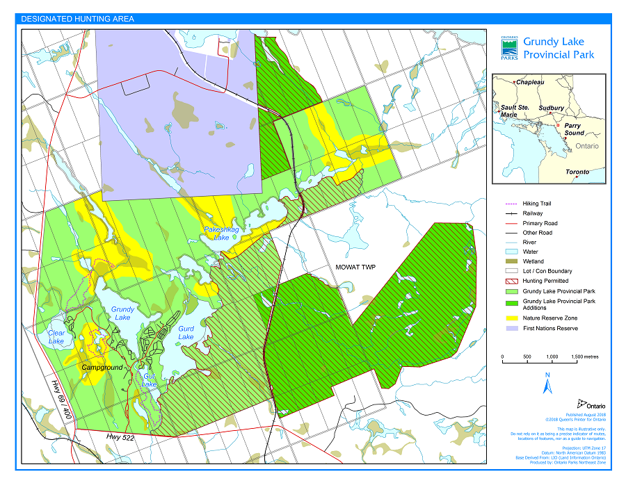
Enlarge Figure 4: Designated hunting area map
7.3 Fisheries
Sport fishing is encouraged in Natural Environment parks. Seasons, size limits, restrictions of catch and stocking programs for put-and-delayed-take sport fishing in Natural Environment and Development Zones occur in accordance with the Fish and Wildlife Conservation Act, 1997 and regulations.
Fishing is not permitted in Nature Reserve zones and will be posted. The use or possession of bait fish will also be prohibited. Certain waterbodies may be closed to fishing temporarily or permanently for fisheries research or management purposes.
7.4 Aggregate resources
Commercial mineral exploration and extraction will not be permitted. Aggregate required for maintenance and capital improvements will be brought in from an external source.
7.5 Fires
Fires in all zones will be managed through the use of standard methods. Chemical controls will not be employed.
7.6 Insects and disease
Measures to control non-native insects and disease will be permitted in all zones where aesthetic or natural values of the park are threatened. Where suppression is desirable and feasible, the controlling agent will be directed as narrowly as possible to the specific threat to minimize impact on other elements of the park environment. If required, control measures will be prescribed in a vegetation management plan.
8.0 Operations policies
8.1 Visitor services
Grundy Lake Provincial Park will offer a seasonal activity level of visitor services programming including the three components of visitor services: information, interpretation and outdoor recreation. The park will be managed in accordance with the current operating plan.
The park office serves as the focal point for visitor registration, information about park resources and activities, and park administration. As the single entry point to Grundy Lake Provincial Park, the office will also control access to the park’s facilities.
Information concerning park resources, (i.e. glacial features, South Shield, transition forest zone, wetlands) management, facilities and programs, and nearby points of interest will be available at key points throughout the park. Information will consist of a park leaflet, newsletter and special publications when required.
The park staff will continually strive to make a visitor’s stay as enjoyable as possible. This involves ongoing orientation and education of all park staff to relevant and current information concerning Grundy Lake, its surroundings, and ways to enhance visitor satisfaction and understanding.
The visitor services program will provide day users and campers an opportunity to gain an understanding and awareness of, and an appreciation for, Grundy Lake Provincial Park, its objectives, policies and its cultural resources.
8.2 Interpretation
Visitors will gain an opportunity to discover the character and history of the park and the numerous earth and life science features and cultural resources of the surrounding park area. Interpretive programs in Grundy Lake and its environs will have self-use facilities such as trails with trail guides. Displays and special exhibits will provide an entertaining and informative look at Grundy Lake and its history.
School and university groups from Parry Sound, Sudbury and other local communities will be welcomed to Grundy Lake. They will be encouraged to take advantage of the park environment, facilities and programs for research and educational purposes, providing their activities are compatible with park values.
8.3 Recreation
Grundy Lake is situated on a landscape that offers excellent potential for canoeing. The lakes within the park offer short day trips in protected waters as well as starting points for canoe tripping. A canoe route from Pakeshkag Lake connects the Pakeshkag River to the Pickerel River, French River, and out to Georgian Bay. The nearby French, Pickerel and Key Rivers offer challenging excursions, camping, and access to Georgian Bay.
Grundy Lake's proximity to French River and Killarney Provincial Park’s excellent canoe routes also adds an extra dimension to its canoeing programs.
8.4 Research
Scientific research relating directly to Grundy Lake Provincial Park’s natural and cultural history, and to environmental and recreational management of natural landscapes, will be encouraged.
All research programs will require the approval of Ontario Parks and must also meet all requirements under applicable Provincial and Federal legislation. The Ministry may approve the removal of fauna, flora, soils and geological samples and archaeological and historical artifacts by qualified researchers. Any such materials removed will remain the property of the Ministry. Approved research activities and facilities will be compatible with protection objectives and recreational uses in the park and will be subject to development and management policies for Natural Environment parks unless special permission is given. Sites altered by research activities will be rehabilitated to their previous condition.
8.5 Marketing
A marketing strategy to attract more visitors to Grundy Lake Provincial Park throughout its operating season will be prepared with the following objectives: to keep present clientele longer (average length of stay 3.3 days in 1986); to have previous visitors return (only half of day users returned during the previous year and campers have dropped 26%); to attract day users staying at local commercial establishments or using local services; to attract more day users and campers from local urban centres (i.e. Sudbury and Parry Sound); to attract campers and day users during low use periods in the mid-week (July-August occupancy rate 67.5%) and shoulder seasons; increase involvement with the commercial sector by encouraging park users to take advantage of local tourist services and attractions, and generally stimulate interaction between the park and the private tourist, and commercial sector in the vicinity. The plan will be reviewed and updated when the need arises.
In 2017, the average length of stay was 4.5 days, campers are up 109% and day users are down by 17% since 1988. In 2017, the July-August occupancy rate was 83%.
9.0 Development policies
Development will proceed in accordance with Figure 5 and the following guidelines. In all instances, detailed site plans will be completed and approved in advance of rehabilitation of existing facilities or the development of new facilities. Development projects will be phased according to the Implementation Priorities Section (10.0) and the park operating plan as needed and funding permits.
The requirements of the Environmental Assessment Act will be adhered to by meeting the requirements of A Class Environmental Assessment for Provincial Parks and Conservation Reserves (2005). A park operating plan will be prepared to provide specific guidelines or the operational aspects of the various park programs.
9.1 Campgrounds
Grundy Lake Provincial Park will continue to offer 476 developed campsites distributed among nine campgrounds and three group camping areas. No major changes are proposed in the developed campgrounds.
Each year selected campsites or campgrounds will continue to be naturally rehabilitated by remaining dormant throughout the operating season. During peak periods, the campsites will be used to accommodate campers and returned to the rehabilitation program when the sites are no longer needed. Restoration of heavily used sites, regular inspection and upgrading of sites and even distribution of use of campgrounds and campsites may occur.
9.2 Recreation facilities
The main beach by White Pine campground on Grundy Lake and Smokey Point on Gut Lake will continue to be the main day use areas of the park. Sand will be added to the main beach when needed and where necessary to maintain sand sufficient for dry beach activities.
The beach area adjacent to White Pine campground receives most of the day use in the park. This area is also popular with campers. Smokey Point on Gut Lake is a focal point for visitor services.
A trail will be established linking the day use area with the park office, thus eliminating pedestrian traffic using the main access road.
A creative, safe playground will be constructed of natural materials such as wood, logs and hemp rope. The play area will be designated in a linked configuration containing a series of climbing devices, balance beam, obstacles, unconventional swings and slides, which will activate the communicative, emotional and physical attributes of a child.
9.3. Visitor centre
A seasonal visitor centre will be built in the day use area at Smokey Point on Gut Lake. The centre will act as an information and interpretive centre. The building that was used as a temporary interpretive facility will be removed. This area also includes an outdoor amphitheatre (Figure 5), outdoor stage, rear screen projection room and a small alcove to house audio and visual equipment.
The exterior will be designed to blend with the natural surroundings. Large windows, where appropriate, will allow as much natural light as possible to enter the building. Washrooms incorporated inside the building will provide facilities required for the centre.
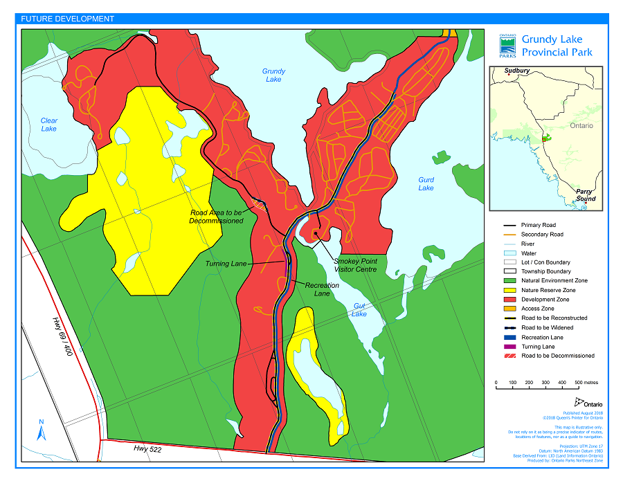
Enlarge Figure 5: Future development map
9.4. Service systems
The location of hydro lines within the park will be re-examined and possibly relocated and/or buried underground.
9.5. Vegetation management strategy
Vegetation management in the various zones of Grundy Lake Provincial Park is listed in Section 7.1 of Resource Management. The following improvements pertain to the campgrounds only. The campgrounds will not be substantially altered but will be modified to attain the quality associated with Natural Environment parks.
A buffer will be established between many of the sites and campground roads. Native species will be planted and natural objects such as logs or rocks may be used to define the entrance to the campsite. Parking areas on the campsites will be well defined.
Selective thinning of underbrush will ensure campsites on lakes have a view and access to water.
Where necessary, sites will be resurfaced and seeded, fill added, and/or erosion control measures implemented.
Campsites exposed to excessive vehicular or pedestrian traffic such as those close to main roads or privies will have an upgraded buffer zone or will be closed.
9.6. Road Improvement and Recreation Lane
Major maintenance of park roads is necessary and bridge work may be required in the future to ensure sound infrastructure. Increased visitation and use of larger vehicles and trailers have resulted in significant road congestion on narrow park roads during the summer months. The roads will be brought up to current design standards for the current level of use to maintain traffic flow and safety.
A recreation lane will be added to the main road to accommodate increasing numbers of pedestrians and cyclists in the park, allow for safe travel from campgrounds to the entrance gate and promote healthy recreation.
10.0 Implementation priorities
This management plan will be reviewed after 10 years following its approval or as the need arises. Data collection and environmental monitoring will be conducted regularly.
The following is a list of projects that have been previously described in this plan. The number of projects to be completed or partially completed will be based upon the availability and allocation of each year’s capital funding. Projects on the list that have been completed or have been determined not to fit into Ontario Parks’ commitment to ecological integrity in 2018 have been flagged.
Priority Project Description Rating
- Road improvement and recreation lane
- Park marketing strategy (completed)
- Add vanities to all vault toilets (partially complete)
- Build comfort station with showers at Jack Pine campground (completed)
- Vegetation management strategy
- continue campsite rehabilitation
- follow prescription for each of the park’s zones.
- Wildlife management strategy
- Park operating plan
- Campsite Maintenance/Upgrading Strategy:
- restoration of heavily used sites
- regular inspection and upgrading of sites
- even distribution of use of campgrounds and campsites
- Develop Smokey Point day use area at Gut Lake
- develop wet and dry beach (ecological integrity concerns)
- eliminate two short sections of road.
- upgrade present trails leading to day use area.
- establish separate trail linking day use and park offices (part of recreation lane project in #1)
- develop playground
- Build Visitor Centre at Smokey Point day use area at Gut Lake
- building including amphitheatre (amphitheatre completed)
- hydro, water and sewage (electricity and water completed)
- equipment and display (completed)
- landscape (completed)
- removal of old amphitheatre (completed)
- Establish group campground for two groups of 10 to 14 campers on former amphitheatre site (completed)
- Install more electrical hookups in Trailer area at existing campsites
- upgrade power supply (completed)
11.0 Summary of public consultation
A tabloid was written in 1984 summarizing the Preliminary Management Plan. These tabloids were distributed to park visitors and sent to local municipalities and adjacent landowners. Copies of the detailed plan were made available at the District and Park offices for those people interested in obtaining more information.
The future of hunting and trapping in Grundy Lake were the only two concerns expressed during the review. The local Trappers Association was concerned that trappers would lose some of their area if the Ministry was to prohibit trapping in Grundy Lake Provincial Park. With present Provincial Park Policy stating that existing traplines in regulated provincial parks should be phased out, the solution of this concern was to withdraw those portions of traplines lying within the park’s boundaries and assign one trapper with the right to trap nuisance animals. This management practice would be strictly supervised by the superintendent.
The hunting question was raised by hunt camps located adjacent to Grundy Lake who have traditionally in hunted in parts of the park. The decision passed supported traditional hunting but only in Natural Environment zone adjacent to the hunt camps affected.
All other aspects of the plan were well received.
In 2003, the OLL (1999) additions were regulated after extensive public consultation on the province-wide land use plan. Detailed direction for the park OLL additions can be found in the Grundy Lake Additions Interim management statement, which applies higher-level approved park policy to the lands covered by the additions. Future park management planning processes, including public consultation, will encompass all lands in Grundy Lake Provincial Park, including the additions, and will enable more detailed park policies to be developed.
There have also been two park management plan amendments to cover development projects in the park. In 2003, the plan was amended to enable the building of the new park office building near the front gate. In 2018, the plan was amended to enable a road improvement and recreation lane project along the main road. Both development projects underwent environmental assessments as well as public consultation. After Ontario Parks addressed comments and concerns, both amendments were approved, and text associated with each amendment was added to this approved management plan.
12.0 References
Carscallen, Carlton. Stage 1 & 2 Archaeological Assessment: Grundy Lake Provincial Park Administrative Centre. Barrie: AFBY Archeological and Heritage Consultants, 2002.
Duba, D., Frey, E. Grundy Lake Provincial Park OLL Additions Earth Science Checksheet. Central Zone Office, Ontario Parks, 2002
Environment Canada. The Tourism and Outdoor Recreation Climate of Ontario, Atmospheric Environment Service, Department of the Environment, Ottawa, 1976.
Heidorn, C. Grundy Lake Provincial Park Additions (P105): Recreation Resource Inventory Report. Central Zone Office, Ontario Parks, 2001.
Kershaw, H. Grundy Lake Provincial Park Life Science Report. Central Zone Office, Ontario Parks, 2004.
Korol, J. A reconnaissance Life Science Inventory of the Proposed Additions to Grundy Lake Provincial Park. Central Zone Office, Ontario Parks, 2001.
McIntyre, E. Fisheries Summary: Lower Pickerel River. Parry Sound District, MNR, 2004.
McIntyre, E. Fisheries Summary: Pakesghkag Lake. Parry Sound District, MNR, 2006.
Ontario Ministry of Natural Resources. Earth Science Reports for Grundy Lake Provincial Park. Unpublished Report, Parks Planning Section, Queen’s Park, 1979.
Ontario Ministry of Natural Resources. French River Provincial Park Management Plan, Parks Planning Section, Queen’s Park, 1985.
Ontario Ministry of Natural Resources. Life Science Reports for Grundy Lake Provincial Park. Unpublished Report, Parks Planning Section, Queen’s Park, 1979.
Ontario Ministry of Natural Resources. North Bay District Land Use Guidelines, Regional Lands Office, 1983.
Ontario Ministry of Natural Resources. Ontario Provincial Parks Policy, Queen’s Park, 1978.
Ontario Ministry of Natural Resources. Parry Sound District Land Use Guidelines, Regional Lands Office, 1983.
Ontario Ministry of Natural Resources, Provincial Parks Statistics. Parks Planning Section, Queen’s Park, 1974-1986.
Ontario Ministry of Natural Resources. Sudbury District Land Use Guidelines, Regional Lands Office, 1983.
Ontario Ministry of Natural Resources. Ontario Provincial Parks Planning and Management Policies, 1992.
Ontario Ministry of Natural Resources. Ontario’s Living Legacy Land Use Strategy. Queen’s Printer for Ontario, 1999.
Ontario Ministry of Natural Resources. A Class Environmental Assessment for Provincial Parks and Conservation Reserves. Queen’s Printer for Ontario, 2005.
Ministry of Natural Resources. Grundy Lake Additions Interim Management Statement. Central Zone Office, Ontario Parks, 2007.
Simpson, H. Nature Reserve Grundy Lake Provincial Park. Ontario Ministry of Natural Section, Algonquin Region, 1979.
Swayze, K. Stage 1 Archaeological Assessment & Cultural Inventory of Grundy Lake Provincial Park in Mowat Township, Parry Sound District. Central Zone Office, Ontario Parks, 2005.