Gulliver River Conservation Reserve Management Statement
This document provides policy direction for the protection, development and management of the Gulliver River Conservation Reserve and its resources.
Statement of Conservation Interest
March 2002
Dryden District
Ministry of Natural Resources
Approval statement
We are pleased to approve this Statement of Conservation Interest for Gulliver River Conservation Reserve (C2292).
This Statement of Conservation Interest will provide guidance for the management of the Conservation Reserve and form the basis for ongoing monitoring of activities. More detailed direction is not anticipated at this time. Should significant facility development be considered or complex issues arise requiring additional studies, more defined management direction, or special protection measures, a more detailed Conservation Reserve Management Plan will be prepared with full public consultation.
The Gulliver River Conservation Reserve will be managed under the jurisdiction of the Ignace Area supervisor, Dryden District, Ministry of Natural Resources.
Charlie Lauer
Regional Director
Northwest Region
Ministry of Natural Resources
R.G. McColm
Dryden District
Manager Ministry of Natural Resources
1.0 Background information
The purpose of this document is to identify and document the natural heritage values of the Gulliver River Conservation Reserve, the activities that occur there and, through a set of management guidelines, lay out the activities that will and will not be permitted. For more information regarding this Statement of Conservation Interest (SCI) please refer to the "Conservation Reserve Policy and Procedure PL3.03.05".
Table 1.1: Background information for Gulliver River Conservation Reserve.
| Name | Gulliver River Conservation Reserve (C2292) |
|---|---|
| Site Region / Site District | 3W-2 |
| OMNR Administrative Region / District / Area | Northwestern Region / Dryden District / Ignace Area, English River Forest |
| Total Area (ha) | 2774 |
| Regulation Date | Anticipated for 2002 |
| First Nations | Ojibway Nation of the Saugeen Band, Wabigoon Lake Ojibway Nation, Aboriginal People of Wabigoon |
| OBM | 15 6150 54585 |
| Latitude / Longitude | 49° 15' / 91° 25' |
| Basemap | 492912, 493912, 492913 |
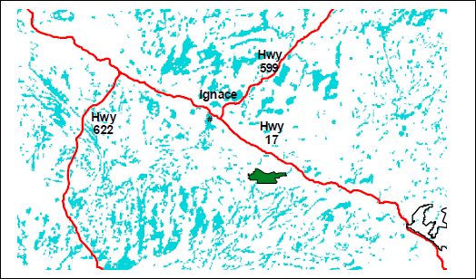
| General Location Description | Located approximately 20 km southeast of Ignace, off of Highway 17 |
| Access | Access can be gained via boat and portage at the Gulliver River Bridge on Grit Road Crescent Road, off Highway #17, also leads into the reserve. Several other forest access roads enter the reserve but few are passable. |
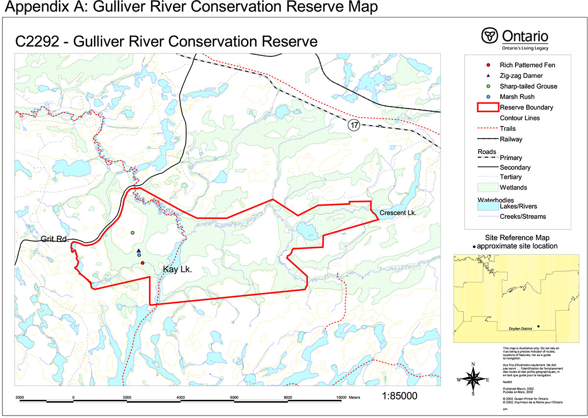
Figure 1: General location of Gulliver River Conservation Reserve
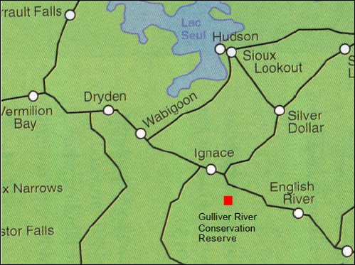
Table 1.2: Representation Targets – A summary of earth science, life science, cultural resource values and present or possible recreational opportunities.
| Life Science Representation | Upland Forest/Forested Dunes: Conifer mixed forest – Jack Pine, White Pine, Red Maple Wetland: Fen – open-saturated to semi-treed conditions Bog – Black Spruce, ericaceous shrubs, Sphagnum moss Meadow marsh Animal Species: Sharp-tailed grouse observed Evidence of muskrat, beaver, eagle and osprey Sufficient habitat for moose, bear and deer. |
|---|---|
| Earth Science Representation | Underlain by granitic rock Beach, delta and aeolian outwash sands Peat accumulation in wetland areas Well-developed active meandering river system |
| Cultural Value Representation | No documented cultural values |
| Recreational Opportunities | Opportunities exist for canoeing, exploring, hunting (large mammals and waterfowl), snowmobiling, fishing, bird watching and general nature activities. |
Table 1.3: Survey Information – Overview of inventories completed, their level of detail and any inventories that are needed.
| Survey Level | Life Science | Earth Science | Cultural | Recreational |
|---|---|---|---|---|
| Reconnaissance | - checklist 2001 - Life Science Inventory |
- checklist 2001 - Earth Science Inventory |
- not required | - checklist 2001 - Recreation Resource Inventory |
| Detailed | - not required | - not required | - not required | - not required |
2.0 Values to be protected
This section provides a description of the key natural heritage values on the site, their condition relative to past resource and management activities, and their sensitivity to future land use and management activities.
Table 2.1: Values identified on Gulliver River Conservation Reserve.
| Life Science |
|
|---|---|
| Earth Science |
|
| Cultural |
|
| Aboriginal |
|
| Tourism |
|
| Recreational Fishing |
|
| Recreational Hunting |
|
| Trapping |
|
| Bear Management Area |
|
| Bait Harvesting |
|
| Commercial Fishing |
|
2.2 Values to be protected
The intent of this SCI is to protect the following values by establishing management guidelines for existing and potential uses in this area given the level of past disturbance and the nature of the existing features.
2.2.1 Forest values
None of the forest values found require additional protection other than that provided by this Statement of Conservation Interest and the Gulliver River Conservation Reserve Policy Report (see Appendix F).
2.2.2 Biological values
Several species of uncommon wetland plant in Northwestern Ontario can be found in the rich patterned fen (see Table 2.1). Some of these are mineral-rich condition indicators including shrubby cinquefoil, starved sedge, livid sedge and Hudsonian club rush.
A few sharp-tailed grouse were spotted in one of the cutovers. These birds are considered a regionally rare species in this area. The zigzag darner, a provincially rare dragonfly, can be found in open fen communities such as this. Although none were seen, the dense grassy cover of the meadow marsh and shore fen may provide habitat for the yellow rail, whose status in Ontario is currently under review. (Life Science Inventory, 2001)
2.2.3 Landform values
The rich patterned fen is considered a globally rare community type according to the Nature Conservancy rankings. However, this is possibly inaccurate due to the abundance of similar peatlands throughout Northwestern Ontario. Regardless, these fens are still excellent examples of this type of boreal community.
The patterned fen community is dependent upon groundwater flow from outside the reserve. Land practices outside the reserve could upset groundwater movement, damaging the fen. (Life Science Inventory, 2001)
2.2.4 Recreational values
The Recreation Resource Inventory deems the river, organic composition, wetland vegetation, water route, lake and aquatic/terrestrial wildlife to be recreation features in this reserve. Present and potential recreation activities include canoeing, general exploring, hunting, snowmobiling, fishing, bird watching and general nature activities. The aforementioned features are considered to have low sensitivity to recreation use. Feature sensitivity to resource development, however, is high as indicated in Sections 2.2.1 and 2.2.3.
2.2.5 Tourism values
Kay Lake is open to fishing year round so there is the possibility of angling by non-residents. A commercial boat cache used by one of the lodges in the area exists on Bush (Cresent) Lake, which acts as the west boundary of the reserve.
Figure 2: North arm of Kay Lake extending into Gulliver River Conservation Reserve
3.0 Management guidelines
3.1 Land tenure
The Gulliver River Conservation Reserve consists of Crown land almost entirely in the Township of Grummett with some of the reserve extending into the Townships of Dewan and Cathcart. The site is also completely surrounded by Crown land.
The reserve will remain Crown land and no dispositions (including Land Use Permits or Licenses of Occupation) will be issued for the site.
The disposition of adjacent Crown Land will be dealt with on a case-by-case basis.
Unauthorized occupations of lands within the conservation reserve will be handled in accordance with approved policy, and any required structural removal will be at the owner’s expense.
3.2 Existing and proposed development
Currently there are two forest access roads, Grit and Crescent, meters from the western and southeastern boundaries of the reserve, respectively. Both connect to Highway 17. These can be used to access the conservation reserve, however access depends upon the weather as the state of the roads vary. A bridge is located along Grit Road, permitting access to boats. At present, there are no existing trails, however the Recreation Resource Inventory implies the potential for snowmobiling indicating possible winter trails.
Approximately 7% of the reserve was harvested for merchantable tree species in the early 1990's along the north and east sides. Secondary logging roads enter the area at several locations. Some of these roads are passable. There is no evidence of human disturbance in the wetland areas or on the Gulliver River itself.
Facility infrastructure and development for recreational and/or educational purposes may be considered in the future if there is a demonstrated demand for such facilities. All provincial policies that guide development on Crown Land are applicable in Conservation Reserves. A more detailed management plan would be required prior to any development occurring. Such a plan would have to ensure that there would be no negative impacts to any habitat or ecosystem pertinent to the values protected in this reserve. In particular, the rich patterned fen and its rare plant species as well as the other species discussed in Section 2.2.2.
3.3 Recreational activities
Most recreational activities that have traditionally been enjoyed in this area can continue provided they pose no threat to the natural ecosystems and features protected by the Conservation Reserve. Those uses that are regulated include hunting, fishing and trapping. Most other permitted activities are non-regulated (i.e. canoeing, exploring, snowmobiling). See Section 2.2.4 for the recreational uses for this Conservation Reserve as determined by the Recreation Resource Inventory.
Mechanical travel is permitted only on the existing roads and trails. Off trail mechanized travel is permitted for retrieval of game only.
Figure 3: Aerial view of the Gulliver River bridge on Grit Road
3.4 Commercial activities
No new activities, such as commercial logging, hydroelectric power development, new transmission lines (e.g. power or communications), pipelines, highways or roads, and the extraction of aggregate or peat, will be permitted.
An examination of the possible impact of activities on adjacent lands should be evaluated in the Forest Management Plan. Especially due to the high degree of edge habitat already present in the small area of mature jack pine dominated forest and the sensitivity of the fen to ground water disruption.
Currently there are no remote tourist camps located on the reserve. However, as mentioned, Kay Lake, is open to both residents and non-residents for fishing and a commercial boat cache exists on the lake bordering the west end of the reserve.
3.5 Aboriginal interests
To date, no Aboriginal Groups have voiced any issues in regards to this conservation reserve. Nothing in this Statement of Conservation Interest affects in any way existing or future Aboriginal or treaty rights.
3.6 Natural Resources Stewardship
Natural Resource Stewardship involves the consideration of the following specific natural resource management categories. See Appendix G for further information on the following subheadings.
3.6.1 Vegetation management
Management within the conservation reserve will allow for the continuation of natural ecosystem processes and functions with minimal human interference.
The forest in the entire area is to be protected from any human alteration. Forest fire protection will be carried out on the Conservation Reserve as on surrounding public lands, with a "light on the land" approach (i.e. no bulldozers, no camp construction, minimal cutting). Silvicultural practices to regenerate forest in the harvested areas and deal with the existing logging roads was recommended for future management. (Life Science Inventory, 201)
Forest insect and disease management will continue as on surrounding Crown lands.
3.6.2 Fish and wildlife management
Existing Wildlife Management Unit and sport fishing regulations and management activities will apply.
3.6.3 Landforms
None of the landforms mentioned will be altered by landform modification activities such as filling and extraction. The extraction of aggregates and similar materials are not permitted.
Careful mineral exploration may occur in specific new conservation reserves proposed through Ontario’s Living Legacy, in areas that have provincially significant mineral potential. If a portion of the new conservation reserve is to be developed for a mine, it would be removed from the reserve, and appropriate replacement lands would be placed in regulations.
3.7 Cultural Resources Stewardship
To fully manage and protect sites, field surveys are required. To date, there have been no surveys done to assess cultural or heritage values. However, common knowledge of the area suggests there to be no such values on this site, thus Cultural Inventories were deemed unnecessary.
3.8 Client services
Given the focus on low key management, client information will be given on an inquiry basis only and will deal with the basic level of information with respect to access, natural heritage appreciation, recommended activities and boundaries.
3.9 Research
Non-destructive research by qualified individuals will be encouraged to provide a better understanding of the natural values protected by the Conservation Reserve and to advance protection, planning and management.
In order to assist with enhancing the management guidelines for the reserve, the collection of additional earth and life science information during research is encouraged.
All research programs will require the approval of the Ministry of Natural Resources as will the removal of any natural or cultural specimen. The establishment of permanent plots, observation points or facilities must also be approved and be compatible with the Conservation Reserve protection objective. Any site disturbed by research activities must be rehabilitated as closely as possible to its previous state.
3.10 Marketing
Awareness of the Conservation Reserve is promoted through the Living Legacy web site. Intensive management activity to increase use is not required at this time.
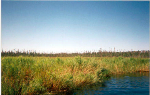
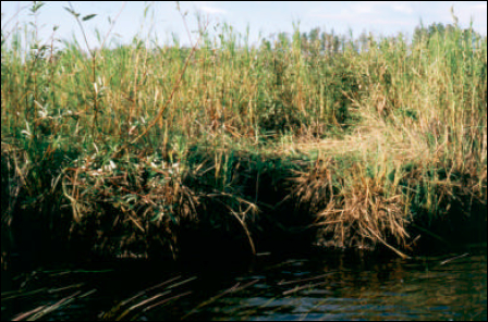
Figure 4: View of the fen from the river
4.0 Implementation
Implementation of this Statement of Conservation Interest will primarily involve monitoring activities to ensure adherence to the management guidelines and responding to inquiries about the site.
Implementation of this statement and management of the reserve are the responsibility of the Ignace Area Supervisor. Partnerships may be pursued to address management needs.
5.0 Review and revisions
This Conservation Reserve Statement of Conservation Interest will be reviewed on an ongoing basis.
If changes in management direction are needed at any time, the significance of the changes will be evaluated and further consultation a possibility. Any major amendments will require full public consultation and the approval of the District Manager and Regional Director. Affected clients will be immediately informed of proposed changes to this Statement of Conservation Interest.
This Statement of Conservation Interest complies with all requirements of the Environmental Assessment Act and the Environmental Bill of Rights.
5.2 Public consultation
5.2.1 Results of past consultations
Consultation on the Gulliver River Conservation Reserve was conducted as part of the consultation on the Ontario’s Living Legacy Land Use Strategy, July 1999. Subsequent consultation also took place in August of 2000 to refine the boundary of the Conservation Reserve.
District Manager letters, totaling 94, were sent to the Dryden Forest Management Co., Tourist Outfitters, Advisory Committees, Trappers, Land Owners, Members of the Public, NGOs and GOs. Newspaper ads were placed in the Ignace Driftwood on August 9, 2000 and Dryden Observer on August 15 and 22, 2000.
First Nation Consultation letters were also sent to ten Native communities including the Ojibway Nation of the Saugeen Band, Wabigoon Lake Ojibway Nation and Aboriginal People of Wabigoon. Direct consultation with Treaty 3 First Nations is being carried out on a regional basis and is ongoing.
No responses have been received to date from any of the above mentioned organizations/groups.
5.2.2 Present and future consultation
More widespread consultation is not deemed necessary at this time.
5.2.3 Author
This Statement of Conservation Interest was prepared by Alicia H.L. Morin, OLL Intern, Information Management, Dryden District. Assistance was provided by Martin Pell (Dryden District), Jim Cameron (Thunder Bay Regional) and members of the Ignace Area Team.
6.0 References
Northern Bioscience. Earth Science Inventory for Gulliver River Conservation Reserve. 2001.
Northern Bioscience. Life Science Inventory for Gulliver River Conservation Reserve. 2001.
Ontario’s Living Legacy Land Use Strategy, 1999. p. 24. Queen’s Printer for Ontario.
Ontario Ministry of Natural Resources. Gulliver River Conservation Reserve (C2292) Fact Sheet. August 2000.
Ontario Ministry of Natural Resources. Gulliver River Conservation Reserve (C2292) Recreation Resource Inventory Report. 2002.
Ontario Ministry of Natural Resources, Lands & Natural Heritage, Lands & Waters. Conservation Reserve Policy and Procedure PL 3.03.05. February, 1997. 22 pp.
Appendix C: Life Science Reconnaissance Survey
C2292 Gulliver River
Natural Heritage Area – Life Science Checksheet
| Name | C2292 Gulliver River |
|---|---|
| Map Name | Bonheur |
| Map Number | 52G/6 |
| UTM Reference | Zone 16 E 61400 N 545700 |
| County | Kenora District |
| Latitude | 49° 15' N |
| Longitude | 91° 25" W |
| NAD | 83 |
| Minimum Altitude | 450 m |
| Maximum Altitude | 500 m |
| Locality | 20 km southeast of Ignace |
| Township | Gummet, Dewan, Cathcart |
| Area | 2,780 ha |
| Ownership | Crown |
| MNR Region | Northwest |
| Ecoregion and Ecodistrict | 3W-2 |
| Landform Unit | See Table 4 |
| MNR District | Dryden |
| Aerial Photographs Year-Roll-Flight Line-Numbers |
1996-5/4908B/12-18 1996-35/4910B/112-119 |
Map: C2292 Gulliver River
Physical and biological features
The Gulliver River Conservation Reserve encompasses 2780 ha of aeolian and outwash deposits in Site District 3W-2. The topography is generally flat to gently rolling. Upland forests with jack pine-dominated conifer and mixedwood forest (ES13,14,16) make up 45% of the Conservation Reserve (Table 1). Ground moraine and bedrock-controlled terrain make up a small proportion of the site.
Most of the upland forest originated from a large 1936 burn. Soils are relatively shallow (50–60 cm deep) medium to fine sand over bedrock. Forested dunes in the southwest corner of the site are steep-sided elliptical hills made up of windblown medium to fine sand. Vegetation on the dunes is herb-and shrub-poor jack pine forest with reindeer lichens (Cladina spp.) and feathermosses (Pleurozium schreberi) (ES13). White pine and red maple are present in small numbers.
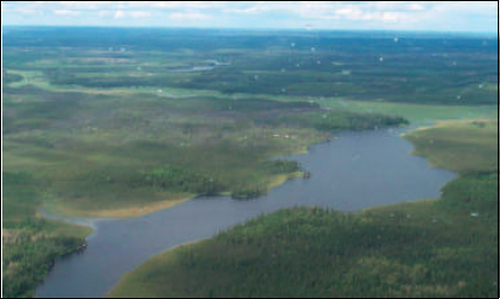
Open wetlands, consisting of fen, bog, meadow marsh, and shore fen, make up about 40% of the Conservation Reserve (Photo 1). Fens range from open saturated conditions dominated by sedges to semi-treed conditions with tamarack, sedges, and low shrubs. Bogs are restricted to sites isolated from groundwater flow and above the flood level of the Gulliver River. Bog vegetation includes small, scattered black spruce, ericaceous shrubs, and a Sphagnum carpet (ES34). A series of patterned fens extends through the Conservation Reserve where there is significant groundwater flow (ES43). The best-developed patterned fen near the west end of the Conservation Reserve has a distinctive pattern of linear ridges and pools evident on aerial photographs. Vegetation is dominated by sedges and low shrubs with plant indicators of mineral-rich conditions, including shrubby cinquefoil, starved sedge, livid sedge and Hudsonian clubrush. Rich indicators decline farther from the main groundwater flow. Shore fen (ES45) and meadow marsh (ES46) with dense grass and sedge cover dominate the floodplain of the Gulliver River.
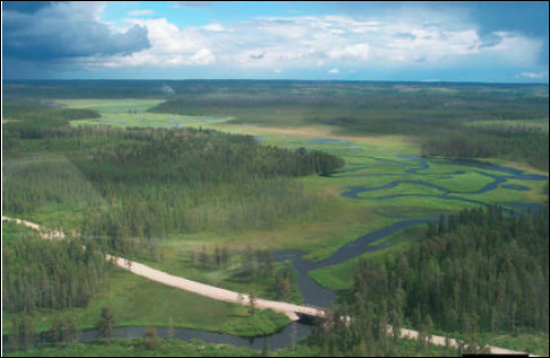
The Gulliver River is a well-developed meandering system, complete with channel cutting and point bar deposition, channel levees, extensive floodplain, and abandoned meanders (Photo 2,3).
About 4% of the Conservation Reserve (121 ha) was burned in 1995.
Representation
The Conservation Reserve contains representative examples of fen and bog communities on outwash sand. Similar wetland types are also represented in the Trewartha Creek Conservation Reserve. Mature jack pine dominated forest on aeolian and outwash sand is also well-represented (Table 3). (Note that Site District boundaries changed in 1999. Revised boundaries were not available for the landform vegetation summary presented in Table 3).
Condition
Approximately 7% (188 ha) of the Conservation Reserve was cutover in the early 1990's. Cutovers occur in several discrete areas along the north and east sides of the Reserve. Secondary logging roads enter the Reserve at five or six points. At least some of the roads are still passable to vehicle traffic.
There is no evidence of human disturbance in the wetlands or on the Gulliver River.
Diversity
The Gulliver River Conservation Reserve has relatively low diversity on the landscape scale, being dominated by aeolian and outwash landforms. Wetlands contribute to the diversity with a range of peatland communities.
Ecological considerations
The Conservation Reserve includes a small area of mature jack pine-dominated forest with a high degree of edge habitat. As logging proceeds around the Conservation Reserve, area-sensitive forest interior species may decline as forest fragmentation increases.
The relatively small upland area is vulnerable to being burned over completely in a large fire originating off the Conservation Reserve.
The patterned fen community depends on groundwater flow from outside the Conservation Reserve. Land practices outside the Conservation Reserve that disrupt groundwater movement could impair the function of the fen.
Special features
The rich patterned fen is globally rare community type according to Nature Conservancy rankings (G2). This ranking may underestimate the abundance of the peatlands in northwestern Ontario and in the Hudson Bay Lowlands. The fens in Gulliver River are nonetheless easily accessible, pristine examples of this boreal community type. Some plant species associated with this community, including starved sedge, livid sedge and Michaux’s sedge, are restricted to rich fen habitats and are uncommon to rare in northwestern Ontario.
Marsh rush was discovered in the rich fen. This northern species is restricted to large, rich fens and very local in northwestern Ontario. Other plants of limited distribution in northwestern Ontario include water shield, tawny cottongrass, and floating clubrush.
Several sharp-tailed grouse were seen in a cutover at the west end of the Conservation Reserve. This species is considered to be regionally rare in Site Region 3W. Sharp-tailed grouse probably nest in the Conservation Reserve. Leks (courtship dancing grounds) may occur in the open patterned fen, since they have been documented at other open peatlands in the area.
A provincially rare dragonfly, zigzag darner (Aeshna sitchensis: S1S3) is locally common in the open fen communities (Photo 4). This species is apparently found only in large peatlands in boreal areas in northern Ontario.
The dense graminoid cover of the extensive meadow marsh and shore fen on the Gulliver River floodplain may provide habitat for yellow rails (Coturnicops noveboracensis). The conservation status of yellow rail in Ontario is currently under review.
Significance level and summary of major representative values
The Gulliver River Conservation Reserve is provincially significant due to "critical" representation of a number of landform vegetation types (Table 3). The site contains regionally significant examples of patterned fen and forested dunes. The upland jack pine forest on aeolian and outwash sand is representative of Site District 3W-2.
Recommendations
- Expand the Conservation Reserve to include the patterned peatland 600 m north of the northeast boundary (see map).
- Adjust the south boundary to include the entirety of the open peatlands currently bisected by the boundary (see map).
- Develop a plan to maintain or rehabilitate existing logging roads in the Conservation Reserve.
- Ensure that any necessary silviculture is applied to regenerate forests on the cutovers within the Reserve.
Major information sources
Harris, A.G., S.C. McMurray, P.W.C. Uhlig, J.K. Jeglum, R.F.Foster and G.D. Racey. 1996. Field guide to the wetland ecosystem classification for northwestern Ontario. Ontario Ministry of Natural Resoures, Northwest Science & Technology. Thunder Bay, Ontario. Field Guide FG-01. 74 pp. + Append.
OMNR. 1999. Ontario’s Living Legacy – Land Use Strategy. Queen’s Printer, Toronto.
Proctor and Redfern Group. 1984. Peat and peatland evaluation of the Ignace area. 6 Volumes. Ontario Geological Survey. Open File Report 5487.
Racey, G.D., A.G. Harris, J.K.Jeglum, R.F.Foster and G.M.Wickware. 1996. Terrestrial and wetland ecosites of northwestern Ontario. Ontario Ministry Natural Resoures, Northwest Sci. & Technol. Thunder Bay, Ontario. Field Guide FG-02. 88 pp. + Append.
Sims, R.A., W.D. Towill, K.A. Baldwin, P. Uhlig and G.M. Wickware. 1997. Field guide to the forested ecosystem classification for northwestern Ontario. Ont. Min. Natur. Resour., Northwest Sci. & Technol. Thunder Bay, Ont. Field Guide FG-03. 176 p.
Date Compiled:
January 2002
Compilers:
Allan Harris and Robert Foster, Northern Bioscience
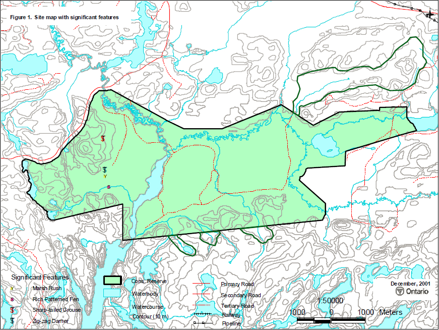
Figure 1: Site map with significant features
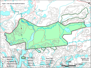
Enlarge Figure 1: Site map with significant features
Photo 1 . Open wetlands make up 40% of the Conservation Reserve.
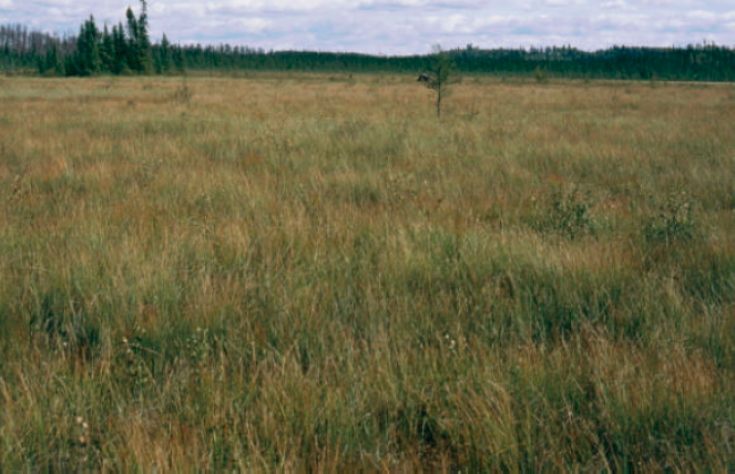
Photo 2 . The Gulliver River channel is undergoing active erosion and deposition where it passes through aeolian sand deposits.
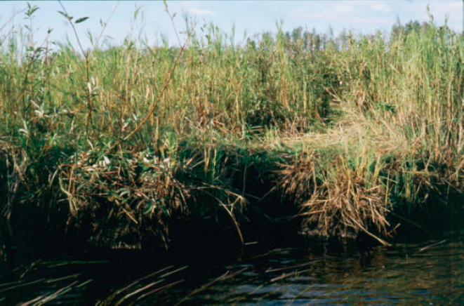
Photo 3 . Gulliver River floodplain.
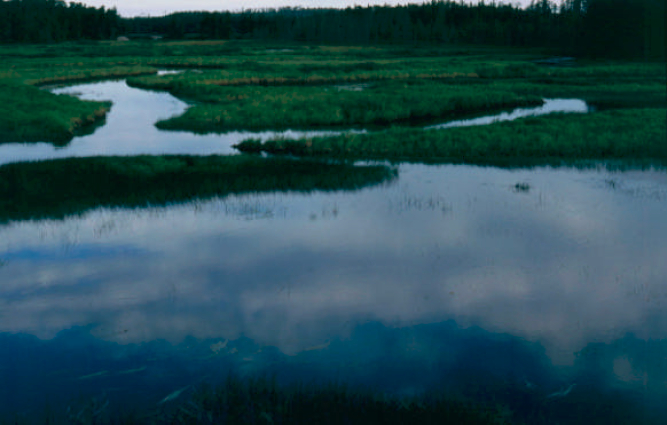
Photo 4 . Zigzag darner, a provincially rare dragonfly, is common in open fens.
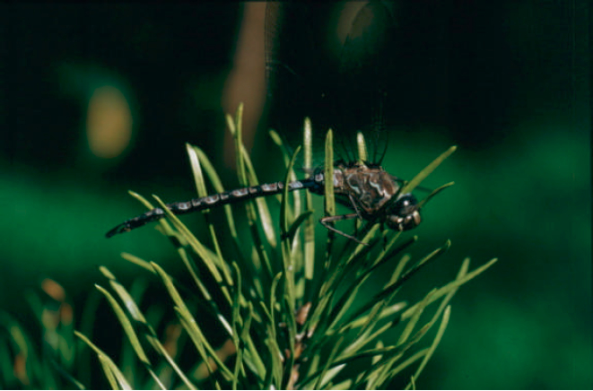
Table 1. Land cover classes of Gulliver River Conservation Reserve (derived from Landsat data).
| Landcover Class | Area (ha) | % of Site |
|---|---|---|
| Water | 111 | 4 |
| Open Fen | 155 | 6 |
| Treed Fen | 80 | 3 |
| Open Bog | 82 | 3 |
| Treed Bog | 715 | 26 |
| Dense Deciduous Forest | 24 | 1 |
| Dense Coniferous Forest | 861 | 31 |
| Mixed Forest -mainly Deciduous | 23 | 1 |
| Mixed Forest -mainly Coniferous | 308 | 11 |
| Sparse Coniferous Forest | 96 | 3 |
| Sparse Deciduous Forest | 16 | 1 |
| Recent Cutovers | 188 | 7 |
| Recent Burns | 121 | 4 |
| Totals | 2780 | 100 |
Table 2. Rapid assessment plot summary from Gulliver River Conservation Reserve.
| Plot No. | V/W Type | ES Type | Date |
|---|---|---|---|
| 74 | W27 | ES35 | 09/04/2001 |
| 75 | W17 | ES43 | 09/04/2001 |
| 76 | W19 | ES42 | 09/04/2001 |
| 77 | W22 | ES40 | 09/04/2001 |
| 79 | V19 | ES14 | 09/04/2001 |
| 71 | W25 | ES34 | 09/04/2001 |
| 78 | V30 | ES13 | 09/04/2001 |
| 73 | V11 | ES16 | 09/04/2001 |
| 72 | V32 | ES13 | 09/04/2001 |
| 70 | W22 | ES40 | 09/04/2001 |
| 69 | W14 | ES45 | 09/04/2001 |
| 68 | V30 | ES12 | 09/04/2001 |
| 67 | W13 | ES46 | 09/04/2001 |
Table 3. Landform – vegetation (LV) type representation for Gulliver River Conservation Reserve.
| Site Region* | Landform | Surface Expression | Burn | Conifer | Conifer Mixed | Deciduous | Deciduous Mixed | Open Wetland | Spares Forest | Grand Total |
|---|---|---|---|---|---|---|---|---|---|---|
| 3W-2 | Beach and Aeolian Deposits | moderately broken | 6 | 118R | 39 | 14R | 7R | 144 | 22C | 350 |
| 3W-2 | Outwash Deposits | moderately broken | 41 | 536 | 159C | 10 | 6R | 480R | 89 | 1321 |
| 3W-2 | Outwash Deposits | weakly broken | 5 | 266R | 37R | 2R | 0 | 274C | 2 | 586 |
| Total | 52 | 920 | 235 | 26 | 13 | 898 | 113 | 2257 |
Table 4. Site type matrix for Gulliver River Conservation Reserve.
| Description | Arid | Very Dry | Dry | Dry Mesic | Mesic | Wet Mesic | Wet | Very Wet | Saturdated | Open Water |
|---|---|---|---|---|---|---|---|---|---|---|
| Colder Rock | ||||||||||
| Colder Sand | ||||||||||
| Colder Loam | ||||||||||
| Colder Clay | ||||||||||
| Colder Organic | ES35, ES40, ES42, ES43 | ES35, ES40, ES42, ES43 | ES45 | |||||||
| Normal Rock | ||||||||||
| Normal Sand | ES13, ES14, ES16 | ES13, ES14, ES16 | ||||||||
| Normal Loam | ||||||||||
| Normal Clay | ||||||||||
| Normal Organic | ||||||||||
| Warmer Rock | ||||||||||
| Warmer Sand | ||||||||||
| Warmer Loam | ||||||||||
| Warmer Clay | ||||||||||
| Warmer Organic |
Gulliver River Conservation Reserve species lists
The following species lists are based fieldwork conducted September 4 2001 and data provided by OMNR.
Plant list
Taxonomic order and species names generally follow Morton and Venn (1990). Introduced species are marked "I". Provincially rare species (Oldham 1999) are marked "P". Voucher specimens were collected for species marked "*".
| Family Equisetaceae | Horsetail Family |
|---|---|
| Equisetum sylvaticum L | Woodland Horsetail |
| Family Dennstaetiaceae | Bracken Family |
|---|---|
| Pteridium aquilinum (L.) Kuhn | Bracken |
| Family Lycopodiaceae | Clubmoss Family |
|---|---|
| Lycopodium annotinum L | Bristly Clubmoss |
| Lycopodium clavatum L. | Common Clubmoss |
| Lycopodium obscurum L. | Flat-branched Tree Clubmoss |
| Family Pinaceae | Pine Family |
|---|---|
| Picea mariana (Miller) BSP | Black Spruce |
| Pinus banksiana Lambert | Jack Pine |
| Pinus strobus L. | White Pine |
| Family Alismataceae | Water Plantain Family |
|---|---|
| Sagittaria latifolia Willd | Broad-leaf Arrowhead |
| Family Cyperaceae | Sedge Family |
|---|---|
| Carex buxbaumii Wahlenb. | Buxbaum’s Sedge |
| Carex exilis Dewey | Starved Sedge |
| Carex lacustris Willd. | Lake Sedge |
| Carex lasiocarpa Ehrh. | Wire Sedge |
| Carex limosa L. | Mud Sedge |
| Carex livida (Wahlenb.) Willd. | Livid Sedge |
| Carex magellanica ssp. irrigua Lam. | Quaking Sedge |
| Carex michauxiana Boeckeler | Michaux’s Sedge |
| Carex oligosperma Michaux | Few-seeded Sedge |
| Carex pauciflora Light. | Few-flowered Sedge |
| Carex rostrata Stokes | Beaked Sedge |
| Carex trisperma var. trisperma Dewey | Three-fruited Sedge |
| Dulichium arundinaceum (L.) Britton | Three-way Sedge |
| Eleocharis smallii Britton | Marsh Spikerush |
| Eriophorum vaginatum (Fern.) Hulten | Dense Cottongrass |
| Eriophorum virginicum L. | Tawny Cottongrass |
| Rhynchospora alba (L.) M.Vahl | White Beakrush |
| Scirpus cespitosus L. | Tufted Club Rush |
| Scirpus cyperinus (L.) | Kunth Black-sheathed Bulrush |
| Scirpus hudsonianus (Michaux) Fern. | Hudsonian Club Rush |
| Scirpus subterminalis Torrey | Floating Clubrush |
| Family Juncaceae | Rush Family |
|---|---|
| Juncus brevicaudatus (Engelm.) Fern. | Short-tailed Rush |
| Juncus stygius L. | Marsh Rush |
| Family Liliaceae | Lily Family |
|---|---|
| Clintonia borealis (Aiton) Raf. | Blue Bead Lily |
| Maianthemum canadense Desf. | Wild Lily-of-the-valley |
| Maianthemum trifolium (L.) Sloboda | Three-leaved Solomon’s Seal |
| Streptopus roseus Michaux | Rose Twisted Stalk |
| Family Poaceae | Grass Family |
|---|---|
| Calamagrostis canadensis (Michaux) P.Beauv. | Bluejoint Grass |
| Calamagrostis stricta ssp. inexpansa (A. Gray) C.W. Greene | Northern Reed Grass |
| Cinna latifolia (Trevir. ex Goeppinger) Griseb. in Ledeb. | Drooping Woodreed |
| Glyceria canadensis (Michaux) Trin. | Rattlesnake Manna Grass |
| Muhlenbergia glomerata (Willd.) Trin. | Marsh Muhly |
| Family Potamogetonaceae | Pondweed Family |
|---|---|
| Potamogeton natans L. | Floating-leaved Pondweed |
| Family Scheuchzeriaceae | Pod-Grass Family |
|---|---|
| Scheuchzeria palustris L. | Pod-grass |
| Family Sparganiaceae | Bur-reed Family |
|---|---|
| Sparganium natans L. | Least Bur-reed |
| Family Typhaceae | Cattail Family |
|---|---|
| Typha latifolia L. | Common Cattail |
| Family Aceraceae | Maple Family |
|---|---|
| Acer rubrum L. | Red Maple |
| Acer spicatum Lam. | Mountain Maple |
| Family Araliaceae | Ginseng Family |
|---|---|
| Aralia hispida Vent. | Bristly Sarsaparilla |
| Family Asteraceae | Sunflower Family |
|---|---|
| Anaphalis margaritacea (L.) Benth. & Hook. f.ex C.B. Clarke |
Pearly Everlasting |
| Aster borealis (Torrey & A.Gray) Prov. | Rush-leaved Aster |
| Aster lanceolatus Willd. | Panicled Western Aster |
| Aster macrophyllus L. | Large-leaved Aster |
| Solidago hispida Muhlenb. | Upland Goldenrod |
| Solidago uliginosa Nutt. | Marsh Goldenrod |
| Family Betulaceae | Birch Family |
|---|---|
| Alnus incana (L.) Moench | Speckled Alder |
| Alnus viridis (Chaix) DC. | Green Alder |
| Betula pumila L. | Dwarf Birch |
| Family Cabombaceae | Water Shield Family |
|---|---|
| Brasenia schreberi J. Gmelin | Water Shield |
| Family Caprifoliaceae | Honeysuckle Family |
|---|---|
| Diervilla lonicera Miller | Bush Honeysuckle |
| Linnaea borealis L. | Twinflower |
| Family Cornaceae | Dogwood Family |
|---|---|
| Cornus canadensis L. | Bunchberry |
| Family Ericaceae | Heath Family |
|---|---|
| Andromeda polifolia L. | Bog Rosemary |
| Chamaedaphne calyculata (L.) Moench | Leatherleaf |
| Gaultheria hispidula (L.) Muhlenb . ex Bigelow | Creeping Snowberry |
| Kalmia polifolia Wangenh. | Bog Laurel |
| Ledum groenlandicum Oeder | Labrador Tea |
| Vaccinium angustifolium Aiton | Low Blueberry |
| Vaccinium myrtilloides Michaux | Velvet-leaved Blueberry |
| Vaccinium vitis-idaea L. | Rock Cranberry |
| Family Fumariaceae | Fumitory Family |
|---|---|
| Corydalis sempervirens (L.) Pers. | Pale Corydalis |
| Family Guttiferae | St. John’s-wort Family |
|---|---|
| Hypericum ellipticum Hook. | Pale St. Johnswort |
| Family Lentibulariaceae | Bladderwort Family |
|---|---|
| Utricularia intermedia Hayne | Flat-leaved Bladderwort |
| Family Menyanthaceae | Bogbean Family |
|---|---|
| Menyanthes trifoliata L. | Buckbean, Bogbean |
| Family Myricaceae | Bayberry Family |
|---|---|
| Myrica Gale L. | Sweet Gale |
| Family Onagraceae | Evening-primrose |
|---|---|
| Epilobium angustifolium L. | Fireweed |
| Family Primulaceae | Primrose Family |
|---|---|
| Lysimachia thyrsiflora L. | Tufted Loosestrife |
| Family Rhamnaceae | Buckthorn Family |
|---|---|
| Rhamnus alnifolia L'Her. | Alder-leaved Buckthorn |
| Family Rosaceae | Rose Family |
|---|---|
| Potentilla fruticosa L. | Shrubby Cinquefoil |
| Potentilla palustris (L.) Scop. | Marsh Cinquefoil |
| Prunus pensylvanica L.f. | Pincherry |
| Rubus chamaemorus L. | Cloudberry, Bakeapple |
| Rubus idaeus L. | Common Raspberry |
| Spiraea alba Duroi | Narrow-leaved Meadow Sweet |
| Family Salicaceae | Willow Family |
|---|---|
| Salix pedicellaris | Pursh Bog Willow |
| Salix planifolia Pursh | Flat Leaf Willow |
| Family Sarraceniaceae | Pitcher Plant Family |
|---|---|
| Sarracenia purpurea L. | Pitcher Plant |
Gulliver River Conservation Reserve Animal Species List
Taxonomic order and nomenclature follow AOU (1998) for birds and Banfield (1974) for mammals.
Birds
| Family Phasianidae | Grouse, Turkeys and Quail |
|---|---|
| Tympanuchus phasianellus | Sharp-tailed Grouse |
| Family Picidae | Woodpeckers |
|---|---|
| Picoides arcticus | Black-backed Woodpecker |
| Colaptes auratus | Northern Flicker |
| Family Corvidae | Jays, Crows and Ravens |
|---|---|
| Cyanocitta cristata | Blue Jay |
| Corvus brachyrhynchos | American Crow |
Mammals
| Family Cervidae | Deer |
|---|---|
| Alces alces | Moose |
Appendix B: Earth Science Reconnaissance Survey
Detailed section
Protection history
Gulliver River Conservation Reserve (C2292) was first identified for protection under the Ontario’s Living Legacy Land Use Strategy (1999). This site partly overlaps an area identified by Noble (1978).
Setting
This area contains broad, rolling hills, separated by flat-bottomed river valleys and wetlands. The Gulliver River passes through the northwest part of the site. Logging of parts of this site has taken place in the past.
Earth science features
Bedrock: This site is within a granitic terrane of the Wabigoon Subprovince of the Archean-aged Superior Province. Outcrops of foliated to gneissic tonalite were observed during field reconnaissance both as shoreline exposures along the banks of the Gulliver River, and as linear outcrop ridges (good exposure in cutover in the southwest corner of the conservation reserve) surrounding the river and wetlands. Each outcrop studied also contained mafic clots, probably related to the protolith of the tonalite, as well as undeformed granitic pegmatite dikes cross cutting the country rock and intruding coplanar with major joint sets. Faulting appears to be common within this site (generally oriented northwest/southeast and steep), and play a significant role in the shape and orientation of landscape features.
Surficial: The most prominent Pleistocene-aged deposits within this site are beach, delta, aeolian and outwash sands. Exposures of unconsolidated Pleistocene-aged material were not observed within the reserve during the survey, although landforms characteristic of aeolian dunes were encountered in the southwest part of the site. The dunes are expressed as low, elongate hills, and are densely vegetated. There is a location where a dune form has been exposed approximately 10 m outside the west site boundary, and its aeolian nature was confirmed by common frosted quartz grains within the well-sorted but relatively unstructured sand. The windblown fine-medium sand was probably derived from outwash plain material related to the ablation of the ice front that was forming the Hartman Moraine to the north. Dredge and Cowen (1989) consider glacial lake Agassiz to have extended right to the ice front during the Algonquin Stadial environment of Davidson (1981), and therefore the aeolian transport of the sand must have occurred following the withdrawal of Lake Agassiz from the area, but prior to establishment of vegetation. The waters of glacial Lake Agassiz moved from this region during its Nipigon or Ojibway phases (Dredge and Cowen, 1989).
More recently, extensive peat accumulation began in many wetland areas within this site, a process which continues today. The Gulliver River, an active meandering system (Plate 1), is exceptionally well-developed (Fluvial Land Forms Processes and Environments of Davidson, 1981). Well-defined channels with outside cutting (Plate 2) and point bar deposition, channel levees, flood plain landforms and deposits, and abandoned channel scars are easily recognizable from maps and air photos. The fact that the river is somewhat confined to its current floodplain by bedrock ridges to the south and moraine/outwash to the north probably enhances the long-term stability and development of the system.
Sensitivity
The dune areas and the Gulliver River system are particularly susceptible to disturbance. In the case of the dune forms, a striking example of this sensitivity can be found in along the forest access road (west boundary) where one such dune has been exposed by road building and harvesting, and has re-activated as an aeolian system and is currently undergoing active transport. The Gulliver River has achieved an equilibrium of sorts with both water discharge and sediment load which has led to the preservation of textbook meandering river features. Any disruption in flow or sediment load would likely lead to a deterioration of this balance.
Significance
Most of the earth science features represented in this site are found elsewhere, although the landforms associated with forested dunes and active meandering streams are regionally exceptional examples.
Recommendations
Further road development and harvesting is not recommended within or adjacent to both the Gulliver River and the dune forms in the southwest section of the site. These practices would certainly harm the integrity of these features. The dunes, while well anchored by vegetation, are particularly sensitive to disruption by both foot and motorized travel, and therefore these activities should be restricted on and around them.
References
Davidson, R.J. 1981. A framework for the conservation of Ontario’s earth science features. Ontario Ministry of Natural Resources, Toronto, 262 pp.
Dredge, L.A and Cowen, W.R. 1989. Quaternery geology of the Southwestern Canadian Shield. In: Fulton, R.J. (ed); Quaternery geology of Canada and Greenland, Geology of Canada, no.1, Canadian Geological Survey, Ottawa, 839 pp.
Noble, T.W. 1978. Life science report Phase II. Site Region 4W. North Central Region. Unpublished report
Plate 1: Several meanders and abandoned channels on the Gulliver River
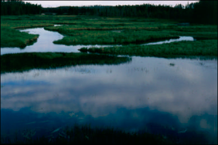
Plate 2: Channel-cut bank on Gulliver River
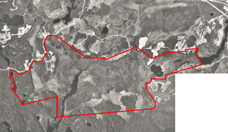
Appendix B: Gulliver River Conservation Reserve (C2292) – Aerial photo image
This picture is illustrative only. Do not rely on it as being a precise indicator of boundaries, routes, locations of features, nor as a guide for navigation.
Published March, 2002
Appendix A: Gulliver River Conservation Reserve map
Map: C2292 – Gulliver River Conservation Reserve
Enlarge Map: C2292 – Gulliver River Conservation Reserve
Policy Report (revised July 20, 2001)
NEWID: C2292/ IG7 District: Dryden Region: Northwest
Identification:
ID: C2292
Area Name: Gulliver River
Area (ha): 2784
Land Use: Conservation Reserve
Category: N/A
Description:
This site contains representative landform and vegetation types, including mixed forests on moderately broken beach and aeolian deposits and wetlands on moderately broken outwash.
Land use intent:
The intent is to regulate this area as a Conservation Reserve.
Management of this area is also governed by the general policies contained in Land Use Strategy (1999)
Management direction:
Those uses and management activities not listed in the following table are governed by existing Conservation Reserve policy. Over time the management direction will be elaborated in a Statement of Conservation Interest or Resource Management Plan. Any new uses, and commercial activities associated with them, will be considered on a case by case basis, and they must pass a test of compatibility to be acceptable. Compatibility is normally determined through a planning process.
Commercial activities
| Activity | Permitted | Guidelines |
|---|---|---|
| Aggregate Extraction: | No | N/A |
| Bait Fishing Existing: | Yes | Existing use permitted to continue, unless there are significant demonstrated conflicts. |
| Bait Fishing New | Maybe | New operations can be considered, subject to the "test of compatibility". |
| Commercial Fishing Existing: | Yes | Existing use permitted to continue, unless there are significant demonstrated conflicts. |
| Commercial Fishing New: | Maybe | New operations can be considered, subject to the "test of compatibility". |
| Commercial Fur Harvesting Existing: | Yes | Existing use permitted to continue, unless there are significant demonstrated conflicts. Existing trap cabins can continue |
| Commercial Fur Harvesting New: | Maybe | New cabins are not permitted. New operations can be considered, subject to the "test of compatibility". |
| Commercial Hydro Development: | No | N/A |
| Commercial Timber Harvest: | No | N/A |
| Commercial Tourism Existing: | Yes | Existing authorized facilities can continue, unless there are significant demonstrated conflicts. |
| Commercial Tourism New: | Maybe | New tourism facilities can be considered during the planning for an individual reserve. |
| Bear Hunting by Non-residents (guided) Existing: | Yes | Existing authorized operations permitted to continue. |
| Bear Hunting by Non-residents (guided) New: | No | New operations not permitted. |
| Outfitting Services Existing: | Yes | Existing authorized operations permitted to continue. |
| Outfitting Services New: | Maybe | New operations can be considered during the planning for an individual reserve. |
| Outpost Camps Existing: | Yes | Existing authorized operations permitted to continue. |
| Outpost Camps New: | Maybe | New operations can be considered during the planning for an individual reserve. |
| Resorts/lodges Existing: | Yes | Existing authorized facilities permitted to continue. |
| Resorts/lodges New: | Maybe | New facilities can be considered during the planning for an individual reserve. |
| Energy Transmission and Communications Corridors Existing: | Yes | These facilities should avoid conservation reserve lands wherever possible. |
| Energy Transmission and Communications Corridors New: | No | These facilities should avoid conservation reserve lands wherever possible. |
| Food Harvesting (Commercial) Existing: | Maybe | N/A |
| Food Harvesting (Commercial) New: | Maybe | N/A |
| Mineral Exploration and Development: | Maybe | Mineral exploration may occur under controlled conditions in portions of new conservation reserves that are identified through further analysis and consultation as having provincially-significant mineral potential. If a site is to be developed for a mine, it would be deregulated as part of the reserve, and a replacement area added to the reserve. |
| Peat Harvesting: | No | |
| Wild Rice Harvesting: Existing: |
Yes | |
| Wild Rice Harvesting: New: |
Maybe |
Land and resource management activities
| Activity | Permitted | Guidelines |
|---|---|---|
| Crown Land Disposition Private Use: | Maybe | Sale of lands is not permitted, except for minor dispositions in support of existing uses (e.g., reconstruction of a septic system). Renewals of existing leases and land use permits are permitted. Requests for transfer of tenure will be considered in the context of the Statement of Conservation Interest or Resource Management Plan. New leases or land use permits permitted for approved activities. Tourism facilities can apply to upgrade tenure from LUP to lease. |
| Crown Land Disposition Commercial Use: | Maybe | Sale of lands is not permitted, except for minor dispositions in support of existing uses (e.g., reconstruction of a septic system). Renewals of existing leases and land use permits are permitted. Requests for transfer of tenure will be considered in the context of the Statement of Conservation Interest or Resource Management Plan. New leases or land use permits permitted for approved activities. Tourism facilities can apply to upgrade tenure from LUP to lease. |
| Fire Suppression: | Yes | Fire suppression policies are similar to adjacent Crown lands, unless alternative fire policies have been developed through a planning process. |
| Fish Habitat Management: | Maybe | |
| Fish Stocking Native Species: | Maybe | Conservation Reserves policy indicates that "featured species management" may be permitted. |
| Fish Stocking Non-native Species: | No | No explicit guidelines are included on fish stocking. |
| Insect/disease Suppression: | Maybe | |
| Inventory/Monitoring: | Yes | |
| Personal use permits for Wood Harvesting: | Maybe | Existing permits may continue on an interim basis for properties that do not have road access. The long term status will be determined through management planning. |
| Prescribed Burning: | Maybe | |
| Roads (Resource Access) Existing: | Yes | Existing roads can continue to be used. Continued use will include maintenance and may include future upgrading. |
| Roads (Resource Access) New: | Maybe | New roads for resource extraction will not be permitted, with the exception of necessary access to existing forest reserves for mineral exploration and development, or where part of a conservation reserve has been formally identified as having provincially significant mineral potential that is open for controlled exploration. |
| Vegetation Management: | Maybe | Conservation Reserves policy indicates that Featured Species Management and Natural Systems Management may be permitted. Vegetation management can be considered in a planning process. |
| Wildlife Population Management: | Maybe |
Science, education and heritage appreciation
| Activity | Permitted | Guidelines |
|---|---|---|
| Collecting: | No | |
| Historical Appreciation: | Yes | |
| Nature Appreciation: | Yes | |
| Photography and Painting: | Yes | |
| Research: | Yes | |
| Wildlife Viewing: | Yes |
Recreation activities and facilities
| Activity | Permitted | Guidelines |
|---|---|---|
| All Terrain Vehicle Use On Trails: | Yes | Existing use permitted to continue where it does not adversely affect the values being protected. |
| All Terrain Vehicle Use Off Trails: | No | ATV use off trails is not permitted, except for direct retrieval of game. |
| Campgrounds: | Maybe | |
| Food Gathering: | Yes | |
| Horseback Riding (trail): | Yes | Existing use on trails permitted. |
| Hunting: | Yes | |
| Mountain Bike Use: | Yes | Existing use on trails permitted. |
| Motor Boat Use Commercial: | Yes | |
| Motor Boat Use Private: | Yes | |
| Non-motorized Recreation Travel: | Yes | |
| Private Recreation Camps (Hunt Camps) Existing: | Yes | Existing camps permitted to continue, and may be eligible for enhanced tenure, but not purchase of land. |
| Private Recreation Camps (Hunt Camps) New: | No | Existing camps permitted to continue, and may be eligible for enhanced tenure, but not purchase of land. |
| Rock Climbing: | Maybe | |
| Snowmobiling On Trails: | Yes | Existing use permitted to continue where it does not adversely affect the values being protected. |
| Snowmobiling Off Trails: | Maybe | Snowmobiling off trails is not permitted, except that snowmobiles may be used for direct retrieval of game. |
| Sport Fishing: | Yes | |
| Trail Development: | Maybe | Development of trails for a variety of activities (e.g., hiking, cross-country skiing, cycling, horseback riding, snowmobiling) can be considered as part of planning for an individual reserve. |
Note: The polices outlined in this table do not supersede any Aboriginal or treaty rights that may exist, or other legal obligations.
OLL Land Use Strategy, Table 4, and Conservation Reserves Policy.
Management of this conservation reserve is carried out within the context of conservation reserve policy as amended by the policies for new conservation reserves outlined in the OLL Land Use Strategy.
Source of direction:
LUS
Explanation of edits:
Potential revisions (for internal use only):
* Using old Site District boundaries
C critical to meet representation targets at the Site District level
R contributes to representation of the LV type at the Site District level