Halfway Lake Provincial Park Management Plan
This document provides direction on the management of Halfway Lake Provincial Park.
© 2002 Queen’s Printer for Ontario
Additional information about the park and copies of this publication are available at:
Ontario Ministry of Natural Resources,
Ontario Parks
199 Larch St., Suite 404,
Sudbury, Ontario, P3E 5P9
Halfway Lake Provincial Park
fax:
Price: $5.00 (payable to the Minister of Finance)
51242
(0.5k, 02 02 28)
ISBN 0-7778-8133-0
Cette publication est également disponible en français.
Approval statement
I am pleased to approve the Halfway Lake Park Management Plan as the official policy for the protection and management of this park. The plan reflects the Ministry of Natural Resources' and Ontario Parks' intent to protect the natural and cultural features of Halfway Lake Provincial Park and maintain and develop high quality opportunities for outdoor recreation and heritage appreciation for the residents of Ontario and visitors to the Province.
The plan includes an implementation strategy and a summary of the public consultation that occurred as part of the planning process.
The plan for Halfway Lake Provincial Park will be used to guide the management of the park. It may be reviewed to address changing issues or conditions. A review will be held after 10 years, or as required.
I wish to extend my sincere thanks to all those who participated in the public consultation process.
Yours truly,
Signed by:
Adair Ireland-Smith
Managing Director
Ontario Parks
Date:
December, 5, 2001
Statement of Environmental Values under the Environmental Bill of Rights
The Ministry of Natural Resources' Statement of Environmental Values (SEV) was prepared in accordance with the provisions of the Environmental Bill of Rights (EBR). It describes how the purposes of the EBR are to be considered whenever decisions are made which might significantly affect the environment.
The primary purpose of the EBR is "to protect, conserve and, where reasonable, restore the integrity of the environment". From the MNR's perspective, that broad statement of purpose translates into four objectives in its SEV:
- to ensure the long-term health of ecosystems by protecting and conserving our valuable soil, aquatic resources, forest and wildlife resources as well as their biological foundations
- to ensure the continuing availability of natural resources for the long-term benefit of the people of Ontario
- to protect natural heritage and biological features of provincial significance
- to protect human life, the resource base and physical property from the threats of forest fires, floods and erosion
The Ministry’s SEV has been considered throughout the preparation of this Management Plan. The Management Plan for Halfway Lake Provincial Park will further the objectives of managing Ontario’s resources on an ecologically sustainable basis.
1.0 Introduction
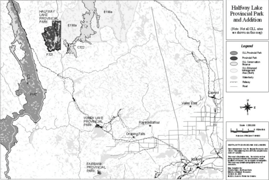
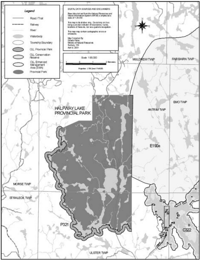
Halfway Lake Provincial Park is located approximately 90 kilometres northwest of Sudbury, along Highway 144 and 480 kilometres north of Toronto (Figure 1). The park lies on the southern edge of Canada’s boreal forest.
In 1980, the park was regulated under Ontario Regulation 250/80, Schedule 125. In 2000, the park addition (P321) identified in Ontario’s Living Legacy Land Use Strategy was regulated (O.Reg 685/00) as part of Halfway Lake Provincial Park.
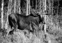
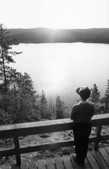
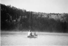
Halfway Lake Provincial Park, including the park addition (P321), comprises 5,113 hectares of the southern Canadian Shield. Some outstanding landform features within the park are periglacial boulder fields, rocky ridges, and numerous lakes and ponds. The vegetation is representative of the boreal forest, which is dominated by stands of jack pine generally mixed with trembling aspen, and white birch. Wildlife species are plentiful in the area and representative of the boreal forest environment. The park contains an extensive roadless area that has a full range of habitats to provide excellent conditions for moose. These northern giants are often seen from the park’s hiking trails or in marshy areas along the highway. Other mammals living in the park include wolf, lynx, fox, beaver and snowshoe hare. Over 90 species of birds have been identified in the park. This includes the great blue heron, a species that returns every year to rear its young. Osprey, bald eagle and broad-winged hawk also nest in the park. This boreal forest environment is a major attraction for visitors who enjoy a well serviced camping setting to engage in a variety of activities such as: angling, wildlife viewing, swimming, day-use hiking and sightseeing, boating and flatwater canoeing. The two campground loops contain 215 campsites. Highway travellers use the park as a convenient picnicking stopover.
The sandy beaches of Halfway Lake provided camping for the Ojibway Spanish River Band many years ago.
In the early 1900s, there was a logging camp on the shores of Halfway Lake. This camp was half way between the main logging area and the railway line where the logs were loaded for their trip to the sawmill. This is may be how Halfway Lake received its name.
2.0 Issues
2.1 Permitted uses
The park addition (P321), has some different management policies from the rest of the park. Ontario’s Living Legacy provides opportunities for sport hunting, fishing, bait fishing and fur harvesting to continue within this addition. (Section 8.1)
2.2 Adjacent land management
Forest management
Forest management operations are presently occurring adjacent to the parks' west boundary, which has resulted in the construction of secondary and tertiary roads along that boundary. New roads are being built on Crown lands west of the park. Prior to 1996 there were no roads adjacent to the west boundary of the park. (Section 8.8.3)
Unauthorized access
Unauthorized access via Highway 144 into Bailey Lake is difficult to manage. This unplanned use is affecting the park environment and its operations. Visitor conflicts occur when unauthorized use of sites interferes with park permit holders. (Section 8.8.4)
2.3 Fisheries
Representative sport fish species in the park include lake trout, bass and northern pike. The effects of year round fishing pressure on lake trout populations needs to be assessed. (Section 8.4)
Figure 1: Regional context

Enlarge Figure 1: Regional context
3.0 Classification
Halfway Lake Provincial Park is classified as a natural environment park in the Ontario Provincial Parks System (one of six classes of Ontario’s Provincial Parks). Ontario Provincial Park Policy (1992), states:
"Natural environment parks incorporate outstanding recreational landscapes with representative natural features and historical resources to provide high quality recreational and educational experiences."
4.0 Goal
The goal for Halfway Lake Provincial Park is:
"To protect and manage the parks outstanding recreational landscapes with representative natural features of the southern boreal forest while providing high quality recreational and educational experiences."
5.0 Objectives
The management and operation of Halfway Lake Provincial Park will contribute to:
"The achievement of Ontario Provincial Park objectives: protection, recreation, heritage appreciation, and tourism."
The objectives are described as follows:
5.1 Protection
"To maintain and manage the environment of the park to protect its natural, cultural, and recreational values."
All of the lands within Halfway Lake Provincial Park, like the rest of the Pre-Cambrian Shield, show signs of past glacial environments.
Today, the landforms of that ancient glacial time can be seen in the high, rolling hills and sculptured bedrock valleys that are partly covered in thin deposits of sandy till with pockets of water washed sands. East of Antrim Lake, in the park, is a pre-glacial boulder field. A remnant glacial feature, massive rounded rocks travelled here in a glacial river.
The park is on the southern edge of the boreal forest. Scattered tall white pine occur with the most common tree species in the park being the jack pine. Low areas contain sphagnum bogs with plant life such as bog laurel, three-leaved Solomon’s seal, sundew, pitcher plant, small- leaved cranberry and Labrador tea.
A life science survey, land and vegetation mapping and description, was completed for the site district around Halfway Lake. Zoning will identify representative areas where policies and management will recognize natural processes that sustain these features. (Section 7.0)
An ecological survey and a Vegetation Management Plan are required for the park to more fully describe plant communities, species and their significance. (Section 7.0, 8.2 & 11.1)
The 383 hectare park addition (P321) identified in Ontario’s Living Legacy Land Use Strategy contributes to the protection of landform, drainage, vegetation values and sensitive natural features.
5.2 Recreation
"To provide day-use opportunities in areas of outstanding recreational potential associated with natural environments." and,
"To provide facility-based camping opportunities in natural environments and in associated areas of outstanding recreational potential."
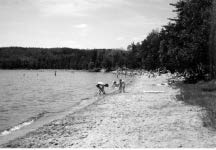
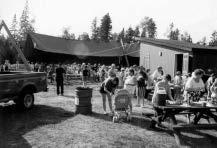
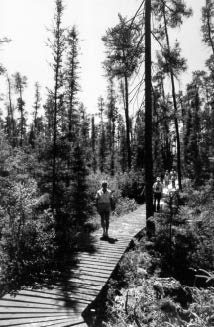
Day-use and campground camping are centered on the shores of Halfway Lake (Figure 4 & 5). The campgrounds provide a significant stopover and destination for travellers and vacationists. The beach and picnic area is a popular site for both day visitors and campers. The park offers picnicking, campground camping, swimming, angling, a hiking trail system ranging from four to thirty kilometres, backcountry camping and flatwater canoeing. Group camping and some recreation skills programs are also provided.
Halfway Lake Provincial Park has potential to supply additional backcountry travel and camping opportunities. The park’s extensive land base and lakes may support additional hiking and canoeing use.
As a result of these backcountry opportunities, an additional objective for the park will be:
"To provide natural environment backcountry camping opportunities."
Halfway Lake Provincial Park emphasizes natural environment based experiences that provide "individuals, families, and small groups with low-intensity contact with fellow recreationists". Recreational experiences could be "characterized by solitude, challenge, and personal integration with the natural environment."
The areas of the park best suited to satisfying the above recreation objectives are defined in Section 7.0 (zoning).
5.3 Heritage appreciation
"To provide opportunities for unstructured exploration and appreciation of the natural environment and heritage of the park." and,
"To provide opportunities for exploration and appreciation of natural and cultural environments through interpretation and education."
The natural and cultural heritage theme of the park and surrounding area is "Life at the Edge of the Boreal Forest." This theme represents the transition between the Great Lakes-St. Lawrence and the southern boreal forest. The park provides opportunities for both individual (self-guided) and structured (organized) interpretation to encourage the exploration and appreciation of the natural and cultural heritage in this park that contains representative features of Northern Ontario. Information concerning representative earth and life science features, historical resources, and other park values will be provided through the natural heritage education program in the form of leaflets, signs, exhibits, guided hikes and audiovisual presentations. (Section 9.1)
The park will continue to serve as a central point for interpreting natural and cultural themes in this area. Management will be directed at protecting these natural and cultural heritage values.
The existing interpretive resource centre, fosters appreciation for Northern Ontario’s natural and cultural heritage. The interactive displays allow the visitor to be introduced to "Life at the Edge of the Boreal Forest." The existing space is inadequate and crowded. The need for a larger Resource Centre will be accommodated. A proposed location for a new Resource Centre will be within the development zone. (Section 9.1.1, 9.5 & 10.4.1)
5.4 Tourism
"To provide Ontario residents and non- resident visitors with opportunities to discover and experience distinctive regions of the Province."
Halfway Lake Provincial Park provides day-use and camping opportunities to travellers in Ontario and destination camping opportunities to resident and non-resident travellers. The tourism thrust of the park will be to sustain use in a natural and scenic setting. The "Life at the Edge of the Boreal Forest" theme will be the main component to emphasize.
6.0 Park boundary
In 1980, Halfway Lake Provincial Park was regulated (O.Reg 250/80, Schedule 125 & 821/80, Schedule 125) under the Provincial Parks Act comprising 4,730 hectares of the southern Canadian Shield.
A park addition, identified as Halfway Lake Addition (P321) in Ontario’s Living Legacy Land Use Strategy (1999), consists of a 200 metre wide stretch along the western and southern portions of the park (Figure 2 & 3, NE3). In 2000, the Halfway Lake Addition was regulated (O.Reg 685/00) comprising 383 hectares bringing the parks' total area to 5,113 hectares. A description of this area (Section 5.1 & 7.3 NE3) and prevailing policies are provided in this Management Plan and Ontario’s Living Legacy Land Use Strategy (1999).
Figure 2: Park boundary
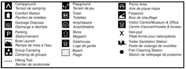
7.0 Zoning
Natural environment class parks may contain six possible land use zones: access, development, nature reserve, natural environment, historical and wilderness. Each zone permits certain land-uses and outlines park management strategies. The five types of zones that will guide the management and development of the park are: development, access, natural environment, nature reserve, and wilderness (Figure 3). Policies related to the park addition (P321) can be found in this Management Plan and Ontario’s Living Legacy Land Use Strategy (1999).
Interpretive, research, recreation, and operations facilities may be provided. Prescriptions will be prepared for each zone in the Park Operating Plan.
Ecological surveys will be required to describe life science values and to refine zoning (Section 5.1, 8.2, 9.2 & 11.1) and management prescriptions.
Figure 3: Zoning
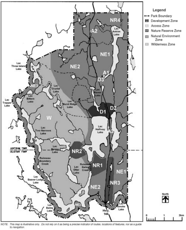
7.1 Development zones
"Development zones provide access, as appropriate, where large numbers of people are accommodated with services for day-use and camping."
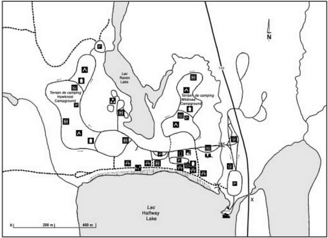
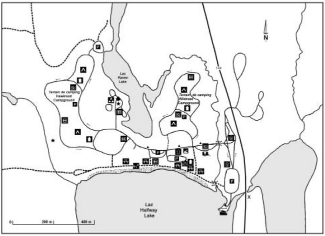
D1 Halfway Lake campgrounds and day-use zone (88 ha)
This zone provides the main access to the park and its facilities and services for a range of day- use and camping activities. The campground area consists of two campground loops (Hawknest & Wildrose), a group camping area that comprise two separate sites, parking area and trailhead to access backcountry hiking trails, and three comfort stations with showers and laundry facilities, two of which are wheelchair accessible. The day-use area consists of a comfort station, an amphitheater, park store, interpretive resource centre, park office and utilities as well as a beach and picnic area and playground equipment. A boat launch, fish cleaning station, trailer storage area and access to the western canoe route are also within this area. (Figure 4 & Section 10.1)
D2 Operations zone (23 ha)
This zone is located east of Highway 144 and north of Halfway Lake. The maintenance area, power distribution, water system, heli-pad, workshop and staff residences are located here.
D3 Antrim service zone (1 ha)
This development zone includes a park borrow pit and a sewage disposal site which have been in this area for several years. (Section 8.6.1 & 8.7.3)
7.2 Access zones
Access zones are established to provide a minimum of facilities to support access to the park’s natural environment. The access zones were selected in areas of minimal physical and cultural significance required for recreational use. In addition, the sites permit easy access from Highway 144. Development in access zones may include roads, parking, sanitary and support facilities (as specified in Provincial Parks Development Policies).
A1 Antrim Lake (2 ha)
The Antrim Lake access zone provides backcountry canoeing access to the NE1 Zone. The existing infrastructure includes a road and parking area. (Section 10.5)
There is no camping permitted in this access zone.
A2 Osprey Heights Trailhead (1 ha)
This zone provides access, parking and a privy at the Osprey Heights Trailhead. This trailhead provides access to a seven kilometre day-use hiking trail. (Section 10.2.1)
A3 Group camping
This is a proposed zone that may be developed to provide group camping. (Section 10.1.3)
7.3 Natural environment zones
"Natural environment zones include aesthetic landscapes in which there is a minimum of development permitted to support low-intensity recreational activities." Development will be limited but not restricted to backcountry campsites, roofed accommodations, portages, trails, signs, minimal interpretive structures, and ancillary facilities. (Section 10)
Two natural environment zones (NE1 & NE2) encompass approximately half of the park, centered on the Highway 144 corridor. Lands to the east of the Highway 144 corridor are intended to provide protection and management to support low-intensity recreation activities. A third natural environment zone (NE3) will encompass the park addition (P321, 383 ha) identified in Ontario’s Living Legacy Land Use Strategy (1999).
NE1 Antrim Lake/Halfway Lake (1,400 ha)
This zone contains rolling forested shield terrain, the existing Osprey Heights Hiking Trail (7 km), Antrim Lake and the eastern basin of Halfway Lake, a canoe route with four backcountry campsites and an overhead powerline corridor (1 km long and 15 m wide) from Onaping Lake. (Section 8.2.5 & 11.1)
NE2 Halfway and Raven Lakes Highlands (900 ha)
This zone includes Halfway and Raven Lakes and immediate shorelands. This zone offers canoeing and hiking as well as motor boating opportunities on Halfway Lake. The zone surrounds the Halfway Lake Campground and Day-Use Zone (D1) and consists of a canoe route through Halfway Lake and uplands connecting backcountry uses to the wilderness zone. Some of the backcountry hiking trails occur in this zone. (Section 10)
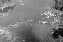
The weir on Halfway Lake occurs in this zone at the outlet to Bailey Lake. (Section 8.3.3)
NE3 Boundary waters (383 ha)
The Halfway Lake Addition (P321), as identified in Ontario’s Living Legacy Land Use Strategy (1999), is represented by this natural environment zone. (Section 8.1)
This zone contains much of the headwaters to the lake system on the western and southern side of the park. The moderately broken ground moraine landform is forested here with jack pine, white birch and poplar. Some scattered white pine also occur. This area contributes to the protection of landform, drainage, vegetation values and sensitive natural features. (Section 6, 8-10)
7.4 Wilderness zone
The wilderness zone defines the large, contiguous, undisturbed landscapes of the park’s backcountry. This zone serves to protect the ecological integrity of outstanding natural landscapes, as well as provide recreational opportunities and educational benefits for park visitors. Specifically, the wilderness zone provides opportunities for low-intensity recreation activities such as canoeing, hiking, viewing, photography and nature studies.
In recognition of the wilderness zones attributes and sensitivities, only passive, low-intensity activities such as hiking, interior camping, canoeing and heritage appreciation are designated as permitted uses. Development in the wilderness zone is limited to the absolute minimum required to facilitate interior hiking and canoeing such as trails, campsites, portages and necessary signs for route and campsite identification.
W Boreal Forest and Lake wilderness zone (2,200 ha)
This zone is centered on a representative landform vegetation complex that is the central natural heritage feature in the park. Here, ground moraine with rolling bedrock terrain is dominated by jack pine, white birch and poplar associations.
The wilderness zone contains the more remote portions of the park. This zone will protect significant natural, historical and recreational features that are suitable for wilderness experiences. Necessary management controls will be implemented to achieve protection, recreation and heritage appreciation objectives.
This zone will be managed to provide high quality wilderness experiences in the park. This zone includes Bailey Lake, Otter Lake, Beaver Lodge Lake, Moose Muck Lake, Two Narrows Lake, Trapper Lake, Bittern Lake and Three Island Lake. Canoeing potential will be assessed and additional campsites and portages may be permitted. The canoe route’s lakes represent small lake boreal environments. The lakes are shallow as are their connecting drainages. Low flows in these streams occur in most years. A portion of the thirty kilometre overnight hiking trail, Hawk Ridge Trail, is located in this zone. Campsites can be found along the trail within this zone.
The hiking trail potential of upland areas in the zone has only been partially developed. (Section 10)
7.5 Nature reserve zones
Nature reserve zones include significant earth or life science features that require management distinct from that in adjacent zones. Development within these zones will be restricted (e.g. day-use trails). The priority for nature reserve zones will be protection (Section 5.1) and research (Section 9.2).
The following descriptions highlight representative natural features of each zone:
NR1 Black Spruce/Larch Wetland (33 ha)
This zone consists of black spruce, larch and low shrubs, which dominate this low area between Halfway Lake and Bailey Lakes.
NR2 Black Spruce Wetland (45 ha)
This zone consists of low lying kettle depressions, which occur west of the south end of Halfway Lake. An organic mat has developed here supporting black spruce as the dominant tree species.
NR3 Boreal Creek Wetland (35 ha)
This zone consists of a series of graminoid and low shrub wetlands that are linked together along this stream system draining into Smoke Lake.
NR4 Antrim Boulder Field (2 ha)
This zone consists of a periglacial deposit, a feature that was created at the retreating edge of the glacier, consists of an extensive deposit of rounded granitic boulders. Some of the boulders are two metres in diameter. The feature is east of Antrim Lake on a minor drainage. Given the size of these boulders it has been suggested that a large volume of water, such as the melting edge of a glacier may have moved the boulders in an ancient river bed.
8.0 Resource management policies
Halfway Lake Provincial Park will be managed according to the Ontario Provincial Park Planning and Management Policies for natural environment class provincial parks, this Management Plan, and minimum operating standards. A Park Operating Plan is required for the infrastructure in the park (Section 9.0 & 11.1). This will reflect provincial operating standards and will be kept current to implement and guide the specific operational aspects of managing the park.
Although the policies herein are presented in separate categories, planning and management recognizes that the components are interrelated and that operations will ensure overall park objectives are achieved.
Ontario’s Living Legacy Land Use Strategy (1999) alters some resource management policies for Halfway Lake Provincial Park. The prevailing policies for the park addition (P321) are defined within this Management Plan, Ontario Provincial Park Planning and Management Policies and Ontario’s Living Legacy Land Use Strategy (1999).
8.1 Ontario’s Living Legacy - Halfway Lake addition (P321, NE3, 383 ha)
The following are some resource management policies for the park addition:
8.1.1 Sport fishing
Ontario’s Living Legacy Land Use Strategy (1999) has not altered provincial park policies for sport fishing. Within the park addition, sport fishing is permitted as per the Ontario Recreational Fishing Regulations Summary.
8.1.2 Commercial bait fishing
Existing commercial bait fish operations occurring within the park addition will be permitted to continue, subject to conditions identified in Provincial Park and Fisheries Management Plans. (Section 9.3.2)
No new operations will be permitted in the park addition, however active licences may be transferred where commercial bait fishing is an established permitted use.
8.1.3 Hunting
Hunting is permitted by Ontario Regulation 687/00, Schedule 74 under the Fish and Wildlife Conservation Act within the regulated Halfway Lake Addition (O.Reg 685/00, 383 ha, NE3). (Figure 3, 7.3 NE3)
8.1.4 Trapping
Authorized trapline operations occur within the regulated park addition (O.Reg 685/00, 383 ha). This activity will continue. The relocation of existing trails and cabins will be subject to ecological principles and management planning. (Figure 3, 7.3 NE3). (Section 9.3.2)
The transfer of authorized traplines may be permitted. If a commercial licence is revoked or surrendered, all portions of the registered trapline within the park will be rescinded from the trapline’s legal description.
New operations including trap line cabins and trails will not be permitted.
8.1.5 Mineral exploration
Within the park addition (O.Reg 685/00) mineral exploration may occur under controlled conditions
8.2 Vegetation management
Vegetation in the park will be managed in keeping with natural vegetation succession processes and recreation objectives. An ecological survey will be completed to map and describe vegetation patterns in the park. (Section 5.1, 7.0, 9.2 & 11.1)
8.2.1 Protection
A Vegetation Management Plan will be prepared for the entire park (Section 5.1, 8.2.3, 8.7.2, 10.1.1, 10.3.7 & 11.1). The plan will include campground and day-use areas to ensure the maintenance of a successional (regenerating) tree and shrub cover and a safe and aesthetic setting for visitors. Priorities will be given to rehabilitate the Halfway Lake beach day-use area. A detailed examination of the sensitive beach and shoreline plant communities will be undertaken. This will provide direction for the restoration of shoreline vegetation (Section 8.7.1 & 10.3.7). Educational and passive restraining methods to reduce erosion caused by foot traffic, will concentrate on diverting use around or away from areas that are susceptible to erosion. The Vegetation Management Plan will describe the role of fire and insect defoliation cycles in vegetation patterns for the park and area. (Section 8.2.3 & 8.2.4)
8.2.2 Vegetation control
Campsites will continue to be monitored for dying or unhealthy trees (hazard trees), and replacement planting will be implemented following the Vegetation Management Plan for the Halfway Lake Campground and Day-Use Zone (D1). Generally, trees will be removed from developed areas of the park if there is a threat to public safety and property or where it is necessary to meet the park’s recreation objective. Vegetation control will be permitted where necessary along public utilities and rights-of-way. (Section 8.2.1, 8.7.2, 10.1.1 & 11.1)
In the development zones, trees may be removed for development and management purposes. Where trees are removed for these purposes, they may be used for firewood.
8.2.3 Insects and disease
Insects and disease may be managed according to the completed Vegetation Management Plan where aesthetic, cultural, or natural values are threatened, except in nature reserve and wilderness zones where the natural process of vegetation change will be monitored. The Vegetation Management Plan will provide direction to address management needs for the nature reserve and wilderness zones. Where information is found to warrant management controls, problem areas will be narrowed so as to minimize effects on other components of the park environment. Guidelines established by the Ontario Ministry of Natural Resources and the Ontario Ministry of Environment will be implemented. Biological controls will be used in preference to chemicals, where feasible.
8.2.4 Forest fire management
All forest fires occurring within the boundaries of the park will be assessed and acted on in accordance with the prevailing Fire Area Strategies for the land base.
Protection from fire will be provided in all cases where life and property are threatened.
8.2.5 Powerline corridor
A single powerline enters the park from Onaping Lake to the east side of Halfway Lake, east of Highway 144. A strategy will be developed to address the management of vegetation removal, within the park, under the powerline. Hand tending will be the preferred method of cropping woody growth within the powerline corridor. (Section 7.3 NE1, & 11.1)
8.3 Water management
8.3.1 Water quality
Halfway Lake is the campground’s water source. The Ontario Ministry of Natural Resources will monitor water quality (drinking and beach) to ensure human health and safety.
8.3.2 Motorboats and recreational watercraft
Motorboat and recreational watercraft use on Halfway Lake may be monitored to determine water quality levels and potential long-term effects on the lake and fishery due to the operation of motorboats and recreational watercraft. (Section 9.3.2 & 11.1)
8.3.3 Halfway Lake weir
A weir maintains water levels on Halfway Lake. Further research (cost, feasibility of upgrading/removing/maintaining, alignment, environmental, etc..), and public consultation will determine the function and effects that this structure has on park values. The weir will be managed according to the findings of the above research, consultation and approved site plans. (Section 7.3 NE2, & 11.1)
8.4 Fisheries management
The park’s aquatic ecosystems include both warm and cold water. Fisheries and angling will be monitored in those water bodies containing viable fish populations. Halfway Lake’s most sought after fish species is lake trout, which is fished year round. Policies and regulations may be developed to restrict fishing pressures to maintain a natural reproducing lake trout population. At present it appears that this resource can continue to be fished following regulations that prevail for the area.
Other policies, as described in the Sudbury District Fisheries Management Plan (1990), which apply to lake trout populations will be studied with the view of establishing the current level of harvest and the "health" of the park population(s). (Section 2.3, 11.1 & 11.2)
8.4.1 Non-native fish introductions
Non-native fish species will not be introduced.
Bait fish
Provincial park policy for natural environment class parks states that the use or possession of bait fish is prohibited in waters within the park. (refer to Ontario Recreational Fishing Regulations Summary for definition of bait fish).
In order to comply with provincial park policy and reduce the risk of accidental introductions, regulations, under the appropriate legislation, to prohibit the use or possession of live bait will be established. (Section 11.1)
8.4.2 Sanctuaries
Prior to any changes in fisheries management or regulations further research and public consultation will be carried out to determine the status of angling and fish populations on lake trout in Halfway Lake and whether a sanctuary is required. Seasonal restrictions such as angling from the third Saturday in May to September 30th, with a sanctuary from December 1st to opening day in May will be explored. Angling for alternate species may not be permitted during the period covered by the sanctuary. (Section 11.1)
Regulations involving lake trout management will be discussed with the MNR District office and may be rolled into a Regional Lake Trout Management Strategy.
8.4.3 Commercial bait fishing
Commercial bait fishing, within the park area regulated prior to July 1999, will be permitted to continue, except in wilderness and nature reserve zones, where these activities will be phased out by January 1, 2010. (refer to Section 8.1.2 for OLL policy for the park addition) (Section 9.3.2)
No new operations will be permitted in the park, however active licences may be transferred where commercial bait fishing is an established permitted use.
8.4.4 Ice fishing
This activity primarily occurs on Halfway Lake. Access occurs via snowmobile from the Highway 144 corridor. The use of snowmobile access to Halfway Lake and ice fishing will be reviewed through future park and fisheries management planning. (Section 9.3.2 & 11.1)
8.5 Wildlife management
A Wildlife Management Plan will be prepared and implemented with the assistance of the Ontario Ministry of Natural Resources district biologists. The objective of the Wildlife Management Plan will be to provide wildlife viewing and heritage appreciation. The plan will address needs for research and special regulations that may be required for various species (e.g. moose, black bear, endangered species, etc). (Section 11.1)
Select controls of animal populations will be implemented under the strict supervision of the Park Superintendent, or directly by, the Ontario Ministry of Natural Resources. Such control will only be directed at populations requiring attention (e.g. animals compromising public safety).
8.5.1 Hunting
In accordance with Provincial Park policy and public input, hunting has not been permitted within Halfway Lake Provincial Park since Regulation. As such, hunting is not permitted within the regulated park boundary [O. Reg 250/80 & 821/80, Schedule 125; area (4,730 ha) regulated prior to July 1999]. (refer to Section 8.1.3 for OLL policy for the park addition)
8.5.2 Trapping
In accordance with Provincial Park policy and public input, trapping has not been permitted within Halfway Lake Provincial Park since Regulation. As such, trapping is not permitted within the regulated park boundary [O. Reg 250/80, Schedule 125; area (4,730 ha) regulated prior to July 1999]. (refer to Section 8.1.4 for OLL policy for the park addition)
New operations including trap line cabins and trails will not be permitted.
Status Indians exercising treaty rights are permitted to continue commercial fur harvesting, subject to applicable legislation and regulation.
8.5.3 Endangered species
The Bald Eagles, a provincially endangered species within Ontario and protected under Ontario’s Endangered Species Act, nest in the park. In order to protect the species and its habitat, managers will follow the MNR Bald Eagle Habitat Management Guidelines (1987) and may follow other relevant management guidelines. Ontario Parks and MNR District staff will work together to ensure the protection of this species through prescriptions for adjacent access and forest management planning. Ontario Parks, District MNR and adjacent forest management interests will work together to provide site and landscape level monitoring of this endangered species. (Section 11.1)
Research (e.g. inventories, assessments, etc.) of any vulnerable, threatened or endangered species found within the park may be considered. (Section 9.2)
8.6 Mineral exploration
Mineral exploration and mining is not permitted within Halfway Lake Provincial Park. (refer to Section 8.1.5 for OLL policy for the park addition)
8.6.1 Borrow pit
The extraction of aggregate will not be permitted except as permitted by regulation. Park aggregate needs required for maintenance and capital improvements will be brought in from an external source. There is a borrow pit to the west of Highway 144, south of the Antrim Lake access. An Aggregate Resources Rehabilitation Plan for the borrow pit in the Antrim Service Zone (D3) will be prepared to provide for ongoing rehabilitation needs. (Section 7.1 D3 & 11.1)
8.7 Land management
8.7.1 Day-use
The rehabilitation of the beach day-use area will be a priority. The sensitive beach and shoreline plant communities will be examined and addressed in the Vegetation Management Plan (Section 5.1, 8.2.1, 8.2.3, 8.7.2 , 10.1.1, 10.3.7 & 11.1). Methods such as educational and passive restraint will be implemented to reduce erosion. Foot traffic will be diverted around or away from areas that are susceptible to erosion.
8.7.2 Campground
To ensure that all campsites are maintained to standards, campsite rehabilitation will be implemented through tree planting, scarification and approaches to soil conservation to ensure natural regeneration. The Vegetation Management Plan will address sustained successional tree regeneration in the campgrounds and maintaining adequate buffers between individual campsites and between campsites and park roads. (Section 5.1, 8.2.1, 8.2.3, 10.1.1 & 11.1)
8.7.3 Sewage disposal
The disposal of park sewage in this area will be reviewed. The current facility is approved by Ministry of the Environment (MOE) and follows terms and conditions identified in the Provisional Certificate of Approval. A strategy will be developed to review the future disposal of sewage in the park. This may include an alternate site within the park or disposal of sewage through other means (e.g. hiring services to remove sewage from the park). (Section 7.1 D3 & 11.1)
8.8 Adjacent land management
8.8.1 Adjacent protected areas
Areas adjacent to Halfway Lake Provincial Park may have implications for park management. Detailed descriptions and policies related to these areas can be found in Ontario’s Living Legacy Land Use Strategy (1999). The following are the adjacent areas:
Spanish River Provincial Park (P192)
The Spanish River is in site district 4E-3 and is a provincially significant canoe route offering novice to intermediate river and backcountry travel on a challenging scenic waterway. This park is 35,386 hectares and is located to the west and south of Halfway Lake Provincial Park.
Onaping Lake Conservation Reserve (C322)
This conservation reserve is situated in site district 4E-3. Onaping Lake is a large waterbody that is the headwaters of the Onaping River. This lake is a popular recreation area for fishing and boating. This conservation reserve is approximately 17,353 hectares and is located to the northeast of Halfway Lake Provincial Park.
8.8.2 Adjacent enhanced management areas
Onaping/Friday/Scotia Lakes Enhanced Management Area (E190a)
This enhanced management area (EMA) is an expansive area of high remote tourism, recreational, and resource sector (foresty, mining) value. This area will be managed to protect high quality recreational and remote tourism values while providing for forest management activities.
This EMA encompasses an area of approximately 31,390 hectares and is adjacent to the east boundary of Halfway Lake Provincial Park.
8.8.3 Forest operations
Forest management interests, MNR, the Park Superintendent and other agencies will work together to ensure that adjacent land uses (e.g. forestry, recreational uses) do not affect the park environment (e.g. park canoe routes, water quality, aesthetic value and endangered species) and park visitor experiences now or in the future. (Section 2.2, Appendix I)
The adjacent Crown lands that are managed for forest operations have identified prescriptions in the Spanish Forest Management Plan that recognize the park as a value. Area of Concern (AOC) prescriptions will provide a measure of integrity for the boundary, as forests are harvested and prevailing natural processes cause changes along the newly opened forest edge. Further to this, forest access roads that are required for forest harvest and renewal purposes will be minimized with special measures outlined in the Spanish Forest Management Plan. These measures will restrict access, scarify and replant temporary access required to harvest in the vicinity of the park. As an additional measure the Spanish Forest Management Plan specifies a seasonal separation of forest operations with no operations permitted within the modified area during the operating season for Halfway Lake Provincial Park.
AOC prescriptions have been identified in the Spanish Forest Management Plan to ensure protection of the aesthetics of forest settings adjacent to the park and restrict road access to the park. Policies related to access are also required (e.g. no new roads to park boundary) to ensure that general Crown land recreation use and park uses do not conflict with each other.
AOC prescriptions
The Spanish Forest Management Plan identifies an Area of Concern (AOC) which involves an 1800 metre area measured outward from the canoe route section of the park boundary. This AOC will also involve a 200 metre area measured outward from the north and east boundary of the existing park (not including the OLL addition). No harvesting will be permitted within the larger AOC from Victoria Day to the end of the third weekend in September, (which is the current park operating season) after which normal operations may be carried out.
New roads are being built on Crown lands west of the park. Tertiary roads and landings for forest management operations are permitted within 400 metres of the normal high water mark and within the AOC, only where no reasonable alternative exists and with prior written MNR approval. This provision in the Spanish Forest Management Plan to limit forest access roads 400 metres from the park boundary may keep unplanned access from developing on the west side of the park.
8.8.4 Access
Unauthorized access at Bailey Lake will be addressed. The location will be managed to prevent this use from affecting the park environment and its operations. (Section 2.2 & 11.1)
Access along the Highway 144 corridor will be reviewed with the Ministry of Transportation to establish appropriate access controls.
9.0 Operations policies
A Park Operating Plan will be prepared to provide staff with the necessary operational information to carry out day-to-day park operations. The plan will also address budgeting, staffing, maintenance schedules, enforcement, and emergency services. The provisions of the plan will be consistent with the approved Ontario Provincial Park Operating Standards (1992) and will be reviewed annually and updated as required. (Section 8.0 & 11.1)
9.1 Natural heritage education
Natural heritage education will be managed in accordance with this Management Plan and Provincial Park Minimum Operating Standards. A Natural Heritage Education Plan will outline specific guidelines for education management with the intent to assist park visitors in achieving maximum enjoyment and benefit while visiting the park during the operating season. The park will operate a Seasonal Activity level of Natural Heritage Education programs. (Section 5.3)
9.1.1 Public Information
Information concerning park resources, management, facilities and programs, and nearby points of interest will be available at key points throughout the park such as the park office, gatehouse and interpretive resource centre. Relocation of the interpretive resource centre will provide the visitor with a better environment to view the "Life at the Edge of the Boreal Forest" theme. (Section 5.3 & 11.2)
9.1.2 Interpretation
A Natural Heritage Education Plan will be prepared, reviewed and updated as necessary, to define a variety of opportunities for visitors to gain an understanding and awareness of, and an appreciation for, natural and cultural heritage values, and the park’s policies and management objectives (Section 9.1 & 11.1). All the park themes and approaches to information, interpretation and recreation skills development will be detailed in the plan.
The interpretive component will seek to create an understanding of the natural attributes of Halfway Lake Provincial Park. The main interpretive theme is "Life at the Edge of the Boreal Forest" on the Pre-Cambrian Shield.
Self-use interpretive facilities (e.g. signs, displays, plaques, pamphlets, leaflets, and special publications), as well as programs and the Resource Centre deliver park information, resource interpretation and park management messages. Programs providing interpretive opportunities [e.g. natural and cultural heritage of the area, guided hikes, audio visual presentations, logging history, forest succession and species diversity (plant and animals) may be offered.
A partnership may be developed with the forest industry to provide interpretive opportunities and explore the history of logging in the area. This may be carried out through interpretive programs and displays within the park and tours of the surrounding area. The Superintendent may explore the opportunities to develop such a partnership. (Section 11.1)
9.1.3 Recreation
Park staff will work with interested groups and agencies to educate and develop the outdoor skills of park visitors. Programs such as canoeing, backcountry travel and camping, and angling may be provided. The park’s trails and canoe routes will contribute to the heritage appreciation objective and provide a venue for natural heritage programming.
9.2 Research
Scientific research, by qualified individuals, that contributes to the knowledge of natural and cultural history and to environmental and recreational management, will be encouraged in the park. Ontario Parks will encourage institutions to undertake research projects. All research programs will require the approval of Ontario Parks and will be subject to provincial park policy and other applicable Legislation. Ontario Parks may approve the research of any natural or cultural specimens by qualified researchers. All such materials removed remain the property of the Ontario Ministry of Natural Resources.
Approved research activities and facilities will be compatible with the park’s protection objective. Any site that is affected will be rehabilitated as closely as possible to its original state.
A life science gap analysis report for the ecological Site District 4E-3 has identified representation potential for vegetation associations in the park. Ecological surveys will be required to describe life science values and to refine zoning (Section 5.1, 7.0, 8.2 & 11.1) and management prescriptions.
9.3 Recreation management
Recreation management in Halfway Lake Provincial Park will include day-use activities and facilities, campground camping and backcountry camping.
Day-use facility based activities will be based on interaction with the natural environment and appreciation for the park’s natural and cultural heritage values.
Recreation management in the park will be directed toward high-intensity uses associated with campground camping in the development zone, low-intensity backcountry camping and day- use activities such as hiking, snowshoeing, canoeing, swimming and angling within natural environment and wilderness zones. Backcountry users will be required to pack out non-burnable garbage, and management activities will be directed at maintaining minimum standards for the clean-up and general maintenance of portages and trails.
9.3.1 Cycling
New activities proposed in this Management Plan include a bicycle path in the development zone (D1), a bike trail in the Raven Lake area (NE2/D1) and a mountain bike trail.
A trail plan will be developed and approved for cycling activities within the park. (Section 10.2.2, 10.2.3, 10.3.1 & 11.1)
Bicycle path (D1)
A Camper Survey completed in 1992 indicated that at least 39% of visitors enjoy cycling in Halfway Lake Provincial Park. Since then the number of cyclists has increased.
This activity is occurring on main park roads which raises safety concerns. A bicycle path will provide a safe alternative to cycling on park roads.
Prior to any development further research (cost, feasibility) will determine the potential for future development of a bike path. (Section 10.3.1, 10.3.2, 11.1 & 11.2)
Bike trail - Raven Lake area (D1/NE2)
Prior to any development, further research (cost, feasibility) will determine the potential for future development of a bike trail and supporting infrastructure in the Raven Lake area. (Section 10.2.3 & 11.1)
Mountain biking
The demand for mountain biking infrastructure within the park will be assessed. Prior to any development, further research (cost, feasibility, alignment) and public consultation (i.e. user survey) will determine the role of mountain biking in the park. Site planning will determine suitable trail locations and an access zone in the park that will have minimal impact on the parks' environment. (Section 10.2.2, 11.1 & 11.2)
9.3.2 Motorized travel
Motorboats and motorized recreational watercraft
The park addition (P321) identified in Ontario’s Living Legacy Land Use Strategy provides camping opportunities associated with non- motorized backcountry use. (Figure 3, NE3 zone)
Regulations under appropriate legislation may be established to manage for non-motorized uses on lakes within Halfway Lake Provincial Park (except on Halfway Lake). (Section 11.1)
Motorboat and recreational watercraft use on Halfway Lake will be monitored. Should water quality levels and potential long-term effects on the lake and fishery be evident as a result of motorized uses, regulations may be established. Public consultation will take place prior to establishing such regulations. (Section 8.3.2 & 11.1)
As per the Provincial Parks Act, "no person shall launch, operate or possess a boat, water ski, sailboard, surfboard, watersled or any like thing in any water in a Provincial Park that is designated as a swimming area or upon any part of a beach adjacent there to."
Motorized use on park lakes (other than those designated for motorized use) will be restricted to MNR personnel for the purposes of maintenance, research and emergency situations.
Commercial access
Access to commercial traplines west of the park, in NE3, may continue. Access to commercial bait fishing operations may continue. To ensure park values are protected an agreement to access these traplines will be developed between operators and MNR Ontario Parks. (Section 8.1.2, 8.1.4, 8.4.3 & 11.1)
Snowmobiles
There are no designated trails or road allowances within the park that permit the use of snowmobiles. However, access by snowmobile occurs from Highway 144 to Halfway Lake to access the fishery. The use of snowmobiles will be permitted on Halfway Lake and the continuance of this activity will be reviewed through park and fisheries management planning. (Section 8.4.4)
All terrain vehicles
The use of ATVs within the park is not permitted.
Aircraft
As per the Provincial Parks Act, aircraft shall not land in Halfway Lake Provincial Park. Aircraft use within the park will be restricted for the purposes of maintenance, research and emergency situations.
The Ministry of Health and Long-Term Care heli-pad is located in the development zone (D2) east of Highway 144 and south of Halfway Lake.
9.4 Marketing
Halfway Lake Provincial Park will continue to be marketed as a distinctive natural area contributing to heritage protection and providing diverse recreational and tourism opportunities. The park will be marketed through its natural heritage education program and other initiatives as identified in the Park Marketing Plan (1980).
The Marketing Plan will be reviewed and updated as necessary. (Section 11.1)
Promotion of the park will endeavor to increase visitation through the following means:
- increase the length of stay;
- attract day users staying at commercial establishments in the Sudbury area;
- attract campers and day users during low use periods, mid-week and shoulder seasons;
- promote local tourist services and attractions; and,
- generally promote interaction between the park and the commercial sector.
Promotion of the park will be aimed at designated user groups through such means as brochure distribution, radio announcements, newspaper articles, television coverage, partnerships, posters and special events.
Ontario Parks' corporate marketing strategy is to enhance the profile of lesser known parks with Ontario residents and visitors to the Province.
9.5 Tourism services
The tourism thrust of the park will be to sustain use in a natural and scenic setting. The "Life at the Edge of the Boreal Forest" theme will be the main component to emphasize.
The existing interpretive resource centre will be relocated to a new "Resource Centre" to provide interpretive displays that fosters appreciation for Northern Ontario’s natural and cultural heritage. This new Resource Centre will include the existing interpretive resource centre and will be located in the development zone (Section 5.3, 10.4.1 & 11.2).
A partnership may be developed with the forest industry to provide tourism opportunities to park visitors. Exploring historic and current logging operations in the area may be carried out through tours of the area surrounding the park. The Superintendent may explore opportunities to develop such a partnership. (Section 11.1)
10.0 Development policies
Development will proceed in accordance with the policies of this approved Management Plan, Planning and Management Policies, Provincial Park Development Standards, and approved site and development plans. In all instances, approved, detailed site plans will precede all development (Figure 4, 5, 6 & 7). The requirements of the Environmental Bill of Rights, the Environmental Assessment Act and other pertinent acts will be adhered to.
Proposed development (Figure 5 & 7, Section 11.0) will be in accordance with this Management Plan, through work program planning and/or special funding initiatives.
10.1 Campground facilities
Halfway Lake Provincial Park will continue to offer 215 campsites and support facilities. There are 85 campsites in Wildrose Campground and 130 in Hawknest Campground. Halfway Lake Provincial Park also provides seasonal leased sites in both campgrounds.
Prior to any development, further analysis (e.g. cost, feasibility) will determine the potential for future expansion of the campground. Should the analysis identify a need for campground expansion, site plans will be developed and approved to determine suitable areas for expansion and support facilities. (Section 7.1- D1, 11.1 & 11.2)
Deteriorating privies will be upgraded or replaced in both campgrounds. (Section 11.1)
10.1.1 Campsite rehabilitation
Campsite rehabilitation, through tree planting, scarification and topsoil to natural regeneration, will be implemented to ensure that all campsites are maintained at standards recommended by park development guidelines. The Vegetation Management Plan will address sustained successional tree regeneration in the campgrounds and maintaining adequate buffers between individual campsites and between campsites and park roads. (Section 7.1 - D1, 8.2.1, 8.2.2, 8.7.2 & 11.1)
10.1.2 Comfort station
Site plans will be prepared and approved to upgrade the existing comfort station in the northern loop of Hawknest Campground to provide wheelchair access. (Section 7.1 D1, 11.1 & 11.2)
10.1.3 Group camping
The existing group camping area (D1) has good potential for roofed accommodations and will be considered as a prime area for this type of development. It could also be considered for campground expansion. (Section 11.1 & 11.2) A new area for group camping may be developed. Site analysis and planning will examine potential locations for group camping within the park (Section 7.2, A3). A proposed location is located on the east shore of Halfway Lake. Development will be limited to the absolute minimum area required to facilitate group camping. This will include infrastructure such as an access road, parking area, camping area and an independent water source and privies. (Section 7.2 - A3, 10.5, 11.1 & 11.2)
10.1.4 Roofed accommodations
Presently, the park does not reach its full potential in attracting some segments of the vacationing public in shoulder seasons. Further research (e.g. cost, feasibility) will be completed to determine the potential for future development of roofed accommodations to address these needs. Site plans using standard structures will be prepared and funding requested through capital programs for construction of roofed accommodations. Site plans will be developed and approved prior to any development or construction of roofed accommodations with water and sanitation services. (Section 5.2 & 11.1)
The facilities and services associated with roofed accommodations are permitted within selected zones of the park. These are outlined in a draft planning and management policy (1998). This policy will provide guidelines to the types of structures permitted within park zones until a policy is approved. The development zone(s) will be the first location considered for roofed accommodations.
Figure 4 Present campground development
Note: This map is illustrative only. Do not rely on it as being a precise indicator of routes, locations of features, nor as a guide to navigation.
Figure 5 Proposed campground development
Note: This map is illustrative only. Do not rely on it as being a precise indicator of routes, locations of features, nor as a guide to navigation.
Figure 6 Present interior development
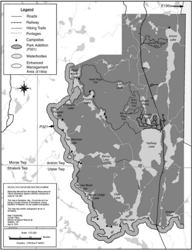
Figure 7 Proposed interior development

10.2 Backcountry facilities
The existing hiking trails, canoe routes, portages and campsites in the natural environment and wilderness zones will be upgraded and maintained. (Figure 3, Section 7.3, 7.4 & 11.1)
Minimal development (e.g. campsites) may occur within the park addition (NE3). (Figure 3, Section 7.3)
10.2.1 Hiking trails
The existing thirty kilometre overnight trail (Hawk Ridge Trail) will be maintained to operating standards. Campsites will be upgraded to include interior privies. A proposed extension of the Hawk Ridge Hiking Trail, in the wilderness zone, will be reviewed and linked to the existing system. Research (e.g. ecological survey), site analysis and approved site plans will be completed prior to any development. This extension will provide a choice for visitors to hike a longer, more demanding trail. Campsites and privies may be developed, as per approved site plans, along this extension. (Section 11.1 & 11.2)
The Osprey Heights Trailhead (A2) includes a privy, access to a seven kilometre day-use hiking trail, a parking area and trail information for park visitors. The hiking trail and trailhead will be upgraded and maintained. (Section 7.2 & 11.1)
10.2.2 Mountain bike trails
If further research (e.g. cost, feasibility) and public consultation (i.e. user survey) determine that mountain biking serves a viable role to park tourism and meets the parks' goal and objectives, site plans will be developed and approved to ensure the protection of park values prior to any development. Potential locations will be determined through site planning and the infrastructure would include a mountain bike trail and trail markers. An access zone would be developed and provide a trailhead, which would include an access road, parking area, interpretive displays and privies. This area will be addressed in the trail plan. (Section 9.3.1, 10.5, 11.1 & 11.2)
10.2.3 Bike trail - Raven Lake area
If further research (e.g. cost, feasibility) determines that this activity serves a viable role to park tourism and meets the parks' goal and objectives, site plans will be developed and approved to ensure the protection of park values prior to any development. The potential location for this activity would be north of the campgrounds in the Halfway and Raven Lakes Highlands Zone (NE2), site planning will determine the location. The trailhead location for the hiking trails will also be the trailhead location for this activity. The infrastructure would include a bike trail and trail markers. Trailhead infrastructure in the Halfway Lake Campground and Day-Use Zone (D1) provides a parking area and interpretive displays. This area will be address in the trail plan. (Figure 7, Section 9.3.1, 11.1 & 11.2)
10.3 Day-use facilities
Halfway Lake Provincial Park has an excellent and popular day-use picnic area with potential for increased use, particularly with residents and local tourists (Sudbury and Region). In recognition of this, efforts will be directed to improve and expand day-use facilities.
10.3.1 Bicycle path
If further research (cost, feasibility) determines that a bicycle path serves a viable role to park tourism and meets the parks' goal and objectives site plans will be developed and approved to ensure the protection of park values prior to any development. This path will provide safe cycling opportunities and a suitable area to construct a bicycle path, within the development zone (D1), will be selected and site plans developed and approved. (Section 9.3.1, 11.1 & 11.2)
10.3.2 Day-use/picnic area
The main day-use area will continue to be an important attraction at Halfway Lake Provincial Park. To enhance day-use, site plans will be developed and approved to construct picnic shelters, wheelchair access to the day-use area and a bicycle path (Section 9.3.1, 10.3.1, 11.1 & 11.2). Site plans will be developed and approved to upgrade the comfort station to provide wheelchair access. The existing park store will be expanded to offer a wider range of services to park visitors who will contribute to additional revenues for the park (Section 10.3.3 & 11.2). To accommodate day users, the parking area will also be expanded. (Section 11.2)
10.3.3 Park store expansion
As per approved site plans, the park store will be expanded to provide more space to accommodate the growing services for the park visitor (e.g. park merchandise, bike rentals). The park store may be connected to the new Resource Centre that will contain the existing interpretive resource centre and natural heritage education staff offices which are currently located in the park office. (Section 10.4.1 & 11.2)
10.3.4 Playground
The existing playground area will be upgraded to meet safety standards and new structures may be added to provide a variety of activities for visitors. (Section 11.1)
10.3.5 Firewood facility
A new firewood sale facility may be constructed to provide the visitor with access to firewood. This facility may be added to the park store. (Section 10.3.3 &11.1)
10.3.6 Boat launch
The existing boat launch facility requires upgrading as trailers and vehicles are becoming stuck on the lake bottom. The boat launching facilities will be upgraded and maintained to operating standards. This facility is important to the park visitors who engage in water related activities (e.g. angling, water skiing). The improvement of this facility will enhance the park effort to increase day-use visitation. (Section 7.1 D1 & 11.1)
10.3.7 Shoreline erosion
The Vegetation Management Plan will include direction to rehabilitate the shoreline in the day- use beach area, which has degraded as a result of recreational use (Section 8.2.1, 8.7.1 & 11.1).
10.4 Natural heritage education facilities
10.4.1 Resource centre
The existing amphitheater, located in the day-use area, is separate from the interpretive resource centre, which is located at the park office. This new Resource Centre will be located in the development zone providing visitors with a variety of services (e.g. natural heritage education programs, literature…) (Section 5.3 & 9.5). However, to provide services to visitors, a suitable area to construct a Resource Centre will be identified through site planning. A new Resource Centre will also provide more space in the park office and a new interpretive facility, which can accommodate more visitors' on a daily basis. The existing interpretive resource centre and natural heritage education staff offices will be relocated to the new Resource Centre. (Section 5.3, 9.1.1, 9.5 & 11.2)
10.4.2 Historic log chute
There are remnants of a wooden log chute between Halfway and Bailey Lakes. This feature is typical of structures that were built throughout the boreal forest to enable the movement of logs down otherwise shallow streams between lakes. This historic feature can be accessed by canoe. Information may also be available on maps and route guides and at the new Resource Centre and park office.
A partnership agreement with the forest industry may be developed to restore the log chute and/or place an interpretive sign at the remnants of the log chute between Halfway and Bailey Creek. (Section 11.1)
10.5 Roads and access
All existing roads (gravel surface and asphalt pavement), which service the campgrounds, day- use area, group camping areas, boat launch sites, and maintained/operational facilities will be maintained to standards (road standards). The parks deteriorating shoulders on asphalt roads will receive additional granular material and regrading. Road improvements (e.g. tar & chip) will be undertaken in both campgrounds. (Section 11.1)
The park addition (NE3) will be managed to retain its existing roadless undeveloped character. (Section 9.3.2)
The road and parking area in the Antrim Lake Zone (A1) will be upgraded to provide additional parking and an area to launch canoes will be developed as per approved site plans. (Section 7.2 A1 & 11.1)
Access roads may be developed for the purpose of accessing the proposed mountain bike trailhead and group camping area. (Section 10.1.3, 10.2.2 & 11.1)
There will be no new roads built to provide new entry points to the park (e.g. west boundary).
10.6 Other improvements
There is a need to undertake the following projects:
- Survey and mark the park boundary for definition and recreation management (e.g. unplanned roads). (Section 11.2)
- Upgrade the parks inadequate communications system (radio phone party line). (Section 11.1)
- Upgrade park office (e.g. relocate interpretive resources centre, NHE staff offices). (Section 11.1)
11.0 Implementation strategy
Implementation of this Management Plan will involve updating the Park Operating Plan on an ongoing basis, undertaking resource management plans and carrying out visitor services planning. Development of approved facilities will be based on site planning, work program planning and funding proposals through the Ontario Parks Zone Office. Ecological surveys will also expand the park resource information base. These surveys will be necessary to refine zoning (Section 7.0, Figure 3) and management prescriptions.
The following is a summary of proposed projects and improvement phases that have been identified within the Background Information Report and addressed by this Management Plan:
11.1 Operational and minor capital projects
Completion of this phase will provide basic guidelines for future development and operations. Further information for each project is provided in the Section(s) noted after each point. The following are not listed in order of priority.
Phase 1
Resource management
Manage the weir according to findings of the above research and consultation and develop and approved site plans accordingly. (Section 7.3 NE2 & 8.3.3)
Conduct further research and public consultation prior to any changes in fisheries management/regulations (e.g. sanctuaries, snowmobiles). (Section 8.4.2 & 8.4.4)
If water quality levels and potential long-term effects are evident, regulations may be established. Public consultation will take place prior to the establishment of regulations. (Section 8.3.2 & 9.3.2)
- Complete ecological survey for the entire park (e.g. define zoning). (Section 5.1, 7.0, 8.2 & 9.2)
- Prepare a park Vegetation Management Plan and include direction for shoreline restoration and management needs for nature reserve and wilderness zones. (Section 5.1, 8.2.1, 8.2.2, 8.2.3, 8.7.1, 8.7.2,10.1.1 & 10.3.7)
- Develop a strategy to address vegetation management of the powerline corridor (Section 7.3 NE1 & 8.2.5)
- Prepare an Aggregate Resources Rehabilitation Plan to rehabilitate the borrow pit. (Section 7.1 D3 & 8.6.1)
- Conduct further research (cost, feasibility of upgrading/removing/maintaining, alignment, environment, etc.) and public consultation to determine the function and effects of the weir. (Section 7.3 NE2 & 8.3.3)
- Prepare Wildlife Management Plan. (Section 8.5)
- Monitor and complete studies to determine the current level of harvest and assess the health of lake trout populations and review policies and regulations along with the Sudbury District Fisheries Management Plan (1990). (Section 2.3 & 8.4)
- Monitor and protect endangered species. (Section 8.5.3)
- Monitor motorboat and recreational watercraft to determine water quality levels and potential long-term effects on the lake and fishery of Halfway Lake. (Section 8.3.2 & 9.3.2)
- Address unauthorized access at Bailey Lake and review access from the Highway 144 corridor with the Ministry of Transportation. (Section 2.2 & 8.8.4)
Day-Use
If further research (cost, feasibility) determines that this activity serves as a viable role to park tourism & meets the parks goal and objectives, site plans will be developed and approved prior to any development. (Section 10.3.1)
- Upgrade and maintain boat launching facility. (Section 7.1 D1 & 10.3.6)
- Prepare and approve site plans and construct wheelchair access to day-use area. (Section 10.3.2)
- Prepare and approve site plans to upgrade the day-use comfort station to provide wheelchair access. (Section 10.3.2)
- Prepare and approve site plans and construct picnic shelters. (Section 10.3.2)
- Maintain playground area and upgrade with new structures. (Section 10.3.4)
- Conduct further research (cost, feasibility) to determine potential development of a bicycle path. (Section 7.1 D1, 9.3.1 & 10.3.1)
Campground
If further research (e.g. cost, feasibility) determines that campground expansion is required, site plans will be developed and approved. (Section 10.1)
If further research (e.g. cost, feasibility) determines that roofed accommodations serve a viable role and meets park goal and objectives, the types of structures and the quantities of roofed accommodations will be examined in the park. (Section 7.3 & 10.1.4)
Site plans will be developed and approved based on feasibility, type of roofed accommodations/locations. (Section 7.3, 10.2.1, 10.1.4 & 10.5)
- Prepare and approve site plans to upgrade the comfort station (Hawknest) to provide wheelchair access. (Section 7.1 D1 & 10.1.2)
- Upgrade or replace privies in the campgrounds. (Section 10.1)
- Rehabilitate campsites through scarification, topsoil, and tree planting. (Section 8.2.1, 8.7.2 & 10.1.1)
- Maintain park roads. Upgrade and regrade shoulders of asphalt roads. (Section 10.5)
- Evaluate potential group camping in the park. (Section 10.1.3 & 10.5)
- Conduct further research (e.g. cost, feasibility) to determine potential expansion of the campground. (Section 10.1 & 10.1.3)
- Conduct further research (e.g. cost, feasibility) to determine potential development of roofed accommodations. (Section 10.1.4)
Backcountry facilities
If further research (e.g. cost, feasibility) determines that this activity serves as a viable role and meets park goal and objectives, site plans will be developed and approved to ensure protection of park values prior to any development. (Section 10.2.3)
If further research (e.g. cost, feasibility) and public consultation (i.e. user survey) determines that mountain biking serves as a viable role, site plans will be developed and approved. (Section 10.2.2)
- Conduct further research (e.g. cost, feasibility) to determine potential development of the Raven Lake bike trail. (Section 9.3.1)
- Conduct further research (e.g. cost, feasibility) and public consultation (i.e. user survey) to determine the role of mountain biking in the park. (Section 9.3.1)
- Conduct further research (e.g. ecological survey), site analysis and planning prior to development of the Hawk Ridge Trail extension. (Section 10.2.1)
- Upgrade road and parking in Antrim Lake Zone (A1) and develop an area to launch canoes as per approved site plans. (Section 7.2 A1 & 10.5)
- Upgrade and maintain hiking trails and trailhead at Osprey Heights Trailhead (A2). (Section 7.2 & 10.2.1)
- Upgrade and maintain existing hiking trails and support facilities in wilderness and natural environment zones (e.g. campsites, portages, signs & privies) as per approved site plans. (Section 7.3, 7.4, 10.2 & 10.2.1)
Administration/operations
- Develop a strategy to review the future disposal of sewage in the park. (Section 7.1 D3 & 8.7.3)
- Prepare, review and update (as necessary) Park Operating Plan. (Section 8.0 & 9.0)
- Prepare, review and update (as necessary) a Natural Heritage Education Plan. (Section 9.1 & 9.1.2)
- Review and update the Park Marketing Plan. (Section 9.4)
- Establish regulations for non-mechanized uses on lakes within the park, with the exception of Halfway Lake. (Section 9.3.2)
- Construct a new fire wood sale facility. (Section 10.3.5)
- Upgrade communications system (radio phone party line). (Section 10.6)
- Upgrade park office. (Section 10.6)
- Establish a partnership with the forest industry to provide tourism and interpretive opportunities. (Section 9.1.2 & 9.5)
- Develop a partnership with the forest industry to determine an approach to restore and/or replace an interpretive display at the location. (Section 7.3 NE2 & 10.4.2)
- Establish an agreement between MNR Ontario Parks and commercial trappers that enables trappers to access traplines. (Section 8.1.4 & 9.3.2)
- Establish an agreement between MNR Ontario Parks and commercial bait fishing operators that enables access to their areas. (Section 8.1.2, 8.4.3 & 9.3.2)
- Establish regulations to prohibit use or possession of live bait. (Section 8.4.1)
11.2 Major capital projects
Completion of this phase will provide basic facilities to encourage a more stable and positive financial contribution to the parks system. Further information for each project is provided in the Section(s) noted after each point. The following is not listed in order of priority.
Phase 2
Day-use area
- Expand park store as per approved site plans. (Section 10.3.2 & 10.3.3)
- Expand day-use parking as per approved site plans. (Section 10.3.2)
- Construct a bicycle path as per Phase 1 and approved site plans. (Section 9.3.1, 10.3.1 & 10.3.2)
Campground areas
- As per approved site plans, upgrade the comfort station in Hawknest Campground to provide wheelchair access. (Section 10.1.2)
- Expand the campground as per Phase 1 and approved site plans. (Section 10.1 & 10.1.3)
- Develop alternate group camping area and support facilities as per site analysis, Phase 1 and approved site plans. (Section 10.1.3 & 10.5)
- Construct roofed accommodations as per Phase 1 and approved site plans. (Section 10.2.1, 10.1.4 & 10.5)
Backcountry facilities
- Expand Hawk Ridge Trail and develop campsites and privies along this extension. (Section 10.2.1)
- Construct a bike trail in the Raven Lake area, as per Phase 1 and approved site plans. (Section 9.3.1 & 10.2.3)
- Construct a mountain bike trail as per Phase 1 and approved site plans. (Section 9.3.1, 10.2.2 & 10.5)
Resource management
- Survey and mark the park boundary. (Section 10.6)
- Implement findings from the lake trout population assessment and apply necessary management tools/regulations to protect the resource. (Phase 1 & Section 8.4)
Administration/operations
- Construct a Resource Centre and relocate the interpretive resource centre as per approved site plans. (Section 9.1.1, 9.5 & 10.4.1)
- Develop a trail plan for cycling activities (e.g. bike path, mountain biking, etc. ). (Section 9.3.1, 10.2.2, 10.2.3 & 10.3.1)
12.0 Social and economic impact analysis
Halfway Lake is an important part of the region’s tourism infrastructure.
The projects and activities identified provide a wide range of social and economic benefits both within the park and in the surrounding area.
12.1 Benefits of provincial parks and protected areas
Provincial parks and protected areas, such as conservation reserves, provide a wide range of benefits. Some of the benefits can be measured in economic terms other benefits cannot. Traditionally, parks and protected areas have reported on the economic impacts associated with park and visitor expenditures.
12.2 Economic impacts (Benefits from expenditures)
Economic impact is a way to track and demonstrate the flow of park and visitor expenditures in the economy. The following are economic impacts associated with park expenditures and the estimated visitor spending at Halfway Lake for fiscal 1998/99.
Park and visitor spending 1998/99
The estimated total initial expenditure at Halfway Lake during fiscal 1998/99 was $2,477,979. A total of $279,780 was spent on park operations. Capital expenditures amounted to $108,200. Camper and day visitor expenditures on food and beverages, fuel and transportation, attractions and entertainment and miscellaneous totaled $2,089,999.
Ontario Parks reports on the following indicators of economic impact (Appendix II):
- Value Added
- Provincial Gross Sales (or Provincial Gross Output)
- Wages & Salaries
- Provincial Person Years of Employment
As noted previously, economic impacts are based on expenditures. The expenditures made by the park on operations and capital as well as average visitor trip expenditures (camper and day visitor) compose the initial expenditure. Visitor expenditure information is taken from the 1998 Park User Survey. The visitor expenditures are taken from the 1998 Day Visitor and Camper Surveys for Halfway Lake. Park operating and capital expenditures are taken from the unit cost analysis sheets. The above noted information is entered into an input-output model licensed to MNR for economic analysis.
Based on an initial expenditure of $2,477,979 the following impacts were sustained at Halfway Lake (the figures are for the total economic effects (direct + indirect + induced effects):
- Value Added (a conservative and more accepted measure of impact) - $3,210,392.
- Provincial Gross Sales (or Provincial Gross Output)- $6,226,377 (the problem with this figure is that it double counts)
- Wages & Salaries - $1,890,020
- Provincial Person Years of Employment – 66.5
There are other benefits which provincial parks and protected areas provide to local communities, the province and society in general. A number of important benefits are listed below. These benefits demonstrate how parks and protected areas support our quality of life:
- protection and contribution to ecological functions (water & soil production),
- protection of resource integrity (some of the last green spaces left in the province),
- health effects from use of parks (mental, physical, spiritual benefits),
- worker productivity (healthy and happy workers tend to be more productive - a visit to a provincial park can contribute),
- educational benefits (young and old learning about our environment),
- scientific benefits (research in provincial parks),
- international responsibilities to protect natural settings, features and wildlife,
- business location decisions (quality of life/business) and community cohesion.
Provincial parks and protected areas help to make communities attractive for businesses as well as for tourists and retirees. The retirement community brings in pension income, which is often indexed to inflation and is recession proof. Communities with attractive waterfronts, low crime, recreational activities and healthy environments are sought out by tourists, the retirement community and businesses. The park budget (operating and capital) represents a grant or transfer payment from the provincial government to communities. Not all communities have this transfer. The community may also receive grants in lieu of taxes.
One of the most often sought after and tangible measures of the social and economic contribution of a protected area is the number of jobs supported. The combined economic activity at Halfway Lake supports 66.5 person years of employment in the province each year. Park related spending provides the area with employment opportunities and contributes to a stable local economy and community.
13.0 Plan review
This Management Plan will be reviewed on an ongoing basis throughout its twenty year life span, a mandatory review will take place in ten years or as necessary. The review will be implemented in the following manner.
- Review initial management planning process.
- Update background information and data on park resources and use.
- Review plan implementation and provincial policies.
- Identify new issues or concerns.
- Prepare issues and solutions document for public review.
- Review and receive approval for plan amendments.
14.0 Public consultation
Management plans are the result of a continuing consultation process that has considered the needs, desires, and opinions of a variety of interests. The Ontario Ministry of Natural Resources' approach to the management of Halfway Lake Provincial Park presently and in the future attempts to achieve a balance of economic, social and environmental interests.
Public involvement in the development of the Halfway Lake Provincial Park Management Plan first began during the summer of 1997, displays were set up in the park and there were opportunities for the public to comment on the Background Information (in July-August, 1997). Background information on management planning for Halfway Lake Provincial Park was compiled in 1996, and the Preliminary Management Plan was released for public review and comment in August 1998. Comments regarding the Preliminary Management Plan were submitted to the Park Superintendent. All comments received were taken into consideration upon the completion of this Management Plan. In applying this Management Plan, the Ontario Ministry of Natural Resources is committed to continuing this consultation with government agencies, other ministries, interest groups, and the public. It is important that the current level of communication that has been established by this consultation process be maintained. This Management Plan has been developed following guidelines as set out in the Ontario Provincial Parks Planning and Management Policies (1992), Ontario’s Living Legacy Land Use Strategy (1999) and the Sudbury District Land Use Guidelines (1983).
The planning process followed several methods of consultation, which enabled the public to comment on the management planning for Halfway Lake Provincial Park.
These methods consisted of:
Mailing lists
- Mail out of Preliminary Management Plan to those on the mandatory mailing list (PM 11.02.02) and to individuals who requested to be put on the mailing list.
- Mailing list of local residents and businesses.
- A public notice indicating plan approval and where copies may be obtained was mailed to mailing list members.
Newspaper notices
- Newspaper notices were posted in the following newspapers: Sudbury Star, Northern Life and Le Voyageur.
Public meetings
- Public meetings on request or as the Superintendent deemed necessary, were held over the duration of the project.
- January and February 1999 Ontario Parks staff and the Park Superintendent met with District MNR staff and Domtar (EB Eddy) to discuss the potential expansion of the park boundary. (this expansion was captured through OLL)
Environmental Bill of Rights Registry
- EBR Notices were posted for 45 days (during the Invite to Participate, Preliminary Plan and Approved Plan stages) to provide the public with an opportunity to comment.
Comment sheet
- The Preliminary Management Plan included a comment sheet for public input and submissions were directed to the Park Superintendent.
Ontario’s Living Legacy
- Opportunities for public comment were provided throughout this land use planning process.
- Opportunities for public comment on the Halfway Lake Provincial Park Addition (P321) Fact Sheet was provided November 15 to December 15, 1999.
- Halfway Lake Addition (P321) was regulated in December 2000.
During the management planning process public comments were received. Many verbal comments were received as well as seventeen written responses. Five comments were received through Ontario’s Living Legacy land use planning process.
All comments received were considered during the completion of this Management Plan.
15.0 References
Crins, B. 1996. Gap Analysis of Site District 4E-3. OMNR. Huntsville.
Econometric Research Limited, 1995.
Fish & Wildlife Conservation Act, 1997.
Frey, E.D. 1991. Earth Science Systems Plan, Prefield Stage for the Northeastern Region, for OMNR, Sudbury.
Harris, 1984. The Fragmented Forest.
Noble, T.N. 1983. Life Science Report for Site Region 4E. OMNR. Sudbury.
Penak, B. February 1983, revised June 1983. Management Guidelines and Recommendations for Osprey in Ontario. Ontario Ministry of Natural Resources.
Ontario Ministry of Natural Resources, March, 2000. Northwest Region Interim Direction for: 1) clarification of what constitutes "exception" to recommendations of the Bald Eagle, Osprey & Heron Guidelines, 2) describing the requirements of a monitoring plan for any declared exceptions.
Ontario Ministry of Natural Resources, 2000. Ontario Recreational Fishing Regulations Summary. Queen’s Printer for Ontario.
Ontario Ministry of Natural Resources, 1999. Ontario’s Living Legacy Land Use Strategy. Queen’s Printer for Ontario.
Ontario Parks, October 1998. Guidelines for Alternative Roofed Accommodations Projects, 4th draft copy/PMT Meeting.
Ontario Ministry of Natural Resources. 1998. A Silvicultural Guide for the Great Lakes- St.Lawrence Conifer Forest in Ontario. Queen’s Printer for Ontario.
Ontario Ministry of Natural Resources, 1996. Halfway Lake Provincial Park Management Plan Background Information.
Ontario Parks, 1996-2000. Parks Statistics. Queen’s Printer for Ontario.
Ontario Ministry of Natural Resources, 1995. Environmental Bill of Rights-Statement of Environmental Values.
Ontario Ministry of Natural Resources, 1994. Provincial Parks Management Planning Manual.
Ontario Ministry of Natural Resources, 1994. Ontario Provincial Parks Research Policy, PM 2.45.
Ontario Ministry of Natural Resources, 1992. Ontario Provincial Parks Planning and Management Policies. Toronto.
Ontario Ministry of Natural Resources, 1990. Sudbury District Fisheries Management Plan.
Ontario Ministry of Natural Resources, Wildlife Branch, June 1987. Bald Eagle Habitat Management Guidelines.
Ontario Ministry of Natural Resources, 1985. Ontario Provincial Parks Operating Standards.
Ontario Ministry of Natural Resources, 1983. Sudbury District Land Use Planning Guidelines.
Ontario Ministry of Natural Resources, 1981a. Background Information Sudbury District, Northeast Region, District Land Use Planning Program. (Phase 1).
Ontario Ministry of Natural Resources Ontario Ministry of Natural Resources, 1981b. Provincial Parks Wildlife Management, Policy paper (P.P.O. 30).
Ontario Ministry of Natural Resources, 1980b. Halfway Lake Provincial Parks Marketing Plan. Unpublished report.
Ontario Ministry of Natural Resources, 1978a. Ontario Provincial Parks Policy, Toronto.
Ontario’s Endangered Species Act, R.S.O. 1990, c. E-15 & R.R.O. 1990, Reg. 328, s. 1
Ontario Provincial Parks Act¸ R.S.O. 1990, c. p-34 & R.R.O. 1990, Regulation 952.
Spanish Forest Management Plan, 2000-2005.
Appendix I
Evaluating the Potential Impact of Resource Access Roads on Park Values
Introduction
The potential for unplanned access to the park arises from the creation of new or upgrading of existing roads. New access roads are developed mainly by forest companies as they harvest in new areas. They are used during the harvesting period and during forest renewal and maintenance. Once new forests are established, these roads are normally abandoned for industrial purposes, but continue to be used for recreational purposes.
When roads are located too close to the park the potential for unplanned access increases. The intent is to provide an appropriate level of access to the park to support varying recreational opportunities while preserving its natural appeal.
Policy statements
"All season (graveled) roads will be located with the intention of preventing unplanned access to the park while retaining flexibility for forest operations. Minimum distances for roads from the park boundary will be prescribed in forest management plans. Road locations will be carefully reviewed by Ministry of Natural Resources staff".
"Proposals for new resource access roads will be evaluated to assess potential impacts on park values".
Criteria to evaluate proposals for new resource access roads
Plans for the development, use and abandonment of all resource access roads on Crown land are documented by the Ministry in the form of "Use Management Strategies".
These strategies are developed with public input.
Resource access roads in the vicinity of the park should:
- be located as far from the park boundary as possible, giving consideration to topography, vegetation and distance from park boundary to the waters edge or other park value;
- where necessary, gates and signs restricting access (under the authority of the Public Lands Act and/or the Provincial Parks Act) may be considered as a tool to manage unplanned access when a new road is proposed;
- be located beyond natural barriers that prevent direct access;
- be planned with consideration given to the location of abandoned roads to assess the pros and cons of using the old locations, and to determine whether or not they may provide unplanned access to the park;
- be planned with other resource management strategies in mind, such as fisheries management where limited access is prescribed as a management tool; and,
- be located to avoid impacting park values and associated park related values, including:
- sensitive natural areas such as nesting sites;
- important terrestrial and aquatic habitat (in accordance with Ministry guidelines);
- water quality; and,
- wilderness and aesthetics.
Appendix II
Definitions
Social and Economic Analysis
Value Added: "This is a measure of net output. It avoids double counting of products sold during the accounting period by including only final goods. For instance, only chairs are included, whereas the wood that goes into making them does not appear separately. It is equal to income (GPI). It may be calculated by adding wages, interest, rent and profits. Alternatively, it is equal to revenues minus the total cost of purchased inputs." (Econometric Research Limited, 1995, 35).
Gross Output (Gross Sales): "This is the total value of goods and services sold by businesses during the year in sustaining the projects normal year operations. Direct sales include all the value of goods and services bought for on-site operations. They include only a portion of the revenues of the project - excluded are taxes, depreciation, wages and salaries, and net profits. Total sales include all the turnover of goods and services needed to sustain the project on-site and off-site." (Econometric Research Limited, 1995, p. 35).
Wages and Salaries: "This is the wages and salaries component of income."(Econometric Research Limited, 1995, p. 35).
Footnotes
-
footnote[1]
Back to paragraph
Procedures will be developed that will include:
Criteria for designating areas of provincially significant mineral potential
Claim staking regulations for use in new protected areas
Guidelines for exploration activities which will consider the environmental sensitivity of the sites
Procedures for monitoring, inspecting and reporting
Procedures to be followed in taking a find to the advanced exploration stage
Procedures for replacing park land that may be removed to permit development of a mine
Conditions for restoring land to the parks system when mining is finished
Source: Ontario’s Living Legacy Land Use Strategy, July 1999 - page 21