Hicks-Oke Bog Provincial Park Management Statement
This document provides policy direction for the protection, development and management of Hicks-Oke Bog Provincial Park and its resources.
Interim Management Statement
2007
Approval statement
I am pleased to approve this Interim Management Statement for Hicks-Oke Bog Provincial Nature Reserve (P1725). Keep It Wild identified this area for protection as a nature reserve class provincial park. This provincial park was regulated under the Provincial Parks Act in December 1994 (O. Reg. 768/94).
This Interim Management Statement provides direction for the protection and custodial management of Hicks-Oke Bog Provincial Nature Reserve.
Signed by:
Paul Bewick
Zone Manager
Northeast Zone
Ontario Parks
Date: January 23, 2007
1.0 Introduction
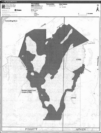
Hicks-Oke Bog Provincial Park is located approximately 40 kilometres southwest of Smooth Rock Falls and 72 kilometres northwest of Timmins (Figure 1). Hicks-Oke Bog Provincial Park was regulated under the Provincial Parks Act in December of 1994 (O. Reg. 768/94) and contains 5,880 hectares of Crown land (Figure 2).
This nature reserve class park was selected to represent distinct wetland communities within Ecodistrict 3E-1 of the province. The park may provide opportunities for education and research to benefit present and future generations.
1.1 Objectives
Hicks-Oke Bog Provincial Nature Reserve will be managed consistent with the two main objectives for nature reserve class provincial parks:
Protection: To protect provincially significant elements of the natural and cultural landscapes of Ontario.
Heritage Appreciation: To provide opportunities for exploration and appreciation of the outdoor natural and cultural heritage of Ontario.
2.0 Management context
The purpose of this Interim Management Statement (IMS) is to provide direction to ensure the custodial management of park resources. Future park planning may be undertaken as required to provide direction on significant decisions regarding resource stewardship, development, operations and permitted uses.
Park management will follow direction from:
- Provincial Parks Act (1990) and regulations
- Ontario Provincial Parks Planning and Management Policies (OMNR 1992)
- Ontario’s Living Legacy Land Use Strategy (OMNR 1999) and policy clarifications (OMNR 2000). amendments, and related direction
- Crown Land Use Policy Atlas (OMNR 2004a).
In addressing custodial management obligations to protect park values and ensure public health and safety, Ontario Parks will ensure that policy and Environmental Assessment Act (1990) requirements are implemented.
2.1 Environmental assessment
As a part of the Ontario Ministry of Natural Resources (MNR), Ontario Parks is a public sector agency which is subject to the Environmental Assessment Act. Park management will be carried out in accordance with legislation, policies, and guidelines that are required under A Class Environmental Assessment for Provincial Parks and Conservation Reserves.(OMNR 2005).
3.0 Park features and values
Hicks-Oke Bog Provincial Park protects significant organic (peatland) deposits in Ecodistrict 3E-1. The park protects bogs, fens, conifer swamps, and upland forests. The nutrient poor bogs occur on organic deposits that are one or more metres in depth. The wetland complex is considered to be provincially significant because of its size and the wide range of representative wetland ecosystems that are located in such close proximity to one another. A curious feature of the site are the 'fairy ring' sedge growth patterns that occur in the open bogs.
Figure 1: Regional Setting
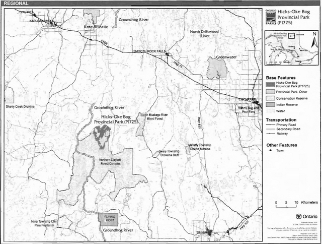
Figure 2: Park Boundary
These rings may be the southernmost known occurrence of this feature in Ontario. This wetland complex has been extensively studied (Arnup 1991).
3.1 Geological features
Hicks-Oke Bog Provincial Park is underlain by felsic igneous rocks (granitic bedrock) of early Precambrian age which are intruded with mafic intrusive diabase dykes (Arnup 1991).
The surficial geology consists of glacial lacustrine deposits from the former Barlow-Ojibway glacial lake. The sediments that make up the lacustrine deposit are banded silts and clays (Arnup 1991).
3.2 Biological features
Hicks-Oke Bog Provincial Park is located in Ecodistrict 3E-1.The lack of relief and fine grained sediments result in very poor drainage that supports wetland vegetation (Kor 2001). This park contains 16 vegetation site types, which can be broadly grouped into three categories: bogs and fens, conifer swamps, and upland forests (Arnup 1991). The bogs consist of nutrient poor open and treed wetlands with very deep organic accumulations of one or more metres. These bogs are peat-filled depressions with a high water table the surface of which is cover primarily by sphagnum mosses; they can be differentiated into the five categories of bog including treed bog, low shrub bog, dwarf shrub bog, shrub-rich bog and graminoid bog. The fens consist of peatlands of poorly to moderately decomposed peat covered mostly with sedges. Fens in this area can be grouped into four categories including treed fen, open fens, low shrub fens and shrub-rich fens. The black spruce-dominated conifer swamps typically contain Labrador tea, feather moss, speckled alder and leatherleaf. The upland areas consist of mixedwood or coniferous forests of black and white spruce, balsam fir, white birch, and trembling aspen. (Arnup 1991).
The wetland complex is considered to be provincially significant because of its size and the wide range of representative wetland ecosystems that are located in such close proximity to one another. A number of open bog structures, such as 'fairy ring' sedge features and radiating drainage channels are also present within the park. The rings are common in the northern muskegs of James Bay and the Hudson’s Bay lowlands, but uncommon in more southern regions. These rings may be the southernmost known occurrence of this feature in Ontario. This wetland complex is also significant to the scientific community and has been extensively studied in the past (Arnup 1991).
The preferred management approach is to maintain the significant ecosystems within the park in their natural state, with no active management (Arnup 1991).
3.3 Cultural setting
A detailed survey and analysis of the cultural history and features of this park has not been completed to date.
Any future planning will be within the context of a provincial framework, A Topical Organization of Ontario History (OMNR 1974). In addition, updates and discussions with First Nations, other agencies and stakeholders may be carried out to identify cultural heritage values and features within the park and their significance. This information may be used to develop management guidelines to conserve and protect representative archaeological and historical values and features, or to provide direction for further research.
3.4 Recreation
The protection and maintenance of environmental quality and values are fundamental to the management of Hicks-Oke Bog Provincial Nature Reserve. Nature reserve policies ensure that nature is allowed to function freely, within the constraints of public safety and the need to protect values within and adjacent to the nature reserve.
Wetlands may provide for some limited low-intensity recreational uses, hiking, nature viewing, photography, and fishing. Although there are no recognized canoe routes within the site, the creeks that form the boundaries of the site, may provide some canoeing/kayaking opportunities.
4.0 Aboriginal uses
Hicks-Oke Bog Provincial Nature Reserve is located within the Treaty 9 area (1905). The park is approximately 42 kilometres north of Flying Post First Nation.
First Nations have expressed interest in and have shared knowledge of the park and surrounding area. Aboriginal communities have used the area for hunting, trapping, fishing, gathering and travel. These uses may continue, subject to public safety, conservation and other considerations.
Any communications and cooperation between Aboriginal communities and the MNR for planning and operations purposes will be done without prejudice to any future discussions or negotiations between the government of Ontario and Aboriginal communities.
5.0 Stewardship policies
5.1 Terrestrial ecosystems
The removal, damage or defacing of Crown properties, natural objects, relics or artefacts is not permitted in provincial parks (Provincial Parks Act).
Non-native species will not be deliberately introduced into the park. Where non-native species are already established and threaten park values (i.e., has become invasive), a strategy to control the species may be developed (OMNR 1992).
5.1.1 Vegetation
Harvesting
Commercial forest operations are not permitted within the park (OMNR 1992).
The harvest of non-timber forest products such as club moss, Canada yew, etc., will not be permitted within the park (OMNR 1992).
Existing authorized wild rice harvesting may continue. New operations will not be permitted. There are no fuelwood cutting permits currently issued for the park. New permits will not be issued (OMNR 2000).
Insects and Disease
Insects and diseases may be managed where the aesthetic, cultural, or natural values of the park are threatened (OMNR 1992). Control measures will follow guidelines established by the Ontario Ministry of the Environment (MOE) and MNR. Whenever possible, biological control measures will be given preference over the use of chemicals (OMNR 1992).
Fire
Hicks-Oke Bog Provincial Park is located in the Boreal Zone for fire management. In accordance with existing provincial park policy and the Forest Fire Management Strategy for Ontario, forest fire protection will be carried out in the park as on surrounding lands (OMNR 2004b). Whenever feasible, MNR's Forest Fire Management program will use techniques that minimize damage to the landscape, such as limiting the use of heavy equipment or limiting the number of trees felled during response efforts (OMNR 2004b).
5.1.2 Wildlife management
Hicks-Oke Bog Provincial Park is located within Wildlife Management Unit (WMU) 30. The removal and harassment of non-game animals is not permitted (Provincial Parks Act).
Hunting
Hunting is not permitted within the park (OMNR 1992; 2000). The harvest of bullfrogs or snapping turtles is illegal in provincial parks.
Bear management areas
The majority of the park is located within an unallocated bear management area (BMA). However, a few sections of the park appear to be located within BMA licence area KA-30-002 (Figure 3). The boundary of this BMA licence was amended to exclude the park from the BMA license area following regulation of the park.
Existing BMAs are not compatible with nature reserve class parks (OMNR 1992; 2000; 2003). New BMA licences will not be permitted (OMNR 2000; 2003).
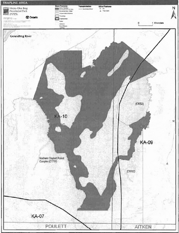
Trapping
The park includes portions of two licensed traplines including: KA-09 and KA-10 (Figure 4). During the transfer of trapline license KA-10 in 2006, an agreement was signed between MNR and the trapline licensee, indicating that trapping within the park will cease on January 1, 2010.
Transfers of active trap line licenses are not permitted. New operations, including trap line cabins and trails, will not be permitted (OMNR 2003).
5.1.3 Industrial resources
There are no existing mining claims within park. The mining and surface rights on all lands within the park have been withdrawn from staking under the Mining Act (1990). Mineral exploration and mining are not permitted in the park.
5.1.4 Access and crossings
Access and roads
C.S.R. #8 Road provides access to the northwestern portion of the park (Figure 3). Portions of this secondary road are included within the park boundary.
Where this existing forest access road is essential for continued access beyond the park for forest management or recreation purposes, and alternative road access does not exist, or road relocation is not feasible, this road will continue to be available for access. Continued use will include maintenance and may include upgrades (OMNR 2004a). Ontario Parks will work with the Sustainable Forest License holder in this area to relocate the road outside the park. Ontario Parks is not responsible for the maintenance or upgrade of any roads within the park boundary.
Any proposed development, maintenance or upgrading of existing roads must meet all Environmental Assessment Act requirements.
The development of new roads will not be permitted within the park (OMNR 2004).
Figure 3: Bear Management Areas
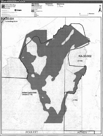
Figure 4: Trap Line Areas
Utility corridors
There are no utility corridors located within the boundary of this park.
All public utilities (e.g., gas pipelines, transmission lines, communications towers) must avoid park lands wherever possible. New utility corridor crossings may be necessary to maintain essential public services (OMNR 2004a).
Any future utility corridors proposed through the park, where park lands are unavoidable, will be reviewed on a case-by-case basis. Protection of park features and values will be priority and all requirements of the Environmental Assessment Act will be met.
Recreational trails
There are no authorized hiking, snowmobile or ATV trails within the park. New trails for ATV and snowmobile use will not be permitted within the park due to the sensitive nature of peatland. New trails (e.g., hiking) may be developed if the need arises. Any proposed development within the park is subject to Environmental Assessment Act requirements.
5.1.5 Adjacent land management
Forestry
The land adjacent to the park is located within the Gorden Cosens Forest Management Unit (#438). The Gordon Cosens Forest Management Unit is currently managed by Spruce Falls Incorporated, a subsidiary of Tembec Incorporated. The management plan will be in effect from 2005 to 2025. Operations will be in effect until 2010 (OMNR 2006).
Management of adjacent lands may impact this nature reserve class park. Roads constructed in the immediate vicinity of the park may interrupt the natural drainage of the area and consequently adversely affect the ecosystem. It is recommended that roads constructed adjacent to the park be aligned parallel to creeks and linear alder swales in order to minimize impacts on the natural drainage of the nature reserve. It is also recommended that forest harvesting operations in wetlands immediately adjacent to the park be undertaken in the winter months while the ground is frozen to minimize ground disturbance and consequently disturbance in natural drainage of the park (Arnup 1991).
General use area
There is one general use area, Kapuskasing Resource Extraction Area (G1736), directly adjacent to Hicks-Oke Bog Provincial Nature Reserve. The general use area is 1,410,036 hectares in size and surrounds the northern portion of the site. The extraction of natural resources will be encouraged in this area. Management priorities include forest management, fur management, mineral and aggregate programs. Water storage for hydro electric power generation is also a priority. This area provides an environment where recreational activities such as hunting, fishing. camping, and cottaging can take place. Commercial tourism is also an important use in this area; any road construction and use, must take into account this use on the landscape.
Conservation reserve
There is one conservation reserve, Northern Claybelt Forest Complex Conservation Reserve (C1702), directly adjacent to Hicks-Oke Bog Provincial Nature Reserve. This conservation reserve is 68,128 hectares in size and surrounds the southern portion of the site. This area, which contributes toward biological diversity in Ontario, protects ecosystems that are characteristic of the Northern Claybelt Forest. Dominant representative features within this site include a lacustrine deposit with dense coniferous forest, mixed coniferous forest, and fen. The area contains an abundance of peatlands which serve to enhance the existing Hicks-Oke Bog Provincial Nature Reserve with its variety of bog formations. This site includes portions of two provincially significant life science sites: the Nat River Uplands contains stands of old growth poplar/aspen, spruce and white birch over two different bedrock formations, and a portion of Enid Creek surrounded by young and old growth spruce on two different landform types.
Provincial park
There is one provincial park, Groundhog River Provincial Park (P1569), located near Hicks-Oke Bog Provincial Park. This park is 13,960 hectares in size and is located west of the nature reserve park. This highly diverse park is representative of approximately 22 different landform vegetation combinations. The dominant landform types present are weakly broken ground moraine and lacustrine deposit. Dominant vegetation types include mixed conifer and mixed deciduous forests. The Groundhog River contains excellent sturgeon fisheries, and brook trout feeder streams.
5.1.6 Land disposition
New land disposition for the private use of individuals or corporations will not be permitted (OMNR 1992; 2000).
Land use permits, licenses of occupation, unauthorized occupations
There are no existing land use permits (LUP), private land holdings, licenses of occupation (LO) or unauthorized occupations within the park.
Patent land
There are no patent lands surrounded by or adjacent to the park boundary.
Boat caches
There are no authorized boat caches within this provincial park. Boats are not permitted to be left unattended in the park without written permission from the superintendent under the authority of the Provincial Parks Act.
5.2 Aquatic ecosystems
Sustaining quality water resources is integral to the protection of park and adjacent land values. The MOE enforces applicable legislation and regulations for water quality.
5.2.1 Water management
There are no existing water control structures within the park. New commercial hydroelectric developments will not be permitted within the park (OMNR 1992; 2000; 2004a).
5.2.2 Fisheries management
The park contains a variety of wetlands including bogs and fens and conifer swamps as well as Hicks Creek and a portion of South Creek. Fisheries management will complement the maintenance and enhancement of native, self-sustaining fish populations (OMNR 1992).
Sport fishing
Sport fishing is permitted within Hicks-Oke Bog Provincial Park (OMNR 1992; 1999; 2004a). Any sport fishing activity is governed by the legislation and regulations in the Fish and Wildlife Conservation Act (1997), as well as the Fisheries Act (1985). The Recreational Fishing Regulations Summary contains more information regarding general regulations and exceptions to these regulations for the area of this park.
Commercial fishing
There are no commercial fishing operations within Hicks-Oke Bog Provincial Nature Reserve. New operations will not be permitted (OMNR 1992; 2004a).
Commercial baitfish harvesting
Hicks Township is not currently allocated for baitfish harvesting (Figure 5). The portion of Hick’s Township baitfish license (HE 0021) within the park boundary will be removed from the baitfish license area. Oke Township is currently allocated for baitfish harvesting under licence HE 0022, however the waters within the park have been excluded from the baitfish licence harvest area.
Baitfish harvesting is not a compatible use within a nature reserve class park (OMNR 1992). Existing use must be phased out before or by January 1, 2010 (OMNR 2003; 2004a). Transfers of existing baitfish harvesting operations within the park area are not permitted. New baitfish licenses will not be permitted (OMNR 2000; 2003).
Figure 5: Baitfish Harvest Areas

Fish stocking
Fish stocking is not permitted in the park (OMNR 1992).
6.0 Operations policies
6.1 Recreation management
6.1.1 Motorized recreation
Motorboats
Motorized watercrafts are not permitted within the park (OMNR 1992; 2004a).
Aircraft
Aircraft landings are not permitted within the park (OMNR 1992; 2004a).
Snowmobiles
There are no authorized snowmobile trails within the park however, there may be some existing use along the C.S.R. #8 Road. This existing use will be permitted to continue unless this use threatens park values. The development of snowmobile trails within the park is not compatible with nature reserve policies (OMNR 1992). Proposals for new trails will not be considered. Offtrail use of snowmobiles is prohibited.
All terrain vehicles
There are no authorized ATV trails within the park however, there may be some existing use along the C.S.R. #8 Road. This existing use will be permitted to continue unless this use threatens park values. The development of ATV trails within the park is not compatible with nature reserve policies (OMNR 1992). Proposals for new trails will not be considered. Off-trail use of ATVs is prohibited.
6.1.2 Non-motorized recreation
Camping
There are no designated campsites within the park. Overnight camping and the development of campground or campsite facilities are not compatible with nature reserve policies (OMNR 1992; 2004a). The development of new campsites and campgrounds is not permitted (OMNR 1992).
Hiking
There are no authorized hiking trails within the park. Unauthorized hiking trails and other non-mechanized trails may be permitted to continue unless such trails threaten park features and values, create user conflicts or raise safety and/or liability issues.
If there is an identified need, the development of new hiking trails may be considered. Trail infrastructure to protect park values and features will be permitted. Any proposed development within the park is subject to Environmental Assessment Act requirements.
Canoeing / Kayaking
There is no specific canoe route associated with this park, however, there may be some canoeing and/or kayaking occurring within the park. Existing uses may continue, unless park values are threatened. Infrastructure to protect park features and values may be permitted and developed in response to use, environmental deterioration and environmental protection requirements. Longterm management direction will be determined through future park planning (OMNR 2004).
6.1.3 Emerging recreational uses
There are emerging recreational uses for which there is no or limited policy to deal with their management (e.g., adventure racing, geocaching, etc.). The park superintendent will use legislation, policy and guidelines that are in place in the interim to manage emerging uses.
6.2 Development
There is no existing park infrastructure within this park. Any proposed development within the park will only be considered through future park management planning. Any proposed development is subject to the requirements of the Environmental Assessment Act.
6.3 Commercial tourism
Infrastructure for commercial tourism (outfitting, outpost camps etc.) does not exist within the park. Commercial tourism operations are not compatible with the nature reserve classification of this park (OMNR 1992; 2000). New commercial tourism dispositions (i.e. commercial LUPs) will not be issued within the park (OMNR 1992; 2004a).
7.0 Cultural resources
The management of any cultural resources will be directed toward identification, protection, and heritage appreciation (OMNR 1992). Cultural resource surveys of Hicks-Oke Bog Provincial Nature Reserve have not been completed to date.
8.0 Heritage education
Literature and other supporting information may be developed to describe the park in the context of Ontario’s provincial park system. Boundary limits, significant heritage features and permitted uses of the may be included in park literature.
Prospective park visitors may be informed about the sensitivity and significance of park values through park literature.
9.0 Research
Scientific research by qualified individuals which contributes to the knowledge of natural or cultural history, or to environmental or recreational management, may be encouraged in the park. Ontario Parks will encourage institutions, such as universities, to undertake research projects.
All research programs will require the approval of Ontario Parks and are subject to park policy and other applicable legislation. Any materials removed from the park will remain the property of Ontario Parks.
Approved research activities and facilities will be compatible with the park’s protection objective. Any site which is affected by research will be rehabilitated as closely as possible to its original state. Environmental Assessment Act requirements will apply.
10.0 References
Arnup, R.W., 1991. Report on Reconnaissance Life Science Inventory for Hicks-Oke Townships Wetlands Area of Natural and Scientific Interest (ANSI). Ecological Services for Planning Limited for the Ontario Ministry of Natural Resources.
Environmental Assessment Act, 1990.
Fisheries Act, 1985.
Fish and Wildlife Conservation Act, 1997.
Kor, P.S.G., 2001. Earth Science Inventory Checklist- Northern Claybe/t Forest Complex C1702. Ontario Ministry of Natural Resources.
Mining Act, 1990
Ontario Ministry of Natural Resources, 1974. A Topical Organization of Ontario History. Historic Sites Branch Division of Parks.
Ontario Ministry of Natural Resources, 1992. Ontario Provincial Parks Planning and Management Policies, 1992 Update.
Ontario Ministry of Natural Resources, 1999. Ontario’s Living Legacy Land Use Strategy.
Ontario Ministry of Natural Resources, 2000. Ontario Provincial Park Policy as Amended by the Ontario Living Legacy Land Use Strategy.
Ontario Ministry of Natural Resources (OMNR), 2003. Directions for Commercial Resource Use Activities in Provincial Parks and Conservation Reserves. 5 pp.
Ontario Ministry of Natural Resources, 2004a. Crown Land Use Policy Atlas.
Ontario Ministry of Natural Resources, 2004b. Forest Fire Management Strategy for Ontario. Aviation and Fire Management Branch.
Ontario Ministry of Natural Resources, 2005. A Class Environmental Assessment for Provincial Parks and Conservation Reserves.
Ontario Ministry of Natural Resources, 2006. List of Forest Management Units (MU) in Ontario (2006/2007) (designated under the Crown Forest Sustainability Act, Section 7) All Management Units effective as of April/1, 2006. Accessed December 29, 2006. http://ontariosforests.mnr.qov.on.ca/spectrasitesNiewers/showArticle.cfm?id=C74F77D4-68C7-41A6-8D96FB6079073782&method=DISPLAYFULLNOBARNOTITLE R&ObjectiD=C74F77D4-68C7-41A6-8D96FB6079073782&1anq=FR&Ianq=EN&Ianq=FR&Ianq=EN [Link no longer active]
Provincial Parks Act, 1990.
Appendix A: Background information
| Name | Hicks-Oke Bog Provincial Nature Reserve |
|---|---|
| Classification | Nature Reserve |
| Eco-Region/Eco-District | 3E-1 |
| OMNR Administrative Region/District | Northeast/Hearst |
| Total Area (ha) | 5,880 |
| Regulation Date | December 1994 (O. Reg.768/94) |
Representation
Earth science
Hicks-Oke Bog Provincial Nature Reserve is underlain by felsic igneous rocks (granitic bedrock) of early Precambrian age with some mafic intrusive dykes (diabase dykes) which run in an north/south direction (Arnup 1991).
The surficial geology consists of glacial lacustrine deposits from the former Barlow-Ojibway glacial lake which followed the retreat of the Winsconsinan ice sheet. The sediments that make up the lacustrine deposit are banded (varved) silts and clays and may range from 2 to 12 meters in depth over the granitic bedrock (Arnup 1991). The lack of relief, and fine grained sediment, have produced an area of very poor drainage which consists of wetland vegetation.The area is considered to be highly sensitive to damage from most uses due to the clay substrate, poor drainage and very delicate surficial features (Kor 2001).
Life science:
Hicks-Oke Bog Provincial Nature Reserve is located in Ecodistrict 3E-1. This park contains 16 vegetation site types which can broadly be grouped into 3 categories including: bogs and fens, conifer swamps and upland forests (Arnup 1991).The bogs and fens consist of nutrient poor wetlands with very deep organic accumulations of one or more metres. Bogs are peat-filled depressions with a high water table with a surface cover of primarily sphagnum mosses. The bog surface may form raised hummocks separated by wet depressions or simply form a flat and level surface. Arnup (1991) subdivided the bog into the five categories, including treed bog, low shrub bog, dwarf shrub bog, shrub-rich bog and graminoid bog. The fen consisted of peatlands of poorly to moderately decomposed peat covered mostly with sedges. Arnup (1991) subdivided these fens into the following categories including treed fen, shrubby fens and open fens. Open bogs and fens within the provincial park contain deeper peat than the treed bogs and fens (Arnup 1991).
The black spruce-dominated conifer swamps typically contain Labrador tea, feather moss, speckled alder and leatherleaf. These swamps are influenced by the minerotrophic waters of adjacent uplands and contain organic accumulations of 30 or more centimetres (Arnup 1991).
The upland areas consist of mixedwood or coniferous forests of black and white spruce, balsam fir, white birch, and trembling aspen, which have developed on mineral soils capped with shallow organic accumulations of less than 30 centimetres (Arnup 1991).
There is likely limited use of this area by local wildlife. The nutrient poor nature of the site does not provide optimal foraging habitat for moose and other wildlife. Trapping records indicate there are some fur bearing mammals in the area, however they are likely more prevalent in adjacent upland areas. Some small mammals and birds might nest and forage in the area though they are likely more common in the surrounding forest (Arnup 1991) Should woodland caribou be present in this area, they would likely use this area for predator avoidance. The sandhill crane is another species that prefers breeding in this type of environment and could use the area should it be present (E.D. Morris, Personal Communication, January 9, 2007).
The wetland complex is considered to provincially significant because of its size and the wide range of representative wetland ecosystems that are located in such close proximity to one another. A number of open bog structures, such as 'fairy ring' sedge features and radiating drainage channels are also present within the park. These rings are common in the northern muskegs of James Bay and the Hudson’s Bay lowlands, but uncommon in more southern regions. These rings may be the southernmost known occurrence of this feature in Ontario. This wetland complex is also significant to the scientific community and has been extensively studied in the past (Arnup 1991).
The preferred management approach is to maintain the significant ecosystems within the park in their natural state, with no active management (Arnup 1991).
Management of adjacent lands may impact this nature reserve class park; peatlands include a diverse range of wetland types, all of which develop in response to specific local hydrological conditions. Roads constructed in the immediate vicinity of the park may alter the natural drainage pattern, resulting in significant effects to the peatland wetlands. Roads that are further away are less likely to affect the wetlands. Roads that are aligned parallel to creeks and linear alder swales should minimize impacts on the natural drainage pattern. Forest harvesting operations conducted when the ground is frozen are more likely to minimize ground disturbance, and consequently natural drainage patterns should be less affected (Arnup 1991).
Cultural heritage:
There are currently no reports describing the cultural heritage of Hicks-Oke Bog Provincial Nature Reserve.
Recreation and tourism:
There is currently no recreational inventory for Hicks-Oke Bog Provincial Nature Reserve. Wetlands provide limited potential for recreational pursuits which may include hiking, nature viewing, solitude, photography, and fishing.
Inventories
| Survey Level | Earth Science | Life Science | Cultural | Recreational |
|---|---|---|---|---|
| Reconnaissance | Arnup, 1991 | Arnup, 1991 | N/A | N/A |