Hilliardton Marsh Conservation Reserve Management Statement
This document provides policy direction for the protection, development and management of the Hilliardton Marsh Conservation Reserve and its resources.
Statement of Conservation Interest
December 2002
Kirkland Lake District
Ministry of Natural Resources
1.0 Introduction
Ontario’s network of natural heritage areas has been established to protect and conserve areas representative of the diversity of the natural regions of the province, including species, habitats, features and ecological systems which comprise that natural diversity. Protected natural heritage areas are a key component in sustainable management of natural resources. They ensure that representative sites within the larger sustainable managed landscape are permanently retained in their natural state.
Natural heritage areas are considered to be sensitive, requiring protection from incompatible activities if their values are to endure over time. The Ministry of Natural Resources has established conservation reserves as a new tool to offer protection for these areas on public lands, while permitting many traditional public uses to continue. Such uses include the traditional activities of Aboriginal peoples.
Ontario’s Living Legacy Land Use Strategy (LUS MNR, 1999) sets the direction for the administration and management of parks and protected areas on Crown lands within three planning regions including; the Boreal West, Boreal East and Great Lakes- St. Lawrence areas. This strategy’s natural heritage objectives include protection of natural and cultural heritage values and the provision of opportunities for outdoor recreation, heritage appreciation and tourism (MNR, 1999).
Protected areas designated within the OLL LUS have been selected based on their representation of the spectrum of the province’s ecosystems and natural features including both biological and geological features, while minimizing impacts on other land uses. Representation was described using landform and vegetation combinations based on Hill’s (1959) site district concept. For the Hilliardton Marsh Conservation Reserve (C1704), lacustrine deposits with mixed deciduous forest, mixed coniferous forest and sparse forest occupy the site. The area also contains numerous wetlands, which provide excellent habitat for waterfowl.
The Hilliardton Marsh Conservation Reserve is composed of many different parcels of Crown land in the townships of Ingram, Pense, Hilliard, Brethour, Harley, and Casey (Locator Map, Appendix 7). The conservation reserve, which is situated within the OLL Boreal East Planning Region, has an area of 5,787 hectares. These townships are situated in the Kirkland Lake District within the MNR's Northeast Region. The conservation reserve will be managed under a Statement of Conservation Interest (SCI).
Statement of Conservation Interest (SCI) documents are the minimum level of management direction established for any conservation reserve and generally are brief management plans. This SCI will govern the lands and waters within the regulated boundary of the Hilliardton Marsh Conservation Reserve. However, to ensure MNR protection objectives are being fully met within this conservation reserve, the surrounding landscape and related activities should consider the site’s objectives and heritage values. In addition, it is the intent of this SCI to create public awareness that will promote responsible stewardship of protected areas and surrounding lands. With management partners such as Ontario Parks, industry and local governments. MNR District staff will be able to pursue and advance sound environmental, economic and social strategies and policies related to the protection of conservation reserves and provincial parks.
The purpose of this SCI is to identify and describe the values of the Hilliardton Marsh Conservation Reserve and outline the Ministry’s management intent for the conservation reserve. The management direction will protect the site’s natural heritage values and demonstrate its compatibility within the larger sustainable landscape. This direction will comply with land use intent as stated by the OLL Land Use Strategy (MNR, 1999).
2.0 Goals and objectives
2.1 Goal of Statement of Conservation Interest
The goal of this SCI is to describe and protect natural heritage values on public lands while permitting compatible land use strategies.
2.2 Objectives of SCI
2.2.1 Short term objectives
The short-term objectives are to identify the State of the Resource in terms of natural heritage values and current land use activities for the Hilliardton Marsh Conservation Reserve. A priority will be placed on the protection of the site’s natural values via specific guidelines, strategies and prescriptions detailed in this plan. Finally legislated planning requirements will be met (e.g. SCI development within three years of regulation).
2.2.2 Long term objectives
The long-term objectives will be to establish representative targets (e.g. future forest conditions) and validate the site as a potential scientific benchmark. To ensure protection of natural and cultural heritage features and values, this SCI will establish an evaluation process to address future new uses and commercial activities associated with them (e.g. Test of Compatibility Procedural Guideline B in Conservation Reserve policy PL 3.03.05). Finally, this SCI will identify research/client services and marketing strategies.
3.0 Management planning
3.1 Planning area
The planning area for this site will consist of the area within the regulated boundary for the Hilliardton Marsh Conservation Reserve (Locator Map, Appendix 7).
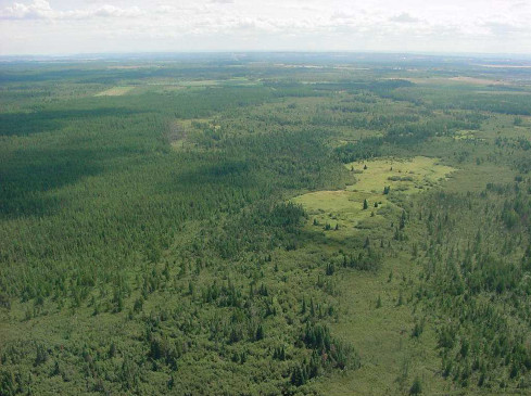
Figure 1.0 - Typical view of one of the areas in the northern portion of this site. From the photo you can see the different types of wetlands. From open areas of sphagnum moss to the more dense black spruce swamps. Photo taken by Craig Fuller on August 18, 2001.
This landbase will form the area directly influenced by this Statement of Conservation Interest. The SCI will recognize the protection of values within the planning area; however, to fully protect values within the conservation reserve, the lands beyond the regulated boundary may require additional consideration within larger land use or resource management plans. Nevertheless, any strategies noted within this plan related to the site’s boundary or beyond will need to be presented for consideration within a larger planning context.
3.2 Management planning context
The Hilliardton Marsh Conservation Reserve was first designated as a candidate conservation reserve by MNR in the OLL Proposed Land Use Strategy (MNR, March 1999) and ultimately as a conservation reserve in the final OLL Land Use Strategy (MNR, 1999). The site was regulated under an amendment of Ontario regulation 805/94 made under the Public Lands Act on May 8, 2002. Management and planning direction for this site will follow the OLL LUS (MNR, 1999) and this management statement. The area encompassed by this site has also been removed from the Timiskaming Forest Alliance Inc. Sustainable Forest License (SFL) landbase.
By regulation this conservation reserve cannot be used for commercial forest harvest, mining or hydroelectric power development. Currently no mining tenure exists within the site and the site has been withdrawn from staking under the Mining Act. Existing recreational activities within this reserve may continue such as sport hunting and fishing. This SCI document and future management of the site will continue to try to resolve conflicts regarding incompatibility between uses and to ensure that identified values are adequately protected.
This SCI will only address known issues or current proposals with respect to permitted uses or potential economic opportunities brought forward to the District Manager during this planning stage. However, in terms of approving future permitted uses and/or development(s), there are established mechanisms in place to address such proposals. Any future proposals will be reviewed using the Procedural Guideline B – Land Uses –Test of Compatibility Public Lands Act Policy PL 3.03.05 (MNR, 1997) or other standard MNR environmental screening processes.
Consideration of proposals pertaining to cultural resources may be screened through Conserving a Future for our Past: Archaeology, Land Use Planning & Development in Ontario, Section 3 (MCzCR, 1997), or in processes such as that used by MNR to establish AOC descriptions and prescriptions for cultural heritage resources within forest management plans (FMPs).
These planning tools will help refine the review process once the proposal satisfies the direction and intent of the Public Lands Act, associated policies and this planning document.
3.3 Planning process
Once a conservation reserve is passed into regulation, it must be determined what level of management planning is required to fulfill the protection targets. There are two policy documents involved. A Statement of Conservation Interest (SCI) is the minimal requirement for providing planning direction, and a Resource Management Plan (RMP) that deals with more complex issues where several conflicting demands are placed on the resources. The guidelines for the preparation of these documents are outlined in Procedural Guideline A – Resource Management Planning (Conservation Reserves Procedure PL3.03.05 Public Lands Act). The appropriate plan for a site must be completed within three years of the regulation date.
For current planning purposes, the Hilliardton Marsh Conservation Reserve will be managed under the auspices of a Statement of Conservation Interest. Interested parties from both the private and public sectors were consulted during the OLL boundary refinement process from candidate conservation reserve to regulation. The intent of this SCI is to fulfil the commitments made within the OLL LUS (MNR, 1999). In addition to the boundary consultation, a public notification and review of a draft of this SCI document occurred for a period of 30 days during August/September, 2002. During this period, the MNR received no new permitted use or development proposals for this conservation reserve. Therefore, no new decisions have been identified by the MNR since the implementation of the OLL strategy.
The revised SCI was reviewed by the Kirkland Lake District Manager (DM). Upon approval by the DM the SCI was presented to the Regional Director (RD) for final approval.
Following RD approval, interested public, user groups and industry were notified that the Statement of Conservation Interest for the Hilliardton Marsh Conservation Reserve was approved.
Public consultation will be solicited during a review of any future land use proposals that would require new decisions to be made. In addition, any future proposal and/or any new, significant management direction considered will be published on the Environmental Bill of Rights Registry (EBR).
The SCI is a planning document that will provide background information, identify values to be protected and establish management guidelines for use in the administration of the reserve.
The implementation of the SCI will be the mandate of the MNR at the district level; however, associations with various partners may be sought to assist in the delivery. This SCI is a working document; therefore it may be necessary to make revisions to it from time to time.
4.0 Background information
4.1 Location and site description
4.1.1 Location
The following table describes the location and provides administrative details of the site:
| Name | Hilliardton Marsh Conservation Reserve |
|---|---|
| Site Region – Site District (Hills) | 4E/5 |
| Site Region – Site District (Crins and Uhlig) | 4E/5 |
| MNR Administrative Region/District/Area | Northeast Region/Kirkland Lake District in the Kirkland/Claybelt Area |
| UTM Ref.. | 970 850 |
| Nearest Town/Municipality | Located within the Corporation of the Townships of Hilliard, Brethour, Harley and Casey |
| Township(s) | Ingram, Pense, Hilliard, Brethour, Harley and Casey |
| OBM Numbers | 590 52900/ 600 52900/ 590 52800/ 600 52800/ 600 52700/ 610 52700 |
| Topographical Map Name/Number | 31 M/13 and 31 M/12 |
| Wildlife Management Unit | 28 |
| Forest Unit | Timiskaming Forest |
4.1.1.2 Site description
4.1.2.1 Physical description
The key values within the conservation reserve include the following:
- old growth eastern white cedar and black spruce
- undisturbed forest communities
- wetlands, including bogs, fens, swamps and marshes
The majority of the site is located on an organic surface. Coniferous forests such as black spruce, larch and cedar have developed on this organic soil. Towards the southeastern section of the site there are a few exposed bedrock outcrops covered predominately by poplar mixed wood communities. Due to the wetter characteristics of this site some of the more predominant features include wetland vegetation. The northeastern portion of the site is covered with eastern white cedar that are 143 to 183 years old and black spruce old growth communities ranging from 108 to 132 years old as indicated on the forest resource inventory for 2002.
4.2 Administrative description
The legal boundaries of the Hilliardton Marsh Conservation Reserve were filed on January 11, 2001 in the Office of the Surveyor General, Ministry of Natural Resources in Peterborough, Ontario. The site was regulated on April 6, 2001. The conservation reserve is located within the Timiskaming Forest.
4.3 History of site
Historically the area has been used for farming activities including cereal crops, hay as well as pasture land. This area, referred to as the Little Clay Belt in the early 1900s, had most of the wetlands drained for agricultural development. This is clearly evident on aerial photographs of the area. Numerous drainage ditches, some running through portions of the Conservation Reserve, are visible.
The parcels of Crown land that were not purchased and cleared for farming make up what is now referred to as the Hilliardton Marsh Conservation Reserve. This reserve consists of 20 separate parcels separated by roads and private parcels of land.
The site contains portions of 3 Bear Management Areas, 2 baitfish blocks as well as 3 traplines. In addition to this there are also private land trappers in the area.
Also in close proximity to the site are two Ducks Unlimited (DU) projects initiated to aid in restoring wetland habitat for waterfowl as well as increasing biodiversity. The larger of the two projects, the Hilliardton Marsh Provincial Wildlife Area, which shares the name of this conservation reserve. It was started in 1993 and is 728 hectares in size. The other DU project is considerably smaller and is located in Casey Township and is referred to as the Casey Marsh.
4.4 Inventories
The following table indicates the current status of natural heritage inventory that has occurred or is required in the near future. Further information on the inventory data that has been completed is located in the appendices or section 5.0 or this document.
| Survey Level | Earth Science | Life Science | Cultural | Recreational | Other |
|---|---|---|---|---|---|
| Reconnaissance | August 2001 | August 2001 | Not required at this time. | June/July 2001 August 2001 Summer 2002 |
|
| Detailed | |||||
| Requirement | Additional life science inventory to define values is required. |
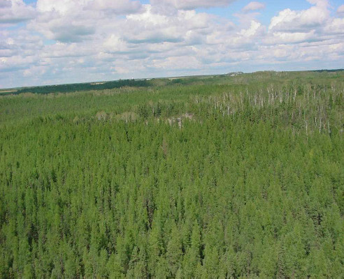
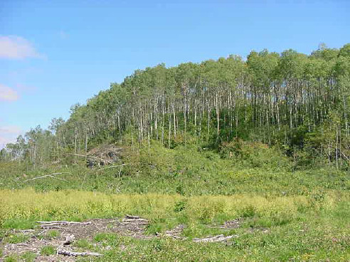
Figure 2.0 - View looking north-east over a northern section of the Conservation Reserve. Shows one of the rock outcrops associated with portions of this site and the transition from black spruce and larch on the wetter portions to poplar and white birch associated with the drier upland rock outcrop. Photo taken August 18, 2001 by Craig Fuller.
5.0 State of the resource
Representation:
Hilliardton Marsh Conservation Reserve is located in the townships of Ingram, Pense, Hilliard, Brethour, Harley and Casey. The conservation reserve is made up of 20 separate parcels separated by roads and private patented parcels of land. The protected area is situated in Hills’s New Liskeard site district 4E-5, which is characterized by an undulating clay plain enclosed by rolling Precambrian ridges with shallow mantles and deep pockets of silt, sand and locally clay (Hills 1959). This clay plain is known by various names, among which the Little Clay Belt and Haileybury Clay Plain are probably the most common. Hills describes the clay plain proper as broad flats of deep silt and clay often overlain by peat in the valleys of the Blanche River.
The site’s regional forest climate is mid-humid, warm boreal with well-drained glacial deposits, which occupy the hill slopes and basins, with peatlands restricted to local wet plains and depressions. A broken area of gently sloping uplands and moderate broad valleys of sand and silt characterize the site district. Many species characteristic of this transition region reach their northern distribution limits in this site region (Poser 1992). Hilliardton Marsh Conservation Reserve is located within the Haileybury Clay forest region. Here the forest are transitional in nature, with close affinities to those of the Northern Clay Section but also strongly influenced by the more southern hardwood species, especially in the vicinity of Lake Temiskaming. Black spruce communities are characteristic on lacustrine flats but continual cutting has reduced their areas of distribution. Associated with the spruce are balsam fir, white birch and trembling aspen (poplar). The prominence of the latter two species is greatly increased as the result of wildfires. On moist flats and river banks, stands of balsam poplar of large size are found, as well as old-growth eastern white cedar. White spruce is not abundant and is distributed mainly along rivers and lakeshores, and on well-drained slopes. Surface drainage is generally poor and organic soils occupy a large percentage of the area. Much of the upland has been cleared for cultivation, and the extent of the natural forest has been further reduced by past fires. Gray luvisols and humo-ferric podzols are typical of the well-drained sites, with humic gleysols and organic soils on poorly drained sites (Rowe 1972).
Quality of representation:
The quality of the representation for the current characteristics of the natural features found within the conservation reserve are as important as the overall representative features that are being protected. A number of factors are considered in evaluating a site and they include the following criteria; diversity, condition, ecological factors, special features and current land use activities.
a) Diversity:
Diversity is a measure of the site’s life and earth science heterogeneity. The evaluation is based on the number and range (variety) of the natural landscape features and landforms for earth science values and the relative richness and evenness of the site’s life science components. There are three major landform or earth science features present in the site:
- organic
- alluvial and
- glaciolacustrine deposits.
Life science diversity is demonstrated by a minimum of 61 landform: vegetation combinations.
This diversity, which is based on the number of vegetation cover types, is high for such a fractured site. Overall, the site is dominated by black spruce and larch forest communities overlying the extensive areas of organic deposits. However, most forest stands observed during the aerial reconnaissance survey in 2001 contained a wide assemblage of tree species. Wetland and aquatic values added considerably to the site’s diversity. Overall, the number of communities present within this fractured site, the large wetland communities and the large old growth forest stands all contribute to the site’s high life science diversity rating. By protecting the full diversity of the landforms in the conservation reserve, a greater diversity of vegetation types and plant and animal species is to be expected. The faunal diversity of the site is likely typical for the boreal region. However, a more definitive assessment of both floral and faunal diversity cannot be made at present, given that this was a reconnaissance level survey. A full biological inventory and evaluation would provide a more complex species list.
b) Condition:
Disturbance is ranked moderate to high for this site. The site’s life science features are poorly protected because of the fractured nature and human disturbance on portions of the site. The complex land tenure in the surrounding area minimizes the control over land uses that could disrupt the moisture regime of this site and subsequently the vegetation. In addition, the agricultural activities in the surrounding landscape could affect the ecosystems present within the conservation reserve. Small portions of the reserve have been cleared for agricultural activities in the past and are now in the process of regenerating naturally.
The site contains little recreational potential; however, the site could have a significant interpretation role in the wetland ecology of this area and site district. Also, there are several drainage ditches throughout the surrounding properties and in several of the protected parcels. Two small communities; Hilliardton and Belle Vallee are situated in the middle of the conservation reserve.
c) Ecological factors:
The site is defined by vectored boundaries with many of the landforms and forest communities extending beyond the site’s borders. The site is made up of 20 separate parcels divided by roads and private patented parcels of land. Access to the site and to the interior of the parcels is readily available due to numerous roads and trails. Furthermore, several drainage ditches are present throughout many of the parcels within the protected area. In the future ground surveys should confirm the level of disturbance to the site and in the large agricultural areas immediately surrounding the site. The conservation reserve may be sensitive to some of the existing land uses due to the peripheral drainage for agricultural practices. This practice may eventually change the moisture regime of this site and subsequently alter the vegetation communities (Noble 1981). Additional protection of the conservation reserve’s values may have to occur outside the site, during larger scale management planning exercises (FMPs).
d) Special Features:
There are several interesting features that make this site an excellent candidate as an addition to the protected areas system. The extensive wetlands throughout the site and the large old growth stands in the northeastern portion are special features that enhance the site’s life science diversity. Also, the Blanche River bisects the parcels into east and west.
In addition, the northern portion of the site contains large intact forest communities in an otherwise very disturbed environment. The site contributes undisturbed forest stands and wetlands, which are valued within the heavily disturbed Site District 4E-5. Furthermore, Casey Mountain, which contains interesting forest communities and landforms, is located outside of the boundaries near a parcel in the most southern portion of the conservation reserve.
e) Current land use activities
Only a small number of current uses are known to be directly associated with this site. Activities include trapping, hunting, baitfish harvesting and snowmobiling.
The neighboring Hilliardton Marsh Wildlife Area has an open season for waterfowl three days of the week during the migratory game bird season. A number of moose and bear hunters use parts of the conservation reserve for big game hunting.
Part of the Ontario Federation of Snowmobile Clubs' (OFSC) trails run through and adjacent to sections of the conservation reserve as well as in close proximity to others. These trails use existing roads and trails that are abundant throughout the parcels of the reserve.
Another activity that takes place in the area is birding. This consists of songbird mist netting, owl and duck banding as well as general birding to identify species in the area. Data is compiled on the numbers, species and sex of birds captured and banded in the area.
Summary:
Hilliardton Marsh Conservation Reserve was described in the OLL Land Use Strategy as protecting representative features within this site district including, lacustrine deposit with mixed deciduous forest, mixed coniferous forest, and sparse forest. The area also contains wetlands, which provide excellent habitat for waterfowl. The site was identified as regionally significant because of the peat flats over clay plains in the Blanche River Valley, and associated vegetation (Noble 1981). Furthermore, the Hilliardton Marsh Conservation Reserve is probably of provincial significance due to the features present within the boundaries. Regardless of the earth or life science values currently present, the site does contribute some undisturbed forest stands and wetlands which are valued within the heavily disturbed Site District 4E-5. Some of the features captured within the site are not found in any other park in the site district. Kap-Kig-Iwan Provincial Park provides some representation for the clay plain and additionally the rock fringe areas as the park straddles the boundary between the two units. However, the elements captured by the conservation reserve are the peat overlying clay and silt, which are most prevalent in the valleys, of the Blanche River. The Hilliardton Marsh Conservation Reserve provides representation of unique biophysiographic landscapes in site district 4E-5. The largest peat flats are located on either side of the Blanche River. The peat flat protected by Ducks Unlimited Hilliardton Swamp is situated on the west side of the river.
Figure 3.0 - View of one of the OFSC trails running through a portion of one of the parcels of the Hilliardton Marsh Conservation Reserve in Brethour Township. Photo taken August 2002 by Craig Fuller.
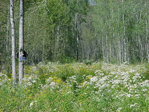
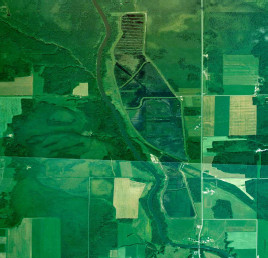
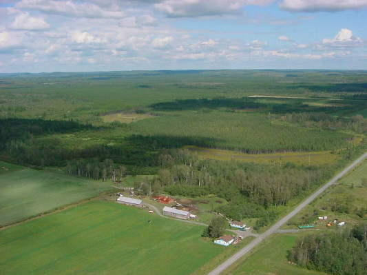
Figure 4.0 - Aerial view of the Ducks Unlimited Hilliardton Marsh Provincial Wildlife Area located in the townships of Hilliard and Ingram. The creation of this marsh began in 1993 with partners who included the Canadian Wildlife Service, The Nature Conservancy of Canada, Ontario Ministry of Natural Resources, Ducks Unlimited Canada, Ducks Unlimited, U.S. Fish and Wildlife Service and the State of Alabama. Photo courtesy of Ducks Unlimited Canada.
Natural Heritage Representative features
The following chart shows the different ecosite types and the forest stands associated with them.
| C1704 Hilliardton Marsh Conservation Reserve | Cedar, Black Spruce, Larch | Larch, Black Spruce, Cedar | Larch, Black Spruce, Poplar, White Spruce | Larch, Black Spruce | Balsam Poplar, Poplar, White Spruce, Balsam Fir | Jack Pine | Poplar | Poplar | Poplar, White Birch, Larch, Black Spruce, White Spruce | Poplar, Black Spruce, Larch | Poplar, Black Ash, Black Spruce | Poplar, White Spruce, Balsam Fir | Black Spruce | Black Spruce | Poplar, White Spruce | Black Spruce, Larch, White Spruce, White Birch, Jack Pine | Black Spruce, Jack Pine, White Spruce, Balsam Fir | Organic Deposits |
|---|---|---|---|---|---|---|---|---|---|---|---|---|---|---|---|---|---|---|
| Ecosite | 13r | 13r | 13p | 14 | 10 | 2 | 1 | 2 | 2 | 9r | 10 | 7f | 5f | 5f | 7c | 9p | 6m | 6f |
| Organic Deposits | * | 2 | 2 | 2 | 2 | 2 | 2 | 2 | 2 | 1 | 2 | 2 | 2 | |||||
| Alluvial Deposits – earlier post- glacial alluvium | 3 | |||||||||||||||||
| Alluvial Deposits – late post-glacial alluvium | 3 | 2 | 1 | |||||||||||||||
| Alluvial Deposits – delta plain | * | 1 | ||||||||||||||||
| Glaciolacustrine Deposits – silt and clay | * | 2 | 2 | 2 | 2 | |||||||||||||
| Glaciolacustrine Deposits – silty, fine sand | 3 | 2 | 2 | 1 | 2 | 2 | 2 | 1 | 2 | 2 | ||||||||
| Ice-Contact Stratified Drift Deposits | * | |||||||||||||||||
| Till Deposits | * | |||||||||||||||||
| Bedrock Outcrop – Precambrian | * | 1 | 2 |
Note: Landform: vegetation combinations have been grouped according to similar ecosite, landforms, age and species composition classification.
1Immature
2Mature
3Old Growth
Forest Resource Inventory (FRI) data:
- Dominant species, wetlands and depleted areas
- See Forest Stand Composition Map, Appendix 7, Map c
Values:
- Old growth forests
- Waterfowl breeding and staging area
- Deer habitat range
- Cold water fish species streams
5.1 Social/economic interest in area
a) Linkage to local communities:
The Hilliardton Marsh Conservation Reserve consists entirely of Crown land and is easily accessible via concession roads or Highway 569. Access to the site is also easily gained by the use of the numerous trails and cleared concession lines. Three separate patented land blocks in Pense and Brethour townships are encircled by the conservation reserve.
Current uses are related to consumption of fish and wildlife resources and snowmobiling. Potential recreational activities could include ATV riding and possibly non-consumptive uses such as bird watching or nature study. The present condition of the wetlands would make access into some of these areas difficult due to water levels and density of growth. In its present condition, the social and economic interest in this conservation reserve is not likely to be expanded beyond the current uses.
b) Heritage estate contributions:
The Hilliardton Marsh Conservation Reserve contributes to the province’s parks and protected areas system through its regulation, representation and the long-term management of its natural heritage values.
By allocating these lands to the parks and protected areas system, the province has ensured a certain level of permanence by distinguishing the site and its values from the broader general use or more extensively managed landscape. In addition, its natural features are, and will be, available for present and future generations to enjoy and explore.
DU's Hilliardton Marsh development is a supporting feature in the area. This marsh was established in 1993 by Ducks Unlimited to create and manage the marsh wetland complex in order to benefit waterfowl and other wetland dependent species. A portion of the conservation reserve was once a historical Area of Natural and Scientific Interest (ANSI), which included both Crown and private lands. A boundary was never established for this ANSI due to the complexity of the surrounding land tenure.
The overall condition of the site is relatively good with rather extensive wetlands in places. The dominant land use in the surrounding area is farming with hay and cereal crops being the primary products (Davis 1993). There are a lot of drainage ditches present within most parcels of the conservation reserve. However, the northern portion of the site contains intact forest communities within a very disturbed environment. The site does contribute some undisturbed forest stands and wetlands, which are valued within the heavily disturbed site district 4E-5 as heritage estate values. Also within this site district the conservation reserve provides representation of unique biophysiographic landscapes.
Long term management must consider public access to the site, the conservation reserve protection objectives, and commitments made in the OLL LUS (MNR 1999). Future managers will have to determine whether ecological restoration is required within the disturbed zones, or whether natural vegetation succession and long term monitoring of these disturbed areas is more appropriate.
c) Aboriginal groups:
The aboriginal communities in the Kirkland Lake District have not currently identified any traditional use areas or areas of interest within the site. However, should any aboriginal values be located within the site, they will be protected accordingly.
d) Mining interests:
There are no known current mining interests related to the conservation reserve. Mining and surface rights have been withdrawn from staking within the conservation reserve’s boundaries under the Mining Act (RSO 1990 Chapter M.14).
e) Forest and fire management history:
The site has not recently been affected by forest management activities. However a parcel of patented land which is surrounded by the new conservation reserve, in Brethour Township, was harvested in the winter of 2001-2002. Associated with this was the removal of a road right of way to the parcel of land to allow for the extraction of the timber.
The site has no recent burned areas within its boundary.
Figure 5.0 - This photo is of the area that was harvested in the winter of 2001-2002 in Brethour. The view is facing east and the boundary of the conservation reserve is the edge of the harvested area and the start of the poplar stand. Photo taken August 2002 by Craig Fuller.
5.2 Natural heritage stewardship
Landform information provided by the Ontario Forest Research Institute (1994) showed that the majority of the site consists of lacustrine deposits, however, aerial reconnaissance and photo interpretation by Kristjansson (2001) suggests a much different landform interpretation. The primary earth science feature is contained within the extensive areas of organic deposit. The site also contains pockets of alluvial deposits, mostly early and late post-glacial alluvium and glaciolacustrine deposits of silt, clay and fine sand. For more information on the earth science features see Hilliardton Marsh Earth Science Checksheet (Kristjansson 2002 (in prep.)).
The wetlands present within the site vary from shrub thicket to shoreline fen. A large conifer swamp is located on the western side of the Blanche River approximately mid-way through the site. Also, another conifer swamp is located above this one in the adjacent parcel to the north. Several other wetlands are interspersed throughout the conservation reserve.
When reviewing OFRI (1994) landform data it was noted that the majority of the site was classified as lacustrine deposit that does not correspond to the known earth science values within the conservation reserve. Refinement of the landforms based on the aerial reconnaissance survey and the surficial landform interpretation by Kristjansson (2001), resulted in this site being described as organic, alluvial and glaciolacustrine deposits. The site also contains bedrock outcrops in the southern and southeastern parcels of the site.
Aerial reconnaissance survey conducted in 2001 and the aerial photo interpretation provided by Kristjansson, showed the site to have six landform types with organic deposits dominating the site. Using Kristjansson’s interpretation, the best available FRI data and the notes completed in the field by Thompson (2001) resulted in the identification of a minimum of 61 landform: vegetation combinations.
No permanent MNR sampling plots are associated with the site.
5.3 Fisheries and wildlife
There have been no detailed wildlife studies within the Conservation Reserve. Some values assessments have been completed for the site and surrounding area. The Fish and Wildlife Values identified are waterfowl breeding and staging areas, deer habitat range and cold-water fish species streams. Fishing opportunities are limited due to the lack of watercourses and lakes. Graham’s Creek and Little Otterskin Creek, which run through portions of the site, have been stocked in the past with brook trout but no recent surveys have been performed to assess whether these populations are still present.
Some of the habitats associated with wildlife include wetlands and black spruce and aspen stands. All of these habitats, as well as the sections that have been harvested, provide year round habitat for moose as well as other species. The wetland areas provide excellent forage and breeding/nesting areas for waterfowl and attract many waterfowl hunters.
5.4 Cultural heritage stewardship
To date, a detailed assessment of cultural resources has not been carried out.
5.5 Land use/existing development
The conservation reserve is situated on Crown land and is unencumbered by any land use permits, leases or mining claims. Mining and surface rights have been withdrawn from the conservation reserve (MNDM G-Plan M-0282 December 12, 2001). There are no identified development or current structures located within the boundaries of the site. The Ontario Federation of Snowmobile Clubs presently uses certain trails throughout the reserve as part of its snowmobile trail system.
5.6 Commercial use
Present commercial use activities include three traplines (KL-74, KL-80 and KL-81), three bear management areas (BMAs KL-28-00, KL-28-27 and KL-28-38) and baitfish operations.
5.7 Tourism/recreation use/opportunities
Some of the features within this site associated with possible recreation use include wetland vegetation, aquatic flora and fauna, large and small land mammals and mixed forests. Existing recreational uses in this site and the immediate area surrounding the site include trapping, large game hunting, small game hunting and snowmobiling. There is also potential for activities such as ATV use, bird watching and nature study.
For a more detailed report and summary of the recreational use and potential refer to the Recreational Inventory Check-sheet. (Appendix #3)
5.8 Client services
Currently visitor services are limited to responding to inquiries about access, natural heritage features and boundaries. No formal information or interpretive facilities currently exist within the conservation reserve.
Other client services include providing clients with maps, fact sheets and other information gathered on the area, such as the Earth/Life Science and Recreational inventory work.
6.0 Management guidelines
6.1 Management planning strategies
The land use intent outlined in the OLL LUS (MNR, 1999) provides context and direction to land use, resource management, and operational planning activities on Crown land in the OLL planning area. Commitments identified in the above strategy along with current legislation (Policy 3.03.05 PLA) will form the basis for land use within the Hilliardton Marsh Conservation Reserve. Management strategies for this site must consider the short and long-term objectives for the reserve. For up to date information on permitted uses refer to the Crown Land Use Atlas.
New proposed uses and development on this site will be reviewed on a case-by-case basis. A Test of Compatibility, (Procedural Guideline B – Land Uses (PL 3.03.05) must be passed before new activities are deemed acceptable. The emphasis will be on ensuring that the natural values of the conservation reserve are not negatively affected by current and future activities. Therefore any application for new specific uses will be carefully studied and reviewed.
6.2 "State of the Resource" management strategies
The development of this SCI and the long term management and protection of the Hilliardton Marsh Conservation Reserve will be under the direction of the MNR's Kirkland Lake District, Kirkland Lake/Claybelt Area Supervisor. The following management strategies have been created to achieve the goal and objectives stated earlier in this management document.
Natural Heritage Stewardship
The management intent for the Hilliardton Marsh Conservation Reserve is to allow for natural ecosystems, processes and features to operate undisturbed with minimal human interference while providing educational, research and recreational opportunities. Forest ecosystem renewal will only be entertained in a separate vegetation management plan. As part of any future vegetation management plan, the Conservation Reserve and the Site District will be re-evaluated with respect to known landform/vegetation features to determine if the harvested areas could contribute additional landform/vegetative values to the Site District. In addition, the vegetation management plan will need to determine but not be limited to:
- the restoration ecology objectives (e.g. representation) for the area in context with the Site District
- consider current provincial strategies (e.g. white pine)
- consider larger long-term conservation reserve (e.g. recreational objectives) and possibly landscape objectives (e.g. contributions to landscape wildlife objectives)
Forest fire protection will be carried out as on surrounding public lands, under the direction of the provincial fire strategy. All wildfire occurrences will be considered a high priority and will actively be suppressed. Prescribed burning will be conducted only under suitable conditions and the direction of the provincial fire strategy and authorized for the conservation reserve under a separate vegetation management plan. Prescribed burning may be utilized if deemed necessary to emulate natural disturbances and renew forest communities, prepare seed beds for research and/or education purposes or to meet additional objectives determined within a separate vegetation management plan.
Defining compatible uses, enforcing regulations and monitoring and mitigating issues will protect all earth and life science features. Industrial activities such as; commercial timber harvest and new hydro generation will not be permitted within the conservation reserve. Permits for fuel-wood will not be issued. Energy transmission, communication and transportation corridors or construction of facilities are not permitted within the boundaries of the conservation reserve. Such structures negatively impact on the quality of the representative features that require protection. Alternatives should be reviewed via larger landscape planning processes. New roads for resource extraction will not be permitted. Other activities that do not pass a Test of Compatibility will be prohibited (MNR Policy 3.03.05, 1997).
The introduction of exotic and/or invasive species will not be permitted. Programs may be developed to control forest insects and diseases where there is a concern that significant values may be compromised. Remedies must focus on the outbreak or infestation. Biological or non-intrusive solutions should be applied whenever possible. The collection/removal of vegetation and parts thereof will not be permitted; however, subject to a Test of Compatibility, the Area Supervisor may authorize such activities for purposes of rehabilitating degraded sites within the reserve, collecting seeds for maintaining genetic stock and/or for inventory or research purposes.
MNR will provide leadership and direction for maintaining the integrity of this site as a heritage estate. To ensure MNR protection objectives are fully met within the conservation reserve, activities on the surrounding landscape, such as agricultural operations and tile drainage should consider the site’s objectives and heritage values. Research, education and interpretation will be encouraged to provide a better understanding of the management and protection of the natural heritage values and will be fostered through local and regional natural heritage programs, initiatives and partnerships.
The conservation reserve will be managed by allowing natural ecosystems, processes, and features to function with minimal human interference.
Programs may be developed to control forest insects and diseases in the conservation reserve where these threaten significant heritage, aesthetic, or economic values. Where control is desirable, it will be directed as narrowly as possible to the specific insect or disease. Biological control will be used wherever possible.
Fisheries and wildlife
Fishery and wildlife resources will continue to be managed in accordance with specific policies and regulations defined by the Ontario Ministry of Natural Resources under the Fish and Wildlife Conservation Act and the Kirkland Lake District, Kirkland Lake/Claybelt Area Supervisor.
Fishing and hunting will likely continue at a low level of intensity. Wildlife viewing activities may be enhanced by a planned trail and viewing area development. Any future trail development will require a test of compatibility.
Cultural heritage
When possible, the Ministry of Natural Resources will continue to work with the Ontario Ministry of Culture, Tourism and Recreation in identifying archaeological sites to be protected. To more fully manage and protect sites, the development of field surveys would be required. However at this time additional field surveys are not recommended.
Development, research and education proposals may be considered in accordance with the Test of Compatibility; Conserving a Future for our Past: Archaeology, Land Use Planning & Development in Ontario, Section 3 (MCzCR, 1997).
Social/economic
Forest fire protection will be carried out as on surrounding public lands, until alternative direction for the control of fire, or the use of fire for management purposes, is approved through a more detailed local natural resource plan or management plan.
Land use and development
The sale of lands within the conservation reserve is not permitted as per the OLL LUS (MNR, 1999). Existing authorized trails can continue unless there are significant demonstrated conflicts. New trails will only be allowed if a Test of Compatibility is passed. The cutting of trees for non-commercial purposes (e.g. fuelwood) is not permitted except to carry out approved development activity (e.g. trail, viewing site, etc.).
New roads for resource extraction will not be permitted. Abandoned forest extraction roads will not be actively maintained.
Commercial use
All existing commercial bait fishing and commercial bear hunting (within BMAs) operations are permitted to continue. Existing commercial bear hunting operations, for non-residents, are permitted and the transfer of existing licenses is allowed. No new commercial bear hunting operations will be permitted.
Existing commercial fur harvesting operations are permitted to continue. New operations may be considered subject to a Test of Compatibility. No new trap cabins will be permitted.
Aboriginal interests
Aboriginal and treaty rights will continue to be respected.
Tourism/recreation
The identification and protection of the site’s earth and life science features and their protection, shall be the overall theme for tourism. Small-scale infrastructures for enhancing tourism and recreation (i.e., warm-up shelter) may be considered, providing they pass a Test of Compatibility and other MNR requirements.
Most recreational activities that have traditionally been enjoyed in this area can continue provided they pose little or no threat to the natural ecosystems and features protected by the Hilliardton Marsh Conservation Reserve. Permitted activities include walking, hiking, wildlife viewing, fishing, hunting, snow shoeing, and cross-country skiing.
Snowmobiles and All-Terrain Vehicles (ATVs) are permitted on existing trails and forest access roads within the Conservation Reserve. Under the OLL LUS (MNR, 1999), all mechanized travel is restricted to existing trails. Off trail vehicle use is permitted for the retrieval of game only.
Existing trails for hiking, snowmobiling, ATV use, cycling, horseback riding and cross-country skiing can continue. To ensure the quality of the representation is maintained, all trails and old forest access roads within the site should be identified via new technologies (i.e. GPS) to ensure a record of these features exist. New trails can be considered through a Test of Compatibility.
Finally, conflict resolution between recreational uses will be a priority. This will be achieved by adhering to the objectives of this SCI with input from relevant user groups. The level of safety and compatibility between activities will determine permitted uses (i.e., Test of Compatibility).
Client services
Clients indicating their interest in the management, planning and future use of the conservation reserve will be put on a mailing list and notified of any future planning in the site.
Present client services, such as supplying maps, fact sheets and other information, will also continue. Information may be delivered from different sources, however, MNR will be the lead agency for responding to inquiries regarding access, permitted and restricted activities, values and recreation opportunities. A management agreement may be pursued with an appropriate partner to share responsibilities for information services and the delivery of other aspects of this SCI in the future.
6.3 Specific feature/area/zone management strategies
There are no specific management strategies for the maintenance/protection/enhancement of selected resources within the conservation reserve. Development of such strategies will require an amendment to the SCI.
6.4 Promote Inventory, Monitoring and Assessment Reporting (IMAR), and research
Scientific research by qualified individuals, which contributes to the knowledge of natural and cultural history and to environmental and recreational management, will be encouraged.
Additional life science inventory or research is indicated at this time in order to refine values and features. Additional assessment and monitoring of the disturbed areas, including trail and old road locations, within the site should occur prior to any additional management direction being developed via a vegetation management plan for the area.
Research related to the study of natural processes will be encouraged provided it does not harm the values of the reserve. The Kirkland Lake/Claybelt Area Supervisor may approve the removal of any natural or cultural specimen by qualified researchers. All such materials removed remain the property of the Ministry of Natural Resources. All research programs will require the approval of the Ministry of Natural Resources and will be subject to Ministry policy and other legislation.
New research developments such as campsites, privies, trails or developed access points or activities will not be considered until a Test of Compatibility is conducted and proposal is approved by the Kirkland Lake/Claybelt Area Supervisor. The Test of Compatibility or environmental screening process could include a review of the demand for structures or activities and may require more detailed life or earth science or cultural information and possibly a more detailed management plan.
Approved research activities and facilities will be compatible with the protection objective. Permanent plots or observation stations may be established to which researchers can return over time. Any site that is disturbed will be rehabilitated as closely as possible to its original state.
6.5 Implementation, and plan review strategies
The Hilliardton Marsh Conservation Reserve Statement of Conservation Interest will be reviewed on an ongoing basis and as required.
Implementation of the SCI and management of the reserve are the responsibility of the Area Supervisor. Partnerships may be pursued to address management needs.
If changes in management direction are needed at any time, the significance of the changes will be evaluated. Minor changes that do not alter the overall protection objectives may be considered and approved by the District Manager without further public consultation and the plan will be amended accordingly. In assessing major changes, the need for a more detailed Resource Management Plan will first be considered. Where a Resource Management Plan is not considered necessary or feasible, a major amendment to this SCI may be considered with public consultation. The Regional Director will approve major amendments.
6.6 Marketing strategies
The Hilliardton Marsh Conservation Reserve will be marketed as a representative natural area having earth and life science values, as well as certain recreational values. Marketing efforts to increase use are not a priority and will be kept to a minimum.
6.7 Boundary identification
There is no stated policy requirement to mark the boundaries of a Conservation Reserve. Local management discretion can be used to determine where boundary marking may be appropriate. In order for restrictions to be enforceable, signs must be placed in accordance with the Trespass to Property Act or subsection 28 (1) of the Public Lands Act to advise of any restricted recreational activities.
Figure 6.0 - Photo is looking northwest over a portion of the site. The farm located at the bottom of the photo, and the associated fields, is one of many bordering the Hilliardton Marsh Conservation Reserve. As well another border to the site is evident with the road running north south. These features provide for an easy recognition for parts of the site boundaries. Photo taken August 18, 2001 by Craig Fuller.
7.0 References
1983. Ontario Ministry of Natural Resources. Kirkland Lake District Land Use Guidelines.
1990. Trespass to Property Act. Government of Ontario. Queen’s Printer. Toronto.
1992. Mining Act. Government of Ontario. Queen’s Printer. Toronto.
1993. Public Lands Act. Government of Ontario. Queen’s Printer. Toronto.
1997. Fish and Wildlife Conservation Act. Government of Ontario. Queen’s Printer. Toronto.
1997. Conservation Reserve Policy and Procedure PL 3.03.05. Ontario Ministry of Natural Resources. 30pp.
Ontario Ministry of Natural Resources, Ontario Living Legacy Land Use Strategy, July 1999
Saturday, 21st April, 2001. The Ontario Gazette, Volume 134-16. Queen’s Printer. Toronto
Bostock, H. S. Physiographic Subdivisions of Canada. Geology and Economic Minerals of Canada.
Harris, A. G., et. al. Field Guide to the Wetland Ecosystem Classification for Northwestern Ontario. Natural Resources Canada. May 1996.
Rowe, J. S. Forest Regions of Canada. Department of Fisheries and the Environment Canadian Forestry Service. 1972.
1993. Project Plan of the Hilliardton Marsh – Waterfowl Improvement Project. Peter Davis, MNR
2001. J.E. Thompson. Aerial Reconnaissance Notes, MNR
Kristjansson, R. 2002. Earth Science Checksheet, in prep. and aerial landform/surficial material interpretation.
Melanie Silver. 2002. Natural Heritage Area – Life Science Checksheet, MNR