Hockley Valley Provincial Park Management Plan
This document provides policy direction for the protection, development and management of Hockley Valley Provincial Park and its resources.
© 2005, Queen’s Printer for Ontario
Additional copies of this publication are obtainable from:
Earl Rowe Provincial Park
P.O. Box 872
Alliston, Ontario L9R 1W1
Telephone: 705-435-2498
51203-1
(0.45k P.R. 05 01 17)
ISBN 0-7778-8488-7
Approval statement
I am pleased to approve the Hockley Valley Park Management Plan as the official policy for the protection and management of this nature reserve. The plan reflects the Ministry of Natural Resources' and Ontario Parks' commitment to manage Hockley Valley for the people of Ontario as a nature reserve class provincial park, protected from the impacts of human activity, now and in the future.
The plan outlines a prioritized implementation strategy and summarizes the public consultation that occurred as part of the planning process.
The plan for Hockley Valley Provincial Nature Reserve will be used to guide the management of the park. It may be reviewed to address changing issues or conditions.
I wish to extend my sincere thanks to all those who participated in the public consultation process.
Yours truly,
Signed by:
Adair Ireland-Smith
Managing Director
Ontario Parks
Date: November 30, 2004
Statement of Environmental Values and the Environmental Bill of Rights
In 1994, the Ministry of Natural Resources (OMNR) finalized its Statement of Environmental Values (SEV) under the Environmental Bill of Rights (EBR). The SEV is a document that describes how the purposes of the EBR are to be considered whenever decisions are made in the ministry that might significantly affect the environment. This includes decisions made as a result of a park management planning process.
The primary purpose of the EBR is "to protect, conserve and, where reasonable, restore the integrity of the environment." From the ministry’s perspective, that broad statement of purpose translates into four objectives in its SEV:
- to ensure the long-term health of ecosystems by protecting and conserving our valuable soil, aquatic resources, forest and wildlife resources as well as their biological foundations
- to ensure the continuing availability of natural resources for the long-term benefit of the people of Ontario
- to protect natural heritage and biological features of provincial significance and
- to protect human life, the resource base and physical property from the threats of forest fires, floods and erosion
During the development of the Hockley Valley Park Management Plan, the ministry considered its SEV. The management plan will further the objectives of managing Ontario’s resources on an environmentally sustainable basis.
1.0 Introduction
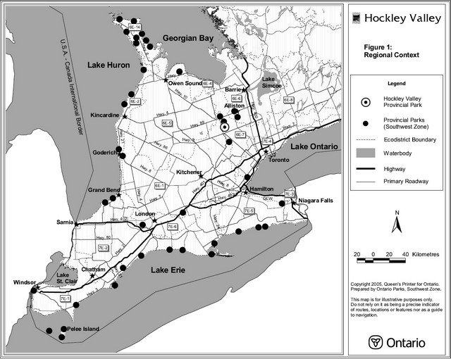
Hockley Valley Provincial Nature Reserve is located within the rolling moraine landscapes of the Niagara Escarpment. Through the centre of the nature reserve can be found a scenic deep-cut tributary valley to the Nottawasaga River. In this valley a wide variety of locally unique vegetation communities, vascular plant species and wildlife can be found.
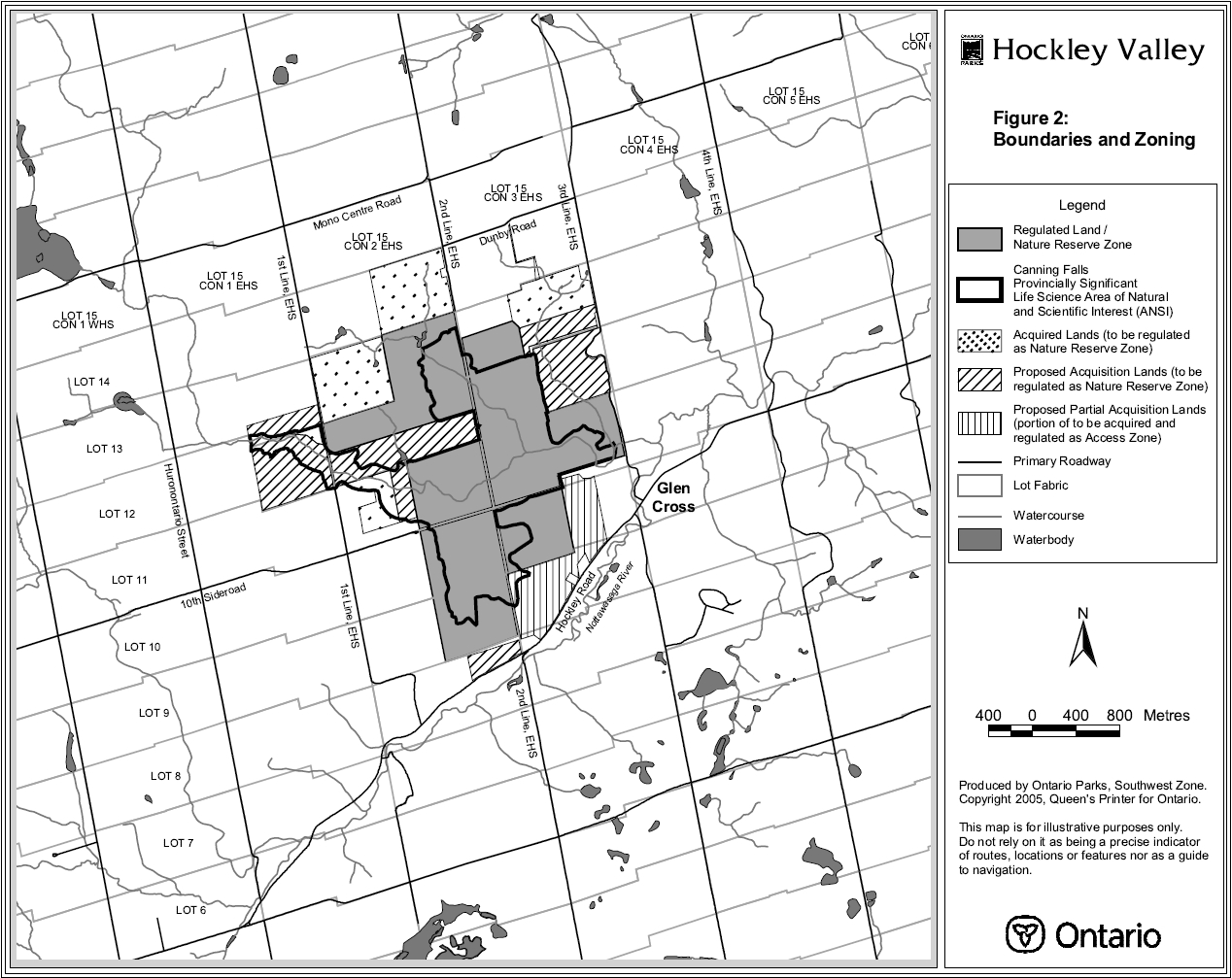
The 378 hectare nature reserve is located approximately five kilometres north east of Orangeville, in the Town of Mono, County of Dufferin (see Figure 1). The nature reserve is situated north of Hockley Road (Dufferin County Road 7), west of the 3rd Line, East of Hurontario Street (E.H.S.), and east of the 1st Line, E.H.S., (see Figure 2). In the summer this scenic area offers local residents and tourist’s opportunities for hiking along the Bruce Trail. During the winter, cross-country skiing and snowshoeing are popular activities.
Access into the nature reserve is not formally monitored and to date no attempt has been made to systematically determine the total number of visitors in the park. It is estimated that approximately 10,000 visitors use the nature reserve on an annual basis. Visitation peaks in autumn during fall colours.
Agriculture has been an important cultural component in the Hockley Valley. While there remains good active farm land in the area, the more rugged lands and steep slopes adjacent to the valley, if cleared at all, suffered from erosion and in more recent years, proved unsuitable for mechanized farming methods. While some of the land has been retained as pasture land, other land has reverted to forest cover.
Several sawmills and a grist mill were located in the vicinity. Other past activities in the area included quarries and lime burning. Aboriginal walking trails were located along the Nottawasaga River. The Toronto/Syndenham Road (1840-1850) was located in this area, stretching from Mono Mills to Glen Cross to Mono Centre and pushing further north. South of the park, exists a natural spring that was used for drinking water by travelers and their horses. Hockley Valley has always been a popular day trip location with Toronto papers advertising the area since the late 1920s and 1930s. Today, the area is seeing greater numbers of tourists as more people discover the local beauty.
In 1990, the bureau of the United Nations Educational, Scientific and Cultural Organization (UNESCO) Man and Biosphere (MAB) program approved the designation of the Niagara Escarpment as a World Biosphere Reserve. The designation recognizes the natural features and ecological importance of the Escarpment, of which Hockley Valley Provincial Nature Reserve is an integral element.
Figure 1 - Hockley Valley Regional Context
Enlarge Figure 1 - Hockley Valley Regional Context map
Figure 2 - Hockley Valley Boundaries and Zoning

Enlarge Figure 2 - Hockley Valley Boundaries and Zoning map
Hockley Valley Provincial Nature Reserve is part of the Niagara Escarpment Parks and Open Space System (NEPOSS) which protects the significant natural and cultural features along the escarpment, and provides for recreation and appreciation of the features. The NEPOSS presently consists of well over 100 parks and open spaces owned and managed by a variety of agencies. The Bruce Trail is an essential component of the NEPOSS linking parks, open space areas and natural features.
NEPOSS sites within a 25-kilometre radius of the nature reserve include Pine River Fishing Area, Mulmur Hills, Boyne Valley Provincial Park, Mono Cliffs Provincial Park, Humber Valley, Mono Mills Lowlands, Glen Haffy Conservation Area, Ken Williams Resource Management Area, Forks of the Credit Provincial Park, Willoughby Property, and Belfountain Conservation Area. The nature reserve is located within the watershed managed by the Nottawasaga Valley Conservation Authority.
Hockley Valley Provincial Nature Reserve was regulated in May 1989 under Ontario Regulation 290/89, Schedule 247, made under the Provincial Parks Act. Adjacent land uses include agriculture, rural residential, recreational and commercial. Ontario Parks' staff operating out of Earl Rowe Provincial Park, near Alliston, manage Hockley Valley Provincial Nature Reserve.
For the purposes of Part 3.1.6 of the Niagara Escarpment Plan, the Ministry of Natural Resources and the Niagara Escarpment Commission have determined that this management plan for Hockley Valley Provincial Nature Reserve is not in conflict with the Niagara Escarpment Plan.
2.0 Classification
Under both Ontario Parks' policy and the Niagara Escarpment Plan, Hockley Valley is classified as a nature reserve class provincial park because it represents one of the most significant and distinctive natural areas and landforms found along the Niagara Escarpment. This site provides the best representation in the Dufferin section of incised gorge, ice-contact deposits, waterfalls and stream features. This site also supports excellent and highly representative examples of mesic (intermediate moisture) mixed forests, open water river, wet cliffs (spray zone), mixed and conifer rim forests, wet-mesic mixed forests and mixed swamps. The area provides habitat for a number of rare plant and animal species.
Nature reserve class parks, under Ontario Parks' policy, are areas selected to represent the distinctive natural habitats and landforms of the province. They are protected for educational purposes, as gene pools, for research to benefit present and future generations, and for their intrinsic value to society.
Nature reserve class parks, under the NEPOSS policy, are areas that represent the most significant and distinctive natural areas and landforms found along the Niagara Escarpment. These areas serve to protect selected Areas of Natural and Scientific Interest. Management practices and uses in a nature reserve will ensure that the features and values for which the reserve was established remain protected in perpetuity.
3.0 Goal
To protect the provincially significant natural heritage of the nature reserve and to provide low environmental impact recreational, educational, and research opportunities to benefit present and future generations.
Hockley Valley will be managed for the people of Ontario as a nature reserve class provincial park, protected from the impacts of human activity, now and in the future. The park is governed by the Provincial Parks Act, Niagara Escarpment Planning and Development Act, Niagara Escarpment Plan, Ontario Provincial Parks Policy and Ontario Provincial Parks: Planning and Management Policies.
4.0 Objectives
There are four established objectives for the Ontario Parks' system: protection, recreation, heritage appreciation and tourism. Hockley Valley Provincial Nature Reserve contributes towards each of the Ontario Parks' system objectives but primarily protection and heritage appreciation.
4.1 Protection
To protect provincially significant elements of the natural and cultural landscape of Ontario.
The protection objective of Hockley Valley Provincial Nature Reserve will be accomplished through appropriate park zoning, land use controls, research, monitoring and an ecosystem approach to park planning and management.
The greater park ecosystem can be defined as the area of influence surrounding the nature reserve from an ecological, social, and economical point of view. It is also the area where most of the impacts affecting the nature reserve occur.
Hockley Valley has its own, unique park ecosystem. A number of variables including vegetation, watershed, geology, habitat, recreation, tourism, and development can be used to define the park ecosystem. The ecosystem management approach is a co-operative and participatory one. It does not imply provincial control in local affairs or place any restrictions on private property rights.
4.1.1 Life science
Hockley Valley Provincial Nature Reserve is located within Ecodistrict 6-7 (see Figure 1) and comprises approximately 80 percent of the provincially significant Cannings Falls Life Science Area of Natural and Scientific Interest (ANSI) (see Figure 2). Within the most recent life science inventory of the ANSI (Brownell 1980) there were 33 vegetation communities collectively supporting 417 vascular plant species. Two regionally rare species that occur are the Cuckoo-flower and the Hooked Violet. The nationally endangered Butternut has also been recorded on site. There have been records of the nationally vulnerable Louisiana Waterthrush breeding in the area. Evidence of the locally rare Northern Long-eared Bat and two amphibian species, the Jefferson Salamander (Bogart et al. 1993) and the Jefferson Salamander complex hybrid, have also been found. The Jefferson salamander is designated as nationally threatened by the Committee on the Status of Endangered Wildlife in Canada (COSEWIC). The Northern Brook Lamprey, a species of special concern according to COSEWIC and the Committee on the Status of Species-at-Risk in Ontario (COSSARO), has also been documented.
4.1.2 Earth Science
Hockley Valley Provincial Nature Reserve contains a tributary valley leading to the Nottawasaga River. The valley runs in an east-west direction. Moraine topography with rolling hills occurs in the north end of the nature reserve. This is part of the Orangeville moraine. Within the valley, mixed swamps and lowland forests occur where gravel and sand deposits can be found from glaciofluvial deposits. Recent deposits of silt, sand and gravel can be found along the Queenston Shale formations of the valley. These features combined impart highly aesthetic and educational values to the nature reserve and form part of the provincially significant Cannings Falls Earth Science ANSI.
4.2 Heritage appreciation
To provide opportunities for exploration and appreciation of the outdoor natural and cultural heritage of Ontario.
Exploration and appreciation of the natural and cultural heritage will be emphasized in a manner that is non-destructive or intrusive to the nature reserve’s features and landforms. It will be in an unstructured format for visitors. Interpretive signs may be installed at strategic locations throughout the nature reserve. These may include main entrance points and trail junctions. The interpretive signs will outline information on significant features in the nature reserve.
4.3 Niagara Escarpment Parks and open space system
The Niagara Escarpment Plan (NEP), in part, sets out policies for parks and open space areas along the Niagara Escarpment. Lands within NEPOSS are to be planned, managed and developed in a manner compatible with the NEP. The Hockley Valley Park Management Plan strives to incorporate and meet the distinct objectives of the NEPOSS as outlined in the NEP. These objectives are:
- to protect unique ecological and historical areas
- to provide adequate opportunities for outdoor education and recreation
- to provide for adequate public access to the Niagara Escarpment
- to complete a public system of major parks and open spaces through additional land acquisition and park and open space planning
- to secure a route for the Bruce Trail
- to maintain and enhance the natural environment of the Niagara Escarpment
- to support tourism by providing opportunities on public land for discovery and enjoyment by Ontario’s residents and visitors and
- to provide a common understanding and appreciation of the Niagara Escarpment
This park management plan must conform with the Niagara Escarpment Plan.
5.0 Boundary
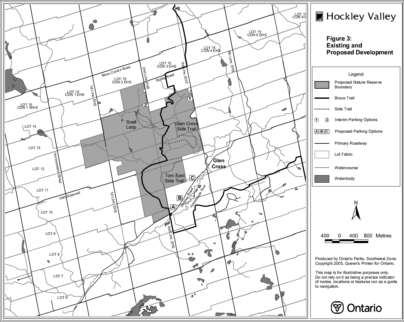
Hockley Valley Provincial Nature Reserve was regulated under Ontario Regulation 290/89, Schedule 247, made under the Provincial Parks Act. All provincially owned properties within the proposed boundary will be regulated as part of the nature reserve. The nature reserve’s existing and proposed boundaries are shown in Figure 2. The Bruce Trail corridor from the northern park boundary to Dunby Road may be regulated to control park access (see Figure 3). The nature reserve boundary will be signed where it borders traveled roads and at trail entrances.
Subject to availability of resources, adjacent life science and earth science ANSI designated lands will be considered for acquisition and regulation. Land acquisition will also be considered for both unregulated intervening and adjacent unopened road allowances, to consolidate park holdings. A high priority will be given to the acquisition of a suitable parcel to provide a safe and accessible parking area along Hockley Road.
6.0 Zoning
Hockley Valley Provincial Nature Reserve will be zoned based on the Ontario Provincial Parks: Planning and Management Policies. Zones differentiate the permissible degree of development, recreational uses and management practices. These zones are in basic conformity with NEPOSS zoning policies contained in the Niagara Escarpment Plan.
Under the Niagara Escarpment Plan, lands within the Hockley Valley Provincial Nature Reserve proposed boundary have three separate land use designations. These include natural area, which is the primary designation, and smaller sections of both protection area and rural area.
6.1 Nature Reserve zone
The nature reserve zone will comprise the entire 378 hectares of the currently regulated nature reserve. This zoning will ensure the protection and continued existence of the significant features and landforms found within the nature reserve. This zone will provide low environmental impact recreational activities, which include hiking and nature appreciation along designated trails. In addition to trails, development will be limited to necessary signs and temporary facilities for management. Future additions to the park will also be zoned as nature reserve, with the exception of a future parking area and trailhead.
6.2 Access zone
An access zone in the nature reserve may be developed in association with a proposed parking area and trailhead adjacent to Hockley Road in the vicinity of the south Bruce Trail entrance. The access zone will be approximately one to two hectares in size. Development will be limited to a parking area and orientation, interpretive, educational, and management facilities.
If regulated as part of the nature reserve, the Bruce Trail corridor from the present park boundary north to Dunby Road would be zoned as nature reserve.
Figure 3 - Existing and proposed development.

Enlarge Figure 3 - Hockley Valley Existing and Proposed Development map
7.0 Natural heritage stewardship policies
Hockley Valley Provincial Nature Reserve will be managed in accordance with the policies set out in the Ontario Provincial Parks: Planning and Management Policies. Natural heritage stewardship initiatives may be accomplished through partnerships and sponsorships.
All management prescriptions for the nature reserve will comply with the Endangered Species Act, which protects all provincially designated endangered species and their habitats from any negative interference.
7.1 Land and water management
Stream and water improvement projects may occur where deemed necessary through biophysical assessment of the nature reserve. This would include areas along the river which runs through the nature reserve at the base of the main valley, the tributary stream which flows from the north end of the nature reserve and the pond located near the Snell Loop.
It may be necessary to build boardwalk structures, water bars and other infrastructure along the Bruce Trail and side trails where continued erosion and seasonal wetland conditions occur. This is necessary to avoid continued erosion to trails and to improve the nature reserve visitors' experience.
Signs, fencing, barriers and/or gates may be installed in areas where unauthorized vehicular access occurs. Unsanctioned side trails will be closed off and allowed to regenerate naturally or through appropriate restoration techniques.
Several parcels within the nature reserve are rented out for private agricultural use. Agricultural uses are an existing, non-conforming activity that will be discontinued as of January 1, In the interim, no new agricultural land use permits will be issued and existing permits will be non-transferable.
7.2 Integrated ecosystem management
Except where there is threat to public safety, dead trees will be left standing to serve as important homes for resident cavity nesting birds and mammals. Dead tree falls and tip-ups will also be left in place to serve as important sites for mosses and fungi, germination areas for tree species requiring rotting wood as a rooting medium, and moist shelters for small mammals, reptiles, amphibians and a variety of insects.
The occurrence of insects and diseases native to the forest region in which the nature reserve is situated is recognized as an integral component of the ecology of the nature reserve. Insect infestations and diseases will normally be allowed to progress naturally. If such outbreaks threaten values for which the nature reserve was established to protect, they may be controlled where feasible, using biological controls whenever possible.
Insects and diseases not native to the nature reserves' forest region will be controlled where feasible. When control is undertaken, it will be directed as narrowly as possible to the specific insect or disease, so as to have minimal effects on the balance of the nature reserve’s environment. Biological controls will be used whenever possible.
Non-native species will not be deliberately introduced into the nature reserve. Existing non-native species may be removed where they threaten the continued existence of native species. Examples of introduced species include Scot’s Pine and Purple Loosestrife.
Reintroduction of native species may occur if it does not threaten current natural park features. Reintroduction must be ecologically sound and acceptable.
Rare and significant species will be monitored to ensure their continued existence within the nature reserve. Protection and recovery plans may be developed and implemented as necessary for the perpetuation of such species.
Sport fishing will be permitted. Commercial bait fishing will not be permitted. Fish habitat management projects may occur to improve the habitat for cold water fish species that use the river as a spawning ground.
Sport hunting and commercial trapping will not be permitted. However, control of particular wildlife species may be required for public safety, protection of property, and perpetuation of natural values.
Lands taken out of agricultural production may be planted in an appropriate cover crop as a means of controlling weeds. Open fields may be permitted to regenerate naturally and/or may be restored using appropriate vegetation management prescriptions.
Ecological management will be directed to the maintenance of an evolving natural ecosystem. A resource stewardship plan may be prepared for the nature reserve in which adaptive management strategies will be addressed.
7.3 Scenic resources management
As outlined in the Hockley Valley Viewshed Analysis, the area is considered to be of high aesthetic and scenic value. Viewsheds of the area are significant from the moraine heights throughout the nature reserve, primarily on the north side. These values will be protected through non-intrusive management policies that will perpetuate the natural features of the nature reserve. Trails will be monitored and maintained in order to prevent damage to the area.
8.0 Operations policies
Operations policies for Hockley Valley will be incorporated into the operations plan for Earl Rowe Provincial Park. The revised plan will provide park staff with the necessary direction to effectively manage the park. In addition to addressing the operations policies that follow, the plan will include such topics as budget, staffing, maintenance schedules, enforcement, and emergency services. The provisions of the plan will be consistent with the approved Ontario Provincial Parks Minimum Operating Standards and will be reviewed annually and updated as required.
8.1 Natural Heritage Education
The Natural Heritage Education program of the area will be conducted in a self-use manner. The three components of natural heritage education are: information, interpretation and outdoor recreation. Interpretive signs will be provided, subject to the availability of funding, at strategic locations throughout the nature reserve in order to meet the interpretation and information components. The signs will discuss significant park features with a focus on their protection. Topics may include: earth science features with a focus on the Niagara Escarpment; life science features such as significant flora and fauna of the area; river valley ecosystems; wetland ecosystems; hardwood forest ecosystems including climax forests and successional changes; and the Niagara Escarpment as a World Biosphere Reserve.
The outdoor recreation component will be met through the provision of low impact activities on designated trails such as nature appreciation and hiking.
8.2 Research
Appropriate research will be encouraged. All research activities will conform to the Ontario Parks Research and Information Strategy and Ontario Parks' policies, and must meet all requirements under applicable provincial and federal legislation. Prior written permission will be required. All research will be non-intrusive in order to safeguard protection objectives. Research priorities for the nature reserve include a trail impact study on significant park vegetation and the development of an ecological monitoring program.
Within the Hockley Valley Provincial Nature Reserve, a one-hectare permanent forestry biodiversity plot was established in 1997 by the Niagara Escarpment Commission, in partnership with the University of Waterloo and the Ministry of the Environment. The purpose of the plot is for long-term monitoring of changes in forest biodiversity and forest health in areas of the Escarpment where human disturbance is minimal. To monitor forest biodiversity (conducted every five years), trees are tagged and identified to the species level. Tree diameter-at-breast height and status (alive/dead) is also recorded. Ground cover (1m x 1m) and shrub/sapling (5m x 5m) biodiversity plots are also established and monitored. The Ecological Monitoring and Assessment Network of Environment Canada acts as a central repository for data collected in other plots across Canada. A tree health assessment (i.e., an examination of crown mortality and stem defects) is conducted annually within the Hockley Valley plot. These data are submitted to the Canadian Forest Service for incorporation into a national database for examining forest health trends.
8.3 Recreational management
Only those recreational activities that have minimal, or mitigable impacts on life science and earth science features, will be considered in the nature reserve. Throughout the planning process, many comments were received endorsing low impact activities within Hockley Valley such as hiking and nature appreciation. This was further supported by a visitor survey, which strongly identified hiking and nature appreciation activities as the preferred uses of the nature reserve. Ninety-one percent of all people surveyed agreed with the classification of nature reserve for Hockley Valley Provincial Park.
Recreational activities that occur within the nature reserve will have low environmental impacts and will focus on nature appreciation of the area. Permitted activities include hiking, nature appreciation, sport fishing, snowshoeing and cross country skiing.
Prohibited recreational activities include camping, mountain biking, sport hunting, snowmobiling and all-terrain or off-road vehicle use. Horseback riding is an existing, nonconforming activity, on authorized trails, that will be permitted until January 1, 2010, in consideration of local riders. Horse trailer parking will not be permitted in the nature reserve.
9.0 Development policies
9.1 Access
Hiking access into the nature reserve will be permitted at the north and south entrances and at the proposed interim parking area. Unauthorized access points will be closed.
At present, roadside parking along Hockley Road, near the south entrance of the Bruce Trail, creates a potentially hazardous situation for both pedestrians and motorists. Ontario Parks closely examined opportunities to develop a vehicle parking area and trailhead during the park management planning process, however, the issue remains unresolved at this time. Comments received during the public consultation process did not support any of the proposed parking area sites adjacent to Dunby Road, or the 1st Line, 2nd Line or 3rd Line, E.H.S.
In 1999, a three-way land exchange proposal was recommended by the Town of Mono as a means of securing a suitable parcel for a parking lot. The proposal would have entailed the acquisition of privately owned land (listed for sale at the time) by a private party, who would subsequently exchange the land for surplus local property owned by the province. The proposal had to be abandoned as the former OntarioNiagara Escarpment land acquisition program did not allow for the disposition of previously acquired provincial lands (including via land exchanges). Furthermore, public consultation supported the regulation of all acquired provincial lands as additions to the nature reserve.
Ontario Parks will continue its efforts to acquire a suitable parcel of land along Hockley Road for a permanent parking lot and trailhead (see Figure 3 'Proposed Parking Options'). Ontario Parks is prepared to provide an interim parking facility either on the 3rd Line, E.H.S., south of Dunby Road, or at the end of the 2nd Line, E.H.S., south of Dunby Road (see Figure 3 'Interim Parking Options'), provided the Niagara Escarpment Commission and the Town of Mono support one of these options and approves the associated entrance. In cooperation with willing partners, Ontario Parks will also explore alternative parking opportunities outside the existing nature reserve.
Motorists will be directed to the (interim or permanent) parking area through appropriate directional signage at trail entrances.
9.2 Trails
Hockley Valley is a trail-oriented nature reserve. The permitted uses along the trails are nature appreciation and hiking. During the winter season, skiing and snowshoeing are permitted. Trails will be posted accordingly at points of authorized entry.
There are approximately five kilometres of the main Bruce Trail corridor passing through the nature reserve and an additional 6.5 kilometres of side trails (see Figure 3). The Caledon Hills Club, a member of the Bruce Trail Association, cooperatively maintains the trails. There are erosion problems on slope areas along the side trails (i.e., Tom East Side Trail, Glen Cross Side Trail and Snell Loop). Rehabilitation of these sites will occur with proper trail engineering and continued monitoring.
Park staff will ensure that all unsanctioned side trails and entrances will be closed. Active monitoring by park staff will ensure non-conforming uses will not occur. A trail stewardship plan may be developed to further outline the operation policies of all trails within the nature reserve.
If additional lands are acquired along the Bruce Trail optimum route, existing trails may be re-routed, or new trails constructed, to reflect this route. Any trail rerouting or development would be outlined in a trail stewardship plan. Development of a trail stewardship plan will involve the Bruce Trail Association, the Caledon Hills Club and other stakeholders.
9.3 Interpretive facilities
Interpretive signs may be provided at strategic locations throughout the nature reserve. These locations include, but are not restricted to, main entrance points and trail junctures.
9.4 Research facilities
No permanent research facilities will be developed within the nature reserve. The permanent forestry biodiversity monitoring plot described in Section 8.2 is permitted within the nature reserve.
9.5 Operational and maintenance facilities
There will be no maintenance facilities provided within the nature reserve.
10.0 Implementation priorities
Partnerships and volunteers will be actively sought to assist with implementation of the management plan. Preparation and carrying out of implementation plans will depend on the availability of funding and priorities.
Implementation of the park management plan and operation of the nature reserve will meet the requirements of the Provincial Parks Act, Environmental Assessment Act, Endangered Species Act, and Niagara Escarpment Planning and Development Act.
The Niagara Escarpment Commission will be circulated and asked for comments before any significant development proposed under the park management plan is undertaken.
Implementation priorities include:
- land acquisition, with emphasis on securing a parcel of land adjacent to Hockley Road for a parking area and trailhead
- regulating acquired land
- establishing an interim parking lot
- developing a permanent parking area and trailhead
- assessing the need to prepare a resource stewardship plan
- assessing the need to prepare a trail stewardship plan
- controlling unauthorized access
- allowing existing permittees to extend agricultural land use permits on an annual basis until January 1, 2010
- restoring open fields and
- allowing local horseback riding on authorized trails until January 1, 2010.
11.0 Summary of public consultation
Public consultation was a very important part of the Hockley Valley park management planning process. The process was staged as follows:
- Stage One - Terms of Reference and Initial Invitation to Participate
- Stage Two - Background Information
- Stage Three - Preliminary Park Management Plan
- Stage Four - Approved Park Management Plan
A user survey was administered by a student from the University of Waterloo in the fall of 1997. The survey focused on potential issues and perceptions of park visitors on the nature reserve’s present operation and maintenance. In total, 201 surveys were examined and analyzed and the results were used as background information to the park management planning process.
Commencing with stage one, a Terms of Reference for the planning process was prepared by Ontario Parks. An initial invitation to participate was sent out to 199 local residents and interest groups on May 29, 1998. A subsequent letter was sent out to 207 interest groups and local residents on August 12, 1998, stating that the approved Terms of Reference was available for review. A paid advertisement was placed in two local newspapers (Orangeville Citizen and Orangeville Banner) and a policy proposal notice was placed on the Environmental Bill of Rights (EBR) Environmental Registry for 45 days.
During stage two, a letter was mailed out to 207 local residents and interest groups on September 30, 1998 announcing that background information was available for inspection upon request and that an information drop-in centre would be held on October 24, 1998, at Earl Rowe Provincial Park. A paid advertisement was placed in the Orangeville Citizen and Orangeville Banner. This phase also involved a 45-day comment period.
For stage 3, the comments obtained from the user survey, information drop-in centre, written submissions and various conversations and meetings with interested parties were used in preparing the Hockley Valley Provincial Nature Reserve Preliminary Management Plan, which was approved in February 1999. In addition to a mailing to over 200 local residents and interest groups, a paid advertisement was placed in the Orangeville Citizen and Orangeville Banner to invite comments on the document. An updated policy proposal notice was posted on the EBR Environmental Registry for a 45-day period. An information drop-in centre was held at the Dufferin County Museum on March 20, 1999. A neighbourhood meeting was also held at the Mono Community Centre on June 26, 1999.
Stage four was temporarily deferred pending attempts by Ontario Parks to acquire suitable land for a parking area for the nature reserve. This stage involved the preparation of the recommended park management plan. All comments received during the previous phases of the process were fully considered in the preparation of the document. In summary, the major changes made between the preceding document and the final park management plan includes the following:
- Private agricultural uses originally scheduled for termination in 2000 will be phased out of the nature reserve by January 1, 2010.
- Instead of being allowed to go fallow, lands taken out of agricultural production will be planted in an appropriate cover crop as a means of controlling weeds
- Unregulated acquired lands which had previously been considered as potentially surplus to Ontario Parks' needs will now be retained as additions to the nature reserve
- The original intent was to prohibit horseback riding in the nature reserve, however, in consideration of local riders, this activity will be permitted until January 1, Horse trailer parking will not be permitted in the nature reserve
- Except for the possibility of an interim parking lot, no permanent parking area will be established adjacent to side roads north of Hockley Road. Efforts will continue to secure a suitable property along, or in the vicinity of, Hockley Road to provide safe and accessible parking and pedestrian access to the Bruce Trail and the nature reserve
The approved park management plan was published and released in January 2005 in conjunction with a paid advertisement in the Orangeville Citizen and Orangeville Banner. Mandatory contacts and all those persons or groups who directly contributed to the planning process were sent a copy of the final document. A policy decision notice was posted on the EBR Environmental Registry. The public had a 45-day opportunity to review the plan contents. This allowed interested participants a final opportunity to determine if their concerns had been adequately considered and addressed, and to initiate an appeal of the plan contents where appropriate.
Following its release, the approved Hockley Valley Park Management Plan may be reviewed or amended to address changing issues or conditions. A review may involve a reassessment of all or part of the plan, including classification, zoning, goal, objectives and all resource management, operations and development policies, while an amendment may be considered to address specific issues or needs.
Ontario Parks will retain on file reference copies of all project documentation, including the terms of reference, background information, preliminary park management plan, approved park management plan and any subsequent plan reviews or amendments.
12.0 References
Bogart, J.P., Cook W.J., and Rye, L.A. The Distribution of Ambystomatid Salamanders along the Niagara Escarpment. Final Report Prepared for the Niagara Escarpment Branch of the Ontario Heritage Fund. Department of Zoology, University of Guelph. Guelph, 1993.
Brownell, V.R. A Life Science Inventory and Evaluation of the Scott’s Falls Study Area. Environmental Planning Series. Parks and Recreation Section, Central Region, Ontario Ministry of Natural Resources. Richmond Hill, 1980.
Bruce Trail Association. Bruce Trail Reference - A Comprehensive Guide of the Bruce Trail from Queenston Heights to Tobermory (Edition 22). Hamilton, 2003.
Cuddy, D.G. and Warren, W.D. A Brief Investigation of Scott’s Falls, Nottawasaga River. Earth Science Series, Open File Report 7208. Parks Planning Branch, Division of Parks, Ontario Ministry of Natural Resources, Toronto, 1972.
Cuddy, D.G. and Warren, W.D. A Brief Investigation of Scott’s Falls, Nottawasaga River. Earth Science Series, Open File Report 7315. Parks Planning Branch, Division of Parks, Ontario Ministry of Natural Resources, Toronto, 1973.
Cuddy, D.G. and Warren, W.D. A Brief Investigation of Scott’s Falls, Nottawasaga River. Environmental Planning Series. Miscellaneous Report, Open File Report 7314. Environmental Planning Section, Park Planning Branch, Ontario Ministry of Natural Resources, Toronto, 1973.
Davidson, R.J. A Research and Information Strategy: Setting Priorities. Occasional Paper 2. Planning and Research Section, Ontario Parks, 1997.
Giza, L. and Kwik, D. Wetland Data Record and Evaluation - Hockley Valley Wetland. July 30, Second Edition. Ontario Ministry of Natural Resources, 1990.
Jalava J.V., Riley, J.L., and Varga, S. Cannings Falls Site Summary - Ecological Survey of the Niagara Escarpment Biosphere Reserve: Volume I, Significant Natural Areas. Open File Site Report 9601. Ontario Ministry of Natural Resources, Southern Region, Aurora, 1996.
Kor, P. An Earth Science Inventory and Evaluation of the Cannings Falls Area of Natural and Scientific Interest. Ontario Ministry of Natural Resources, Queen’s Printer for Ontario, Toronto, 1991.
Lichtenfeld, D., Harvey, L., and Helling, N. Earl Rowe Provincial Park, Henderson Property, Scott’s Falls, Stephen Leacock Provincial Park. Open File Report 7008. Ontario Department of Lands and Forests, Provincial Parks Branch, Toronto, 1970.
Lindsay, K.M. Cannings Falls Valley Forests Life Science Inventory Checklist. Ontario Ministry of Natural Resources, Division of Parks, Park Planning Branch, Toronto, 1976.
Niagara Escarpment Commission. The Niagara Escarpment Plan (1994), Office Consolidation, September 2003. Georgetown. www.escarpment.org.
Niagara Escarpment Commission. Hockley Valley Viewshed Analysis: County of Simcoe, Township of Mono. Georgetown, 1985.
Ontario Ministry of Natural Resources. Beyond 2000 – Ministry of Natural Resources Strategic Directions. Natural Resources Information Centre, Peterborough, 2000.
Ontario Ministry of Natural Resources. Hockley Valley Provincial Nature Reserve Preliminary Management Plan. Southwestern Zone, Ontario Parks, London, 1999.
Ontario Ministry of Natural Resources. Ontario Provincial Parks Minimum Operating Standards. (Revised) 1992.
Ontario Ministry of Natural Resources. Mono Cliffs Provincial Park Management Plan. Queen’s Printer for Ontario, Toronto, 1998.
Ontario Ministry of Natural Resources. Ontario Provincial Park Management Planning Manual and Related Directives. Queen’s Printer for Ontario, Toronto, 1994.
Ontario Ministry of Natural Resources. Ontario Provincial Parks: Planning and Management Policies. Queen’s Printer for Ontario, Toronto, 1978.
Ontario Ministry of Natural Resources. Ontario Provincial Parks: Planning and Management Policies – 1992 Update. Queen’s Printer for Ontario, Toronto, 1992.
Ontario Ministry of Natural Resources. Huronia District Fisheries Management Plan 1989-2000. Midhurst, 1989.
Ontario Ministry of Natural Resources. Scott’s Falls Recommended Provincial Nature Reserve: Interim Management Statement. OMNR, Central Region, 1986.
Ontario Ministry of Natural Resources. Midhurst District Land Use Guidelines. Midhurst, 1983.
Quinlan, S. Hockley Valley Provincial Nature Reserve Resource Stewardship Plan. Senior Honours Thesis. Environment and Resource Studies, University of Waterloo, 2000.
Tovell, W.M. Guide to the Geology of the Niagara Escarpment. Niagara Escarpment Commission, 1992.
Woerns, N. Scott’s Falls Park Reserve Earth Science Inventory Checklist. Ontario Ministry of Natural Resources, 1977.