Holland Landing Prairie Provincial Park Management Plan
This document provides direction on the management of Holland Landing Prairie Provincial Park.
Park Management Plan
© 2015, Queen’s Printer for Ontario
Additional copies of this publication are obtainable from the Ministry of Natural Resources and Forestry
and or
Sibbald Point Provincial Park
26465 York Road 18, R.R.#2
Sutton West, Ontario
L0E 1R0
Telephone:
MNRF 62840 (Print)
MNRF 62841 (PDF)
ISBN 978-1-4606-3913-9 (Print)
ISBN 978-1-4606-3914-6 (PDF)
Approval statement
I am pleased to approve the Holland Landing Prairie Provincial Park Management Plan as the official policy for the management of this protected area. The plan reflects the intent of the Ministry of Natural Resources and Forestry, Ontario Parks to protect the natural and cultural features of Holland Landing Prairie Provincial Park. The policies and direction outlined in this plan enable the active management required for the successful protection and restoration of the rare tallgrass prairie communities of the park, while also acknowledging its potential to offer exceptional natural heritage appreciation and low impact recreation opportunities.
This document outlines the policies and implementation priorities for the park and summarizes the Aboriginal community, stakeholder and public involvement that occurred as part of the planning process. The plan for Holland Landing Prairie Provincial Park will be used to guide the management of the park over the next 20 years. During that time, the management plan may be reviewed to address changing issues or conditions, and may be amended as the need arises.
I wish to extend my sincere thanks to all those who participated in the planning process.
Approved by:
Bradley Fauteux
Managing Director,
Ontario Parks
Date: March 4, 2015
1 Context
1.1 Legislation and policy basis for management
Holland Landing Prairie Provincial Park is managed according to the purpose, principles and objectives of the Provincial Parks and Conservation Reserves Act, 2006 (PPCRA) and related provincial policies. The PPCRA has two specific principles that guide all aspects of planning and management of Ontario’s system of provincial parks and conservation reserves:
- Maintenance of ecological integrity shall be the first priority and the restoration of ecological integrity shall be considered
- Opportunities for consultation shall be provided
1.2 Ecological integrity
Ecological integrity is a concept that addresses three ecosystem attributes – composition, structure and function. This concept is based on the idea that the composition and structure of the protected area should be characteristic for the natural region and that ecosystem functions should proceed normally.
In this context, ecological integrity includes, but is not limited to:
- healthy and viable populations of native species, including species at risk, and maintenance of the habitat on which the species depend; and
- levels of air and water quality consistent with protection of biodiversity and recreational enjoyment
All planning and management activities for Holland Landing Prairie Provincial Park will consider ecological integrity first and foremost in their implementation.
1.3 Aboriginal communities
Holland Landing Prairie Provincial Park is located within the asserted traditional territory of the Williams Treaties First Nations, which includes the Mississaugas (Alderville, Hiawatha, Scugog Island and Curve Lake First Nations) and Chippewas (Beausoleil, Georgina Island and Rama First Nations), and within the Kawartha Nishnawbe asserted traditional territory.
The park falls more specifically within the asserted traditional territory of the Chippewas of the Williams Treaties First Nations and is closest in proximity to the Chippewas of Georgina Island. The Chippewas of Georgina Island First Nation is located on three islands in Lake Simcoe, north of the town of Georgina, approximately 42 km from the park. The lands of the Chippewas of Georgina Island First Nation were identified by the Williams Treaties in 1923. The Chippewas of Georgina Island First Nation is a member of the Ogemawahj Tribal Council.
1.4 Planning context
This management plan has been prepared consistent with all relevant legislation and provincial policies. In addition, Holland Landing Prairie Provincial Park will be managed to protect any species at risk and their habitat in a manner consistent with the Endangered Species Act, 2007 (ESA). All activities undertaken in the park must comply with the Class Environmental Assessment for Provincial Parks and Conservation Reserves (Class EA-PPCR), where applicable. This may include further opportunities for consultation, as required. Activities involving cultural heritage resources will comply with the protected areas mandate (legislation and policies) and the evaluation process developed by the Ministry of Natural Resources and Forestry (MNRF) consistent with the Standards and Guidelines for Conservation of Provincial Heritage Properties (Ontario Heritage Act, 2005).
1.5 Summary of Significant Management Topics
The tallgrass prairie plant communities of Holland Landing Prairie Provincial Park are extremely sensitive to human disturbance and are being negatively affected by a number of factors, including the following:
- Conifer plantations have become well established and are continuing to encroach significantly into existing and potential prairie habitat
- The increasing presence of alien, invasive plant species poses a significant threat to the biodiversity of the site
- Fire suppression has also been a significant stressor to the prairie plant communities
- Extension of lawns and gardens into the park from adjacent residential properties, dumping of yard waste and removal of park fencing are ongoing concerns
- Unauthorized off-road vehicle use and informal trail development continue to negatively affect vegetation and erode the sandy soils of the park
Active management is needed to address each of these factors. Remnant patches of prairie vegetation, along with the existing seed bank in the park, are believed to be of sufficiently high quality to effectively form the basis of restoration efforts, when combined with appropriate management techniques.
2 Introduction
Holland Landing Prairie Provincial Park is located in the Town of East Gwillimbury in the Regional Municipality of York, adjacent to the village of Holland Landing and approximately 10 km south of Lake Simcoe (Fig. 1). The park protects one of the very few remaining areas of tallgrass prairie in Ontario and includes almost the entire relict prairie known from this area. The prairie and associated shrub thickets provide habitat for approximately five provincially and 50 regionally rare vascular plant species.
Tallgrass prairie habitat is extremely rare in Ontario and is largely restricted to the southwestern part of the province. The significance of the Holland Landing site has been recognized since 1819, when renowned botanist John Goldie discovered several unusual plant species in this area. Holland Landing Prairie Provincial Park was established to protect the significant natural heritage features of the site, and to provide opportunities for natural heritage appreciation.
Tallgrass prairie communities represent significant ecological values and are the primary reason for the park’s protection. This plan provides for the protection, maintenance, enhancement and restoration of these communities. Due to the advanced state of deterioration of these ecological values and the provincial (and global) vulnerability of the plant communities in question, active management is required (Section 9.3). Restricting or eliminating recreational and other activities that are negatively affecting the park ecology is required (Section 9.4).
This management plan provides the long term direction for managing Holland Landing Prairie Provincial Park, including the purpose, permitted uses, zoning, and implementation priorities. The plan is written with a 20 year perspective. Section 11.0 describes the process for examination and adjustment of the plan.
3 Park classification
Through park classification, Ontario’s provincial parks are organized into broad categories, each of which has particular purposes and characteristics. Holland Landing Prairie Provincial Park is managed as a nature reserve class provincial park. Nature reserves are areas selected to protect representative ecosystems and provincially significant elements of Ontario’s natural heritage, including distinctive natural habitats and landforms, for their intrinsic value, to support scientific research and maintain biodiversity. This classification has been assigned to the park in recognition of the significant natural heritage values that it protects, and for the opportunity to research gene pools for prairie flora and fauna which it provides.
4 Purpose
The purpose of Holland Landing Prairie Provincial Park is to protect the relict tallgrass prairie vegetation communities of the park and to preserve the role of tallgrass prairie in Ontario’s ecological mosaic. Due to the rarity of tallgrass ecosystems and the degree to which the remnants at the park have been disturbed, prairie protection will require active restoration and management. Appreciation for the park’s natural heritage and ecological values will be actively encouraged.
5 Objectives
5.1 Protection objective
Ontario’s protected areas play an important role in representing and conserving the diversity of Ontario’s natural features and ecosystems across the broader landscape. Protected areas include representative examples of life science, earth science and cultural heritage features within ecologically or geologically defined regions.
The park’s protection objectives are to:
- Protect and restore one of the few remaining tallgrass prairie communities in Ontario
- Protect known and potential cultural heritage resources within the park boundary
Tallgrass prairie is a globally imperilled ecosystem and an important feature of Ontario’s natural heritage. Protection of tallgrass prairie species and communities will be the primary consideration in all management and implementation activities carried out at Holland Landing Prairie Provincial Park. No activities or development that further threaten the viability of this ecosystem will be permitted. Management activities that actively restore and maintain tallgrass plant communities and the conditions which sustain them will be implemented.
5.1.1 Life sciences
Holland Landing Prairie Provincial Park supports the one of the largest remnant tallgrass sand prairie communities in south-central Ontario. Tallgrass prairie was once more abundant in Ontario, but due to urbanization, agriculture, pollution and other causes, less than 3% of the original area remains (Rodger 1998). Remnant tallgrass prairie habitats are largely restricted to small, isolated pockets in southern, central and northwestern Ontario.
The significance of the Holland Landing site was first recognized in 1819, when botanist John Goldie discovered several unusual plant species in this area. His most important find was prairie buttercup (Ranunculus rhomboideus). Holland Landing is the type locality for this species, meaning that the specimens collected here were used to describe prairie buttercup to science for the first time. The prairie was 'rediscovered' in 1976 by A.A. Reznicek.
Conifers were planted throughout much of the park in 1946 and 1949 by the Department of Lands and Forests. In 1975 the Ministry of Natural Resources planted more conifers in research plots. A naturally occurring, upland deciduous forest composed of sugar maple (Acer saccharum ssp. saccharum), white birch (Betula papyrifera), white ash (Fraxinus americana) and other tree species is located in the north east section of the park, and connects to a larger tract of deciduous forest to the east, outside the park boundary. A few smaller stands of native, mixed forest types are also scattered throughout the park.
Figure 1 - Holland Landing Prairie Regional Context
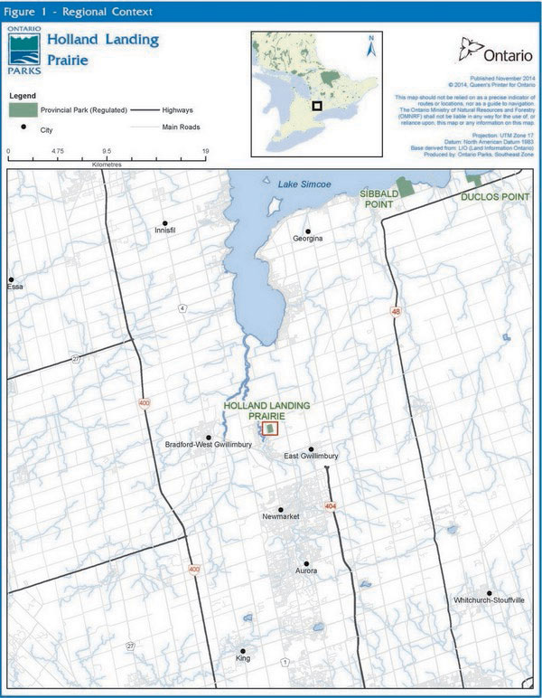
Enlarge Figure 1 - Regional Context map
The park is located in Ecodistrict 6E-6, and is situated within the Simcoe Lowlands physiographic region on the Algonquin Lake Plain. The park’s well-drained soils are primarily Brighton sandy loams, composed of deep deposits of sand and silt underlain by clay till. Due to these geological features and the presence of tallgrass prairie plant communities, this site was designated as an Area of Natural and Scientific Interest (ANSI) in the late 1980's (OMNR 1984).
The park contains 17 Ecological Land Classification community units and three landform/vegetation associations. A total of 305 taxa of vascular plants, 61 species of birds, one amphibian species, two reptile species and seven mammal species have been documented at the site (OMNR 2007).
MNRF's Natural Heritage Information Centre (NHIC) currently tracks five vascular plant species found in the park (i.e., species of provincial conservation concern, ranked S1, S2, S3). Butternut (Juglans cinerea), ranked S3, is classified as endangered by the Committee on the Status of Endangered Wildlife in Canada (COSEWIC), the Committee on the Status of Species at Risk in Ontario (COSSARO) and is listed under regulation and protected under the ESA. The tallgrass prairie plant community found in the park is ranked S1 by the NHIC.
5.1.2 Earth sciences
The park is underlain by fine to coarse-grained glaciolacustrine sand in a low-relief plain containing subtle, low (about one metre high) ridges trending roughly in an east-west orientation. Higher forms (up to three metres high) show more abrupt relief and expose bare sand which contains small blowouts. The surficial features are interpreted to represent nearshore to emerging shoreline features (spits and offshore bars) associated with glacial Lake Algonquin, and small dunes which formed after water levels dropped. The underlying Middle Ordovician bedrock is not exposed in the park (Kor 2007).
The features in Holland Landing Prairie Provincial Park are considered to be locally significant for their representation of glacial Lake Algonquin deposits in the Lake Simcoe basin (Kor 2007).
The uniform sandy substrate is susceptible to erosion if the vegetation cover is disturbed. This is notable in the small dune areas where vegetation removal has caused enhanced wind and runoff erosion and minor local blowouts (Kor 2007).
5.1.3 Cultural heritage resources
The Holland Landing Prairie Provincial Park area is known to have been used by Aboriginal peoples until as recently as 150 years ago as a stopover point during the fur trade. The park is also in close proximity to two known Aboriginal burial sites from the period of the Mississauga tribe.
A formal study of cultural resources has not been performed for the park. See Section 9.3.11 for policy regarding any new resources discovered.
5.2 Recreation objective
The park’s recreation objective is to:
- Manage for ecologically sustainable outdoor recreation opportunities, in a manner which fosters appreciation for the natural heritage values of the park while ensuring the level of protection granted to nature reserve class parks
5.3 Heritage appreciation objective
The park’s heritage appreciation objectives are to:
- Provide opportunities for public outreach, and natural and cultural heritage education which benefit the protection and restoration objectives of the park
- Develop an appreciation for and understanding of prairie ecosystems and the role of Holland Landing Prairie Provincial Park in Ontario’s system of parks and protected areas
5.4 Scientific research objective
The park’s scientific research objective is to:
- Foster scientific research and learning related to the isolated and unique nature of Holland Landing Prairie Provincial Park. MNRF will encourage initiatives which promote learning and scientific understanding about the function and protection of prairie ecosystems, while respecting and protecting the sensitive soil and plant communities. Information gathered through research initiatives may contribute to natural and cultural heritage education objectives
6 Boundary
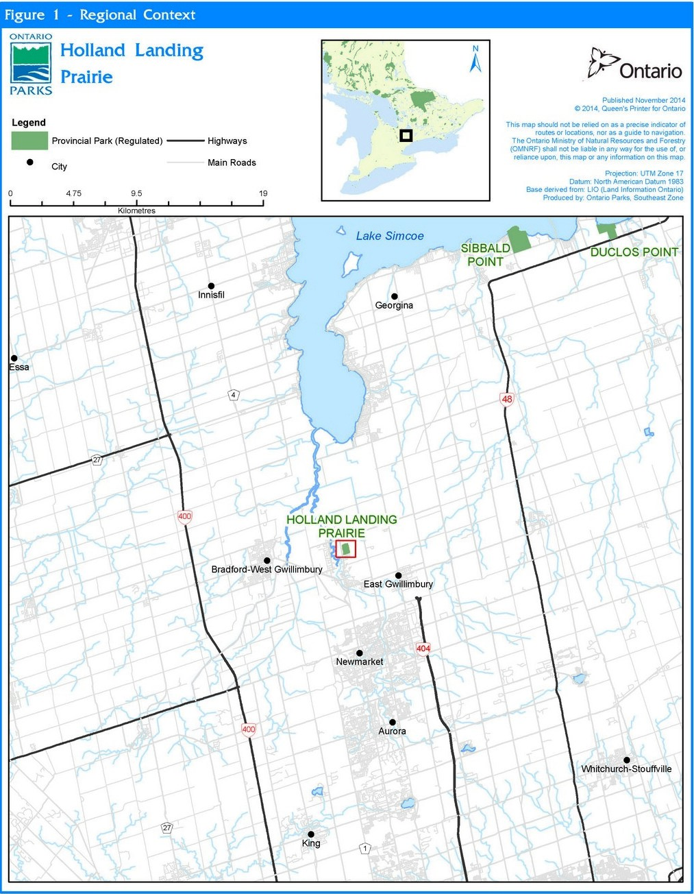
Holland Landing Prairie Provincial Park is located in the Town of East Gwillimbury in the Regional Municipality of York, approximately 10 km south of Lake Simcoe (Fig. 1). This 34.2 ha park was established in 1994, and is currently regulated under the PPCRA (R.R.O. 2007, O. Reg. 316/07, s. 2). The park occupies parts of lots 112, 113 and 114, Concession 1, east of Yonge Street (Fig. 2).
Park management plan policies apply only to the area within the regulated boundary of the park. Within the park boundary, the protection of park values and features will be achieved through appropriate zoning, the control of land use and activities, education, monitoring of ecological impacts and active management and restoration activities.
Figure 2 - Holland Landing Prairie Park Boundary
Enlarge Figure 2 - Park Boundary map
7 Adjacent land uses
Holland Landing Prairie Provincial Park has been identified in the natural heritage strategies of the Town of East Gwillimbury, the Regional Municipality of York and the Lake Simcoe Region Conservation Authority as contributing significantly to the natural heritage values of the region. The park is located adjacent to, but not within, the areas which are governed by the Greenbelt Act, 2005 and the Oak Ridges Moraine Conservation Act, 2001. The property to the north of the park has been identified as a candidate ANSI by the MNRF Aurora District due to the presence of tallgrass prairie communities.
Private lands surround the park, with residential properties abutting the entire western boundary, private, undeveloped lands to the north and east, and a residential subdivision to the south of Cedar Street. A hydro right of way intersects the north-west corner of the site. There are no private lands within the park, nor are there any private land use permits or leases. The park is located in close proximity to a number of local and regional parks and conservation lands.
The Holland Landing sewage lagoons about the south east corner of the park. At the time of writing this management plan, an environmental assessment process was underway by York Region to relocate or improve the facility. The long term use of this site is unknown. Ontario Parks will work with the land managers where possible to encourage compatible adjacent uses which protect or enhance park values.
Much of the land surrounding the park has been identified as a growth plan area in the Growth Plan for the Greater Golden Horseshoe, 2006. Lands to the south, east and west of the park are identified as urban growth areas in the York Region Official Plan and as settlement areas in the Greenbelt Plan and the Town of East Gwillimbury Official Plan. Significant population growth is anticipated for the area over the 20 year lifespan of this management plan.
8 Zoning and zone management policies
Lands within Holland Landing Prairie Provincial Park are zoned in accordance with their natural and cultural resources, and their need for protection. Zones differentiate the sensitivity of the natural and cultural values, and the permissible degree of development, recreational uses and management practices.
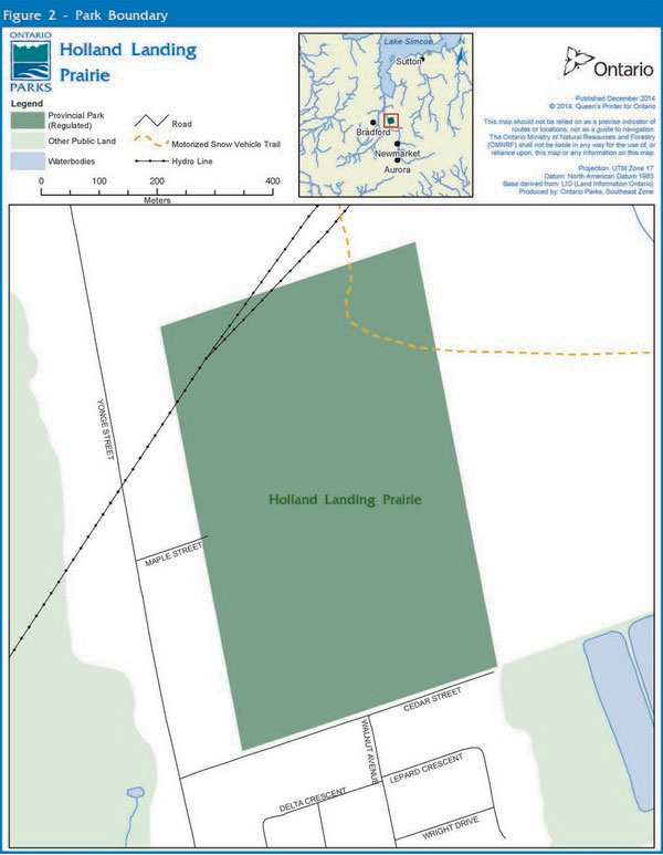
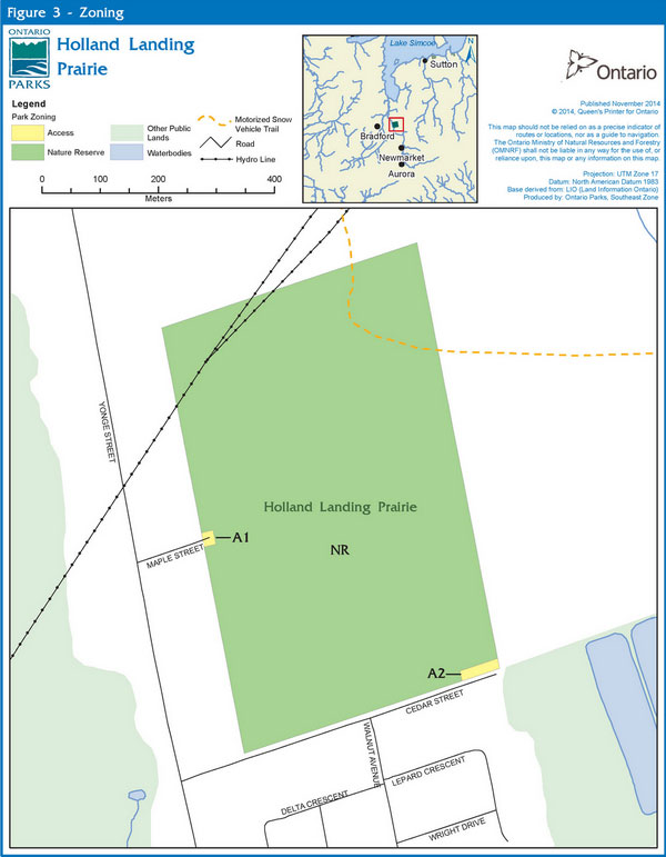
The majority of the land base within the park will be zoned as nature reserve. Two small access zones at the Maple and Cedar Street entrances facilitate park operations and resource management activities (Fig. 3).
8.1 Nature reserve zone
Nature reserve zones protect the provincially significant earth and/or life science features within a park, and may include a protective area in which a minimum of development is permitted. Development is generally restricted to trails, necessary signs, interpretive facilities (where warranted) and temporary facilities for research and management.
8.1.1 NR-1 Holland Landing (34 ha)
Zone NR-1 encompasses nearly the entire land base of the park. This zone protects the unique natural heritage values associated with the provincially rare tallgrass prairie plant communities. Management activities will focus on the protection and restoration of tallgrass prairie and other native plant communities such as native hardwood forest. As part of the restoration efforts, emphasis will be put on the protection and restoration of species at risk and addressing issues of invasive species.
8.2 Access zones
Access zones serve as staging areas; they are a means of both providing and regulating use in areas of a park geared towards recreation. Provisions may be made for limited orientation, interpretive or educational facilities, though generally more for self-use rather than through structured personal service. Limited facilities for research and park management may also be present.
8.2.1 A-1 Maple street access (<0.1 ha)
A small access zone immediately inside the west boundary of the park at Maple Street provides a staging area for resource management, park operations, interpretive and enforcement activities.
8.2.2 A-2 Cedar Street access (<0.2 ha)
A small access zone immediately inside the south boundary of the park at the eastern end of Cedar Street provides a staging area for resource management, park operations, interpretive, and enforcement activities.
9 Park policies
This section provides site specific management policies and any associated actions required to effectively manage Holland Landing Prairie Provincial Park in accordance with applicable legislation and provincial policies.
9.1 Industrial uses
Industrial activities are prohibited in Holland Landing Prairie Provincial Park.
9.2 Commercial uses
The PPCRA allows for the MNRF to enter into commercial agreements with respect to the use and occupation of land in provincial parks. However there are a number of provincial policies governing what type of commercial activities may occur in certain classes of parks and zones within a park.
Commercial resource harvesting, including trapping and bait harvesting are not permitted in the park. There are no existing licences, and new resource harvesting operations will not be considered.
9.3 Resource management policies
The plant communities at Holland Landing Prairie Provincial Park are being increasingly affected by a number of factors including encroachment by woody vegetation, invasive species, established conifer plantations, unauthorized mechanized travel and unauthorized trails. Suppression of natural fire regimes has also been a key stressor on the prairie values which the park was created to protect. Restoration of tallgrass prairie communities is central to the park’s management priorities.
9.3.1 Land management
Many of the park’s neighbours are good stewards; however, significant encroachment is occurring from some abutting properties. Back yard extensions, unauthorized fencing and outbuildings, yard waste disposal and removal of vegetation have had a detrimental effect on the tallgrass prairie communities at the edge of the park. Improved enforcement, fencing and signage, along with consistent communication with adjacent property owners, are required.
The hydro right of way contains the best examples of tallgrass prairie in the park, in part due to regular maintenance activities which remove woody vegetation and favour grasses and forbs.
9.3.1.1 Additions to the park
Ontario Parks will support, in principle, adding property to the park, provided the addition is anticipated to enhance park values. If suitable lands within, nearby or adjacent to the park become available for addition they will be evaluated with regard to their contribution to park objectives, willing seller/willing buyer and other factors including available funding. Any park addition would require a change to regulation and an amendment to the Crown Land Use Policy Atlas.
9.3.2 Water management
There are no water bodies and no water management issues in the park.
9.3.3 Alien and invasive species
Alien species are plants, animals, and micro-organisms that have been unintentionally or deliberately introduced by human activity into areas beyond their normal range. Invasive species are those species whose introduction or spread threatens the environment, the economy and/or society, including human health. Alien species will not be deliberately introduced into the park. Where invasive species threaten natural or cultural values, a control program may be undertaken if feasible and practical.
Without active management, highly invasive species such as garlic mustard (Alliaria petiolata), spotted knapweed (Centaurea maculosa), common buckthorn (Rhamnus cathartica), European swallow-wort (Cynanchum rossicum) and Morrow honeysuckle (Lonicera morrowi), which currently exist in small areas of the park, may potentially significantly increase their current distribution and abundance (OMNR 2006a). In addition, the planted native and alien conifers, as well as the some of the pioneer tree species like poplars are considered alien in the context of the tallgrass prairie habitat, and will be removed in accordance with direction provided in Section 9.3.8.
9.3.4 Extirpated native species
Existing populations may be augmented, and extirpated native species may be reintroduced, if biologically feasible and desirable for perpetuating park values.
9.3.5 Insects and diseases
Infestations of insects and vegetative diseases that are native to the region will normally be allowed to progress naturally. Insect and disease control measures for native and alien species may be considered if the features and/or values of the park are threatened. Infestations by forest insects and diseases may be monitored and assessed.
Emergency measures may be considered to protect the park’s features and values and would be subject to the appropriate MNRF approval.
9.3.6 Fire management
Fire is important for the formation and maintenance of tallgrass prairie communities. In these communities, fire acts as a main disturbance and favours the growth of forbs and grasses while consuming the woody plant material.
Forest fire management in the park will be in accordance with provincial policies and procedures. Holland Landing Prairie Provincial Park is located outside of the fire region of Ontario, as defined by the Forest Fires Prevention Act. Outside the fire region, municipalities have a mandate to provide forest fire protection. The Town of East Gwillimbury is responsible for fire protection and response in Holland Landing Prairie Provincial Park.
Fire management within Holland Landing Prairie Provincial Park will help to restore and maintain ecological integrity while preventing personal injury, loss of values and social disruption. As resources allow, prescribed burning will be used in the park to restore and maintain tallgrass plant communities. Plans for any prescribed burning will be developed in accordance with MNRF policy in cooperation with MNRF fire management staff and/or the municipal fire department.
9.3.7 Species at risk
Species at risk and their habitats will be protected in a manner consistent with the ESA and associated regulations.
9.3.8 Vegetation management
Active vegetation management will be an integral component of park management activities. Over time, the remnant prairie plant communities have become severely degraded due to a number of factors, including the establishment of coniferous plantations, fire suppression, incompatible recreation activities and encroachment from adjacent properties. These issues, along with the need to re-introduce regular disturbance regimes which are critical to the maintenance of prairie ecosystems, must be addressed if the natural heritage values for which the park was established are to be protected.
There is indication that the existing seed bank and plant communities are in sufficiently good condition to support the re-establishment of tallgrass prairie in the park. Gartner Lee Associates Ltd. (1986) examined the effects of an accidental fire which occurred near the Maple Street entrance to the park. The fire resulted in an increase in prairie plant species when compared with areas that had not been burned. In 1994 a small area of the plantation was cleared to allow for regeneration of the prairie vegetation, also resulting in an increase in prairie species, but also a subsequent increase in pioneer tree species like poplars. The results of these two studies suggest that the mimicking of natural disturbance regimes by conifer removal and prescribed burning will have a positive impact on the tallgrass communities.
Techniques that have been proven effective in managing and restoring tallgrass prairie habitats and may be used alone or in combination include: prescribed burning, mowing and cutting of woody vegetation, applying herbicide, scarification, seeding and planting.
The following sections describe vegetation management techniques that may be used within the park.
9.3.8.1 Prescribed burning
Fire is the most effective form of natural disturbance in tallgrass communities and should be introduced through a carefully implemented program of prescribed burning. This will restore and maintain tallgrass prairie species and communities by releasing dormant seed banks and re-establishing natural nutrient cycles. Other benefits of a prescribed burning program may include the control of alien, invasive and perennial woody species that are colonizing former prairie sites.
9.3.8.2 Sand barren stabilization
Unauthorized recreational activities and other human disturbances in the open sand barrens will be managed to allow for the re-establishment of native vegetation. Removal of adjacent conifers and other undesirable vegetation should be delayed until the sand barrens have been stabilized, as these can provide shelter from wind erosion and excessive evaporation. Once the barrens have been stabilized and adequately vegetated, management techniques used in adjacent tallgrass prairie remnants may be applied.
9.3.8.3 Conifer plantation removal
MNRF will phase in the removal of the conifer plantations on the property. These plantations, established in 1946, 1949, and 1975, have created dense shade and a layer of needles on the soil surface, which inhibit the establishment and survival of tallgrass vegetation. Priorities will include expansion of existing areas of tallgrass habitat, and removal of alien, invasive European alder (Alnus glutinosa) and Scots pine (Pinus sylvestris). Where possible, desirable and compatible with prairie protection and restoration goals, a treed buffer will be maintained adjacent to residential areas.
Some plantation areas may be restored to native forest. Conifers may be thinned to create gaps in the overstorey and allow for natural regeneration, or areas may be planted with native tolerant hardwood species.
9.3.8.4 Native forest preservation
Existing native forest, primarily located in the north-east quadrant of the site, will be allowed to develop naturally, and should require little active management. Periodic monitoring will ensure problems are identified and addressed appropriately. Invasive species should be removed wherever possible to prevent their establishment.
9.3.8.5 Removal of vegetation and woody debris
Standing dead trees along trails or roads will be removed if they pose a risk; otherwise they will be left in place to provide wildlife habitat. Broken or rotted limbs or crowns may be removed, leaving the trunk for wildlife habitat wherever possible.
Windthrown trees and live branches may be removed where they impede passage along trails. Wherever possible, only the portion of the tree across the trail will be removed and all remaining wood will be left in place. In natural areas, fallen trees and limbs will be left in place as long as they do not pose a risk to public safety or interfere with prairie restoration efforts.
Standing or fallen trees which are removed for resource management or public safety purposes may be marketed if economical. Removals should occur in winter wherever possible to minimize damage to sandy soils.
The cutting of live vegetation by park users or adjacent property owners is prohibited. Dumping of yard waste and garbage is prohibited.
9.3.8.6 Planting and seeding
Where planting or seeding is necessary, species native to the park will be used, and sources of these species will originate in or near the park wherever possible.
9.3.9 Pesticide and herbicide use
Pesticides and herbicides may be used to control invasive species, protect or restore the habitat of native species, protect or restore rare ecosystems, or for other reasons in accordance with MNRF policy and Ministry of the Environment and Climate Change regulations.
9.3.10 Wildlife management
Animal populations or individual problem animals may be controlled when essential to human health and safety, the health of the species or the values for which the park has been established, or to protect ecological integrity.
Where control is necessary, techniques which have minimal effects on other components of the park’s environment will be used. Appropriate methods of population control may be undertaken directly by Ontario Parks or through partnerships under the strict supervision of Ontario Parks.
9.3.11 Cultural resources management
A formal study of cultural resources may be completed for the Holland Landing Prairie Provincial Park.
The management of cultural heritage resources within the park will be directed towards protection, heritage appreciation and research. Cultural heritage resources will be protected, maintained, used and disposed of in accordance with the protected areas mandate (legislation and policies) and the evaluation process developed by MNRF consistent with the Standards and Guidelines for Conservation of Provincial Heritage Properties (Ontario Heritage Act, 2005). Staff will also consult MNRF's Technical Guideline for Cultural Heritage Resources.
If cultural heritage resources are discovered, decisions on activities that may affect them shall be based on appropriate studies and research (including analysis of physical, documentary and oral evidence) aimed at understanding the cultural heritage resource, including its level of significance (e.g., local, regional, provincial), the impact of proposed activities on the resource, and measures to mitigate these impacts.
All areas of archaeological potential that may be affected by activities associated with park design investigations, construction, operation or maintenance will undergo archaeological assessment. These activities may include any form of soil disturbance or alteration including testing, excavating, grading, capping and filling. Archaeological resources will be identified and evaluated in accordance with the processes documented in the Standards and Guidelines for Consultant Archaeologists (OMTC 2011).
Controls to protect sites will be established where required.
The removal of artefacts, or the disturbance or destruction of historical features, is illegal and prohibited.
9.3.12 Research
MNRF encourages scientific research by qualified individuals contributing to the knowledge of natural and cultural heritage and to environmental management. Ontario Parks will review proposed research to ensure adequate consideration of potential impacts on protected area resources, features, staff and visitors.
Research activities require authorization issued under the PPCRA and must be consistent with relevant policies. Research must meet all requirements under applicable provincial and federal legislation, and may require additional permits or approval (e.g., MNRF Wildlife Scientific Collector authorization or ESA permits).
Ontario Parks may consider allowing temporary facilities in support of approved research and monitoring activities. Sites altered by research activities must be rehabilitated as closely to their previous condition as possible, except where the specific intent of the research activities is disturbance for the purpose of ecological enhancement or restoration.
Specific research initiatives may include:
- The role of fire in restoring central Ontario prairie
- Long term seed bank retention within plantations
- Rate of spread of prairie vegetation into newly opened sites
- Tallgrass prairie ecology, restoration and management
- Managing the nature reserve to maintain or restore ecological integrity in the context of increasing urbanization and resulting pressures
- Archaeology and cultural heritage
Particular emphasis will be placed on the implementation and long-term monitoring of prairie restoration techniques. Research regarding the cultural heritage of the park will also be encouraged, including archaeological studies and historical reviews.
9.3.13 Inventory and monitoring
Planning and management decisions are intended to ensure the ecological integrity of protected areas. Consideration will be given to social and economic components.
Ontario Parks will ensure that these decisions are made with the best available information. Where this information is lacking, Ontario Parks may conduct inventories and monitoring, as necessary, to provide this information. Such efforts will be undertaken based on established methodologies and best practices.
Inventory and monitoring will foster an adaptive management approach to protected areas management.
Priority monitoring projects include:
- Rates of change in composition of vegetation communities with management towards the goal of prairie restoration
- Change in quantity, diversity, and distribution of significant prairie species
- Effects of, and recovery from, incompatible recreation activities
- Butternut health, regeneration and occurrence
9.4 Recreation management policies
Where compatible with park values and the maintenance of ecological integrity, low-intensity, day-use activities that promote public awareness and enhance appreciation of the park’s natural and cultural heritage will be permitted. Recreation will be limited to pedestrian travel (i.e. walking, snowshoeing, and skiing) on designated trails (Section 9.4.4) and use of the existing motorized snow vehicle trail which runs through the north east quadrant of the park (Section 9.4.3). Park facilities will be designed with protection and restoration of ecological integrity as the first priority.
9.4.1 Services for visitors
There are currently no facilities for visitors in the park. Services may eventually include formalized trails and a self-guiding interpretive program. Washrooms facilities will not be provided.
9.4.2 Hunting
Hunting is not permitted.
9.4.3 Mechanized travel
An agreement with the Holland Landing Snowmobile Club allows for access and maintenance of a motorized snow vehicle trail through a portion of the park (Fig. 3). Records indicate that the original trail ran north-south along the east boundary of the park. While most of the motorized snow vehicle trail has been rerouted outside the park boundary, a small section continues to run through the north east quadrant of the park. Motorized snow vehicles are permitted only on the designated trail. This is a pre-existing, non-conforming use that will continue within the park. Expansion of the motorized snow vehicle trail will not be permitted.
Should the snowmobile club no longer require access to the portion of the trail which runs through the park, this use of the trail by motorized snow vehicles will be permanently discontinued. The trail may continue to be maintained for pedestrian travel unless park values are compromised. Opportunities to move the trail outside the park boundary will be considered.
New trails for all other mechanized travel inside the park will not be permitted. Motorized vehicles, including ATVs and trail bikes, are prohibited. Bicycles are not permitted.
Unauthorized use of ATVs and motorized trail bikes is an on-going management concern, and has resulted in significant soil erosion and damage to vegetation. Fencing and signage installed by Ontario Parks and the local snowmobile club have to date been unsuccessful in excluding these activities. Controlling access and eliminating unauthorized mechanized use will continue to be a priority for enforcement.
Ontario Parks staff may use ATVs or other vehicles for park maintenance purposes as directed by the park superintendent. Hydro One may use mechanized travel along the existing right of way only, to access their facilities within the hydro corridor. The lowest impact equipment available should be used.
9.4.4 Trails and other recreational uses
The proximity of Holland Landing Prairie Provincial Park to residential development makes it a desirable destination for passive recreational activities such as walking and nature enjoyment. The formalization of a trail system through the park could help to control access and encourage responsible use. Partnerships with the Town of East Gwillimbury and/or the Regional Municipality of York would allow for integration with other local trail strategies.
An existing trail for pedestrian travel (i.e. walking, snowshoeing, and skiing) follows the original motorized snow vehicle trail along the east boundary of the park. Additional informal trails run throughout the site. Several trails have been created by unauthorized ATVs and other off-road vehicle use.
A formalized network of designated trails may be developed to provide natural and cultural heritage education opportunities and compatible non-mechanized recreational access through the site, while protecting the values of the park. Authorized trails may be re-routed; all other trails will be closed. Trails may be improved to minimize erosion and protect park values; however, no impermeable surfaces will be permitted. Trail conditions will be monitored and sections may be temporarily or permanently closed to prevent erosion, trampling, rutting and widening. All trails will be designed and managed with ecological integrity as the first priority.
To the extent possible, trails will be designed to coordinate with local and regional trail plans and active transportation networks.
Recreational use will be geared toward passive activities such as walking, snowshoeing, skiing, nature appreciation, and self-guided interpretive learning for visitors.
Camping, horseback riding, and picnicking are not permitted.
Figure 3 - Holland Landing Prairie Zoning
9.4.5 Emerging recreation uses
Adventure racing is not permitted.
Virtual geocaching may be considered as a recreational use subject to approval by the park superintendent. Physical geocaching will not be permitted.
There are emerging recreational uses for which no current or limited management policy exists. New activities must be reviewed to determine if they are consistent with legislation, regulations and policies and compatible with park values. An adjustment to the management plan may be required.
9.5 Operations policies
Holland Landing Prairie Provincial Park is currently a non-operating park. As such, operations will be limited to management and enforcement activities which protect or restore the natural and cultural heritage values of the park.
At Holland Landing Prairie Provincial Park, there will be an emphasis on self-guided interpretative opportunities.
- Park information and interpretation will be delivered through printed materials, signage, panels or displays, and informal communications with park staff
- Partnerships with local tourism authorities to relay information to park visitors and potential park visitors may be pursued
9.5.1 Partnerships
In the implementation of the park management plan, Ontario Parks may pursue opportunities for partnerships involving other agencies and groups through formal partnership agreements. Partners may represent the local community, and local and provincial interests. Partners will work with Ontario Parks to assist in the implementation of the management plan and will follow provincial park policies and regulations.
The partnership with the local snowmobile club has been successful and will continue to be fostered, where it remains beneficial to the management goals of the park. Partnerships with the Town of East Gwillimbury, the Regional Municipality of York and the Lake Simcoe Region Conservation Authority may continue to be pursued and formalized. In particular, partnerships relating to the management of park trails may be formalized. Partnerships with local naturalist groups, cultural organizations, and other agencies with an interest in the special natural and cultural heritage features of the park may be pursued.
9.6 Marketing and communications policies
9.6.1 Marketing
A marketing plan will not be developed for this park, unless a significant need or opportunity arises.
9.6.2 Communications
Information regarding the park will be made available through the Ontario Parks website, at Holland Landing Prairie Provincial Park, where feasible, and at Sibbald Point Provincial Park. Where appropriate, information may also be made available through local sources such as naturalist and trail groups, the municipality and other local organizations.
9.7 Development policies
All development undertaken by Ontario Parks or by third parties on its behalf will comply with the Class EA-PPCR, and will be carried out in accordance with approved site and development plans that meet standards for provincial parks.
Areas proposed for development will require prior assessment for cultural heritage resources (see Section 9.3.11) and significant natural heritage values, such as species at risk, to ensure these values are identified and protected at the site.
Any development within the park boundary will require approval from the park superintendent, and may require applicable work permits. All developments will be located and designed to avoid or minimize negative impacts to the prairie communities and other natural and cultural values.
9.7.1 Internal roads
There are no roads in the park. New roads are prohibited.
9.7.2 Access and parking
The park can be accessed at the east end of Maple Street and from the north side of Cedar Street (Fig. 3).
The Cedar Street entrance will be identified as the primary access point for park visitors.
Informal parking is available on Maple Street and Cedar Street. Some local residents have expressed concerns about on-street parking for the purposes of access to the park. Formal parking areas will be considered and implemented if demand warrants and resources allow. These parking areas will consist of seasonal parking for up to four vehicles with turnaround in the access zone off Maple Street, and up to six vehicles in the access zone off Cedar Street.
Coordination may be required with the municipality to restrict on-street parking if this continues to be a concern. Parking areas within the park may be closed by the park superintendent at any time for health and safety, operational or resource management reasons. Closure may be temporary or permanent.
Interpretive kiosks may be installed at the park access points at Cedar and Maple Streets.
9.7.3 Campgrounds, day use areas, roofed accommodations, maintenance and administrative areas
The development of campgrounds, day-use facilities, roofed accommodations, and maintenance and administrative areas is not permitted in the park.
10 Implementation priorities
Park management, development and operations proposals will be phased in, to the extent possible, as follows:
- Implement tallgrass prairie restoration and protection activities as described in Section 9.3, including:
- Maintenance and enhancement of tallgrass prairie remnants in the hydro corridor and other non-forested sites
- Removal of invasive species (such as dog strangling vine) which threaten prairie values
- Connecting and enlarging existing areas of tallgrass habitat through phased in removal of conifer plantations and restoration to prairie habitat
- Stabilization of active sand barrens areas
- Identify, map and formalize an approved trail system as described in Section 9.4.4
- Repair and/or install fencing around the perimeter of the park, clearly identify park boundary and access points, and install or replace signs as required as identified in Section 9.3.1
- Identify, assess and manage the park’s known and potential cultural heritage resources, in accordance with Section 9.3.11
- Design and install a self-guided interpretive sign program as identified in Section 9.5
- Develop parking areas at access points as identified in Section 9.7.2
Implementation of the above actions is subject to applicable legislation and provincial policy, the Class EA-PPCR and availability of financial and human resources.
11 Plan examination and adjustment
This management plan will be examined in accordance with the provisions of the PPCRA to determine whether the management direction is still relevant, effective and current or if adjustment is required. In circumstances where the plan is not providing sufficient direction to protect the values or address existing or emerging pressures the plan can be examined prior to the next scheduled examination.
External requests for adjustments to address specific requests or needs may be considered. Ontario Parks can provide further guidance to external parties on the process for requesting an adjustment for this plan and whether specific requests can/will be considered.
12 Involvement
Aboriginal community and public involvement have played a very important part in the Holland Landing Prairie Provincial Park management planning process. The following is a summary of involvement undertaken for this planning process:
12.1 Summary and results of aboriginal community involvement
- Phase 1 - Invitation to Participate; Holland Landing Prairie Provincial Park Terms of Reference and Background Information
During the involvement period to review the terms of reference and comment on the background information (April 9 – May 26, 2009), an invitation to participate was sent to the Union of Ontario Indians, Chiefs of Ontario, Ogemawahj Tribal Council and the Chippewas of Georgina Island. No formal response was received to date from these groups.
- Phase 2 – Preliminary Management Plan
An invitation to participate and a copy of the preliminary management plan were sent to the above noted communities and Provincial Treaty Organizations as part of this planning stage. A letter from the Georgina Island First Nation indicating receipt of the invitation to participate was received by Ontario Parks. No comments were provided.
Participation was encouraged at any time during the management planning process.
12.2 Summary and results of public involvement
- Phase 1 - Invitation to Participate; Holland Landing Prairie Provincial Park Terms of Reference and Background Information
The Holland Landing Prairie Provincial Park Terms of Reference was approved in February 2008. The Invitation to Participate and Inspect the Approved Terms of Reference and Background Information was released for public review on April 9, 2009. Letters were mailed to persons and organizations on the park planning mandatory contact list, stakeholders and interested persons, and an announcement was made through a newspaper notice in the Era Banner. Bulletins were posted in Sibbald Point Provincial Park and a notice was posted on the EBR Environmental Registry. A 46-day period was provided to allow interested individuals and parties to submit comments.
Nine written comments were received from the public. Comments related primarily to support for protection and restoration of ecological values, concerns over damage by unauthorized vehicles such as all-terrain vehicles (ATVs) and trail bikes, and requests to be added to the mailing list for future management planning communications.
- Phase 2 – Preliminary Park Management Plan
During this phase of involvement, the public was offered an opportunity to review and comment on the proposed management policies and activities for Holland Landing Prairie Provincial Park. Invitations to participate were mailed to persons and organizations on the park planning mandatory contact list, local landowners, stakeholders and interested individuals. The 45-day review and comment period, April 4 to May 19, 2011, was announced through a newspaper notice in the Aurora Era Banner and a posting on the EBR Environmental Registry. Notices were also posted at the Cedar and Maple Street entrances to the park. A public information session was held on April 19, 2011, at the River Drive Park Community Centre in East Gwillimbury.
Twenty four people attended the public information session. Thirteen comments were received, and one comment received outside of the review period was also considered. The majority of comments supported the plan’s focus on tallgrass prairie protection and restoration objectives, although some requested stronger language and clearer direction in support of this mandate. Additional focus on the cultural heritage values of the park was also requested. Some respondents expressed concern about access from Maple Street and requested that a parking area be created. Several comments were received regarding the importance of the walking trails to the local community and the need to formalize these and connect them to regional and local trail planning initiatives. Some concern was expressed regarding the proposal to phase out conifer plantations. These related to the need for buffers on residential areas, the aesthetic qualities of treed walking trails, and a concern for displaced wildlife. Unauthorized use, such as access by motorized vehicles and pit parties, was identified by many respondents as a significant ecological, safety, and aesthetic concern, and the need for better access control and enforcement was expressed.
This management plan incorporates many of the comments received:
- Added references and rationale to conifer plantation phase out and allowances for the maintenance of treed buffers in Section 9.3.8 Vegetation Management
- Added emphasis on protection of cultural heritage values in Section 5.1 Objectives
- The enabling of potential designated parking areas in access zones in Section 9.7.2 Access and Parking; and
- The enabling of partnership opportunities recognizing potential for local and regional trail strategies in Section 9.5.1 Partnerships
13 Key references
Chapman, L.J. and D.F. Putnam. 1984. The Physiography of Southern Ontario. 3rd ed. Ontario Geological Survey, Special Volume 2. Accompanied by Map P.2715, scale 1:60,000.
Environment Canada. 2004. Canadian Climate Normals 1971-2000. Available online at: http://www.climate.weatheroffice.ec.gc.ca. Accessed July 3, 2007.
Gartner Lee Associates Ltd. 1985. Study Proposal: Holland Landing Prairie Research. Markham, ON. Prepared for Ontario Ministry of Natural Resources (OMNR).
Gartner Lee Associates Limited. 1986. Holland Landing Prairie Study. Markham, ON. Prepared for South Lake Simcoe Conservation Authority, Newmarket.
Gruenig, N.F. 2001. Holland Landing Prairie Nature Reserve Vegetation Management and Enhancement Plan. Prepared for Dr. Stephen D. Murphy, Technical Advisor, University of Waterloo, Environment and Resource Studies.
Hilditch, T. and D. Cunningham. 1982. Holland Landing Prairie. A research proposal: rehabilitation of the prairie community within the Holland Landing environmentally significant area. South Lake Simcoe Conservation Authority.
Lake Simcoe Region Conservation Authority. 2000. State of the Watershed Report: East Holland River Subwatershed. Available on line at: http://www.lsrca.on.ca/Studies/EastHollandReport.html
Ontario Heritage Act, 2005.
Ontario Ministry of Municipal Affairs and Housing. 2005. Greenbelt Plan. Queen’s Printer for Ontario.
Ontario Ministry of Natural Resources (OMNR). 1983. Maple District Land Use Guidelines.
OMNR. 1984. Life Science Areas of Natural and Scientific Interest in Site District 6-8: A review and Assessment of Significant Natural Areas in Site District 6-8, prepared by R. Hanna. Richmond Hill, ON: Parks and Recreational Areas Section, OMNR, Central Region.
OMNR. 1988. A Biological Inventory and Evaluation of the Holland Landing Prairie Relict, prepared by J. Gould. Richmond Hill, ON: Parks and Recreational Areas Section, OMNR, Central Region. Open File Ecological Report 8804.
OMNR. 1989. Distribution and Status of the Vascular Plants of Central Region, prepared by J.L. Riley. Richmond Hill, ON: OMNR, Parks and Recreational Areas Section, Open File Ecological Report SR8902, Central Region.
OMNR. 1992. Ontario Provincial Parks Planning and Management Policies. Toronto, ON: Queen’s Printer for Ontario.
OMNR. 1994. Ontario Regulation 768/94. Gazette, V (127-52).
OMNR. 1995. Holland Landing Prairie Provincial Nature Reserve Interim Management Statement. Richmond Hill, ON.
OMNR. 1997a. Natural Heritage Resources of Ontario: Bibliography of Life Science Areas of Natural and Scientific Interest in Ecological Site Regions 6E and 7E, prepared by J.L. Riley, J.V. Jalava, M.J Oldham, and H.G Godschalk. Queen’s Printer for Ontario.
OMNR. 1997b. Prescribed Burn Planning Manual. Queen’s Printer for Ontario.
OMNR. 1999. Adaptive Management Forum: Linking Management and Science to Achieve Ecological Sustainability, edited by G.B. MacDonald, J. Fraser, and P. Gray. Peterborough, ON.
OMNR. 2002. Natural Heritage Information Centre. Queen’s Printer for Ontario.
OMNR. 2003. Fire in Parks and Conservation Reserves Background Report. Queen’s Printer for Ontario.
OMNR. 2004a. Forest Fire Management Strategy for Ontario. Queen’s Printer for Ontario.
OMNR. 2004b. Fire Management Policy for Provincial Parks and Conservation Reserves. Peterborough, ON: Planning and Research Section, Ontario Parks.
OMNR. 2004c. A Class Environmental Assessment for Provincial Parks and Conservation Reserves. Queen’s Printer for Ontario.
OMNR. 2005. Detailed Inventory of Butternut (Juglans cinerea) in 12 Central Ontario Provincial Parks, prepared by M. Thompson. Huntsville, ON: OMNR, Central Zone Office, Ontario Parks.
OMNR. 2006a. Holland Landing Prairie Area of Natural and Scientific Interest-Significant Species, prepared by J.B. Korol. Huntsville, ON: OMNR, Central Zone Office, Ontario Parks.
OMNR. 2006b. Natural Fire Regimes in Ontario, prepared by M. Van Sleeuwen. Toronto, ON: Queen’s Printer for Ontario.
OMNR. 2006c. Technical Guideline for Cultural Heritage Resources for Projects Planned under the Class Environmental Assessment for MNR Resource Stewardship and Facility Development Projects and the Class Environmental Assessment for Provincial Parks and Conservation Reserves. Queen’s Printer for Ontario.
OMNR. 2007. A Detailed Life Science Inventory of Holland Landing Prairie Provincial Nature Reserve, prepared by J.B. Korol. Huntsville, ON: OMNR, Central Zone Office, Ontario Parks.
OMNR. 2007. Earth Science Inventory Checklist. Holland Landing Prairie Provincial Nature Reserve, prepared by P. Kor.
Ontario Ministry of Tourism and Culture (OMTC). 2010. Standards and Guidelines for Conservation of Provincial Heritage Properties. Available online at: http://www.mtc.gov.on.ca/en/publications/Standards_Conservation.pdf
OMTC. 2011. Standards and Guidelines for Consultant Archaeologists. Available online at: http://www.mtc.gov.on.ca/en/publications/SG_2010.pdf
Ontario’s Provincial Parks and Conservation Reserves Act, 2006
Reznicek, A.A. 1980. John Goldie’s 1819 Collecting Site near Lake Simcoe, Ontario. Canadian Field-Naturalist, 94(4): 439-442.
Reznicek, A.A. 1983. Association of relict prairie flora with Indian trails in central Ontario. In R. Brewer, ed. Proceedings of the eighth North American prairie conference. Kalamazoo, Michigan: Western Michigan University.
Rodger, L. 1998. Tallgrass Communities of Southern Ontario: A Recovery Plan. Report prepared for World Wildlife Fund Canada and the OMNR. Available online at: http://tallgrassontario.org/Publications/TallgrassRecoveryPlan.pdf
Statistics Canada. 2002. 2001 Community Profiles – East Gwillimbury and York Region, Ontario. Statistics Canada Catalogue no. 93F0053XIE. Available online at: http://www12.statcan.ca/english/Profil01/CP01/Index.cfm?Land=E Accessed June 29, 2007.
Statistics Canada. 2007. East Gwillimbury and York Region, Ontario (table). 2006 Community Profiles. 2006 Census. Statistics Canada Catalogue no. 92-591-XWE. Ottawa. Available online at: http://www12.statcan.ca/english/census06/data/profiles/community/Index.cfm?Land=E. Accessed June 29, 2007.
The Corporation of the Town of East Gwillimbury. Official Plan 1997, Town of East Gwillimbury.
The Regional Municipality of York. 2007. Draft York Region: Natural Heritage Discussion Paper. Available online at: http://www.york.ca/Publications/Default+Economic+Publications.htm (link is no longer active)
The Regional Municipality of York. 2008. York Region Official Plan – office consolidation. Available online at: http://www.york.ca/Publications/Default+Economic+Publications.htm (link is no longer active)