Ivanhoe Lake Provincial Park Management Plan: Amendment
This document provides direction on the management of Ivanhoe Lake Provincial Park.
Management Plan - Minor Amendment
Ontario 2006
Approval statement
I am pleased to approve this Minor Amendment to the Ivanhoe Lake Provincial Park Management Plan. This minor amendment is a statement of policy update to the original management plan (OMNR 1986).
This minor amendment is based on the direction in Ontario’s Living Legacy Land Use Strategy (OMNR 1999) to add the Ivanhoe Provincial Park Addition to Ivanhoe Lake Provincial Park. The original park management plan and this minor amendment address policies for protection, management and development of all lands and waters that are now regulated as part of Ivanhoe Lake Provincial Park (O. Reg. 180/05). In combination, the existing park management plan and this minor amendment provide guidance for the protection, management and development of all lands and waters within the new regulated park boundary under the Provincial Parks Act.
Signed by:
Paul Bewick
Zone Manager
Northeast Zone
Ontario Parks
Date:
December 6, 2006
1.0 Introduction
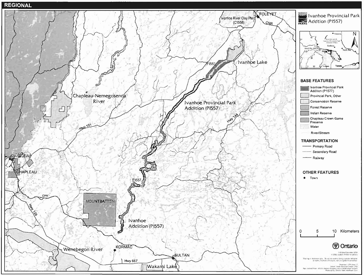
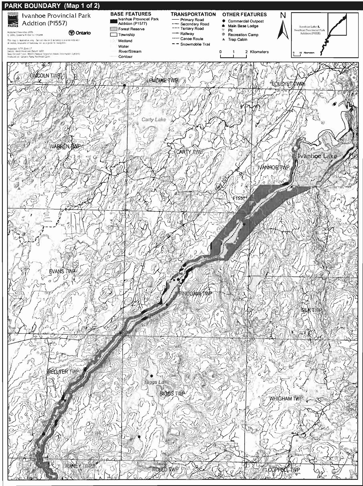
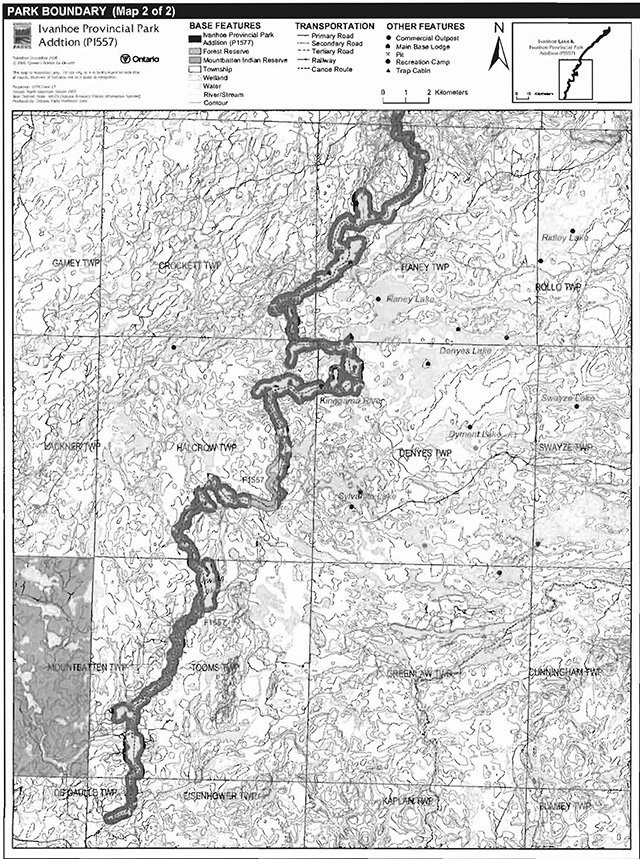
Ivanhoe Provincial Park Addition (P1557) extends between the small hamlet of Kormack to the existing Ivanhoe Provincial Park, near Foleyet (Figure 1). Originating at a small headwater lake of the Kinogama River, the park addition joins the Ivanhoe River in Crockett Township and continues to the northeast until it joins Ivanhoe Lake. This natural environment class park addition is limited to 200 meters from the water’s edge for most of its length, until it reaches a valley located to the southwest of the main basin of Ivanhoe Lake, where it widens to include most of the valley’s slopes. The Ivanhoe Provincial Park Addition joins 6,100 hectares to the original 1,605-hectare Ivanhoe Provincial Park (Figure 2a and 2b).
1.1 Objectives
Ivanhoe Provincial Park Addition will be managed according to the four objectives for provincial parks:
Protection: To protect provincially significant elements of the natural and cultural landscapes of Ontario.
Recreation: To provide provincial park outdoor recreation opportunities ranging from highintensity day-use to low-intensity wilderness experiences.
Heritage Appreciation: To provide opportunities for exploration and appreciation of the outdoor natural and cultural heritage of Ontario.
Tourism: To provide Ontario’s residents and out-of-province visitors with opportunities to discover and experience the distinctive regions of the Province.
2.0 Management context
The purpose of this minor amendment is to provide direction to ensure the custodial management of park resources. Future park planning may be undertaken as required to provide direction on significant decisions regarding resource stewardship, development, operations and permitted uses.
Park management will follow direction from:
- Provincial Parks Act (1990) and regulations
- Ontario Provincial Parks Planning and Management Policies (OMNR 1992)
- Ontario’s Living Legacy Land Use Strategy (OMNR 1999) and policy clarifications (OMNR 2000), amendments, and related direction
- Crown Land Use Policy Atlas (OMNR 2004a)
In addressing custodial management obligations to protect park values and ensure public health and safety, Ontario Parks will ensure that policy and Environmental Assessment Act (1990) requirements are implemented.
2.1 Environmental Assessment
As a part of the Ontario Ministry of Natural Resources (MNR), Ontario Parks is a public sector agency which is subject to the Environmental Assessment Act. Park management will be carried out in accordance with legislation, policies, and guidelines that are required under A Class Environmental Assessment for Provincial Parks and Conservation Reserves (OMNR 2005a).
Figure 1: Regional setting
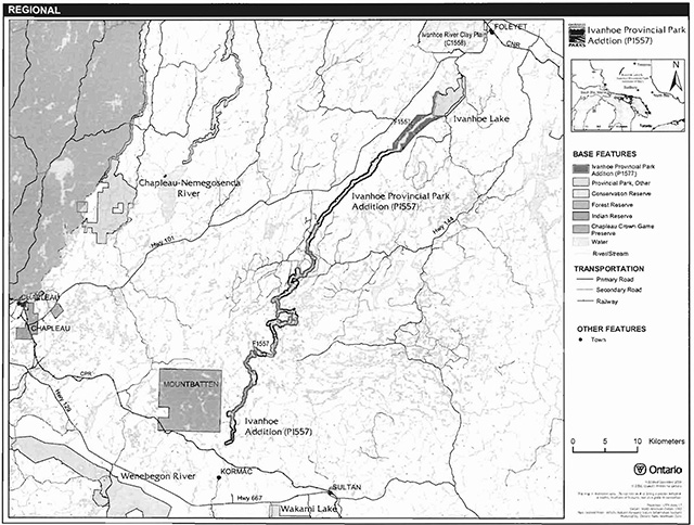
Enlarge figure 1 regional settings map of Ivanhoe Provincial Park
Figure 2a: Park boundary
Enlarge figure 2a Park boundary map of Ivanhoe Provincial Park
Figure 2b: Park boundary
Enlarge figure 2b Park boundary map of Ivanhoe Provincial Park
3.0 Park features and values
The Ivanhoe Provincial Park Addition occupies an area between two ancient proglacial lake basins, in a landscape that is mainly dominated by till deposits. The main forests of the Addition include intolerant hardwoods and mixedwood, Jack Pine and upland conifers, and lowland coniferous forests (Morris 2004).
3.1 Geological features
At its origin near Kormak, the Kinogama River flows through a weakly to moderately broken glaciolacustrine sand plain. Within the park Addition, the till has typically been reworked by the Kinogama River and its predecessors into more contemporary fluvial deposits. North of Halcrow Lake, up to and including the confluence between the Kinogama and Ivanhoe Rivers, the fluvial signatures are less prominent and the principal landform appears to be till.
The Kinogama River flows into the Ivanhoe River in Crockett Township, which then flows northeast into Raney Township. Here the river passes through a section of glaciofluvial icecontact terrain, as indicated by an esker which crosses a large bay in the river. The river then passes through a complex bedrock-controlled valley before returning to moderately broken glaciofluvial ice-contact terrain. From Hellyer Township to Ivanhoe Township, the river follows a major bedrock fault. In this section, surficial features include moderately broken glaciolacustrine deposits, bedrock-controlled valley slopes, and organic deposits situated adjacent to the river.
As the Ivanhoe River approaches Ivanhoe Lake, both the river valley and the park boundary widen. In the valley, the uplands are dominated by shallow to moderately deep till, while small, low relief areas near the river are dominated by glaciolacustrine deposits. The section of the park addition that is directly opposite the existing Ivanhoe Lake Provincial Park is dominated by glaciofluvial ice-contact terrain.
There are components of the bedrock geology that are regionally significant. The surficial geology is locally significant.
3.2 Biological features
The main forests of the park Addition include intolerant hardwoods and mixedwood, Jack pine and upland conifers, and lowland coniferous forests. Only a few small stands of red pine, mixed tolerant hardwoods, and lowland hardwood bottomlands occur here (Morris 2004).
Non-forest vegetation types include conifer swamps, open wetlands, thicket swamps, and rock barrens (Morris 2004).
The park addition includes many moose aquatic feeding areas. There is one known Walleye spawning area in the Addition. A large waterfowl staging and nesting area is located immediately west of the existing Ivanhoe Lake Provincial Park. Osprey nesting sites are also present in the park addition (Morris 2004).
The Ivanhoe Provincial Park Addition contains provincially significant representative open fen vegetation on organic, glaciolacustrine, till, and glaciofluvial ice-contact landforms.
3.3 Cultural setting
A detailed survey and analysis of the cultural history and features of the Ivanhoe Lake Provincial Park Addition has not yet been completed.
Any future planning will be within the context of a provincial framework, A Topical Organization of Ontario History (OMNR 1974). In addition, updates and discussions with First Nations, other agencies and stakeholders may be carried out to identify cultural heritage values and features within the park and their significance. This information may be used to develop management guidelines to conserve and protect representative archaeological and historical values and features, or to provide direction for further research.
3.4 Recreation
The prominent recreational features of the Ivanhoe Provincial Park Addition are water-related activities such as canoeing and boating. The existing canoe route can be accessed by a variety of means, including the CPR line to the south, various logging roads, a river crossing at the south end of the Addition, and by floatplane. A series of rapids within the Addition can be navigated by canoe or kayak. Other recreational activities include wildlife viewing, hunting, and fishing.
4.0 Aboriginal uses
The Ivanhoe Provincial Park Addition is located within the Treaty 9 area of 1905. At the south end of the park addition, to the west, is the Mountbatten Indian Reserve No 76A. Near Chapleau is the Chapleau Indian Reserve (No. 61,61A, 74, 74A, 75), the Duck Lake Indian Reserve (No. 76B) and the Chapleau Cree Fox Lake Indian Reserve.
First Nations have expressed interest in and have shared knowledge of the park and surrounding area. Aboriginal communities have used the area for hunting, trapping, fishing, gathering and travel. These uses may continue, subject to public safety, conservation and other considerations.
Any communications and cooperation between Aboriginal communities and the MNR for planning and operations purposes will be done without prejudice to any future discussions or negotiations between the government of Ontario and Aboriginal communities.
5.0 Stewardship policies
Non-native species will not be deliberately introduced into the park. Where non-native species are already established and threaten park values (i.e., has become invasive), a strategy to control the species may be developed (OMNR 1992).
5.1 Terrestrial ecosystems
The removal, damage or defacing of Crown properties, natural objects, relics and artefacts is not permitted in provincial parks (Provincial Parks Act).
5.1.1 Vegetation
Harvesting
Commercial forest operations are not permitted within the park Addition (OMNR 1992).
Existing authorized wild rice harvesting may continue. New operations will not be permitted. The harvest of non-timber forest products such as club moss, Canada yew, etc., will not be permitted within the park (OMNR 1992).
There are no fuelwood cutting permits currently issued for the park. New permits will not be issued (OMNR 2000).
Insects and disease
Insects and diseases may be managed where the aesthetic, cultural, or natural values of the park are threatened (OMNR 1992). Control measures will follow guidelines established by the Ontario Ministry of the Environment (MOE) and MNR. Whenever possible, biological control measures will be given preference over the use of chemicals (OMNR 1992).
Fire
Ivanhoe Provincial Park Addition is located within the Boreal Fire Management Zone. Consistent with existing provincial park policy and the Forest Fire Management Strategy for Ontario, forest fire protection will be carried out in the park as on surrounding lands (OMNR 2004b). Whenever feasible, MNR's Forest Fire Management program will use techniques that minimize damage to the landscape, such as limiting the use of heavy equipment or limiting the number of trees felled during response efforts (OMNR 2004b).
5.1.2 Wildlife Management
The Ivanhoe Provincial Park Addition is located within Wildlife Management Unit 31. The removal or harassment of non-game animals is not permitted in provincial parks (Provincial Parks Act).
Hunting
Sport hunting is permitted to continue. Considerations of safety and conservation with respect to hunting may be made through future management planning, which includes public consultation (OMNR 2000). Hunting is not permitted within the original Ivanhoe Provincial Park.
The Fish and Wildlife Conservation Act (1997) and the Migratory Birds Convention Act (1994) govern hunting within the park. The Ontario Hunting Regulations Summary contains regulations specific to this area. The harvest of bullfrogs or snapping turtles is illegal in provincial parks.
Bear Management Areas
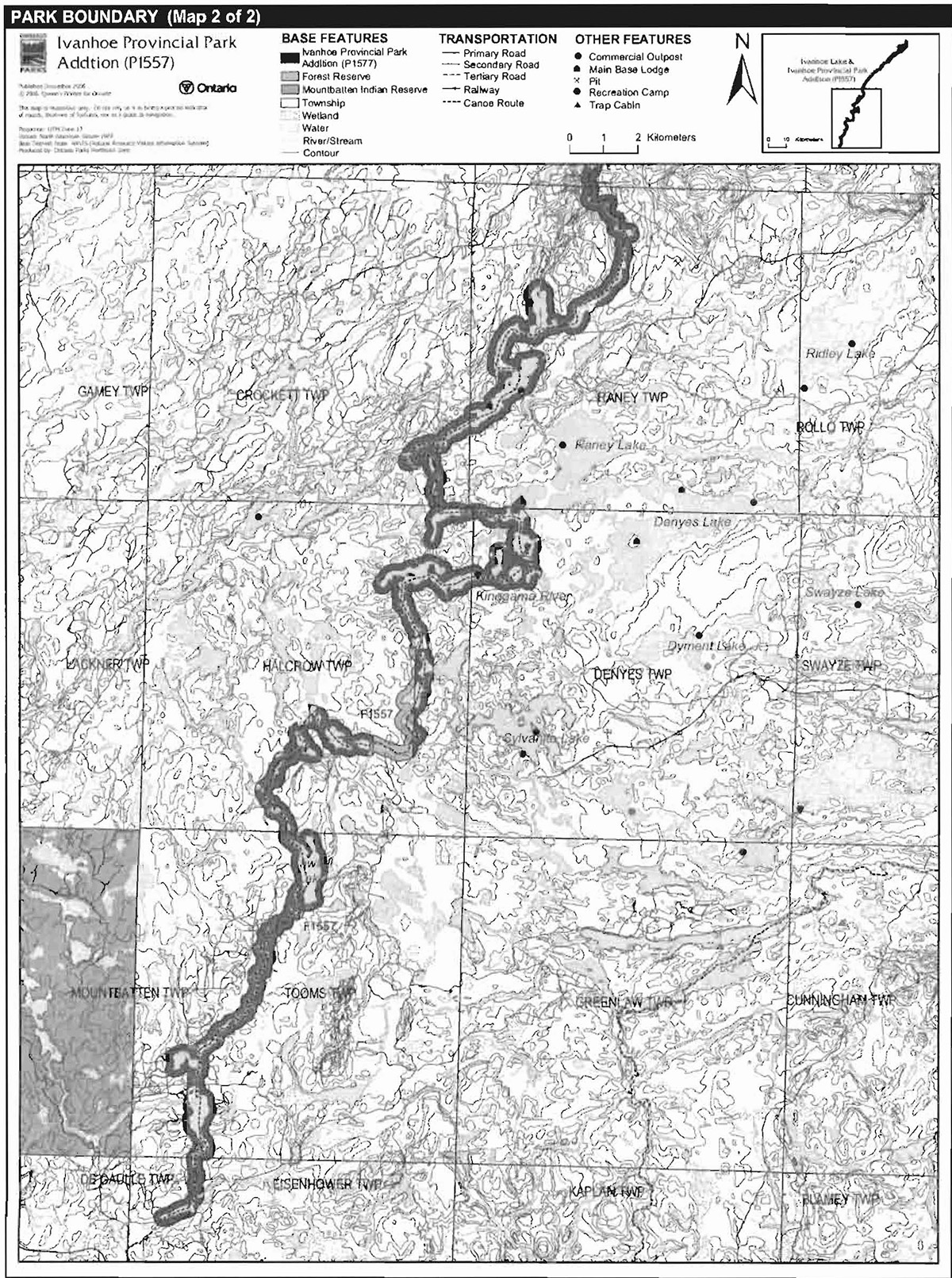
The Ivanhoe Provincial Park Addition is located within five bear management areas (BMA): CP-31-018, CP-31-030, CP-31-031, CP-31-039, and CP-31-038 (Figure 3).
Existing commercial BMAs are permitted to continue. This activity may be subject to conditions identified during future management planning (e.g., the designation of nature reserve zones). New BMA licences will not be permitted (OMNR 2000; 2003).
Commercial bear hunting is not permitted within the original Ivanhoe Provincial Park.
Trapping
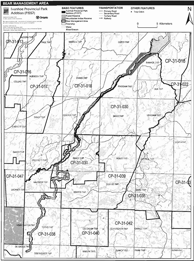
The Ivanhoe Provincial Park Addition is located within seven trap line areas: CP22, CP27, CP31, CP41, CP40, CP53, and CP60 (Figure 4).
Existing commercial fur harvesting operations may continue where the activity has been licensed or permitted since January 1, 1992. New operations, including trap cabins and trails, will not be permitted (OMNR 2000; 2003). Transfers of active trap line licenses are permitted, subject to a review of potential impacts and the normal transfer or renewal conditions that apply.
Trapping is not permitted within the boundaries of the original Ivanhoe Lake Provincial Park. There is one trapline access trail which travels through the original park; this will remain a permitted use for this trail.
Figure 3: Bear management areas
Enlarge figure 3 bear management areas of Ivanhoe Provincial Park
Figure 4: Trap line areas

Enlarge figure 4 trap line areas of Ivanhoe Provincial Park
5.1.3 Industrial resources
There are no licensed aggregate pits (active or inactive) within the park Addition. Aggregate extraction is not permitted in provincial parks (OMNR 1992: 2000).
There are no existing mining claims within the park Addition; numerous claims are adjacent to and abutting the park Addition, including a forest reserve (FR ) designation associated with the park Addition (F1557). The mining and surface rights on all lands within the park have been withdrawn from staking under the Mining Act (1990). Mineral exploration and mining are not permitted in the park.
5.1.4 Access and crossings
Access
Ivanhoe Lake Provincial Park Addition is accessible by primary, secondary, and tertiary roads. There is also canoe access via Ivanhoe Lake and along Ivanhoe River, through the park Addition.
Roads
Highway 101 passes to the northwest of the Ivanhoe Provincial Park Addition. A primary road branches from the highway and travels near to the park Addition approximately half way along the length of the Addition. This primary road supports a large network of secondary and tertiary roads which either end near or extend into the site. On the other side of the river, there is another network of secondary and tertiary roads, but there is no water crossing across the river.
In the northeastern section of the park Addition, adjacent to the original park, there is another extensive network of tertiary roads which provide access to the park and the park Addition.
At the southern end of the Ivanhoe Provincial Park Addition, there is another network of roads on both sides of the Ivanhoe River, as well as a water crossing.
Utility corridors
All public utilities (e.g., gas pipelines, transmission lines, and communications towers) must avoid park lands wherever possible. New utility corridor crossings may be necessary to maintain essential public services (OMNR 2004a).
Any future utility corridors proposed through the park, where park lands are unavoidable, will be reviewed on a case-by-case basis. Protection of park features and values will be priority and all requirements of the Environmental Assessment Act will be met.
Recreational trails
Canoe Routes: The Pishkanogami Canoe Route, an intermediate level route, follows the Ivanhoe River through the park Addition.
Snowmobile Trails: There are no snowmobile trails within the park Addition; however an authorized Ontario Federation of Snowmobiles Association trail (C101F) is located to the north of Ivanhoe Lake Provincial Park Addition (Ontario Federation of Snowmobiling Club 2006).
Other Trails: There are no designated hiking or ATV trails within the park Addition; however, there are approximately 16 portage trails associated with the Pishkanogami River canoe route.
5.1.5 adjacent land management
Forestry
The lands adjacent to the Ivanhoe Lake Provincial Park Addition are in the Pineland and Spanish forest management units (FMU). Both FMUs are managed by Domtar Incorporated in accordance with their respective forest management plan.
Provincial parks
The original Ivanhoe Lake Provincial Park is a natural environment class park which encompasses 1,589 hectares. This park protects significant geomorphologic and ecological features, and provides a range of recreational opportunities.
Other nearby provincial parks include: Wakami Lake, Wenebegon River, and Chapleau Nemegosenda River.
Wakami Lake Provincial Park (P1640e), located to the south of the park Addition, encompasses 12,315 hectares. Situated along the southern fringe of the Canadian Shield, the park is dotted with areas of southern tree species occurring within the encompassing boreal forest. The highlands in the region help to form a watershed between Hudson Bay to the north and the Great Lakes to the south. While it is technically a recreation class park, Wakami Lake is currently managed as a natural environment class park, in recognition of its significant cultural, earth science, and life science features, and its capacity to support a wide range of outdoor recreational activities.
Wenebegon River Provincial Park (P274), located to the southeast of the park Addition, encompasses 16,383 hectares. This 100-kilometre-long waterway class park includes both portions of the Wenebegon River and Wenebegon Lake. The site contains provincially significant peatlands and a canoe route which offers both flat water and white water paddling experiences.
Chapleau-Nemegosenda River Provincial Park (P1546), located to the north of the park Addition, encompasses 12,805 hectares. This waterway class park includes 122 metres on either side of the lower reaches of the two rivers, and a 3.6 hectare area on the western shore of Nemegosenda Lake.
Forest reserve
Forest reserves (FR) are areas where protection of natural heritage and special landscapes is a priority, but some resource use can take place with appropriate conditions. Policies for FRs are similar to the policies for new conservation reserves, except that mining and related activities will be allowed in a forest reserve. Commercial forest harvest, new hydroelectric power development, and peat extraction will not be allowed, but most other resource and recreation uses will be permitted, provided they are consistent with the features and values being protected (OMNR 1999).
The Ivanhoe Provincial Park Addition FR (F1557) that is associated with the Ivanhoe Provincial Park Addition is split into four sections which total 43 hectares. The forest reserve sections abut, or are completely surrounded by, the park boundary and are located in Tooms, Halcrow, Carty, and Ivanhoe townships. As described in the proposed strategy for FRs (OMNR 2005b), the FR designation will be retained and the FR may eventually be added to the park.
General use area
One general use area completely surrounds the Ivanhoe Provincial Park Addition: the General Mixed Use Areas (G1770). This 1,494,486 hectare general use area encompasses areas of significant mining potential and anticipated forest extraction activities. The General Mixed Use Areas contain several roads and access facilities, in addition to six commercial lodges, 79 commercial outpost camps, and 120 cottages. The primary activity throughout much of this area will be an expansion of the forest, mining, and trapping sectors, intermixed with locally-dominant recreation and tourism activities.
5.1.6 Land disposition
New land disposition for the private use of individuals or corporations will not be permitted (OMNR 1992; 2000).
Land use permits, licenses of occupation and unauthorized occupations
Eight land use permits (LUP) have been issued within the Ivanhoe Provincial Park Addition. These permits are issued for seven commercial outposts and one recreation camp in Pinogami, Evans, Hellyer, Raney, and Denyes townships. A main base lodge in Raney Township is situated on private land.
Existing authorized LUPs may be eligible for enhanced tenure but not the purchase of land. Recreational camp LUPs cannot be changed to commercial LUPs unless this is supported during a review as part of park management planning. Enhanced tenure is defined as a possible extension of the term of the LUP for up to 10 years or upgrade in tenure (i.e. LUP to lease) (OMNR 2000a).
Enhanced tenure for an LUP is not guaranteed. Requests for enhanced tenure or to transfer LUPs will be reviewed based upon the following criteria:
- Continued compliance with the conditions of the LUPs
- Current land disposition policies for LUPs
- Consistency with park objectives to sustain values - no effects on heritage values and/or conflict with other uses
- Consistency with Aboriginal land claim negotiations or protocol agreements
- All rents, taxes, fees, rates, or charges are paid and in good standing
An extension in the term of tenure for an existing LUP does not convey a commitment to provide for a change in the type or the standard of existing access to the private recreation camp.
There are no known licenses of occupation or unauthorized occupations within the park Addition.
Patent land
Two parcels of patent land are located within the Ivanhoe Provincial Park Addition. Patent land is not included within the park boundary and, as such, park policy does not apply to this area.
No new patent land will be sold in the Ivanhoe Lake Provincial Park Addition.
Boat caches
There are no authorized boat caches located within this park Addition. Boats are not permitted to be left unattended in the park without written permission from the park superintendent under the authority of the Provincial Parks Act.
5.2 Aquatic ecosystems
Sustaining quality water resources is integral to the protection of park Addition and adjacent lands values. The MOE enforces applicable legislation and regulations for water quality.
5.2.1 Water management
New hydro electric developments are not permitted within the Ivanhoe Lake Provincial Park Additions.
5.2.2 Fisheries management
Fisheries management will complement the maintenance and enhancement of native, self-sustaining fish populations (OMNR 1992).
Sport fishing
Sport fishing is permitted within the park Addition. This activity is governed by legislation and regulations in The Fish and Wildlife Conservation Act (1997) and the Fisheries Act (1985). The Recreational Fishing Regulations Summary contains details on the applicable regulations for this area.
Commercial fishing
There are no commercial fishing operations within the boundary of the Ivanhoe Provincial Park Addition. New operations will not be permitted (OMNR 2000).
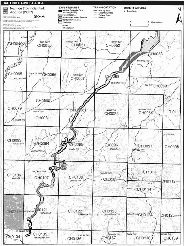
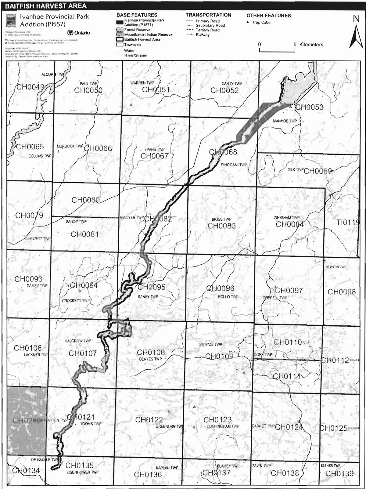
Commercial baitfish harvesting
There are 12 baitfish harvesting areas which overlap the Ivanhoe Provincial Park Addition: CH0053, CH0052, CH0068, CH0067, CH0082, CH0083, CH0095, CH0094, CH0107, CH0108, CH0121, and CH0135 (Figure 5).
Existing commercial baitfish harvesting may continue where the activity has been licensed or permitted since January 1, 1992. This activity may be subject to conditions identified through future park management planning or fisheries management plans. New baitfish licenses will not be permitted (OMNR 2000; 2003).
Fish stocking
The stocking of native fish species may be considered through park management planning, with full public and Aboriginal consultation. Non-native fish species will not be deliberately introduced into park waters (OMNR 1992).
6.0 Operations policies
6.1 Recreation management
6.1.1 Motorized recreation
Motorboats
The use of motorboats is permitted to continue, unless park values are being threatened (OMNR 2004a).
Aircraft
Aircraft landings are permitted within the Ivanhoe Provincial Park Addition (OMNR 1992; 2004a). All aircraft landings are subject to regulation and valid aircraft landing permits issued by the park superintendent under the authority of the Provincial Parks Act.
Snowmobiles
The Ontario Federation of Snowmobiles Association has an authorized trail know as C101F which is located to the north and north-east of the Ivanhoe Provincial Park Addition and travels parallel to the park Addition for most of its length (Ontario Federation of Snowmobiling Club).
There are currently no authorized snowmobile trails within the park. Proposals for new trails may only be considered through future planning with public and Aboriginal consultation (OMNR 2000). Snowmobile use on existing routes for access to private land in-holdings, LUPs, and recreational ice fishing may continue unless park values are threatened.
All-terrain vehicles
There are no authorized ATV trails in the park Addition.
Proposals for new ATV trails may only be considered through future planning with public and Aboriginal consultation (OMNR 2000a). ATV use on existing routes for access to private land inholdings, LLIPs, and recreational ice fishing may continue unless park values are threatened.
The off-road/off-trail use of ATVs will not be permitted within the park additions (OMNR 2004a).
Figure 5: Baitfish harvesting areas
Enlarge figure 5 baitfish harvest areas of Ivanhoe Provincial Park
6.1.2 Non-motorized recreation
Camping
There are no developed campsites within the park Addition; however, several undeveloped campsites along the shoreline. Ontario Parks may assess the condition of existing campsites and will maintain, rehabilitate, or close sites as required. If there is an identified need, new campsites may be considered (OMNR 2004a). Infrastructure will be permitted in order to protect park features and values in response to use, environmental deterioration and environmental protection requirements. Any proposed development in the park Addition must fulfill the requirements of the Environmental Assessment Act.
Hiking
Existing hiking trails may be permitted to continue unless such trails threaten park features and values, create user conflicts or raise safety/liability issues.
If there is an identified need, the development of new hiking trails may be considered. Trail infrastructure to protect park values and features will be permitted. Any proposed development within the park is subject to Environmental Assessment Act requirements.
Canoeing/kayaking
Existing uses may continue, unless park values are threatened (OMNR 2004a). Infrastructure to protect park features and values may be permitted and developed in response to use, environmental deterioration and environmental protection requirements.
6.1.3 Emerging recreational uses
There are emerging recreational uses for which there is limited or no policy to deal with their management (e.g., adventure racing, geocaching). The park superintendent will use legislation, policy, and guidelines which are in place to manage emerging uses in the interim.
6.2 Development
There is no existing park infrastructure located within the Ivanhoe Provincial Park Addition. Infrastructure to protect park features and values may be permitted and developed in response to use, environmental deterioration, and environmental protection requirements. Any proposed development within the park is subject to the Environmental Assessment Act.
6.3 Commercial tourism
There is no existing commercial tourism infrastructure in the Ivanhoe Provincial Park Addition. New commercial tourism facilities may be considered where they would be consistent with park policy (OMNR 2004a). Any development must meet the requirements of the Environmental Assessment Act. Existing authorized tourism facilities continue subject to management prescriptions determined through management planning. Any development must meet the requirements of the Environmental Assessment Act. Existing authorized tourism facilities may continue subject to management prescriptions determined through management planning. Existing tourism facilities (e.g., LUPs, leases) may be eligible for enhanced tenure, and decisions will be made in management planning.
7.0 Cultural resources
An assessment of the cultural resources specific to the Ivanhoe Lake Provincial Park Addition has not been completed; however, the management of any cultural values within this park will be directed toward protection and heritage appreciation (OMNR 1992).
8.0 Heritage education
Natural heritage education (NHE), or visitor services, will be managed in accordance with the park management plan. A NHE plan will be prepared in keeping with the direction provided in the management plan to manage education activities. These plans will provide specific operational guidelines on how to carry out visitor services programs.
The park addition and area themes will be highlighted primarily through self-use information and facilities. The main theme associated with the Ivanhoe Provincial Park Addition is "deglaciation history."
Literature and other supporting information may be developed to describe the park in the context of Ontario’s provincial park system. Boundary limits, significant heritage features and permitted uses of the natural environment class park may be included in park literature.
Prospective park visitors may be informed about the sensitivity and significance of park values through park literature.
9.0 Research
Scientific research by qualified individuals which contributes to the knowledge of natural or cultural history, or to environmental or recreational management, may be encouraged in the park. Ontario Parks will encourage institutions, such as universities, to undertake research projects.
All research programs will require the approval of Ontario Parks and are subject to park policy and other applicable legislation. Any materials removed from the park will remain the property of Ontario Parks.
Approved research activities and facilities will be compatible with the park’s protection objective. Any site which is affected by research will be rehabilitated as closely as possible to its original state. Environmental Assessment Act requirements will apply.
10.0 References
Duba, D., and E. Frey, 2002, P1557 Ivanhoe Lake Provincial Park Addition: Earth Science Inventory.
Morris, E. R., 2004. Ivanhoe Lake Provincial Park Addition (P1557): Life Science Checksheet.
Environmental Assessment Act, 1990.
Fish and Wildlife Conservation Act, 1997.
Fisheries Act, 1985.
Migratory Birds Convention Act, 1994.
Morris, E. R., 2004. Ivanhoe Lake Provincial Park Addition (P1557): Life Science Checksheet.
Ontario Federation of Snowmobiles Club, 2006.
Ontario Ministry of Natural Resources, 1974. A Topical Organization of Ontario History. Historic Sites Branch Division of Parks.
Ontario Ministry of Natural Resources, 1986. Ivanhoe Lake Provincial Park Management Plan.
Ontario Ministry of Natural Resources, 1992. Ontario Provincial Parks Planning and Management Policies, 1992 Update.
Ontario Ministry of Natural Resources, 1999. Ontario’s Living Legacy Land Use Strategy, Queen’s Printer for Ontario.
Ontario Ministry of Natural Resources, 2000. Ontario Provincial Park Policy as Amended by the Ontario Living Legacy Land Use Strategy.
Ontario Ministry of Natural Resources, 2004a. Crown Land Use Policy Atlas.
Ontario Ministry of Natural Resources, 2004b. Forest Fire Management Strategy for Ontario.
Ontario Ministry of Natural Resources, 2005a. A Class Environmental Assessment for Provincial Parks and Conservation Reserves.
Ontario Ministry of Natural Resources, 2005b. Summary of Proposed "Disentanglement" Strategies for Recommended Protected Areas and Pre-existing Mining Lands.
Provincial Parks Act, 1990.
Appendix A: Background information
| Name | Ivanhoe Provincial Park Addition (P1557) |
|---|---|
| Classification | Natural Environment |
| Ecoregion/Ecodistric | 3E-5 (Smokey Falls) |
| OMNR Administrative Region / District | North East Region – Chapleau |
| Total Area (ha) of Addition | 6,100 |
| Regulation Date and number for original park | 1980 (O. Reg. 821/80) |
| Regulation Date and number for the Addition | O. Reg. 180/05 |
Representation
Earth science:
The Ivanhoe Provincial Park Addition includes the Ivanhoe and Kinogama rivers flowing into Ivanhoe Lake Provincial Park. The dominant rocks are granodiorite to tonalite and mafic migmatite of the Ivanhoe Lake Cataclastic Zone and granodiorite of the western Abitibi Subprovince, in the Archean Superior Province (Duba and Frey 2002).
The Superior Province is the product of southward tectonic accretion of elongated orogenic terranes (subprovinces) of distinctive structure and volcanic, sedimentary and plutonic rock assemblages. Its early to late Archean age, circa 3400 to 2500 million years ago, spans an extensive portion of the beginnings of stabilization of the earth’s crust. Today the rocks of the region display the eroded roots of deformed mountain ranges and large intrusive masses, common products of these events (Duba and Frey).
Life science:
The main forests of the Addition include intolerant hardwoods and mixedwood (∼2050 ha), Jack pine and upland conifers (∼1350 ha), and lowland coniferous forests (∼890 ha). Only a few, very small occurrences (<5 ha) of red pine (Figure 20), mixed tolerant hardwoods (∼0.5 ha), and lowland hardwood bottomlands (∼0.5 ha) were observed. intolerant hardwood and mixedwood forest representations include stands dominated by young to mature white birch (∼275 ha), mature to old-growth balsam fir {∼95 ha), mature to old-growth white spruce (∼110 ha), or young to old-growth trembling aspen (∼930 ha). Stands with no clear dominant species, young to old-growth undifferentiated mixedwoods, are also abundant (∼640 ha). Jack pine and upland conifer representations included young to mature Jack pine dominated forests (∼810 ha), mature Jack pine-black spruce uplands (∼160 ha), and young to mature mixed Jack pine uplands (∼510 ha) (Morris 2004).
Cultural resources:
An investigation and analysis of the cultural resources specific to Ivanhoe Lake Provincial Park Addition has not been completed at this time.
Recreation and tourism:
The Ivanhoe Lake Provincial Park Additions dominant recreational feature is the Ivanhoe River, this river is diverse in nature with various sized channels, lakes and wetlands. These recreational features support a large variety of recreational activities. There is even an existing canoe route, which can be accessed via a variety of means such as the CPR line south of the river, or through various logging roads adjacent to the river including one river crossing and also by floatplane; there is also a series of rapids which may be navigable by canoe or kayak. Open areas in the forest of Ivanhoe Lake Provincial Park Additions afford natural and man made wildlife viewing opportunities. Also, given the size of the Ivanhoe River motorboat use is a popular activities and as such this activity opens up a means to pursue other recreational activities such as hunting and fishing.
Inventories
| Survey Level | Earth Science | Life Science | Cultural | Recreational | Other |
|---|---|---|---|---|---|
| Reconnaissance | D.Duba and E. Frey, 2002 | E.R. Morris, 2002 | Required | Required | Required |
Footnotes
- footnote[1] Back to paragraph Transfers include situations where a license is surrendered with a request that it be immediately reissued to another individual or organization that is assuming an existing operation . Trap cabins are considered part of a trapline and would be transferred with the trapline for the purposes of trapping. If a trapline license is revoked or surrendered, all portions of the registered line within the park will be rescinded from the legal description of the trap line (OMNR 2003).