James N. Allan Provincial Park Management Statement
This document provides policy direction for the protection, development and management of James N. Allan Provincial Park and its resources.
Interim Management Statement
March, 1985
This Interim Management Statement will provide interim direction for the management of James N. Allan Candidate Provincial Park until a comprehensive Park Management Plan is prepared.
This statement will provide the basis for the subsequent preparation of the Park Management Plan.
I am pleased to approve this Interim Management Statement for James N. Allan Candidate Provincial Park.
Signed by:
M. Fordyce
Regional Director
Central Region
Background information
| Name: | James N. Allan Candidate Provincial Park |
|---|---|
| Proposed Class: | Recreation |
| M.N.R. District: | Niagara |
| M.N.R. Region: | Central |
| Total Area (ha): | 113 ha |
| Land Water: | |
| Site Region: | 7 |
| Site District: | 7-2 |
| Date in Regulation: | 1986 |
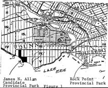
Regional setting map
Targets
1 Life science representation
| Site type/landscape unit | Species/communities |
|---|---|
| Southern Deciduous Forest Region (Hills) Niagara Section of the Deciduoud Forest Region (Rowe) Haldimand Clay Plain (flat terrain with extensive areas of swampy lowland) Lake Erie Coast Environmental Subregion |
- Beach - grasses, horsetail, wild grape, hedge - bindweed - Marsh - arrowhead, cattail, grasses - Cleared Field - Deciduous Swamp Forest - red ash, American elm, hop hornbeam, ironwood - Deciduous Upland Forest - red oak, white and red ash, shagbark, hickory, basswood - Old Field - bluegrass, timothy, hawthorn, red ash, American elm |
2 Earth science representation
| Geological theme | Feature |
|---|---|
| Middle Devonian Port Huron Stadial Holocene |
- Edgecliff member (limestone) - sands and silts of glacial Lake Warren (Halton Till) - tombolo (sand bar connecting an island to mainland) |
3 Cultural resource representation
| Theme | Theme segment |
|---|---|
4 Recreation opportunities
| Day use | Car camping | Wilderness/back country |
|---|---|---|
| Niagara D.L.U.G picnic tables - 330 metred beach - 1,100 |
Inventories
| Level/ type | Earth science | Life science | Cultural | Recreational | Other |
|---|---|---|---|---|---|
| reconnaissance | 1977 Woerns Earth Science Inventory Checklist |
1980, Macdonal Life Science Inventory Checklist |
1984 J. Belan and S. Moreau Niagara District Land Use Guidelines |
||
| detailed | 1984, Gould A Reconnaissance Biological Inventory of James N. Allan Park Reserve |
||||
| required |
Management guidelines
I Land tenure
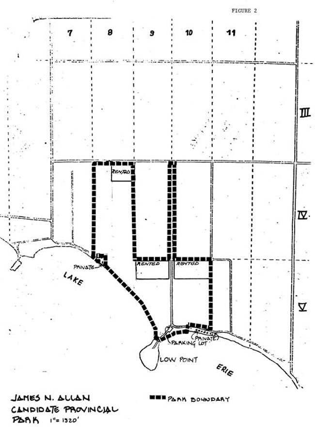
Approximately 24 hectares in Lots 9 and 10 of Concession V, are rented out for agricultural purposes (corn and soybeans). This use of parklands will be periodically reviewed.
The main road allowance between Lots 9 and 10, Concession IV and V is owned and maintained by the Ministry. The cottagers along the lakeshore have right-of-way over this road.
II Land acquisition/disposal
One cottage lot (one-quarter hectare) surrounded by parkland remains to be purchased along the western coast of the park (Lot 8, Concession V). At the time of writing this plan, negotiations are underway to secure this lot.
Although not a high priority, if funds become available and priorities permit, two additional areas are worth considering for acquisition, namely: (1) the peninsula of land jutting into the lake (Low Point) and (2) waterfront cottages fronting along the eastern side of the park.
III Existing/proposed development
A gravel road, approximately 1.6 km long, with ditching along approximately 75% of its length, provides access into the park for park users and access to the cottages. An eastern branch of this road, still on Ministry property, provides access to the cottages on the park’s eastern side. A small parking lot is located adjacent to the beach.
A concrete pad, the remnant of a past building, is located on the park’s west side.
The Ministry maintains all of the fences along the park’s boundary.
Recommendations:
Ditching on both sides of the main road, along its entire length should be completed.
The parking lot at the beach is too small and because of its location, is continually being sanded in. This increases the maintenance of the lot substantially. Consideration should be given to relocating the lot to the north side of the road.
The draining ditch outlet into Lake Erie will be monitored and cleaned out as required.
Security and garbage pickup will be performed on a regular basis from Rock Point Provincial Park.
Map: James N. Allan Candidate Provincial Park, Park Boundary
At some point in the future, if deemed necessary, signs may be posted indicating land ownership and park status.
IV Recreation activities
Common recreation activities that occur here include: swimming, sunbathing, walking, boating and bird watching. With the exception of hunting, existing recreation activities will be allowed to continue. Hunting will not be permitted after 1986.
To control use, the site has been posted as day use only, open from 6 a.m. - 9 p.m. The local Ontario Provincial Police will be made aware of the existence and status.
The Niagara District Land Use Guidelines recommend the following:
Picnicking …………. 79,300 opportunities ……. 330 tables
Swimming ………… 208,500 opportunities …..1,100 metres of beach
Actual number of facilities and opportunities to be provided will be determined in the future by the James N. Allan Provincial Park Management Plan.
V Natural Resources
High water levels and the natural dynamics of Lake Erie have contributed to loss of beach, bluff and vegetation through erosion. Any new development will be kept well back from the shoreline.
Extensive reforestation has occurred. Since the survival rate is low, replanting will occur as funds become available. Funding must also be available for minimum maintenance of new plantings, especially during the first few years.
A 2-ha parcel is currently planted as a hybrid poplar research plot, managed by district Forestry staff.
Agricultural use can continue on parkland until such time as lands are needed for other purposes.
The existing woodlots are at an age and state where they require very little management in the near future.
Commercial trapping will be not permitted. Trapping as a management technique may occur where it is necessary to deal with nuisance animals.
VI Marketing
Even though this park will be regulated as a provincial park in 1986, there are no plans in the near future to promote its use, apart from general information provided to the public regarding Public Land holdings.
Bibliography
Gould, J., 1984. A Reconnaissance Biological Inventory of James N. Allan Park Reserve.
Ministry of Natural Resources, 1972. James N. Allan Park Reserve, Data for Master Planning.
Ministry of Natural Resources, 1976. Interim Forest Management Plan for James N. Allan Park Reserve.
Ministry of Natural Resources, 1977. An Evaluation of Earth Science Features in the Parks, Park Reserves and Special Areas of Central and Southwestern Regions.
Ministry of Natural Resources, 1978. Ontario Provincial Parks Planning and Management Policies.
Ministry of Natural Resources, 1979. First Draft Provincial Parks Systems Plan.
Ministry of Natural Resources, Life Science Features of the Haldimand Clay Plain Physiographic Region.
Ministry of Natural Resources, 1983. Niagara District Land Use Guidelines.
Ministry of Natural Resources, (1983-84). James N. Allan Park Reserve Interim Management Guidelines.
File: General File 6609-05-26 (Central Region)