James N. Allan Provincial Park Management Statement: Amendment
This amendment provides revised direction in the statement to restore or naturalize disturbed lands, including lands previously used for agriculture, in order to enhance ecological integrity.
Examination and adjustment of management direction
| Approval Date | Examination or Type of Adjustment | Examination Outcome (where applicable) | Comment |
|---|---|---|---|
| March, 1985 | Management Plan | N/A | Interim Management Statement signed by Michelle Fordyce |
| July 19, 2012 | Examination | Re-write | |
| February 24, 2016 | Administrative Update | N/A | Update existing Management Direction to reflect current legislation and policy (re-write pending) |
| May 4, 2016 | Amendment | N/A | Amend existing management direction to enable restoration (in progress) (re-write pending). |
Amendment approval statement
Dear Sir or Madam:
I am pleased to approve this amendment to the management plan for James N. Allan Provincial Park. The amendment provides revised direction in the plan to restore or naturalize disturbed lands, including lands previously used for agriculture, in order to enhance ecological integrity.
I would like to express my appreciation to all those who participated in the planning process.
Sincerely,
Signed by Bruce Bateman
Director, Ontario Parks
Date, May 2, 2017
Approval statement
March, 1985
This Interim Management Statement will provide interim direction for the management of James N. Allen Candidate Provincial Park until a comprehensive Park Management Plan has been prepared.
This statement will provide the basis for subsequent preparation of the Park Management Plan.
I am pleased to approve this Interim Management Statement for James N. Allen Provincial Park.
Signed by M. Fordyce,
Regional Director
Central Region
Background information
Name: James N. Allan Provincial Park
Class: Recreation
MNRF Parks Zone: Southwest
MNRF Region: Southern
Total Area (ha): 117
Ecodistrict: 7E-5
Date in regulation: 1986 targets
1. Life science representation
| Site Type / Landscape Unit | Feature |
|---|---|
| Southern Deciduous Forest Region (Hills) | beach grasses, horsetail, wild grape, hedge-bindweed |
| Niagara Section of the Deciduous Forest Region (Rowe) | deciduous upland forest, red oak, white and red ash, shagbark hickory, basswood |
| Haldimand Clay Plain (flat terrain with extensive areas of swampy lowland) | deciduous swamp forest, red ash, American elm, hop hornbeam, ironwood, arrowhead, cattail, grasses |
| Lake Erie Coast Environmental Subregion | Old field, bluegrass, timothy, hawthorn, red ash, American elm |
2. Earth science representation
| Geologic Theme | Feature |
|---|---|
| Middle Devonian | Edgecliff number (limestone) |
| Port Huron Stadial | Sands and silts of glacial Lake Warren (Halton Till) |
| Holocene | Tombolo (sand bar connecting an Island to mainland) |
3. Cultural resources representation
| Theme | Theme Segment |
|---|---|
| 0 | 0 |
4. Recreational opportunities
| Day Use | Car Camping | Wilderness / Backcountry |
|---|---|---|
| Niagara DLUG picnic tables 330, beach 1100 | 0 | 0 |
Inventories
| Inventory Type | Earth Science | Life Science | Cultural | Recreational | Other |
|---|---|---|---|---|---|
| Reconnaissance | 1977 Woerns, Earth Science Inventory Checklist | 1880 Macdonald, Life Science Inventory Checklist | - | 1984 J. Belan and S. Moreau, Niagara District Land Use Guidelines | - |
| Detailed | - | 1984 Gould, A Reconnaissance Biological Inventory of James N. Allan Park Reserve | - | - | - |
| Required | - | - | - | - | - |
Figure 1: Regional setting map
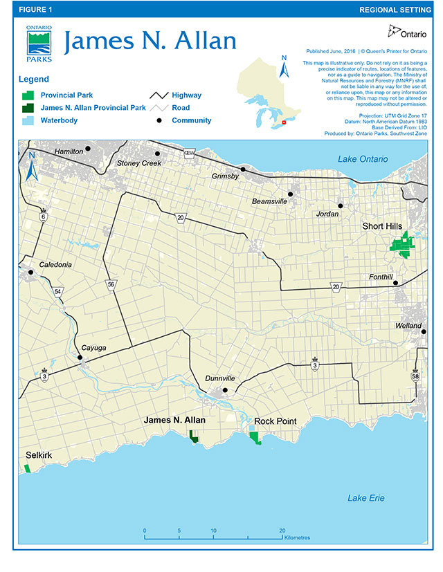
Enlarge figure 1: Regional setting map
Figure 2: Park boundary and existing development map
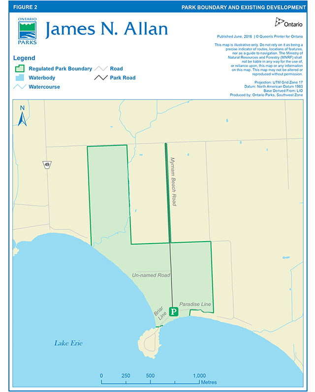
Enlarge figure 2: Park boundary and existing development map
Context
1. Provincial Parks and Conservation Reserves Act
The Provincial Parks and Conservation Reserves Act, 2006 (PPCRA) requires that a Management Direction is approved for each protected area in Ontario. This document fulfils this requirement, and provides direction for managing the provincial park.
The PPCRA has two principles that guide all aspects of planning and management of Ontario’s system of provincial parks and conservation reserves:
- Maintenance of ecological integrity shall be the first priority and the restoration of ecological integrity shall be considered.
- Opportunities for consultation shall be provided. 2006, c. 12, s. 3.
The PPCRA also outlines four objectives for establishing and managing provincial parks:
- To permanently protect representative ecosystems, biodiversity and provincially significant elements of Ontario’s natural and cultural heritage and to manage these areas to ensure that ecological integrity is maintained.
- To provide opportunities for ecologically sustainable recreation opportunities and encourage associated economic benefits.
- To provide opportunities for residents of Ontario and visitors to increase their knowledge and appreciation of Ontario’s natural and cultural heritage.
- To facilitate scientific research and to provide points of reference to support monitoring of ecological change on the broader landscape. 2006, c. 12, s. 2 (1).
2. Management context
Management of this park will be consistent with all relevant legislation and provincial policies, including the four provincial park objectives and guiding principles of the PPCRA. Management of the park will also be consistent with the Endangered Species Act, 2007 (ESA), including the protection of Species at Risk.
Management guidelines
1. Land tenure
Agricultural land use permits have been phased out in accordance with park policy.
The main road allowance between Lots 9 and 10, Concession IV and V is owned and maintained by the Ministry. The cottagers along the lakeshore have right of way over this road.
2. Land acquisition and disposition
One cottage lot (one quarter hectare) surrounded by parkland has been purchased along the western coast of the park (Lot 8, Concession V). This lot has been regulated as part of the park (Figures 1 and 2).
Although not a high priority, if funds become available and priorities permit, two additional areas are worth considering for acquisition, namely: (1) the peninsula of land jutting into the lake (Low Point) and (2) waterfront cottages fronting along the eastern side of the park.
Ontario Parks will support, in principle, the acquisition of property for addition to James N. Allan Provincial Park, if the acquisition will enhance the values or management of the park. Acquisition or securement will be subject to funding and willingness of the owners to sell or lease their properties or enter into a conservation easement. Land securement priorities for James N. Allan Provincial Park are focused on lands adjacent and with similar natural and cultural values.
3. Existing development
A gravel road, approximately 1.6 km long, with ditching along approximately 75 percent of its length provides access into the park for park users and access to the cottages. An eastern branch of this road still on provincially owned property provides access to the cottages on the park’s eastern side. A small parking lot is located adjacent to the beach.
A concrete pad, the remnant of a past building is located on the park’s west side The MNRF, Ontario Parks maintains all of the fences along the park’s boundary.
4. Proposed development
Ditching on both sides of the main road, along its entire length should be completed.
The parking lot at the beach is too small and because of its location, is continually being sanded in. This increases the maintenance of the lot substantially. For these reasons, the lot has been relocated to the north side of the road.
The draining ditch outlet into Lake Erie will be monitored and cleaned out as required.
Security and garbage pickup will be performed on a regular basis from Rock Point Provincial Park.
At some point in the future, if deemed necessary, signs may be posted indicating land ownership and park status.
5. Ecologically sustainable recreation activities
Common recreation activities that occur here include: swimming, sunbathing, walking, boating and bird watching. Existing recreation activities will be allowed to continue. Hunting is not permitted in accordance with the Fish and Wildlife Conservation Act.
To control use, the site has been posted as day use only, open from 6 a.m. - 9 p.m. The local Ontario Provincial Police will be made aware of the status of the park.
Additional facilities and opportunities to be provided will be determined in the future by a James N. Allan Provincial Park management planning process.
6. Natural resource management
High water levels and the natural dynamics of Lake Erie have contributed to loss of beach, bluff and vegetation through erosion. Any new development will be kept well back from the shoreline.
Extensive reforestation has occurred. Since the survival rate is low, replanting will occur as funds become available. Funding must also be available for minimum maintenance of new plantings, especially during the first few years.
Disturbed lands including those currently or formerly in agricultural use will be restored or naturalized. The primary goal of restoration and naturalization will be to enhance the park’s ecological integrity by accelerating succession from disturbed areas such as agriculture or old field to locally representative vegetation types, while minimizing colonization of noxious weeds or alien invasive species. Restoration and naturalization approaches could include passive or indirect restoration, seeding and planting, wetland improvement, progressive retirement and invasive species control. Site specific restoration and naturalization activities will be determined based on current site conditions, available resources, funding and partnership opportunities, and will be subject to evaluation under the Class EA-PPCR.
A 2-ha parcel was planted as a hybrid poplar research plot, managed by district Forestry staff. It is no longer managed as a research site. It has been allowed to succeed naturally.
The existing woodlots are at an age and state where they require very little management in the near future.
Commercial trapping will be not permitted. Trapping as a management technique may occur where it is necessary to deal with nuisance animals.
7. Cultural heritage resources management
Cultural heritage resources that may be impacted by any park projects and activities shall be identified and managed (i.e., protected, maintained, used and disposed of) in accordance with the Standards and Guidelines for Conservation of Provincial Heritage Properties (Ontario Heritage Act). Staff will also consult MNRF's Technical Guideline for Cultural Heritage Resources for Projects Planned Under the Class Environmental Assessment for Resource Stewardship and Facility Development and the Class Environmental Assessment for Provincial Parks and Conservation Reserves (2006).
8. Marketing
Even though this park will be regulated as a provincial park in 1986, there are no plans in the near future to promote its use, apart from general information provided to the public regarding Public Land holdings.
If required, marketing for James N. Allan Provincial Park will occur through Ontario Parks' corporate marketing strategies and activities.
9. Research
Research activities require authorization issued under the PPCRA, consistent with research authorization policies for Provincial Parks and Conservation Reserves. Research is subject to development and management policies associated with the park’s classification, unless special permission is given. Research must meet all requirements under applicable provincial and federal legislation, and may require additional permits or approval (e.g., MNRF Wildlife Scientific Collector authorization or ESA permits).
The MNRF will encourage scientific research by qualified individuals contributing to the knowledge of natural and cultural history and to environmental management. Ontario Parks will review proposed research to ensure adequate consideration of potential impacts on protected area resources, features, staff and visitors.
References
Gould, J., 1984. A Reconnaissance Biological Inventory of James N. Allan Park Reserve.
Ministry of Natural Resources, 1972. James N. Allan Park Reserve, Data for Master Planning.
Ministry of Natural Resources, 1976. Interim Forest Management Plan for James N. Allan Park Reserve.
Ministry of Natural Resources, 1977. An Evaluation of Earth Science Features in the Parks, Park Reserves and Special Areas of Central and Southwestern Regions.
Ministry of Natural Resources, 1978. Ontario Provincial Parks Planning and Management Policies.
Ministry of Natural Resources, 1979. First Draft Provincial Parks Systems Plan.
Ministry of Natural Resources, Life Science Features of the Haldimand Clay Plain Physiographic Region.
Ministry of Natural Resources, 1983. Niagara District Land Use Guidelines.
Ministry of Natural Resources, (1983-84). James N. Allan Park Reserve Interim Management Guidelines.
Ontario Ministry of Natural Resources. A Class Environmental Assessment for Provincial Parks and Conservation Reserves, 2005.
Ontario Ministry of Natural Resources. 2006. A Technical Guideline for Cultural Heritage Resources for Projects Planned Under the Class Environmental Assessment for MNR Resource Stewardship and Facility Development Projects and the Class Environmental Assessment for Provincial Parks and Conservation Reserves.
Ontario Ministry of Natural Resources. 2010. Species at Risk in Ontario List.
Ontario Ministry of Natural Resources. 2011. Ontario’s Crown Land Use Policy Atlas.
Ontario Ministry of Natural Resources. 2011. Our Sustainable Future: A Renewed Call to Action – Ministry of Natural Resources Strategic Directions. Peterborough.
Ontario Ministry of Natural Resources. 2012. Biodiversity: It’s In Our Nature. Ontario Government Plan to Conserve Biodiversity, 2012-2020. Queen’s Printer for Ontario. Toronto, ON. 42 pp.
Ontario Ministry of Natural Resources. 2014. Ontario Protected Areas Planning Manual: 2014 Edition. Peterborough. Queens Printer for Ontario. 33 pp File: General File 6609-05-26 (Central Region)
Footnotes
- footnote[i] Back to paragraph In Ontario, the Ministry of Natural Resources and Forestry delineates natural regions to enable landscape planning and monitoring. Ontario is divided into 71 Ecodistricts (formerly known as ecological site districts) based on landforms and biological productivity. For protected area system planning purposes, protected area establishment is designed to be representative of the Ecodistricts in which they are found.
- footnote[ii] Back to paragraph Species at risk are defined as those species listed on the Species at Risk in Ontario (SARO) List regulation. In addition, Ontario Parks manages protected areas for the benefit of provincially significant species (S1-S3) as defined by Ontario’s Natural Heritage Information Centre (NHIC).