Kahshe Lake Barrens Conservation Reserve Management Statement
This document provides policy direction for the protection, development and management of the Kahshe Lake Barrens Conservation Reserve and its resources.
Statement of Conservation Interest
Ministry of Natural Resources
Parry Sound District
Prepared with the assistance of:
Meteek & Company
Huntsville, Ontario
March 2005
Approval statement
We are pleased to approve this Statement of Conservation Interest for Kahshe Lake Barrens Conservation Reserve (C38).
Kahshe Lake Barrens Conservation Reserve, situated in Morrison Ward in the Town of Gravenhurst in the District Municipality of Muskoka, occupies 3,169 hectares of Crown land south of Kahshe Lake. The conservation reserve lies within the Hills' (1959) ecological Site District 5E-8. It is a very large, undisturbed series of bedrock barrens interspersed with wetland areas and treed uplands. The area is characterized by its thin soils except for some accumulations in minor depressions and between the parallel ridges of bedrock. The site provides habitat for more than 500 species of flowering plants as well as about one hundred known species of birds, mammals, reptiles, amphibians and insects.
Kahshe Lake Barrens Conservation Reserve is one of 378 new protected areas approved through Ontario’s Living Legacy, a land use strategy aimed, in part, at completing Ontario’s system of parks and protected areas. Kahshe Lake Barrens Conservation Reserve is situated close to two other new protected areas, Jevins and Silver Lake Conservation Reserve (C37), located to the north, and Queen Elizabeth II Wildlands Provincial Park (P34), encompassing Crown lands a short distance to the east and southeast.
During the "Lands for Life" planning process, the public was widely consulted and provided valuable input into what became Ontario’s Living Legacy Land Use Strategy. Additional public consultation related to Kahshe Lake Barrens Conservation Reserve occurred in September 2001. Comments received during that time, and during consultation related to the formal Public Lands Act regulation of the boundaries of this conservation reserve, were generally supportive of the protection of this area. Stakeholders who provided comment during the earlier consultation for this site were subsequently consulted regarding the draft Statement of Conservation Interest and any comments were considered in the finalization of this document.
This Statement of Conservation Interest provides guidance for the management of the conservation reserve and provides the basis for the ongoing monitoring of activities. More detailed direction is not anticipated at this time. Should more complex resource management or conservation issues arise or significant facility development be considered, then a detailed Resource Management Plan will be prepared with full public consultation.
Kahshe Lake Barrens Conservation Reserve is managed under the direction of the District Manager and the Bracebridge Area Supervisor of the Ministry of Natural Resources, Parry Sound District.
Approved by:
R. Griffiths
District Manager
Parry Sound District
Approved by:
Ron Running
Regional Director
Southern Region
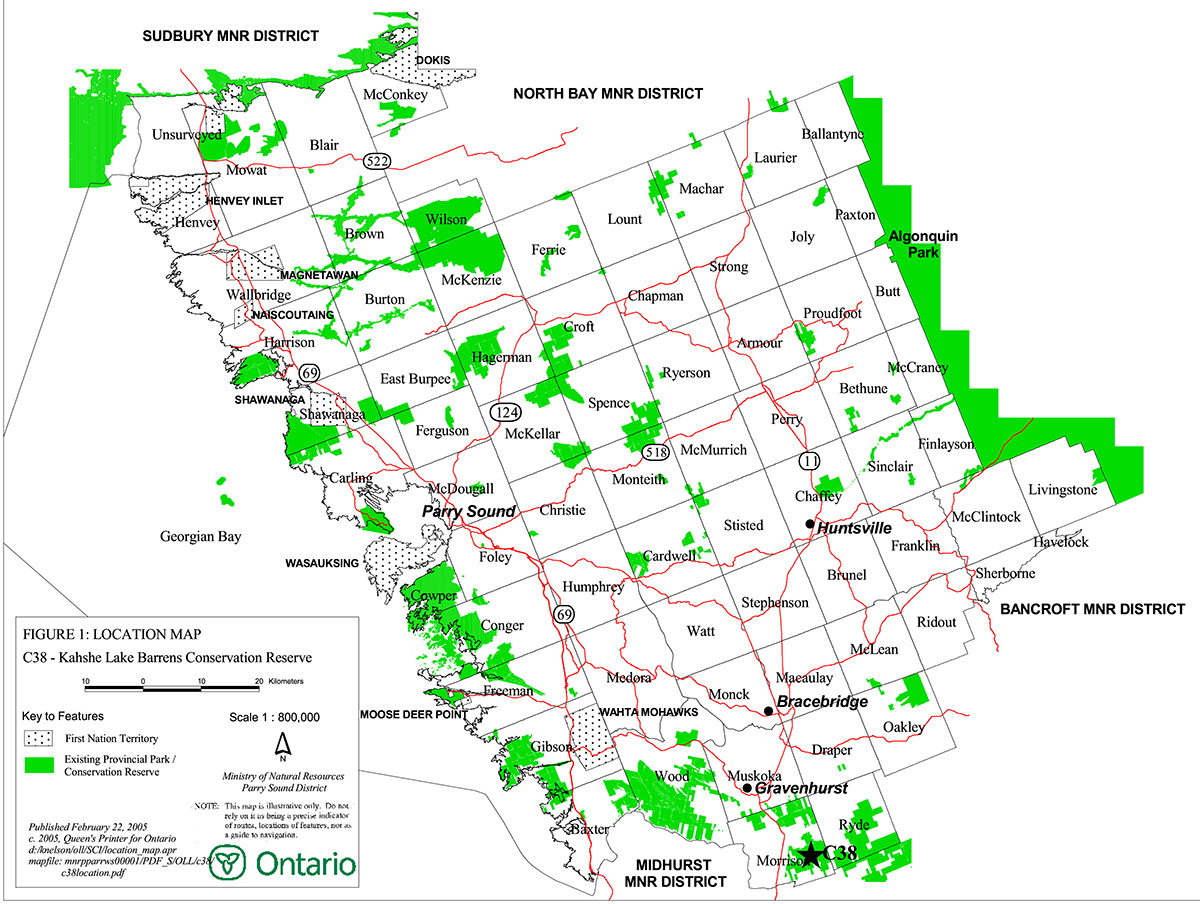
Figure 1: Location of Kahshe Lake Barrens Conservation Reserve (C38)

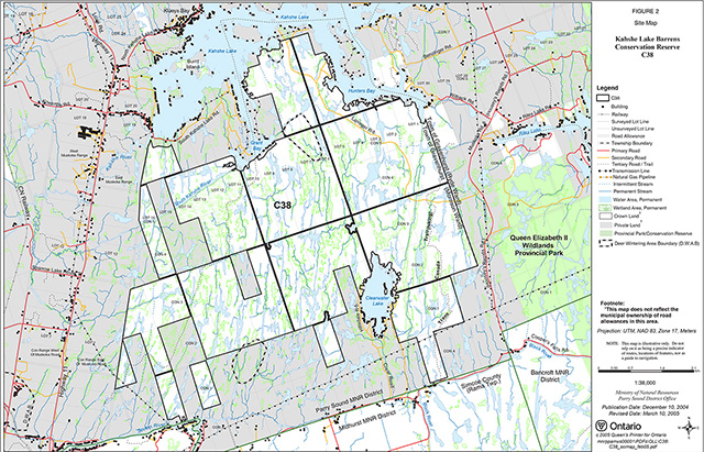
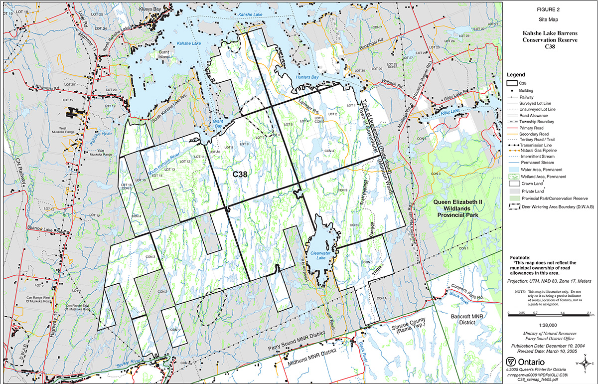
Figure 2: Site Map – Kahshe Lake Barrens Conservation Reserve (C38)
1.0 Introduction
Ontario’s Living Legacy, the result of an extensive planning process that began in early 1997, culminated in the approval in July 1999 of a Land Use Strategy that identifies the intended strategic direction for Crown land in central and northern Ontario, including the completion of Ontario’s system of parks and protected areas. This process, which included public consultation, resulted in the recommendation for regulation of 378 new protected areas, including Kahshe Lake Barrens Conservation Reserve (C38).
Kahshe Lake Barrens Conservation Reserve consists of 3,169 hectares of Crown land, located about 12 kilometres southeast of the town centre of Gravenhurst, and to the east of Highway 11. Muskoka Road 6 lies to the east of the eastern boundary. Kahshe Lake, a large heavily-cottaged warm-water lake with many bays and inlets, lies along part of the northern boundary. Clearwater Lake, also supporting cottage development, lies along its south boundary and Highway 11 is situated to the west of the conservation reserve. Kahshe Lake Barrens Conservation Reserve is located between Kahshe Lake and the southern boundary of Morrison Ward in the Town of Gravenhurst in the District Municipality of Muskoka. The conservation reserve consists entirely of Crown lands. It is surrounded by private lands and there are isolated pockets of private land interspersed within the conservation reserve.
Kahshe Lake Barrens Conservation Reserve has long been known to have natural values. Dan Brunton (1993) identified this site as a candidate Area of Natural and Scientific Interest (ANSI); he referred to it as a potential "provincially significant wetland and upland complex". The Candidate ANSI reference has no official status, but was important for identifying potential significance. The Muskoka Heritage Areas Program, a program of the District Municipality of Muskoka to identify natural heritage areas of significance, inventoried this site in 1991. The site was municipally identified as a Muskoka Heritage Area, meaning that it met criteria as a good example of the District’s natural and cultural heritage (Reid and Bergsma 1994).
The Crown land portions of Burnt Island in Kahshe Lake are not a part of this site. However, there may be significant populations of Atlantic Coastal Plain flora on these lands. MNR will carry out an assessment of the Crown land portions of Burnt Island in Kahshe Lake, to assist in determining whether or not MNR should consider adding these lands to the CR at a later date. Any consideration of adding these lands would include a public consultation process.
Conservation reserves are established under the authority of the Public Lands Act, Ontario Regulation 805/94. Regulation of Kahshe Lake Barrens Conservation Reserve is in progress and expected in 2005.
A Statement of Conservation Interest is prepared under the direction of Procedural Guideline A – Resource Management Planning (PL. Procedure 3.03.05). The purpose of this Statement of Conservation Interest is to identify and describe the values of Kahshe Lake Barrens Conservation Reserve. The Statement of Conservation Interest also outlines the activities that currently occur within the conservation reserve and provides guidelines for the management of current and future activities in the context of protecting the natural, recreational and cultural values.
1.1 Background information:
| Name | Kahshe Lake Barrens Conservation Reserve (C38) |
|---|---|
| Site Region / District | Georgian Bay Site Region, Site District 5E-8 |
| OMNR Administrative Region / District / Area | Southern Region/ Parry Sound District/ Bracebridge Area |
| Total Area (ha) | 3,169 hectares |
| Regulation Date | Regulation pending |
| First Nations | Robinson-Huron Treaty and Williams Treaty |
| OBM map sheets | 10 17 6300 49650, 6350 49650, 6300 49600, 6350 49600, 6400 49600, 6400 49650 |
| Topographic Map | Gravenhurst 31 D/14 |
| UTM co-ordinates | 17T 6370 49640 (centroid) |
1.2 Representation
Earth science representation:
Bedrock:
- Grenville Province - Central Gneiss Belt
- Fishog Domain - gneisses and migmatites of diverse origins
Surficial:
- Minor pockets of shallow glacial sediment
- Bedrock erosional forms
- Bedrock barrens
- Glaciolacustrine and glaciofluvial action
Life science representation:
The following landform types and vegetation associations are found:
Vlla – 7
- Rock barrens: Open barrens and treed barrens
- Wetlands: Shrub Swamps, marshes (sedge/grass, open water marshes) and poor fen peatlands
- Upland forests: Successional deciduous and mature mixed
Other life science values include rare species:
- 28 flora are designated as nationally, provincially or regionally rare (including 5 Atlantic Coastal Plain)
- 2 rare species of birds
- 1 rare reptile species (Bergsma, 1994)
Cultural resources representation:
Neither detailed cultural research nor inventory has been carried out for this conservation reserve.
Recent regional evaluation (OMNR, 2003) shows that this conservation reserve contains areas that have a high potential for cultural heritage sites.
Recreational opportunities:
A recreational inventory report was prepared for this site based on existing knowledge and data sources of MNR staff, and site visits (Gavel, 2003). The area accommodates big and small upland game and waterfowl hunting, hiking, wildlife viewing, cross-country skiing, snowshoeing, limited snowmobiling and biking, and blueberry picking.
1.3 Survey work
| Survey level | Earth science | Life science | Cultural | Recreational | Other |
|---|---|---|---|---|---|
| Reconnaissance | Noble, 1983 Bajc, 1993 Spek, 1994 Duba & Frey, 2000 |
Brunton, 1993 Reid/Bergsma, 1994 Cooper/McDonnell, 2000/2002 |
OMNR, 2003 | Gavel, 2003 | None |
| Detailed | None | None | None | None | None |
| Requirement | None | Monitor the status/presence of significant species and associations. | Research to be encouraged | Monitor use impacts | None |
2.0 Values to be protected
The conservation reserve is located entirely within Hills' (1959) ecological Site District 5E-8. Values include earth science, life science and recreational/aesthetic values, with an emphasis on the life sciences. The recreational values enable the appreciation of the natural values by the local and visiting public.
2.1 Earth science:
(Earth science information, unless otherwise noted, is taken from Duba & Frey, 2000)
Bedrock:
The bedrock geological features observed in Kahshe Lake Barrens Conservation Reserve have regional significance. This site is a large low relief area of extensive bedrock barrens. The dominant rock types exposed are migmatitic magnetite-bearing felsic to mafic gneisses of probable igneous protolith and younger pegmatites. They are a typical representation of a possibly metaplutonic component of the Fishog Domain, Algonquin Terrane of the Central Gneiss Belt, in the western part of the Proterozoic Grenville Province.
The Algonquin Terrane is one of four lithotectonic terranes of the Central Gneiss Belt. Within the Algonquin Terrane, the Fishog Domain is one of twelve structural domains. The Fishog Domain consists of older tonalitic and metasedimentary gneisses of quartz-rich and calc-silicate composition. They are intruded by monzonitic plutons, cut locally by anorthosite sills. The youngest rock suites are migmatitic granodiorite and magnetite– bearing syenogranite plutons. The age of the Fishog Domain is inferred to be circa 1450 to 1320 million years, based on associated plutonic rocks dated throughout the Algonquin Terrane. Structurally the gneisses and migmatites form septa between elongated domes of the larger plutons. Near the eastern boundary of the domain, these structures are stretched parallel to the intensely deformed rocks of the Central Metasedimentary Belt Boundary Zone and develop a southeast-plunging lineation. The known metamorphic grade within the Fishog Domain is primarily upper amphibolite. The apparent absence of granulite grade metamorphism distinguishes the Fishog Domain from most of Algonquin Terrane. Its distinctive, strong magnetic signature and plutonic suite suggest that the Fishog Domain tectonic unit (terrane) may be allochthonous (i.e. found in a place other than where they and their constituents were formed) within the Central Gneiss Belt (Easton, 1992a & b)."
The Grenville Province is the product of thrusting and imbrication of the crust to the northwest as it collided with a continental landmass to the southeast. The Grenville Orogeny, circa 1140 to 1070 million years ago, culminated more than 500 million years of crustal evolution. The eroded roots of the products of these events are displayed in the complexly metamorphosed and deformed rocks of the region (Easton, 1992b).
This geological environment is part of the modern organization of the complex products of the mid-Proterozoic orogenic events (Easton 1992a & b). As such, their representation in Kahshe Lake Barrens Conservation Reserve contributes to the conservation of the Grenville Province continental accretion theme (Davidson, 1981).
Surficial:
Kahshe Lake Barrens Conservation Reserve is contained within the biophysiographic unit of VIIa-7, which is weakly broken (area of gentle slopes, generally less than 5%) bare bedrock plain with organic deposits occupying depressions, as described by Noble (1983). It is typical of the extensive tracts of bare bedrock that occur in the Algonquin Region, especially along the Georgian Bay coastline. These areas are characterized by the absence of soil except for very shallow pockets of glacial till overburden or localized accumulations of organic soils in minor depressions and lineations in the bedrock.
Drainage is surficial and quite rapid. Extensive beaver activity has resulted in the ponding of water in some of these depressions. Drainage tends to follow the linear depressions between the parallel ridges that are oriented in a north-south fashion.
2.2 Life science:
(Life science information, unless otherwise noted, is taken from Cooper/McDonnell, 2002)
The conservation reserve is located within Hills' (1959) ecological Site District 5E-8. The assessment of life science values is primarily focussed on landform type and the vegetation communities that occur on those landforms (Noble, 1983) within the context of a site district. Life science significance is determined on the basis of the following criteria: representation, diversity, condition, ecological considerations and special features (Crins, 1998).
Representation:
Kahshe Lake Barrens Conservation Reserve is completely dominated by landform type VIIa-7 (weakly broken bare bedrock plain with organic deposits occupying depressions). This landform is well-represented in protected areas in Site District 5E-8.
Reid and Bergsma (1994) describe the variety of upland, wetland and shoreline community types that Kahshe Lake Barrens Conservation Reserve supports as follows:
- White pine-red oak barrens, thinly scattered trees on open bedrock
- Red oak-white oak, often in association with white pine
- Red maple-white birch-aspen associations on sites with deeper soils
- Sedge-grass meadows, often in abandoned beaver ponds on wet-mesic soils
- Deciduous shrubs (speckled alder-holly-winterberry) along shorelines or in moist sites with mineral soils
- Leatherleaf shrub bogs (poor fens) or organic soils in wetland areas
- Treed bogs (poor fens) with black spruce and larch on deep organic soils
- Graminoid bogs (poor fens) dominated by sedges on organic mats
- Beaver ponds with floating and submerged aquatics
- Wetland areas dominated by Virginia chain fern
- Atlantic Coastal Plain assemblages of Virginia meadow beauty and associated species
This conservation reserve is part of a discontinuous band of granite barrens extending from the Kaladar area in Eastern Ontario to Georgian Bay up to and including the French River. These granite barrens present a distinctive habitat type within Southern Ontario with unique environmental factors and specialized plants and animals. As they have limited occurrence in Southern Ontario, granite barrens warrant protection. (Catling, Brownell, 1999).
Condition:
The area’s significant size (3,169 hectares) and undisturbed nature make this site very important to the natural heritage system. Disturbances are limited to a gravel cottage road (Larroger Road) which crosses it in the north east corner, a snowmobile trail which originates from Highway 11 on the west and crosses the conservation reserve diagonally to end at the south shore of Grant’s Bay on Kahshe Lake, and part of the Trans-Canada Trail which crosses much of the east side of the site. Hiking and blueberry picking occur infrequently and result in some minor trampling as well as some littering. With the exception of the snowmobile trail previously mentioned, very little snowmobiling is known to occur in the conservation reserve.
Diversity:
The variety of treed and open barrens and wetland communities support a high number of plants and animals, some of which are known to be regionally or provincially rare. The Muskoka Heritage Areas Program found a total of 513 species of vascular plants in the Kahshe Barrens, which is in part indicative of the area’s huge size and in part the wide diversity of habitats found there. In addition, there are a number of plant species, such as white oak (Quercus alba), and animal species, such as five-lined skinks, (Eumeces fasciatus), and yellow-billed cuckoo, (Coccyzus americanus) that are found at the northern limits of their range and are therefore infrequently found in Muskoka.
The presence of Atlantic Coastal Plain species adds further to this diversity. Atlantic Coastal Plain species are native to the Atlantic coast from Cape Cod south to Florida and the Gulf Coast of Texas. In Canada there are two pockets of these species – one in central Ontario and the other in Nova Scotia (Keddy and Sharp, 1989). The Ontario populations are believed to have migrated up the Hudson River into the Great Lakes about 11,000 years ago during the time post-glacial Lake Algonquin covered the area east of Georgian Bay. Once new drainage outlets were opened, lake levels dropped and the shorelines receded to present day levels isolating these species on many of the lakes in Muskoka, Parry Sound and Haliburton. These populations are now disjunct by 500 to 1000 kilometres from their home ranges.
Atlantic Coastal Plain species favour wetland and shoreline habitats, which today are under growing threat from shoreline development both here and in their main range. Therefore, it is important to protect these populations in Ontario and maintain the added diversity they provide in this landscape. Atlantic Coastal Plain species are found at the north end of Clearwater Lake, in various places along Kahshe Lake and along the Kahshe River. These locations were not ranked high among Sharp and Keddy’s (1989) priorities for protection because of the high amount of disturbance in these sites due to shoreline development for cottages.
Ecological considerations:
The very large size of this area in close proximity to southern Ontario and its close linkage to other protected areas are important. Two new protected areas, Jevins and Silver Lake Conservation Reserve to the north, and Queen Elizabeth II Wildlands Provincial Park, a 33,505 hectare new park immediately to the east, are very close to Kahshe Lake Barrens Conservation Reserve.
Special features
Several species of plants and animals have been identified with varying significance at the local, regional, provincial or national level.
-
Flora: Of the 513 species of vascular plants recorded in the Kahshe Barrens, 28 are designated as nationally, provincially or regionally rare; the nationally or provincially rare species are listed below with Atlantic Coastal Plain species in bold text:
- Bartonia (Bartonia virginica), Small beggar ticks (Bidens discoidea), Hair rush (Bulbostylis capillaris), Long sedge (Carex folliculata), Hayden’s sedge (Carex haydenii), Halberd-leaved tearthumb (Polygonum arifolium), Eaton’s grass (Panicum spretum), White-fringed orchis (Plantanthera blephariglottis), Pennsylvania smartweed (Polygonum pensylvanicum), Virginia meadow beauty (Rhexia virginica), Marsh St. John’s Wort (Triadenum virginicum), Yellow-eyed grass (Xyris difformis).
A recent Environmental Impact Study for a proposed road to Grant Bay added broad-leaved panic grass (Panicum latifolia) and Virginia Rye (Elymus virginicus) to this list (Michalski Nielsen Associates, 2001).
An additional 20 species are known to be uncommon or rare in Muskoka (Reid and Bergsma, 1994), and four additional uncommon species were identified during the Environmental Impact Study for the proposed road to Grant Bay (Michalski Nielsen Associates, 2001).
-
Fauna: A total of 94 bird species, 16 mammals, 14 reptiles or amphibians, 17 mushrooms, 13 butterflies and 7 dragonflies were recorded by the Muskoka Heritage Areas Program (Reid and Bergsma 1994). Rare species found there and their status are as follows:
- Spotted turtle (Clemmys guttata) – vulnerable in Ontario (The recent Environmental Impact Study for the Grant Bay Road confirmed the presence of this species) (Michalski Nielsen Associates, 2001).
- Red-shouldered hawk (Buteo lineatus) - vulnerable in Ontario Eastern bluebird (Sialia sialis).
Also of note, the area supports good populations of five-lined skinks (Eumeces fasciatus), Ontario’s only lizard. An additional 4 species of birds are considered to be uncommon or rare in Muskoka (Reid and Bergsma 1994).
In summary, although landform and vegetation assemblages are well protected in the Site District as well as in Ontario, this area is notable for its large size and lack of habitat fragmentation. Large areas of pristine and remote Crown land in close proximity to southern Ontario populations are significant within the natural heritage areas system.
2.3 Cultural values:
While no specific cultural studies or inventories have been undertaken within the conservation reserve, and no major cultural resource values have been evaluated or identified to date, recent regional evaluation (OMNR, 2003) provides generalized broad-brush mapping which shows that this conservation reserve contains areas that have a high potential for cultural heritage sites.
2.4 Recreational/aesthetic values:
(Recreational information, unless otherwise noted, is taken from Gavel, 2003)
Long linear ridges and bedrock outcrops are common throughout the site. Ridges are interspersed with a large variety of waterbodies, including pond-filled depressions, small streams and wetlands. Most drainage systems are strongly influenced by beaver activity. This pattern creates an area of highly aesthetic value from a recreation perspective. This distinctive "barrens" appearance of the landscape lends itself to many pursuits. The conservation reserve currently offers an excellent array of recreational opportunities including hunting (small and large upland game and waterfowl) blueberry picking, hiking and snowmobiling.
There is a long-standing (since late 1970s) maintained Snow Crest Riders snowmobile trail which crosses the northwest corner of the site, connecting Severn Bridge to Grant Bay on Kahshe Lake. In 1999, a portion of the Trans-Canada Trail was completed through the east side of the conservation reserve from Muskoka Road 6 near Cooper’s Falls northerly to Muskoka Road 6 near Riley Lake. This portion of trail is only suitable for hiking, due to its design and topography.
Kahshe Lake Barrens Conservation Reserve is a long-standing traditional hunting area for moose, deer and bear, with most of the hunting activity originating locally. There are no authorized Crown land recreation camps within the site.
The conservation reserve is a local attraction for blueberry picking.
The distance of this conservation reserve from urban areas has resulted in a relatively pristine night sky, which enhances the sense of remoteness and wilderness of this site. Pristine night skies are considered a significant value, given the increasingly limited areas of southern and central Ontario that are not heavily affected by light pollution.
3.0 Management guidelines
MNR's Class Environmental Assessment for Provincial Parks and Conservation Reserves came into effect on January 10, 2005. All new MNR projects in conservation reserves, and any new approvals or permits issued, must meet the legal requirements of this Class Environmental Assessment, and any relevant amendments.
3.1 Land tenure:
Background:
Kahshe Lake Barrens Conservation Reserve consists of 3,169 hectares of Crown land, located about 12 kilometres east of the centre of the Town of Gravenhurst. It is located in Morrison Ward in the Town of Gravenhurst within the District Municipality of Muskoka.
Private lands abut the conservation reserve in each direction, although there are two new protected areas, one to the north (Jevins and Silver Lake Conservation Reserve), and the other to the east (Queen Elizabeth II Wildlands Provincial Park) that are separated only by a narrow bridge of private land see Figure 1. Two isolated pockets of private land are surrounded by the conservation reserve.
Currently, shoreline road allowances on Clearwater and Kahshe Lakes, as well as unopened road allowances are in municipal ownership and therefore not part of the conservation reserve.
The conservation reserve is not within a registered trapline area; however, resident trappers may be licensed to trap within and around the site. The eastern half of the conservation reserve is within a portion of a large Bear Management Area (BR-53-02). It lies totally within one Bait Fish Block (PS252).
There are no authorized recreation camps within the boundaries of the conservation reserve.
Guideline:
The sale of Crown lands within the conservation reserve is generally not permitted. Exceptions will only be considered under unusual circumstances, such as where a pre-existing, adjacent, privately owned parcel has inadequate area for the installation of a septic system.
The Bait Fish Block, currently assigned, is permitted to continue. While not within a registered trapline area, local trapping may be authorized within this site through resident trapping licences. The commercial bear hunting service associated with the Bear Management Area in the eastern half is allowed to continue within the boundaries of the conservation reserve. The west side of the conservation reserve, or portions of it, cannot be incorporated into a Bear Management Area.
New recreation camps are not permitted in conservation reserves.
Commercial timber harvesting is not allowed within conservation reserves. However, there are limited situations in which abutting land owners can harvest firewood for use on their adjacent property. Specifically, property owners and those with Crown land tenure who have no road access to their properties can apply for permits to cut limited amounts of firewood in the conservation reserve for their own use. This situation would apply only to shoreline properties on Kahshe and Clearwater Lakes that have no road access and that are immediately adjacent to the conservation reserve.
3.2 Development:
Background:
The only Crown owned facility within the conservation reserve is a weir dam, which is located in Lot 11, Concession 5 in Morrison Ward at the mouth of the South Kahshe River on Grant Bay. This dam is both owned and operated by the MNR.
Current development is restricted to a road that crosses the conservation reserve in the northeast corner; access to this road is controlled, since it passes through private property. Currently access appears to take place from this road as well as from cottage roads accessing Clearwater Lake and from Muskoka Road 6 near Cooper’s Falls.
The Ministry of Natural Resources authorized the construction of a portion of the Trans-Canada Trail through Kahshe Lake Barrens Conservation Reserve. The trail is for non-mechanized travel only, including hiking, horseback riding, and cross-country skiing. This is discussed in more detail in Section 3.3 Recreational Activities.
There is a long-standing (since late 1970s) maintained Snow Crest Riders snowmobile trail which crosses the northwest corner of the site, connecting Severn Bridge to Grant Bay on Kahshe Lake.
Guideline:
The weir dam requires periodic maintenance and repairs to maintain it in a structurally safe condition and to address requirements under the Occupational Health and Safety Act. Such activities will require temporary staging areas adjacent to the dam within the conservation reserve; these will be accessed by barge. At some point in the future, reconstruction of the dam may be necessary. Any reconstruction activities must meet MNR's Environmental Assessment Act requirements, including public consultation. Reconstruction could necessitate building a replacement dam a short distance downstream of the existing dam and the subsequent removal of the old dam. Site assessment would be required prior to the identification of any staging areas or carrying out any reconstruction activities, to ensure that there would be no negative impacts on significant natural heritage or cultural heritage values.
New private access or resource access roads, and additions to or upgrading of existing roads are not permitted. There is no intention to develop or improve roads outside of the conservation reserve to improve access to this site.
New recreational trails may be considered on a case by case basis, as is discussed in more detail in Section 3.3 "Recreational Activities". New recreational trails for motorized vehicles are discouraged and will only be considered under exceptional circumstances if the criteria identified in Section 3.3 have been demonstrated.
The use of the existing snowmobile trail and the Trans-Canada Trail crossing this conservation reserve by all- terrain vehicles is not permitted; these trails are designed so as to preclude all-terrain vehicle access.
Unauthorized works within the conservation reserve will be handled in accordance with the Public Lands Act, and any required removal of these works will be at the expense of those responsible.
No mineral exploration is permitted within this conservation reserve. This policy direction is based on a commitment made by the Ministry of Natural Resources and the Ministry of Northern Development and Mines in March 2002. This direction replaces that identified in the 1999 Ontario’s Living Legacy Land Use Strategy (OMNR, 1999), which stated that controlled mineral exploration would be permitted in new conservation reserves which were identified as having provincially significant mineral potential.
Any new development must meet MNR's commitments to protect cultural heritage values (see Section 3.7).
While there is no intent at present to provide or permit any new development in this conservation reserve that would require lighting, should this be considered at some point in the future the MNR will not allow unnecessary, undirected light pollution. This commitment recognizes the wilderness and biological values provided by a pristine night sky.
3.3 Recreational activities:
Background:
The conservation reserve is currently used recreationally for hunting (small and large upland game and waterfowl) blueberry picking, hiking and snowmobiling.
As mentioned above (Section 3.2 Development) two authorized trails cross the conservation reserve: the Snow Crest Riders snowmobile trail in the northwest side, and the recently approved portion of the Trans- Canada Trail in the east side. Site assessment of the proposed trail indicated that environmental impacts would be very low. The trail is for non-mechanized travel only, including hiking, horseback riding, and cross- country skiing. Snowmobiling and use by all-terrain vehicles are not permitted. Design elements for this trail are intended to prevent access by unauthorized motorized vehicles.
Guideline:
Hunting is permitted to continue within the conservation reserve.
Recreational use such as wildlife viewing, snowshoeing, and cross-country skiing, while currently very limited in extent and therefore not managed, are allowed to continue in the conservation reserve.
The use of pre-existing recreational trails (trails that existed at the time of approval of the Land Use Strategy) and any increase in use of snowmobiles or all-terrain vehicles will be monitored to ensure that conservation reserve values are not being adversely impacted. Depending on the results of monitoring, pre-existing trails may need to be redirected from sensitive areas or eliminated completely. There is no intent to mark or upgrade these trails.
The Trans-Canada Trail will continue to be authorized, with provisions that its design and use will exclude motorized vehicles.
The authorized snowmobile trail will continue to be authorized. No off-trail use of snowmobiles or all-terrain vehicles is allowed in this conservation reserve.
New recreational trails may be considered on a case by case basis provided that they meet Procedural Guideline B – Land Uses – Test of Compatibility (see Appendix 1) and the MNR's Environmental Assessment Act requirements. Public consultation will generally be required during the consideration of changes to existing trails, and will always be required for new trails. Any new trails must meet MNR's commitments to protect cultural heritage values (see Section 3.7).
New recreation trails for all-terrain vehicle use will not be considered, except that consideration may be given to access privately owned properties totally surrounded by this conservation reserve; new trails in that situation would only be considered if the criteria identified below for snowmobile trails are fully met.
New recreational trails, or upgrading of existing trails, for snowmobiles will be discouraged and will only be considered under exceptional circumstances if the following have been demonstrated:
- the trail will be designed to prevent use by all-terrain vehicles, except for any new trails that are being considered to access privately owned properties that are totally surrounded by this conservation reserve (in the latter situation, the trail location must be acceptable and suitable for four-season use);
- there is a community need for the trail, as well as community support;
- there are no alternative suitable locations outside the conservation reserve; and
- the trail would meet the requirements applicable to all trails, as identified in the preceding paragraph.
Additional new recreational activities will be considered on a case by case basis provided they are consistent with maintaining the values of the conservation reserve and comply with Procedural Guideline B – Land Uses – Test of Compatibility (Appendix 1). Emphasis will be placed on activities that have a low impact on the environment of the conservation reserve.
Monitoring of existing and permitted activities will be undertaken as required to ensure that the conservation reserve values are not being adversely impacted.
3.4 Commercial activities:
Background:
There has been no recent commercial forest harvesting or mining activity within the conservation reserve.
Bait fish harvesting is authorized through the Bait Fish Block licence (PS252) which covers the site. Trapping can be authorized through resident trapping licences. The guiding of non-resident bear hunters is authorized within the east half of the conservation reserve within the Bear Management Area BR-53-02. These activities were discussed in Section 3.1 Tenure.
Guideline:
New registered traplines may be considered for Kahshe Lake Barrens Conservation Reserve. However, new trapline cabins are not permitted within conservation reserves.
The Bear Management Area will continue to be authorized for the east half of the conservation reserve. Commercial bear hunting services are not allowed in the west half of this conservation reserve, which will not be incorporated into any future Bear Management Area. The Bait Fish Block is permitted to continue.
Conservation reserve regulations do not permit mineral exploration, mining, commercial forest harvesting, hydroelectric power development, the extraction of aggregate and peat or other industrial uses (Public Lands Act, Ontario Regulation 805/94). Other new commercial activities must meet the requirements of Procedural Guideline B – Land Uses – Test of Compatibility (see Appendix 1).
Food gathering (such as blueberry picking) is permitted for personal consumption only and must be conducted in a sustainable manner, and such that it does not harm the values of the conservation reserve.
3.5 Aboriginal interests:
Background:
This site is known to be of interest to First Nation communities. There are 2 treaties associated with the area: the Robinson – Huron Treaty of 1850 and the Williams Treaty, (although a Supreme Court decision in 1994 (Howard) validated that the Williams Treaty surrendered hunting, fishing and trapping rights of those First Nations affiliated with that treaty).
Guideline:
The regulation and management of this conservation reserve will not impede the exercise of existing aboriginal or treaty rights. These rights include hunting, fishing, fur harvesting, gathering of plants for a variety of purposes, and the use of ceremonial sites. It is recognized that the manner in which these rights are carried out is not limited to the manner in which they were carried out in the past, but has evolved over time with changes in technology.
The designation of this area as a conservation reserve or the preparation of this Statement of Conservation Interest will not affect any future First Nation land claim settlement. The conservation reserve designation does not preclude consideration of these lands in the settlement of a claim. If deregulation of part or all of a conservation reserve occurs as part of the settlement of a claim, this will be carried out at no cost to First Nations.
3.6 Natural resource stewardship:
Background:
Vegetation management for specific purposes is not known to have occurred in the past and logging activity has been minimal. Wildlife management and fisheries management have been occurring according to the prevailing policies and legislation.
It is noted that this conservation reserve has been municipally identified as a Muskoka Heritage Area, based on its significant assemblages of vegetative species.
A number of small deer wintering areas lie within or on the boundaries of this conservation reserve.
Guideline – general:
The emphasis will be on ensuring that the natural values of the conservation reserve are not negatively affected by current and future activities. Therefore, applications for new specific uses will be carefully studied and reviewed. Necessary studies may be undertaken by proponents, the Ministry, and/or partner organizations.
Guideline – vegetation:
The intent of this site is to allow the existing vegetation communities to evolve naturally.
In accordance with existing conservation reserve policy and the Fire Management Strategy for Ontario, forest fire protection will endeavour to use "light on the land" techniques, which do not unduly disturb the landscape, in this conservation reserve. Examples of light on the land techniques may include limiting the use of heavy equipment, and limiting the number of trees felled during fire response efforts. Input from the local MNR Area Supervisor would be solicited if a forest fire threatens the area. Opportunities for prescribed burning to achieve resource management objectives may be considered. Plans for any prescribed burning will be developed in accordance with the OMNR Prescribed Burn Planning Manual.
Programs may be developed to control forest insects and diseases in the conservation reserve where these threaten significant values in or adjacent to the site. Where insects or disease threaten significant values, in or adjacent to the site, and MNR determines that control is warranted, control within the conservation reserve will be directed by the MNR as narrowly as possible to the specific insect or disease. Biological control will be used wherever possible. In all cases, regard shall be had for Procedural Guideline B – Land Uses – Test of Compatibility (Appendix 1).
Guideline – wildlife and fisheries:
The relevant Ontario hunting and fishing regulations will guide these activities within Kahshe Lake Barrens Conservation Reserve. Fur harvesting, provision of commercial bear hunting services, and bait fish harvesting will be managed through the maintenance of the current licencing system.
The Ministry will monitor the impacts of trails use and other recreation activities on the natural values of the conservation reserve.
3.7 Cultural resource stewardship:
Background:
No specific cultural studies or inventories have been undertaken within the conservation reserve, and no specific significant cultural resource values have been evaluated or identified to date. Recent regional evaluation (OMNR, 2003) provides generalized broad-brush mapping which shows that this conservation reserve contains areas that have a high potential for cultural heritage sites.
Guideline:
Should the MNR consider either carrying out or permitting new structural development, significant clearing of vegetation or altering of land within this conservation reserve, the MNR will adhere to the cultural heritage resource screening process as is identified in its Memorandum of Understanding (MOU) with the Ministry of Culture. While the purpose of this MOU is to provide a process to identify and protect cultural heritage resources when the MNR is reviewing work permits or disposing of Crown rights under the authority of the Public Lands Act, the considerations and criteria would also enable the MNR to identify high potential cultural heritage areas for other purposes within conservation reserves. If the screening process indicates that the site of a proposed activity is within an area of high cultural heritage potential, the MNR will consult with the Ministry of Culture to determine the appropriate cultural heritage assessment requirements and will undertake a preliminary archaeological assessment if appropriate.
Interested partners will be encouraged to undertake inventories, studies, and research to document the histories of First Nations, settlement, resource harvest/management and recreation in the area. The MNR will discuss the appropriateness of any proposed archaeological assessment with local First Nations and the Ministry of Culture.
Under the Ontario Heritage Act, a licence is required to carry out any archaeological fieldwork. This includes altering or removing any artefact or any other physical evidence of past human activity.
3.8 Client services:
Background:
Access to the conservation reserve has generally been confined to traditional uses for the current commercial and recreational activities. There are no Crown facilities or services developed on or adjacent to the conservation reserve. The information fact sheet for this conservation reserve is currently available to the public through the Parry Sound District Office, the Bracebridge Area Office or via MNR's Internet site, /ministry-natural-resources-and-forestry. Information about the values of this conservation reserve is available at the Parry Sound District Office and the Bracebridge Area Office.
Guideline:
The focus will remain on low key information and self-interpretation of conservation reserve values and features. Consideration will be given to the preparation of an information brochure (with map) to highlight conservation reserve values and their role in the provincial and regional (Muskoka) natural heritage areas system. This would include relationships with Jevins and Silver Lake Conservation Reserve to the north and the Queen Elizabeth II Wildlands Provincial Park to the east. Information should also speak to appropriate uses to ensure the protection of those values. The ministry will seek interested partners to prepare this brochure.
Consideration will be given to the strategic location of identity signs where the public roads border the conservation reserve, and where trails approach or cross the conservation reserve boundary. There are no other plans for structural development within this conservation reserve.
3.9 Research:
Background:
Research to date has included a number of reconnaissance surveys to document earth science, life science and recreation values.
Guideline:
Research focussing on the assessment of use/activity impacts on wildlife species and habitats will be encouraged.
All research will be carried out in a non-destructive manner. Research proposals must follow Procedural Guideline C – Research Activities in Conservation Reserves (Appendix 3).
3.10 Marketing:
Background:
There has been no marketing of this conservation reserve to date. Promotion and information about this site has been primarily through the Ontario’s Living Legacy planning process and through MNR Parry Sound District public consultation regarding the boundaries of this site.
Guideline:
Marketing activities of this conservation reserve will be kept to a minimum. Partner organizations like the Muskoka Heritage Foundation and the Town of Gravenhurst (regarding the Trans Canada Trail) may be encouraged to assist in the preparation of some interpretive material. Care will have to be taken to ensure that existing infrastructure can accommodate the uses that evolve from such initiatives.
4.0 Implementation
Administrative responsibility for this Conservation Reserve belongs to the Bracebridge Area Office of the Parry Sound District of the Ministry of Natural Resources. The Area Office will continue with the custodial care of the conservation reserve. Emphasis will be placed on awareness information highlighting conservation reserve values, and monitoring and managing the current approved uses.
Priorities will include:
- Ensure compliance to prescribed management direction of the approved Statement of Conservation Interest
- Ensure compliance with applicable legislation and regulations
- Encourage partnerships with interested stakeholders, wherever appropriate
- Monitor and evaluate existing and allowed recreational and commercial use levels and impacts as required to ensure that conservation reserve values are not being adversely impacted
- Encourage further inventory and research on the Atlantic Coastal Plain flora and other significant life science resources of the conservation reserve
- Consider carrying out an assessment of the Atlantic Coastal Plain flora on the Crown land portions of Burnt Island in Kahshe Lake, to assist in determining whether or not MNR should consider adding these lands to the conservation reserve at a later date
- Encourage research about impacts of snowmobiles and all-terrain vehicles on significant flora and fauna species and communities of the site
- Encourage further inventory and research of the cultural resources of the conservation reserve
- Provide client services (e. brochure or fact sheet) at nearby MNR offices
5.0 Review and revision of the Statement of Conservation Interest
This Statement of Conservation Interest will be amended through a standard process of minor and major amendments. Minor amendments will be processed in a relatively informal manner and will require the approval of the Area Supervisor. These amendments will deal with uses and activities that do not affect any of the policies in this Statement of Conservation Interest (e.g. new uses and/or activities that are consistent with existing permitted uses).
Uses and/or activities that were not anticipated in the approved Statement of Conservation Interest and which may have an impact on the values of the conservation reserve will require a major amendment. This will include an opportunity for public comment and input, and will require the approval of the District Manager and Regional Director.
6.0 References
Bajc, A. F. 1993. Quaternary Geology Component – Muskoka Heritage Areas Program, Sudbury: Ontario Geological Survey.
Brunton, D. F. 1993. Life Science Areas of Natural and Scientific Interest in Site Districts 5E-8. Huntsville: OMNR, Algonquin Region.
Catling, P. M. and Brownell, V. R. 1999. The flora and ecology of Southern Ontario Granite Barrens: in "Savannas, Barrens, and Rock Outcrop Plant Communities of North America" ed. R. C. Anderson, J. S. Fralish, J. Baskin, Cambridge University Press.
Cooper, W. and McDonnell, J. 2002. Life Science Checksheet for Kahshe Lake (C38) Conservation Reserve. OMNR, Bracebridge Area Office, Parry Sound District.
Crins, W. J. and Kor, P. S. G. 1998. Natural Heritage Gap Analysis Methodologies Used by the Ontario Ministry of Natural Resources. Unpublished Paper. Peterborough: OMNR.
Davidson, R. J. 1981. A Framework for the Conservation of Ontario’s Earth Science Features. Toronto: Division of Parks, OMNR.
Duba, D. and Frey, E. D. 2000. C99 Kahshe Lake Barrens Conservation Reserve. Earth Science Report, OMNR Peterborough.
Easton, R. M. 1992. The Grenville Province and the Proterozoic history of central and southern Ontario, in Geology of Ontario, Ontario Geological Survey, Special Volume 4, Part 2. Toronto: Queen’s Printer.
Gavel, P. 2003. Recreation Resource Inventory Report. Kahshe Lake Barrens Conservation Reserve. OMNR Parry Sound.
Hills, G. A. 1959. A ready reference to the description of the land of Ontario and its productivity. Ont. Dept. of Lands and Forests, Division of Research, Maple, Ontario.
Keddy, C. J. and Sharp, M. J. 1989. Atlantic Coastal Plain Flora Conservation in Ontario. Natural Heritage League and World Wildlife Fund Canada.
Ontario Ministry of Natural Resources. Ontario’s Living Legacy: Proposed Land Use Strategy. Peterborough: Queen’s printer for Ontario, 1999.
Michalski Nielsen Associates. 2001. Environmental Impact Study – Grant Bay Road and Relation to Recommended Kahshe Lake Barrens Conservation Reserve. Unpublished report.
Noble, T. W 1983. Biophysiographic Analysis, Site Region 5E, Algonquin Region, Ministry of Natural Resources. Algonquin Region, Huntsville.
OMNR. 1983. District Land Use Guideline: Bracebridge District.
OMNR. 1999. Ontario’s Living Legacy: Land Use Strategy. Queen’s Printer for Ontario.
OMNR. 2003. Cultural Heritage Registered Site Reserves and Areas of High Potential, Parry Sound District, Scale 1:150,000.
Reid, R. and B. Bergsma. Natural History Evaluation of Muskoka - Final Report of the Muskoka Heritage Areas Program, Bracebridge: District of Muskoka, 1994.
Spek, C. M. 1994. An Evaluation of the Earth Science Significance of the Muskoka Post-Glacial Provincial Park Proposal Area. Huntsville, OMNR.
Appendices
Appendix 1 Procedural Guideline B – Land Uses – Test of Compatibility (PL Procedure 3.03.05)
The conservation reserve policy provides broad direction with regard to the permitted uses. The policy provides only an indication of the variety of uses that will be considered acceptable in conservation reserves. The only caution is that "any new uses, and commercial activities associated with them, will be considered on a case by case basis, and, they must pass a test of compatibility to be acceptable."
What does a ‘test of compatibility' mean?
An examination of this must start from the premise of why an area is set aside – specifically, its representative natural heritage values. Criteria are then identified to guide compatibility considerations. These criteria apply to the long-term acceptability of both existing uses and new uses.
-
Conformity to SCI/RMP: SCI describe values for which an area has been set aside and the range of appropriate uses that will be permitted in the area. SCI may also speak to the acceptability of other 'new' uses currently not occurring in the area.
The first 'test' is: "do proposed new land uses and/or commercial activities conform to the direction of the SCI/RMP for the conservation reserve? Would the new use(s) depart from the spirit of appropriate indicator land uses in the SCI/RMP?"
- Impact Assessment: If the proposed use(s) pass test 1 it is important to determine their impact on the area before they are approved. This should include the following:
- Impact on natural heritage values: "will the new use(s) impact any natural values in the area? If so how and to what degree? Is it tolerable?"
- Impact on cultural values: "will the new use(s) impact an historical or archaeological values in the area?"
- Impact on research activities: "will the new use(s) affect research activities in the area?"
- Impact on current uses: "will the new use(s) have any negative impact on the array of current uses?"
- Impact on area administration: "will the new use(s) increase administrative costs and/or complexity?" (For example, the cost of area monitoring, security and enforcement).
- Impact on accommodating the use outside the conservation reserve: "Could the use(s) be accommodated as well or better outside the conservation reserve?"
- Impact on socio-economics of the area: "will the new use(s) affect the community(ies) surrounding the area in a positive or negative way?" (For example, will the new use make an area less remote thereby affecting a local tourism industry that is dependent on the area’s remoteness for its appeal?"
- Impact on area accessibility: "does the new use(s) give someone exclusive rights to the area or a portion of the area to the exclusion of other existing uses?"
The following table (Appendix 2) provides a guide of indicator uses for the consideration of uses that may be permitted within conservation reserves. For any specific conservation reserve that test of compatibility should be applied to determine which specific uses are acceptable.
Appendix 2 Indicator uses for conservation reserves: generic and specific
Recreation
| Activities | Generic Policy Permitted? Existing | Generic Policy Permitted? New | Specific Application in Kahshe Lake Barrens Conservation Reserve (C38) |
|---|---|---|---|
| Sport fishing | Yes | Yes | Yes |
| Sport hunting | Yes | Yes | Yes |
| Food gathering | Yes | Yes | YesA |
| Facility infrastructure | Maybe | Maybe | Maybe |
| Off-trail snowmobiling | No1 | No1 | No1 |
| Off-trail all-terrain vehicle use | No1 | No1 | No1 |
| Rock climbing/caving | Maybe | Maybe | Not applicable |
| Canoeing/kayaking | Yes | Yes | Yes |
| Motorized boating | Yes | Yes | Yes |
| Picnicking | Yes | Yes | Yes |
| Camping | Maybe | Maybe | Yes |
| Trails: Hiking | Yes | Maybe | MaybeB |
| Trails: Cross country skiiing | Yes | Maybe | MaybeB |
| Trails: Cycling | Yes | Maybe | MaybeB |
| Trails: Horse riding | Yes | Maybe | MaybeB |
| Trails: Snowmobiling | Yes | Maybe | MaybeB |
| Trails: All-Terrain Vehicles | Yes | Maybe | No |
Science, education & heritage appreciation
| Activities | Generic Policy Permitted? Existing | Generic Policy Permitted? New | Specific Application in Kahshe Lake Barrens Conservation Reserve (C38) |
|---|---|---|---|
| Research | Yes | Yes | Yes |
| General walking | Yes | Yes | Yes |
| Photography & painting | Yes | Yes | Yes |
| Wildlife viewing | Yes | Yes | Yes |
| Outdoor education/interpretation | Yes | Yes | Yes |
| Collecting | No | Maybe2 | Maybe2 |
Commercial activities
| Activities | Generic Policy Permitted? Existing | Generic Policy Permitted? New | Specific Application in Kahshe Lake Barrens Conservation Reserve (C38) |
|---|---|---|---|
| Food harvesting | Maybe | Maybe | No |
| Fishing | Maybe | Maybe | No |
| Baitfish harvesting | Yes | Maybe | Yes3 |
| Fur harvesting | Yes | Maybe | Yes3 |
| Trap cabins | Yes | No | No |
| Resort - outpost camp | Yes | No | No |
| Outfitting - bear management | Yes | No | Yes3 |
| Wild rice harvesting | Yes | Maybe | Not applicable |
Resource management
| Activities | Generic Policy Permitted? Existing | Generic Policy Permitted? New | Specific Application in Kahshe Lake Barrens Conservation Reserve (C38) |
|---|---|---|---|
| Inventory monitoring | Yes | Yes | Yes |
| Featured species management | Maybe | Maybe | Maybe |
| Natural systems management | Maybe | Maybe | Maybe |
| Insect and disease control | Maybe | Maybe | Maybe |
Industrial activities
| Activities | Generic Policy Permitted? Existing | Generic Policy Permitted? New | Specific Application in Kahshe Lake Barrens Conservation Reserve (C38) |
|---|---|---|---|
| Timber harvesting | No | No | No |
| Mineral exploration | No | No | No |
| Mining | No | No | No |
| Hydro generation | No | No | No |
| Energy transmission corridors | Yes | No4 | No4 |
| Communications corridors | Yes | No4 | No4 |
| Public transportation corridors | Yes | No4 | No4 |
| Resource access roads | Maybe | No | No |
| Private access roads | Maybe | No5 | No |
Other activities
| Activities | Generic Policy Permitted? Existing | Generic Policy Permitted? New | Specific Application in Kahshe Lake Barrens Conservation Reserve (C38) |
|---|---|---|---|
| Land disposition | Maybe6 | Maybe6 | Maybe6 |
| Recreation camps | YesC | No | No |
Notes:
On generic policy application in conservation reserves:
1For direct retrieval of game only.
2Only as a part of an approved research project.
3Transfer requests will be considered in the context of the Statement of Conservation Interest or Resource Management Plan for each conservation reserve.
4 Existing use is permitted to continue. New transportation corridors, communications lines, and transmission lines are discouraged in conservation reserves except under unusual circumstances where there are no other viable alternatives.
5New private roads, including additions to existing roads, will not be permitted except where there are
existing commitments.
6Sale of Crown lands in conservation reserves is not permitted, except for certain minor dispositions (e.g. sale of small parcel of land where adjacent private lot is too small to enable installation of a septic system, or to facilitate legal title to lands where there has been a long-standing encroachment of a dwelling on Crown land) where they do not detrimentally affect the values an area is intended to protect.
On specific policy application in Kahshe Lake Barrens Conservation Reserve:
AFood gathering is permitted for personal consumption only and must be conducted in a sustainable manner, and such that it does not harm the values of the conservation reserve.
B Existing authorized recreational trails are permitted to continue in conservation reserves as long as there are no significant environmental impacts, and they do not impair the natural features and values for which the area is identified. New recreational trails are not encouraged, but may be considered on a case by case basis provided that they meet the requirements identified in Section 3.3 of this document. New recreational trails for ATVs will not be permitted within this conservation reserve; new recreational trails for snowmobiles will not be permitted within the boundaries of the provincially significant wetland; outside of the provincially significant wetland, new trails for snowmobiles are discouraged and will only be considered under exceptional circumstances if the criteria identified in Section 3.3 have been demonstrated.
C Existing approved recreation camps within conservation reserves are generally permitted to continue. They may be eligible for “enhanced” tenure, but are not eligible for purchase of land (See Appendix 4). New recreation camps are not permitted.
Appendix 3 Procedural Guideline C
Research Activities in Conservation Reserves (PL Procedure 3.03.05)
Purpose
To encourage contributions to the goal of conservation reserves by:
- Providing direction for research activities associated with conservation reserves
- Establishing a process for the review and approval of proposals by researchers which could have an impact on the values protected by the conservation reserve
Definition
Research means any investigation or study of the natural, cultural, economic, management or other features or characteristics of conservation reserves.
Guidelines
Research will be encouraged to provide a better understanding of the natural values protected by a conservation reserve and to advance their protection, planning and management. The Statement of Conservation Interest will define, for each conservation reserve, the key research issues, set out the parameters within which research may occur and identify research needs.
Applications and approvals
Researchers must apply in writing to the relevant Area Supervisor(s) for permission to conduct research. The request letter must contain a statement explaining why the proposed research should be undertaken in the particular conservation reserve in preference to another location.
Proposals will be reviewed and approved by the relevant Area Supervisor(s), guided by the Statement of Conservation Interest prepared for each reserve (see Guideline A – Resource Management Planning) and using Guideline B – Land Uses – Test of Compatibility. Permission must be granted in writing, including any conditions to be met in conducting the research, prior to the undertaking of any research project.
Terms and conditions
Permission to conduct research under this policy will be valid for a period of 12 consecutive months from the date of issue. Permission to continue a research project for an additional period of 12 months or less may be granted upon submission of a written request and a progress report. The Ministry may require the posting of collateral to assure that the terms and conditions of granting permission are met.
The Area Supervisors may suspend or revoke permission at any time for failure on the part of the researcher to meet:
- The intent of this policy
- The requirements under the Public Lands Act, Ontario Regulation 805/94 including all amendments, where applicable
- The requirements under any other Act or regulations of Ontario or Canada, including those governing the taking, handling, storing, confining, fur harvesting, excavating and marketing any specimen, artefact, information or action (for example, scientific collector’s permit)
- The conditions and agreements specified in granting permission
Final report
The researcher will submit copies of reports, publications and theses following the results of the project to the relevant Area Supervisor(s).