Kaladar Jack Pine Barrens Conservation Reserve Management Statement
This document provides policy direction for the protection, development and management of the Kaladar Jack Pine Barrens Conservation Reserve and its resources.
Statement of Conservation Interest
September 13, 2001
Approval statement
We are pleased to approve this Statement of Conservation Interest (SCI) for the Kaladar Jack Pine Barrens Conservation Reserve.
This SCI will provide guidance for the management of the conservation reserve and the basis for the ongoing monitoring of activities. More detailed direction is not anticipated at this time.
Prior to the preparation of this statement, the public was consulted in 1994 as part of the "Keep-It-Wild" initiative and was generally supportive of the protection of this area for its inherent natural heritage values. This input has been most useful in the preparation of this statement.
The 1997 approval of the Ontario’s Living Legacy Land Use Strategy complements the natural heritage protection of this area, by creating a number of new protected areas including the Mellon Lake Conservation Reserve and Puzzle Lake Provincial Park. The Mellon Lake Conservation Reserve includes the Little Skootamatta Creek Provincially Significant Wetland, situated adjacent to the Kaladar Jack Pine Barrens Conservation Reserve.
Should land additions, significant facility development or other uses be considered or complex issues arise requiring additional studies, then a detailed Conservation Reserve Management Plan will be prepared with full public consultation.
Lois Deacon
District Manager
Peterborough District
George Ross
Regional Director
Southcentral Region
1.0 Introduction
The purpose of this Statement of Conservation Interest (SCI) is to identify and describe the values of the Kaladar Jack Pine Barrens Conservation Reserve (KJPB-CR). The SCI also provides guidelines for the management of current and future activities while protecting the natural heritage, social and economic values identified.
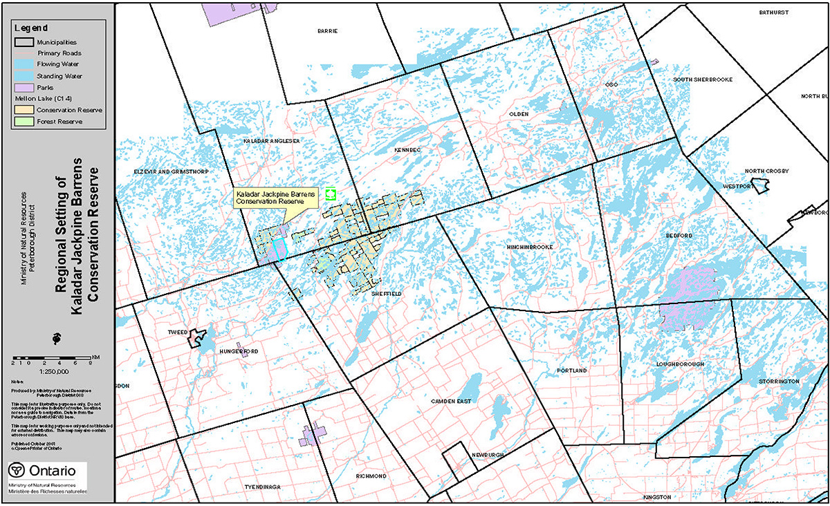
The KJPB-CR is located in the former geographic Townships of Kaladar and Sheffield in the County of Lennox & Addington, three kilometres southwest of the hamlet of Kaladar (intersection of Highways 7 and 41); extending south from Highway 7 to the old Canadian Pacific Railway line. The Reserve consists entirely of Crown land (Figure 1).
Conservation Reserves are established by Regulation under the Public Lands Act. SCI are prepared under the authority of: Procedural Guideline A – Resource Management Planning (PL Procedure 3.03.05), Ontario Ministry of Natural Resources (OMNR) 1997 and as amended by the Ontario’s Living Legacy Land Use Strategy, (OMNR 1999)
1.1 Background information
For many years, the KJPB-CR has been recognized as having significant natural heritage values. Initially identified as an International Biological Preserve (IBP) site in 1974 , it was subsequently identified as a provincially significant Area of Natural Scientific Interest (ANSI) in the Ministry of Natural Resources (MNR) former Tweed District Land Use Guidelines (1983) and confirmed as a Life Science ANSI in Site District 6-10 (White 1993). The most recent inventory (Brownell 1994) provides further details on the area values and potential area boundaries.
The area was proposed for protection in 1994 and two public meetings were held in April 1994. Public input generally supported the protection of the area provided that existing uses were permitted to continue and that undue constraints were not placed on potential mining and other developments adjacent to the area. A summary of public consultations can be found in Appendix 1. The area was formally regulated as a conservation reserve in February 1997.
Background information table
| Name | Kaladar Jack Pine Barrens Conservation Reserve |
|---|---|
| Site Region/District | Lake Simcoe – Rideau Site Region 6E-10 |
| OMNR Administrative Region/ District/Area | Southcentral Region/Peterborough District/Kingston Area |
| Total Area (ha.) | 1,086.4 |
| Regulation Date | February 19, 1997 – Ontario Regulation 53/97 |
| Aboriginal Interests | Interim Traditional Area of the Mohawks of the Bay of Quinte |
| OBM Map Sheets | 1018325049400, 1018325049350 |
| UTM Coordinates | 270390 |
Map 1: Regional setting map of Kaladar Jack Pine Barrens Conservation Reserve
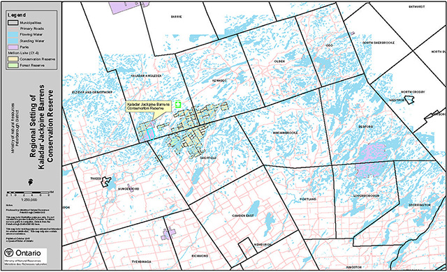
Enlarge Map 1: Regional Setting map of Kaladar Jack Pine Barrens Conservation Reserve
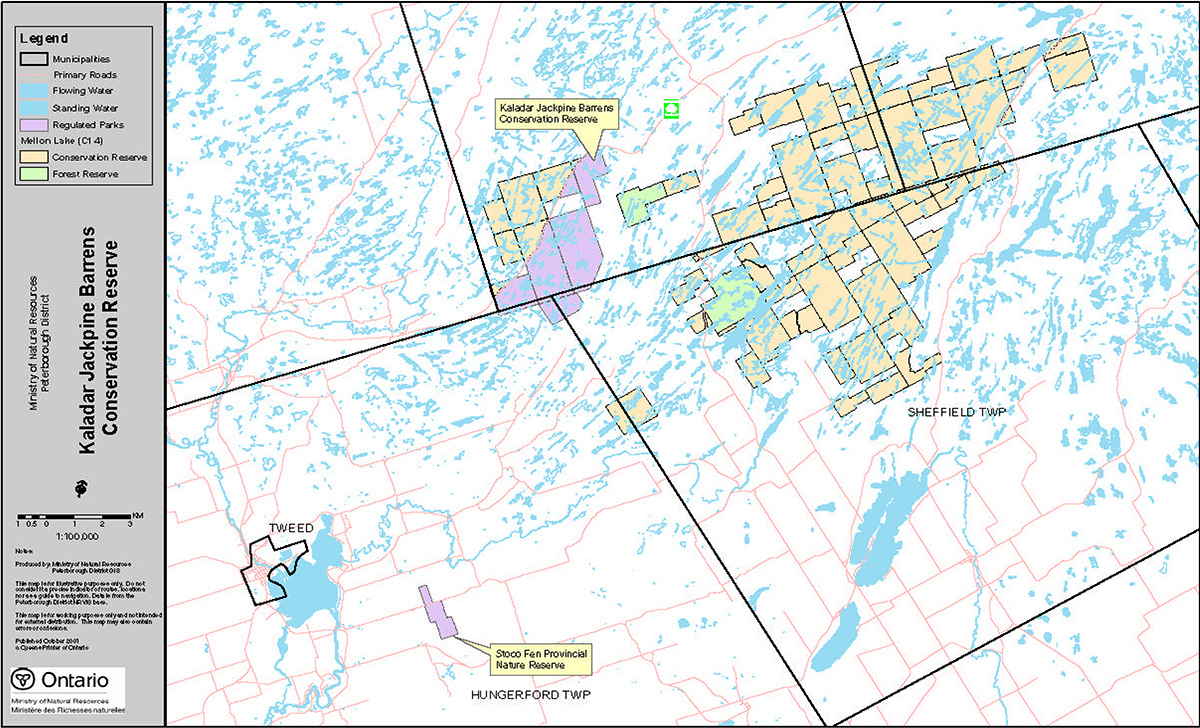
Map 2: Area boundary map of Kaladar Jack Pine Barrens Conservation Reserve
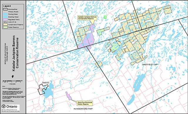
Enlarge Map 2: Area Boundary map of Kaladar Jack Pine Barrens Conservation Reserve
1.2 Representation
Earth science representation:
Bedrock:
Mazinaw Terrane - Central Metasedimentary Belt
- Addington group
- Flinton group
- Mazinaw group
Features:
- Faults bisect area (NW – SE)
- Natural cave and arch erosion forms
Surficial:
- Ridge and valley topography
- Shallow glacial sediments
Life science representation:
Vegetation associations can be grouped into 15 types on landform types
- Wetlands:
- Bog lakes and ponds
- Marsh headwater stream
- Shallow emergent marsh
- Fluctuating shoreline
- Bog
- Thicket or shrub swamp
- Treed swamp
- Upland vegetation:
- Granitic steep ridge slopes
- Open granitic ridge slopes
- Jack pine rock barren
- Oak/red maple barrens on granitic rock
- Oak/red maple barrens on metasedimentary rock
- Mesic – wet mesic deciduous forest on shallow, coarse sandy soils
- Anthropogenic:
- Introduced vegetation
- Subterranean:
- Cave vegetation communities
Flora are significant because they are at their southern range limits (e.g. jack pine) or have southern or Atlantic Coastal Plain (ACP) affinities. An array of fauna (birds, reptiles, amphibians, mammals, and butterflies) make their home in these habitats. A total of 12 species are considered rare at the provincial or national level and considerably more at the regional level.
Cultural resources values:
No research has been completed to date and there are no known values within the reserve. However, the Addington colonization road (1856) did pass just to the east of area and today is known as Highway 41. No settlement activity is known to have occurred within the reserve.
Recreational/economic values:
Historically, fires occurred in the late 1800's or early 1900's. In the early 1960's the area was periodically burned to improve the habitat for blueberries. This activity was discontinued in the late 1960's. Since then the area has been primarily used for deer and limited waterfowl hunting. Recent uses have also included hiking, cross-country skiing, all-terrain vehicle use and snowmobiling. The rugged terrain and limited access makes use of the reserve very challenging for most visitors. Nevertheless, in the early 1970's the area came of interest to naturalists for the Jack pine communities in the reserve. These visitors have walked, snowshoed and/or skied into the reserve. Recreation opportunities remain primarily related to hunting and nature study/interpretation.
1.3 Survey work
| Survey Level | Earth Science | Life Science | Social | Recreational-Economic | Other |
|---|---|---|---|---|---|
| Reconnaissance | None | Checksheet. Lyciuk, 1976 | None | None | None |
| Detailed | None | Brownell, 1994 | None | None | None |
| Requirement | Reconnaissance survey - reserve, special features e.g. cave, arch | Spring plants, Breeding bird surveys | Reconnaissance survey | Study of use and impacts e.g. hunting & ATV's | None |
2.0 Values to be protected
The reserve is located at the boundary between two ecological site regions - 6E and 5E in site district 6E-10. Values include earth/life science and recreational/aesthetic with the emphasis on life sciences (Figure 2).
Figure 2: Values in the Kaladar Jack Pine Barrens Conservation Reserve
| Earth Science | Life Science | Cultural | Aboriginal | Recreational | Economic |
|---|---|---|---|---|---|
| Addington Pluton (Metamorphic) | 44 Vegetation Communities | Aboriginal Use | Mohawks of The Bay of Quinte Interim Traditional Area | Hiking | Trapping Licenses |
| Granite Gneiss | Relatively Undisturbed Condition | Local Landowners For Recreational Use | Mohawks of the Bay of Quinte Indicated Aboriginal Interest For Traditional Land Uses/Co-management | Nature Study | Hunting |
| Cave And Natural Arch | Diversity Of Habitats And Rock Barrens | Snow-shoeing | Ecotourism | ||
| Potential Linkage To Adjacent Natural Areas | X-Country Skiing | ||||
| Rare Species Of Flora And Wildlife | Hunting | ||||
| Snowmobiling |
2.1 Earth science:
Earth science values are focused on features (bedrock and surficial) and processes that represent the chronology of earth history.
a) Bedrock:
The reserve is situated on bedrock within the Mazinaw Terrane (Central Metasedimentary Belt, Grenville Province), a complex terrane of Precambrian (middle Proterozoic) age (Easton 1992) at the southern edge of the Canadian Shield. Rocks of the Grenville Province represent the core of a mountain range built when two continental masses collided, and their subsequent erosion products. Three bedrock types underlie the reserve:
- Addington granite in the middle
- Flinton group to the east
- Mazinaw group to the west, part of the Grenville supergroup. The latter two groups include clastic and carbonate metasediments beneath volcanic gneisses
The majority of the reserve incorporates a relatively small pluton of gneissic granite - the Addington Pluton - which is bisected by five faults aligned northwest to southeast. At one location near Highway 7, the sedimentary gneisses are overlain by a granitic caprock, providing the rationale for the unusual cave and natural arch which was formed by preferential erosion by glacial meltwater streams (Brownell 1994).
b) Surficial:
The ridge and valley landscape that has developed on this strongly oriented bedrock base is rugged and hilly with relief ranging from 169-246 metres above sea level. Surface materials relate to late Wisconsinan glaciation and consist of shallow pockets of glacial till amidst bare bedrock.
These earth science values are of local significance, (Davidson R.J.A. 1981).
2.2 Life science:
The significance of life science values is determined on the basis of five criteria: representation, condition, diversity, ecological considerations and special features.
Representation:
The reserve represents 44 vegetation communities grouped into 15 community types on landform(s). The broad distribution of habitat types is wetland – 14.3%, upland – 85.0%, anthropogenic 0.6% and subterranean 0.1%. A significant vegetation community is the 'Jack Pine rock barrens' which covers 11.0% of the reserve and is one of the most southern stations for this tree species in Ontario.
Condition:
The area’s size, relatively undisturbed nature, containment of a jack pine barren community in a sizeable block, several provincially significant species, proximity to other Crown lands to the north and south make this reserve very important to the natural heritage system.
Diversity:
The variety of rock barrens and wetland communities support a high number of plants and animals. Four broad vegetation community types were identified: wetland, upland, anthropogenic and subterranean (cave). The majority of these values are distributed throughout the reserve.
Ecological considerations:
The size of this area and its proximity to other natural heritage areas (Mellon Lake, Elzevir Peatlands, Hungry Lake, Puzzle Lake and Mount Moriah) is extremely important. This larger 'critical mass' of combined areas improves the long term ecological viability of natural heritage values.
Special features:
An array of species has been identified with varying importance at the regional (R), provincial (P) and national (N) level. Some species are of Atlantic Coastal Plain (ACP) and southern affinities and some have been classified as Vulnerable, Threatened and Endangered (VTE) in Ontario.
Flora:
- 442 species (5 P rare) based on the Atlas of the Rare Vascular Plants of Ontario, Argus 1982.
- Twin-scapped bladderwort
- Cary’s smartweed
- Bulbostyle
- Sharp-leafed Goldenrod
- Shining Sumac.
Fauna:
- 60 birds (1 N/P rare)
- Prairie warbler
- 20 mammals
- 19 reptiles/amphibians
- 42 butterflies (3 P rare species)
- Silver Spotted Skipper
- Olympia Marblewing
- Henry’s Elfin
In summary, the reserve contains a regionally significant Jack Pine Barren that appears to be naturally reproducing, and significant open, granitic and metasedimentary rock barrens, oak and red maple dominated granitic barrens and fluctuating shorelines. Special features and species add further significance of the area within the provincial, natural heritage areas system. Care will have to be taken to ensure that current and future uses, both within and adjacent to the reserve, do not affect these natural values.
2.3 Recreational/aesthetic:
Although no specific studies have been undertaken to date, the reserve receives limited recreational use. This use is primarily limited to hunting upland and limited waterfowl game. All terrain vehicle (ATV) use is primarily for extraction of game during the hunting season. In addition, there is some nature interpretation, hiking, walking, snow-shoeing and cross-country skiing.
The rugged nature of the reserve makes it difficult to access and will limit future use to the traditional uses noted above, with an expansion of the interpretation of the site’s natural values.
3.0 Management guidelines
Figure 3, Indicator Uses For Conservation Reserves – Generic and Specific, tabulates permitted and restricted activities within Conservation Reserves in general as well as within the Kaladar Jack Pine Barrens Conservation Reserve.
Figure 3: Indicator Uses for CR's - Generic and Specific
Recreation
| Activities | Generic Policy Permitted? Existing | Generic Policy Permitted? New | Specific Application |
|---|---|---|---|
| Sport Fishing | Yes | Yes | Yes |
| Sport hunting | Yes | Yes | Yes |
| Food gathering | Yes | Yes | Yes |
| Facility infrastructure | Maybe | Maybe | Maybe |
| Non-trail snowmobiling | Maybe 1 | Maybe 1 | Maybe 1 |
| Non-trail ATV use | Maybe 1 | Maybe 1 | Maybe 1 |
| Rock climbing/caving | Maybe | Maybe | Maybe |
| Canoeing/kayaking | Yes | Yes | Yes |
| Motorized boating | Yes | Yes | Yes |
| Picnicking | Yes | Yes | Yes |
| Camping | Maybe | Maybe | Maybe |
| Trails: Hiking | Yes | Maybe | Maybe |
| Cross country skiiing | Yes | Maybe | Maybe |
| Cycling | Yes | Maybe | Maybe |
| Horse riding | Yes | Maybe | Maybe |
| Snowmobiling | Yes | Maybe | Maybe |
Science, education & heritage appreciation
| Activities | Generic Policy Permitted? Existing | Generic Policy Permitted? New | Specific Application |
|---|---|---|---|
| Research | Yes | Yes | Yes |
| General walking | Yes | Yes | Yes |
| Photography & Painting | Yes | Yes | Yes |
| Wildlife viewing | Yes | Yes | Yes |
| Outdoor Education/Interpretation | Yes | Yes | Yes |
| Collecting | No | No | No |
Commercial activities
| Activities | Generic Policy Permitted? Existing | Generic Policy Permitted? New | Specific Application |
|---|---|---|---|
| Food harvesting | Maybe | Maybe | Maybe |
| Fishing | Maybe | Maybe | Maybe |
| Baitfish harvesting | Yes 2 | Maybe | Maybe |
| Trapping | Yes 2 | Maybe | Maybe |
| Trap cabins | Yes | No | No |
| Resort - outpost camp | Yes 2 | No | No |
| Outfitting - bear management | Yes 2 | No | No |
| Wild rice harvesting | Yes | Maybe | Maybe |
Resource management
| Activities | Generic Policy Permitted? Existing | Generic Policy Permitted? New | Specific Application |
|---|---|---|---|
| Inventory monitoring | Yes | Yes | Yes |
| Featured species management | Maybe | Maybe | Maybe |
| Natural systems management | Maybe | Maybe | Maybe |
Industrial activities
| Activities | Generic Policy Permitted? Existing | Generic Policy Permitted? New | Specific Application |
|---|---|---|---|
| Timber harvesting | No | No | No |
| Prospecting | No | No | No |
| Mining | No | No | No |
| Hydro generation | No | No | No |
| Energy transmission corridors | Yes | No | No |
| Communications corridors | Yes | No | No |
| Transport corridors | Yes | No | No |
| Resource access roads MNR | Yes | No | No |
Other activities
| Activities | Generic Policy Permitted? Existing | Generic Policy Permitted? New | Specific Application |
|---|---|---|---|
| Land disposition | * | No | No |
| Hunt camps | Yes 2 | No | No |
Notes:
On generic policy application in conservation reserves:
1For direct retrieval of game only.
2Transfer requests will be considered in the context of the Statement of Conservation Interest or Resource Management Plan for each conservation reserve.
*Existing dispositions will continue, however, as opportunities arise, the Ministry will acquire and/or remove them outside the CR .
3.1 Land tenure
Background:
KJPB-CR consists entirely of Crown land in the former geographic Townships of Kaladar and Sheffield. Private lands abut the boundary to the south and east and two small blocks of private lands are located between Highway 7 and the boundary. These private lands are not part of the reserve.
Since the reserve is located within an organized municipality, all unopened road allowances have been excluded from the regulated boundaries. In addition, the abandoned Canadian Pacific Railway (CPR) line extending along the southeast boundary is excluded.
The area includes four resident fur harvesting licenses and a major and a minor hydro transmission line. The latter are authorized under annual land use permits. Bell Canada has a fiber optics cable buried along the side of the CPR right-of-way and a snowmobile trail is located on this right-of-way. The reserve has been accessible from Highway 7 via the Beatty Curve Road and the old railway line.
CPR has recently disposed of their interest in the right-of-way to local municipalities, who in turn have an agreement with the Eastern Ontario Trails Alliance (EOTA) to manage the right-of-way for snowmobile and other trail uses. A detailed management plan is being developed by the Trails Alliance for the former CPR line through this area.
Guidelines:
Sale of Crown land within the reserve is not permitted.
A hydroelectric corridor right-of-way bisects the KJPB-CR easterly from Highway #7 to the abandoned CPR line in lots 4 and 5 across Concessions 2, 3 and 4. New hydro electric transmission corridors across the reserve are not recommended. However, maintenance, upgrades and expansions of the existing corridor may be allowed under strict conditions, which will ensure that no significant negative impacts occur to the natural features and values for which the area is identified.
Consideration may be given to acquiring the two small parcels of private lands between Highway 7 and the current boundaries of the reserve.
In order to consolidate the reserve boundaries and to facilitate more effective resource management, the Ministry of Natural Resources would be interested in entering into discussions with the Municipalities of the Townships of Kaladar, Anglesea and Effingham, and the Township of Sheffield to close all unopened road allowances and transfer them to the Crown for inclusion within the conservation reserve, if this matter was acceptable to the municipalities.
3.2 Development
Background:
Currently there is no development within the reserve boundaries, other than the Ontario Hydro hydroelectric transmission lines. Development adjacent to the reserve includes Highway 7 and the old CPR line.
Future development may include some form of mining (Flake Mica) to the east and north of the reserve. Also, there may be a need to provide some basic access to the reserve from Highway 7 along the CPR right-of-way and a small parking area at the end of such an access road.
Guidelines:
No development is proposed at this time.
In time, the development of primary access to the reserve should be considered via the existing Beatty Curve Road to the CPR right-of-way. If use levels increase sufficiently then the need for additional facilities may be considered. This will require discussions with the local municipalities and the EOTA. Additionally, a pull-off may be useful along Highway 7 if a safe site can be identified in consultation with the Ministry of Transportation.
Maintenance of the transmission lines will be monitored and the use of herbicides for vegetation control will be discouraged and may be prohibited.
All proposals for new development within the reserve must meet the requirements of Procedural Guideline B – Land Uses – Test of Compatibility (Appendix 2).
Land use activities surrounding the reserve will be monitored with regard to fire risk and to ensure that the reserve environment (e.g. surface drainage, air, noise and visual) is not affected. The potential development of a Mica mine to the east will have to be closely monitored.
3.3 Recreational activities
Background:
Existing recreational uses are limited to walking, occasional nature interpretation, hiking, hunting, wildlife viewing, snowmobile and ATV trail use, and berry picking.
Guidelines:
The current range of recreational activities will be permitted. The use of off-trail ATV's will be permitted for the retrieval of game during the deer hunt. The impact of this ATV use will be monitored.
New recreational activities will be considered (on a case by case basis) provided they are consistent with maintaining the natural values of the reserve and meet the requirements of Procedural Guideline B (Appendix 2).
3.4 Commercial activities
Background:
Current commercial activities include four resident fur harvesting licenses.
Guidelines:
The four fur harvesting licenses will be continued provided they do not impact reserve natural values. Wildlife populations will be monitored in the normal course of wildlife management and the impact of trapping assessed and reviewed at the time of license renewal. The use of ATV's and snowmobiles for access to trap lines will be permitted subject to review at license renewal time.
Conservation reserves do not permit mining, commercial forest harvesting, hydroelectric power development, the extraction of aggregate and peat or other industrial uses (Public Lands Act, Ontario Regulation 805/94). Other new commercial activities must meet the requirements of Procedural Guideline B (Appendix 2).
3.5 Aboriginal interests
Background:
The site lies within the Interim Traditional Area (as defined in 1994 by the Ministry of Natural Resources) of the Mo hawks of the Bay of Quinte, an area in which to pursue hunting and fishing activities.
During discussions on the establishment of this conservation reserve, the Mohawks of the Bay of Quinte suggested that they would be interested in jointly managing the area with MNR.
Guidelines:
In the creation of this conservation reserve, it is not intended that any existing Aboriginal or Treaty rights, as recognized by section 35 of the Constitution Act, 1982, will be abrogated or derogated. Mutually beneficial partnership arrangements for the management of the area may be investigated, with the Mohawks of the Bay of Quinte.
3.6 Natural resource stewardship
3.6.1 General
Background:
There are minimal commercial values in the resources of the reserve. However, the representative natural values require attention including vegetation, wildlife and landforms.
Guidelines:
The emphasis will be on ensuring that the natural values of the reserve are not negatively affected by current and future uses/activities. Therefore, applications for specific uses will be carefully reviewed. Such reviews will be undertaken either by the ministry, partner organizations and/or proponents.
3.6.2 Vegetation
Background:
Fire appears to have been a part of this ecosystem in the past, but what is not clear is whether fire was natural or human introduced. In the future, vegetation management of the 'barrens' may require the introduction of fire into parts of the ecosystem to ensure long term regeneration of the reserve (e.g. Jack Pine forests).
Guidelines:
Further studies will be conducted on fire and consideration will be given to the introduction of fire into specific components of the reserve ecosystems.
3.6.3 Wildlife
Background:
Brownell (1994) identified a number of sensitive faunal species (e.g. fisher, lynx, wolf and otter). Populations of these species will be monitored by the Ministry, through the ongoing review of the fur harvesting licences.
Guidelines:
Limitations on fur harvesting of some faunal species may be required to maintain viable population densities.
3.7 Cultural resource stewardship
No values have been identified within the reserve to date. Interested partners will be encouraged to undertake inventories and studies of the area.
3.8 Client services
Background:
Site access and services have been very limited to non-existent to date.
Guidelines:
The focus will be on low key information and self-interpretation of reserve values and features. Priority will be placed on the preparation of an information brochure (with map) to highlight area values and appropriate uses to ensure the protection of those values. The Ministry will seek interested partners to assist in the preparation of this brochure.
Conservation Reserve signs may be posted strategically around the periphery to indicate that the area is a conservation reserve. In addition, a 'site sign' (Kaladar Jack Pine Barrens Conservation Reserve) near a parking area, may be considered once appropriate access to the reserve has been established (e.g. from Highway 7 via the Beatty Curve Road). This potential parking lot would require discussions with the local municipalities, adjacent landowners and the Ministry of Transportation.
3.9 Research
Background:
Research to date has consisted of inventories of the natural values of the reserve, particularly life science values. This inventory work is still not complete and should be continued as opportunities are presented. The unauthorized past collection of fauna (skinks) for DNA research work without formal approvals is of concern to the Ministry.
Guidelines:
The Ministry will encourage further inventory and documentation of natural and cultural values and the assessment of use and activity impacts on the reserve. The reserve’s scientific values should provide opportunities for partnerships with various colleges and universities.
Initial emphasis should be placed on the identification of spring plant communities and breeding bird surveys. A preliminary assessment of earth science values should be undertaken to place the cave and natural bridge features in proper perspective and determine the extent of these 'karst-like' features.
All research work should follow existing policy and procedures for research activities within conservation reserves including written authorization by the Ministry as noted in Procedural Guideline C – Research Activities in Conservation Reserves (Appendix 3).
3.10 Marketing
Background:
There has been no promotion of the area to date.
Guidelines:
Considering the rugged nature of the reserve, there should be little marketing of the area to the general public. The future should see the provision of information on the natural heritage values and their role in the provincial and regional natural heritage areas system. This information may be provided in combination with information on other nearby protected areas established through Ontario’s Living Legacy.
This can be done through a low key brochure and map that would be available through Ministry offices and local tourist information centres.
4.0 Implementation
Administrative responsibility for this Conservation Reserve rests with the Peterborough District and the Kingston Area Office of the Ministry of Natural Resources. The Area Office will continue with the custodial care of the Reserve and will also seek partnerships with local interests, wherever appropriate.
Emphasis will be placed on awareness information highlighting appropriate uses. This may be undertaken with the assistance of local groups/partners. Priorities include:
- Prepare a brochure on the reserve and its values
- Over time, establish a designated entry route and access point, and consider the need for a pull-off along Highway 7
- Erect a site identity sign and periphery Conservation Reserve reference signs as appropriate
- Encourage further inventory and research activities to enhance information on the reserve
- Commence discussions with the municipalities for the closure of all unopened road allowances within the reserve
- Consider the acquisition of the two private lots along Highway 7
- Consideration of links to adjacent protected areas, particularly as it relates to the provincially significant Little Skootamatta Creek wetland, north of the KJPB
5.0 Review and revision of the Statement of Conservation Interest
This SCI will be subject to review and revision on an ongoing basis. If changes are required to this SCI, they will occur through a standard process of minor and major amendments. Minor amendments will be processed in a relatively informal manner and will require the approval of the Area Supervisor. These amendments will deal with uses and activities that do not affect any of the policies in this SCI (e.g. new uses and/or activities that are consistent with existing use impacts).
Uses and/or activities that were not anticipated in the approved SCI and which may have an impact on the values of the Reserve will require a major amendment. This will include an opportunity for public comment and will require the approval of the District Manager and Regional Director.
Appendix 1: A summary of public consultation
The following provides a summary of public comment received during the April 1994 public consultation to establish this conservation reserve. Public comments saw a majority of people in favour of the establishment of the Conservation Reserve, although many had specific concerns.
Several local residents were opposed to proposed restrictions on the use of all-terrain vehicles (ATV), indicating that ATV access was essential for hunting. ATV use does not appear to have had a significant impact on the property to date and it would be reasonable to permit continued use during deer hunting and winter under controlled conditions and with appropriate monitoring.
Concern about a large mica deposit on adjacent lands has been discussed with the Ontario Ministry of Northern Development and Mines. The mineral values have been well documented and do not extend into the conservation reserve.
Several landowners were concerned that the new protected areas would depreciate land values in the area. There was also general opposition to increased regulation of both Crown and private land, coupled with the view that urban residents are imposing controls. The conservation reserve protection designation is intended to ensure protection of environmental values, while having limited impacts on existing users.
Appendix 2 procedural guideline B – Land Uses – Test of Compatibility (PL procedure 3.03.05)
The Conservation Reserve policy provides broad direction with regard to the permitted uses. The policy provides only an indication of the variety of uses that will be considered acceptable in conservation reserves. The only caution is that "any new uses, and commercial activities associated with them, will be considered on a case by case basis, and, they must pass a test of compatibility to be acceptable." What does a 'test of compatibility' mean?
An examination of this must start from the premise of why an area is set aside – specifically, its representative natural heritage values. Criteria are then identified to guide compatibility considerations. These criteria apply to the long-term acceptability of both existing uses and new uses.
-
Conformity to SCI/RMP: SCI describe values for which an area has been set aside and the range of appropriate uses that will be permitted in the area. SCI may also speak to the acceptability of other 'new' uses currently not occurring in the area.
The first 'test' is: "do proposed new land uses and/or commercial activities conform to the direction of the SCI/RMP for the conservation reserve? Would the new use(s) depart from the spirit of appropriate indicator land uses in the SCI/RMP?"
- Impact Assessment: If the proposed use(s) pass test 1 it is important to determine their impact on the area before they are approved. This should include the following:
- Impact on natural heritage values: "will the new use(s) impact any natural values in the area? If so how and to what degree? Is it tolerable?"
- Impact on cultural values: "will the new use(s) impact ant historical or archaeological values in the area?" Impact on research activities: "will the new use(s) affect research activities in the area?"
- Impact on current uses: "will the new use(s) have any negative impact on the array of current uses?"
- Impact on area administration: "will the new use(s) increase administrative costs and/or complexity?" (For example, the cost of area monitoring, security and enforcement)
- Impact on accommodating the use outside the conservation reserve: "Could the use(s) be accommodated as well or better outside the conservation reserve?"
- Impact on socio-economics of the area: "will the new use(s) affect the communities surrounding the area in a positive or negative way?" (For example, will the new use make an area less remote thereby affecting a local tourism industry that is dependent on the area’s remoteness for its appeal?"
- Impact on area accessibility: "do the new uses provide someone exclusive rights to the area or a portion of the area to the exclusion of other existing uses?"
Figure 3 provides a guide of indicator uses for the consideration of uses that may be permitted within conservation reserves. For any specific conservation reserve that test of compatibility should be applied to determine which specific uses are acceptable.
Appendix 3 procedural guideline C – Research activities in Conservation Reserves (PL procedure 3.03.05)
Purpose
To encourage contributions to the goal of conservation reserves by:
- Providing direction for research activities associated with conservation reserves
- Establishing a process for the review and approval of proposals by researchers, which could have an impact on the values protected by the conservation reserve
Definition
Research means any investigation or study of the natural, cultural, economic, management or other features or characteristics of conservation reserves.
Guidelines
Research will be encouraged to provide a better understanding of the natural values protected by a conservation reserve and to advance their protection, planning and management. The Statement of Conservation Interest will define, for each conservation reserve, the key research issues, set out the parameters within which research may occur and identify research needs.
Applications and approvals
Researchers must apply in writing to the Area Supervisor for permission to conduct research. The request letter must contain a statement explaining why the proposed research should be undertaken in the particular conservation reserve in preference to another location.
Proposals will be reviewed and approved by the Area Supervisor, guided by the SCI prepared for each reserve (see Guideline A – Resource Management Planning) and using Guideline B – Land Uses – Test of Compatibility. Permission must be granted in writing, including any conditions to be met in conducting the research, prior to the undertaking of any research project.
Term and conditions
Permission to conduct research under this policy will be valid for a period of 12 consecutive months from the date of issue. Permission to continue a research project for an additional periods of 12 months or less may be granted upon submission of a written request and a progress report. The Ministry may require the posting of collateral to assure that the terms and conditions of granting permission are met.
The Area Supervisor may suspend or revoke permission at any time for failure on the part of the researcher to meet:
- The intent of this policy
- The requirements under the Public Lands Act, including all amendments, where applicable
- The requirements under any other Act or regulations of Ontario or Canada, including those governing the taking, handling, storing, confining, trapping, excavating and marketing any specimen, artifact, information or action (for example, scientific collector’s permit)
- The conditions and agreements specified in granting permission
Final report
The researcher will submit copies of reports, publications and theses following the results of the project to the Area Supervisor.
References
Argus, G.W. et al, Atlas of the Rare Vascular Plants of Ontario, Parts 1- 4. Botany Division, National Museum of Natural Sciences, Ottawa, 1982- 1987.
Brownell, V. R., A Biological Inventory and Evaluation of the Kaladar Jack Pine Barrens ANSI, Tweed: Ontario Ministry of Natural Resources, 1994.
Davidson, R. J. A Framework for the Conservation of Ontario’s Earth Science Features. Toronto: Ontario Ministry of Natural Resources, Division of Parks, 1981.
Easton, R. M. The Grenville Province and the Proterozoic History of Central and Southern Ontario: in Geology of Ontario, Ontario Geological Survey, Special Volume 4, Part 2, p. 714 – 904. Toronto: Queen’s Printer, 1992.
Lyciuk, L.Y., Kaladar Jack Pine Forest – Life Science Inventory Checksheet. Kempville: Ontario Ministry of Natural Resources, 1976.
Ontario Ministry of Natural Resources, Tweed District Land Use Guidelines. Tweed: Ontario Ministry of Natural Resources, 1983.
Ontario Ministry of Natural Resources, Procedural Guideline A – Resource Management Planning (PL Procedure 3.03.05), 1997 as amended by the Ontario’s Living Legacy Land Use Strategy , 1999.
White, D. J., Life Science Areas of Natural and Scientific Interest in Site District 6E-10. Kempville: Ontario Ministry of Natural Resources, 1993.
Kaladar Jack Pine Barrens Conservation Reserve Statement of Conservation Interest September 13, 2001