Kap-Kig-Iwan Provincial Park Management Plan
This document provides direction on the management of Kap-Kig-Iwan Provincial Park.
ISBN-0-7743-6260
MNR-5164
Kap-Kig-lwan Provincial Park Management Plan
© 1984 Government of Ontario
Additional copies of this publication are obtainable only from the Ministry of Natural Resources, Kirkland Lake District Office
P.O. Box 129, Swastika, Ontario
P0K 1T0
Telephone: 1-705-642-3222
1.0 Introduction
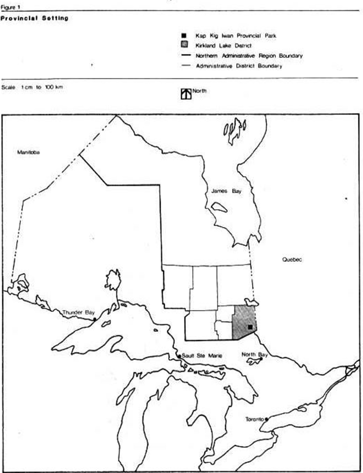
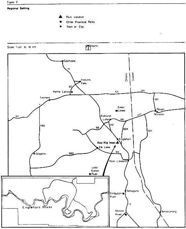
Kap-Kig-Iwan Provincial Park is situated in Northeastern Ontario, 2 km south of Englehart and 520 km north of Toronto. It is located in Kirkland Lake District, which is part of the Northern Administrative Region of the Ministry of Natural Resources (Figures 1 & 2).
Kap-Kig-Iwan, although the smallest provincial park in the Northern Region, is regionally noted for its flora, fauna and geological features. It is a quiet and restful place, small but charming. Two of the outstanding attractions of the park are its series of spectacular waterfalls and its numerous scenic lookouts. The purpose of this management plan is to ensure proper protection and management of these significant resources while developing the park to its optimum level of recreational capacity.
The Kap-Kig-Iwan Provincial Park Background Information document provides a detailed summary of the park’s resources, and is available on request from the Kirkland Lake District Office. This document contains policies that will guide the management of the park’s resources and it’s operation now, and in the future.
2.0 Significant issues
There are no significant issues that require resolution in this plan.
3.0 Park policies
3.1 Park classification
Kap-Kig-Iwan is classified as a Natural Environment park, in accordance with the 1978 Ontario Provincial Parks: Planning and Management Policies. Natural Environment parks are intended to incorporate outstanding recreational landscapes with representative natural features and historical resources to provide high quality recreational and educational experiences. The following policy statements provide direction for the preservation, management and development of park resources.
3.2 Park goal
To provide within a natural environment setting, year-round opportunities for compatible recreational, educational and scientific pursuits.
3.3 Park objectives
Kap-Kig-Iwan will contribute to the achievement of the four objectives of the Ontario Provincial Park System.
3.3.1 Protection
To protect provincially significant elements of the natural and cultural landscape of Ontario.
Kap-Kig-Iwan contains a variety of earth and life science features, which will be protected through appropriate zoning and management. It contains 14 site types, a variety of rare vascular plants and provides representation of site district 4E5. The rock within the park is characteristic of three distinct geological periods, and the park is well known for its avifauna, with 89 species of summer birds recorded.
3.3.2 Recreation
To provide 27,900 camper days annually (at optimum 60% capacity) for provincial and non-resident use while preserving natural conditions in the park.
To provide 28,104 user days of year-round day-use.
3.3.3 Heritage appreciation
To provide opportunities for the exploration and appreciation of the outdoor natural and cultural heritage of Ontario.
3.3.4 Tourism
To provide Ontario’s residents and out-of province visitors an opportunity to discover a distinctive region of the province.
Kap-Kig-Iwan will provide day -use and camping opportunities for local residents and passing travelers. They will be encouraged to explore the park as well as other sites and attractions in the surrounding area.
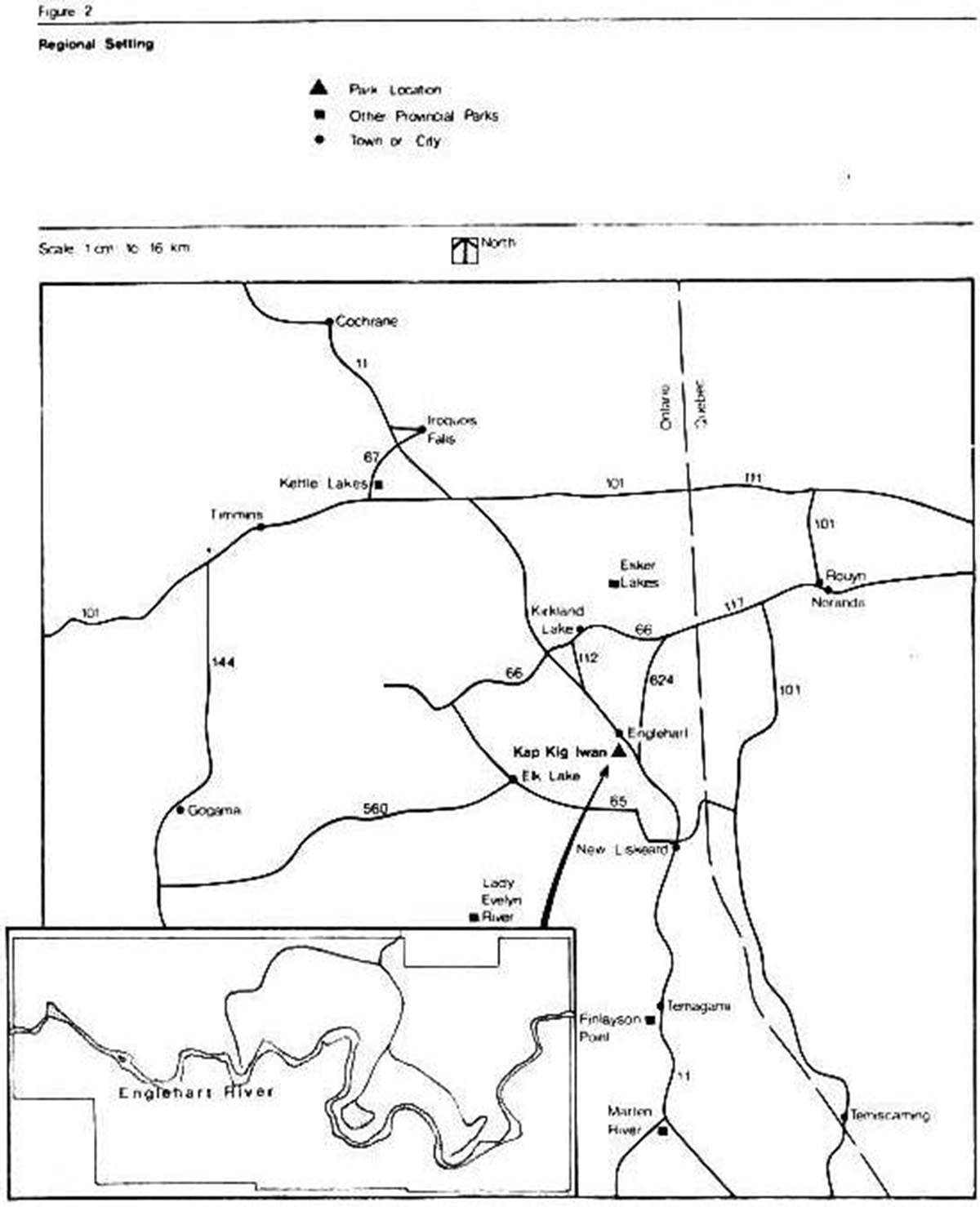
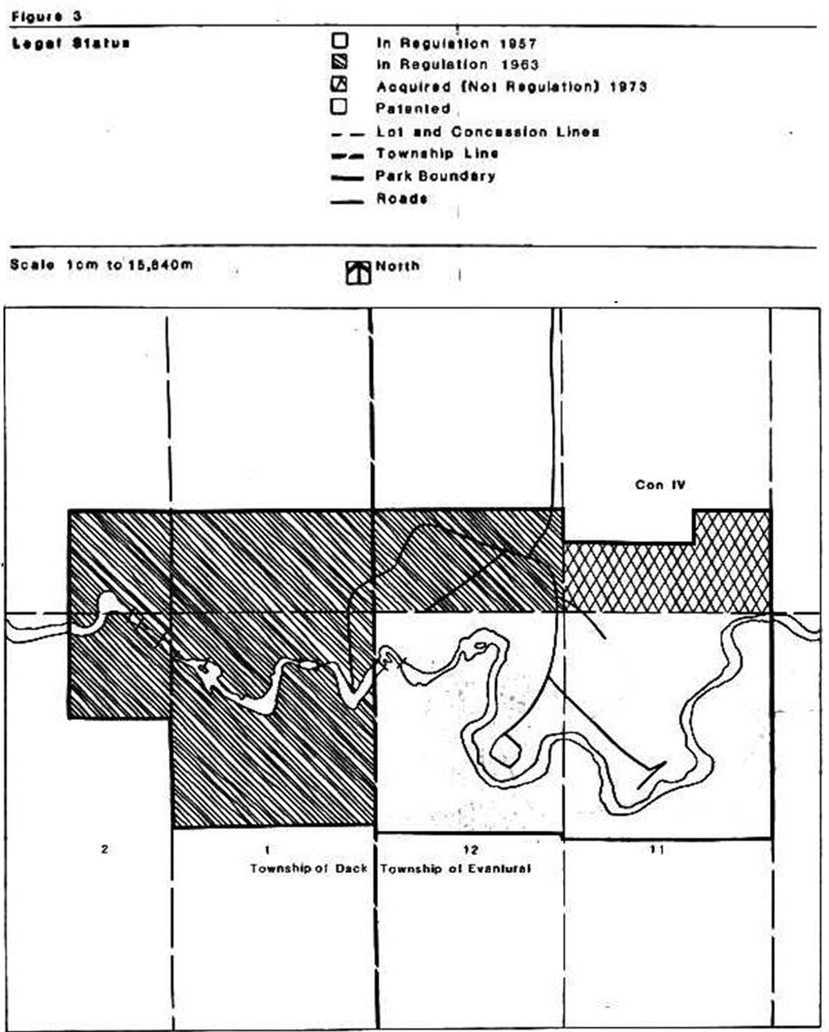
3.4 Park area (Figure 3)
In 1973, two small parcels (199 S.S.T. and 16-272 S.S.T.) in the south half of the south half of Lot 11, Concession IV, Evantual Townships, with a combined area of 26 ha were acquired. These have not yet been brought under regulation. An amendment to Ontario Regulation 114/71, S. 1(3) will be processed upon approval of this plan.
A modest land acquisition program is proposed to provide limited capacity for expansion and to provide increased protection for park resources.
Park expansion is proposed in two directions. The first expansion is 6.9 ha of the south half of the south half of Lot 11, Concession IV, Evantural Township. The total area involved is 6.9 ha. The purpose behind this expansion is to secure additional buffer for the park entrance, and prevent any undesirable development on this private parcel.
The second expansion west of the park along the Englehart River serves to consolidate a large block of nearby Crown land with the park proper. A 100 metre corridor on both sides of the river would be secured from patented lots SW 1/4 Lot 2, Concession IV, NW 1/4 Lot 2, NE 1/4 Lot 3, Concession III, and Lot 4, Concession IV, Dack Township. This corridor in turn would connect with Crown lots S 1/2 Lot 3, Part S 1/2 Lot 4 and N 1/2 Lot 5, Concession IV, Dack Township. These additions would serve to provide hiking and remote overnight camping opportunities. Total area involved in this second acquisition would be 25 ha.
The first expansion will be zoned Development and Natural Environment; and the second Natural Environment and Nature Reserve.
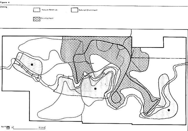
3.5 Zoning
Of the six zoning possibilities that exist for a natural environment park Kap-Kig-Iwan Provincial Park utilizes three: the development zone, the natural environment zone and the nature reserve zone (Figure 4).
3.5.1 Nature reserve zone
Nature reserve zones are intended to protect representative geomorphological and/or vegetative features, which are of regional or provincial significance and of sufficiently high quality to warrant preservation and recognition.
Three nature reserve zones have been delineated in Kap-Kig-lwan Provincial Park. All are adjacent to the Englehart River. One (NR-l) is at the west end of the park in the Hell’s Gate area and occupies approximately 11 ha. This zone is representative of flora associated with Precambrian bedrock in rocky rivershore and rapids terrain. It contains 4 plant species rare to the Northern Clay Belt. Three of these species are north of their normal range and one south of its range. Examples of early Precambrian metavolcanic rock are visible in the riverside outcrops.
The second nature reserve zone (NR-2) is situated between the area south and west of the High Falls parking lot and picnic shelter to Aspen Campground, and is 30 ha in area. It contains a number of riparian silt plant associations as well as Precambrian bedrock associations. Notable bedrock features within this zone are: the beaver meadow off the Sentinel Cedar Trail; the black ash—balsam poplar bottomland south of the river, (which is enriched by annual alluvial deposits, creating a prolific ground cover, some species of which are at the northern limit of their range); and the associations of mosses and vascular plants located at High Falls.
There are also a number of geological/ geomorphological features in this zone: High Falls; the Englehart River - Evanturel Creek Fault Zone, which separates the Precambrian metavolcanics west of High Falls and the Quarternary sediments east of High Falls; two former ox-bow lakes, one south and one north of the river; the slump area north of the river, with its excellent exhibition of varved clays.
The third nature reserve (NR-3) is easterly and northerly of the group camping area and is approximately 16 ha in area. It contains mesic upland plant associations on the hilltops above the river and riparian silt associations in the bottomlands. Of importance here are the black ash-elm flat east of the group camp area, which is well known locally for its spring flowers; the active slump area vegetative associations east of the river; the mesic upland associations on the uplands at the north and south ends of the reserve; the vegetation associated with the calcareous boulder and limestone/shale islands in the river.
Geomorphological features included in this zone are two varved clay slump areas, one north and one south of the river, two deltic formations above the slumps; the crustacean rich limestones and shales along the river.
All nature reserves provide excellent habitat for the park’s varied and abundant avifauna.
3.5.2 Natural environment zone
Two natural environment zones (NE-b NE-2) have been delineated with a total area of 190 ha. They encompass most of the flat uplands outside the development zone, most of the ravines and gullies draining into the river and the entire Englehart river outside of nature reserves. These zones provide a buffer between nature reserves and development zones, except where this is accomplished by natural features such as steepness of slope or the river. There are existing and potential trail opportunities for summer and winter recreation.
3.5.3 Development zone
This is a 78 ha zone (0-1) encompassing the existing developed and potentially developable areas of the park. Day-use such as picnicking will be confined to two areas. Existing tent and trailer camping is also in two areas, one providing tent/trailer sites without electricity, and the other trailer pull-through sites with electricity. Two additional areas are proposed, one with electricity and pull-through sites, and 2 with tent/trailer sites. Group camping is available to approved groups. Support buildings such as maintenance and storage buildings, office/residence, control booth, pump house, junior ranger camps, comfort stations and privies will be located in this zone. The sewage lagoon and woodyard are also in this zone. Pressure water outlets will be provided in all campgrounds, and electrical outlets to approximately 50 percent of campsites.
4.0 Resource management
The park will be managed in accordance with the general planning and management policies for natural environment class provincial parks (Ontario Provincial Parks-Planning and Management Policies). Specific direction, where needed to meet requirements special to Kap-Kig-Iwan, is provided below.
Although the policies are presented in separate categories, all planning and management will recognize that the components are interrelated and that an integrated approach will be required in order for the park to achieve its objectives.
4.1 Vegetation
Vegetation in the park will be managed to fulfill protection and recreation objectives. The removal of trees will b& permitted only where there is a threat to human safety and property or where it is necessary in order to meet the park’s protection and recreation object yes.
The Ministry of Natural Resources is responsible for fire control and fire equipment is provided in the park in order that park staff can react to any fire outbreak. Wild fires in all zones will be suppressed. The municipal fire department in Englehart will be utilized as required.
Aerial spraying for the release of vegetation is prohibited. Pathogenic spraying will not be permitted unless the park is seriously threatened by insects or disease. At such time, spraying will follow guidelines established by the Ministries of Natural Resources and the Environment. Non-native plants will not be introduced.
Berry picking and limited personal consumption of edible wild plants other than those found in nature reserve zones will be permitted. Commercial operations will not be permitted.
Three nature harvesting zones have been established to protect regionally rare vascular plant species.
Environmentally acceptable herbicides may be used as required for aquatic weed control in the sewage lagoon, and for poison ivy control in the development zone.
Tending of plantations will be carried out as required to improve aesthetics-and accessibility of stands while encouraging mixed, uneven aged stands. Underplanted trees will be hand released from undesirable competition.
A vegetation management plan for the park will be completed within two years of the approval of the park management plan. It will provide silvicultural prescriptions designed to improve stand diversity, quality and aesthetics, particularly in the development zones.
4.2 Fisheries
Periodic creel census programs will be implemented for that stretch of the Englehart River passing through the park. Fisheries management will be in accordance with the provisions of the Kirkland Lake District Fisheries Management Plan.
As the river bisects the entire park, and fishing will not endanger the values identified in the three nature reserve zones, it will be permitted in all zones.
4.3 Landforms
Three nature reserve zones will be established ‘to encompass sections of two distinct geological time periods; part of the fault between them, and features representative of both.
5.0 Client services policies
5.1 Visitor services
The visitor services program will be based on self-use facilities. This is in accordance with the regional visitor services plan, and will complement the regional and park marketing strategies. Program emphasis will be in nature reserve and natural environment zones with some displays in the development zone.
Major themes to be interpreted should include the parks geological history and its pre-contact aboriginal occupations. A series of panels and exhibits will be placed in key locations for public viewing.
5.2 Marketing
A marketing plan has been developed for the park, primarily to encourage increased visitation. The park’s proximity to Highway 11, a major travel corridor in Northeastern Ontario, combined with its superb aesthetics, will continue to be the focus of marketing initiatives.
6.0 Park services
6.1 Water supply
Kap-Kig-Iwan’s current water source is a deep drilled well in the maintenance area. Water is extremely hard, and water-softening equipment seems ineffective. By the 1985 operating season, the conversion to water supplied by the Town of Englehart system should be completed, thus alleviating the problem.
6.2 Emergency services
An emergency plan has been prepared to provide guidance for park staff in foreseeable emergency situations. Park staff will continue to be familiar with the contents of this plan.
6.3 Park enforcement
There are very few problems with rowdyism and vandalism from park users during the operating season at present. However, due to the park’s proximity to a town and a major highway, there are periodic occurrences of vandalism, particularly in the off-season when the park is unstaffed. Any increase in this vandalism may necessitate gating of the park during spring and fall periods. This should be avoided if possible, due to the high level of legitimate use during the same period. A security officer is employed on weekends only during the operating season. Co-operation with the Ontario Provincial Police Detachment at Englehart has been excellent to date and they should be called for any situation beyond our control, as well as encouraged to make evening and weekend patrols of the park.
7.0 Development
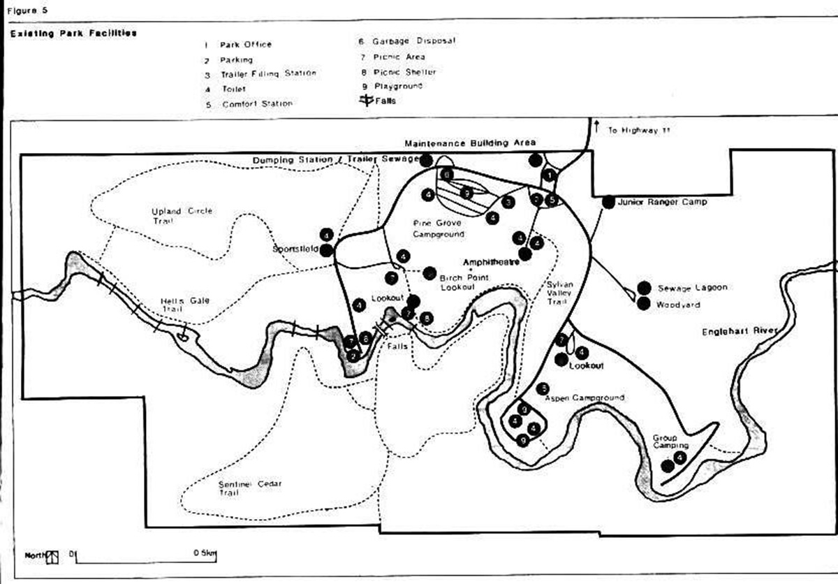
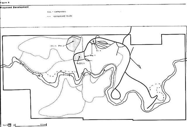
Development will be staged in 2 phases commencing as demand indicates and funding permits (Figure 5 & 6).
7.1 Campsites
An additional 61 campsites will be constructed: 22 pull through sites with electricity and 39 tent/trailer sites. Only 6 of the tent/trailer sites will have electrical outlets.
7.2 Trails
A proposed expansion west along the Englehart River, would permit a hiking trail to be constructed parallel to the river. Interior campsites could also be strategically located along this trail. A 0.7 km trail east of the group camp area will be constructed to interpret features in the nature reserve situated there. Other trails (cross-country and snowmobile) will be developed and maintained as funding permits and demand dictates.
7.3 Roads
Main interior roads will receive additional granular base and be paved. Campground roads will have crushed rock applied. The park access road has been upgraded to a M.T.C. secondary highway standard. An M.T.C. takeover of the road will be sought.
7.4 Electrical transmission lines
Primary electrical transmission lines will be placed underground where possible.
7.5 Implementation strategy
The preceding recommendations will be implemented with formal approval of the management plan, and allocation of appropriate funds.
This management plan will be reviewed not less than once every 10 years following its approval or as the need arises. Data collection and environmental quality monitoring will be conducted regularly.
Proposed phasing of development
Phase I
Campsites
- construct 6 tent/trailer sites directly west of Pinegrove Campground and 22 pull through sites in the converted parking area
Transmission line
- bury part of the primary electrical transmission line
Phase II
Campsites
- construct 33 tent/trailer campsites without electrical service
Figure 1: Provincial Setting

Figure 2: Regional Setting
Figure 3: Legal Status
Figure 4: Zoning
Figure 5: Existing Park Facilities
Figure 6: Proposed Development
References
Ontario Department of Lands and Forests. Ontario Provincial Parks Classification System, 1967, Parks Branch, Toronto.
Ontario Ministry of Natural Resources. Kap-Kig-Iwan Provincial Park Background Information, (unpublished), Kirkland Lake District Office.
Ontario Ministry of Natural Resources. Northern Region Parks System Visitor Services Plan, 1978, Regional Office, Cochrane.
Ontario Ministry of Natural Resources. Ontario Provincial Parks Landscape Design Principles and Guidelines, Outdoor Recreation Group, Toronto 1977.
Ontario Ministry of Natural Resources. The Vegetation of Kap-Kig-Iwan Provincial Park, J.R. Riley, 1979
University of Waterloo. Interpretation in Parks - The Earth Science Component, M.A. Dissertation, Department of Geography, Andrew J. Cotton, 1980.