2017 Terms of Reference: Kashechewan First Nation
Terms of reference for Kashechewan First Nation community based land use planning.
On this page
- Vision statement
- Elder acknowledgement
- Aboriginal, treaty rights and inherent rights
- Historical background
- Principles for planning
- Planning area
- Planning subjects and outcomes
- Land use planning responsibilities
- Planning stages and intended timelines
- Planning initiation and engagement timeline: 2008-2009
- Community Based Land Use Planning preparation timeline: 2009-2012
- Terms of Reference development timeline: 2012-2017
- Draft Community Based Land Use Plan projected timeline: 2017-2019
- Final Community Based Land Use Plan projected timeline: 2019-2020
- Plan implementation projected timeline: 2020-onward
- Decision making and approvals
- Information management
- Issue resolution process
- Contacts
- Appendix A - Enhances engagement agreement
Terms of Reference for a Community Based Land Use Plan
Prepared in partnership between Kashechewan First Nation and the Ontario Ministry of Natural Resources and Forestry
December 2017
Kashechewan First Nation and the Ministry of Natural Resources and Forestry are pleased to sign the Terms of Reference for the Kashechewan First Nation Community Based Land Use Plan. Approvals have been provided by:
- Kashechewan First Nation Band Council Resolution; and
- Ontario, by the Minister of Natural Resources and Forestry administering the Far North Act.
As we begin this planning process, Kashechewan First Nation and the Ministry of Natural Resources and Forestry affirm our commitment to work together with mutual respect and in good faith.

On behalf of Kashechewan First Nation
Chief Leo Friday
Kashechewan First Nation
December 14, 2017
On behalf of Ontario
Kathryn McGarry
Honourable Kathryn McGarry
Minister of Natural Resources and Forestry
December 14, 2017
![]()
![]()
Vision statement
The lands and waters are vital elements of the cultural and spiritual existence of our First Nations since time immemorial. This relationship between the First Nations people and lands and waters must be the foundation of all future decision making and planning. Our vision statement is:
- Kashechewan First Nation will continue to practice its ancestral and spiritual role as stewards for the lands, waters and natural resources that was given to us as a sacred gift from our creator.
- Kashechewan First Nation will pursue sustainable economic development opportunities while considering the importance of protected areas for future generations.
This philosophy expresses our intention to maintain the First Nation’s relationship to the lands and waters, and to maintain our First Nation way of life with these lands and waters and their uses and activities. New practices will integrate with traditional uses of the land in a way that is guided by our traditions, cultural values and principles.
Elder acknowledgement
Elders are very important contributors to land use planning. The term Elder refers to someone who has attained a high degree of understanding of history, traditional teachings, culture values, ceremonies, and healing practices. First Nations Elders are Indigenous historians and knowledge keepers who are focused on the wellbeing of all lands, waters, wildlife, environment and its people. Elders are consulted for their perspective; they have earned the right to pass this knowledge and wisdom on to others and to give advice and guidance on issues affecting their communities and Nations.
First Nation people value their Elders and address them with the utmost respect. Elders are asked to offer prayers to bless an event or meeting or to do the opening or closing prayers or ceremonies. They are also served first; they never have to wait in line, and are never left standing if chairs are unavailable. A certain protocol should be followed when requesting an Elder’s assistance. This protocol may vary but typically Elders are offered tobacco when their assistance is requested.
Aboriginal, treaty rights and inherent rights
Kashechewan First Nation recognizes and affirms the oral treaty as agreed by Kashechewan in 1905 at the Old Post Albany Reserve Number 67 Island.
The Community Based Land Use Plan (CBLUP) will be prepared in a manner that is consistent with the recognition and affirmation of existing Aboriginal and Treaty rights in section 35 of the Constitution Act, 1982.
Kashechewan First Nation will bring their understanding of their inherent rights to the planning process. In Kashechewan First Nation’s view, inherent rights are rights which have been practised and enjoyed since before European contact.
Historical background
History
Kashechewan First Nation brings an understanding of the relationship of people, lands and resources as their foundation for planning. As expressed in words below, all of these concepts will be brought out and integrated into the land use plan as a set of principles to be prepared, structured and balanced properly in planning by Kashechewan First Nation.
Kashechewan Crees have lived in these Lands and used the James Bay (Wee-nee-peg-kook) waters and surrounding rivers and lakes for generations.
Our ancestors - We have been and continue to be custodians and stewards of the lands and waters and all their resources. We multiplied and spread across a vast territory.
Our Cree origin taught us spirituality and everything we needed for our holistic wellbeing through kinship, language, culture, history, and traditional governance practices.
Our relationship to the lands and waters are an integral part of our cultural and economic existence and we are a part of this land.
Our Elders passed on oral and pictographic knowledge of the traditional values and teachings to guide our responsibilities in the safe keeping of our homeland to sustain our resources of life for future generations.
There are elders alive today who still remember this knowledge and history and pass down orally this way of life and existence.In the summer of 1905 at She-Ban-Nuck (Old Post) Albany River, Treaty No. 9 Nation to Nation treaty was orally agreed to and signed, and nothing would be changed and the people would continue to harvest and survive from the resources of the land as they had for countless generations. It means our children continue to learn the ways of their ancestors and that Cree is the language of the land.
We never agreed to draw our territory on a piece of paper and never surrendered our rights and resources to this territory.
In the year 1957, some members moved to the north shore, building tents and cabins on reserve no. 67. This move was based on better services of housing, education, health and infrastructure and today, known as Kashechewan.
Principles for planning
KFN and Ontario (represented by Ministry of Natural Resources and Forestry, Far North Branch, in consultation with other branches and ministries) will be guided by the following principles as they build the CBLUP.
- Planning will be respectful of the traditional values and uses of KFN’s ancestral lands. These values will be the basis of all phases of the planning process within the KFN Planning Area of Interest.
- Guidance of the KFN elders will be respected and followed throughout the planning process.
- Consideration of the needs and interests of future generations.
- Committed to continual learning and self-improvement, and strive for excellence in land use decisions.
- Information brought forward from various perspectives and knowledge sources will be respected and considered in decision making.
- Kashechewan First Nation and Ontario will continue working together and respecting each other throughout and beyond the planning process.
- Planning decisions will be based on the best available data and information, drawn from both Indigenous traditional knowledge and western science.
- Careful consideration of baseline information will be used with regard to the physical environment and in the context of climate change to protect community health and safety.
Goals and objectives for planning
Goals
KFN and Ontario are committed to creating a CBLUP for KFN’s ancestral lands which is based on Elder and community Indigenous traditional knowledge (ITK), as well as the best available scientific information. The collective decisions derived from this information will be used to seek an appropriate balance between protection interests and sustainable economic development opportunities for all lands and waters within KFN’s Planning Area of Interest for both present and future generations.
Objectives
Objectives under Section 5 of the Far North Act, 2010, as listed below, have been considered in the preparation of the Terms of Reference (TOR), and will continue to be considered during the creation of the draft and final CBLUP. The Far North Land Use Strategy, as it exists at the time the CBLUP is prepared, will also be taken into account.
Section 5 objectives:
- A significant role for First Nations in the planning.
- The protection of areas of cultural value in the Far North and the protection of ecological systems in the Far North by including at least 225,000 square kilometres of the Far North in an interconnected network of protected areas designated in community based land use plans.
- The maintenance of biological diversity, ecological processes and ecological functions, including the storage and sequestration of carbon in the Far North.
- Enabling sustainable economic development that benefits the First Nations.
During the development of the TOR, Draft and final CBLUP, the following objectives have been set.
- KFN and Ontario are committed, as partners, to collaboratively develop a comprehensive CBLUP.
- Planning decisions will be focused on seeking an appropriate balance of protection interests and sustainable development opportunities.
- All information related to ancestral lands regarding the historical significance of past generations will be captured, mapped, preserved and protected by KFN. This information may be used for a variety of interests including education, historical records, and cross-cultural education and training where deemed appropriate by KFN.
- Traditional land uses and contemporary science will be respectfully considered to make informed land use decisions via land use policies and designations to provide balanced opportunities for future generations.
- Areas of significant cultural value will be preserved and protected.
- Information on ecological components and systems at a local and landscape level will be collected and considered.
- A baseline understanding of biological diversity within the Planning Area of Interest will be established.
Respectful consideration will be given to both local landscape level interests as well as those interests relevant across multiple planning areas or the Far North as a whole (i.e., climate change, infrastructure considerations, water etc.)
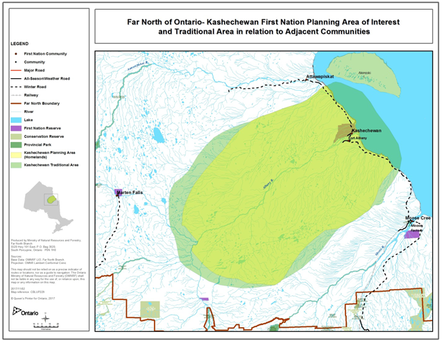
Planning area
Kashechewan First Nation has identified a draft Planning Area of Interest for the purpose of preparing a CBLUP. Kashechewan’s Traditional Land Use Area is approximately, 4,868,075 ha with an additional 365,000 ha that extends into coastal waters. The draft Planning Area of Interest is approximately 3,913,637 ha and is situated on the western coast of James Bay in the Far North.
The draft delineation of the KFN Planning Area of Interest can be found in Figure 1. It is based on a number of factors including, but not limited to the following.
- KFN’s extensive past and present connection with the lands and waters of its traditional and ancestral territory.
- Since 2008, ongoing ITK research and documentation through interviews has been conducted with many KFN community members, with specific efforts to capture ITK from Elders through land excursions, river trips and research on historical documents.
- Ongoing dialogue with the neighbouring communities will be sought to further refine and delineate the Planning Area of Interest, which is intended to reflect traditional, ancestral and shared lands interests.
KFN will also use its CBLUP to highlight its vast historical and contemporary connections with, and use of the adjacent islands and the James Bay waters. While these islands and waters are within the jurisdictional authority of Nunavut, and therefore land use planning for this area cannot be addressed under the Far North Act, Ontario understands the high value placed on these areas based on historical occupancy. These areas have been, and continue to be, used by KFN for a wide variety of traditional cultural practices, including hunting and fishing. Once the Final CBLUP is complete, KFN and Ontario will engage with Nunavut through a shared areas dialogue to establish KFN’s interests for these islands and the James Bay area in an effort to support KFN’s interests in building relationships with neighbouring jurisdictions to advance their respective planning interests.
Through ongoing dialogue and continued discussions with neighbouring communities, the draft Planning Area of Interest will be refined and then designated as a final planning area through a request for designation under a Minister’s order before the completion of the Final Plan.
Figure 1 - Kashechewan First Nation Planning Area of Interest and Traditional Harvesting Area
Shared Lands
KFN is committed to building and/or fostering relationships with neighbouring First Nations regarding the discussions for shared lands for the intended Planning Area of Interest. The goal is to work collaboratively with neighbours to understand their shared planning areas of interest and ultimately, planning intent. Neighbouring communities located adjacent to the KFN draft Planning Area of Interest include: Attawapiskat, Fort Albany, Marten Falls, Constance Lake and Moose Cree.
Also included are the islands and waters of western James Bay within KFN traditional territory outside of Ontario under the jurisdiction of Nunavut. KFN wishes to approach Nunavut to explore planning options available similar to those in place in Ontario under the Far North Act to ensure the continuance of traditional cultural practices and usage. Adjacent communities are shown on Figure 2.
Figure 2 - Kashechewan First Nation Planning Area of Interest and Traditional Harvesting Area in relation to adjacent communities
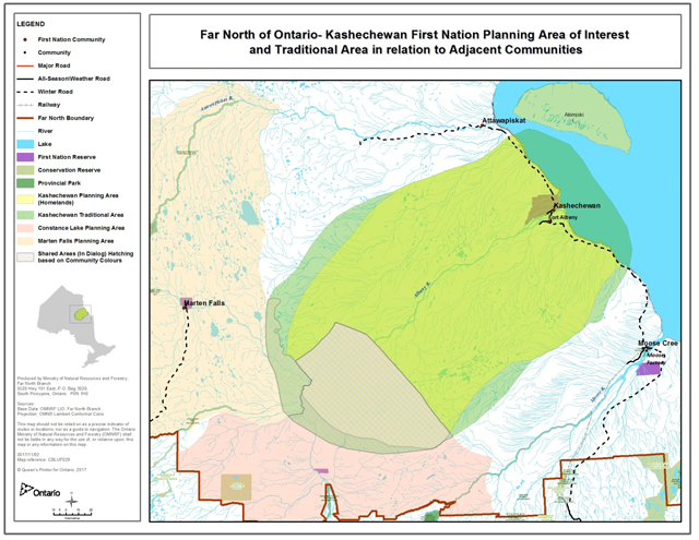
Through consistent and open dialogue with the neighbouring communities identified, shared lands interests will be addressed in a manner that is respectful to all communities involved. This approach should collectively address identified planning interests to then be incorporated into the planning process.
The following describes current understandings regarding shared lands with Fort Albany, Marten Falls and Constance Lake First Nations. We also anticipate future shared lands interactions with Moose Cree and Attawapiskat First Nations.
Fort Albany First Nation
An enhanced engagement agreement has been signed between FAFN and KFN, which outlines a process for including FAFN in KFN and Ontario’s planning process. A copy of the agreement is included in Appendix A.
Marten Falls First Nation
Kashechewan First Nation’s Traditional Harvesting Area coincides with Marten Falls First Nation’s Planning Area. Both communities will continue to share the area for traditional activities and do so with respect for each First Nation. There is an understanding that Marten Falls First Nation is leading planning in this shared area. Regular dialogue will be ongoing to share information and consider mutual planning interests.
Constance Lake First Nation
Kashechewan First Nation’s Planning Area of Interest and Constance Lake First Nation’s Planning Area coincide. KFN and Constance Lake First Nation are building consensus on land use designations for this planning area. There is an understanding that Constance Lake First Nation is leading planning in this area. Regular dialogue will be ongoing to share information and consider mutual planning interests.
Kashechewan First Nation’s Traditional Harvesting Area coincides with Constance Lake First Nation’s Planning Area. Both communities will continue to share the area for traditional activities and do so with respect for each First Nation. There is an understanding that Constance Lake First Nation is leading planning in this shared area. Regular dialogue will be ongoing to share information and consider mutual planning interests.
Planning subjects and outcomes
Planning subjects
Plan direction will define land use areas and policies to support or restrict activities on the land. This direction will be in the Final Plan for the Planning Area and will consider, but not be limited to, the following planning subjects.
Culture and heritage areas
- Identify burial grounds, culturally important landscape features, and significant cultural and/or spiritual gathering sites
- Document historical and current uses of the land and resources
Geoscience and mineral development
- Apply the best available geoscience information in support of the planning process
- Identify known mineral occurrences, existing mining lands, areas of high potential for metallic and industrial mineral deposits (and possible groundwater and energy resources) for present and future economic opportunities and community needs
- Identify areas available for mineral exploration, and development
- Identify potential natural geological hazards to help ensure community health and safety
- Identify the rate and potential impacts of Isostatic Rebound
Protected areas
- Designate one or more protected (preserved) areas
- Strive to create an interconnected network for ecological, traditional, and spiritual significance
- Identify sacred sites and apply for withdrawals under Section 35 of the Mining Act (Sites of Aboriginal and Cultural Significance)
- Consider adjacent planning area land use designations (if any) and possible effects on protected areas
Aggregates
- Identify existing and potential areas for extraction for community and/or commercial opportunities and infrastructure development
- Identify and protect access to significant aggregate areas for community use
Waterways
- Determine areas and their importance for cultural and spiritual meaning, drinking water sources, and recreational importance
- Assess fish population health and aquatic plant health
- Ensure drinking source water protection
Forestry
- Identify areas which are suitable for community use and commercial forestry activities, if any, including identifying appropriate harvest types in enhanced management areas
Non-timber forest products (NTFP)
- Identify land uses in which the community’s NTFP interests for traditional or commercial purposes may be pursued
- Identify important areas of natural medical sources from both land and water
Climate change
- Identify and understand current/emerging community threats and opportunities related to climate change
- Provide for flexibility, mitigation and adaptation for changing climactic considerations and the potential climate-induced effects on the land into the future
Infrastructure
- Identify existing and potential infrastructure corridors and water crossings to support future access needs for resource development, and community infrastructure such as power transmission, communications, all season roads etc.
- Consider infrastructure corridors in adjacent planning areas as part of the planning process
- Identify areas where access restrictions may be required to preserve remoteness while enabling economic activities
- Consider the compatibility of linear corridors, including electrical transmission lines, roads, pipelines and other linear developments, with other land features.
Tourism
- Identify potential tourism opportunities to support economic development including ecotourism, adventure tourism and other nature-based tourism opportunities
- Identify localized non-remote tourism opportunities
Renewable energy
- Identify and assess potential economic energy opportunities using the most accurate information available from both internal and external sources
- Opportunities to consider could include wind, water, biomass, solar and tidal energy
Existing uses
- As part of the planning process, existing uses will be identified and considered, where applicable (i.e., tourism, mining claims, infrastructure)
Oil and gas
- Identify potential oil and gas opportunities to support economic development.
Peat/carbon sequestration
- Identify carbon sequestration potential in the Planning Area of Interest
Horticulture
- Identify opportunities for horticulture activities in the Planning Area of Interest
Wildlife and plants
- Identify and protect aquatic and terrestrial wildlife, their habitat, and medicinal plant areas
- Consideration for Species at Risk and their habitat
Planning outcomes
Through the land use planning process, KFN and Ontario will collaboratively address land use interests to define land use designations suitable to KFN’s needs that will support social, economic, and environmental interests. Specific planning outcomes will include, but are not limited to the following:
- Documentation of the collected and analysed ITK to support and inform the planning process.
- Description and establishment of a designated planning area for KFN.
- Designation of one or more protected areas within the Planning Area of Interest.
- Defined planning goals and objectives to facilitate the implementation of the plan.
- Identification of a plan review period.
- Identification of land use designations for the Planning Area of Interest and the determination of what development, land uses and activities are permitted within each designation.
- Identification of how the plan has addressed significant cultural and spiritual features, values and land uses.
- Description of how the plan has addressed features and land uses adjacent to the planning area, and how KFN and Ontario wish to see these areas complement the directions of the plan.
- Documentation of ecological and economic concerns at local and landscape scales, and a description of how those considerations were incorporated into planning decisions.
- Consideration of how the land use direction of the Final Plan can support species at risk concerns, and biodiversity.
- Transparency through inclusion of supporting information used in planning decisions where appropriate.
- Guidance for subsequent plan implementation, including directing how both KFN and Ontario will work in collaboration to address subsequent land use planning decisions.
- Establishment of an understanding of how to proceed for the James Bay and the adjacent islands within KFN traditional territory but outside of Ontario’s jurisdiction.
- Identification of processes and funding mechanisms to implement planning decisions and direction
Land use planning responsibilities
Roles & responsibilities
KFN and Ontario are committed to working together as partners to complete and implement the Community Based Land Use Plan and future planning documents in good faith.
The Joint Planning Team is responsible for facilitating and leading opportunities for dialogue within the community to inform and support planning decisions as part of the planning process. KFN is also responsible for facilitating an understanding of ITK and land use of ancestral lands, to foster an increased understanding of these areas with appropriate stakeholders, researchers, interest groups, and the public.
The Ministry of Natural Resources and Forestry is responsible for representing Ontario during the planning process. MNRF helps to bring forward Provincial interests including economic development and conservation and is directly responsible for supporting the completion of a CBLUP in accordance with the Far North Act, 2010. MNRF has representatives working at the practical planning level and are involved as members of the JPT.
The following subheadings outline the roles and responsibilities of the various parties assisting in KFN’s CBLUP development process.
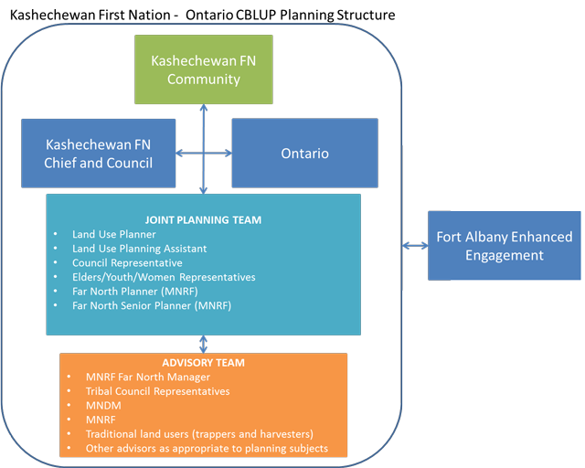
Joint Planning Team
The Joint Planning Team (JPT), which includes elders, is responsible for overall support to the community members regarding all CBLUP functions including the following.
- Facilitating planning team meetings, community meetings and Chief and Council briefings related to all aspects of the CBLUP process.
- Coordinating all of the best available and relevant information to support dialogue and decision making towards land use designations within the designated Planning Area of Interest.
- Drafting all information materials pertaining to CBLUP process, including the TOR, Draft Plan, Final Plan and amendment documents.
- Reviewing all available information collected from within the community, Ontario government sources, and external sources to support dialogue and decision-making efforts at each phase in the CBLUP process.
- Discussing and developing a jointly prepared CBLUP, in partnership between KFN and Ontario.
- Shared area/neighbouring communities dialogue supported by Chief and Council
The JPT is comprised of KFN and Ministry of Natural Resources and Forestry (MNRF) members. The composition of the JPT is as follows:
- KFN Planner
- KFN Planning Assistant
- 1 MNRF Far North Planner
- 1 MNRF Senior Planning Coordinator
- KFN Councillor
- 2 KFN Elders
- 1 Women’s Rep
- 1 KFN Youth Rep
Kashechewan First Nation membership
Through community engagement opportunities, community members are encouraged to learn about and engage in a leadership role in the CBLUP process. KFN members (including youth, women and men) are also encouraged to continuously share perspectives and knowledge and information to advise the JPT of considerations and interests, to support land use decisions to be incorporated into the draft and final plan.
Chief and Council
Chief and Council will offer guidance to the overall community based planning process and provide necessary political direction as required. Chief and Council may also choose to support opportunities for community engagement and input into land use decisions, as appropriate.
Chief and Council will also support or offer direction to the JPT in engaging neighbouring communities in shared areas dialogues. The objective for dialogue will be to establish a common understanding of land intent for areas that are common to the traditional heritage of more than one First Nation.
Traditional land users, trappers and harvesters
Community traditional land users, trappers, and harvesters have a vast wealth of information and knowledge of the lands and will be integral to providing expert insight on a variety of land use interests to support decision making.
This group may also play an important role in the cross-cultural dialogue to convey the significance of traditional use and knowledge with stakeholders, interest groups, and the public.
Resource support
MNRF Far North Branch will provide funding and resource supports for the planning process including First Nation staff, travel and meeting costs. These supports will be discussed and evaluated annually by the JPT.
Additional resource support from outside agencies, academia, and stakeholders may be called upon by the JPT at any time in the planning sequence to provide additionally required knowledge, information, or perspectives that may further support community dialogue and an enhanced understanding on a certain topic related to lands and waters.
The use of these additional information sources will provide the JPT with a more holistic perspective on the existing knowledge of the lands and waters to further assess and develop land use decisions for incorporation into the draft and final plan.
Enhanced engagement with Fort Albany First Nation
An agreement between KFN and FAFN was reached in February of 2017. This agreement outlines the interests of both communities for land use planning. Through the preparation of this TOR and the CBLUP, KFN will ensure that FAFN is engaged in a manner that is consistent with the agreement. A copy of the agreement is available in Appendix A.
Figure 3 - Planning structure
Planning stages and intended timelines
Planning initiation and engagement timeline: 2008-2009
- Gathering ITK
- Seek funding support and approval
- Council & Elder support for the process
Community Based Land Use Planning preparation timeline: 2009-2012
- Assemble Elders advisory group
- Assemble the Joint Planning Team
- Continue ITK gathering
- Gain a common understanding between KFN and Ontario with respect to planning objectives to begin structuring the planning process
Terms of Reference development timeline: 2012-2017
- Determine a draft Planning Area of Interest
- Describe objectives
- Assemble ITK data
- Communicate to develop awareness within the community membership
- Invite community members to participate
- Discuss shared areas of interest with neighbouring communities
- Develop Enhanced Engagement planning approach with Fort Albany First Nation
- Seek joint approval/endorsement of the TOR
- Share the TOR broadly, with invitation to participate to community members, adjacent First Nations, stakeholders, industry, other interest groups, and the general public through an Environmental Registry posting, newspapers, and mailouts.
- Hold one or more open houses in appropriate locations (e.g., the community and Timmins) to share the TOR, and available background information
Draft Community Based Land Use Plan projected timeline: 2017-2019
- Assess and analyze ITK and western science information
- Communicate with, and create awareness within community membership
- Invite participation from community membership
- Incorporate Enhanced Engagement planning approach with Fort Albany First Nation
- Prepare draft recommendations describing proposed Land Use Designations and associated direction for lands, waters and resources
- Identify and implement areas for interim protection and withdrawal from stacking
- Share draft plan for community membership comments, work with community members and Ontario to reach consensus on the draft plan
- Ensure involvement opportunity and share draft plan information with off reserve membership
- Identify traditional Cree names for waterways and landmarks
- Incorporate comments from information sharing, revise and share
- Hold discussions with neighbouring communities on shared lands of interest and proposed land use designations
- Share draft plan, invite comment and input from First Nation community members, adjacent First Nations, stakeholders, industry, other interest groups, and the general public through a second notice on the Environmental Registry, newspapers, and mailouts
- Hold one or more open houses in appropriate locations (e.g., the community and Timmins or Kapuskasing)
- Consider public input and offer response to comments
- Seek joint approval/endorsement of the draft plan
Final Community Based Land Use Plan projected timeline: 2019-2020
- Incorporate suggested changes into the Final Plan and ensure community and Ontario consensus
- Incorporate Enhanced Engagement planning approach with Fort Albany First Nation
- Seek Final Planning Area designation
- Post an Information Notice on the Environmental Registry
- Seek joint approval/endorsement of the Final plan
- Post notice of, and share the Final Plan (including decision notice) on the Environmental Registry
Plan implementation projected timeline: 2020-Onward
- Work in partnership to address implementation procedures consistent with the Final Plan
- Incorporate Enhanced Engagement planning approach with Fort Albany First Nation
- Review and amend CBLUP in accordance with scheduled timelines
- Continue ongoing information gathering, assessing, analyzing (ITK and Western Science)
Decision making and approvals
KFN and MNRF will utilize a consensus-based decision making approach throughout the planning process, including the preparation of the TOR, Draft and Final Land Use Plan documents. This process will be informed by the recommendations of the JPT.
The Far North Act identifies the requirements and authority for approvals of the TOR, final CBLUP, and planning area designation. Joint approvals for these are required by KFN Chief and Council (Band Council Resolution), Fort Albany Chief and Council (Band Council Resolution) and MNRF.
Decisions regarding the TOR, Draft and Final CBLUP will be documented in written records, which will be maintained and approved by both KFN and MNRF as part of the planning process.
Once a CBLUP is approved, provincial regulatory decisions on land use activities (allocation, disposition or use) and the activities themselves must be consistent with the land use designations and permitted land uses and activities specified in the plan. In addition, MNRF and other provincial ministries and agencies continue to have obligations set out in provincial policy and legislation.
KFN and MNRF will implement these TOR for a land use plan in good faith. During the planning process, new information and/or emerging direction may require an amendment to the TOR. In this event the planning team would prepare a recommended amendment.
Information management
KFN values and appreciates the importance of collecting, documenting and sharing knowledge today and also with future generations. It’s recognized and respected that time is of the essence in retrieving and documenting Elders’ knowledge and oral history. Great efforts have been and will be made, in preserving information for the purpose of sharing local history, cultural and traditional values with the community members, especially the youth. Products have been developed from previous information gathered to include: ITK work, film productions and other visual/audio products.
Information previously collected and information collected in the future from a variety of sources, will be continuously brought forward and considered to help support and inform the joint planning process. It will also serve as a major focal point of cultural interest as the basis for preparing land use direction, and planning and management decisions. This information will serve as the grassroots for the development of our CBLUP that is unique to KFN. The below description details how the community and MNRF establish what information will be brought forward by each partner and how it will be used, while respecting and protecting Indigenous Knowledge.
All indigenous knowledge used to support the planning process and decisions will remain with the community unless the community deems it shareable with the MNRF. This would particularily apply to sensitive areas the community does not want publicly identified.
MNRF will provide and support JPT with its best available information and data, to be used for the purposed of community based land use planning. In addition, the JPT will identify appropriate information management strategies for the information used to support the development of the CBLUP.
The JPT will ensure compliance with requirements for information under the authority of the Freedom of Information and Protection of Privacy Act, and the Archives and Recordkeeping Act, 2006. Notices required for consultation purposes under the Environmental Bill of Rights will be the primary responsibility of MNRF.
The JPT will oversee communications and delegate as required, including developing and ensuring public notices are submitted as required, compiling the appropriate mailing list, initiating mail out of planning phase information, providing notice of meetings, and any other information deemed appropriate.
MNRF and KFN will provide public notice of all supporting planning documents including the TOR, Draft Plan and Final Plan. All formal input and comments received during the planning process will be documented and available as an official planning record. Copies of all formal input and comments received during the process will be provided to the JPT.
Issue resolution process
The JPT shall work together to prepare the land use plan through a consensus-based approach. Where the team fails to reach consensus, issues not resolved through the JPT pertaining to the planning process can be addressed directly to the KFN Chief and Council and senior MNRF staff. The JPT may also seek advice from KFN elders, community members and provincial advisory groups in reviewing the issue.
Written records of all decisions pertaining to the CBLUP made as part of the planning process will be maintained and approved.
Contacts
Chief Leo Friday
Kashechewan First Nation
Phone:
Email: leo.friday@kfnation.ca
Michael Goodwin, Councillor
Kashechewan First Nation
Phone:
Email: mikegoodwin2015@hotmail.com
Edward Sutherland
Kashechewan First Nation
Land and Resources Coordinator
Email: edwardsutherland.kfn@gmail.com
Phone:
Grant Ritchie
Far North Director
Far North Branch, Ministry of Natural Resources and Forestry
Email: grant.ritchie@ontario.ca
Phone:
Roy Sidders
Far North Planning Manager
Far North Branch, Ministry of Natural Resources and Forestry
Email: Roy.Sidders@ontario.ca
Phone:
Rachelle Lalonde
Senior Planning Coordinator
Far North Branch, Ministry of Natural Resources and Forestry
Email: rachelle.lalonde@ontario.ca
Phone:
Appendix A - Enhanced Engagement Agreement
Agreement for the enhanced engagement of the Fort Albany First Nation in a Community Based Land Use Planning Project by the Kashechewan First Nation and the Ministry of Natural Resources and Forestry.
- The Fort Albany and Kashechewan First Nations have historic and current shared interests in the land around the two communities and along the Albany River.
- The Kashechewan First Nation is interested in leading a community based land use planning (CBLUP) project in partnership with the Ministry of Natural Resources and Forestry in the area shown on the attached map.
footnote * - The Fort Albany First Nation respects and supports the CBLUP and, while it does not wish to be a formal participant, wishes to ensure that the interests of its people are protected.
- The Kashechewan First Nation will take steps to ensure that the Fort Albany First Nation is able to participate in the CBLUP by agreeing to this protocol under which there will be enhanced participation by the Fort Albany First Nation which shall include:
- The incorporation of indigenous knowledge from the people of Fort Albany in the planning process based on information provided by the Fort Albany First Nation;
- Ensuring that all planning team meetings are open to representatives of the Fort Albany First Nation;
- The holding of regular joint meetings of both Chiefs and Councils concerning the development of a draft CBLUP;
- The holding of open house sessions in both Fort Albany and Kashechewan at which community members will be able to learn about the CBLUP and contribute to its development. It is anticipated that there will be a minimum of three sessions in each community;
- Participation by Fort Albany First Nation representatives in the development of the terms of reference, draft plan and final plan for the CBLUP; and
- Documentation in both the draft and final plans of the engagement of the Fort Albany First Nation in the CBLUP
- The Kashechewan First Nation recognizes that the enhanced engagement of the Fort Albany First Nation is essential for the successful completion of the CBLUP.
- The Fort Albany First Nation recognizes that the Kashechewan First Nation has a legitimate interest in the development of the CBLUP.
- It is anticipated that there will be a meeting to development and approve terms of reference for the CBLUP in April or May 2017.
- Each First Nation will indicate its support for the CBLUP through Band Council Resources at the Terms, Draft and Final Plan stages.
- This agreement is entered into on behalf of the First Nations by their Chiefs who, signing below, confirm the support of their Councils.

Chief Andrew Solomon
Fort Albany First Nation
Chief Leo Friday
Kashechewan First Nation