Killarney Provincial Park Management Plan
This document provides policy direction for the protection, development and management of Killarney Provincial Park and its resources.
Ministry of Natural Resources
Hon. Vincent G. Kerrio
Minister
Mary Mogford
Deputy Minister
Park Mmanagement Planning Series
Killarney Provincial Park Management Plan
MNR 3089
ISBN 0-7743-9487-0
© 1985 Government of Ontario
Additional copies of this publication are available for $5.00 at the Ministry of Natural Resources, Killarney Park, Killarney, Ontario, P0M 2A0, Telephone (705) 287-2368; Ministry of Natural Resources, Sudbury District Office, Box 3500, Station "A", Sudbury, Ontario, P3A 4S2, the Ontario Government Book Store, 880 Bay Street, Toronto, Ontario M7A 1N8
Approval statement
Killarney Provincial Park contains one of Ontario’s most magnificent natural landscapes. It has justly been called the jewel of the Ontario Provincial Parks system. We are most grateful to members of the public who made such a significant contribution to the planning of this remarkable park.
We are pleased to approve the Killarney Provincial Park Management Plan as official policy for the management and development of this park. The plan reflects this Ministry’s intent to protect natural and cultural features of Killarney and maintain and develop high quality opportunities for outdoor recreation and heritage appreciation for both residents and visitors to the Province.
Approved by:
N.R. Richards
Director
Parks and Recreational Areas Branch
M.A. Klugman
Regional Director
Northeastern Region
1. Introduction
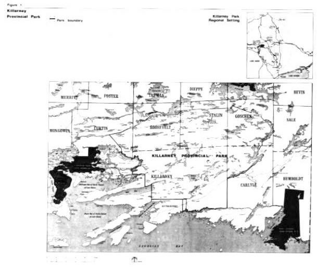
Killarney Provincial Park was established in 1964 to protect a significant section of the north Georgian Bay area for wilderness recreation pursuits. Today it comprises 48 500 ha situated on Highway 637,100 km south of Sudbury (figure 1). The park is administered by the Sudbury District Office of the Ontario Ministry of Natural Resources (MNR). It encompasses the eastern section of the La Cloche Mountains, which are regarded as a unique landform feature in the province. Among its other significant features are the range of rock formations found abandoned glacial lake beaches, ecologically stressed ridge habitats and prehistoric human occupation sites. Killarney was first recognized as one of Ontario’s finest scenic landscapes in the early 1900's by artists who could later form the Group of Seven. Today, the high white quartzite ridges and clear blue lakes provide an ideal setting for canoe tripping and backpacking.
The management planning program for the park was initiated in 1968. Planning alternatives were presented in 1972 in the 'Options for the Future document and public response prompted a reconsideration of park management proposals. A series of park studies was conducted including an economic impact assessment, recreation surveys on canoeing and hiking capabilities and use, and resource studies of earth science, life science and historical features. In addition, the feasibility of a road proposal to link Killarney with Whitefish Falls was commissioned by the Ontario Ministry of Transportation and Communications (CMIC) in 1978. The road proposal was found to be too costly a proposition on the basis of current information on social and economic circumstances.
The Sudbury and Espanola District Land Use Guidelines documents (DLUG, 1983) reaffirmed Killarney’s wilderness classification and recommended an extension of the park boundaries. The recommended area was added to the park on June 7, 1983 (O. Reg. 345/83). The 'Preliminary Management Plan' was presented for public review in August and September of 1984. A detailed account of the public comments and OMNR response is presented in the 'Public Participation Analysis'. The Killarney Provincial Park Management Plan provides policies that will guide the orderly development and effective management of the park over the next 20 years. These policies are based on the achievement of the goal and objectives of this wilderness park.
2. Park policy
2.1 Park classification
Killarney Park will continue to be classified as a wilderness park, one of six classes of Ontario Provincial Parks. It has several resource and recreational attributes that warrant this special designation. The focus will continue to be the La Cloche Mountains' environment and wilderness recreation pursuits. The retention of Killarney’s wilderness classification recognizes the increasing importance of accessible wilderness in today’s mechanized society.
The development and management of Killarney Park will adhere to the wilderness class guidelines as set out in the 'Ontario Provincial Parks Planning and Management Policies' and District Land Use Guidelines for Sudbury and Espanola. It will be managed to minimize human impacts so that natural processes can have the dominant influence on the landscape.
Some existing uses that occur in the park will be phased cut in a manner least harmful to the social and economic well being of the people who are involved (see resource management section).
Figure 1: Killarney Provincial Park

Enlarge Figure 1: Killarney Provincial Park map
2.1.1 Statement explaining classification
In the range of wilderness parks, Killarney will be developed and managed as a 'threshold wilderness park' because of its size, developed surroundings and proximity to large urban populations. This concept recognizes and reinforces the park' s present character, without trying to impose an extreme degree of wildness that does not exist. Situated on North Georgian Bay, one of Ontario’s most popular and accessible recreation areas, Killarney presents a less pristine condition than its larger wilderness counterparts such as Quetico and Polar Bear Provincial Parks. Killarney' s main contribution in the Ontario Provincial Parks system is to introduce visitors to their first real taste of a largely undeveloped, natural landscape. In this setting, visitors can gain an enjoyment and appreciation of wilderness, as well as the knowledge and skills to visit wilder areas.
As a threshold wilderness park, Killarney will contain a substantial wilderness core accessible from a few small development areas on the periphery. The core area will accommodate wilderness forms of recreation while the peripheral areas within the park will support a wider range of uses including camping at George Lake, boating on Baie Fine and resort accommodation ion at Bell Lake.
In this manner, the park will achieve its objectives for wilderness protection and use while accommodating more intense recreation and limited tourism uses on the park boundary.
2.2 Park goals
"To protect the Killarney Park landscape and provide for high quality wilderness recreation and nature appreciation in a wilderness park of special significance within the Ontario Provincial Parks system."
2.3 Park objectives
Protection
"To protect provincially significant elements of the natural and cultural landscape of Ontario."
To protect the eastern section of the La Cloche Mountains and associated drainage basins in an undisturbed natural condition. In so doing, the park will protect a representative portion of the ancient geological earth history and modern environments associated with the La Cloche Mountains.
Recreation
"To provide Provincial Park outdoor recreation opportunities ranging from moderate-intensity day use to low-intensity wilderness experiences.
To provide high quality backcountry travel, day use and car-camping opportunities. The main recreation emphasis of the park will be on the provision of canoeing and hiking. Including the entire park area, 51,700 backcountry opportunities will be available. In addition the park will provide 6,671 day use opportunities and 62,870 car-camping opportunities. Off-season use will be encouraged, including winter forms of recreation such as cross-country skiing and snowshoeing.
Heritage appreciation
"To provide opportunities for exploration and appreciation of the outdoor natural and cultural heritage of Ontario."
The visitor services program will provide information and opportunities for visitors to discover and learn about the character and significance of the park.
Tourism
"To provide Ontario residents and out-of-province visitors with opportunities to discover and experience a distinctive region of the Province."
Tourism use will be permitted to the extent that is possible without adversely affecting the park environment or visitors' experience.
Limited tourism development that complements the protection and recreation objectives may be considered in access zones along the park periphery.
2.4 Park zoning
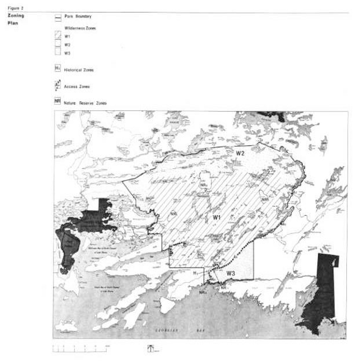
The lands and waters within Killarney Park have been zoned so that they may be allocated to their most appropriate use (figure 2). There are access zones, wilderness zones, nature reserve zones and historical zones.
Figure 2: Zoning Plan Map
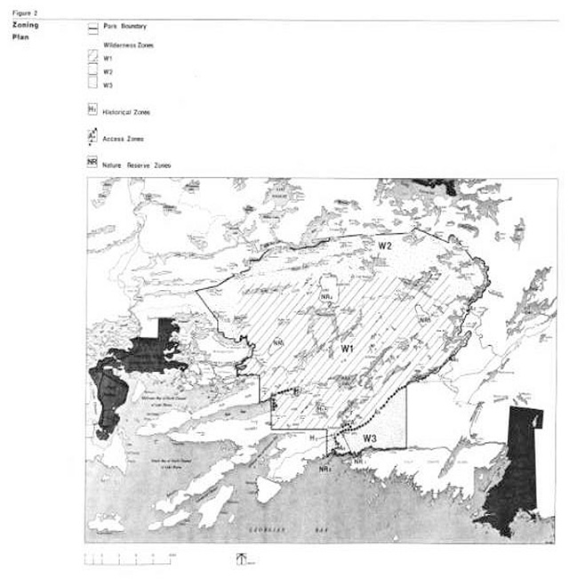
EnlargeFigure 2: Zoning Plan map
2.4.1 Access zones
Access zones will direct wilderness use to the park interior. Some access zones will also function as wilderness initiation areas containing facility-based camping and day use. At these locations, visitors will be exposed to threshold wilderness experiences through visitor services programming and by self-guided day use hiking and canoeing into adjacent wilderness zones. Development in access zones may include roads, parking facilities, visitor control structures, car or boat-in campgrounds, and orientation, interpretive, research and management facilities (see development section).
George Lake access zone - A1 (22 hectares)
The George Lake access zone will contain the main facility concentration comprising a car campground, interior canoeing access and park office. Existing facilities will be redesigned and upgraded and some additional facilities will be developed. The car campground will be expanded from its present capacity of 38,477 opportunities to supply a maximum of 62,870 car camping opportunities.
Bell Lake access zone - P.2 (2 hectares)
The Bell Lake access zone will be developed to provide interior canoeing and hiking access to the W2 zone. By improving access to the park' s moderately used northern and eastern waterways, the P2 zone will facilitate a mare equitable distribution of canoeing use and reduce the heavy demand on the southern likes.
Johnnie Lake access zone - A3 (1 hectare)
The existing access point on Johnnie Lake will continue to provide canoe access. The site will be upgraded. The adjacent Carlyle Lake access point will no longer be used for canoe entry but will continue to provide a motorboat launching site for cottagers.
Highway 637 Access Zone - A4 (150 hectares)
The A4 zone that encompasses the Highway 637 corridor will provide hiking trail access to both the Wl and W3 zones. The highway right-of-way will continue to he managed by OMTC. OMTC will be encouraged to maintain the roadside in a manner that compliments park objectives.
Chikanishing Creek and Collins Inlet Access Zone - AS (2 hectares)
The AS zone will continue to provide boating access to Collins Inlet, a popular boating and fishing area. The zone will also provide year-round trail access to the W3 zone. The existing road and parking area will be upgraded to accommodate vehicles for boaters and those using the trail network.
Baie Fine Access Zone - A6 (2 hectares)
The A6 zone will continue to provide anchorage for yachts and sailboats on the Great Lakes along with interior canoeing and hiking access to the Wl zone. Day hiking along the adjacent quartzite ridges is a popular activity among boaters. Background information will be collected to assist in the management of this zone.
Adjacent Access - Highway 6
Canoeing and hiking access to the park will be provided from the Highway 6 corridor. Primary consideration will be given to utilizing existing commercial and public access facilities. Minor park access facilities will be developed as required to ensure an adequate provision of access opportunities to the park.
Due to the predominance of patent arid surrendered Indian lands in the area, the establishment of an access point may require an easement or land acquisition. Possible locations include Willisvilie and Frood Lake. No park access development will occur on the east end of the McCutcheon road at Iroquois Bay.
2.4.2 Wilderness Zones
Wilderness zones include the wilderness landscapes of the park which protect significant natural, cultural and recreational facilities arid are suitable for a wilderness experience.
Development will be limited to the absolute minimum required to facilitate interior travel such as wilderness campsites, portages, trails and necessary signs for route identification.
La Cloche Mountains Wilderness Zone - W1 (30 035 hectares)
The W1 zone covers the park area north of Highway 637 to the north ridge of the La Cloche Mountains. The quartzite ridges and clear lakes of this zone best examples continue to be the main attraction for visitors. This zone offers good canoeing and excellent trail and off-trail hiking. The Wl zone will be developed and managed to provide the highest quality wilderness experience in the park. Necessary management controls will be implemented to ensure the achievement of the park’s protection, recreation and heritage appreciation objectives.
The canoeing capability to provide 34,100 opportunities in the zone has been largely realized and only minor expansion of campsites and portages will be permitted. The hiking trail capability has only been partially developed. The trail network, including hiking and cross-country ski trails will be completed.
Substantial ridge sections will remain undisturbed in order to maintain the wilderness quality and provide off-trail ridge hiking. This activity is recognized as the highest quality wilderness experience that is offered in the park. Development will be limited to a small number of isolated campsites. Trail development will not be permitted in the following areas: along the Blue Ridge from the Baie Fine hiking trail to the Silver Peak hiking trail; in the Gulch Hill area; and along the ridges north and east of Nellie Lake.
Boundary Waters Wilderness Zone - W2 (13 800 hectares)
The W2 zone comprises that portion of the park that was added to the area in 1983. Its dominant feature is the connecting waters of the Mahzenazing River and Howry Creek drainage basins. The zone offers extensive canoeing opportunities, as well as limited off-trail hiking along the ridge section south of the Howry Creek system. As this area was previously out of the park, there are a number of other recreation uses that occur here. These are addressed in the resource management section. The W2 zone will be developed and managed primarily as a canoeing area.
The canoeing capability of the zone has been only partially developed. Canoeing inventory studies indicate that good potential exists to provide the 17,600 additional canoeing opportunities required in the park
Georgian Bay Shoreline Wilderness Zone - W3 (3 155 hectares)
The W3 zone covers most of the park area south of Highway 637. The zone’s major feature is its rocky shoreline, which typifies Georgian Bay' s northern coast. The zone’s moderate relief and reddish bedrock outcrops contrast vividly with the high, white quartzite ridges to the north. The W3 zone will be developed to provide year-round trail opportunities. It will be managed primarily as a day use recreation area with interior camping limited to a few designated sites.
2.4.3. Nature Reserve Zones
Nature Reserve zones include significant earth and life science features which require management distinct from that in adjacent zones. The priority for nature reserve zones will be protection and research. Minimal interpretive, research and management facilities may be provided subject to prescriptions that will be prepared for each zone in the park operating plan.
The following descriptions highlight the significance of each zone.
Nipissing Shoreline Nature Reserve Zone - NR1 (30 hectares)
This zone contains a raised shoreline of glacial Lake Nipissing. It comprises a sand ridge that crosses Highway 637 just south of the George Lake campground.
Chikanishing River Nature Reserve Zone - NR2 (2 hectares)
This zone includes a glaciolacustrine deposit on the east bank of the Chikanishing River. This deposit consists of a thick sequence of laminated clays. Further research is required to substantiate the significance of this site.
Silver Peak Nature Reserve Zone - NR3 (305 hectares)
This zone possesses an extensive example of the extreme environmental conditions that characterize the barren sections of the quartzite ridges. It also has one of the most spectacular lookouts in the park.
Moose Pass Ridges Nature Reserve Zone - NR4 (551 hectares)
This ridge and valley area provides excellent representation of the main vegetation patterns from wetland valley bottoms to oak and pine ridge tops.
Great Bog Nature Reserve Zone - NR5 (300 hectares)
This wetland has a history of flooding and drainage. It is significant for its representation of the peat land types found in the area.
2.4.4. Historical zones
Historical zones include significant archaeological and historical resources of the park, which require management distinct from that in adjacent zones. The priority for historical zones will be protection and research. Subject to the management prescriptions that will be prepared for each zone in the park operating plan, minimal interpretive, research and management facilities may be provided. The following descriptions highlight the significance of each zone.
George Lake and Chikanishing Creek Historical Zones - Hi and H2 (43 hectares)
Both zones contain provincially significant archaeological sites The George Lake quartzite quarry was first occupied 9,000 years ago. Large quantities of quartzite tool implements were excavated there. The Chikanishing site contains several occupations beginning 6,500 years ago. The last occupation was 3,800 years ago.
Baie Fine Historical Zone - H3 (100 hectares)
This zone includes the former base camp of the Spanish Lumber Company that was used to log Killarney Township from 1908 to 1927. The caretaker' s camp and the company store still exist and are presently being used as private summer cottages.
3. Resource Management
Resource Management of Killarney Provincial Park will be carried out in accordance with the park management plan. A park operating plan will be prepared in keeping with the direction provided in the management plan. The operating plan will comprise specific operational guidelines on bow to carry cut the management of the park’s water, land, natural and cultural features.
3.1 Water
The occurrence of natural self-sustaining fish populations is recognized as an integral component of aquatic ecology. Due to acid rain, the park lakes are suffering from a water chemistry problem that has adversely affected fish populations. An on-going research program will be encouraged to monitor and quantify future changes and trends in water quality.
3.1.1 Water quality
Although the natural recovery of the park lakes is preferred, water quality improvement projects may be permitted when it can be demonstrated that treatments can be successfully applied without harmful side effects. These projects will be initially tested on a small scale. Should natural or artificial rehabilitation of the park lakes occur, it will be followed by a stocking program to re-establish indigenous fish species.
3.1.2 Sport fishing
In those water bodies containing viable fish populations, restrictive regulations may be established as required to ensure their continued survival.
Season length and catch limits may be set and certain water bodies may be closed to fishing temporarily or permanently for fisheries research or management purposes.
3.1.3 Dams
Four existing dams maintain artificial water levels for cottaging on Three Narrows Lake, Johnnie Lake and Carlyle Lake; swimming on George Lake and canoeing en Freeland Lake. As their removal would cause an adverse environmental impact, all four dams will be maintained. No new water control structures will be built.
3.2 Flora
The management of flora will be directed to maintain an evolving natural succession.
3.2.1 Tree removal
Commercial forest operations will not be permitted. Trees may be selectively removed for the purpose of constructing interior management facilities such as walking bridges and corduroy paths. As well, old or damaged trees may be removed when they present a safety hazard. The removal or addition of vegetation for wildlife habitat improvement purposes will not normally be permitted. The existing tree plantation along Highway 637 will not be tended and as such species composition will change naturally over time.
3.2.2 Fire
The occurrence of natural fire in a wilderness environment is recognized as an integral component of natural succession.
As Killarney is a relatively small wilderness park, allowing a natural fire to run its course will not normally be desirable except where prior study has delineated a particular site that would benefit from fire. In such a situation, a natural fire could be allowed to burn under supervision unless it threatens human life, park and private property or lands outside the park.
Fire suppression techniques will have as minimal an effect as possible on the wilderness environment. Aircraft will continue to be used for fire detection and control.
3.3 Fauna
The management of fauna will be directed to maintain an evolving natural succession.
3.3.1 Hunting, baitfishing and trapping
The existing hunting, baitfishing and trapping, which is confined to the W2 zone, will be managed in the following manner. Hunting will be permitted in the W2 zone until May 1, 1990. The two baitfish licences will be permitted to operate until May 1, 1990. The five registered trappers, with portions of their traplines inside the park, will be permitted to continue trapping. However, the transfer of that portion of their traplines in the park and construction of additional cabins will not be permitted. In this manner, trapping will be retired from the park through attrition.
3.3.2 Animal control
Animal populations may be controlled when essential to protect human health and safety and the park environment or the health of the species outside the park, i.e. overpopulation and epidemics. Where control is desirable, techniques will be used that have a minimal effect on other components of the wilderness environment. Nuisance animal control will only be directed at the culprit animal. Live trapping or drug injection will be the normal control measures used to relocate the animal away from the problem area. In situations where these measures are not feasible, the animal will be destroyed. Any hunting or trapping required in animal control will be carried out under the strict supervision of, or directly by, OMNR.
3.4 Land management
The management of land will be directed towards the provision of a natural landscape free from the modifying impacts of man.
3.4.1 Patent properties
The 40 patent properties within the park boundaries, excluding the Highway 637 right-of-way and the two existing commercial establishments, will only be acquired as they become available and when funds permit. This does not, include the patent properties on Johnnie and Carlyle Lakes that are outside the park. Existing mechanized means of access to patent properties will be permitted until the properties are acquired.
Acquisition priority will be given to isolated parcels over the more developed areas in order to confine patent properties to as small an area of the park as possible.
Conversion of the existing patent properties to commercial uses will not be permitted. In addition, the Ministry will discourage the conversion of the summer resort lots to commercial status on Johnnie and Carlyle Lakes. Alternate means of control will be examined prior to implementing the one that best achieves this purpose. Further land use controls may be considered in the plan review process as required to maintain the existing level of development on these lakes.
3.4.2 Land use permits
There are 13 land use permit (LUP) holders in the park. Camps under LUP will be permitted until May 1, 1990. Those LUP's associated with patent properties within the park may be permitted until such time as the patent is acquired. Prior to the cancellation of the LUP's, the permit holders will be given sufficient notice to remove their improvements.
3.4.3 Mining claims
There are 8 mining claims in the park. The claim holders will he permitted to continue their normal operations. Mining claims will be retired from the park, as they become available.
Road access to the claims will not normally be permitted except where existing access is inadequate to allow for the development of a significant mineral deposit. In such a case, a route location would be selected that has the least impact on park values.
3.4.4 Gravel pit
One gravel pit, known as the "Tyson Pit", is in operation to supply OMNR and Killarney village requirements. The pit located adjacent to Highway 637, will remain open until 1991 under the terms of the agreement with the Township of Rutherford and George Is land. The pit may be closed prior to that time if an accessible alternative source of gravel outside the park is located and developed. The site will be rehabilitated upon closure.
3.5 Cultural resources
The management of cultural resources will be directed to protection and heritage appreciation. Archaeological and historic sites and buildings will be identified and evaluated in co-operation with the Ontario Ministry of Citizenship and Culture. Development of archaeological sites will not be permitted with the exception of temporary research facilities. The precise location of the sites will not be advertised in order to protect them from human impact. Offsite interpretation may be provided and special interest groups may be permitted to visit the sites when accompanied by park staff. The historical significance of all acquired properties will be assessed. Where a structure or building has historical value, consideration will be given to its reconstruction or restoration with an eye to functional needs for future park purposes. Where historically significant features are privately owned, the Ministry may encourage the property owner to preserve them.
4. Client services management
Client services will be managed in accordance with the park management plan. A park operating plan will be prepared in keeping with the direction provided in the management plan. The operating plan will comprise specific operational guidelines on how to carry out client services management.
4.1 Visitor services
Visitor services programs will orient park visitors to the wilderness attributes of the La Cloche Mountains, the north Georgian Bay landscapes and cultural development. Visitor services program planning will emphasize personal contact and self use approaches to deliver park information, resource interpretation arid recreation skills programming.
4.1.1 Park information
A high quality public information service will furnish car campers and backcountry visitors with accurate information about park resources and interior travel. This knowledge will enhance their ability to safely explore and appreciate the park. A 'leave no trace' attitude will be practiced in order to minimize human impact on the park environment. Park literature will also direct visitors to attractions and services outside the park to enrich their experiences and generate local tourism expenditures. Information will also be provided on similar provincial parks to encourage visitors to further their wilderness experiences.
4.1.2 Resource interpretation
Interpretive programs will provide opportunities for visitors to learn and experience the wilderness character and resource significance of the park. The interpretive emphasis will be directed towards Killarney’s wilderness qualities.
The park story will he interpreted for the visitor through the use of "the land, the water and the people" theme.
This broad theme comprises the following sub-themes: "geology of Killarney"; "life in the barren rocklands"; and "wilderness and man’s response to it". Due to the visible effects of bedrock in shaping the park environment, the geological sub-theme will receive priority. Biological adaptations to the bedrock influences are a natural extension to the geological story. The cultural sub-theme involves man’s relationship with and response to the Killarney landscape from prehistoric times to the present.
These include actual sites of several works of art by The Group of Seven whom were instrumental in the development of Canadian wilderness landscape art. Historic and present day activities of Killarney village will he included as part of this story. Innovative ways of co-operative portrayal of this broad heritage of resources will be pursued with other agencies and institutions.
4.1.3 Recreation skills
Recreation programs will inform park visitors about recreational attributes of the park and the skills required in minimum impact wilderness travel. With improved recreation skills, visitors will make better use of the park arid will more fully enjoy themselves.
4.2 Recreation management
The management of recreation will be directed to the provision of a high quality wilderness experiences. Backcountry travel, such as canoeing, hiking arid low intensity camping are traditional wilderness pursuits where solitude, challenge and personal integration with nature are derived from the expansive landscapes of the park.
4.2.1 Recreation activities
Recreation activities permitted within the park will involve primarily wilderness forms of backcountry travel such as canoeing, trail hiking, off-trail hiking, snowshoeing and cross-country skiing with compatible associated activities such as camping, photography and viewing. Excluding access zones, the existing mechanized activities will be phased out of the park.
Motorboating will not be permitted in the park except as follows: on Baie Fine; for the use of patent property owners to access their properties until they are acquired; for the use of the two existing commercial establishments in the park; for the use of excluded property owners on Carlyle and Johnnie Lakes; for the use of registered trappers for accessing their traplines; and in the W2 zone until May 1, 1990 with the exception of the following lakes where motorboats with a maximum motor size of 1.5 kw (2 h.p.) will be permitted after that date - Hanwood, Van Winkle, Van, Grow, Pocky, Goose, Pound Otter, Little Mink and Cat Lakes. Consideration will be given in plan review to establish further motorboating controls on presently excluded lakes, including lake closures, and restrictions on motor size. In addition, controls may he considered on the number of boats allowed to enter and anchor in Baie Fine.
Snowmobiling will not be permitted except as follows: for the use of property owners and trappers in accessing their properties and traplines; in the W2 zone until May 1, 1990 with the exception of the following trails where it will be permitted after that date - the existing trail that skirts the park along Murray, Hanwood and Van Winkle Lakes, and along the designated snowmobile trail in the W3 zone. Snowmobiling along the designated trail south of Highway 637 will be permitted because of the lack of snowmobiling areas available to the local inhabitants of Killarney village. Snowmobiling along the Murray-Hanwood-Van Winkle trail will be permitted as it provides the only winter access from Willisville to the area north of the park. No other snowmobile trails will be permitted.
Aircraft landing by patent property owners in the park to access their properties nay he permitted under the authority of a valid aircraft landing permit issued by the park superintendent.
Restricted vehicle use by patent property owners in the park may be permitted along the Kakakise road and Three narrows-Baie Fine all-terrain vehicle route under the authority of vehicle permit issued by the park superintendent.
4.2.2 Use controls
Controls on recreation activities are required to protect the park environment from inappropriate uses and overuse, to ensure that visitors enjoy high quality wilderness experiences. Visitor services programs will be provided for park visitors to develop skills arid ethics of wilderness travel.
Restrictions will continue to be placed on the number of parties allowed to camp in the interior. In this way, visitors are distributed to keep levels of use more uniform in the park.
The existing quota system will be revised to provide visitors with a greater choice of travel routes once they enter the park.
A length-of-stay restriction on interior camping ray he established in heavily used areas to achieve a greater turn-over thereby enabling more visitors to enjoy these areas without increasing impact. Group use will be monitored and restrictions may be established as required to protect the park environment arid the experience of others. A maximum of nine persons will be permitted to camp on a campsite. In areas where firewood is in short supply or during periods of extreme fire hazard, visitors may be required to carry portable stoves.
A quota may be placed on the number of day use canoeing parties allowed in the Wl zone beyond George Lake. This measure would impose a level of control on day use activities similar to those on interior camping to reduce crowding on Killarney and O.S.A. Lakes.
Low level recreational flying over the park that is hazardous or which causes excessive noise intrusion will be controlled by the appropriate federal authorities through the existing regulations governing aircraft use. The Ministry will assist the federal authorities as required to ensure adherence to these regulations.
4.2.3 Facility management
Overused facilities will be rehabilitated or temporarily closed to allow natural recovery. Measures may involve the alternate closure of campsites, re-routing of trail and portage sections, as well as the construction of stairs, bridges, corduroy paths and docks. These facilities will
be kept to the minimum that is required for
travel purposes to protect the park environment.
4.3 Commercial services
There are two commercial establishments within the park: an outpost camp of Killarney Mountain Lodge on Johnnie Lake; and the Blue Mountain Lodge on Bell Lake. These existing establishments will be allowed to remain in the park. Their operation will be encouraged to occur in a manner that can be integrated with the park objectives. Additional commercial tourism development that complements the park may be considered in access zones only.
4.4 Marketing
Additional interior hiking and off-season use will be encouraged at Killarney. This involves overnight trail hiking, fall canoeing, cross-country skiing and snowshoeing. The promotion of these presently under-utilized activities could significantly contribute to the local economy, especially during the off-season. A key ingredient in increasing off-season use is the establishment of a good promotional program and the development of quality facilities (see development section). T~ facilities that will play an important role in this regard are the orientation centre and the heritage centre. In addition to these centres, supportive development will be required such as the up-grading and completion of the hiking trail network arid the provision of groomed cross-country ski trails.
Consideration will be given to a co-operative area marketing strategy in conjunction with the Ministry of Tourism and Recreation, local business people and tourist associations. Such a strategy would co-ordinate the marketing of attractions and services in the entire Killarney area, which include the park, the village, Highway 637 and the adjacent Georgian Bay and North Channel areas. The strategy would cover both peak season and off-season use. Peak season emphasis for the park would encourage summer park visitors to visit area attractions outside the park. Off-season emphasis would be directed at increasing visitation to the park and local facilities.
4.5 Research
Scientific research by qualified individuals that contributes to knowledge of natural and cultural history and to environmental and recreation management of wilderness will be encouraged in the park. Emphasis on research will be directed at determining the effects of acid rain on park soils, vegetation, wildlife and water. Fire ecology studies will also be encouraged.
All research programs will require OMNR approval and must also meet all requirements under applicable provincial and federal legislation.
5. Development
The location, design and materials of all facilities constructed within Killarney Park will, to the furthest extent possible, reflect it’s wilderness character. All development will be carried out in accordance with approved site and development plans. Once a development is in place, it will be managed in accordance with the operating plan. The following facilities will be proposed through work program planning and special funding initiatives (figure 3).
5.1 Park sign system
A sign system will be established to provide a consistent identity and co-ordinated approach to inform and direct visitors to facilities and services offered in the park. This will involve upgrading provincial highway signs as well as provincial park signs. The Ministry will work with OMTC to comply with their guidelines in the case of signs along Highways 6 and 637.
5.2 Visitor orientation centre
The centre, comprising a building and parking area, will be situated at the junction of Highway 637 and the Bell Lake road. It will function as both a tourist information centre and backcountry use control point. Support facilities will include a lookout trail arid viewing platform to introduce first time visitors to representative scenery of the area, including a view of Silver Peak.
The centre will serve as the control point for all park interior use originating from Highway 637. Interior camping permits for canoeing and backpacking will be issued at this location. Car camping permits will continue to be issued at the George Lake campground gatehouse. In addition, visitors will be informed about park resources along with the attractions, facilities and services available in the local area. The centre will also provide information on other wilderness areas throughout Ontario where visitors can further their experiences. A variety of communications methods will be employed including travel counseling, publications, displays and audio - visual productions.
Figure 3: Zoning Plan Map
Enlarge Figure 3: Zoning Plan map
5.3 Heritage centre
A four season heritage centre will be constructed in the George Lake campground to meet the objective of heritage appreciation to better serve park visitors. This multipurpose building will contain a large activity area, staff work space and washroom facilities for the travelling public and campground guests.
The centre’s primary role will be to encourage off-season use. Displays will present the main interpretive themes including geology, early man' s history and the Killarney village story. A highlight of the centre will be an exhibit dedicated to the Group of Seven whom were instrumental in the establishment of the park. Design requirements to achieve this end will be reviewed with appropriate agencies. The centre will accommodate hiking and canoeing demonstrations in the summer and serve as a cross-country ski chalet in winter.
5.4 George lake campground redevelopment
A redevelopment plan has been approved to redesign the campground entrance, upgrade campsites and main roads. As well, it details construction of a new gatehouse, additional campsites, an outdoor amphitheatre, a group camping area, washroom facilities and the heritage centre. The campground expansion is necessary to meet the targets for additional car camping opportunities in the park.
The park will be operated more efficiently with upgraded and new facilities which will result in year round park visitation to complement services that are available in the Killarney area.
The redesigned campground entrance will provide better vehicular circulation and additional parking space at the gatehouse. The existing campground with 122 campsites will be expanded to a maximum of 200 sites to provide the additional camping opportunities to meet recreation needs. The expansion will be developed in two separate stages with an assessment undertaken following the first stage to determine whether the second stage is required and can be established without adversely affecting neighbouring wilderness zones.
5.5 Interior access
5.5.1 George Lake
The interior access canoe launch site will be redesigned and upgraded to improve circulation arid reduce congestion. The parking area will ultimately provide space for 75-100 vehicles to accommodate the expanding backcountry use of the park.
Access facilities for interior trail hiking will he relocated to the Highway 637 corridor. This measure will reduce congestion in the Al zone and will separate campground nature trails from interior hiking trails.
5.5.2 Highway 637
Two access points containing parking areas, vault toilets arid approach paths to the main interior hiking trails will he developed along the highway corridor. A parking area and day use interpretive trail will also be developed for the Sinkhole Bog.
5.5.3 Bell Lake
An access point will he constructed at the south end of Bell Lake. Facilities will include a parking area for 50 vehicles and a canoe launch. The Bell Lake road has been upgraded and extended beyond Bell Lake bet will be used strictly for timber extraction north and east of the park and will be closed to public vehicular traffic.
5.5.4 Highway 6
A small park access facility is required to provide interior canoeing and hiking entry f ran the Highway 6 corridor. This facility is needed to serve as an alternate entry point to the now expanded park. Development will include a registration permit dispensing booth, a parking area, vault toilets and access to park canoe routes and interior trails.
5.6 Canoe routes
As well as upgrading routes in the W2 zone to provincial park standards, a northern canoe route will be developed from Murray Lake north to Leach and Hanwood Lakes and eastward to Van Winkle, Van, Grow, Rocky, Goose, Pound Otter and Fish Lakes. Portages arid campsites will be constructed along this route as demand dictates and priorities permit. The development of these northern routes will substantially increase the canoeing capacity of the park to provide an additional 17,600 opportunities for backcountry travel.
5.7 Interior trails
5.7.1 Hiking trails
An additional 50 kin of trail and accompanying campsites will be developed in the WI zone. Once completed, the new trail section will connect with the Baie Fine and Silver Peak hiking trails to form a 100 km long distance loop trail. New' trail linkages will be constructed to access points the Highway 637 access zone. The bypassed section of the Baie Fine hiking trail, from the campground to Lumsden Lake, will form part of a nature trail that will be constructed for campground visitors. The bypassed section of the Silver Peak hiking trail, from the Cranberry Bog nature trail to the new trail link, will be closed. A west trail extension will be developed to connect the park trail system with the Highway 6 corridor access point. Trail development will recognize the private lands west of the park and may necessitate obtaining agreements for use with landowners. A further connection outside the park may be developed with the proposed Voyageur Trail, which may ultimately extend from Manitoulin Island to Thunder Bay.
A trail network will be developed in the W3 zone to provide opportunities for nature walks, hiking and cross-country skiing. Campsite development for the zone will be limited to the longer trails and shoreline areas, the latter serving both hikers and canoeists.
5.7.2 Cross-country ski trails
Trails will be initially developed on a small scale and expanded as demand warrants and policies permit. Development will concentrate around the George Lake and Chikanishing Creek areas. To minimize the environmental impact of trail development, the existing hiking trail system will be used where possible for skiing. In this way new trails can be used for hiking in the summer.
5.8 George lake office and maintenance centre
The temporary park office and trailer staffing quarters will be replaced by a permanent park office and a 24 man staffhouse. The park superintendent' s trailer residence will be removed. A home will be purchased or built in the village of Killarney for the superintendent. The work yard will be improved to include an outdoor storage and work area complete with a cold storage shed and a flammable liquid storage shed. In addition, the 24 man junior ranger camp, comprising a cookery and bunkhouse, will be relocated away f ran the work yard.
6. Plan implementation and review
6.1 Plan implementation
Implementation of the management plan will involve the preparation of an operating plan, use controls and development of approved facilities. Work program planning and funding proposals will be based on the implementation of these aspects of the plan over the next 10 years.
6.1.1 Management planning
A park operating plan will be prepared to provide specific guidelines on the operational aspects of the various park programs. Park research will be encouraged in the future with priority given to the following areas of park interest:
- aquatic and terrestrial flora and fauna baseline research to determine vegetation arid wildlife resource characteristics of the park
- ongoing research to monitor arid quantify future changes arid trends in water quality relative to acid rain concerns
- Precambrian and quaternary geology research to determine the processes and origins of the formations and features within the park
- assessment of park landscapes and structures to determine their cultural significance
- monitor park use and prepare visitor services
6.1.2 Use controls
The following measures will be implemented by the dates as specified below:
- hunting, land use permits and commercial baitfishing activities will be prohibited in W2 zone by May 1, 1990
- motorboating and snowmobiling will be prohibited in W2 zone by May 1, 1990 except for those exceptions noted in the recreation management section
- Tyson gravel pit in A4 zone will be closed by May 1, 1991
6.1.3 Facility development
Approved development will proceed in the following operational categories. Within each category, items are ranked in order of priority.
Park interior
- major canoeing and hiking access point at Bell Lake
- visitor orientation centre at junction of Bell Lake road and Highway 637
- interior hiking trail
- access points along Highway 637 corridor
- completion of interior hiking trail system involving an additional 50 km of trail
- west park hiking and canoe access points off Highway 6 corridor
- development of northern canoe route connecting the lake system from Murray Lake eastwards to Fish Lake
- development of multipurpose trail network in W3 zone
- signage along Highway 637 and 6
- signage of park boundary
- completion of cross-country ski trail system
George Lake campground
- heritage centre building at George Lake campground including display area, large washroom facility arid showers
- redesign the campground entrance and canoeing access at George Lake involving new entrance road and gatehouse
- George Lake campground expansion (west portion) involving 32 campsites, three sets of vault privies, group camping area and amphitheatre
- George Lake campground expansion (east portion) if required at some later date. It would involve 66 campsites, two sets of vault privies and one comfort station with showers
Office and maintenance area
- park office at George Lake
- park staff house at George Lake
- construction or purchase of a borne in Killarney village for the park superintendent’s residence
- relocation of junior ranger camp
6.2 Plan review
The Killarney Provincial Park Management Plan will be reviewed on an ongoing basis throughout its 20 year lifespan. The review will be conducted in the following manner:
- review of the process leading to the initial management plan
- update of background information and data about the park resources and use
- review the status of implementation of the approved management plan and provincial policies
- identify C~1NR, other agencies and public issues of concern
- prepare issues and suggested solutions document for public review
- review proposed revisions recommended by the public
- prepare and receive approval for plan amendment
Selected references
Andrews, R.W. Recreational Resource Analysis of Killarney Provincial Park. Unpublished report, CI4NR, Sudbury: 1975.
Beamish, R.J. Loss of Fish Populations from Unexploited Remote Lakes in Ontario, Canada as a Consequence of Atmospheric Fallout of Acid. Great Britain: Water Research Vol. 8, pp. 85 to 95, Permagon Press, 1974.
Card, K.D. Geology and Natural History of Killarney Park. Unpublished paper, OMNR Sudbury: 1973.
Cordiner, G.S. Brief Geology and Geomorphology of Killarney Provincial Park. Parks Planning Section, Toronto: 1973.
Debicki, R.L. Geology and Scenery - Killarney Provincial Park Area, Ontario. Ontario Geological Survey Guidebook No. 6, 152 p. 1982.
Debicki, R.L. Provincial Park. Unpublished report, OMNR, Sudbury: 1973.
Greenan, E.F. Chronology of Sites at Killarney Canada . American Antiquity, Vol. 31, No. 4, pp. 540-551, University of Michigan, Ann Arbor, Michigan, U.S.A.: 1966.
Harvey, H.H. Fish Populations in a Large Group of Acid-Stressed Lakes. 19th International Congress of Limnology Proceedings, Vol. 19, University of Toronto, Toronto: 1975.
Hough, Stansbury & Michalski Limited, Peter Barnard Associates, Delcan. Killarney-Whitefish Falls Road Benefit Analysis Study.
Ontario Ministry of Transportation and Communications, North Bay: 1980.
Kaplan Consulting Associates Ltd. Economic Impact and Development Study of Killarney Provincial Park. C~4NR, Sudbury: 1974.
Macdonald, I.D. A Brief Ecological Overview of Killarney Provincial Park. Parks Planning Section, Toronto: 1973.
McOormack, K. Interior Canoe - Campsite Inventory of Killarney Park. Unpublished report, OMNR, Sudbury: 1973.
McCoy, L.S. Killarney Park Regional and Resource Studies. Unpublished report, OMNR, Sudbury: 1971.
Morrison, K.E. An Exploratory Study of Wilderness Use, Users and Management in Killarney Provincial Park. University of Waterloo, Waterloo: 1979.
Ontario Department of lands and Forests. North Georgian Bay Recreational Reserve: A Summary Report. OMNR, Land Use Co-ordination Section, Toronto: 1971.
Ontario Ministry of Natural Resources. Killarney Provincial Park: Options for the Future. OMNR, Sudbury, 1972.
Ontario Ministry of Natural Resources. Ontario Provincial Parks Planning Management Policies. OMNR, Parks Planning Section, Toronto: 1978.
Ontario Ministry of Natural Resources. Provincial Park Management Planning Guidelines. OMNR, Parks Planning Section, Toronto: 1983.
Ontario Ministry of Natural Resources. Public Hearings by and Briefs to the Ministry of Natural Resources on the Planning Park. C~1R, Sudbury: 1973. Ontario Ministry of Natural Resources.
Summary of Submissions made on the Options . OMNR, Sudbury: 1973.
Ontario Ministry of Natural Resources. Espanola District Land Use Guidelines: 1983.
Ontario Ministry of Natural Resources. Sudbury District Land Use Guidelines: 1983.
Ontario Ministry of Natural Resources, Park Management Planning Series. Killarney Provincial Park Preliminary Management Plan. OMNR Sudbury: 1984
Ontario Ministry of Natural Resources, Park Management Planning Series. Killarney Provincial Park Background Report. OMNR Sudbury: 1984.
Ontario Ministry of Natural Resources. Killarney Provincial Park Preliminary Management Plan: Public Participation Analysis. Unpublished report, Sudbury: 1985.
Tyska, A.E. Prehistory of Killarney Provincial Park. Unpublished paper, OMNR, Sudbury: 1974.
Wood, R.L. Killarney Provincial Park Back-Country Hiking Trail System: Trail System Plan. Unpublished report, Sudbury: 1974.