Killbear Provincial Park Management Plan
This document provides policy direction for the protection, development and management of Killbear Provincial Park and its resources.
Killbear Park Management Plan
© 2000 Queen’s Printer of Ontario
Additional copies of this publication can be obtained from the following address:
Park Superintendent
Killbear Provincial Park
P.O. Box 71
Nobel, Ontario
P0G 1G0
Price: $5.00
A French language summary of this Management Plan is available, free of charge, upon request.
51205- 2
(1.25k P.R., 0009 26)
ISBN 0-7778-8370-8
Approval statement
I am pleased to approve the Killbear Provincial Park Management Plan.
Killbear Provincial Park is a Natural Environment Class Park located on the eastern shore of Georgian Bay. Killbear is located in the geographic Township of Carling in the District of Parry Sound, as described in O. Reg. 345/72, Schedule 97.
The park, located on a peninsula west of the Town of Parry Sound is comprised of 1133 hectares of land and 623 hectares of water. Killbear contains a variety of provincially significant natural and cultural resources, as well as providing visitors with one of the premiere recreational landscapes in Ontario. This accounts for the park’s popularity as a destination for family campers.
This Management Plan contains policies that are intended to provide direction for resource stewardship, operations and development activities over the next twenty years. Sustainable management of the park’s resources will ensure that visitors will have the opportunity to enjoy Killbear for years to come.
I would like to thank everyone who took the time to participate in the review process.
Adair Ireland-Smith
Managing Director
Killbear management plan review
This Management Plan is the third and final in a series of public documents associated with review of Killbear’s original Master Plan, released in 1977. A "Background Information. Issues and Options" document was released in June of 1 998. That was followed by the Preliminary Management Plan in August, 1998. Public responses to both of those documents assisted in the development of the final plan.
Statement of Environmental Values
The Ministry of Natural Resources' Statement of Environmental Values (SEV) was prepared in accordance with the provisions of the Environmental Bill of Rights (EBR). It describes how the purposes of the EBR are to be considered whenever decisions are made which might significantly affect the environment.
The primary purpose of the EBR is "to protect, conserve and, where reasonable, restore the integrity of the environment". From the MNR's perspective, that broad statement of purpose translates into four objectives in its SEV:
- to ensure the long-term health of ecosystems by protecting and conserving our valuable soil, aquatic resources, forest and wildlife resources as well as their biological foundations
- to ensure the continuing availability of natural resources for the long-term benefit of the people of Ontario
- to protect natural heritage and biological features of provincial significance
- to protect human life, the resource base and physical property from the threats of forest fires, floods and erosion
The Ministry’s SEV has been considered throughout the preparation of this management plan review. The management plan for Killbear Provincial Park will further the objectives of managing Ontario’s resources on an ecologically sustainable basis.
1.0 Introduction
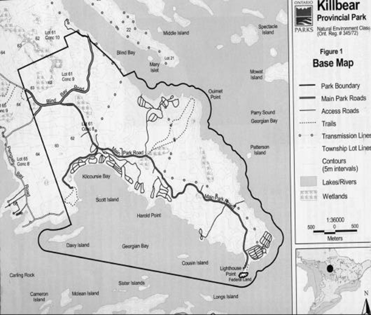
Killbear Provincial Park is a natural environment class park, located on the eastern shore of Georgian Bay. Killbear is situated in the geographic Township of Carling, in the District of Parry Sound. The park is located on a peninsula west of the Town of Parry Sound, and is comprised of 1133 hectares of land and 623 hectares of water (Figure 1).
Primary access to the Parry Sound area is by Highways 400 and 69, a section of the Trans-Canada Highway linking Hwy. 11 at Barrie to the south with Hwy. 17 at Sudbury to the north. Secondary Highway 559 provides the linkage between Hwy. 69 and the park. By road, it is 35 km from Killbear to the Town of Parry Sound. Alternative access to the park is by boat, along the main recreational boating channel linking Parry Sound to Georgian Bay and Lake Huron. By water, it is roughly 10 km from Killbear to the town dock in Parry Sound.
Killbear is located on the southern edge of the Canadian Shield, within the Great Lakes - St. Lawrence forest region, an area of transition between predominantly coniferous forest to the north and deciduous forests to the south. Along with Grundy Lake, a natural environment class park roughly 80 km to the north, Killbear provides good representation of the Parry Sound District (5E-7), in the Georgian Bay Site Region.
Upland maple-beech communities with scattered stands of white pine dominate the park’s vegetation. Black spruce and cedar occupy many of the poorly drained sites. Hemlock stands occur along the southern slope of the central ridge of the peninsula. Sedge and grass meadows, along with the variety of wetland types, are also present. The terrain consists of shallow to deep sandy till deposits, with large areas of exposed, gneissic bedrock, which display clear evidence of glaciation (e.g. striations, chattermarks) some 12,000 years ago. A number of the park’s earth and life science features are considered to be provincially significant.
A summary of background information on Killbear’s natural, cultural, and recreation resource base can be found in the Killbear Management Plan Review: Background Information, Issues and Options tabloid, released in June, 1998. A listing of individual inventory reports and other relevant information is included in the References section and the end of this document.
Figure 1: Base Map

2.0 Significant issues
Through previous consultation, park users, local residents, park staff, other individuals, and groups identified the following concerns related to Killbear’s management:
- Additions to the Park (refer to section 6.0)
- Hunting (refer to section 8.1.3)
- Level and type of development (refer to sections 9.0 and 10.0)
- Volume of use, and variety of users on the main park road (refer to sections 9.3.2 and 10.5)
- Variety of waterfront uses with respect to safety (potential collisions), health (fuel spillage and holding tanks), and aesthetics (groups of anchored boats 'monopolizing' areas, noise from personal watercraft) (refer to section 9.3.5)
3.0 Classification
As described in the Ontario Provincial Parks Planning and Management Policies (1992), Killbear Provincial Park is classified as a natural environment park. This class incorporates outstanding recreation landscapes with representative natural and cultural features to provide high quality recreational and educational experiences.
4.0 Goal
The goal of Killbear Provincial Park is:
To protect the park’s significant natural and cultural resources, and to provide opportunities for a wide variety of high quality recreational and educational experiences.
5.0 Objectives
Ontario’s provincial parks program has four objectives: protection, recreation, heritage appreciation and tourism. Each park in the system makes a contribution to these objectives, depending on its resource base. Killbear contributes to the achievement of all four objectives.
5.1 protection objective
To protect provincially significant environments which incorporate natural, cultural and recreational features.
The protection objective will be achieved through:
- the designation of appropriate zones (primarily nature reserve and historical) within the park
- the identification of management policies tailored to the sensitivity of the resources/values within each zone
- conducting relevant research
- monitoring the environmental effects of management activities and recreational use
Park management will take a 'greater park ecosystem' view, recognizing that management activities undertaken within the park may have environmental (natural, cultural, social, economic) effects outside the park boundary, and vice versa.
5.1.1 Life sciences
A number of life science (botanical, zoological, ecological) features within the park are provincially significant, and are the subject of protective nature reserve zones (see section 7.1). For example, the five hectare Kilcoursie Swamp contains a sedge meadow surrounded by a Black Ash mixed wood swamp, and provides critical winter habitat for several species including the Spotted Turtle, Blanding’s Turtle and Eastern Massasauga Rattlesnake. Future research and inventory work may yield information that results in the identification of new nature reserve zones or refinements to the boundaries of existing zones.
5.1.2 Earth science
Killbear contains a variety of provincially significant earth science (geological, geomorphological) features. The park’s bedrock is representative of the southern Britt domain, in the Central Gneiss Belt, which is part of the Grenville structural province of the Canadian Shield. The bedrock also exhibits evidence of the last glaciation in the form of striations and chattermarks caused by ice advance/retreat over the bedrock outcrops. The Nipissing Great Lakes shore dunes are considered as locally significant, but are generally better represented elsewhere in the parks system.
5.1.3 Cultural resources
The park contains three cultural (archaeological, historical) sites, which warrant protective historical zone designation (see section 7.2). Two sites, representative of early woods operations (logging, maple syrup) in the park are locally to regionally significant. The third, on Cousin Island, was an Aboriginal burial site and is the only known example of native culture within the park’s boundaries. It is a provincially significant site.
5.2 Recreation objective
To provide a range of outdoor recreation opportunities ranging from high-intensity day use to low-intensity back country travel.
The recreation objective will be achieved through:
- the designation of appropriate zoning (primarily access, development and natural environment)
- the identification of management policies aimed at providing a diversity of outdoor recreation opportunities without comprising significant natural/cultural heritage values
- conducting research into market trends, user preferences, travel behavior, etc.
- monitoring the environmental effects of recreational use and mitigating impacts through adaptive management
The park’s beaches, campgrounds, trails and offshore waters provide an attractive setting for a variety of recreational pursuits. They include day use activities such as swimming or picnicking; relatively vigorous, low-density trail use; and endeavors such as bird watching or nature photography. In an average operating season, the park offers a supply of roughly 375,000 camper nights and 72,000 day use opportunities.
5.3 Heritage appreciation objective
To provide visitors to Killbear with opportunities to explore and appreciate natural and cultural heritage of the park and the surrounding area.
The heritage appreciation objective will be achieved through:
- The provision of opportunities for unstructured exploration of the park and the surrounding area through:
- the provision of accurate, up-to-date information to park visitors regarding the park’s natural, cultural and recreational resources
- the availability of self-guided trails and interpretive displays throughout the park
- The provision of structured opportunities to explore and appreciate the park and surrounding area through:
- the provision of staffed Natural Heritage Education (NHE) program which incorporates all three program elements
- basic information, interpretation and outdoor recreation
- a Visitor Centre containing creative exhibits and information
A new non-profit, co-operating association called The Friends of Killbear Park was established in 2000. They will play a key role in supporting and enhancing natural heritage education and information products and services of the park.
During the 1993-99 operating seasons, a seasonal average of 11,900 people participated in Killbear’s NHE programs, 26,200 people used the park’s three interpretive trails and 31,500 interpretive publications were distributed.
5.4 Tourism objective
To provide Ontario residents and out-of-Province visitors with opportunities to discover and experience the park, Carling Township, nearby Parry Sound and the central Georgian Bay area.
The tourism objective will be achieved through:
- the provision of information to park visitors regarding the recreation facilities and services available in the park and the surrounding area
- the provision of a park Visitor Centre which will serve as an additional tourist attraction for the park and the area
- the involvement of park staff in selected tourism marketing/promotion activities and organizations
- ongoing efforts to define Killbear’s contributions to Ontario’s system of provincial parks
Killbear Provincial Park is an important part of the Central Georgian Bay tourist area and contributes to the local and provincial economies. Each year thousands of campers and day visitors spend money while visiting the park and the surrounding area. For example, in 1998, Killbear visitors spent an estimated $3.6 million dollars. In the same year, Ontario Parks spent approximately $1.2 million in park operations and capital development. The $4.8 million dollar expenditure adds an estimated $6.5 million (value added) to the provincial economy and supports 152 person years of employment (Ontario Parks, 2000)
6.0 Park Boundary
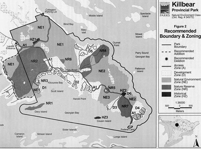
Three boundary amendments were considered during the preparation of this plan n (Figure 2). One involved the potential addition to the park of the Crown portions of Lots 64 and 65, Concession VIII, Carling Township which are immediately adjacent to the park’s western boundary. The second involved the potential deregulation of a small parcel in the northeast corner of Concession C, Carling Township.
This 0.57-hectare site is a parking lot, which has traditionally been used by Blind Bay cottagers. The third involved the possible deregulation of a small parcel containing the entrance to the Carling Township landfill in Lot 63, Concession IX. As identified in the preceding, the precise location of the park boundary has been a concern with regard to cottage access roads, the entrance to the Carling Township landfill and most significantly as it relates to the enforcement of no hunting in the park. The park boundary in Lots 61-63, Con. IX and in Concessions C, D and E, which was surveyed and cleared in 1997, will be inspected annually and flagged/cleared on an as-required basis.
6.1 Lots 64 & 65 Concession VIII
These two lots in Carling Township are predominantly Crown lands, with the exception of cottage development along the shorelines and several private parcels near the north end of the Pengally Bay Road. Both lots were identified for addition to the park in the 1977 master plan, based primarily on their recreation potential. Subsequent research and inventories have determined that these lots contain a variety of wetland ecosites and critical habitat for the provincially threatened Eastern Massasauga Rattlesnake, as well as several species of raptors.
This management plan re-confirms MNR's interest in amending the regulated boundary of Killbear Provincial Park to include the Crown portions of Lots 64 & 65, Con. VIII, Carling Township. This will be pursued in cooperation with the Sustainable Forest Licence holder of the two Crown lots, and in accordance with the Crown Forest Sustainability Act.
Figure 2: Recommended Boundary and Zoning Map
Enlarge Figure 2: Recommended Boundary and Zoning Map
6.2 Cottagers' parking lot (Carling Township)
The 0.57 hectare parking lot in the northeast corner of Concession C, Carling Township, situated on the west side of the Blind Bay road and opposite the boat launch, will be removed from the legal description of Killbear Provincial Park6.3 Landfill Entrance The main entrance road, as well as a limited parking and turnaround area on the east side of the Carling Township landfill, encroach on the regulated park boundary.
Ontario Parks will investigate the feasibility of deregulation the small parcel containing the landfill entrance, for the purpose of conveying it to Carling Township.
7.0 Zoning
Zoning is a key element in a Park Management Plan. Zones fulfill a variety of function s, which include:
- providing recognition of the features and attributes of a park
- delineating areas on the basis of their requirements for different types of management prescriptions
- providing a direct indication of the park’s contributions to the park program’s protection/representation targets for historical and nature reserve zones
As outlined in Ontario Provincial Parks Planning and Management Policies, natural environment class parks may contain any of six types of zones: access development, natural environment, wilderness, historical and nature reserve. Killbear contains five of the six zone types. It lacks undisturbed landscapes of sufficient size to warrant wilderness zone designation.
[Note: The zone boundaries and sizes identified on Figure 2 and in the accompanying text are approximate. Upon approval of this plan, zone boundaries will, wherever possible, be marked or reconciled with physical features on the ground, then mapped using a Geographic Positioning System (GPS) and overlain on the digital base map of the park.]
7.1 Nature reserve zones
Nature reserve zones protect important biological and geological features. A total of seven nature reserve zones have been designated in Killbear Provincial Park.
NR1: Davy Island (8.9 hectares) consists of a large bedrock outcrop with a thin veneer of sand on its crest. The sides are water-polished bedrock shelves and steep, fractured cliffs. Plant communities are early to mid-succession upland White Pine forest. The island also provides habitat for a variety of breeding and migratory birds.
NR2: This 198.7-hectare zone includes well-drained upland Sugar Maple forest and upland mixed-wood (Sugar Maple, American Beech, Yellow Birch, Red Maple, Basswood, and Eastern Hemlock) forest with pockets of Eastern Hemlock, White Cedar and Balsam Fir on moister sites. A portion of this zone, illustrated on Figure 2, includes the recommended additions identified in section 6.1. The zoning and associated policies for the new addition will only take effect a after the area is formally added to the park through a regulation change. The western portion, bounded by the Pengally Bay Road, contains some Black Ash/ Yellow Birch swamp, alder thickets and sedge meadows which include representation of a variety of southern flora and provide "critical" habitat for the Eastern Massasauga Rattlesnake as well as several species of raptors.
Also included in this zone is the meadow adjacent to the overflow park lot, just west of the main Control Office. It has high interpretive value, providing examples of 'sand pit succession' and peatland formation. It contains a community of Ladies' Tresses Orchids and a variety of mature lichens displaying especially large growth forms.
NR3: Kilcoursie Swamp is roughly 5 hectares in size, and contains a sedge meadow surrounded by a Black Ash mixed wood swamp. It contains critical winter habitat for several rare species including Spotted Turtle, Blanding’s Turtle and Eastern Massasauga Rattlesnake.
NR4: The Lookout Trail Nature Reserve (66 hectares) includes a wide variety of forested ecosystems, representative of Killbear Provincial Park. The area consists of a cattail marsh, alder shrub thicket swamp, Black Ash swamp, cedar/hemlock lowland swamp, upland hemlock forests, tolerant hardwood forests, upland White Pine/Red Oak/juniper bedrock associations, rocky cliff communities and rocky shoreline communities. A variety of uncommon and rare orchids and representative southern floral species occupy the forests.
NR5: The Harold’s Point "Peatland" (4.1 hectares) is actually a fen with a floating Leatherleaf/sphagnum mat, which supports a variety of rare flora. While the site has good interpretive potential, it is very susceptible to onsite damage from pedestrian traffic.
NR6: The Ladies' Tresses Orchid site (2.1 hectares) has developed in an abandoned sandpit used in the early 1960s when the park was opened. This reserve was originally established to protect a unique hybrid orchid. No evidence of the hybrid was found during recent field investigations. Several other orchid types, along with two uncommon sedges, are present in this area characterized by a high diversity of plant species in a small geographic location.
NR7: This site (37.8 hectares) consists of a narrow sand beach with Green Ash/Speckled Alder shoreline; and a backshore forest of Red Maple, White Birch, Trembling Aspen and Red Oak. It is one of the only relatively undisturbed natural beaches Massasauga Rattlesnake.
7.1.1 Zone management
New development will be limited to trails, necessary signs, and temporary faculties for research and management; all decisions regarding the type, extent and location of facilities must be supported by detailed resource inventories; all development will be carried out in accordance with approved site and development plans.
Non-native plant species will not be introduced; where they are already established and threaten other natural heritage values, a program for their eradication will be developed. Missing plant species may be re-established if biologically feasible and acceptable.
Given the degree of capital development within the park, and its proximity to private development, all fires occurring in nature reserve zones will be suppressed. Management will normally be directed towards the maintenance of an evolving natural succession, unless the rationale for an alternative approach can be documented.
Motorized/mechanized travel in nature reserve zones will not be permitted, except on trails designated for such purposes by the Park Superintendent (e.g. wheelchair accessible interpretive trails).
7.2 Historical zones
Historical zones are intended to protect important historical and archaeological resources. They generally focus on a specific site, such as an occupation site or a building, and its relationship with the surrounding landscape.
Killbear contains three small historical zones.
HZ1: The Thompson cabins, originally located in this area, were built and used between 1915 and 1945 for logging and maple syrup operations. While no buildings and artifacts are evident, this area (3.1 hectares) is still used for interpretive programs.
HZ2: This 1.6 hectares site, near the entrance to the group camping area, is the site of a former logging camp.
HZ3: Cousin Island (2.1 hectares) is believed to have been used at one time as a native burial site. This is the only known example of native history within the park’s boundaries.
7.2.1 Zone management policies
New development will be limited to: trails and necessary signs; interpretive, educational, research and management facilities; means of travel appropriate to the historical resource; and historical restorations and reconstruction, where appropriate.
All decisions regarding the type, extent and location of facilities must be supported by detailed resource inventories; all development will be carried out in accordance with approved site and development plans.
Depending on the feasibility of developing a maple syrup operation (see section 8.2), consideration may be given to enlarging zone HZ1 to incorporate more maple bush.
Ontario Parks may carry on agricultural operations, which depict activities associated with the history of Ontario.
Non-native plant species will not be introduced; where they are already established and threaten other natural heritage values, a program for their eradication will be developed. Missing plant species may be re-established if biologically feasible and acceptable.
Given the degree of capital development within the park, and its proximity to private development, all fires occurring in historical zones will be suppressed.
Motorized/mechanized travel in historical zones will not be permitted, except on trails designated for such purposes by the Park Superintendent (e.g. wheelchair accessible interpretive trails.
7.3 Access zones
Access zones facilitate visitor travel into the park.
A1: This 26-hectare access zone consists of a 40 metre wide corridor centered on the main park access road, stretching from the terminus of Hwy. 559 at the park boundary to the parking lot at the Lighthouse Point day use area.
7.3.1 Zone management policies
Development will be limited to primary park roads, pathways, gatehouses, short-term parking and traffic control structures, signs and other information aids.
Vegetation management may be undertaken, primarily for safety purposes. The removal of trees or other vegetation encroaching on travel corridors is permitted in order to eliminate hazards, improve sight lines, etc.
7.4 Development zone
Development zones contain most of the park’s facilities, and are designed to accommodate large numbers of day use visitors and care camping activities.
Killbear contains a total of six development zones.
D1: This small 7.9-hectare zone contains the Twin Points day-use area, including the beach, parking lot and picnic area.
D2: This 164 hectare zone includes: the main park Office and overflow (waiting area) parking lot; the maintenance and service yard and facilities; the sludge lagoon, the NHE office; staff quarters; the Kilcoursie, Beaver Dams, Georgian and Harold’s Point campgrounds, and
the longest and best beach in the park. The zone also includes the location for a new Visitor centre.
D3: The Granite Saddle Campground plus potential campground expansion (23.1) hectares).
D4: The Lighthouse Point Campground, plus potential campground expansion area (43.6 hectares).
D5: The Blind Bay Campground and access road
(55.1 hectares).
D6: The group camping area (4.2 hectares).
7.4.1 Zone management policies
New development may include signs, secondary/tertiary roads, park administration and maintenance facilities, visitor centre, utilities, staff facilities, beaches, picnic areas, campgrounds, alternative roofed accommodation, displays and facilities for education, research and management.
All decisions regarding the type, extent and location of new facilities must be supported by detailed resource inventories; all development will be carried out in accordance with approved site and development plans.
Recreation and tourist services (and support facilities), operated by public, private or not-for-profit providers, must be consistent with the provisions of the management plan and the Killbear Provincial Park Business Plan.
7.5 Natural environment zone
Natural environment zones include important natural landscapes. Minimal development is required to support low-density backcountry uses such as canoeing and hiking. Natural environment zones often serve as 'buffers' between development or access zones and the more protection-oriented wilderness, historical and nature reserve zones.
Killbear contains a total of three natural environment zones.
NE1: This zone, approximately 402 hectares in the northern portion of the park, contains a variety of wildlife habitats. A portion of this zone, illustrated on Figure 2, includes the recommended additions identified in section 6.1. The zoning and associated policies for the new addition will only take effect after the area is formally added to the park through a regulation change.
NE2: This 161 hectare zone is located in the southeast portion of the park. It contains large areas of bedrock barrens, with soils ranging from very thin to absent. Vegetative cover is highly variable, depending on soil depth, drainage, and sit exposure.
NE3: This 38.8 hectare site between the Harold’s Point and Granite Saddle campgrounds contain some upland maple-beech hardwood forest and scattered stands of hemlock.
7.5.1 Zone management policies
New development will generally be limited to trails, signs and other information aids.
All decisions regarding the type, extent and location of new facilities must be supported by detailed resource inventories; all development will be carried out in accordance with Ontario Park’s policies, including approved site and development plans.
8.0 Resource stewardship policies
The management policies presented in this plan must ensure that recreational use does not compromise the quality of Killbear’s natural and cultural resources. Their health must be sustained over the twenty-year term of the plan, and beyond, in order for the park to remain viable.
The management of Killbear’s natural and cultural resources will conform with the policies identified for natural environment class parks in Ontario Provincial Parks Planning and Management Policies (1992). Supplementary policy direction is provided in the following.
8.1 Natural resources
8.1.1 Aquatic
With the exception of several small creeks, there are no inland waters in the park. The original construction of the main park road and the Blind Bay road altered the natural drainage of some of the wetlands on the peninsula. Over time, these ecosystems have adapted to the changes in drainage; restoration of natural drainage could result in environmental damage.
All site and development plans associated with capital development will include mitigation measures to protect existing drainage.
8.1.2 Fisheries
There are no inland waterbodies supporting sport fishing in the park. The offshore waters of Georgian Bay provide excellent recreational fishing opportunities for species such as Pickerel, Northern Pike, bass and Lake Trout. Restrictions are currently in place to protect natural populations of Lake Trout. Such restrictions may be amended from time to time to ensure protection of the trout fishery.
Fishing activity in park waters will be subject to provincial fishing regulations.
Commercial Fishing and commercial bait fishing are prohibited in park waters.
8.1.3 Wildlife
Deer management
Beginning in the early 1960's, research was undertaken on the effects of manipulating natural winter food supplies for White-tailed Deer. A series of 400 m2 plots were cleared in the area around the Lookout Trail. These browse plots were clear cut to allow new growth to generate in order to provide winter food for the deer. Requirements for treatment of the plots, and their use by deer is dependent on a number of factors.
Including severity of winter, head size and availability of other food sources.
In another initiative, a number of winter-feeding stations, accessible via snowmobile, have been operated in severe winters to supplement naturally available food sources. While the majority of this activity has occurred in the north end of the park, feed has been distributed at a number of sites along an internal trail network, which runs along the peninsula.
Both of these programs operated intermittently during the '90's, depending on need (i.e. severity of winter conditions), availability of funding and availability of manpower.
In the interest of continuity, Killbear Provincial Park will, where feasible, continue to cooperate in ongoing research into browse management. If a consistent program of management, monitoring, evaluation and reporting cannot be maintained, or becomes redundant, this research will be discontinued.
Park and District Staff will explore the opportunities for delivery of outdoor education programs related to White-tailed Deer.
In pursuit of more natural habitat conditions, winter feed supplementation within the park will be phased out in favour of sites on private/Crown lands outside the park.
Reptiles
Killbear Provincial Park contains habitat for several significant reptiles. Most notable among them are:
- the Eastern Massasauga Rattlesnake and the Eastern Fox Snake, both currently listed as Threatened in Canada
- the Eastern Hognose Snake and the Five-lined Skink, both listed as Vulnerable/Special Concern in Canada
The status of such species are reviewed from time to time by the Committee on the Status of Endangered Wildlife in Canada (COSEWIC) and the Committee on the Status of Species at Risk in Ontario (COSSARO). In accordance with Ontario Parks policy, species designated by these committees will be afforded the same level of protection as species declared in regulation under Ontario’s Endangered Species Act.
Operations and development activities undertaken within the park will be carefully considered to ensure that they do not jeopardize species at risk or their habitat.
Wherever possible, park staff will develop or participate in user education and information programs regarding these and other significant wildlife species. Ontario Parks recognizes that the seasonal movements of many species of wildlife result in their movement between Killbear Provincial Park and surrounding areas. To fulfill park objectives, park staff will contribute to initiatives that foster wildlife stewardship in the greater park ecosystem.
A resource stewardship plan for the park’s species at risk reptiles will be prepared.
The plan will be composed of two parts: a framework conservation strategy, and; specific guidelines for individual species (the guidelines will be developed over time as specific research and information becomes available to support detailed guidelines for species). The stewardship plan will include:
- guidelines for the protection of species and their habitat
- Directions for further research and monitoring of Killbear’s species at risk populations; and natural heritage education initiatives within the park and the community to promote protection of species at risk
Active management for species at risk will be carried out in accordance with available species recovery plans or in consultation with recognized experts.
Ontario Parks will promote the use of the knowledge and management strategies developed through applied research in Killbear Provincial park, to assist reptile conservation initiatives in other jurisdictions.
Nuisance animals
From time to time, animals may pose a threat to the public health or safety, or to park facilities (e.g. flooding or washouts of park roads). Wildlife management may be undertaken on an 'as required' basis in order to protect the health and safety of park visitors, or to protect park facilities.
The removal of nuisance animals will be undertaken by, or under the supervision of Ontario Parks Staff.
Hunting
Hunting is prohibited within the boundaries of Killbear Provincial Park.
No regulation under the Fish and Wildlife Conservation Act exists to authorize hunting. Some deer hunting has occurred in the past on parklands adjacent to the Blind Bay Road. This was due, in part, to the fact that the park boundary was not clearly delineated on the ground. Steps to resolve the situation began in 1997 when the boundary was surveyed and flagged to facilitate administration and enforcement. This management plan confirms that the area will be posted as 'No Hunting' and enforced accordingly.
8.1.4 Vegetation
Commercial timber harvesting is prohibited within the park.
Vegetation management in the park’s nature reserve and natural environment zones will normally be directed towards protecting natural features and conditions in an undisturbed state, allowing for natural succession. Exceptions may include:
- the treatment of browse plots for White-tailed Deer (see above) for research purposes
- removal of safety hazards in areas frequented by park visitors
- management of the forest used to support the sugar bush operation
Infestations of forest insects and diseases will be monitored and assessed on an ongoing basis. Where outbreaks threaten park values, they may be controlled. When control is undertaken, it will be directed as narrowly as possible to the specific insect or disease so as to have minimal effects on the balance of the park environment. Biological controls will be used whenever possible.
Both the trees and the understory in the park’s access and development zones may be subject to management, including: removal of hazard trees; underplanting with native species to improve diversity and/or aesthetics; hand tending of trees and shrubs to reduce competition; and brushing/clearing along primary and secondary roads to improve sight lines or traffic flow.
Sustained, heavy recreational pressure particularly in the campgrounds adjacent to Kilcoursie Bay has resulted in the depletion of the forest understory. This has a negative impact in terms of campground aesthetics and loss of privacy.
A program of under-planting using native trees and shrubs will be undertaken, in campground/day-use areas that exhibit significant wear and tear.
Ontario Parks will investigate the feasibility of establishing an in-park nursery area to be used to cultivate native trees, shrubs and plants for use in rehabilitation work.
Killbear Provincial Park will develop a program to educate park users regarding the responsible use of the park’s natural resources in an effort to minimize 'campsite sprawl', creation of unofficial pathways, damage to park vegetation, etc.
A resource stewardship plan for vegetation will be prepared for Killbear Provincial Park. It will provide specific prescriptions to address vegetation management needs in all of the park’s zones; as well as outlining how the impacts of vegetation management activities will be monitored and evaluated.
8.1.5 Landforms
There is historical evidence within the park, and on Lots 64 and 65, Con. VIII, of a number of small pits used as sources for sand and pit run material. As noted in the earth science inventory, some of these deposits can be related to Nipissing Great Lakes dune systems, the remnants of which now appear as a series of subtle mounds in the forest.
Aggregate extraction from sources within the park is prohibited; aggregate required for capital development projects will be acquired from commercial sources outside the park.
The defacing of bedrock outcrops (carving and painting), particularly in the vicinity of campground and day-use areas, is a significant problem, and has resulted in degradation of the park’s earth science resources.
A program combining public education and, where feasible, greater enforcement will be developed and implemented in an effort to encourage greater public stewardship of Killbear’s natural resources.
8.1.6 Fire
As noted in the Introduction, mixed hardwoods, with Red Oak and Eastern White Pine on drier upland sites dominate Killbear’s forests. With the exception of accumulations of poorly drained organic material in bedrock depressions, soils tend to be shallow, and drain quickly. Prolonged dry conditions can significantly increase the risk of fire.
Given the capital investment in facilities within the park, and the degree of structural development adjacent to the park, natural and human-caused fires in all zones will be suppressed.
Fire suppression techniques which have the last residual impact on the park’s natural environment will be utilized whenever possible.
Depending on the fire hazard, restrictions on open fires may be implemented by the Park Superintendent in consultation with the local MNR Fire Office and Township Fire Chief.
8.2 Cultural resources
The focus of cultural heritage representation in Ontario Parks is the protection of significant, landscape-related cultural resources. As noted in the Background Information, Issues and Options (June/98) tabloid, there are no archaeological or historical features still in evidence in the park.
Interpretation related to the spiritual significance of Cousin Island will be delivered through off-site means. Local Aboriginal peoples will be consulted to determine appropriate interpretive messages and the means to convey them.
Park staff will investigate the feasibility of developing/operating a historically authentic maple syrup operation in HZ1 the Thompson cabin site, adjacent to the Blind Bay Road.
9.0 Operations policies
Operations policies deal with topics such as Natural Heritage Education, recreation management, and the provision of recreation and tourist services, business planning and research.
A Park Operating Plan currently provides park staff with the necessary information to operate the park on a day-to-day basis. In addition to addressing the operations policies that follow, the plan includes topics such as budget, staffing, and maintenance schedules, enforcement and emergency services. The operating Plan is consistent with approved Ontario Provincial Parks Minimum Operating Standards (1992).
Killbear’s Operating Plan will be reviews annually, and updated as required.
9.1 Natural heritage education
As outlined in the Strategic Plan for Natural Heritage Education in Ontario Parks (1997), the goal of the Natural Heritage Education (NHE) program is to develop visitors' awareness and appreciation of Ontario’s natural and cultural heritage, fostering a commitment to its protection for all generations. Opportunities to do so will be educational and recreational, formal and informal, and accessible to all people.
The objectives of the NHE program are to provide basic information in all parks, interpretation of Ontario’s natural and cultural heritage, and outdoor recreation in representative landscapes in Ontario. Given its combination of provincially significant natural resources and high level of visitation, Killbear will provide a major activity level of service, with the support of The Friends of Killbear Park (refer to section 5.3).
As described in the revised NHE programming guidelines (1993-1994), natural environment class parks such as Killbear will provide:
- A comprehensive, high quality information system
- A full range of interpretive programs (staff led, publications, facilities)
- Outdoor recreation skills program
As prescribed in approved policy (circular PM 6.02), a Natural Heritage Education Management Plan has been prepared for Killbear. Direction was taken from provincial policy, the regional/zone NHE plan, and the Park Management Plan. Killbear’s NHE Plan will be reviewed annually, and updated as required.
Interpretation will focus on the exiting themes, specifically:
Earth/Life Science Themes
- Georgian Bay shoreline
- Eastern Massasauga Rattlesnake
- Transitional Ecology (i.e. north meets south)
Historical Themes
- Georgian Bay Lumber
- South Shield Agriculture homesteads
- Upper Great Lakes Internal Shipping
- Early Recreation Amongst the Thirty Thousand Islands
The scope and intent of all NHE activities will be carefully defined to ensure their compatibility with park features.
The NHE plan will address any changes of existing themes, or the establishment of new themes, that may develop as a result of research activities.
9.2 Research and information
Ontario Parks research and information needs relate directly to the Ministry of Natural Resources' mandate and the provincial park system’s distinctive goal and objectives. Park-based research needs to address the wide range of environmental, social and economic factors necessary to administer an ecologically sustainable system of parks. It is also important that research activities address the demand for quality outdoor recreation experiences and customer satisfaction. Research and information needs are diverse. They cover the full spectrum of geological, biological, cultural and social sciences.
Scientific research and monitoring by qualified groups and individuals will be encouraged. Researchers must comply with the Ontario Parks Research and Information Strategy, Ontario Parks, Central Zone Research and Information Strategy, and Ontario Parks policy on research activities in provincial parks (PM 2.45) and will require prior written permission.
Research priorities in Killbear Provincial Park will include:
- Eastern Massasauga Rattlesnake, Eastern Fox Snake and other Species and Risk-habitat, distribution, behavior and management requirements
- Coastal processes and human impacts on beach dune systems
- Small mammal populations as biodiversity indices
- Preparation of detailed earth science inventory
- Additional life science studies to supplement existing inventory
- Identification of cultural heritage values and management options for Cousin Island
9.3 Recreation management
As outlined in the Background Information, Issues and Options (June/1998) report Killbear is one of the most popular parks in the provincial system, with total visitation averaging 250,000/year. It is clearly a 'destination park' with the highest average length of stay (7.2 nights) in the provincial parks system.
That same background report noted that just under half of the park has little to no soil development, consisting of bedrock exposures and pockets of poorly drained organic material in bedrock depressions. Most of the recreational activity in the park takes place on the remaining land base, and can exert considerable stress on the ecosystems involved.
9.3.1
From a high 1036 in the early 1970's, the total number of campsites at Killbear has gradually been rationalized to the 1998 level of 880 sites. During the peak-operating season in July and August, Killbear’s average occupancy is around 88%, with full occupancy on most weekends. Campground development will continue to be rationalized; marginal sites (based on size, slope, soils, density) will gradually be phased out; that capacity may be replaced elsewhere in that campground, or in the park.
Demand for additional campground capacity will be monitored on an ongoing basis.
Development of new/replacement sites will comply with Ontario Parks' standards and guidelines governing capital development.
9.3.2 Trails
With a campground population of roughly 3200 people on an average summer day, there is considerable demand for trail-based recreation. Killbear’s three hiking trails, ranging in length from 0.8 to 3.5 km, are not adequate to meet the needs of park visitors. New trails would provide variety as well as reducing site impacts by dispersing use.
Camper comments and the results of the 1996 Provincial Park Camper Survey indicated a demand for new trail opportunities for walkers, hikers and cyclists.
Ontario Parks staff has begun to assess the undeveloped portion s of the park for hiking and mountain biking trail potential; overall feasibility and final alignments would be subject to detailed inventories and site planning. The cumulative effects of development in terms of landscape fragmentation will be a primary concern in assessing feasibility.
In order to provide opportunities for less physically demanding walking or cycling trails, and to separate motor vehicles, pedestrians and cyclists, Ontario Parks is proposing the development of a bike/hike path beside the main park road, which will eventually connect the main park Office with the Lighthouse Point area.
At the time of preparing of this management plan, Killbear was being looked at as a potential node, linked to Algonquin Park by a multi-use, four season trail. This park-to park trail is part of a larger 'Adventure Tourism Destination' project potentially involving partners from the public, private and not-for-profit sectors.
9.3.3 Recreation and tourist services
Recreation and tourist services, and support facilities generally include: accommodation; food and beverage services; rental or sale provision of recreational services (e.g. transportation, packaged tours, natural heritage education services); and the provision of traditional recreational facilities (e.g. car camping, day-use and natural heritage education). To date, the park has offered these kinds of traditional services and facilities. Private Sector suppliers near the park have provided food and beverage services and the sale of camping supplies.
Killbear receives heavy recreational use during the peak-operating season of July and August, low during the spring and fall shoulder seasons, and low use during the winter. Improvements to recreational and tourist services could improve the quality of the park experience for traditional park users, as well as potentially attracting new campers and day visitors during the less used shoulder seasons. Examples of such facilities/services include bike paths, interpretive trails, more electrical sites, recreational equipment rentals, and a retail Outlet for The Friends of Killbear Park, a new visitor centre, and alternative accommodation. The Ontario Consumer Survey for Ontario Parks (COMPAS Inc. 1998) showed that the provision of cabins/shelters would motivate visitors to use parks more in the fall, winter and spring.
Public input during the planning process regarding the provision of recreation and tourist services was mixed. For example, some respondents:
- head philosophical and/or operational objections to providing alternative roofed accommodation (e.g. yurts, rental cabins) in the park, while others supported the idea, especially for the park’s shoulder (spring and fall) seasons
- felt that the current level of development is at, or beyond, optimum levels from the visitor’s perspective
- were generally not supportive of commercial developments such as stores or snack bars, or felt that the provision of food and beverages, and the sale of camping supplies (groceries and equipment) were best left to the various private sector operators on the park’s periphery
- supported certain types of recreation and tourist services such as accommodations, the rental of recreational equipment and the provision of transportation and prepackaged tours
This input suggests that a cautious approach should be taken when considering new recreational facilities and services in the park.
In the future, Ontario Parks may be approached with unsolicited proposals, or may issue requests for proposals related to upgrading or establishing new tourist services/facilities. Provision of those services may involve the public, private or not-for-profit sectors, exclusively or in some form of partnership.
Ontario Parks will be cognizant of public and park visitor concern about potential over-use and over-development, and will follow a cautious approach when considering the provision of new recreation and tourist services.
Ontario parks will be sensitive to the interests of neighboring private sector businesses, and will consult with local interests when new ventures are being considered for the park.
Ontario Parks will examine options to better utilize existing capacity such as:
- incremental improvements to existing facilities, marginal sites
- marketing of shoulder season opportunities
- changed in administrative procedures
Ontario Parks will conduct feasibility assessments (and if appropriate, implementation plans) regarding options for the provision of recreation and tourist services in Killbear Provincial Park, including:
- the rental of recreational equipment such as bicycles, canoes, and windsurfers
- boat tours
- the establishment of alternative accommodations to encourage off-season use. This could include:
- use of existing staff house as a lodge/meeting facility outside the park operating season
- installation of seasonal, roofed structures (e.g. yurts, 'habitats', tent platforms) on selected, existing campsites. These may be tested on a limited basis as part of a feasibility assessment
All proposals for recreation/tourist services (and support facilities) will be evaluated on the basis of approved Ontario Parks guidelines.
All proposals must conform to the provisions of the approved Park Management Plan and the Killbear Provincial Park Business Plan.
Opportunities to provide services will normally be awarded via a competitive tendering process, although pilot projects may be considered.
9.3.4 Winter use
Traditionally, Killbear has not operated in the winter. However, in recent years there has been an increase in the number of people visiting the park to hike, snowshoe and cross-country ski.
Ontario Parks will solicit expressions of interest in running a winter operation at Killbear, focusing on the provision of cross-country ski and snowshoe trails; emphasis will be on the use of the park’s existing road network to minimize impacts on winter deer populations.
Details of any winter operation will be addressed in the park’s Operating Plan and Business Plan.
9.3.5 Adjacent lands/waters
There are currently three 'roads' which provide access to a series of private cottage lots. The access roads connect with the Blind Bay Road, in Concessions D and E, Carling Township, in the north end of the park. To date, and in their current state, these roads have not been a management concern. However, the potential exists that future, unauthorized improvements to these roads could jeopardize wildlife habitat, alter drainage patterns or facilitate access to areas of the park which are currently undisturbed.
The Park Superintendent will formalize the authority for the three cottage access roads through the issuance of a letter of authority.
The precise location of the roads will be mapped using GPS technology, and incorporated into digital base mapping for the park .
Maintenance or upgrading of the sections of cottage access road within Killbear Provincial Park will require the approval of the Park Superintendent.
As noted in the Background Information, Issues and Options, the park’s land base does not include the 1.4-hectare site of automated lighthouse on Lighthouse Point, which belongs to the federal crown.
The maintenance and operation of the lighthouse will continue to be the responsibility of the Canadian Coast Guard (Marine Aids Program), Department of Fisheries and Oceans.
Due to Killbear’s proximity to Georgian Bay, the park’s waters are a popular anchorage for recreation boaters. There is currently no charge for overnight anchoring. Perceived safety issues related to use of near shore waters and beaches by swimmers, unpowered small craft, larger cruisers and personal watercraft is clearly an emerging issue in this plan. A number of respondents also commented on the less tangible issues of recreation aesthetics and potential water pollution from fuel or holding tanks.
The policies presented below differentiate between the activities of mooring (tying to park property - e.g. vegetation, pins, buoys and anchoring to secure watercraft.
Beaching or moorings of small craft within buoy lines designating swimming areas will not be permitted. Mooring to shoreline vegetation will be discourages in order to minimize damage and incremental loss of vegetation.
Boats anchored within park boundaries will be requested to stay a minimum of 30 metres offshore.
Boaters who come back ashore to use park facilities (e.g. beaches, picnic areas, and comfort stations) will be required to pay the day use fee.
Ontario Parks will monitor relevant legislation and policy which has implications for recreation management along the park’s shoreline and in near shore waters.
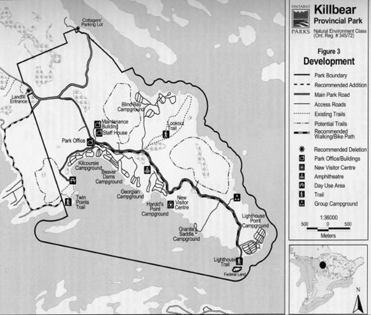
10.0 Development policies
The purpose of this section is to present concise development concept for Killbear Provincial Park, and to identify priorities for new development and redevelopment of existing facilities. The development plan is depicted in Figure 3.
10.1 Traffic Control and Distribution Particularly during peak visitation periods, Killbear processes large numbers of park visitors in a relatively short period of time.
The current system, which relies on a central control office and a series of sub-offices at key distribution points has advantages and disadvantages in terms of customer service, deployment of staff, communications, public safety, etc.
Ontario Parks will assess the feasibility of switching from a primary control office with sub-offices to one, a multi-lane front gate to process visitors to the park.
Figure 3: Development Plan Map
Enlarge Figure 3: Development Plan Map
10.2 internal roads and parking
The attractiveness of the beaches on Kilcoursie
Bay draws campers from elsewhere in the park. For those who use their automobiles, there is inadequate parking in the vicinity of the beaches at Harold Point, Kilcoursie and Beaver Dam. This results in congestion on some internal roads, causing traffic hazards and inadequate access for emergency vehicles.
Options for additional vehicle parking in the vicinity of the park’s main beaches will be investigated. Other measures may include posting areas to 'No Parking', provision of a shuttle service, and/or increased enforcement.
The feasibility of using the current overflow parking lot, west of the main control office, as an additional vehicle parking lot will be investigated.
10.3 Comfort stations
At [resent, five of the park’s comfort stations are in need of shower additions; and at least one of those five may be a candidate for complete replacement.
In order of priority, shower additions will be added to the comfort stations in Lighthouse Point, followed by Georgian and the two stations in Blind Bat.
The comfort station in Georgian Campground will be assessed to determine whether replacement would be more cost effective then upgrading.
10.4 Day use areas
The existence of numerous other beaches in and around the Parry Sound area means that the park’s potential to generate significant increased use by local residents is limited. There may, however be some potential to encourage more use by clientele from nearby lodges and resorts. Increased use of the day use area for special events and by anchoring boaters, may also be a possibility.
The feasibility of developing a picnic shelter, showers and increased washroom capacity at the Kilcoursie Day Use Area will be investigated.
Any proposals for capital development will be supported by a business case.
10.5 Trails
The current system of three short trails (Twin Points, Lighthouse Point and Lookout) offers a limited supply, and diversity, of walking/hiking opportunities for park visitors. Camper comments, responses to the Park User Survey, and initial public response to the Background Information, Issues and Options all indicated support for additional walking/hiking trails.
The feasibility of extending the Twin Points Trail into Lots 64 and 65, Concession VIII will be assessed on the basis of earth and life science inventories, site planning, and pending their addition to the Park.
The park’s interior, specifically zones NE1 and NE2, will be assessed for their trail potential including hiking or mountain biking in the summer, and cross-country skiing or snowshoeing in the winter. Potential impacts on the habitat of the Eastern Massasauga Rattlesnake, and on winter deer populations, as well as landscape fragmentation will be primary concerns.
Development of a walking/biking path adjacent to the main park road, linking the Park Office to Lighthouse Point, is desirable from a variety of perspectives. It would provide alternate walking and cycling opportunities for park visitors. It would separate cyclists and pedestrians from vehicular traffic using the main park road, where the traveled surface and shoulders are narrow and sight lines are restricted on some curves.
The feasibility of developing a pathway suitable for cyclists, pedestrians and wheelchairs, paralleling the main park road, will be assessed on the basis of resource inventories and site planning. If study results are positive, a project plan will be prepared to address site planning, engineering and construction considerations.
10.6 Utilities
10.6.1 Water systems
Water systems will be strictly maintained in accordance with provincial regulations. New systems will be installed as required.
10.6.2 Sewage systems
There are several sanitation systems operating in Killbear, including septic tile fields and numerous vault privies. The park also contains an approved sludge lagoon where effluent pumped from vault privies in the park is dumped.
Sanitary facilities will continue to be maintained, upgraded or replaced on an as - required basis, in accordance with Ontario Parks policies and guidelines, and approvals issued by the Ministry of Environment.
10.6.3 Electrical systems
Killbear’s electrical supply includes both overhead and buried electrical cable. The overhead system is visible in a variety of locations throughout the park. Ontario Parks owns the line, which would not meet contemporary standards set by Ontario Hydro.
A detailed assessment of options for the replacement and upgrading of Killbear’s overhead electrical supply system will be undertaken within five years of the approval of this plan.
10.7 Interpretive facilities
The current Visitor Centre is inadequate for a park with a major activity Natural Heritage Education program. A new facility, which provides space for programming, exhibits, storage of audio-visual and resource materials, NHE staff offices and lab facilities will be built on a location east of the Harold Point campground.
A feasibility study has been undertaken to determine this as the preferred location for a new Visitor Centre at Killbear. Subsequent development will be supported by detailed inventories; all development will be carried out in accordance with approved site and development plans.
10.8 Park maintenance and operations facilities
Killbear Provincial Park’s maintenance and operations facilities are generally adequate. However, particularly during the peak-operating season, the maintenance building often lacks the necessary capacity to accommodate the various projects underway in the park. Current dry storage facilities, which rely on several cabins salvaged from the former Junior Ranger camp, are inadequate as these cabins are at, or beyond, the end of their serviceable life.
A capital project for the expansion of the existing maintenance build will be prepared.
11.0 Implementation priorities
Prioritized lists of implementation priorities identified in this management plan are presented below.
11.1 Resource stewardship
- preparation of a Vegetation Management Plan
- preparation of a Resource Stewardship Plan for the park’s species at risk reptiles
- development of public education program on shared stewardship of natural and cultural resources, and costs (e.g. rock outcrop defacing)
- further research into the significance of Cousin Island burial site
- conduct feasibility study on in-park nursery for native plants
11.2 Development
- construction of new Visitor Centre:
- site/design concepts
- site-specific inventories and development concepts:
- interior mountain bike, hiking and winter use trail system
- bike/hike pathway adjacent to main park road
- extension of Twin Points Trail
- site analysis and development concepts for additional camper parking near main beaches
- development plans for shower additions (Lighthouse Point, Georgian, Blind Bay) and assessment of Georgian comfort station
- multi-lane gate feasibility
- redevelopment/upgrade concept and business case for Kilcoursie Day Use Area (picnic shelter; wash rooms/showers)
- long-term monitoring of park visitation, use patterns and demand analysis (e.g. expansion of electrical service, provision of walk-in campsites)
11.3 Operations/administration
- pursue the additions of Lots 64-65, Con 8, Caning Township in cooperation with the Sustainable Forestry License holder
- preparation of boundary regulation amendments to:
- delete part lot 63, Con. IX - Carling landfill entrance
- delete part lot Con. C (0.57 hectares) for Blind Bay Cottagers parking lot
- formalize agreement for cottage access roads, Con. D&E, Carling Twp
- conduct feasibility assessments (and implementation plans, if appropriate) regarding recreation and tourist service options including:
- recreational equipment rentals such as bicycles, canoes and windsurfers
- boat tours
- establishment of alternative accommodations to encourage off-season use such as the service of the existing staff house as a lodge, and seasonal roofed structures (yurts, 'habitats' tent platforms)
- solicit expressions of interest for operation of:
- winter season facilities (permit sales, trail grooming, etc.)
- recreational equipment rental concession
- sugar bush/maple syrup operation
- development and/or operation of alternative accommodation (see section 3.3)
- assessment of future options for park water system
- assessment of future options regarding hydro distribution system
- annual review/update of park Operating Plan
- annual review/update of park Natural Heritage Education Plan
11.4 Project screening
The conditions of Ontario Parks' present coverage under the Environmental Assessment Act, require that all park management activities conform to approved legislation, policy, procedures, guidelines and standards, including provisions for public notice. Their inclusion for consideration in this Park Management Plan constitutes the principal public review opportunity. Exceptions to this are projects where further study is required, or a decision has been deferred to a subsidiary plan.
Projects or activities, which will require the preparation of separate project plans, including opportunities for public review prior to implementation, are:
- implementation plan for the new Visitor Centre (consideration of potential effects, architecture, interior design, etc.)
- resource stewardship plans (e.g., vegetation, reptiles)
- development plans for interior mountain bike or hiking trails (inventory results, consideration of alternative routes, and assessment of impacts, engineering requirements)
- development plan for bike/hike pathway adjacent to main park road (as above)
- redevelopment concept for Kilcoursie Day User Area (site-specific inventories, construction and engineering plans, site plans)
- development concept for alternative accommodation project (type/design, siting, maintenance, and access)
11.5 Social and economic impact analysis
As noted in section 5.4, Killbear Provincial Park makes a significant contribution to the Central Georgian Bay tourist infrastructure and to the local and provincial economies.
The MNR Social and Economic Impact Model is used to estimate the impact of the expenditure s associated with Killbear Provincial Park. In 1998, the combined expenditures of visitors and park management totaled $4.8 million dollars. This level of expenditure adds an estimated $6.5 million (value added) to the local and provincial economy and supports 152 person years of employment. Development of bike trails, upgrading of the day use area, provision of roofed accommodation and the implementation of a winter operation all have the potential to increase recreational activity in the shoulder seasons (fall, winter, spring). An increase in the number of visitors will increase the contribution to the local economy and new development will help support the area’s tourism infrastructure.
Several of the operational projects (alternative accommodation, winter operation, and equipment rentals) may have potential economic benefits for private sector suppliers. Large capital construction projects, such as a visitor centre, can provide significant short and long term economic benefits for the park and the surrounding community. Approval of these initiatives will be based on analysis of a supporting business case, which will address both costs and long-term benefits.
12.0 Summary of public consultation
Public involvement in the review of the Park Management Plan consisted of an initial Invitation to Participate and the subsequent release of two public documents, with associated opportunities for public comment. The key points in the chronology are summarized below:
- issued initial Invitation to Participate and notice of Opportunity to Inspect Approved Terms of Reference - May 15/98; included newspaper ad, distribution to list of known stakeholders, posting of EBR Proposal Notice; distribution to park office, Zone and District offices and Natural Resource
Information Centres (Toronto and Peterborough);
- June 26th - July 2nd (1998) - issued public notices of availability of Background information, Issues and Options tabloid via newspaper ad, direct mailing to contact list, posting of EBR Proposal Notice and distribution to park, Zone and District offices as well as Natural Resource Information Centres
- June 26th to August 10th (1998)-distribution of 3000 copies of Background Information
- July 16th (1998) - Open House at Killbear Provincial Park Office, preceded by newspaper ad and reminders to key stakeholders and campers – attendance 43
- July 27th (1998) - follow-up letter to local First Nations
- written comments received through Open House, park office collection and mail-in between June 26th and August 10th- 50 submissions received
- August 15th - August 18th (1998) - issued public notices of availability of Preliminary Management Plan via newspaper ad, direct mailing to contact list, posting of EBR Proposal Notice and distribution to park, Zone & District Offices as well as Natural Resource Information Centres
- August 15th to October 2nd (1998) - distribution of 3000 copies of Preliminary Plan
- August 25th (1998) - Open House at Killbear preceded by newspaper ad and reminders to stakeholders and campers - attendance 37
- written comments received through Open House, park office collection and mail - in between August 15th and October 2nd (1998) - 32 submissions received
The predominant themes in the comments have been reflected in the contents of this management plan.
A number of the comments received dealt with topic of the reservation system. While their case in point was Killbear; the topic involved operating parks across the Province. As such, those comments were forwarded to Ontario Parks' Operations and Development Section.
In addition, the release of the approved management plan will include:
- a public notice informing the public of a final opportunity to review the plan for a period of forty-five days after its formal release
- a posting of a Decision Notice on the Environmental Registry
13.0 References
Compas Inc., Ontario Consumer Survey for Ontario Parks: Summary of key Observations and Implications, Toronto, 1998
Davidson, R.J., A Research and Information Strategy Part One. Setting Priorities, Planning and Research Section, Ontario Parks, Peterborough, 1997
Kershaw, H.M., Life Science Inventory for Killbear Provincial Park, Devlin Consulting Services, Sudbury, 1997
Ontario Ministry of Natural Resources, A Topical Organization of Ontario History, Historical Sites Branch, Division of Parks, Toronto, 1974
Ontario Ministry of Natural Resources, Environmental Assessment in Ontario Provincial Parks: An Interim Field Reference for Staff, Corporate Policy and Planning Secretariat, Huntsville, 1994
Ontario Ministry of Natural Resources, Killbear Provincial Park: Earth Science Checksheet, Policy and Planning, Central Region, Huntsville, 1994
Ontario Ministry of Natural Resources Killbear Provincial Park Master Plan, Park Planning Branch, Algonquin Region, Huntsville, 1977
Ontario Ministry of Natural Resources, Ontario’s Living Legacy Land Use Strategy, Queen is Printer for Ontario, 1999
Ontario Ministry of Natural Resources Ontario Provincial Parks Management Planning Manual, Park Operations Section, Provincial Operations Branch, Toronto, 1994
Ontario Ministry of Natural Resources Ontario Provincial Parks Minimum Operating Standards, Visitor Policy and Program Development Section, Provincial Parks and Natural Heritage Policy Branch, Toronto, 1992
Ontario Ministry of Natural Resources Ontario Provincial Parks Planning and Management Policies, Provincial Parks and Natural Heritage Policy Branch, Toronto, 1992
Ontario Ministry of Natural Resources Ontario Provincial Parks Statistics, 1993-1999, Park Operations and Development Section, Peterborough
Ontario Parks, Economic Impact Assessment of Killbear Provincial Park, Planning and Research Section, Unpublished Report, Peterborough, 2000
Ontario Parks, Ontario Parks — Central Zone Research and Information Five Year Strategy (2000 — 2004), Central Zone, Huntsville, 2000
Ontario Parks, Killbear Management Plan Review. Background Information. Issues and Options, Central Zone, 1998
Ontario Parks, Provincial Park Camper Survey: Summary Tables 1996, Planning and Research Section, Peterborough, 1996
Ontario Parks, Provincial Park Day Visitor Survey: Summary Tables 1996, Planning and Research Section, Peterborough, 1996
Ontario Parks, Strategic Plan for Natural Heritage Education in Ontario Parks 1997- 2001, Operations and Development Section, 1997
Ontario Ministry of Natural Resources, Statement of Environmental Values, Land Use Planning Branch, Toronto, 1995
Phillips, C.A. The Georgian Bay Park and Hotel Company Limited, F.E. Hare and Company, Toronto, circa 1910