Lac Des Mille Lacs Conservation Reserve Management Statement
This document provides policy direction for the protection, development and management of the Lac Des Mille Lacs Conservation Reserve and its resources.
Statement of Conservation Interest
Ministry of Natural Resources
Thunder Bay District
November 2002
Approval statement
I am pleased to approve this Statement of Conservation Interest for the Lac Des Mille Lacs Conservation Reserve.
This Statement of Conservation Interest will provide guidance for the management of the conservation reserve and the basis for the ongoing monitoring of activities. More detailed direction at this time is not anticipated. Should significant facility development be considered or complex issues arise requiring additional studies, more defined management direction, or special protection measures, a more detailed Conservation Reserve Management Plan will be prepared with full public consultation.
The public was widely consulted during the regulation process for this conservation reserve and further consultation is not required at this time.
The conservation reserve will be managed under the jurisdiction of the Shebandowan Area Supervisor, Thunder Bay District, Ministry of Natural Resources.
Signed By:
W.D. Baker
District Manager
Thunder Bay District
Charlie Lauer
Regional Director
Northwest Region
1.0 Background information
| Name | Lac Des Mille Lacs Conservation Reserve |
|---|---|
| Site Region / Site District | 4W-1 |
| OMNR Administrative Region / District / Area |
Northwest Region / Thunder Bay District /Shebandowan Area |
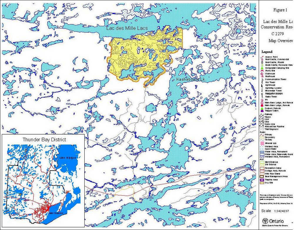
| Total Area (ha) | 2,537 hectares |
| Regulation Date | Anticipated in 2003 |
| First Nations | Treaty 3 Area and Robinson Superior . Lac des Mille Lacs IR 22A1 is the closest reserve. |
| OBM | 20 15 6800 54000 |
| Latitude/Longitude | 48° 08' N 89° 46' W |
| Base map | 486902 / 487902 (NTS – 52A/9 –Scale 1:50,000) |
| General Location Description | 100 kilometers northwest of Thunder Bay on the south shore of Lac des Mille Lacs. |
| Access | Boat access from Lac des Mille Lacs. Secondary and tertiary roads provide limited access at the south end. |
1.1 Targets
Earth science representation:
Bedrock: This site is located at the north margin of the Quetico metasedimentary Sub-province, of the Archean age Superior Province. Bedrock is mostly granitic, having been derived through partial melting of the meta-sedimentary migmatites which outcrop along the lakeshore. The boundary separating the Quetico and Wabigoon Sub-province (to the north) in this area is marked by the Quetico fault, a >400 km long major transcurrent fault.
Surficial: There appears to be a thin loamy till veneer over and between bedrock ridges through the interior of this site, with more extensive hummocky moraine and loess mapped in the east part, and some esker and kame formations in the west. No exposures of unconsolidated material were observed.
Life science representation:
Deciduous forest on weakly broken aeolean and beach deposits is considered critical to meet representation targets. Deciduous forest occurs in scattered small patches throughout the Conservation Reserve
Cultural resources representation:
The reserve includes a historic logging camp on the west end of Home Lake. No other features have been identified.
Recreational opportunities:
Opportunities exist for hunting. The site also offers access to sport fishing on Home and Camp Lake and on the southern shoreline of Lac des Mille Lacs. Remote tourism could be feasible on the inland lakes.
| Survey Level | Earth Science | Life Science | Cultural | Recreation | Other |
|---|---|---|---|---|---|
| Reconnaissance | Completed 2001 | Completed 2001 | Completed 2001 | ||
| Detailed | Not required | Not required | Not required | Not required |
2.0 Values to be protected
This section provides a description of the key natural heritage values on the site, and their condition relative to past resource use as well as sensitivity to future land use and management activities.
Life science
This site was identified for protection based on its representation of vegetation and landform types found throughout Ontario. Critical representative vegetation types produced by forest fire dynamics are absent from the reserve.
Camps Lake is a coldwater lake containing lake trout. Home Lake is a coldwater lake containing whitefish. Lac des Mille Lacs is a warmwater lake containing a regionally significant walleye fishery. It is popular fishing lake and the shoreline in the Conservation Reserve is used occasionally by boaters for shore lunches. There is no evidence of negative impacts from these uses on the ecological integrity of the site.
The Lac des Mille Lacs shoreline, small lakes and fens within the conservation reserve contribute to the variability to the landscape.
Earth science
The features of this site are generally resistant to damage by natural processes or landscape alteration activities although high water levels in Lac des Mille Lacs reduces the quantity and quality of bedrock exposure.
Recreational values
Although there is only two potential water routes through the site, this feature contributes to the site’s recreational potential. Potentially, Camp Lake can also be used as a water route by boaters and canoeists to reach the portages to both Kashabowie and Home Lakes. The area offers opportunities for summer camping, as there are three established campsites on Camp Lake. Most of these sites appear to be used regularly and are in excellent condition. The interior of the conservation reserve may attract enthusiasts who are in search of a short, yet reasonably remote, canoeing experience.
3.0 Management guidelines
All management activities must conform to the stated intent and direction of this Statement of Conservation Interest. New activities, which conform, must also be assessed for potential impacts on resource values. Values, which have been identified, should not be negatively impacted.
Management Activities are also subject to the requirements of the Environmental Assessment Act.
3.1 Land tenure
There are no crown patent lots within or adjacent to the Conservation Reserve.
No private recreation camps exist and no new ones will be permitted.
New transmission lines, pipelines, highways, and road corridors are not permitted. No dispositions including Land Use permits or Licenses of Occupation will be issued for industrial purposes. Land use authority excluding sales or lease may authorize permitted uses.
Any unauthorized occupations of lands within the conservation reserve will be managed in accordance with approved policy.
3.2 Existing / proposed development
There are no existing privies, boat launches, parking lots or waste disposal sites. Informal campsites exist. There are portages that link Home and Camp Lake to Kashabowie Lake.
There are several abandoned buildings adjacent the north west shore of Home Lake These are the remains of an old logging camp which existed approximately 30 to 40 years ago.
At present, one logging road on the Southeast side of Camp Lake provides the only means of land access. Access ends at the north side of Kashabowie River where a foot trail and water route exists to Camp Lake. This access point is a popular boat cache for private and commercial activities in the area. Bowater’s water crossing (2223617 located at the Kashabowie River) is scheduled for removal.
New development such as campsites, parking lots, and privies will not be considered unless a demand for such recreation facilities becomes apparent and a more detailed management plan is prepared.
3.3 Recreation activities
Recreational uses such as hunting, fishing, camping, hiking, wildlife viewing and snow shoeing will be allowed to continue within the Conservation Reserve.
Mechanized travel is permitted on existing roads and trails. ATV's and snowmobiles may also be used for the direct retrieval of game. New trails may be considered where compatible with other recreational uses and environmental values.
3.4 Commercial activities
The conservation reserve encompasses two active trap lines and two bait fish harvest areas. These uses will continue to be permitted with the condition that no new trails or other development will be allowed without specific authorization. New baitfish and commercial fur harvest operations can be considered. There are currently no trap cabins within the Conservation Reserve, and no new ones will be permitted.
The site also falls within an active bear management Area. Existing baitfish and bear management licenses that become vacant may be re-issued. New licenses will be considered on a case-by-case basis.
Timber harvesting, mining, aggregate extraction and commercial hydroelectric development are not permitted.
Applications for a tourism establishment may be considered on either Home or Camp Lake.
The conservation reserve area will be removed from the license area of the Dog River Matawin Forest.
3.5 Aboriginal interests
No aboriginal values within the conservation reserve have been identified at this time. Aboriginal and treaty rights will continue to be respected. Should more information become available it will be incorporated.
3.6 Natural resource stewardship
3.6.1 Vegetation management
The life science report concludes that approximately ¾ of the reserve is over mature conifer mixed wood forest. A good portion of this forest consists of dead balsam fir. The last fire in the 1930's burnt only 300 hectares of forest on the east side of the forest. Full fire suppression will perpetuate this cycle. Until alternative fire policies have been developed through a planning process, forest fire suppression policies will be similar to adjacent Crown lands. High forest values and recreational values adjacent to the reserve precludes the use of natural fire for vegetation management. Prescribed burning may be an option to consider as a management tool.
Forest fire protection will be carried out on the Conservation Reserve with a "light on lands" approach (i.e. no bulldozers, no camp construction, minimal tree cutting).
The control of insects and diseases will be addressed on a case-by-case basis and will be consistent with those as on the adjacent forest.
3.6.2 Fisheries and wildlife management
Fish and wildlife within the conservation reserve will continue to be managed in accordance with policies and regulations prevailing in the area. Sport fishing and hunting will continue as permitted uses within the conservation reserve.
3.6.3 Landforms
The landforms represented within this Conservation Reserve will not be altered through any landform modification activities such as trail development. The extraction of aggregates, peat, soils or any other similar materials will not be permitted.
3.7 Cultural resources stewardship
Any culturally significant sites within the conservation reserve remain unidentified at this time. The Ministry of Natural Resources will work with the Ministry of Tourism, Culture and Recreation in identifying archaeological sites that should be protected.
3.8 Client services
Thunder Bay District and the Information Management staff will be the primary contact for responding to inquiries about the basic level of information such as boundary locations, access, permitted uses, natural heritage appreciation and wildlife viewing opportunities.
3.9 Research
Scientific research by qualified individuals that will contribute to the knowledge of natural and cultural history and to environmental and recreational management will be encouraged.
All research programs will require the approval of the Ministry of Natural Resources and will be subject to ministry policy and other legislation. The ministry may approve the removal of any natural or cultural specimen by qualified researchers. All such materials removed remain the property of the Ministry of Natural Resources.
Approved research activities and facilities will be compatible with the protection objectives. Permanent plots or observation stations may be established to which researchers can return over time. Any site that is disturbed will be rehabilitated as closely as possible to its original state.
3.10 Marketing
Marketing efforts to increase use are not a priority and will be kept to a minimum. A fact sheet has been produced and is readily available to the public via either the Internet or through contact with the Thunder Bay District office.
4.0 Implementation
Implementation of this Statement of Conservation Interest will primarily involve monitoring activities to ensure adherence to the management guidelines.
Management of the conservation reserve is the responsibility of the Shebandowan Area Supervisor.
5.0 Review and revisions
The Lac des Mille Lacs Conservation Reserve Statement of Conservation Interest will be reviewed on an ongoing basis. If changes in management direction are required at any time, the significance of those changes will be evaluated. Minor changes that do not alter the overall protection objectives may be considered and approved by the area supervisor without further public consultation and the Statement of Conservation Interest would be amended accordingly. In assessing major changes, the need for a more detailed Conservation Management Plan will first be considered. Where a management plan is not considered necessary or feasible, a major amendment may be considered with public consultation. Major amendments will require approval by the Regional Director.
6.0 Public consultation
6.1 Results of past consultation
Consultation on the proposed Lac des Mille Lacs Conservation Reserve was conducted as part of the consultation associated with the Ontario’s Living Legacy Land Use Strategy from 1997 through to 1999. Subsequent consultation for the purpose of boundary refinement was held from June 15 – July 15, 2001.
Consultation efforts involved the mailing of District Manager letters and information packages to adjacent landowners, local First Nations, forest industry (SFL holder), the Local Citizens Committee, local trappers, Bear Management Area and Baitfish license holders as well as the Northwest Ontario Sportsman’s Alliance and any other affected or interested parties. Newspaper advertisements were placed in Thunder Bay’s Chronicle Journal as well as the Thunder Bay Post.
6.2 Present and future consultation
Treaty 3 consultation has been completed.
7.0 References
Harris, Allan and Foster, Robert. Lac Des Mille Lacs Life Science Checksheet, November 2001
Harris, Allan and Foster, Robert. Lac Des Mille Lacs Earth Science Checksheet, November 2001
Ontario Ministry of Natural Resources. Lac des Mille Lacs Lake Management Plan, 1992
Ontario Ministry of Natural Resources, Ontario’s Living Legacy Land Use Strategy. Queen’s Printer for Ontario, Ontario, Canada, 1999.
Figure 1: Overview Map
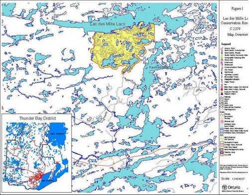
Enlarge Figure 1: Overview Map
Figure 2: Values Map