Lac Seul Islands Conservation Reserve Management Statement
This document provides policy direction for the protection, development and management of the Lac Seul Islands Conservation Reserve and its resources.
Statement of Conservation Interest
Sioux Lookout District
Ministry of Natural Resources
January 2005
Prepared by:
Magdalena Kowalczyk
Approval statement
I am pleased to approve this Statement of Conservation Interest for the Lac Des Mille Lacs Conservation Reserve.
This Statement of Conservation Interest will provide guidance tor the management of the conservation reserve and the basis for the ongoing monitor ng of activities. More detailed direction at this time is not anticipated. Should significant facility development be considered or complex issues arise requiring addional studies.more defined management direction, or special protection measures, a more detailed Conservation Reserve Management Plan will be prepared with full public consultation.
The public was widely consulted during the regulation process tor this conservation reserve and further consultation is not required at this time.
The conservation reserve will be managed under the jurisdiction of the Shebandowan Area Supervisor, Thunder Bay District, Ministry of Natural Resources.
Signed By:
W.D. Baker
District Manager
Thunder Bay District
Date: November 20, 2002
Charlie Lauer
Regional Director
Northwest Region
Date: December 12, 2002
1.0 Background information
The Ontario Ministry of Natural Resources has established Conservation Reserves as a new tool to offer protection for natural heritage areas on public lands, while permitting many traditional public land uses to continue.
The purpose of this Statement of Conservation Interest (SCI) is to identify and describe the values of the Lac Seul Islands Conservation Reserve (C2317). The SCI also outlines the activities that occur within the Conservation Reserve and provides guidelines for the management of current and future activities in the context of protecting the natural, social and cultural values of the Conservation Reserve.
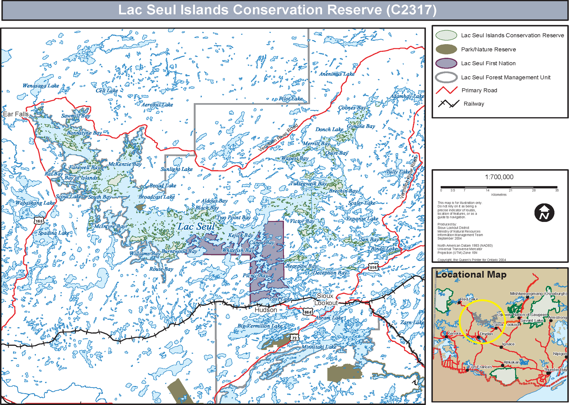
On May 21, 2003 the Lac Seul Islands Conservation Reserve (the Conservation Reserve) was formally regulated under the Public Lands Act. The Conservation Reserve includes approximately 985 islands found within the Lac Seul waterway system and is composed of approximately 14,723 hectares of Crown land. This site includes all Crown land islands in Lac Seul with the exception of Big Island and Reserve Island.
The Conservation Reserve is located entirely within the administrative District of Sioux Lookout, where both Lac Seul and Conservation Reserve management are administered. Neighbouring Districts of Red Lake and Dryden share enforcement duties on Lac Seul with Sioux Lookout District.
Lac Seul has a total surface area of 1,450 km², and is the second largest lake located entirely within Ontario. While not within the boundaries of the Conservation Reserve, Lac Seul has a profound influence on, and very strong ecological links to, the terrestrial habitats and species of the Conservation Reserve. The islands in the Conservation Reserve were affected in various ways when the Lac Seul reservoir was flooded in 1929 following the completion of the Ear Falls hydroelectric dam. New islands were created, some islands were flooded, while others became smaller.
In 1984, the Ontario Ministry of Natural Resources (OMNR) completed the Lac Seul (Lake) Management Plan. The Plan established a management strategy based on 7 management zones. After obtaining new information from a lake-wide angler survey, it was revised in 1986. The primary objectives of the Lac Seul (Lake) Management Plan are to recognize and protect the remote recreational character of the lake, to maintain the existing high quality of sport fishery on the lake, and to balance the annual fish harvest with annual fish productivity. Decisions made in the Conservation Reserve will be consistent with the Lac Seul (Lake) Management Plan.
The following Table outlines the basic information regarding the Conservation Reserve.
| Name | Lac Seul Islands Conservation Reserve (C2317) |
|---|---|
| Site Region / Site District | 3S-1 / 4S-2 |
| OMNR Administrative Region / District Area | Northwest Region / Sioux Lookout District |
| Total Area | 14,723 ha |
| First Nations | Lac Seul First Nation |
| General Location Description | Located approximately 400 km northwest of the City of Thunder Bay. Lac Seul is adjacent to the Municipality of Sioux Lookout and the Lac Seul First Nation Community, and extends westerly to the Municipality of Ear Falls |
| Access | Public Access points to Lac Seul include: Williams Bay, Deception Bay, Bindo (Causeway) Lake, English River, Sen Bay, Lost Lake, Billy B and Goldpines. |
| Latitude / Longitude | 50° 30' N 92° 00' W |
1.1 Representation targets
This section provides a summary of the earth and life science values, cultural resource and recreational opportunities available or possible within the Conservation Reserve.
Life science representation
The flora and fauna identified within the area during the Reconnaissance Inventory are:
- Old growth red and white pine stands
- Good representation of conifer-dominant forests and mixed deciduous forests on weakly broken lacustrine sediments
- Red-necked grebes were observed in the Conservation Reserve and are possible breeders in the area
- Osprey and bald eagle, considered endangered by the Committee of the Status of Species at Risk in Ontario (COSSARO), are known to nest in the Conservation Reserve
- The islands of Lac Seul are considered a regionally significant woodland caribou calving area
Earth science representation
The landform types identified during the Reconnaissance Inventory and the Recreation Inventory are:
- The sand dune bluffs in the Conservation Reserve expose excellent sections through glaciolacustrine and glaciofluvial deposits
- There are good outcrops exposed in the Conservation Reserve which show representative examples of all rock types associated with the English River and Winnipeg River Sub provinces of the Superior Province
Cultural resource representation
The Conservation Reserve was not selected for its cultural resources, however some important features are found within its boundary. The documented use of Lac Seul as a transportation route and the cultural significance of some of the islands suggest that this is an area rich in both culture and history. All of the islands in the Conservation Reserve are part of the Lac Seul First Nations traditional land, and some have been identified as sacred lands with spiritual legends attached to them. Archaeological sites can be found on the shorelines of the islands that were historically settled by First Nation People.
Recreational opportunities
Fishing is the most popular recreational activity on Lac Seul. However, Lac Seul and the Conservation Reserve also provide excellent opportunities for boating, bird watching, camping, houseboat activities, nature activities, wildlife viewing, beach activities and sport hunting.
1.2 Survey information
The following table provides an overview of the inventories completed, their level of detail and any further inventories that are needed.
| Survey Level | Reconnaissance | Detailed |
|---|---|---|
| Life Science | Completed 2001 | Not required |
| Earth Science | Completed 2001 | Not required |
| Cultural | Completed May 2002 | |
| Recreational | Completed January 2002 |
2.0 Values to be protected
This section provides a description of the key values on the site, their condition relative to past resource and management activities, and their sensitivity to future land use and management activities.
Cultural
A number of cultural sites are present.
Aboriginal
Trapping, traditional hunting and gathering.
Tourism
A number of outpost camps, boat caches and house boat operations exist on the shorelines of Lac Seul. Campsites and picnic areas have been identified in the Conservation Reserve.
Recreational fishing
No fishing opportunities exist within the Conservation Reserve.
However, Lac Seul is a popular fishing destination known for its walleye and trophy size musky and pike.
Mining
No active claims, staking or exploration within the site boundaries.
Aggregate
Aggregate was identified within the Conservation Reserve boundaries.
Forest harvest
Merchantable wood was identified in the Conservation Reserve.
Wild rice
None observed on site.
Trapping
The Conservation Reserve is part of 29 traplines.
Wildlife
Habitat conditions exist for a variety of species such as caribou, furbearers and a number of bird species.
Commercial fishing
There are four commercial whitefish licences on Lac Seul.
Bear Management Area
Part of active Bear Management Areas.
The bullet points below describe other values within the boundaries of the site which needed further explanation apart from the table.
- Recreation Values - The Conservation Reserve offers beautiful scenery, a sense of isolation and history, sand beaches that support a variety of recreational opportunities, plant and wildlife viewing, and sport fishing and boating on Lac Seul
- Cultural Values - Lac Seul First Nation has identified traditional habitation sites, sacred sites and grave sites in the Conservation Reserve. Members of the Hudson Legion have erected nine cairns to honour nine local men who died while fighting in World War II. Two of these are located on points of the mainland and the other seven were placed in the Conservation Reserve. All locations were selected by family members and named in their honour. Most of these men worked on Lac Seul transporting supplies for the gold mines, in Red Lake and Pickle Lake
- Forest Values - The entire forested area is to be protected from human disturbance. The forest cover in the Conservation Reserve is representative of Boreal forest ecosystem.
3.0 Management guidelines
All management activities must conform to the stated intent and direction of this SCI. New activities which conform must also be assessed for their impacts and ensure the resource values which have been identified, or which may be identified in the future, are not unduly impacted. Some management activates are subject to the requirements of the Environmental Assessment Act.
The management guidelines in this section are governed by the general policies contained in the Land Use Strategy (1999), existing Conservation Reserve Policy (1997), and by the direction in the Lac Seul Management Plan with input from the Lac Seul Advisory Committee. Any new uses, and commercial activities associated with the Conservation Reserve, will be considered on a case by case basis, and must pass a 'test of compatibility' (Appendix A) to be acceptable.
3.1 Land tenure
The Conservation Reserve consists entirely of Crown land and no disposition of Crown land by sale is permitted within the Conservation Reserve. New leases or Land Use Permits may be considered for approved activities, subject to the 'test of compatibility'.
3.2 Existing and proposed development
One of the most important uses of Lac Seul is its role in the generation of power, both at the Ontario Hydro dam at Ear Falls and at the seven hydro electric power stations located further downstream between Ear Falls and Lake Winnipeg. Lac Seul water levels are regulated by the Lake of the Woods Control Board, over an approved operating range of 4.8 m. The minimum permitted water level is 352.4 m, and the maximum 357.2 m. It is suspected that erosion caused by water level regulation is having a negative impact on the Conservation Reserve. The amount of erosion, its actual impacts, and the potential ways to mitigate its effects are unknown. It is suggested that the Lake of the Woods Control Board assist MNR and other resource users to fund research to examine the impacts that water regulation decisions have on the Conservation Reserve and other Lac Seul resource users. Existing hydroelectric dams at the outlet of Lac Seul are permitted to remain; there are no opportunities for new hydroelectric development within the Conservation Reserve.
Existing facilities in the Conservation Reserve include: a houseboat moorage under a Land Use Permit on Horseshoe Island and two trapping cabins (SL61-125, SL96-140, see NRVIS data), which are permitted to continue. There are also several campsites and picnic areas located in the Conservation Reserve.
3.3 Recreational activities
Recreational activities that have traditionally been enjoyed in the Conservation Reserve can continue, provided they pose no threat to the natural ecosystems and features protected by the Conservation Reserve. Permissible activities include: viewing, hunting, fishing, canoeing, and resident Crown land camping. In 1985, Lac Seul was designated as a restricted camping zone. Therefore, non-residents of Canada are not permitted to camp on Crown land within half a kilometre from the shore of Lac Seul and in the Conservation Reserve.
There are no authorized snowmobile or ATV trails within the Conservation Reserve and the extent of snowmobile and ATV use in the Conservation Reserve is not known. Trail development may be considered subject to the 'test of compatibility' (Appendix A). Off-trail use of snowmobiles and ATVs may occur for the direct retrieval of game.
3.4 Commercial activities
All commercial activities such as fur harvesting, bear management areas, tourism and commercial fishing licences that are established within the boundaries of the Conservation Reserve will continue to be permitted.
Existing commercial fur trapping and fishing are permitted to continue, provided that they do not have significant negative impacts on values being protected by the Conservation Reserve. New commercial fur trapping and fishing operations may be considered subject to the 'test of compatibility' (Appendix A).
Game hunting by residents will continue to be permitted. Existing authorized operations for non-resident (guided) bear hunting is permitted to continue. Transfer requests will be considered on a required basis. New operations are not permitted.
The Conservation Reserve has been permanently removed from the Lac Seul Forest Sustainable Forest Licence and has also been withdrawn from all mining exploration and extraction activities by the Ministry of Northern Development and Mines (MNDM).
Commercial timber harvest is not permitted within the Conservation Reserve. Cutting of trees by leaseholders, cottagers and other property owners for fuelwood and other small scale uses may be authorized by permit. The permit will be subject to a review of the impact that such cutting would have on protecting values. Intended uses of trees cut include fuelwood, dock stringers and other occasional, small-scale uses. This is not intended to allow large-scale cutting for building structures (log homes, etc). Timber salvage/sunken log retrieval of standing, fallen or sunken trees may be removed for resource conservation purposes (i.e. fishery rehabilitation). Such trees may be marketed if economical.
New activities such as mining, extraction of peat, soil, aggregate, or other materials are not permitted.
3.5 Aboriginal interests
Local First Nations were asked to provide input to the regulation of the Conservation Reserve. The members of the Lac Seul First Nation expressed their concerns regarding the removal of archaeological artifacts and the amount of garbage left on sacred/cultural sites. In an effort to clean up the islands, in August 2001 a group of Ontario Rangers and MNR employees cleaned up the Manitou Miniss Island. Lac Seul First Nation has provided supportive information which may be used if a more detailed resource plan for the Conservation Reserve should be developed.
The Conservation Reserve is located in part of the territory the Lac Seul First Nation and has traditionally been used for hunting, gathering, trapping and other activities. Traditional resource use by Aboriginal peoples for subsistence and ceremonial purposes will continue to occur in the Conservation Reserve, consistent with Treaty and Constitutional rights. Such activities may continue with consideration for public safety and conservation objectives.
By raising visitor awareness through education, the MNR working with the Lac Seul First Nation and tourism outfitters can promote the culture and rights of First Nations people, as well as address the removal of archaeological artifacts from sacred sites and littering concerns on the islands.
3.6 Natural resource stewardship
3.6.1 Vegetation management
Forest fires are an important ecosystem process fundamental to restoring and maintaining ecological integrity. Many of Ontario’s ecosystems, including those represented in the Conservation Reserve, have adapted to disturbance by fire for renewal and ecological health. Natural fire regimes contribute to ecological integrity through maintaining a shifting mosaic of healthy vegetation patches.
Under previous fire management strategies, the Conservation Reserve was part of the Intensive Protection Zone in which all fires generally received a full response and sustained action (if required) until extinguished. Under the Forest Fire Management Strategy for Ontario, the Conservation Reserve is included in the Boreal Fire Management Zone. This zone remains associated with an intensive level of protection and all fires will generally receive a full response.
Unfortunately, long-term fire suppression can produce significant accumulations of biomass that function as fuels. Fires in altered, ecosystems are associated with an increased risk of extreme fire behaviour that can threaten lives, property, neighbouring lands, as well as natural and some cultural features.
Lack of fire disturbance in the last century in other areas of Ontario has resulted in ecosystem conditions that do not represent the forest, savannah, or grassland conditions before modern intervention. Shifts in species composition, accumulations of biomass, insect infestations, poor regeneration, and degradation of wildlife habitat are examples of changes that have been documented. Protected areas, such as the Conservation Reserve, containing fire dependent ecosystems will not continue to represent the ecosystems they were designed to protect unless exposed to fire in the coming decades.
The Fire Management Policy for Provincial Parks and Conservation Reserves states that fire management direction for conservation reserves that is alternate to the fire management strategy may be provided through an approved fire management plan. A fire management plan must specifically address objectives and prescribed actions with respect to both fire response and fire use that will support the vegetation management objectives of the park or conservation reserve.
Permitting traditional public uses to continue while protecting the representative natural heritage, is the primary objective of the Conservation Reserve. Forest Fires have been and will continue to be a significant ecosystem process fundamental to restoring and maintaining the integrity of the ecosystems represented in the Conservation Reserve. To protect and maintain the representative natural heritage of the Conservation Reserve, a fire management plan will be prepared in accordance with approved planning processes.
Until a fire management plan is approved, however, fires will receive a response in accordance with an approved Interim Fire Response plan. As directed in the interim response plan, all fires will receive a response commensurate with values at risk and fire program capacity. Fires that threaten human life, property and other values will generally receive a full response. All other fires will have a fire assessment report completed, and will be monitored to ensure they do not threaten human life, public safety or currently identified values. If a fire threatens human life and/or property, full and/or modified response and values protection will be used until the threat has passed. Action will then revert to monitoring the fire.
Whenever feasible, the MNR fire program will endeavour to use "light on the land" suppression techniques, which do not unduly disturb the landscape, in this Conservation Reserve. Examples of light on the land techniques may include limiting the use of heavy equipment or limiting the number of trees felled during fire response efforts.
Opportunities for prescribed burning to achieve ecological or resource management objectives may be considered. Prescribed burn objectives will be consistent with the management direction for the Conservation Reserve. Plans for any prescribed burning will be developed in accordance with the MNR Prescribed Burn Planning Manual, and the Class Environmental Assessment for Provincial Parks and Conservation Reserves.
3.6.2 Fish and wildlife management
No management action is required, other than the implementation of existing Wildlife Management Unit, Sport Fishing Regulations and management activities. New featured-species management (e.g. construction of Osprey nests) may be permitted in the Conservation Reserve subject to the 'test of compatibility' (Appendix A).
3.6.3 Landforms management
The landforms represented within the Conservation Reserve will not be altered through any landform modification activities, including filling and extracting of aggregates, peat, soil and any other similar materials. Erosion effects on the Conservation Reserve should be monitored and where appropriate active management should be taken.
3.7 Cultural resources stewardship
Various archaeological reconnaissance activities have taken place Conservation Reserve, mainly by Wright (1962-1965), Lambert (1980-1982), Wall (1978-1979) and Brad Hyslop (1980-present). All identified archaeological and historic sites within the Conservation Reserve will be protected from adverse impact. MNR will continue to work with Heritage Planners within the Ontario Ministry of Culture to ensure that the list and locations of such sites is current and accurate, and that protection measures in place are adequate for all values present. In order to protect the cultural heritage sites their locations within the Conservation Reserve are considered confidential.
3.8 Client services
To ensure that all resource users are aware of the Conservation Reserve location, access points and permitted uses information will be provided at the Sioux Lookout District Office.
3.9 Research
Science research by qualified individuals that will contribute to the knowledge of natural and cultural history and to environmental and recreational management will be encouraged.
All research programs will require the approval of the Ministry of Natural Resources and will be subject to Ministry policy and other legislation. The Ministry may approve the removal of any natural or cultural specimen by qualified researchers. All such materials removed remain the property of the Ministry of Natural Resources, or other agency as appropriate.
Approved research activities and facilities will be compatible with the protection objectives of the Conservation Reserve. Permanent plots or observation stations may be established to which researchers can return over time. Any site that is disturbed will be rehabilitated as closely as possible to its original state.
3.10 Marketing
Marketing efforts to increase use are not a priority and will be kept to a minimum. A fact sheet for the Conservation Reserve has been produced and is readily available to the public by request to the Sioux Lookout District office.
4.0 Implementation
The SCI will be implemented by the Sioux Lookout District, working in partnership with the Lake of the Woods Control Board and other stakeholders. Any MNR Resource Management Plans or Land Use Plans which include this area will be amended accordingly. Any affected clients will be immediately informed of the changes, should any arise. Administrative responsibility for the Conservation Reserve rests with the Sioux Lookout MNR District Manager. Implementation will primarily involve monitoring activities to ensure adherence to the SCI, and will include:
- With the support of the Lake of the Woods Control Board examining the impacts that water regulation decisions have on the Conservation Reserve and other Lac Seul resource users
- Develop a fire management plan to protect and maintain the representative natural heritage of the Conservation Reserve
- With the support of the Lake of the Woods Control Board monitor erosion effects on the Conservation Reserve and take appropriate management action where required
5.0 Review and revision
The Conservation Reserve SCI will be reviewed on a required basis. If changes in management direction are required at any time, the significance of those changes will be evaluated. Minor changes that do not alter the overall protection objectives may be considered and approved by the District Manager without further public consultation and the SCI would be amended accordingly. In assessing major changes, the need for a more detailed Conservation Management Plan will be considered. Where a Conservation Management Plan is not considered necessary or feasible, a major amendment to the SCI may be considered with the appropriate public consultation. Major amendments will require the approval of the Regional Director.
5.1 Public consultation
5.1.1 Results of past consultation
Consultation on the proposed Conservation Reserve was conducted as part of the consultation associated with the Ontario’s Living Legacy Land Use Strategy from 1997 through 1999. Public consultation for the Lac Seul Island Conservation Reserve was held from June 15, 2001 to July 15, 2001. Consultation efforts involved the mailing of District Manager letters and information packages to stakeholders, local First Nations, forest industry (Sustainable Forest License holders), the Local Citizens Committee, the Lac Seul Advisory Committee, local commercial fur harvesters and Bear Management Area licence holders. A Newspaper advertisement was placed in the Sioux Lookout Bulletin and the Wawatay News. Three written responses and one verbal response were received from public consultation. Meetings were held with Lac Seul First Nation communities of Frechman’s Head (August, 2001 and November 22, 2001), Kejick Bay (August 2001), and Whitefish Bay (October 11, 2001). A presentation regarding the Conservation Reserve was presented to the Lac Seul Advisory Committee Members on October 17, 2001. A report prepared by Keeshikoong Consulting provided a number of recommendations to the MNR with regards to the Conservation Reserve.
5.1.2 Present and future consultation
The public was widely consulted in 2001, and there is no reason for further consultation on the Conservation Reserve at this time. Future public consultation may be required if major amendments to the SCI arise, see the Review and Revision section for details on these requirements.
6.0 References
Combot, Nicole. Recreation Assessment Report for the Lac Seul Islands Conservation Reserve, 2002.
Foster, R. and Allan, Harris. Lac Seul CR Draft Life Science Inventory Checksheet. Northern Bioscience, 2001.
Keeshikoong Consulting. Kenny, George & Kenny, Mary Bea. Lac Seul First Nation Statement of Conservation Interest, 2002.
Ministry of Natural Resources. Conservation Reserves Policy and Procedure (PL 3.03.05). 1997
7.0 Maps
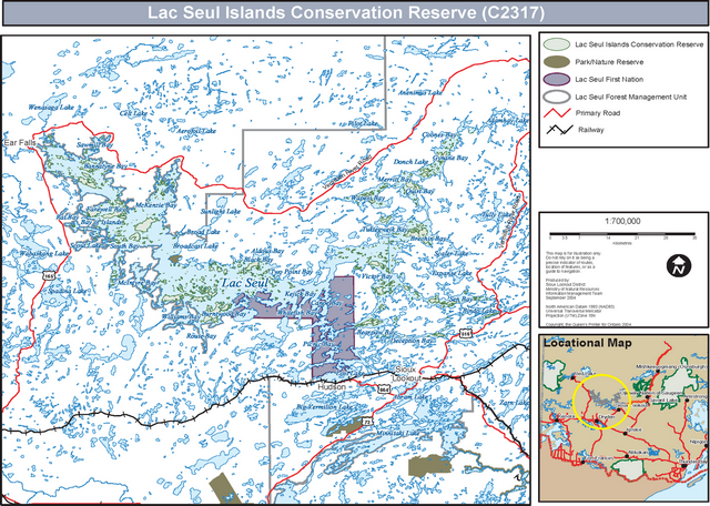
Enlarge: Lac Seul Islands Conservation Reserve (C2317) Map
Appendix A
Land Use - Test of Compatibility
The Statement of Conservation Issues describes values for which an area has been set aside and the range of appropriate uses that will be permitted in the area. The Statement of Conservation Issues may also speak to the acceptability of other 'new' uses currently not occurring in the area.
The first 'test' is: To identify if the proposed new land uses and /or commercial activities conform to the direction of the Statement of Conservation Issues for the conservation reserve? Would the new use(s) depart form the spirit of appropriate indicator land uses in the Statement of Conservation Issues?
The Impact Assessment: If the proposed use(s) pass the first test it is important to determine their impact on the area before they are approved. This should include the following:
- Impact on Natural Heritage Values: Will the new use(s) impact any natural values in the area? Is so how and to what degree? Is it tolerable?
- Impact on Cultural Values: will the new use(s) impact any historical or archaeological values in the area?
- Impact on Research Activities: Will the new use(s) affect any research activities in the area?
- Impact on Current Uses: Will the new use(s) have any negative impact on the array of current uses?
- Impact on Area Administration: Will the new use(s) increase administrative costs and/or complexity? (For example, the cost of area monitoring, security and enforcement).
- Impact of Accommodating the Use Outside the conservation reserve: Could the use(s) be accommodated as well or better outside the conservation reserve?
- Impact on Socio-Economics of the Area: Will the new use(s) affect the community(ies) surrounding the area in a positive or negative way? (For example, will the new use make the area less remote thereby affecting a local tourism industry that is dependent on the area’s remoteness for its appeal)?
- Impact on Area Accessibility: Does the new use(s) give someone exclusive rights to the area or a portion of the area to the exclusion of other existing uses?