Lake Nipigon Basin Signature Site Park Management Parent Plan for Lake Nipigon, Kabitotikwia River, Livingstone Point, West Bay and Windigo Bay provincial parks.
This document provides policy direction for the protection, development and management of Lake Nipigon, Kabitotikwia River, Livingstone Point, West Bay and Windigo Bay provincial parks and their resources.
Lake Nipigon Basin Signature Site Park Management Parent Plan
©2003 Queen’s Printer for Ontario
Printed in Ontario, Canada
Additional copies of this publication are available from the Ministry of Natural Resources at the following location:
Ontario Parks
Northwest Zone
Suite 221d, 435 James St. S. Thunder Bay, ON P7E 6S8
Phone:
or
Nipigon District Office
5 Wadsworth Drive
Nipigon, ON P0T 2J0
Phone:
51726
0.5k P.R. 30 04 04
ISBN- 0-7794-4015-3
July 2003
Dear Sir/ Madam:
I am pleased to approve the Lake Nipigon Basin Signature Site Park Management Parent Plan as the official policy for the protection and management of Lake Nipigon Provincial Park, Kabitotikwia River Provincial Nature Reserve, Livingstone Point Provincial Nature Reserve, West Bay Provincial Nature Reserve, and Windigo Bay Provincial Nature Reserve. The plan reflects the Ministry of Natural Resources’ and Ontario Parks’ intent to protect the natural and cultural features of these five parks, while maintaining and developing high quality opportunities for outdoor recreation and heritage appreciation for the residents of Ontario and visitors to the province.
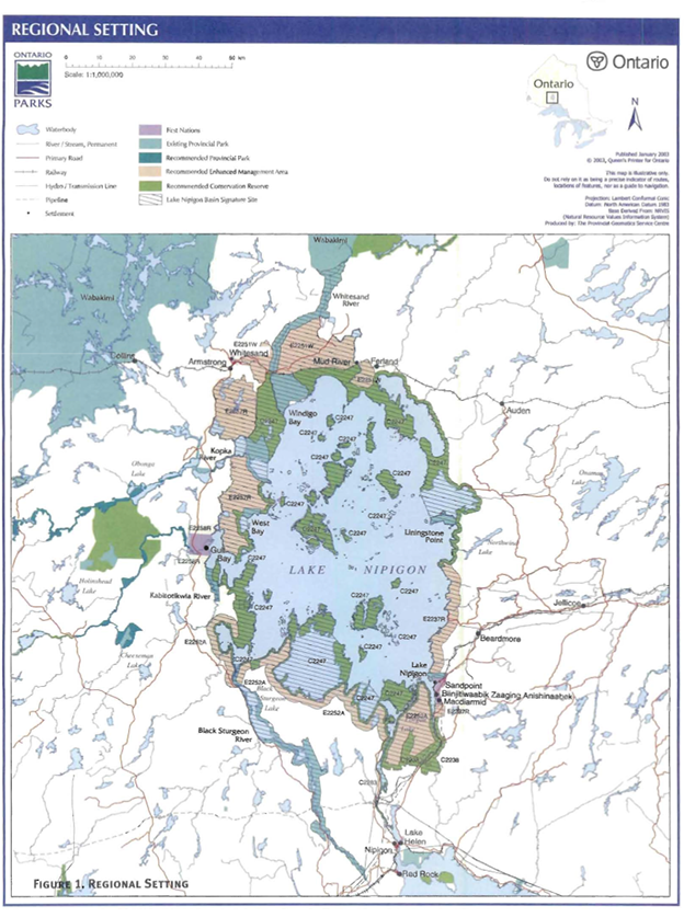
Lake Nipigon Provincial Park, Kabitotikwia River Provincial Nature Reserve, Livingstone Point Provincial Nature Reserve, West Bay Provincial Nature Reserve and Windigo Bay Provincial Nature Reserve are all located within the Lake Nipigon Basin Signature Site, one of 9 such areas featured in the Ontario’s Living Legacy Land Use Strategy (1999). Signature Sites are identified for their range of natural and recreational values and their potential to contribute to future recreation and tourism.
This management parent plan has been developed under the general direction of the Lake Nipigon Basin Signature Site Ecological Land Use and Resource Management Strategy, which provides the overall context for land use and resource management activities in the Basin.
The plan includes a prioritized implementation strategy and summarizes the public consultation that occurred as part of the planning process.
The park management parent plan will be used to guide the management of these five parks. It may be reviewed to address changing issues or conditions. A review will be held as required.
I wish to extend my sincere thanks to all those who participated in the public consultation process.
Yours truly,
Adair Ireland-Smith
Managing Director
Statement of Environmental Values and the Environmental Bill of Rights
In accordance with the provisions of the Environmental Bill of Rights, the Ministry of Natural Resources prepared a Statement of Environmental Values. It describes how the purposes of the Environmental Bill of Rights are to be considered whenever decisions are to be made which might significantly affect the environment. This includes decisions made as a result of the park management planning process.
The primary purpose of the Environmental Bill of Rights is “to protect, conserve and wherever possible, restore the integrity of the environment.” From the Ministry’s prospective, that broad statement of purpose translates into four objectives in its Statement of Environmental Values:
- To ensure the long-term health of the ecosystems by protecting and conserving our valuable soil, aquatic resources, forest and wildlife resources as well as their biological foundations;
- To ensure the continuing availability of natural resources for the long-term benefit of the people of Ontario;
- To protect natural heritage and biological features of provincial significance; and,
- To protect human life, the resource base and the physical property from the threats of forest fires, floods and erosion.
The Ministry’s Statement of Environmental Values has been considered in the development of the Lake Nipigon Basin Signature Site Provincial Park Management Parent Plan for Lake Nipigon Provincial Park, Kabitotikwia River Provincial Nature Reserve, Livingstone Point Provincial Nature Reserve, West Bay Provincial Nature Reserve, and Windigo Bay Provincial Nature Reserve.
1.0 Introduction
This parent plan has been prepared to cover the management need of the five Provincial parks located on the shores of Lake Nipigon because the parks are spatially, thematically and administratively related. The plan includes sufficient background information and analysis upon which to support planning decisions. This "parent plan" the force and effect of a full management plan. Where sufficient background inventory is not available to support. significant decision s, or in situations where further study or analysis is required, decisions were deferred to subsidiary plans as is the current practice.
As stated in the Environmental Bill of Rights posting the “goal of the Lake Nipigon Basin Project Team is to develop an Ecological Land Use and Resource Management Strategy for the Nipigon Basin that includes management plan for provincial parks and conservation reserves”.
The parks covered by this parent plan are components of the Lake Nipigon Basin Signature Site. The planning process for the Lake Nipigon Basin Signature Site is a complex initiative. A single process is being applied to the signature site, which contains a number of areas with different land use designation. The areas all share common planning stages and timelines, thereby facilitating the concurrent public consultation and planning process. The areas included within the Lake Nipigon Basin also share common geographic themes, recreation uses and resource issue with the various components of the signature site. The development of Lake Nipigon Basin Ecological Land Use and Resource Management Strategy will include the development of the management plans for parks including Black Sturgeon River Provincial Park, Lake Nipigon Provincial Park, Kabitotikwia River Provincial Nature Reserve, Livingstone Point Provincial Nature Reserve, Windigo Bay Provincial Nature Reserve, and West Bay Provincial Nature Reserve.
The parks addressed by this park management parent plan are Limited to the regulated park on the shores of Lake Nipigon and include:
- Lake Nipigon Provincial Park;
- Kabitotikwia River Provincial Nature Reserve;
- Livingstone Point Provincial Nature Reserve;
- Windigo Bay Provincial Nature Reserve; and
- West Bay Provincial Nature Reserve.
There are three remaining Provincial parks within the Lake Nipigon Basin Signature Site that are not included in the parent plan. The parks not covered by this parent plan are:
- Kopka River Provincial Park;
- Whitesand Provincial Park; and
- Black Sturgeon River Provincial Park.
The original Kopka river Provincial Park and additions will not be included in this process because the majority of the park is outside of the signature site boundary. The boundary of Kopka River Provincial Park, however, will be amended through the Lake Nipigon Basin Ecological Land Use and Resource Management Strategy process. Direction for Kopka River Provincial Park and additions will be considered during the park management planning process for the Kopka River and Wabakimi Provincial Parks. Whitesand Provincial Park will not be included in this planning process due to outstanding Aboriginal concerns. Black Sturgeon River Provincial Park is the subject of a separate park management planning process a part of the larger Lake Nipigon Basin planning initiative.
1.1 Lake Nipigon Provincial Park
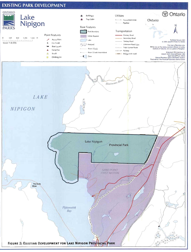
Lake Nipigon Provincial Park is 918 hectares in size and is located along the southeast shores of Lake Nipigon, between Highway 11 and the Lake Nipigon shore, approximately 100 kilometres southwest of Geraldton. The park was established in 1960 as Blacksand Provincial Park. In 1971, the area of the park was increased to include Lake Nipigon waters for a distance of 152 metres from shore (high water mark). The park name was changed in 1978.
The latest park management plan for Lake Nipigon Provincial Park was approved in 1988 and subsequently amended in 1997.
As part of the “Land and Larger Land Base Framework Agreement”, an area of 350 hectares was deregulated in August 1999 from Lake Nipigon Provincial Park and is being transferred to the federal government to form a new reserve for the Sand Point First Nation. Public input played an important role in making the final decision to remove land from Lake Nipigon Provincial Park. A major park management plan amendment was completed in spring 1997 as part of the deregulation. The balance of the park has retained its natural environment classification.
1.2 Kabitotikwia River Provincial Nature Reserve
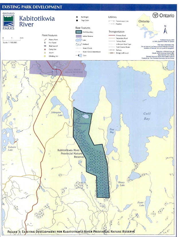
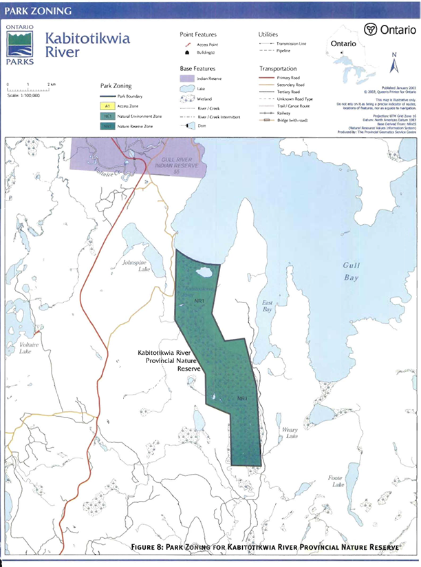
Kabitotikwia River Provincial Nature Reserve is a nature reserve class park (1,965 hectares) located on the west side of the Lake Nipigon Basin, on the southwest shore of Gull Bay.
The park contains a variety of wetlands, such as fluvial marsh, treed fen, and low shrub fen. The meandering Kabitotikwia River, which flows through the park, is part of an established canoe route in Nipigon District.
The park was regulated on January 15, 1985. An interim management statement for Kabitotikwia River Provincial Nature Reserve was revised in March 1991.
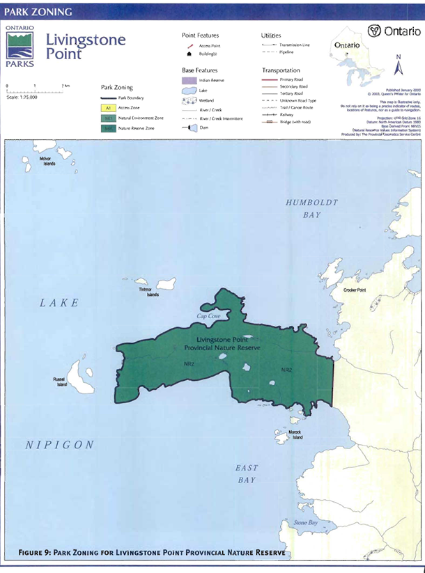
1.3 Livingstone Point Provincial Nature Reserve
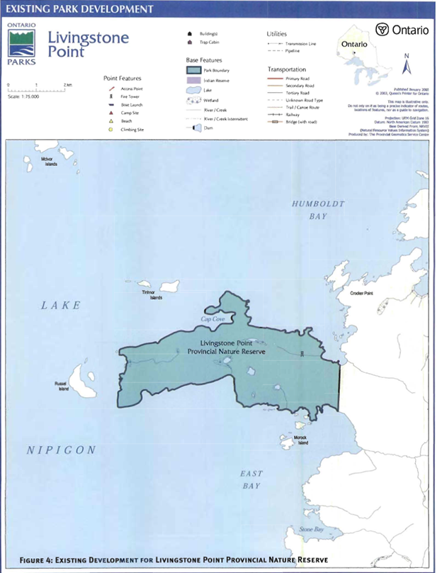
Livingstone Point is a nature reserve class park (1,800 hectares in size) located in the northeast quadrant of the Lake Nipigon Basin, south of Humboldt Bay. The major physiographic features include moderately to strongly broken uplands with shallow, sand till over bedrock, with lacustrine clay in valleys. The relief is variable with the highest and most rugged area in the central portion of the park, with large hills flanked by extensive talus boulder fields.
The park was regulated on February 16, 1985. An interim management statement for Livingstone Point Provincial Nature Reserve was revised in March, 1991.
An interim management statement for Livingstone Point Provincial Nature Reserve was revised in March, 1991.
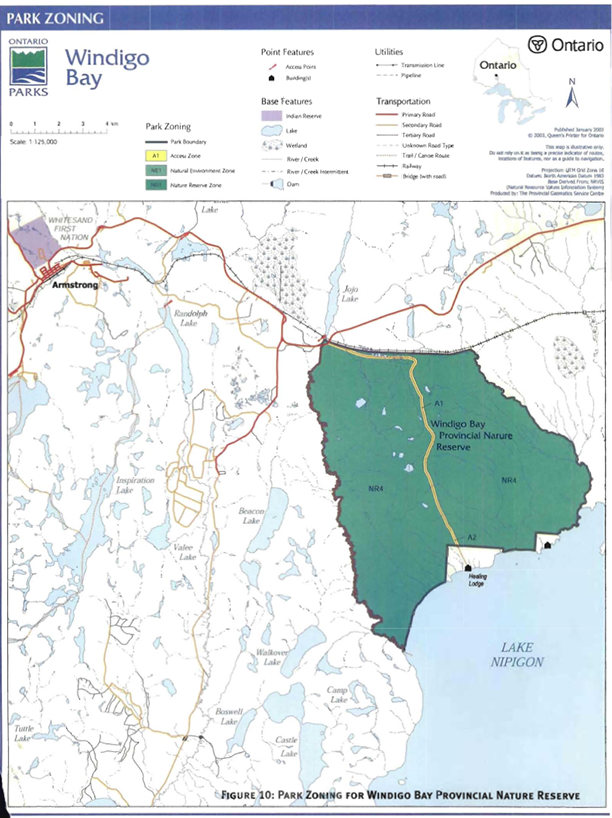
1.4 Windigo Bay Provincial Nature Reserve
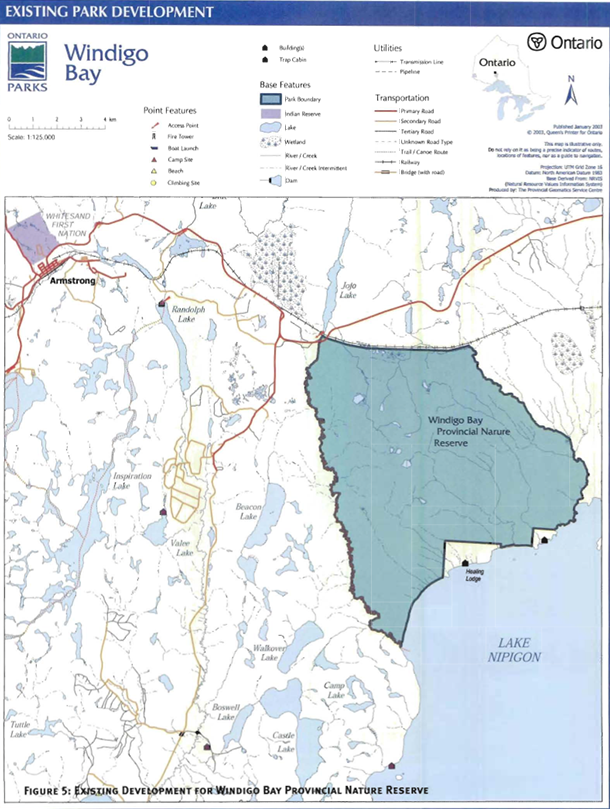
Windigo Bay is a nature reserve class park (8,378 hectares in size) located on the northwest shore of Lake Nipigon. It is bounded by the Whitesand River (on the west), the CN rail line (on the north), Kenna Creek (on the east) and Lake Nipigon (on the south). There is a small area adjacent to the east boundary of the park that is held by private tenure. An area around Mount St. John, where the “Old Whitesand” community was located until approximately 1940, is not included in the park. Windigo Bay protects a number of significant natural features including wintering range and migration corridor for woodland caribou.
The park was identified for its geological values and regulated on May 27, 1989.
The interim management statement for Windigo Bay Provincial Nature Reserve was revised in February, 1999. This revision reflected an agreement between Ontario Parks and Whitesand First Nation for the construction of a restricted access road by the First Nat ion for access to their healing lodge immediately west of Mount St. John.
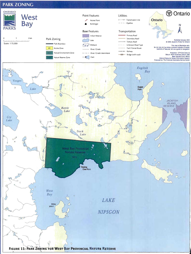
1.5 West Bay Provincial Nature Reserve
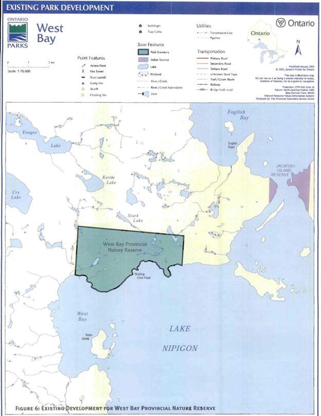
West Bay Provincial Nature Reserve is one of the smallest parks in the Lake Nipigon Basin with an area of 1,120 hectares. It is a nature reserve class park located on the west side of Lake Nipigon on the northern shore of West Bay.
There are some wetlands present and these are mostly graminoid or low shrub bogs developing in small kettle potholes. The dominant forest type is a deciduous shrub rich mixed-wood and overall the West Bay Provincial Nature Reserve environment is pristine, due to the difficulty of accessing this remote area.
The park was identified for it shoreline features of Lake Kelvin and sections of Onaman Interlobate Moraine. The park was regulated on February 16, 1985. An interim management statement for West Bay Provincial Nature Reserve was revised in March, 1991.
The Lake Nipigon Basin Signature Site Park Management Parent Plan has evolved from the public review of the following documents:
- Lake Nipigon Basin Background Document;
- Lake Nipigon Basin Signature Site Management Options; and
- Lake Nipigon Basin Signature Site Preliminary Park Management Parent Plan.
The background document and management option document includes information on all of the conservation reserves, enhanced management area and provincial park within the signature site. The preliminary park Management plan was specific to parks covered by the “parent plan”.
The approved Lake Nipigon Basin Signature Site Park Management Parent Plan sets direction for the next 20 years by establishing policy and identifying appropriate development, consistent with the goals and objectives of Ontario Parks.
2.0 Summary of significant issues (not ranked)
Park users local residents Spruce River/Armstrong Local Citizens Committee First Nations, Canadian Outward-Bound Wilderness School (COBWS) as well as other groups and individuals, identified the following concerns related to the management of Lake Nipigon Provincial Park, Kabitotikwia River Provincial Nature Reserve, Livingstone Point Provincial Nature Reserve, West Bay Provincial Nature Reserve, and Windigo Bay Provincial Nature Reserve.
2.1 Classification of Lake Nipigon Provincial Park
Lake Nipigon Provincial Park is a natural environment class park. According to park policy, natural environment parks should be at least 2,000 hectares or more in size. The park boundary was modified in 1997 to accommodate the establishment of the Sand Point First Nation. Now the park is 918 hectares in size. Some suggested the classification be changed to nature reserve. This consideration is addressed in section 3.0.
2.2 The use of motorized boats in Kabitotikwia River Provincial Nature Reserve
Kabitotikwia River Provincial Nature Reserve was established to protect the wetland complex south of Gull Bay along the Kabitotikwia River. Currently, anglers from Lake Nipigon use the area. There is evidence to suggest that the wakes from the angler motorized boats are negatively affecting the wildlife and vegetation in the park. Three options to deal with this issue were provided in the management options document. The first option proposed continuing the use of motorized boats in the park. The second option proposed restricting the use of motorized boat in the river, such that boat must travel through the park without creating a wake. The third option prohibited motorized boats from operating in the park.
The public supported a ban on motorized boats within the park. This consideration is addressed in more detail in section 7. 1.1 and 9.2.1.
2.3 Boundary expansions round Kopka River Provincial Park
Three potential expansions of Kopka River Provincial Park were proposed in the Lake Nipigon Basin Signature Site Management Options document as follows:
- Changing the designation of Wabinosh Bay from conservation reserve to Provincial park;
- Including the former Prisoner of War camp site, which was included within an enhanced management area; and
- Including portions of the conservation reserve on the east shore of Wabinosh Lake.
Some people were opposed to increasing the size of parks and protected areas, thereby decreasing the amount of area within the enhanced management area. The park boundary was adjusted to include all three of these areas. This concern is addressed in Chapter 1, Section 3.1.1 of the Strategy, because the park is not being planned for in this parent planning process.
2.4 Road restrictions in Windigo Bay Provincial Nature Reserve
Currently there is a healing lodge on the shore of Lake Nipigon, surrounded by Windigo Bay Provincial Nature Reserve. This spiritual centre and its associated cabins were built to provide emotional support and cultural development for the members of Whitesand First Nation. A road and trail were constructed through Windigo Bay Provincial Nature Reserve to provide land access to the Whitesand First Nation Healing Lodge. The project was subject to a field environmental planning process, which concluded in 1997. During that process, concerns were raised that the road and trail would disrupt the woodland caribou migration between the Wabakimi/Armstrong area and Lake Nipigon. The road use Memorandum of Understanding signed in 1998 between Whitesand First Nation and MNR/Ontario Parks will remain to guide the agreed timing and use parameters of the road through the park. These considerations are addressed in section. 5.1, 5.1.2, 7.2.1 and 7.2. 2.
3.0 Classification
The provincial parks system incorporates six classes of parks, which are selected to meet representation targets in addition to the protection of special values. Lake Nipigon Provincial Park retains its natural environment classification. Natural environment parks are selected to protect large, representative, and ecologically viable areas throughout Ontario. The target is to establish one natural environment park in each of the provinces’ ecological districts. All parks are included within and representative of ecoregion 3W and ecodistrict 3W-3 (Hills 1964; Crins 2000). All other existing parks in this parent plan are nature reserve class park. Nature reserve parks and zones are established to represent and protect Ontario’s geological, ecological, and species diversity.
4.0 Goal
The five provincial parks on the shores of Lake Nipigon contribute to the provincial parks system by protecting such values as plant communities, wildlife, and cultural resource, providing recreational opportunities for heritage appreciation and tourism benefits. These five parks will contribute to resource protection in the region.
In accordance with each parks’ classification, the goal of the five parks within this parent plan is:
To protect the significant natural, cultural, and recreational features, while providing opportunities for visitors to participate in non-consumptive and compatible heritage appreciation, recreation, and tourism activities.
These parks contribute to the goal of the provincial park system, which is:
To provide a variety of outdoor recreation opportunities and to protect provincially significant natural, cultural and recreational environments in a system of provincial parks.
5.0 Objectives
Ontario’s provincial park system has four objectives: protection, recreation, heritage appreciation, and tourism. Each park in the system contributes in one way to each of these objective, depending on its resource base. Each park in the basin contributes to the achievement of all four objectives.
The four key objectives are:
- Protection: To protect provincially significant elements of the natural and cultural landscape of Ontario;
- Recreation: To provide outdoor recreation opportunities ranging from. high-intensity daily-use to low-intensity wilderness experiences;
- Heritage Appreciation: To provide opportunities for exploration and appreciation of the outdoor natural and cultural heritage of Ontario; and
- Tourism: To provide Ontario’s residents and out -of province visitors with opportunities to discover and experience the distinctive regions of the province.
5.1 Protection objective
To protect the provincially significant natural features in the parks including arctic-alpine disjunct plants and communities, bald eagles, woodland caribou populations as well as representative ecosystems and potential cultural sites.
These five parks contain a variety of natural and cultural resources that are provincially significant. These include:
- Arctic-alpine disjunct plants and communities (Livingstone Point);
- Woodland caribou wintering range (Livingstone Point and Windigo Bay);
- Marsh complex (Kabitotikwia River);
- Provincially significant glacial Lake Kelvin shoreline feature (West Bay and Windigo Bay);
- Provincially significant Onaman Interlobate Moraine earth feature (West Bay and Windigo Bay);
- Nesting bald eagles in the parks (all); and
- High potential for cultural sites (Kabitotikwia River, Livingstone Point and Windigo Bay).
These parks make significant contributions to the protection objective. Their connection and geographic relationship to the Lake Nipigon Basin Signature Site is also important. The Whitesand River valley, as well as Windigo Bay Provincial Park, forms a valuable northern ’arm’ or extension to the signature site. It may provide a natural corridor for the movement of wildlife between the Lake Nipigon Basin, the Armstrong airport and Wabakimi Provincial Park. This is critical to connecting the populations of woodland caribou from Lake Nipigon to Wabakimi Provincial Park. Livingstone Point Provincial Nature Reserve also facilitates caribou movement to the east between Onaman Lake and Lake Nipigon.
The protection objective will be accomplished through appropriate park zoning, resource management policies (land use controls), research, monitoring, and a greater park ecosystem approach to park planning and management. The greater park ecosystem is defined as the area of influence surrounding the park from an ecological, social and economic perspective. It is the area where most of the cross-boundary impacts affecting the park and the surrounding area will occur, and vice versa.
5.1.1 Earth science
West Bay Provincial Nature Reserve protects the glacial Lake Kelvin shoreline sequence, Onaman Interlobate Moraine, and associated features from the Timiskaming Interstadial theme (Kor 1978b).
The glacial Lake Kelvin shoreline is also evident as terraces within Windigo Bay Provincial Nature Reserve as well as the associated features from the Timiskaming Interstadial theme. The glacial Lake Kelvin shoreline is considered provincially significant (Kor 1978a).
Late Precambrian diabase sills and Jellicoe Spillway glacial deposits are protected within Lake Nipigon Provincial Park (Kor 1978a).
Earth science values are protected within nature reserve and natural environment zones through the policies that apply to these zones.
5.1.2 Life science
The moderately to strongly broken shallow till over Proterozoic bedrock with lacustrine clay in valleys and associated vegetation in Livingstone Point Provincial Nature Reserve is representative of ecodistrict 3W-3. Included within the park are regionally rare arctic alpine disjunct plants.
The weakly broken lacustrine fine sand with some medium and coarse sand within Kabitotikwia River support associated representative vegetation communities of ecodistrict 3W-3. Also contained within the park are a diversity of wetland plants, nesting shorebirds, an unusually rectilinear river meander pattern and marsh complex.
The weakly broken lacustrine clay plain and weakly broken lacustrine sand plain with sandy till within Windigo Bay Provincial Nature Reserve support associated representative vegetation communities of ecodistrict 3W-3. Of special note is the dune field vegetation within the park. The dune complexes, with open jack pine forest, scattered openings, and gently rolling topography provide woodland caribou wintering habitat. These dunes are regionally significant. The woodland caribou wintering range in Windigo Bay Provincial Nature Reserve is provincially significant (Harris and Foster 1997).
The large rich fen in the southeast portion of Windigo Bay Provincial Nature Reserve is uncommon in ecodistrict 3W-3, and is considered regionally significant.
Life science values are protected within nature reserve and natural environment zones.
5.1.3 Cultural resources
There is a high potential for cultural sites within Kabitotikwia River, Livingstone Point and Windigo Bay Provincial Nature Reserves.
The protection and management of identified cultural values are described in section 8.2.
5.2 Recreation objective
To provide visitors to these five parks with opportunities for low-impact, non consumptive recreation such as canoe and sea kayak tripping, fishing, swimming, and snowshoeing.
Because of their remoteness and inaccessibility, these parks provide opportunities for a limited number of low impact, non-consumptive recreational uses compatible with the character of these parks. The extent of recreational activity in these areas is unknown.
The Kabitotikwia River is identified as a canoe route, forming part of the system of routes in Thunder Bay District. All of the parks currently support opportunities for sport fishing, paddling on Lake Nipigon and nature appreciation.
The recreation objective will be achieved through appropriate development, access, nature reserve and natural environment zoning; the identification of management policies to prevent any compromise of significant values; market research and monitoring; and mitigating impacts of use.
5.3 Heritage appreciation objective
To provide unstructured, self-use opportunities for exploration and appreciation of the natural and cultural heritage within the parks, as well as the associated earth and life science features.
Unstructured self-use activities allow users to experience a dramatic landscape that illustrates a chronology of geological events and processes. Examples of activities include paddling, hiking, snowshoeing, and scenic and wildlife viewing. This objective will be achieved through the provision of accurate up-to-date information to park visitors regarding the natural, cultural and recreational resources of the parks.
More information on cultural resources is contained in Section 8.2.
The area represents several period themes such as Fur Trade; Indigenous Settlers, Traders and Potters; and Northern Hunters and Fishers. Section 9.1 lists interpretive themes and techniques for the parks.
5.4 Tourism objective
To provide both Ontario residents and out-ofprovince visitors with opportunities to discover and to experience the unique natural and cultural features of these five parks, through the provision of high quality land and water-based experiences.
These five parks along the shores of Lake Nipigon provide limited day-use experiences for destination visitors to Lake Nipigon.
The tourism objective is achieved by providing outstanding paddling, hiking, fishing and nature appreciation experiences with links to the Lake Nipigon Basin Signature Site Tourism Strategy that will attract and retain visitors.
Further information about the Lake Nipigon Basin Signature Site Tourism Strategy can be found in section 7.1.3 and 8.2 of this plan, and Chapter 1, section 3.2.4 of the Ecological Land Use and Resource Management Strategy.
6.0 Park boundaries
No land disposition will occur within the four nature reserve parks. Commercial land disposition may be considered in Lake Nipigon Provincial Park, subject to future planning.
6.1 West bay provincial nature reserve
During future park expansion programs, such as “Room to Grow” additional glacial moraine and shoreline features to the north and west of the park should be considered for inclusion.
6.2 Windigo bay provincial nature reserve
Windigo Bay Provincial Nature Reserve surrounds the site of “Old Whitesand”.
This site has historical, traditional and spiritual significance to Whitesand First Nation, who have continued to use it for these purposes. Members of Whitesand First Nation recently built a healing lodge in recognition of the sites’ significance. Appropriate tenure for the healing lodge site will be granted by MNR to the Whitesand First Nation but will not affect the park boundary.
Research to determine the importance of the pelican nesting colony on islands adjacent to Windigo Bay Provincial Nature Reserve will be completed. This study will determine if the islands should be included in the park.
Table 1. Zone possibilities by park class
|
Park Class |
NE |
D |
WI |
NR |
HI |
A |
|
NR |
yes |
yes |
yes |
|||
|
NE |
yes |
yes |
yes |
yes |
yes |
yes |
7.0 Park zoning
Classification of provincial parks and zoning are the key elements in determining the type and extent of resource management and recreation activities that may take place in a provincial park. Classification sets the direction for the types of zones that a park may contain, and the general approach used in formulating management policies. Park zoning permits further refinement in the development of specific policies by setting limits on the range of management activities that can be considered-these activities are described in the Ontario Provincial Parks: Planning and Management Policies (MNR 1992).
Zoning is a key part of a park management plan. Zones fulfill a variety of functions that include:
- Providing recognition of the features and attributes of a park;
- Delineating areas on the basis of their requirements to protect and buffer provincially significant representative features;
- Delineating areas on the basis of their ability to support various recreational activities; and
- Identifying uses that will protect significant features yet allow opportunities for recreation and heritage education (please refer to Table 1 for more information).
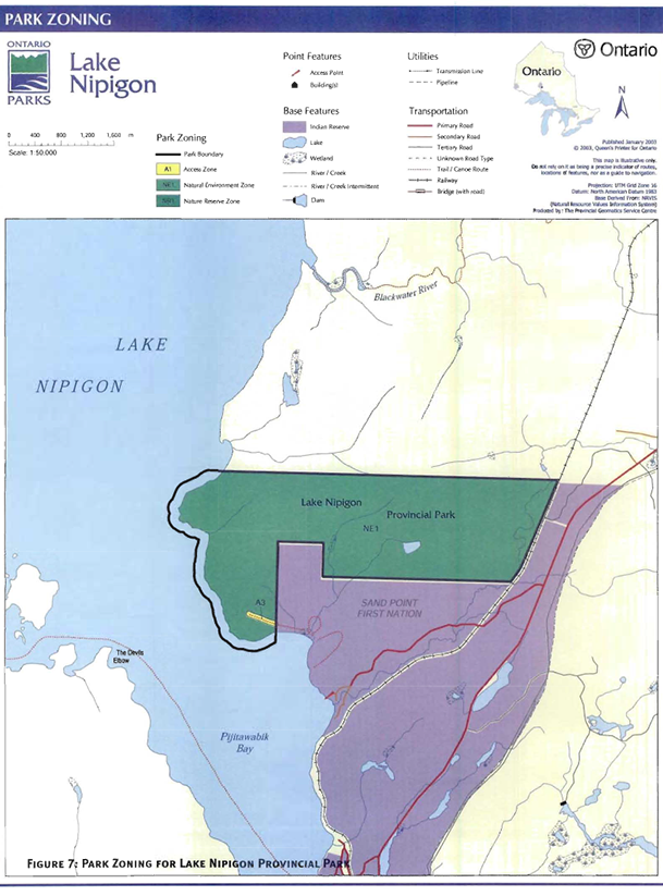
There are six zones that could guide the resource management and development of Lake Nipigon Provincial Park. These designations include natural environment, development, access, wilderness, historical and nature reserve zones (Table 1 and Figure 2).
For the nature reserves in this plan, three zones could guide the resource management and development, namely access, historical and nature reserve zones (Table 1 and Figures 2 through 6).
Any change in zoning after the park management plan is approved would require review through the management plan amendment process as outlined in the Ontario Provincial Park Management Planning Manual (MNR 1994).
7.1 Nature reserve zones
Nature reserve zones protect the provincially significant earth and/or life science features within a park and may include a protected buffer area in which a minimum of development is permitted. Development is generally restricted to trails, necessary signs, interpretive facilities (where warranted) and temporary facilities for research and management.
7.1.1 Nature reserve zone 1 (1,952 hectares) (Kabitotikwia River)
All of Kabitotikwia River Provincial Nature Reserve is zoned nature reserve to protect the wetland vegetation and shoreline nesting birds. This designation precludes motorized watercraft in the area. Anglers may paddle their boats through the park, then continue to use their motors once they are beyond the park boundary.
7.1.2 Nature reserve zone 2 (1,778 hectares) (Livingstone Point)
This zone is established to provide protection to the habitat used year-round by woodland caribou.
7.1.3 Nature reserve zone 3 (1,101 hectares) (West Bay)
The nature reserve zone provides protection of the Onaman Interlobate Moraine and glacial Lake Kelvin shoreline features.
7.1.4 Nature reserve zone 4 (8,395 hectares) (Windigo Bay)
The purpose of this nature reserve zone is to protect the woodland caribou wintering area, movement corridor, ancient beach ridges of glacial Lake Kelvin, dune complex and large fen in the park.
No new development, facilities or services will be permitted in the nature reserve zone, except for research facilities and infrastructure as outlined in section 9.3.
7.2 Access zones
Access zones serve as staging areas, a means of both providing and regulating use in areas of the park geared towards low-impact recreation, such as “leave-no-trace” camping in natural environment parks. Provision may be made for limited self-use orientation. Limited facilities for research and park management may be present. Two access zones have been designated in Windigo Bay Provincial Nature Reserve, and one access zone has been designated in Lake Nipigon Provincial Park.
7.2.1 Access zone 1 (34 hectares) (Windigo Bay Road)
This access zone is comprised of the 15-metre wide road corridor that provides members of the Whitesand First Nation with road access to within one kilometre of their healing lodge. Use of the road will comply with the Memorandum of Understanding signed in 1998 between Whitesand First Nation and MNR/Ontario Parks.
7.2.2 Access zone 2 (2 hectares) (Windigo Bay Trail)
This access zone links the terminus of the road through Windigo Bay Provincial Park to the healing lodge and allows Whitesand First Nation members to travel by ATV, snowmobile and by foot. This zone is limited to the width of the trail and extends from the terminus of the road to the park boundary to the south. Development in this zone will be restricted to trail maintenance and improvements needed to safely transport youth and elders between the road and the healing lodge.
The use restrictions articulated in 7.2.1 will also apply to this access zone.
Whitesand First Nation members accessing the healing lodge, commercial trappers accessing their traplines and employees of the Ministry of Natural Resources will be permitted to use mechanized travel within the park. Other uses of the road are discouraged.
7.2.3 Access zone 3 (1 hectare) (Thunderbird Lookout Trail)
This zone in Lake Nipigon Provincial Park is limited to the existing trail. The existing trail may be upgraded to a 15-metre wide trail, to allow for motorized carts and vehicles from the proposed Copper Thunderbird resort on Sand Point Indian Reserve to the Thunderbird Lookout that is located within the park. Such improvements would require a site plan.
7.3 Natural environment zones
Natural environment zones include natural landscapes, which permit the minimum level of development required to support low-intensity recreational activities. Development is limited to backcountry campsites, portages, necessary signs and minimal interpretive facilities.
7.3. 1 Natural environment zone 1 (918 hectares) (Lake Nipigon)
The balance of Lake Nipigon Provincial Park is zoned natural environment. This zone provides site protection for the representative landscape units in the park. It encompasses rugged, backcountry landscapes. This area may be utilized in the development of compatible high-quality, low intensity, non consumptive, recreational opportunities.
Development in this zone will be limited to backcountry campsites, hiking and cross-country ski trails, and route signs where required.
8.0 Resource stewardship policies
The management of the natural and cultural resources within Lake Nipigon Provincial Park will conform with the policies identified for natural environment parks in Ontario Provincial Parks: Planning and Management Guidelines (1992). The management of the natural and cultural resources within Kabitotikwia River, Livingstone Point, West Bay, and Windigo Bay Provincial Nature Reserves will conform with the policies identified for nature reserve parks in Ontario Provincial Parks: Planning and Management Guidelines (1992). Additional policy direction is provided in the following section.
First Nation members carry out traditional natural resource harvesting activities in accordance with their rights. Aboriginal and treaty rights are constitutionally protected.
8.1 Natural resources
8.1.1 Landform
The management of the parks’ land base will be directed towards maintaining the natural landscape. Mineral exploration and mining are prohibited within the boundaries of these parks. No new gravel pits are permitted in these parks. Aggregate for park purposes will be acquired from sources outside the park.
Peat extraction is not permitted within the boundaries of these parks.
8.1.2 Water
Water quality for fisheries habitat and recreational purposes will be maintained.
Water quality adjacent to access zones will be monitored where feasible, in accordance with Provincial standards.
Commercial hydro development is not permitted within the boundaries of Lake Nipigon Provincial Park, Kabitotikwia River, Livingstone Point, West Bay Provincial Park, and Windigo Bay Provincial Nature Reserves.
8.1.3 Vegetation
Generally, vegetation management within these five parks will be limited, allowing succession of communities to occur in an unmanipulated manner.
Active vegetation management activities (e.g. prescribed burns, thinning) may be used in limited cases to produce desired vegetation results (e.g. protection of woodland caribou habitat, ensuring future supply of woodland caribou habitat).
Commercial timber harvesting is prohibited within these parks.
Infestations of forest insects and diseases will be monitored and assessed, where feasible. Non-native species will be controlled, and native species may be controlled. If control measures are undertaken, they will be applied to minimize effects on the general park environment. Biological controls will be used wherever possible.
The removal of hazardous trees will be permitted in all zones where safety is a concern (e.g. trails and access points). Areas experiencing adverse impacts will be rehabilitated whenever possible using plant species native to the park.
Brushing and ditching along approved roads may be permitted to improve sight lines and/or traffic flow.
Herbicide applications will be discouraged for vegetation management.
Development that necessitates the removal of vegetation will be supported by a vegetation inventory in accordance with an approved site plan.
8.1.4 Fire
Fires within these five provincial parks will be managed to protect park visitors and prevent socio-economic disruption. The ecological role of fire as an agent of disturbance for the maintenance of ecosystems and critical habitat will be promoted. Fire management will promote a “naturalness” objective to approximate a natural forest and wildlife habitat condition. Fires will be managed to minimize the loss or damage to provincial park property, infrastructure and structures. Prescribed fires will be managed to minimize impacts on adjacent land users and communities through proper planning and sound decision-making. A fire management plan, in coordination with fire and vegetation research, will be developed for these parks to enable prescribed burning.
Light on the Land fire suppression techniques is the preferred option when protecting sensitive features. All fires that threaten park visitor safety or park infrastructure will receive Full Response and sustained action until extinguished. In the absence of an approved Fire Management Plan or Interim Fire Response Strategy for these parks, fires on the mainland will generally receive a Full Response and Sustained Action until extinguished. A Modified Response could occur after more detailed planning and in consultation with the park superintendent and the fire executive officer. The use of Suppression Action requires the approval of a Fire Assessment Report (FAR).
Fires that enhance caribou wintering habitat in Livingstone Point and Windigo Bay Provincial Nature Reserves will receive a Modified and/or Monitored Response, subject to more detailed planning and in consultation with the park superintendent. Prescribed burning may be used to meet ecosystem management Objectives in the nature reserve zones within the four nature reserve parks, including enhancing caribou wintering habitat in Livingstone Point and Windigo Bay Provincial Nature Reserves.
8.1.5 Wildlife
The management of wildlife, including species at risk, will be limited within these five parks. Generally, succession of wildlife communities will occur in an unmanipulated manner. In certain cases, passive management (i.e. non intervention) of species at risk and habitat will not guarantee the perpetuation of that species. If this is determined, then active management may be undertaken in the context of the broader management strategy for this species.
Hunting is prohibited in all five parks within this management plan. Status Indians having treaty rights to carry out traditional natural resource harvesting activities shall be permitted to carry on these activities in accordance with the terms of their treaty within their treaty area. These aboriginal and treaty rights are constitutionally protected.
Nuisance animals will be trapped and removed under the supervision of, or directly by Ministry of Natural Resources staff. This control will be exercised as a last resort when it is essential for the protection of human health and safety, the health of animal species, or the protection of infrastructure.
At present, there is a small portion of trapline NG-86 contained within Livingstone Point Provincial Nature Reserve. This trapline is currently held by a non-native trapper and, as such, will be phased out of the park by January 1, 2010. The trapline NG- 21 is held by a First Nation community, and entirely contains West Bay and Kabitotikwia River Provincial Nature Reserves. There are two traplines (NG-29 and NG-50) located within Windigo Bay that are held by Status Indians enjoying treaty rights. Trapline NG-108 is also held by a Status Indians enjoying treaty rights, and encompasses Lake Nipigon Provincial Park. There are no trapline cabins located within any of these park boundaries. Licensed commercial trapping will be allowed to continue in nature reserves only for Status Indians enjoying treaty rights. Otherwise it will be phased out by January 1, 2010 or prior to this date if the trap line is surrendered through normal processes. If a licence is revoked, surrendered, or an application for transfer is received prior to 1is date, all portion, of the registered trapline within the park will be rescinded from the traplines’ legal descriptions. Trapline cabins will not be permitted within the parks. New commercial trapping is prohibited within these five provincial parks. Snowmobiles will be the only form of off-road transportation permitted in the parks, and only for the purpose of trapping or by members of Whitesand First Nation to access their healing lodge via access Zones 1 and 2.
8.1.6 Fisheries
The Nipigon District Fisheries Management Plan identifies strategies for Lake Nipigon Provincial Park, as well as Kabitotikwia River, Livingstone Point, West Bay Provincial, and Windigo Bay Provincial Nature Reserves.
Management of the fisheries resource will strive to protect a healthy aquatic ecosystem, which is aimed at maintaining or enhancing a self-sufficient native-species fishery.
Sport fishing is permitted in the parks. All fishing activities will be subject to the policies and regulations of the Ontario Fishing Regulations. Kabitotikwia River, West Bay and Windigo Bay Provincial Nature Reserves are located within Division 21 of the Ontario fishing Regulations. Lake Nipigon Provincial Park and Livingstone Point Provincial Nature Reserve are included in Division 33 of the Ontario Fishing Regulations. The Park Superintendent may restrict sport fishing at certain times and locations for the purposes of fisheries management and/or public safety.
Stocking and spawn collection is not permitted.
The use and possession of baitfish is not permitted.
Existing commercial fishing on Lake Nipigon is permitted to continue within the boundary of Lake Nipigon Provincial Park and in the waters adjacent to the nature reserves.
Status Indians having treaty rights to carry out traditional natural resource harvesting activities shall be permitted to carry on these activities in accordance with the terms of their treaty within their treaty area. These aboriginal and treaty rights are constitutionally protected.
Existing park development
8.2 Cultural resources
All five of these provincial parks are within the boundaries of lands covered under the Robinson-Superior 1850 Treaty.
Windigo Bay Provincial Nature Reserve surrounds the site of “Old Whitesand”.
This site has historical, traditional and spiritual significance to Whitesand First Nation and is the location of the healing lodge site.
Biinjitiwaabik Zaaging Anishinaabek is located on the southeast shore of Lake Nipigon. Members of this community travel on the lake, actively hunting and fishing for subsistence, as well as engaging in commercial fishing.
Gull Bay First Nation is located on the west shore of Lake Nipigon, just north of Kabitotikwia River Provincial Nature Reserve. Members of the community rely on the lake for subsistence and have commercial fishing licences on Lake Nipigon.
Sand Point First Nation is currently negotiating their land base with the Government of Canada, but are exploring commercial and residential opportunities on the land between Lake Nipigon Provincial Park and Biinjitiwaabik Zaaging Anishinaabek. There are plans to develop the Copper Thunderbird resort on this site. This ecotourism and cultural awareness centre will provide employment and income to the reserve and its residents. A trail from the lodge to the Thunderbird Lookout is being proposed in Lake Nipigon Provincial Park.
Members of Lake Nipigon Ojibway are also currently negotiating with the Government of Canada to establish a land base for their reserve. The site being discussed for the reserve is located east of the Lake Nipigon Basin Signature Site. Members of the community currently use the lake and may develop economic opportunities nearby.
Red Rock First Nation is located on Lake Helen, immediately adjacent to the signature site.
Poplar Point Ojibway and Poplar Point are communities of people currently seeking First Nation status. They have interests in and around Lake Nipigon. Ontario Parks recognizes that all First Nations within the signature site have traditional interests in the park(s) close to their communities.
Ontario Parks will continue to work with First Nat ion groups to document and protect cultural resources in the park. There are no formal land claims regarding any of these five parks at this time.
The focus of cultural/heritage representation in Ontario Parks is the protection of significant landscape-related cultural resources. Cultural resources will be managed to ensure their protection, and to provide opportunities for heritage appreciation and research where these activities do not impair the resource.
This will be achieved through zoning and by controlling any recreational activities, development and research that may occur in these areas.
Although there is little documented evidence of known cultural occurrences, there is a high potential for cultural sites within Kabitotikwia River, and Livingstone Point Provincial Nature Reserves. Archaeological artifacts including Laurel pottery and Black Duck pottery shards have been found in Windigo Bay Provincial Nature Reserve. These artifacts correspond to known cultural sites. There is high potential for other occurrences within Windigo Bay Provincial Nature Reserve.
Ontario Parks/MNR will continue to work with the Ministry of Citizenship, Culture and Recreation in the inventory, protection and maintenance of archaeological and historic sites. If deemed appropriate for the protection and preservation of cultural resources, such inventory may include excavation of archaeological sites. Excavation by authorized licensed personnel with appropriate research permits will be conducted under the approval and supervision of the above Ministries. Upon completion of an excavation, the site or portions of the site will be returned to the extent possible to their original condition, or will be developed for the purpose of interpreting the cultural resources of the site. The type and extent of such development will be determined by the findings from the excavation.
In order to protect these sites, Ontario Parks/MNR does not disclose the locations of known cultural or archaeological sites.
Periodic inspection of significant sites will occur with protective controls established as required. The removal of artifacts or destruction of historical features is illegal and prohibited. Additional significant archaeological discoveries may necessitate alterations to future development plans and /or park zoning
9.0 Operational policies
lake Nipigon Provincial Park, as well as Kabitotikwia River, Livingstone Point, West Bay and Windigo Bay Provincial Nature Reserve are non-operating parks.
9.1 Natural heritage education
Because of the remote nature of these five parks and the relatively few number of people who visit the parks annually, the five parks in and around lake Nipigon offer a self-use level of programming.
Natural Heritage Education programming will be limited to information contained in brochure(s) and on the Ontario Parks website.
9.1.1 Park information
A public inform at ion program will be offered a part of the Ontario Parks website. It will provide visitors with information about the park and its resources, environment and facilities. This information will emphasize the visitors’ role in maintaining the natural environment of the park, appropriate behaviour in the park, and public safety.
Park literature will also advise visitor about commercial services and attractions in each local area and in other provincial parks.
Subject to available resources park maps will be prepared. The park maps and brochures enable visitors to safely explore and use the park. A “respect the environment” ethic will be promoted in order to minimize human impact on the park environment.
Park information may also be included in promotional material for the Lake Nipigon Basin Signature Site.
9.1.2 Interpretation
Interpretive programs and facilities provide park visitors with a greater understanding of the natural and cultural feature. Printed material and self-use facilities will be the primary means of interpretation. The parks’ ’primary interpretive themes relate to geology and how this geology has affected cultural activities. The areas represent several period themes such as Fur Trade; Indigenous Settlers, Traders and Potters; and Northern Hunters and Fishers, as well as the parks’ life and earth science features. Innovative ways of cooperative portrayal of these themes may be pursued with other agencies or partners.
9.1.3 Recreation
Basic recreation information provided on the park maps will acquaint visitors with the attributes of the park.
9.2 Recreation management
Recreation management provides a variety of recreational opportunities while aspiring to minimize negative environmental impacts in recognition of the parks’ significant landscape. Recreational activities that are incompatible with the park goal or with specific zones are prohibited or restricted. Prevention and control of such activities will be achieved through education and enforcement of park visitors concerning appropriate activities in the parks in general and within specific zones (Table 1). Low intensity recreation compatible with park values will be encouraged.
Camping in all five of these provincial parks is prohibited.
9.2.1 Kabitotikwia river
The park will be promoted as a paddling and sport fishing area where high potential exists for viewing waterfowl and wildlife. Motorboat use is prohibited.
9.2.2 Thunderbird lookout
Low intensity recreation will be confined to the trail within the park. The Thunderbird Lookout Trail may be upgraded to a road to allow visitors from the proposed Copper Thunderbird resort to use motorized access. Trail development must follow an approved site plan.
9.2.3 Greater park ecosystem
Within the context of the greater ecosystem, it is important to consider the ecological, social and economic relationships that these parks have with the surrounding area. Social and economic links include the local towns and First Nation communities whose residents and businesses either visit the parks and/or utilize the parks as an anchor or draw for recreation activities and business opportunities. The First Nation communities around Lake Nipigon use the entire area, including these parks, for spiritual, cultural, commercial and subsistence purposes.
9.3 Research
Ontario Park’s research and information needs relate directly to the Ministry of Natural Resources’ mandate and the provincial parks’ goal and objectives. Park-based research needs to address the wide range of environmental, social and economic factors necessary to administer an ecologically sustainable system of parks. It is also important that research activities address the demand for good quality outdoor recreation experiences and customer satisfaction.
Research information needs are diverse. They cover the full spectrum of geological, biological, ecological, cultural, recreational and social sciences.
Scientific research and monitoring by qualified groups and individuals which contributes to the knowledge, inventory and identification of natural and cultural features and to environmental and recreational management objectives will be encouraged where appropriate. Subjects of particular interest include archaeology, geomorphology and geology, as well as earth and life science studies.
All research programs must be compatible with the parks’ goal, objectives and zoning prescriptions. Research projects require prior approval and must be conducted in accordance with MNR policy concerning research in provincial parks. Research must also meet all other applicable provincial requirements. Park staff at the zone office will monitor these research programs. Any archaeological research will also require approval and monitoring by the Ministry of Culture. Should provincially or nationally significant features/resources be found, the management plan may be amended to ensure that protection will be provided through appropriate zoning or revision of plan policies.
Research will continue to monitor the effects of the access road through Windigo Bay Provincial Nature Reserve on park values, including caribou, plant populations and water quality for fish.
Research to determine the importance of the pelican nesting colony on islands adjacent to Windigo Bay Provincial Nature Reserve will be completed. This study will determine if the islands should be included in the park. Other research subjects of particular interest for Windigo Bay Provincial Nature Reserve would include woodland caribou populations, migration corridors, habitat suitability and the appropriateness of using fire as a vegetation Management tool.
Wildlife facilities and infrastructure may be permitted for scientific research if approved by the Park Superintendent.
10.0 Development policies
Development policies identify priorities for new development as well as redevelopment of existing facilities. Development is implemented through business and work program planning, based on priority and subject to the availability of human and financial resources, and in accordance with approved site and development plans that detail the location, type and extent of the development permitted.
Ontario Parks will:
- Work in conjunction with the Ministry of Culture to conduct archaeological site assessments in any area of the proposed development. Should sites be known or discovered to exist in an area, inventory of the site(s) will occur; and
- Undertake earth and life science inventories so that development impacts can be mitigated.
No development will take place in nature reserve zone except for necessary signs trails and facilities that mitigate human impacts.
10.1 Roads and trails
Maintenance of existing roads in access zones will be permitted. All other road - will be decommissioned or allowed to naturally abandon. No new roads will be permitted within these five parks, with the exception of the completion of the road through Windigo Bay Provincial Park (Zone 1 and 2). The existing Thunderbird Lookout trail (Lake Nipigon Provincial Park, Zone 3) maybe upgraded to a 15-metre-wide trail.
The construction of new trails as described in this plan will be subject to approved site plans.
11.0 Plan implementation and review
In the implementation of the approved park management plan, Ontario Parks may pursue opportunities for partnerships involving other agencies and groups. Park development, operations and resource stewardship will be contingent upon the availability of funding and unforeseeable change in priority or policy. Funding may be derived from a variety of source including corporate sponsorships and donations. Implementation of the management plan and operation of the park will meet the requirement of the Environmental Assessment Act, Provincial Parks Act and other pertinent legislation.
Unless otherwise identified in this document, implementation priorities may be established in subsidiary operating and resource stewardship plan. Preparation of these plan. will involve the appropriate level of public consultation.
A list of implementation priorities follows. The order may be varied without a plan amendment.
11.1 Resource stewardship
- Install signs along Kabitotikwia River Provincial Nature Reserve boundary prohibiting motorboats and baitfish·
- Monitor the effects of the access road through Windigo Bay on park values;
- Undertake detailed life science inventories of Kabitotikwia River, Livingstone Point and West Bay;
- Prepare vegetation and fire stewardship plan(s) for Lake Nipigon, Kabitotikwia River, Livingstone Point, West Bay and Windigo Bay.
- Monitor potential remote campsite locations for signs of use (i.e. West Bay); and
- Undertake detailed earth science inventories of Kabitotikwia River, West Bay and Windigo Bay;
- Undertake detailed cultural inventory of Kabitotikwia River, Livingstone Point, West Bay and Windigo Bay.
11.2 Development
- Prepare park maps, and
- Evaluate potential improvements to Thunderbird Lookout trail, and associated construction if necessary
11.3 Project screening
The Environmental Assessment Act requires that all park management activities conform to approved legislation, policy, procedures, guidelines and standards, including provision for public notice. The preparation of this park management plan constitutes the principal public review opportunity for activities and projects. Exceptions to this are projects where further study is required, or where a decision has been deferred to a subsidiary plan.
11.4 Plan review and amendment
The Lake Nipigon Basin Signature Site Park Management Parent Plan may be reviewed throughout its twenty-year life span, where warranted, to address issues or changing conditions.
A variety of monitoring programs will provide essential information concerning the effectiveness of approved policies. Such mechanisms as the collection of user statistics, periodic user surveys and park management audits will provide valuable information to ensure that policies remain current and relevant. Research findings and resource inventory work may aid in conducting plan reviews.
12.0 Public consultation
Public consultation for the Lake Nipigon Basin Signature Site began in January, 2001 with the Invitation to Participate (OMNR 2001). This was followed by a series of open houses to present the background information in June, 2001. A stakeholder meeting to discuss management options and ideas was held in September, 2001. Another series of open houses were conducted to present the Management options in December, 2001 and January, 2002. First Nations and a variety of stakeholders interest gr ups and individual members of the public have expressed an interest in the project including anglers and hunters, cottagers, commercial fishermen, forestry, mining and utility companies, and recreational, naturalist and environmental group. Discussions have also been held with the Nipigon Watershed Advisory Committee and with Nipigon West, Nipigon East, Spruce River and Armstrong Local Citizens Committees.
Input was received in the form of letters (20 +), open house comment beets (54). questionnaires (31) e-mails (10), briefs (3) proposals (1), data input and correction forms (9), as well as through numerous meetings and telephone calls. Approximately 240 people attended the June, 2001 Open House located in Nipigon Beardmore, Armstrong and Thunder Bay. Approximately 245 people attended the December, 2001 Open Houses located in Nipigon, Beardmore, Armstrong, Thunder Bay and Biinjitiwaabik Zaaging Anishinaabek. Approximately 207 people attended the September 2002 Open Houses located in Nipigon, Beardrnore, Armstrong and Thunder Bay.
The dominant themes in the comments are reflected in the content of this park management parent plan and include:
- Classification of Lake Nipigon Provincial Park;
- Motorized boats within Kabitotikwia River Provincial Nature Reserve; and
- Use restrictions on the road through Windigo Bay Provincial Nature Reserve.
This is the publics’ final opportunity to review the approved park management parent plan. For a period of 45 days, interested participants in the process have a final opportunity to determine if their concerns have been considered and addressed and to initiate an appeal concerning the plan contents where necessary.
Ontario Parks will retain on file reference copies of relevant background information, terms of reference, preliminary park management parent plan and the approved park management parent plan.
Appendix
Commercial activities
| Activity | Permitted? | Guidelines |
|---|---|---|
| Aggregate extraction | No | Please see Section 8.1.1 for more information |
| Bait fishing (commercial) – existing/new | No | Acitivity does not presently occur |
| Commercial fishing – existing | Yes | Acitivity does not occur within inland lakes in the park. The activity may occur as part of the commercial fishery on Lake Nipigon. Please see Section 8.1.6 for more information. |
| Commercial fishing – new | No | |
| Commercial fur harvest – existing | Yes | Existing use permitted to continue indefinitely. Please see Section 8.1.5 for more information |
| Commercial fur harvest – new | No | |
| Commercial hydro development | No | New commercial development is not permitted. Please see Section 8.1.2 for more information. |
| Commercial timber harvest | No | New commercial development is not permitted. Please see Section 8.1.3 for more information. |
| Commercial Tourism (e.g. outfitting services, outpost camps, resorts/lodges) – existing | No | Activity does not presently occur. New commercial tourism associated with Copper Thunderbird may be permitted. |
| Commercial Tourism (e.g. outfitting services, outpost camps, resorts/lodges) – new | Maybe | Proposals will be reviewed through future planning. |
| Energy transmission & communications corridors (new) | No | These facilities should avoid park lands wherever possible. |
| Mineral exploration and development | No | |
| Wild rice harvesting - existing/new | No |
Land and resource management activities
| Activity | Permitted? | Guidelines |
|---|---|---|
| Crown land disposition – private use | No | No land disposition for the private use of individuals is permitted. |
| Crown land disposition – commercial use | Yes | Commercial disposition subject to decisions regarding commercial tourism determined through future planning. |
| Fire suppression | Yes | Please see Section 8.1.4 for more information. |
| Fish habitat management | Yes | Please see Section 8.1.4 for more information. |
| Fish stocking – native and non-native species | No/No | Please see Section 8.1.6 for more information. |
| Insect/disease suppression | Yes | Please see Section 8.1.3 for more information. |
| Inventory/monitoring | Yes | |
| Personal use permits for wood harvesting | No | |
| Prescribed burning | Yes | Prescribed burning may be used to meet ecosystem management objectivies in the nature reserve zones. Please see Section 8.1.4 for more information. |
| Roads (non-park use) – existing and new | No/No | |
| Vegetation management | Yes | Please see Section 8.1.3 for more information. |
| Water control structure – existing and new | No/No | |
| Wildlife population management | Yes | Please see Section 8.1.5 for more information. |
Science, education & heritage appreciation
| Activity | Permitted? | Guidelines |
|---|---|---|
| Demonstration areas | No | |
| Historical appreciation – self guided | Yes | |
| Nature appreciation – self guided | Yes | |
| Photography and painting | Yes | |
| Research | Yes | Subject to authorization. |
| Wildlife viewing | Yes | Limited to facilities (e.g. duck blinds) to be used for research. |
Recreation activities and facilities
| Activity | Permitted? | Guidelines |
|---|---|---|
| Aircraft landing (water) | No | |
| ATV use – on trails and off trails | No/No | |
| Camping | No | |
| Horseback riding (trail) | No | |
| Hunting | Yes | Backcountry campsites only. Please see Section 7.2.1 for more information. |
| Mountain bike use | No | |
| Motor boat use – private and commercial | Yes | The use of motorized boats is prohibited on any inland waters within Lake Nipigon Provincial Park. Motorized boats are allowed on Lake Nipigon within the park boundary. |
| Non-motorized recreation travel (canoeing, kayaking, hiking, cross- country skiing, snowshoeing) | Yes | |
| Private recreation camps ("hunt camps”) - existing and new | No/No | |
| Rock climbing | No | |
| Sailing and sailboarding | Yes | Activity is permitted on Lake Nipigon only. Activity is prohibited on inland lakes. |
| Scuba and skin diving | Yes | Activity is permitted on Lake Nipigon only. Activity is prohibited on inland lakes. |
| Snowmobiling – on trails | Yes | Snowmobile use is restricted to trappers accessing existing trapline trails for trapline NG-108 |
| Snowmobiling – off trails | No | |
| Sport fishing | Yes | Consult the Ontario Recreational Fishing Regulations Summary for specific local details. |
| Trail development | No | Please see Section 10.1 and 7.2.1 for more information. |
Note: The policies outlined in this table do not supersede any Aboriginal or treaty rights that may exist, or other legal obligations.
Commercial activities
| Activity | Permitted? | Guidelines |
|---|---|---|
| Aggregate extraction | No |
Please see Section 8.1.1 for more information. |
| Bait fishing (commercial) – existing | Yes | Existing use to be phased out no later than Jan. 1, 2010. Please see Section 8.1.6 for more information. |
| Bait fishing (commercial) – new | No | |
| Commercial fishing – existing | No | |
| Commercial fishing – new | No | |
| Commercial fur harvest - existing | Yes | Please see Section 8.1.5 for more information. Existing use to be phased out no later than Jan. 1, 2001, except for trapping by Status Indians enjoying Treaty rights. |
| Commercial fur harvest - new | No | |
| Commercial hydro development | No | Please see Section 8.1.2 for more information. |
| Commercial timber harvest | Please see Section 8.1.3 for more information. | |
| Commercial Tourism (e.g. outfitting service, outpost camps, resorts/lodges) -existing/new | No/No | |
| Energy transmission & communications corridors (new) | No | These facilities should avoid park lands whenever possible. |
| Mineral exploration and development | No | |
| Wild rice harvesting - existing/new | No/No | Activity does not presently occur. |
Land and resource management activities
| Activity | Permitted? | Guidelines |
|---|---|---|
| Crown land disposition – private use | No | No land disposition for the private use of individuals is permitted. |
| Crown land disposition – commercial use | Yes | All existing tenure issued by the Crown for private use will be phased out no later than Jan. 1, 2010. |
| Fire suppression | Yes | Please see Section 8.1.4 for more information. |
| Fish habitat management | Yes | Please see Section 8.1.2 and 8.1.6 for more information. |
| Fish stocking – native and non-native species | No/No | Please see Section 8.1.6 for more information. |
| Insect/disease suppression | Yes | Please see Section 8.1.3 for more information. |
| Inventory/monitoring | Yes | |
| Personal use permits for wood harvesting | Yes | |
| Prescribed burning | Yes | Prescribed burning may be used to meet ecosystem management objectives in the nature reserve zones. Please see Section 8.1.4 for more information. |
| Roads (non-park use) - exsiting/new | No/No | |
| Vegetation management | Yes | Please see Section 8.1.3 for more information. |
| Water control structure - existing/new | No/No | |
| Wildlife population management | Yes | Please see Section 8.1.5 for more information. |
Science, education & heritage appreciation
| Activity | Permitted? | Guidelines |
|---|---|---|
| Demonstration areas | No | |
| Historical appreciation – self-guided | Yes | |
| Nature appreciation – self-guided | Yes | |
| Photography and painting | Yes | |
| Research | Yes | Subject to authorization |
| Wildlife viewing |
Recreation activities and facilities
| Activity | Permitted? | Guidelines |
|---|---|---|
| Aircraft landing (water) | No | |
| ATV use – on trails/off trails | No/No | |
| Camping | No | |
| Horseback riding (trail) | No | |
| Hunting | No | |
| Mountain bike use | No | |
| Motor boat use - private/commercial | No/No | |
| Non-motorized recreation travel (canoeing, kayaking, hiking, cross- country skiing, snowshoeing) | Yes | |
| Private recreation camps ("hunt camps”) - Existing/New | No | |
| Rock climbing | No | |
| Sailing and sailboarding | Yes | |
| Scuba and skin diving | Yes | |
| Snowmobiling – on trails | Yes | Snowmobile use is restricted to trappers accessing existing traplines for trapline NG-21 |
| Snowmobiling – off trails | No | |
| Sport fishing | Yes | Consult the Ontario Recreational fishing Regulations Summary for specific local details. |
| Trail development | Yes | Please see Section 10.1 for more information |
Note: The policies outlined in this table do not supersede any Aboriginal or treaty rights that may exist, or other legal obligations.
Commercial activities
| Activity | Permitted? | Guidelines |
|---|---|---|
| Aggregate extraction | No |
Please see Section 8.1.1 for more information. |
| Bait fishing (commercial) – existing | Yes | Existing use to be phased out no later than Jan. 1, 2010. Please see Section 8.1.6 for more information. |
| Bait fishing (commercial) – new | No | |
| Commercial fishing – existing | No | |
| Commercial fishing – new | No | |
| Commercial fur harvest - existing | Yes | Existing use to be phased out no later than Jan. 1, 2001, except for trapping by Status Indians enjoying Treaty rights. |
| Commercial fur harvest - new | No | Please see Section 8.1.5 for more information. |
| Commercial hydro development | No | |
| Commercial timber harvest | No | |
| Commercial Tourism (e.g. outfitting service, outpost camps, resorts/lodges) -existing/new | No/No | |
| Energy transmission & communications corridors (new) | No | These facilities should avoid park lands whenever possible. |
| Mineral exploration and development | No | |
| Wild rice harvesting - existing | Yes | |
| Wild rice harvesting - new | No |
Land and resource management activities
| Activity | Permitted? | Guidelines |
|---|---|---|
| Crown land disposition – private use | No | No land disposition for the private use of individuals is permitted. |
| Crown land disposition – commercial use | No | All existing tenure issued by the Crown for private use will be phased out no later than Jan. 1, 2010. |
| Fire suppression | Yes | Please see Section 8.1.4 for more information. |
| Fish habitat management | Yes | Please see Section 8.1.6 for more information. |
| Fish stocking – native and non-native species | No/No | |
| Insect/disease suppression | Yes | Please see Section 8.1.3 for more information. |
| Inventory/monitoring | Yes | |
| Personal use permits for wood harvesting | Yes | |
| Prescribed burning | Yes | Prescribed burning may be used to meet ecosystem management objectives in the nature reserve zones. Please see Section 8.1.4 for more information. |
| Roads (non-park use) - exsiting/new | No/No | |
| Vegetation management | Yes | Please see Section 8.1.3 for more information. |
| Water control structure - existing/new | No/No | Please see Section 8.1.2 for more information. |
| Wildlife population management | Yes | Please see Section 8.1.5 for more information. |
Science, education & heritage appreciation
| Activity | Permitted? | Guidelines |
|---|---|---|
| Demonstration areas | No | |
| Historical appreciation – self-guided | Yes | |
| Nature appreciation – self-guided | Yes | |
| Photography and painting | Yes | |
| Research | Yes | Subject to authorization |
| Wildlife viewing | Yes |
Recreation activities and facilities
| Activity | Permitted? | Guidelines |
|---|---|---|
| Aircraft landing (water) | No | |
| ATV use – on trails/off trails | No/No | |
| Camping | No | |
| Horseback riding (trail) | No | |
| Hunting | No | |
| Mountain bike use | No | |
| Motor boat use - private/commercial | No/No | |
| Non-motorized recreation travel (canoeing, kayaking, hiking, cross- country skiing, snowshoeing) | Yes | |
| Private recreation camps ("hunt camps”) - Existing/New | No | |
| Rock climbing | No | |
| Sailing and sailboarding | No | |
| Scuba and skin diving | Yes | |
| Snowmobiling – on trails | Yes | Snowmobile use is restricted to trappers accessing existing traplines for trapline NG-86 |
| Snowmobiling – off trails | No | |
| Sport fishing | Yes | Consult the Ontario Recreational fishing Regulations Summary for specific local details. |
| Trail development | Yes | Please see Section 10.1 for more information |
Note: The policies outlined in this table do not supersede any Aboriginal or treaty rights that may exist, or other legal obligations.
Commercial activities
| Activity | Permitted? | Guidelines |
|---|---|---|
| Aggregate extraction | No |
Please see Section 8.1.1 for more information. |
| Bait fishing (commercial) – existing/new | No/No | |
| Commercial fishing – existing/new | No/No | Please see Section 8.1.6 for more information. |
| Commercial fur harvest - existing | Yes | Existing use to be phased out no later than Jan. 1, 2010. |
| Commercial fur harvest - new | No | Please see Section 8.1.5 for more information. |
| Commercial hydro development | No | |
| Commercial timber harvest | No | |
| Commercial Tourism (e.g. outfitting service, outpost camps, resorts/lodges) -existing/new | No/No | |
| Energy transmission & communications corridors (new) | No | These facilities should avoid park lands whenever possible. |
| Mineral exploration and development | No | |
| Wild rice harvesting - existing | Yes | Existing use to be phased out no later than Jan. 1, 2010, except for trapping by Status Indians enjoying Treaty rights. |
| Wild rice harvesting - new | No |
Land and resource management activities
| Activity | Permitted? | Guidelines |
|---|---|---|
| Crown land disposition – private use | No | No land disposition for the private use of individuals is permitted. |
| Crown land disposition – commercial use | No | All existing tenure issued by the Crown for private use will be phased out no later than Jan. 1, 2010. |
| Fire suppression | Yes | Please see Section 8.1.4. |
| Fish habitat management | Yes | Please see Section 8.1.6 for more information. |
| Fish stocking – native and non-native species | No/No | |
| Insect/disease suppression | Yes | Please see Section 8.1.3 for more information. |
| Inventory/monitoring | Yes | |
| Personal use permits for wood harvesting | Yes | |
| Prescribed burning | Yes | Prescribed burning may be used to meet ecosystem management objectives in the nature reserve zones. Please see Section 8.1.4 for more information. |
| Roads (non-park use) - exsiting/new | No/No | |
| Vegetation management | Yes | Please see Section 8.1.3 for more information. |
| Water control structure - existing/new | No/No | Please see Section 8.1.2 for more information. |
| Wildlife population management | Yes | Please see Section 8.1.5 for more information. |
Science, education & heritage appreciation
| Activity | Permitted? | Guidelines |
|---|---|---|
| Demonstration areas | No | |
| Historical appreciation – self-guided | Yes | |
| Nature appreciation – self-guided | Yes | |
| Photography and painting | Yes | |
| Research | Yes | Subject to authorization |
| Wildlife viewing | Yes |
Recreation activities and facilities
| Activity | Permitted? | Guidelines |
|---|---|---|
| Aircraft landing (water) | No | |
| ATV use – on trails/off trails | No/No | |
| Camping | No | |
| Horseback riding (trail) | No | |
| Hunting | No | |
| Mountain bike use | No | |
| Motor boat use - private/commercial | No/No | |
| Non-motorized recreation travel (canoeing, kayaking, hiking, cross- country skiing, snowshoeing) | Yes | |
| Private recreation camps ("hunt camps”) - Existing/New | No | |
| Rock climbing | No | |
| Sailing and sailboarding | No | |
| Scuba and skin diving | Yes | |
| Snowmobiling – on trails | Yes | Snowmobile use is restricted to trappers accessing existing traplines for trapline NG-27 |
| Snowmobiling – off trails | No | |
| Sport fishing | Yes | Consult the Ontario Recreational fishing Regulations Summary for specific local details. |
| Trail development | Yes | Please see Section 10.1. |
Note: The policies outlined in this table do not supersede any Aboriginal or treaty rights that may exist, or other legal obligations.
Commercial activities
| Activity | Permitted? | Guidelines |
|---|---|---|
| Aggregate extraction | No |
Please see Section 8.1.1. |
| Bait fishing (commercial) – existing | Yes | Existing use to be phased out no later than Jan. 1, 2010. |
| Bait fishing (commercial) – new | No | |
| Commercial fishing – existing/new | No/No | |
| Commercial fur harvest - existing | Yes | Existing use to be phased out no later than Jan. 1, 2001, except for trapping by Status Indians enjoying Treaty rights. |
| Commercial fur harvest - new | No | |
| Commercial hydro development | No | |
| Commercial timber harvest | No | |
| Commercial Tourism (e.g. outfitting service, outpost camps, resorts/lodges) -existing/new | No/No | |
| Energy transmission & communications corridors (new) | No | These facilities should avoid park lands whenever possible. |
| Mineral exploration and development | No | |
| Wild rice harvesting - existing/new | No/No |
Land and resource management activities
| Activity | Permitted? | Guidelines |
|---|---|---|
| Crown land disposition – private use/commercial use | No/No | Land disposition for the private use of individuals is not permitted. |
| Fire suppression | Yes | Please see Section 8.1.4. |
| Fish habitat management | Yes | Please see Section 8.1.6. |
| Fish stocking – native and non-native species | No/No | Please see Section 8.1.6. |
| Insect/disease suppression | Yes | Non-native species will be controlled and native species may be see Section 8.1.3 for more information. |
| Inventory/monitoring | Yes | |
| Personal use permits for wood harvesting | No | |
| Prescribed burning | Yes | Prescribed burning may be used to meet ecosystem management objectives in the nature reserve zones, including enhancing caribou wintering habitat. |
| Roads (non-park use) - exsiting | Yes | The existing road to access the healing lodge is permitted, subject to the terms and condititions outlined in section 7.2.1 and 7.2.2. |
| Roads (non-park use) - new | No | No new roads may be constructed in the park. |
| Vegetation management | Yes | Please see Section 8.1.3 for more information |
| Water control structure - existing/new | No/No | |
| Wildlife population management | Yes |
Science, education & heritage appreciation
| Activity | Permitted? | Guidelines |
|---|---|---|
| Demonstration areas | No | |
| Historical appreciation – self-guided | Yes | |
| Nature appreciation – self-guided | Yes | |
| Photography and painting | Yes | |
| Research | Yes | Subject to authorization. |
| Wildlife viewing | Yes |
Recreation activities and facilities
| Activity | Permitted? | Guidelines |
|---|---|---|
| Aircraft landing (water) | No | |
| ATV use – on trails | Yes | All terrain vehicle use for trapline management purposes and for Whitesand First Nation members accessing the healing lodge on the authorized road and trail, subject to management prescriptions outlined in Section 7.2.1 and 7.2.2. |
| ATV use – on trails/off trails | No | |
| Camping | No | |
| Horseback riding (trail) | No | |
| Hunting | No | |
| Mountain bike use | No | |
| Motor boat use - private | Yes | |
| Motor boat use - commercial | No | |
| Non-motorized recreation travel (canoeing, kayaking, hiking, cross- country skiing, snowshoeing) | Yes | |
| Private recreation camps ("hunt camps”) - Existing/New | No | |
| Rock climbing | No | |
| Sailing and sailboarding | No | |
| Scuba and skin diving | No | |
| Snowmobiling – on trails | Yes | Snowmobile use for trapline management purposes and for Whitesand First Nation members accessing the healing lodge on the authorized road and trail, subject to management prescriptions outlined in Section 7.2.1 and 7.2.2. |
| Snowmobiling – off trails | No | |
| Sport fishing | Yes | Consult the Ontario Recreational fishing Regulations Summary for specific local details. |
| Trail development | Yes | Please see Section 10.1. |
Note: The policies outlined in this table do not supersede any Aboriginal or treaty rights that may exist, or other legal obligations.
13.0 References
Bakowsky, WD. Winter 2002. NHIC Newsletter. Community Ecology Rare Vegetation of Ontario: Diabase Cliffs of Northwestern Ontario.
Bowater Inc. 2001. Black Sturgeon Forest Management Plan 2001-2021.
Coates, M.E. 1972. Geology of the Black Sturgeon River Area, District of Thunder Bay. Geological Report 98, Ontario Department of Mines and Northern Affairs.
Crins, WJ. 2000. Ecozones, Ecoregions and Ecodistricts of Ontario. Prepared for Ecological Land Classification Working Group. OMNR, Ontario Parks, Peterborough.
Greenmantle Forest Inc. 2001. Lakehead Forest Management Plan 2002-2022. Hills, G.A. 1964 map update. Site Regions and Districts of Ontario.
Harris, A., and Foster, R. 1997. A Biological Inventory and Evaluation of Windigo Bay Provincial Park.
Kor, P. 1978a. A Brief Geological and Geomorphology of Lake Nipigon Provincial Park. Ontario Ministry of Natural Resources. Unpublished report.
Kor, P. 1978b. Earth science inventory checklist: Windigo Bay. Ontario Ministry of Natural Resources. Unpublished report.
Nipigon District Staff. No date. Impact assessment sheet: Kabitotikwia River.
Nipigon District Staff. No date. Impact assessment sheet: Windigo Bay.
Noble, T. 1978a. Life science checksheet: Kabitotikwia River.
Noble, T. 1978b. Life science checksheet: Windigo Bay.
Ontario Geological Survey. 1981. NOEGTS 42- Frazer Lake Area.
Ontario Geological Survey. 1981. NOEGTS 58- Black Bay Area.
Ontario Native Affairs Secretariat & Ministry of Citizenship. 1992. Akwesasne to Wunnumin Lake: Profiles of Aboriginal Communities in Ontario.
Ontario Ministry of Natural Resources. 1983. Nipigon District Land Use Guidelines (DLUG).
Ontario Ministry of Natural Resources. 1989. Nipigon District Fisheries Management Plan.
Ontario Ministry of Natural Resources. 1992 update. Ontario Provincial Parks: Planning and Management Policies.
Ontario Ministry of Natural Resources. 1994. Lake Nipigon Provincial Park Management Plan.
Ontario Ministry of Natural Resources. 1996. Ontario Parks Barrier-free Guidelines Design Manual, Volume 3.
Ontario Ministry of Natural Resources. 1998. Boreal West Round Table Draft Recommendations.
Ontario Ministry of Natural Resources. 1999a. Ontario’s Living Legacy Land Use Strategy.
Ontario Ministry of Natural Resources. 1999b. Windigo Bay Provincial Park Interim Management Statement.
Ontario Ministry of Natural Resources. 2000. NRVIS- Nipigon District.
Ontario Ministry of Natural Resources. 2000. NRVIS- Thunder Bay District.
Ontario Ministry of Natural Resources. 2000. Draft Recreation Checklist- Nipigon District Staff.
Ontario Ministry of Natural Resources. 2001. Lake Nipigon Basin Background Document.
Ontario Ministry of Natural Resources. Winter 2002. Ontario Natural Heritage Information Centre Newsletter.
Ontario Ministry of Northern Development and Mines. 1991. Geology of Ontario; Special Volume 4 Part 1.
Ontario Ministry of Tourism, Culture and Recreation. 2001. Pers. Comm. (Jan. 4/0l)/ Archeological Files Regional Archeologist (Bill Ross).
Rowe, J.S. 1972. Forest Regions of Canada. Canadian Forestry Service Publication No. 1300.
Zoltai, S.C. 1965. Glacial Features of the Quetico-Nipigon Area, Ontario. Canadian Journal of Earth Sciences, 2(4): 247-269.
Zoltai, S.C. 1967. Glacial Features of the North-Central Lake Superior Region, Ontario. Canadian Journal of Earth Sciences, 4(3): 515-528.