Larder River Provincial Park Management Plan: Amendment
This document provides amended policy direction for the protection, development and management of Larder River Provincial Park and its resources.
Approval statement
I am pleased to approve this minor amendment to the Larder River Provincial Park Management Plan (OMNR 1998). This minor amendment is a statement of policy update to the original1992 management plan.
This minor amendment is based on the direction in Ontario’s Living Legacy Land Use Strategy (OMNR 1999) to add the Larder River Waterway Park Addition to Larder River Provincial Park. The original park management plan and this minor amendment address policies for protection, management and development of all lands and waters that are now regulated as part of Larder River Provincial Park in May 2002 (O. Reg. 147/02). In combination, the existing park management plan and this minor amendment provide guidance for the resource stewardship, management and development of all lands and waters within the new regulated park boundary under the Provincial Parks Act.
Signed by:
Paul Bewick
Manager
Northeast Zone
Ontario Parks
Date: February 12, 2007
1.0 Introduction
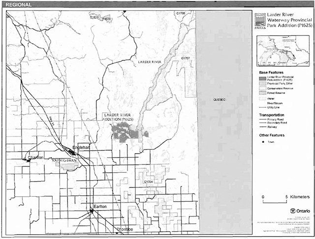
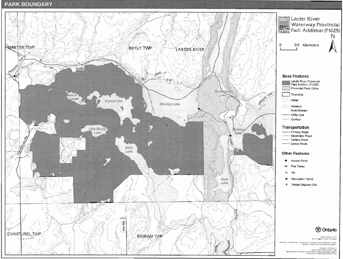
Larder River Waterway Park Addition is located approximately 28 kilometres to the north-east of Englehart, near the Quebec border (Figure 1). This park addition adds 1,535 hectares to the existing 2,509-hectare Larder River Provincial Park (Figure 2).
Larder River Waterway Park Addition was regulated as part of Larder River Provincial Park in May 2002 (O. Reg. 147/02). The park addition was identified through Ontario’s Living Legacy Land Use Strategy (OMNR 1999) and was designated as waterway class. The purpose of the waterway classification is to protect outstanding recreational water routes and to provide high quality recreational and educational opportunities.
1.1 Objectives
Larder River Waterway Park Addition will be managed consistent with the four objectives for provincial parks:
Protection: To protect provincially significant elements of the natural and cultural landscapes of Ontario.
Recreation: To provide provincial park outdoor recreation opportunities ranging from highintensity day-use to low-intensity wilderness experiences.
Heritage appreciation: To provide opportunities for exploration and appreciation of the outdoor natural and cultural heritage of Ontario.
Tourism: To provide Ontario’s residents and out-of-province visitors with opportunities to discover and experience the distinctive regions of the Province.
2.0 Management context
The purpose of this minor is to provide direction to ensure the custodial management of park resources. Future park planning may be undertaken as required to provide direction on significant decisions regarding resource stewardship, development, operations and permitted uses.
Park management will follow direction from:
- Provincial Parks Act (1990) and regulations
- Ontario Provincial Parks Planning and Management Policies (OMNR 1992)
- Ontario’s Living Legacy Land Use Strategy and policy clarifications (OMNR 2000), amendments, and related direction
- Crown Land Use Policy Atlas (OMNR 2004a)
In addressing custodial management obligations to protect park values and ensure public health and safety, Ontario Parks will ensure that policy and Environmental Assessment Act (1990) requirements are implemented.
2.1 Environmental Assessment
As a part of the Ontario Ministry of Natural Resources (MNR), Ontario Parks is a public sector agency which is subject to the Environmental Assessment Act. Park management will be carried out in accordance with legislation, policies, and guidelines that are required under A Class Environmental Assessment for Provincial Parks and Conservation Reserves (OMNR 2005a).
Figure 1: Regional Context
Enlarge Figure 1: Regional Context
Figure 2: Park Boundary

Enlarge Figure 2: Park Boundary
3.0 Park features and values
Larder River Waterway Park Addition boundary follows the Wendigo Lake shoreline in the north, contour lines and a creek in the west, Skeleton Lake in the east, and agricultural boundaries in the south (Harper 2002). The park addition contains several small lakes, including Beaver Lake, Crystal Lake, Little Moose Lake and Miller Lake. The site contains weakly broken bedrock with aspen, Jack pine, spruces, brush and alder, white birch, and open wetland (OMNR 1999).
3.1 Geological features
Larder River Waterway Park Addition is within the Cobalt Embayment of the Paleoproterozoic 2.4 to 2.2 billion years old (Ga) Huronian Supergroup of the Southern Province of the Precambrian Shield. Argillite, siltstone, sandstone, and conglomerate of the Cobalt Group Gowganda Formation outcrop are distributed extensively throughout the park. The subhorizontal Gowganda Formation is intruded by a Paleoproterozoic diabase sill of the 2.22 Ga Nipissing dike swarm and sheet intrusions, and one late Proterozoic dike of the circa 1.14 Ga Abitibi swarm. The representation of these geological environments in Larder River Waterway Park Addition contributes to the conservation of the Early Aphebian Huronian Stable Platform Precambrian environment theme (Frey and Duba 2002).
The bedrock geology of Larder River Waterway Park Addition is considered to be regionally significant for its extensive representation of components of the Gowganda Formation. The park addition is also regionally to provincially significant for its representation of a Nipissing diabase sill. In addition, the Abitibidiabase dike may be unique to provincial park system and may therefore be provincially significant (Frey and Duba 2002).
3.2 Biological features
The area is within the Atlantic and Englehart River watersheds. Larder River Waterway Park Addition contains weakly-broken bedrock covered with aspen, Jack pine, spruce, white birch, brush and alder, and treed wetlands. The park addition also contains open wetlands on lacustrine deposit. Bedrock areas are characteristically covered with larch, aspen, brush and alder, and white birch (Aikins 2003).
The park addition provides important habitat for moose (feeding and calving), raptors (nesting), Great Blue Heron, and cold and coolwater fish (Aikins 2003). Fish species inhabiting the park addition include Northern Pike, Yellow Perch, Rock Bass, Pumpkinseed, Brook Trout, Spottail Shiner, White Sucker, and Golden Shiner (Aikins 2003).
3.3 Cultural setting
There are currently no reports describing the cultural resources of Larder River Waterway Park Addition. Any future planning will be within the context of a provincial framework, A Topical Organization of Ontario History (OMNR 1974). In addition, updates and discussions with First Nations and other agencies and stakeholders may be carried out to identify cultural heritage values and features within the park and their significance. This information may be used to develop management guidelines to conserve and protect representative archaeological and historical values and features, or to provide direction for further research.
3.4 Recreation
The main recreational features in Larder River Waterway Park Addition are sport fishing, canoeing, hunting, and hiking. The park addition is used by local people and cottage owners. While there are no canoe routes in the park, there are two nearby routes: the Wendigo Lake Canoe Route and the Larder River Canoe Route, which is within the existing Larder River Provincial Park. The park addition would be suitable for developing semi-remote camping opportunities and hiking trails. Unauthorized ATV use likely occurs within the park on existing tertiary access roads and trails (Harper 2002).
4.0 Aboriginal uses
Larder River Waterway Park Addition lies within the Robinson Huron Treaty of 1850.
First Nations have expressed interest in and have shared knowledge of the park and surrounding area. Aboriginal communities have used the area for hunting, trapping, fishing, gathering and travel. These uses may continue, subject to public safety, conservation and other considerations.
Any communications and cooperation between Aboriginal communities and the MNR for planning and operations purposes will be done without prejudice to any future discussions or negotiations between the government of Ontario and Aboriginal communities.
5.0 Stewardship policies
The removal, damage or defacing of Crown properties, natural objects, relics, and artefacts is not permitted in provincial parks (Provincial Parks Act).
Non-native species will not be deliberately introduced into the park. Where non-native species are already established and threaten park values (i.e., has become invasive), a strategy to control the species may be developed (OMNR 1992).
5.1 Terrestrial ecosystems
5.1.1 Harvesting
Commercial forest operations are not permitted within the park. The harvest of non-timber forest products such as club moss, Canada yew, etc., will not be permitted (OMNR 1992).
Existing authorized wild rice harvesting may continue. New operations will not be permitted.
There are no fuelwood cutting permits issued for the park. New permits will not be issued (OMNR 2000).
5.1.2 Insects and disease
Insects and diseases may be managed where the aesthetic, cultural, or natural values of the park are threatened. Control measures will follow guidelines established by the Ontario Ministry of the Environment (MOE) and MNR. Whenever possible, biological control measures will be given preference over the use of chemicals (OMNR 1992).
5.1.3 Fire
Larder River Waterway Park Addition is located within the Boreal Fire Management Zone. In accordance with existing provincial park policy and the Forest Fire Management Strategy for Ontario, forest fire protection will be carried out in the park as on surrounding lands (OMNR 2004b). Whenever feasible, MNR's Forest Fire Management program will use techniques that minimize damage to the landscape, such as limiting the use of heavy equipment or limiting the number of trees felled during response efforts (OMNR 2004b).
5.1.4 Wildlife management
Larder River Waterway Park Addition is located within Wildlife Management Unit (WMU) 28. The removal or harassment of non-game animals is not permitted (Provincial Parks Act).
Hunting
Sport hunting is permitted to continue in Larder River Waterway Park Addition. Considerations of safety and conservation with respect to hunting may be made through future management planning, which would include public and Aboriginal consultation (OMNR 2000). Sport hunting is permitted in the natural environment zones of Larder River Provincial Park (OMNR 1998).
The Fish and Wildlife Conservation Act (1997) and the Migratory Birds Convention Act (1994) govern hunting within the park and park addition. The Ontario Hunting Regulations Summary contains regulations specific to this area. The harvest of bullfrogs or snapping turtles is illegal in provincial parks.
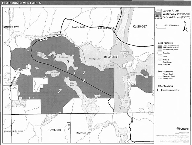
Bear management areas
Larder River Waterway Park Addition includes a portion of one bear management areas (BMA): KL-28-038 (Figure 3). This BMA is currently allocated. Existing commercial bear hunting operations are permitted to continue. This activity may be subject to conditions identified during future management planning (e.g., the designation of nature reserve zones). New BMA licences will not be permitted (OMNR 2000; 2003).
Trapping
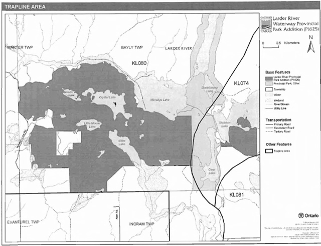
Larder River Waterway Park Addition includes portions of two trapline areas: KL080 and KL074 (Figure 4). Existing commercial fur harvesting operations may continue where the activity has been licensed or permitted since January 1, 1992. New operations, including trap cabins and trails, will not be permitted (OMNR 2000; 2003). Transfers of active trap line licenses are permitted, subject to a review of potential impacts and the normal transfer or renewal conditions that apply.
5.1.5 Adjacent Land
Forestry
The land adjacent to the park is within the Timiskaming Forest Management Unit (MU) #280. The management plan for this MU will be reviewed in 2010 (OMNR 2006).
Provincial parks
Kap-Kig-Iwan Provincial Park is located approximately 33 kilometres from Larder River Waterway Park Addition. Kap-Kig-Iwan was originally regulated as a provincial park in ; the park additions were regulated in October of 2001(O. Reg. 383/01). The main feature of this 461-hectare park is the Englehart River, which includes whitewater rapids, ragged outcrops, deep ravines, and a waterfall (OMNR 2004a).
Conservation reserves
Four conservation reserves (CR) are located near Larder River Waterway Park Addition: South Grassy Lake Outwash CR, McGarry Township Forest CR, East Larder River CR, and Hilliardton Marsh CR.
Figure 3: Bear management areas
Figure 4: Trapline areas
South Grassy Lake Outwash Conservation Reserve (C1626): The primary features of this site are young spruce on moderately broken outwash deposits and moderately broken bedrock (OMNR 2004a).
McGarry Township Forest Conservation Reserve (C1705): This CR contains moderately broken bedrock with dense coniferous forests, mixed coniferous forests, mixed deciduous forests, and sparse forest (OMNR 2004a).
East Larder River Bedrock Conifer Conservation Reserve (C1707): This CR also contains moderately broken bedrock with dense coniferous forests, mixed coniferous forests, mixed deciduous forests, and sparse forest (OMNR 2004a).
Hilliardton Marsh Conservation Reserve (C1704): Representative features within this CR include: lacustrine deposit with mixed deciduous forest, mixed conifer forest, and sparse forest. The CR also protects wetlands, which provide excellent habitat for waterfowl (OMNR 2004a).
General use areas
Three general use areas abut Larder River Waterway Park Addition: Little Clay Belt General Use Area, Wendigo-Skeleton Lakes General Use Area, and Lower Misema River-Little Skeleton Creek General Use Area.
Little Clay Belt General Use Area (G1841): This general use area contains 11 municipalities and is made up of mostly patented land. The major land use is agriculture, but there are commercial tourism operations, designated canoe routes, and industry in this area. The main land use intent for the area is to provide for agricultural production and related activities. Forestry, mineral aggregate extraction, mining, and industrial and urban development are also acceptable uses. Land use problems in this area are the use of agricultural lands for non-agricultural purposes and potential flooding and erosion along the waterwasy (OMNR 2004a).
Wendigo-Skeleton Lakes General Use Area (G1845): This general use area surrounds most of the park. The site, which is located on edge of the Little Clay Belt, is not municipally organized. Containing around 100 cottages and a designated canoe route, the major land use activity in this area is recreation. As such, the land use intent for the area is to provide cottaging and public recreation opportunities, with resource extraction being permitted away from shoreline areas (OMNR 2004a).
Lower Misema River-Little Skeleton Creek General Use Area (G1858): The majority of this general use area is Crown land. The main land use of the area is resource extraction; forestry is a major activity. The site contains a wetland, two earth science sites, and two Lake Trout lakes.
The land use intent for this area is to provide an adequate land base for resource extraction activities. Recreation is a secondary use and urban development is also permitted (OMNR 2004a).
Forest reserves
Forest reserves (FR) are areas where protection of natural heritage and special landscapes is a priority, but some resource use can take place with appropriate conditions. Policies for FRs are similar to the policies for new conservation reserves, except that mining and related activities will be allowed in a forest reserve. Commercial forest harvest, new hydroelectric power development, and peat extraction will not be allowed, but most other resource and recreation uses will be permitted, provided they are consistent with the features and values being protected (OMNR 1999).
The South Lake Grassy Outwash FR (F1626), which abuts the South Lake Grassy Outwash CR, is a designated FR, which consists of bothaive and inactive mining claims/leases. The strategy for FRs (OMNR 2005b) indicates that this FR will be redesignated as a General Use Area or an Enhanced Management Area (as appropriate).
5.1.6 Industrial uses
There is an existing aggregate permit (#10007) for a Category 10 pit within Larder River Waterway Provincial Park.
Aggregate extraction is not permitted in provincial parks unless it is allowed by regulation (OMNR 1992; Provincial Parks Act). Aggregate pits which are authorized under the Aggregate Resources Act to operate on the day section 18 of the new Provincial Parks and Conservation Reserves Act (2006) is proclaimed in force may continue in accordance with existing licences, permits or other authorizations. Otherwise aggregate extraction will not be permitted. As authorized and licenced aggregate pits are worked, there will be progressive or sequential restoration of the limits to allow sites to return to a natural condition (e.g., slope stabilization, native species plantings).
5.1.7 Land Disposition
New land disposition for the private use of individuals or corporations will not be permitted (OMNR 1992; 2000).
Land use permits. Licenses of occupation, and unauthorized occupations
One recreation camp land use permit (LUP) is located along the northern boundary of the park addition.
Existing authorized LUPs may be eligible for enhanced tenure but not the purchase of land. Recreational camp LUPs cannot be changed to commercial LUPs unless this is supported during a review as part of park management planning. Enhanced tenure is defined as a possible extension of the term of the LUP for up to 10 years or upgrade in tenure (i.e. LUP to lease) (OMNR 2000a).
Enhanced tenure for an LUP is not guaranteed. Requests for enhanced tenure or to transfer LUPs will be reviewed based upon the following criteria:
- Continued compliance with the conditions of the LUPs
- Current land disposition policies for LUPs
- Consistency with park objectives to sustain values - no effects on heritage values and/or conflict with other uses
- Consistency with Aboriginal land claim negotiations or protocol agreements
- All rents, taxes, fees, rates, or charges are paid and in good standing
An extension in the term of tenure for an existing LUP does not convey a commitment to provide for a change in the type or the standard of existing access to the private recreation camp.
There are no licenses of occupation and no known unauthorized occupations in Larder River Waterway Park Addition.
Patent land
Larder River Waterway Park Addition is mostly surrounded by Crown land, with private land abutting the park addition on the south-east side. There is also patent land on the shores of Wendigo and Skeleton lakes, and a large parcel of patent land within the park addition itself.
Private land is not included within the park addition boundary and, as such, park policy does not apply to these areas.
Boat caches
There are an undetermined number of unauthorized boat caches within Larder River Waterway Park Addition. Boats are not permitted to be left unattended in the park without written permission from the superintendent under the authority of the Provincial Parks Act.
Waste disposal site
There is a waste disposal site located near the eastern park addition boundary within Bayly Township. There is also another nearby parcel of land which was originally proposed for the waste disposal site.
5.1.8 Access and crossings
Access
Larder River Waterway Park Addition is accessible by land, water, and air.
There are several roads which provide access to the park addition. Wendigo Lake Road defines part of the western boundary of the park addition, and a secondary road leading to patented land defines part of the northern boundary. A secondary road branching from Wendigo Lake Road provides access to the section of patent land within the park addition. A few tertiary roads also enter the park addition on the southern and western sides.
The Larder River Canoe Route splits at Wendigo and Skeletonpup lakes; the western branch provides access to the western section of the park addition, and the eastern branch provides access to the eastern section. The park addition can be accessed by various points along Windigo and Skeleton lakes.
Some lakes in the park addition may be accessible by floatplane (e.g. Crystal and Miller lakes).
Roads
Secondary roads branching from Wendigo Lake Road and Highway 569 can be used to access certain areas of the park addition. These roads are used, primarily, to access patent land holdings which abut the addition. Tertiary roads and trails running through the addition are used to access lakes within the addition (Harper 2002).
Where existing forest and/or tertiary access roads are essential for continued access beyond the park for forest management, access to in-holdings (e.g. LUPs) or recreational purposes, and alternative road access does not exist, or road relocation is not feasible, existing roads will continue to be available for access. Continued use will include maintenance and may include upgrades (OMNR 2004a). Ontario Parks is not responsible for the maintenance or upgrade of any roads within the park boundary.
Any proposed development, maintenance or upgrading of existing roads must meet all Environmental Assessment Act requirements.
Utility corridors
There are no utility corridors within the Larder River Waterway Park Addition.
All public utilities (e.g., gas pipelines, transmission lines, communications towers) must avoid park lands wherever possible. New utility corridor crossings may be necessary to maintain essential public services (OMNR 2004a).
Any future utility corridors proposed through the park, where park lands are unavoidable, will be reviewed on a case-by-case basis. Protection of park features and values will be a priority and all requirements of the Environmental Assessment Act will be met.
Recreational trails
There are no authorized trails within Larder River Waterway Park Addition. New trails (e.g., hiking) may be developed if the need arises (OMNR 2004a). Any proposed development within the park is subject to Environmental Assessment Act requirements.
Unauthorized snowmobile and all-terrain vehicle (ATV) use may occur in this area. Existing use of roads and trails to access LUPs is permitted continue unless this use threatens park values. Future management planning will review all uses, including snowmobile and ATV use, to ensure that park features and values are protected, and to assess the potential for these uses to conflict with park values and other uses. Off-trail ATV and snowmobile use is not permitted.
5.2 Aquatic ecosystems
Sustaining quality water resources is integral to the protection of park and adjacent land values. The MOE enforces applicable legislation and regulations for water quality.
5.2.1 Water management
There are no hydro developments, water control structures, or diversions within the park. New commercial hydroelectric developments will not be permitted (OMNR 2000).
Fisheries management
The species which may be found within the lakes of Larder River Waterway Park Addition include Northern Pike, Yellow Perch, Lake Whitefish, and Lake Trout (Harper 2002). Fisheries management will complement the maintenance and enhancement of native, self-sustaining fish populations (OMNR 1992).
Sport fishing
Sport fishing is permitted within the park. This activity is governed by legislation and regulations in the Fish and Wildlife Conservation Act and the Fisheries Act (1985). The Recreational Fishing Regulations Summary contains details on the applicable regulations for this area.
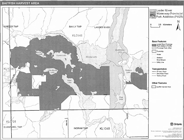
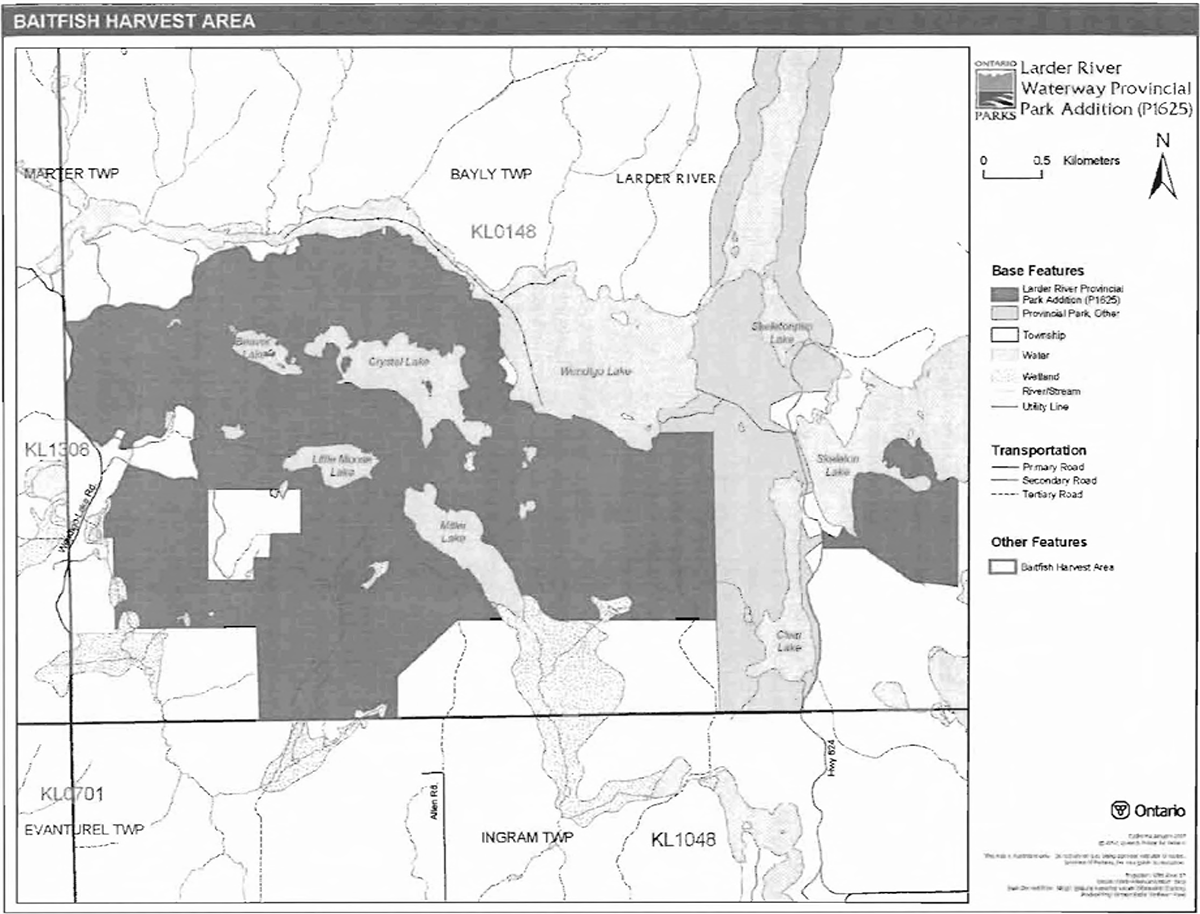
Commercial baitfish harvesting
Larder River Waterway Park Addition falls within on baitfish harvest area KL0148 (Figure 5). This baitfish harvest area is currently allocated. Existing commercial baitfish harvesting may continue where the activity has been licensed or permitted since January 1, 1992. This activity may be subject to conditions identified through future park planning or fisheries management plans. New baitfish licenses will not be permitted (OMNR 2000; 2003).
Fish stocking
The stocking of native fish species may be considered through future planning, with full public and Aboriginal consultation. Non-native fish species will not be deliberately introduced into park waters (OMNR 1992).
6.0 Operations policies
6.1 Recreation management
Future planning, with full public and Aboriginal consultation, will review direction on motorized and non-motorized recreation uses.
Figure 5: Baitfish Harvesting Areas
6.1. 1 Motorized recreation
Motorboats
The use of motorboats is permitted to continue, unless park values are being threatened (OMNR 2004a).
Aircraft
Aircraft landings may be permitted within this park addition (OMNR 2004a). All aircraft landings are subject to regulation and valid aircraft landing permits issued by the park superintendent under the authority of the Provincial Parks Act.
Snowmobiles
There are no authorized snowmobile routes within Larder River Waterway Park Addition. Snowmobile use on established routes for access to private land in-holdings, LUPs, and recreational ice fishing may continue unless park values are threatened. Off-trail snowmobile use is not permitted within the park. Proposals for new snowmobile trails may be considered though future planning with public and Aboriginal consultation (OMNR 2000).
All-terrain vehicles
There are no authorized ATV trails within the park addition. The existing use of roads and trails to access LUPs is permitted continue unless this use threatens park values. ATV use may be permitted on old forest access and tertiary roads. Off-road use of ATVs will not be permitted within the park. Proposals for new trails may only be considered through future planning with public and Aboriginal consultation (OMNR 2000).
6.1.2 Non-motorized recreation
Camping
There are no managed campsites in Larder River Waterway Park Addition. If there is an identified need, new campsites may be considered (OMNR 2004a). Infrastructure will be permitted in order to protect park features and values in response to use, environmental deterioration and environmental protection requirements. Any proposed development in the park must fulfill the requirements of the Environmental Assessment Act.
Hiking
There are no authorized hiking trails within the boundaries of this provincial park. If there is an identified need, the development of new hiking trails may be considered. Trail infrastructure to protect park values and features will be permitted. Any proposed development within the park is subject to Environmental Assessment Act requirements.
Canoeing/kayaking
Existing uses may continue, unless park values are threatened (OMNR 2004a). Infrastructure to protect park features and values may be permitted and developed in response to use, environmental deterioration and environmental protection requirements.
6.1.3 Emerging recreational Uses
There are emerging recreational uses for which there is limited or no policy to deal with their management (e.g., adventure racing and geocaching). The park superintendent will use legislation, policy, and guidelines which are in place to manage emerging uses in the interim.
6.2 Development
Infrastructure to protect park features and values may be permitted and developed in response to use, environmental deterioration, and environmental protection requirements. Any proposed development within the park is subject to the Environmental Assessment Act.
6.3 Commercial tourism
New commercial tourism facilities may be considered where they would be consistent with park policy (OMNR 2004a). Any development must meet the requirements of the Environmental Assessment Act. Existing authorized tourism facilities may continue subject to management prescriptions determined through future planning. Existing tourism facilities (e.g., LUPs, leases) may be eligible for enhanced tenure, and decisions will be made through future planning.
7.0 Cultural resources
An assessment of the cultural resources specific to the park has not yet been completed. The management of any cultural values within this park will be directed toward protection and heritage appreciation (OMNR 1992).
8.0 Heritage education
Literature and other supporting information may be developed to describe the park in the context of Ontario’s provincial park system. Boundary limits, significant heritage features and permitted uses of the may be included in park literature.
Prospective park visitors may be informed about the sensitivity and significance of park values through park literature.
9.0 Research
Scientific research by qualified individuals which contributes to the knowledge of natural or cultural history, or to environmental or recreational management, may be encouraged in the park. Ontario Parks will encourage institutions, such as universities, to undertake research projects.
All research programs will require the approval of Ontario Parks and are subject to park policy and other applicable legislation. Any materials removed from the park will remain the property of Ontario Parks.
Approved research activities and facilities will be compatible with the park’s protection objective. Any site which is affected by research will be rehabilitated as closely as possible to its original state. Environmental Assessment Act requirements will apply.
10.0 References
Aikins, M., 2003. Natural Heritage Area-Life Science Checksheet: P1625 Larder River Provincial Park Addition.
Environmental Assessment Act, 1990.
Fish and Wildlife Conservation Act, 1997.
Fisheries Act, 1985.
Frey, E., and D. Duba, 2002. Earth Science Inventory Checklist: P1625 Larder River Waterway Park Addition.
Harper, T., 2002. Larder River Provincial Park Addition (P1625) Recreation Inventory Report Version 1.1. October 2002.
Migratory Birds Convention Act, 1994.
Ontario Ministry of Natural Resources, 1974. A Topical Organization of Ontario History. Historic Sites Branch Division of Parks.
Ontario Ministry of Natural Resources, 1992. Ontario Provincial Parks Planning and Management Policies. 1992 Update.
Ontario Ministry of Natural Resources, 1998. Larder River Provincial Park Management Plan. Queen’s Printer for Ontario.
Ontario Ministry of Natural Resources, 1999. Ontario’s Living Legacy Land Use Strategy. July 1999. Queen’s Printer for Ontario.
Ontario Ministry of Natural Resources, 2000. Ontario’s Living Legacy Land Use Strategy (Policy Clarification).
Ontario Ministry of Natural Resources (OMNR), 2003. Directions for Commercial Resource Use Activities in Provincial Parks and Conservation Reserves. 5 pp.
Ontario Ministry of Natural Resources, 2004a. Crown Land Use Policy Atlas.
Ontario Ministry of Natural Resources, 2004b. Forest Fire Management Strategy for Ontario.
Ontario Ministry of Natural Resources, 2005a. A Class Environmental Assessment for Provincial Parks and Conservation Reserves.
Ontario Ministry of Natural Resources, 2005b. Summary of Proposed "Disentanglement" Strategies for Recommended Protected Areas and Pre-existing Mining Lands.
Ontario Ministry of Natural Resources, 2006. List of Forest Management Units (MU) in Ontario (2006-2007). Online. Accessed January 29, 2007.
http://ontariosforests.mnr.gov.on.ca/spectrasitesNiewers/showArticle. cfm?id =C74F77D4-68C741A6-
8D96FB6079073782&method=DISPLAYFU LLNOBARNOTITLE_R&ObjectlD=C74F77D468C7-
41A6-8D96FB6079073782&lang=FR&lang=EN&lang=FR&iang=EN [Link no longer active]
Provincial Parks Act, 1990.
Appendix A: Background information
| Name | Larder River Waterway Park Addition |
|---|---|
| Classification | Waterway |
| Ecoregion /Ecodistrict | 3E / 3E6 |
| OMNR Administrative Region/District | Northeast Region I Kirkland Lake District |
| Total Area (ha) | 1,535 |
| Regulation Date and Number | May 2002 (O. Reg.147/02) |
Representation Earth science:
Larder River Waterway Park Addition is within the Cobalt Embayment of the Paleoproterozoic 2.4 to 2.2 Billion Years Old (Ga) Huronian Supergroup of the Southern Province of the Precambrian Shield. Argillite, siltstone, sandstone, and conglomerate of the Cobalt Group Gowganda Formation outcrops are distributed extensively throughout the park. The subhorizontal Gowganda Formation is intruded by a Paleoproterozoic diabase sill of the 2.22 Ga Nipissing dike swarm and sheet intrusions, and one late Proterozoic dike of the circa 1.14 Ga Abitibi swarm. The representation of these geological environments in Larder River Waterway Park Addition contributes to the conservation of the Early Aphebian Huronian Stable Platform Precambrian environment theme (Frey and Duba 2002).
The bedrock geology of Larder River Waterway Provincial Park Addition is considered to be regionally significant for its extensive representation of components of the Gowganda Formation. The park addition is also regionally to provincially significant for its representation of a Nipissing diabase sill. The Abitibi diabase dike may be unique to the provincial park system and may therefore be provincially significant (Frey and Duba 2002).
Thin sandy ground moraine till, deposited approximately 11,000 years ago (11 ka) by the southeastward advancing Superior Lobe of the Late Wisconsinan continental ice sheet, remains in bedrock pockets in the park addition. The surficial deposits of the park are mainly glaciolacustrine clays and silts and sands. Their distribution varies greatly with local bedrock topography. Significant accumulations also are on the plateau surfaces. The lacustrine sediments were deposited approximately 9 to 8 ka, when proglacial Lake Barlow flooded the area during the northward recession of the Superior Lobe. The coarser sediments were reworked by glaciofluvial meltwater (Frey and Duba 2002).
Life science:
The area is characterized by moderately-broken plains of granitic and low-base bedrock which is thinly covered with granitic and low-base sand and silty sand. The mantle of soil is generally thin with local pockets of deeper silt, clay, and sand. The well drained uplands contain podsols and boreal brown podsolics, and peats and peat gleis occur on the poorly-drained materials in depressions (Aikins 2003). Four major (i.e., 100.00 to 1000.00 hectares), four modest (i.e., 10.01 to 100.00 hectares), and one small (10.10 to 100.00 hectares) ecosite representation occurs within the park addition. Jack pine is dominant with 404.1 hectares in the park addition.
The area is within the Atlantic and Englehart River watersheds. In general, the area is composed of a series of small, nutrient-rich lakes which are embedded in a mixed-conifer community, with several open wetlands and bedrock outcrops. Notable cliff communities (approximately 100 metres in height) can also be found on the shores of Wendigo and Skeleton lakes. Larder River Waterway Park Addition contains weakly-broken bedrock covered with aspen (Populus species). Jack pine (Pinus banksiana). spruce (Picea spp.), white birch (Betula papyrifera), brush and alder (Alnus spp.), and treed wetlands. The park addition also contains open wetlands on lacustrine deposit. Bedrock areas characteristically covered with larch (Larix laricina), aspen, brush and alder, and white birch (Aikins 2003).
Wildlife values within the park are managed in WMU 28. Species inhabiting or using the area are typical of those found within the Great lakes St. Lawrence Forest. The area provides important habitat for moose (feeding and calving}, raptors (nesting},Great Blue Heron (Ardea herodias) and cold and coolwater fish species (Aikins 2003). Fish species inhabiting the park addition include Northern Pike (Esox lucius), Yellow Perch (Perea flavescens), Rock Bass (Ambloplites rupestris), Pumpkinseed (Lepomis gibbosus), Brook Trout (Salvelinus fontinalis), Spottail Shiner (Notropis stramineus), White Sucker (Catostomus commersom), and Golden Shiner (Notemigonus crysoleucas) (Aikins 2003).
Cultural resources:
There are currently no reports describing the cultural resources of Larder River Waterway Park Addition.
Recreation:
The main recreational features in Larder River Waterway Park Addition include sport fishing, canoeing, hunting, and hiking.
The park addition is used by local people and cottage owners. While there are no canoe routes in the park, there are two nearby routes: the Wendigo Lake Canoe Route and the Larder River Canoe Route, which is within the existing Larder River Provincial Park. The park addition would be suitable for developing semi-remote camping opportunities and hiking trails. Unauthorized ATV use likely occurs within the park on existing tertiary access roads and trails (Harper 2002).
Inventories
| Survey Level | Earth Science | Life Science | Cultural | Recreational |
|---|---|---|---|---|
| Reconnaissance | Frey and Duba 2002 | Aikins 2003 | Harper 2002 |
Footnotes
- footnote[1] Back to paragraph Transfers include situations where a license is surrendered with a request that it be immediately reissued to another individual or organization that is assuming an existing operation. Trap cabins are considered part of a trapline and would be transferred with the trapline for the purposes of trapping. If a trapline license is revoked or surrendered, all portions of the registered line within the park will be rescinded from the legal description of the trap line (OMNR 2003).