Little Abitibi Provincial Park Management Statement
This document provides direction on the management of Little Abitibi Provincial Park.
Interim Management Statement
2006
Approval statement
I am pleased to approve this Management Statement for Little Abitibi Provincial Park. The Northeastern Ontario Strategic Land Use Plan and the Cochrane District Land Use Guidelines identified this area as a waterway/natural environment class park. Little Abitibi Provincial Park was regulated under the Provincial Parks Act in February of 1985 (O.Reg. 279/85).
This Interim Management Statement provides direction for the protection and management of Little Abitibi Provincial Park. This document will govern all activities occurring within the park and focus on custodial management required to protect park values and ensure public safety.
Paul Bewick
Zone Manager
Northeast Zone
Ontario Parks
Date: May 23, 2006
1.0 Introduction
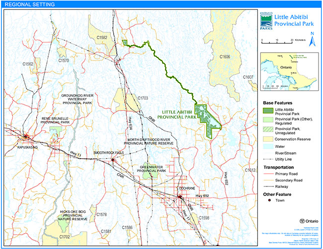
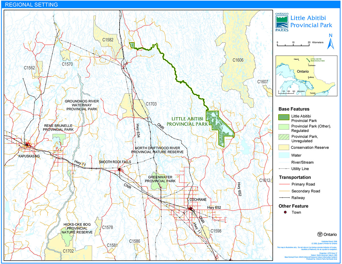
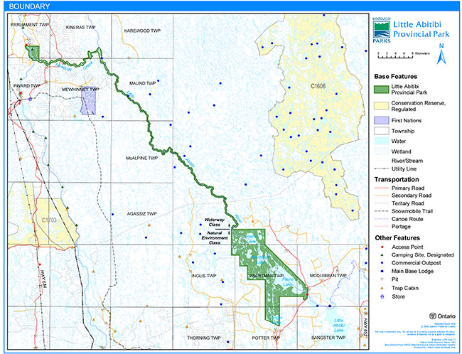
Little Abitibi Provincial Park provides waterway and natural environment class representation in the Lake Abitibi Ecodistrict (3E-1). Located approximately 65 km northeast of Cochrane, this linear park is anchored in the south by a number of large lakes on the Little Abitibi River system, notably Pierre, Montreuil and Harris lakes (Figure 1). The park follows the Little Abitibi River from the outlet at Harris Lake for approximately 70 km to a diversion dam, constructed in 1963 to divert water into New Post Creek. It then follows a 4 km diversion channel to New Post Creek and 16 km of New Post Creek to the confluence at the Abitibi River. At this point, the park boundary expands to include a portion of the Abitibi River and adjacent land base to protect a significant historical site (Figure 2). The park was regulated under the Provincial Parks Act, Ontario Regulation 279/85 in February 1985 and encompasses a total area of 20,296 hectares.
Little Abitibi Provincial Park was originally identified as two separate candidate parks; the Little Abitibi River-New Post Creek waterway candidate and the Pierre-Montreuil Lakes natural environment candidate. At the time the park was regulated, no decision was made regarding classification. The Crown Land Use Policy Atlas (CLUPA) provides the land use direction regarding classification. CLUPA states the park will be managed with two classifications based on the original candidates recommended in the Cochrane District Land Use Guidelines. The Little Abitibi River-New Post Creek section will be managed as a waterway class park and the Pierre- Montreuil Lakes section will be managed as a natural environment class park (Figure 2).
Little Abitibi Provincial Park is a non-operating park and remains relatively undeveloped. However, there have been an increasing number of management issues. The purpose of this Interim Management Statement (IMS) is to provide direction to ensure custodial management of park resources. If deemed necessary, a park management planning process may be conducted at a future date. At that time, significant decisions regarding resource stewardship, operations, development and permitted uses will be made.
1.1 Objectives
Little Abitibi Provincial Park will be managed according to the four objectives for provincial parks:
Protection: To protect provincially significant elements of the natural and cultural landscapes of Ontario.
Recreation: To provide provincial park outdoor recreation opportunities ranging from high-intensity day-use to low-intensity wilderness experiences.
Heritage Appreciation: To provide opportunities for exploration and appreciation of the outdoor natural and cultural heritage of Ontario.
Tourism: To provide Ontario’s residents and out-of-province visitors with opportunities to discover and experience the distinctive regions of Province.
Figure 1: Regional Setting
Enlarge Figure 1: Regional Setting
Figure 2: Park Boundary
Enlarge Figure 2: Park Boundary
2.0 Management context
Park management will follow direction from the following sources:
- Northeastern Ontario Strategic Land Use Plan (OMNR 1982)
- Cochrane District Land Use Guidelines (OMNR 1983)
- Ontario’s Living Legacy Land Use Strategy (OMNR 1999) and related policy clarification documents (OMNR 2000, OMNR 2003);
- Ontario Provincial Parks Planning and Management Policies:1992 Update (OMNR 1992)
- Ontario Crown Land Use Policy Atlas (OMNR 2004); and the
- Provincial Parks Act (RSO 1990).
Custodial management will protect park values and ensure public health and safety. Ontario Parks will ensure that policy and environmental assessment requirements are implemented.
2.1 Environmental assessment
As part of the Ontario Ministry of Natural Resources, Ontario Parks is a public sector agency that is subject to the Environmental Assessment Act. Park management will be carried out in accordance with the legislation, policies and guidelines that are required under the MNR Class Environmental Assessment for Provincial Parks and Conservation Reserves.
3.0 Park features and values
The park was originally identified in the Northeastern Ontario Strategic Land Use Plan (OMNR 1982) and the Cochrane District Land Use Guidelines (OMNR 1983) as two separate candidate parks; the Little Abitibi River – New Post Creek waterway candidate and the Pierre-Montreuil Lakes natural environment candidate. At the time the park was regulated, no decision was made on classification. As a result, the park will be managed as follows. The Little Abitibi River-New Post Creek section will be managed as a waterway class park and the Pierre-Montreuil Lakes section will be managed as a natural environment class park.
Waterway class parks protect outstanding recreational water routes and representative natural features and historical resources and provide high quality recreational and educational opportunities.
Natural environment class parks protect outstanding recreational landscapes and representative natural features and historical resources and provide high quality recreational and educational opportunities.
3.1 Geological features
Earth science inventories were completed by Frey (1975 and 1980) and by Mackenzie et al. (1983).
The following is a description of the earth science features within Little Abitibi Provincial Park from the Little Abitibi Provincial Park Background Information Document (OMNR 1986):
The park is located in both the Abitibi Upland and Hudson Bay Lowland physiographic regions and is characterized by weekly broken deep clay till plain and weekly broken deep lacustrine clay plain. The land surface dips gently northward, dropping 57 m from the southern tip of Zinger Lake to the northwest portion of Harris Lake. Most of the landscape is nearly flat to slightly hummocky.
The park is underlain by bedrock which is Precambrian in age and is located in the Superior Structural Province of the Canadian Shield. Three major Precambrian bedrock complexes occur within the park. These include a migmatite-metasedimentary-metavolcanic complex, an ultramafic intrusive complex and the Kapuskasing Granulite Complex which were formed during the early, late-early and early-middle Precambrian respectively.
Numerous faults and fractures are present within the park and affect the drainage and topography in some areas. The most significant fault in the park occurs below the 25 m waterfall on New Post Creek approximately 1 km from its confluence with the Abitibi River. This vertical fault includes an 8 m wide canyon which extends for 200 m below the falls.
Little is known about the metallic resources in the park area. Initial surveys indicate the exploration potential for base and precious metals is low throughout much of the park area. The Kapuskasing Granulite Complex may hold the highest potential for minerals within the park as favourable conditions exist for anorthosic rocks and carbonate-alkalic intrusions which are known to host cobalt, uranium, thorium, apalite, rare earths and nepheline.
The surficial material that covers much of the park is a result of glacial and deglacial activities during the late Wisconsian. Glacial features and materials in the area include moraines, till, eskers and lacustrine deposits.
The first discernible ice advance over the area deposited stony, sandy till derived from the bedrock of the region. About 9,000 years ago, the ice margin reached the park area. Meltwaters at that time resulted in the development of proglacial Lake Ojibway. Bounded by ice to the north and the drainage divide to the south, the development of the proglacial lake resulted in the deposition of lacustrine silts and clays throughout the area.
Approximately 8,700 years ago, the ice margin reached a position roughly equivalent to the present east-west trending section of New Post Creek. The ice front then remained stationary, which resulted in a large moraine named the Pinard Moraine being deposited between the ice and proglacial Lake Ojibway.
The ice front then retreated to a position just south of James Bay. About 8,100 years ago, a new advance began. Named the Cochrane II, the ice sheet pushed southward over the park area resulting in the deposition of a capping layer of clay to silty-clay till over the land surface.
There are several esker complexes within the park, two of which are noteworthy. One of these is traceable from Zinger Lake north along a chain of small lakes toward Pierre Lake. Another occurs approximately 35 km down the Little Abitibi River from Harris Lake. Studies suggest that the eskers in this area were formed prior to the development of proglacial Lake Ojibway.
The park area is considered to be of moderate to high significance in offering a representative sample of Precambrian and Quaternary activities that have occurred in this area of northeastern Ontario.
The Pinard Moraine has been suggested as one of the most prominent northern moraines in the Hudson Bay Lowlands. This feature extends eastward over a broad area, from west of the Abitibi River across the New Post Creek area to the east.
The esker complex in the Zinger Lake area is significant for study purposes as it preserves a Late Wisconsian esker under a blanket of Cochrane Till, an earth-forming process which has received only speculative attention to date.
The exposure of interbedded Cochrane Till and lacustrine silt and sand at the north end of Zinger Lake identifies a portion of the Cochrane lobe as having advanced into a proglacial lake. This feature is regionally unique within Northeast Zone and possibly is the only one of its kind.
3.2 Biological features
A life science inventory of the Pierre-Montreuil Lakes section of the park was completed by Riley (1978). Additional life science-related studies have been completed since that time, primarily focusing on fisheries management.
The following is a description of the life science features within Little Abitibi Provincial Park from the Little Abitibi Provincial Park Background Information Document (OMNR 1986):
The park area is composed of forests typical of a colder ecoclimate in an area underlain by poorly decomposed organic materials and saturated soils. Black spruce dominates, mixed with tamarack (larch) and some eastern white cedar. A mixed forest of white birch, balsam fir, white spruce and aspen occur where drainage is improved with jack pine occurring on well drained sand deposits.
To date, 415 species of vascular and non-vascular plants have been identified in the park. The major habitats include open shallow waters, marshes, bogs, fens, swamps, black spruce forests, jack pine forests, bedrock, esker slopes, islands, sand-gravel shores and disturbed sites.
The fauna in the park area is generally representative of the Clay Belt region. Big game species include moose and black bear. Woodland caribou are reported to have been occasionally sighted; and are considered a regionally significant species. There is no open hunting season for caribou. Status Indians are permitted to harvest whatever they require for food. Fur-bearing species include beaver, red fox, timber wolf, muskrat, mink, marten, otter, lynx and fisher.
To date, 68 species of birds have been identified in the park, although only preliminary investigations have been carried out. Various osprey and their nests have been sighted throughout the park area.
The lakes within the park are characterized as clean, warm waterbodies. The principle sport fish are northern pike and walleye. Brook trout are reported to occur in the Little Abitibi River. It is thought that these likely originate from the various feeder streams and rivers that flow into the Little Abitibi River. The park has long been a popular fishing area for recreationists.
One of the most significant life science features that has been identified in the park is a red pine stand that is estimated to be 300+ years old. This is thought to be one of the most northerly examples remaining in this part of the province (Riley 1978). This stand is considered to be provincially significant (Del Monte, 1984).
3.3 Cultural setting
A detailed inventory of the cultural features of the provincial park has not been completed. There are several known culturally significant areas within the park. These include the New Post Hudson’s Bay Company site on the Abitibi River and a homestead and cemetery on Harris Lake.
The following is a description of the cultural resources within Little Abitibi Provincial Park from the Little Abitibi Provincial Park Background Information Document (OMNR 1986):
Although no thorough archaeological inventory has been carried out in the park, limited surveys and incidental discoveries of artifacts provide evidence of occupation of the area by aboriginal people prior to the arrival of Europeans in the area. These would include Cree, Ojibway and Northern Algonquin peoples.
The Pierre Lake chain would have been a favoured area as it was connected to the Abitibi River by means of a short portage from the Little Abitibi River to New Post Creek.
It has been speculated that first contact or knowledge of Europeans in this area may have occurred circa the early 1600s. The first post in the area was established by the Chevalier De Troyes on Lake Abitibi. From that point he led a successful expedition against English posts on James Bay.
The Hudson’s Bay Company established New Post on the Abitibi River in 1867. This post is located on the east bank of the river about 2 km south of the junction of New Post Creek. It remained in operation until 1920, and was the only company post which existed between Moosonee and Lake Abitibi. Studies have determined that by 1900, the post consisted of four buildings: a factor’s residence, a second house, a general trading store and a storehouse. A dozen tents or tepees indicated the presence of a limited number of aboriginal people. At the rear of this clearing there is a small graveyard which dates from the Hudson’s Bay Company period. It contains 11 known graves.
The site is currently being eroded due to high water levels on the Abitibi River caused by the Otter Rapids Generating Station. Initial studies suggested that New Post was of local significance. However, more recent studies (Finlayson, 2005) suggest that it may have regional and possibly provincial significance.
There have been numerous other discoveries of artifacts on the Pierre, Montreuil and Harris lakes chain, the most significant being a cemetery and former homestead on the north shore of Harris Lake near its outlet at the Little Abitibi River.
Any future planning will be done within the context of A Topical Organization of Ontario History (OMNR 1974) which provides a provincial framework. In addition, discussions with First Nations, other agencies and stakeholders may be carried out to identify cultural heritage values and features within the park and their significance. This information may be used to develop management guidelines to conserve and protect representative archaeological and historical values and features, or to provide direction for further research.
3.4 Recreation
There are no developed facilities within the park. The park provides backcountry camping, canoeing and fishing opportunities. Hunting also occurs within the park boundary. Motor boating occurs within the park, generally to support sport fishing. Photography, heritage appreciation, and self-guided interpretation of the earth and life science features could also be supported in this park.
Use of the park is primarily associated with sport fishing. The park receives relatively high use in the spring and early summer from local residents and from the travelling public. People travel from as far away as the United States to fish here. Currently, there are no concerns regarding the fish populations. However, the impacts on the park associated with camping are becoming a concern. These include campsite enlargement, compaction, erosion, litter, human waste, cutting of trees etc.
Two existing land use permits (LUP) are located within the Little Abitibi River-New Post Creek waterway section of the park. These LUPs are for commercial outpost camps. The level of use these camps receive is unknown but is thought to be relatively low.
Other recreational activities that may occur include wildlife viewing, photography and self-guided exploration of park features.
4.0 Aboriginal use
Little Abitibi Provincial Park is within the Nishnawbe Aski Nation (NAN) Treaty 9 Area (1905-06). Nearby aboriginal communities include the Taykwa Tagamou Nation, the Moose Cree First Nation and the Wahgoshig First Nation.
First Nations have expressed interest in and have shared knowledge of the park and surrounding area. Aboriginal communities may have used the area for hunting, trapping, fishing, gathering and travel. These uses may continue, subject to public safety, conservation and other considerations.
Any communications or cooperation between aboriginal communities and MNR for planning and operations purposes will be done without prejudice to any future discussions or negotiations between the Government of Ontario and aboriginal communities.
5.0 Stewardship policies
The removal, damage or defacing of Crown property, natural objects, relics and artifacts is not permitted in provincial parks (Provincial Parks Act RSO 1990).
5.1 Terrestrial ecosystems
5.1.1 Vegetation
Harvesting
Commercial forest harvesting and renewal activities are not permitted within this provincial park (OMNR 1992, OMNR 1999, OMNR 2004).
New operations for the commercial harvesting of non-timber forest products (e.g. wild rice, Canada yew, etc.) will not be permitted within the boundary of Little Abitibi Provincial Park (OMNR 2004).
There are no fuelwood cutting permits issued for Little Abitibi Provincial Park. No new permits will be issued (OMNR 2000, OMNR 2004).
Non-native plants
Non-native plant species will not be deliberately introduced into the park. Where non-native plant species are already established and threaten park values, a strategy may be developed to control the species (OMNR 1992).
Insects and disease
Insects and diseases may be managed where the aesthetic, cultural or natural values of Little Abitibi Provincial Park are threatened (OMNR 1992).
Control measures will follow guidelines established by the Ontario Ministry of the Environment (MOE) and MNR. Biological controls will be used whenever possible (OMNR 1992).
Fire
Little Abitibi Provincial Park is located within MNR's Boreal Fire Management Zone. In accordance with existing provincial park policy and the Forest Fire Management Strategy for Ontario, forest fire protection will be carried out in Little Abitibi Provincial Park, as on surrounding lands.
Whenever feasible, MNR's Forest Fire Management program will use techniques which minimize damage to the landscape during response efforts (OMNR 2004a).
In order to protect significant park values from the risk of forest fire, it may be necessary to restrict public access to certain areas. This may require the closure of some existing campsites.
5.1.2 Wildlife management
The park is located in Wildlife Management Unit (WMU) 26. The removal or harassment of non-game animals is not permitted in provincial parks (Provincial Parks Act RSO 1990).
Status Indians exercising treaty rights are permitted to hunt and trap within the boundary of Little Abitibi Provincial Park (OMNR 1992; OMNR 2000).
Hunting
Sport hunting is permitted to continue within the boundary of Little Abitibi Provincial Park.
The Fish and Wildlife Conservation Act (O. Reg. 378/00, Schedule 10), as well as the Federal Migratory Birds Convention Act, governs any hunting activity within the park. The Ontario Hunting Regulations Summary contains regulations specific to this area. It is illegal to harvest bullfrogs or snapping turtles in provincial parks (OMNR 2004b).
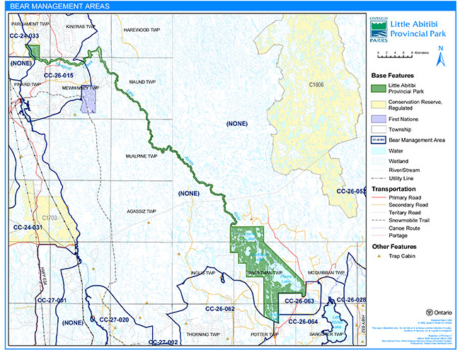
Bear Management Areas
There are two licensed bear management areas (BMA) that overlap the park boundary: CC-26-015 and CC-24-033. There are also two licensed BMAs immediately adjacent to the park: CC-26-063 and CC-26-062. (Figure 3)
Commercial bear hunting will only be permitted in Little Abitibi Provincial Park within BMA CC-26-015 and CC-24-033. No new BMA licences will be issued. (OMNR 2000, OMNR 2004). If a BMA license is revoked or surrendered, all portions of the BMA within the park will be rescinded from the legal description of the BMA (OMNR 2003).
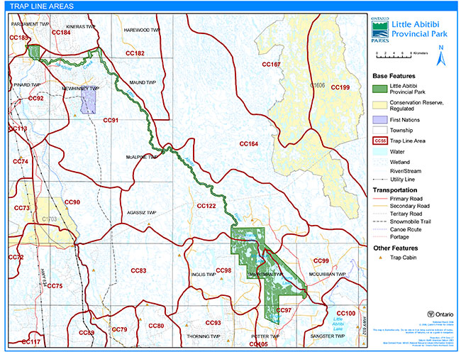
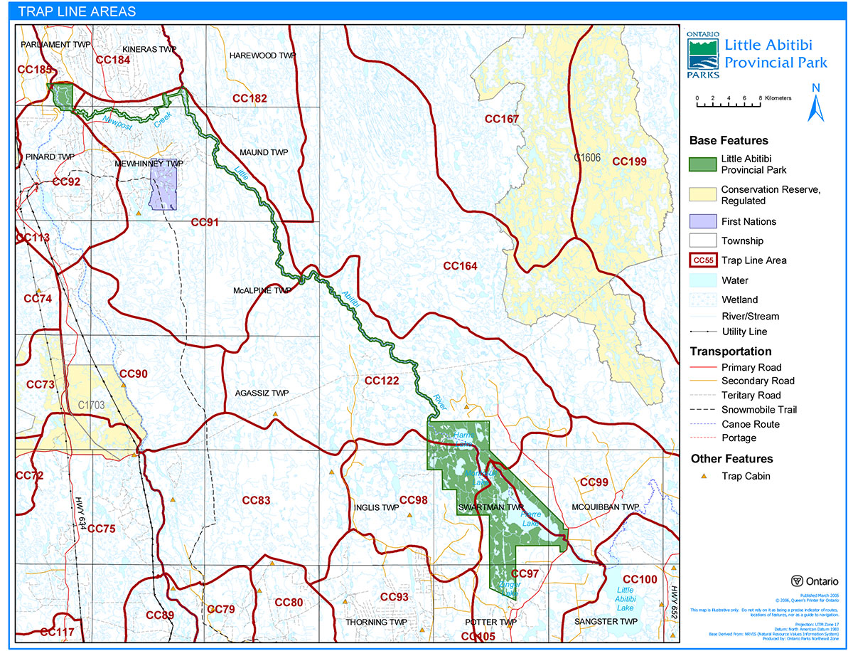
Trapping
The park includes portions of six licensed trap lines: CO-91, CO-92, CO-97, CO-98, CO-99, CO-122, CO-184, and CO-185 (Cochrane District). (Figure 4)
There are no authorized trap cabins located within Little Abitibi Provincial Park.
Existing commercial fur harvesting will be permitted to continue indefinitely, except in wilderness or nature reserve zones which may be determined through future planning.
New operations including trap line cabins and trails will not be permitted. Relocation of existing trails may be considered through future park management planning in accordance with ecological principles (OMNR 2003).
"Existing use" is defined as that use supported by an active license, permit or other formal authorization. If this authorization lapses, the activity is no longer considered an existing use (OMNR 2000). However, if there is a record of activity since January 1, 1992, the license can be re-issued (OMNR 2003).
Transfers of active trap line licenses are permitted, subject to a review of potential impacts and the normal transfer or renewal conditions that apply. Transfers include situations where a license is surrendered with a request that it be immediately reissued to another individual that is assuming an existing operation. If a trap line license is revoked or surrendered, all portions of the registered line within the park will be rescinded from the legal description of the trap line (OMNR 2003).
Figure 3: Bear Management Areas
Enlarge Figure 3: Bear Management Areas
Figure 4: Trap Line Areas
Enlarge Figure 4: Trap Line Areas
5.1.3 Industrial resources
Extraction of sand or gravel is not permitted within provincial parks. There are no active aggregate pits within the park.
Mineral exploration and mining are not permitted in provincial parks. There are no existing mining claims within Little Abitibi Provincial Park. All lands within the park have been withdrawn from mining activity under the Mining Act.
5.1.4 Access and crossings
Access
Little Abitibi Provincial Park has traditionally been accessed by road and water. There is one designated access point located on the Little Abitibi River east of Pierre Lake. Road access to the southern portion of the park is by forest access road. Another informal access point provides access to Zinger Lake in the extreme southern portion of the park.
New Post Creek can be accessed by road via Ontario Power Generation’s Otter Rapids Road.
The park can also be accessed via water. The Little Abitibi Lake Access Point (outside the park) is located on Highway 652 and provides an alternative access to the Little Abitibi River. This route is used to a very limited degree due to a series of challenging rapids between Little Abitibi Lake, Williston Lake and Pierre Lake.
Access to New Post Falls in the extreme northwest portion of the park has traditionally been by water and land. A forest access road leads to a short walking trail that ends on the north side of New Post Creek with a view of New Post Falls. Park visitors can also launch a boat or canoe at Abitibi Canyon on the Abitibi River and travel downstream to New Post Creek. An unauthorized trail was recently cut from the existing walking trail to the top of the falls. Use of this trail is not permitted.
Access to the park will be permitted as follows: Road access to the Pierre Lake Access Point and Zinger Lake Access Point in the south and to the New Post Falls trailhead in the north. Water access via the Little Abitibi River and Abitibi River will also be permitted.
Roads
One road crosses the Little Abitibi River-New Post Creek section of the park. There are no roads in the Pierre-Montreuil Lakes section of the park.
Where existing roads are essential for continued access to land use permits, patent land, etc. beyond the park boundary, and alternative road access does not exist or road relocation is not feasible, existing roads will continue to be available for access (OMNR 2004).
The Otter Rapids Access road crosses New Post Creek in the northwest portion of the Little Abitibi River-New Post Creek Section of the park. The road provides access to Ontario Power Generation’s Otter Rapids Generating Station on the Abitibi River north of the park and to adjacent crown land. Use and maintenance of this road will be permitted to continue.
Crossing of the Little Abitibi River-New Post Creek waterway section by new roads may be necessary. The number of crossings will be minimized and will be managed to reduce their impact on recreational and aesthetic values. Any future road crossings proposed through the park, where park lands are unavoidable, will be reviewed on a case-by-case basis. Protection of park values will be the priority. The proposal must meet all requirements of the Environmental Assessment Act.
New roads for non-park use will not be permitted within the Pierre-Montreuil Lakes natural environment section of the park.
Any proposed development, maintenance or upgrading of existing roads must meet all Environmental Assessment Act requirements.
Aggregate extraction is not permitted within the park. An external source of aggregate is required for road improvements and maintenance.
Railway
There are no railway corridors within Little Abitibi Provincial Park.
New railway crossings of the waterway class section of the park may be necessary to maintain essential public services outside of the park boundaries. The number of future crossings will be minimized and they will be managed to reduce their impact on recreational, aesthetic, cultural and biological values (OMNR 1992).
New railway crossings of the natural environment class section of the park will not be permitted.
Utility corridors
An old utility corridor crosses the Little Abitibi River-New Post Creek waterway section of the park. This corridor serviced the Detour Lake Gold Mine. The mine has been de-commissioned and the transmission line has been removed. However, there has recently been some discussion regarding redevelopment of the mine. If this project moves forward it is unclear at this time how electricity would be delivered to the site.
All public utilities (e.g. gas pipelines, transmission lines, communications towers, etc.) must avoid park lands wherever possible, however new utility corridor crossings may be necessary to maintain essential public services (OMNR 1992; OMNR 2004). The number of new crossings will be minimized where possible and will be managed to reduce their impact on recreational, biological, cultural and aesthetic values (OMNR 2004).
Any future utility corridors proposed through the park, where park lands are unavoidable, will be reviewed on a case-by-case basis. Protection of park values will be the priority. MNR's Environmental Assessment requirements must be met.
Recreational trails
Canoe Route: The Little Abitibi River Canoe Route begins at the Pierre Lake Access Point and travels north through Pierre, Montreuil and Harris lakes and then down the Little Abitibi River to New Post Creek. At this point, the canoe route travels west on New Post Creek to the Abitibi River. This canoe route offers several areas of white water and a remote setting. The total length of this route is approximately 144 km.
Another canoe route within the park starts at Zinger Lake and travels through a chain of lakes located along an esker. This route links into Pierre Lake. Canoeists can choose to continue along the Little Abitibi River Canoe Route, travel to the Pierre Lake Access Point or return to their starting point.
Hiking: There are no designated hiking trails in the park. There is an old walking trail leading from a forest access road to a view of New Post Falls in the extreme northwestern portion of the park. Use of this trail for pedestrian traffic will be permitted to continue provided there are no environmental problems. No motorized vehicles are permitted to use this trail.
Snowmobile Trails: There are no designated snowmobile trails in Little Abitibi Provincial Park.
ATV Trails: There are no designated ATV trails in Little Abitibi Provincial Park.
5.1.5 Adjacent land management
Forestry
The lands adjacent to the park are allocated to the Iroquois Falls Forest management unit (FMU # 12) and the Smooth Rock Falls Forest management unit (FMU # 40). Abitibi Consolidated Company of Canada (Iroquois Falls) is responsible for forest management planning on the Iroquois Falls Forest under the authority of a sustainable forest licence (SFL). The forest management plan was renewed in 2005 (OMNR 2005a).
Tembec Forest Resources Management Inc. (Timmins) manages the Smooth Rock Falls Forest. The current forest management plan was renewed in 2005 (OMNR 2005a).
Adjacent tourism facilities
There are a number of commercial tourism facilities, primarily remote or semi-remote outpost camps in the vicinity of Little Abitibi Provincial Park. It is unlikely that patrons of these facilities use the park as they are primarily fly-in operations focused on specific lakes.
General use areas
There are four General Use Areas adjacent to the park. These include G1745 Southern Resource Area, G1754 Northern Resource and Commercial Area, G2082 Remaining ("Straggler") Lakes (A), and G2085 Remaining ("Straggler") Lakes (B). The management priorities for these areas vary and are partly directed by the Cochrane District Remote (Wilderness) Tourism Strategy (OMNR 1997) which identifies areas where resource extraction activities are under special controls to mitigate their impacts on remote tourism values.
Generally speaking, the management objectives for the area to the south and west of the park are primarily focused on resource extraction including forestry and mineral exploration as well as crown land recreation. In the areas to the north and east of the park, commercial tourism is given a higher priority although resource extraction and crown land recreation still occur.
5.1.6 Land disposition
No new dispositions of Crown land for private use of individuals or corporations are permitted within the park (OMNR 2003).
Land use permits, licenses of occupation, unauthorized occupations
There are two commercial outpost camp land use permits (LUPs) within the park. These are located within the Little Abitibi-New Post Creek waterway section of the park.
A crown lease is held by Ontario Power Generation for the New Post Diversion Dam at the junction of the Little Abitibi River and New Post Creek in the Little Abitibi-New Post Creek section of the park.
Ontario Power Generation also holds a LUP for the bridge across New Post Creek on the Otter Rapids Access Road.
Patent land
There is no patent land within the park.
Boat caches
There are no authorized boat caches located within the park.
Watercraft are not to be left unattended in the park without written permission from the park superintendent (OMNR 1990).
5.2 Aquatic ecosystems
Sustaining quality water resources is integral to the protection of park values. The Ontario Ministry of Environment enforces applicable legislation and regulations for water quality.
5.2.1 Water management
The Abitibi River Water Management Plan (OPG 2006) governs the waters of the Little Abitibi River.
There is one existing water control structure within Little Abitibi Provincial Park. The New Post Diversion dam was constructed in 1963 to divert the flow of the Little Abitibi River through New Post Creek to the Abitibi River to supply additional generating capacity at the Otter Rapids Generating Station. This facility is now owned and operated by Ontario Power Generation (OPG) under the authority of a crown lease.
A number of environmental concerns have been identified regarding the dam and diversion channel. OPG has committed to address these concerns through the Abitibi River Water Management Plan (OPG 2006).
Concerns have also been identified regarding the erosion of the cultural heritage site at New Post on the Abitibi River. Some initial salvage and assessment work was undertaken in 2004, but further work will be required to either protect the site or salvage any significant artifacts before they are lost (Finlayson, 2005). The Abitibi River Water Management Plan acknowledges this concern but does not provide any specific direction or commitment to address the problem. OPG, the Ministry of Natural Resources and the Taykwa Tagamou Nation will need to develop a strategy for protection of the site. Currently, this issue has been identified as a "past grievance" which needs to be resolved by OPG and Taykwa Tagamou Nation before anything further can be done. If an agreement is reached, the Ministry of Natural Resources will ensure that any proposed protection or salvage activities meet the requirements of the Environmental Assessment Act.
New water control or hydroelectric developments are not permitted within the park (OMNR 1992; OMNR 2000).
5.2.2 Fisheries management
The waters in Little Abitibi Provincial Park support walleye and northern pike populations. Historic records suggest that anadromous brook trout may also have been found in the Little Abitibi River- New Post Creek waterway section of the park prior to construction of the New Post Diversion Dam.
Fisheries management will complement maintenance and enhancement of the native, self-sustaining fish populations.
Non-native fish
Non-native fish species will not be deliberately introduced into the waters contained in Little Abitibi Provincial Park (OMNR 1992).
Sanctuaries
There are three fish sanctuaries located within the park. One sanctuary is located on the Little Abitibi River between the Pierre Lake Road bridge and Pierre Lake. The second is located on the Little Abitibi River between the northern narrows on Pierre Lake and Red Pine point on Montreuil Lake. The third sanctuary extends from the mouth of the Thorning River on Harris Lake upstream to the junction with its first tributary creek. All three are in effect from April 15 to June 30. The legal descriptions for these sanctuaries can be found within the Recreational Fishing Regulations Summary.
Certain water bodies may be closed to fishing temporarily or permanently for fisheries research or management purposes (OMNR 1992).
5.2.3 Sport fishing
Sport fishing (including ice fishing) is permitted within waterway and natural environment class parks, subject to the Fish and Wildlife Conservation Act as well as the Fisheries Act. The Recreational Fishing Regulations Summary contains details on regulations and exceptions to those regulations for this area.
5.2.4 Commercial fishing
There are no commercial fishing operations within Little Abitibi Provincial Park. No new operations will be permitted (OMNR 2003).
5.2.5 Commercial baitfish harvesting
There are no commercial baitfish harvesting operations within Little Abitibi Provincial Park. No new commercial bait fish harvesting operations will be permitted (OMNR 2003).
5.2.6 Fish stocking
Zinger Lake located within the Pierre-Montreuil Lakes section of the park is stocked annually with lake trout. This stocking may continue if consistent with the Cochrane District MNR Fisheries Management Plan.
The stocking of native fish species may be considered through future park management planning. The stocking of non-native fish species will not be considered (OMNR 2004).
6.0 Operations policies
6.1 Recreation management
Future planning, with full public consultation, will review direction on motorized and non-motorized recreation uses.
6.1.1 Motorized recreation
Motorboats
Existing use may continue in the interim, unless park features or values are threatened (OMNR 2004). Long-term management direction for private and commercial boat use will be determined through park management planning, which includes public consultation (OMNR 2004).
Snowmobiles
There are no authorized snowmobile trails within the park.
Snowmobile use on established routes for access to trap lines or recreational ice fishing may be authorized to continue if it is determined that such use does not conflict with the protection of park features, values, or other recreational pursuits.
Off-trail snowmobile use is not permitted within the park.
Snowmobile access to New Post Falls is not permitted.
All-Terrain vehicles
There are no authorized all-terrain vehicle (ATV) trails located within the park.
New ATV trails may only be considered subject to future park management planning with full public consultation (OMNR 2000).
Off-road use of ATVs will not be permitted within park boundaries unless authorized by the superintendent under the authority of the Provincial Parks Act (OMNR 2000).
ATV access to New Post Falls is not permitted.
Aircraft
Aircraft landings are permitted in the park subject to regulation (OMNR 2004). A valid aircraft landing permit issued by the park superintendent is required. Long-term direction for aircraft landings will be determined through future planning.
6.1.2 Non-motorized recreation
Camping
Backcountry camping activities based on appreciation of natural and cultural heritage values will be encouraged within Little Abitibi Provincial Park (OMNR 1992).
Existing use may continue in the interim, unless park values are threatened (OMNR 2004). Infrastructure to protect park features and values will be permitted and developed in response to use, environmental deterioration and environmental protection requirements. Any development must meet the requirements of the Environmental Assessment Act.
In order to protect the natural and cultural heritage values within the park, it may be necessary to close some areas to camping under the Provincial Parks Act (RSO 1990). A number of existing campsites are in very poor condition as a result of continuous use. Impacts include campsite enlargement, soil compaction, erosion, the accumulation of human waste and garbage, the cutting of trees etc. In addition, park users have constructed semi-permanent shelters in a number of locations, which will need to be removed.
Hiking
There are no developed hiking trails within the park. There is an existing trail leading from a forest access road to a view of New Post Falls in the extreme northwestern corner of the park. Provided there are no significant environmental impacts, use of this trail will be allowed to continue for pedestrian traffic only. No motorized vehicles will be permitted on this trail.
If there is an identified need, new hiking trail development may be considered. Trail infrastructure to protect park values and features will be permitted. New trail development is subject to the requirements of the Environmental Assessment Act.
Canoeing/kayaking
Existing use may continue, unless park values are threatened (OMNR 2004). Infrastructure to protect park features and values will be permitted.
6.1.3 Emerging recreation uses
There are a number of emerging recreational uses for which there is limited or no policy to deal with their management (e.g. adventure racing, geocaching, etc). The park superintendent will use legislation, policy and guidelines that are in place in the interim to manage emerging uses. These include:
- High Risk Activities by Organized Groups in Provincial Parks
- Special Events in Provincial Parks
- Film Crews in Provincial Parks
- Provincial Parks Act: persons shall not excavate for any purposes; remove, damage or deface Crown property; litter, rappel or rock climb, leave a vehicle unattended; all persons must travel with a permit.
The park superintendent will work with adjacent MNR district offices to manage emerging uses.
6.2 Development
There is no existing park infrastructure within the park. Infrastructure to protect park features and values will be permitted and developed in response to use, environmental deterioration and environmental protection requirements. All development must meet the requirements of the Environmental Assessment Act.
6.3 Commercial tourism
Currently, there are two land use permits (LUP) for commercial tourism within Little Abitibi Provincial Park.
Existing authorized tourism facilities within the park are permitted to continue, but are subject to management prescriptions determined through management planning (OMNR 2004).
New commercial tourism facilities and trails may be considered where consistent with park policy (OMNR 2004). Any proposed development within park boundaries must fulfill the requirements of the Environmental Assessment Act.
7.0 Cultural resources
A complete assessment of the cultural resources of the park has not been conducted at this time.
Assessments have been undertaken at the New Post Hudson’s Bay Company site (Pollock, 1976, Finlayson, 2005). The earlier assessment suggested that the site was of local significance. However, the more recent assessment suggests that the site may have regional and possibly provincial significance. Both reports agree that action will be required to secure the site from further degradation.
Management of any cultural values within this park will be directed toward protection and heritage appreciation (OMNR 1992).
8.0 Heritage education
Basic literature and supporting information may be developed to describe Little Abitibi Provincial Park in the context of Ontario’s provincial park system. Park boundaries, significant heritage features and permitted uses within the park may be included in park literature.
Prospective park visitors may be informed about the sensitivity and significance of the park through park literature.
9.0 Research
Scientific research by qualified individuals that contributes to the knowledge of natural and cultural history or to environmental and recreational management will be encouraged in the park. Ontario Parks will encourage institutions to undertake research projects. All research programs will require the approval of Ontario Parks and are subject to park policy and other applicable legislation. Ontario Parks may approve the research of any natural or cultural features or values by qualified researchers. Any materials removed from the park will remain the property of Ontario Parks.
Approved research activities and facilities will be compatible with the park’s protection objective. Any site which is affected will be rehabilitated as closely as possible to its original state. Environmental Assessment requirements will apply.
10.0 References
Del Monte, M. 1984. Draft Interim Management Statement for the Little Abitibi Provincial Park, Cochrane District, Northern Region. Ontario Ministry of Natural Resources.
Finlayson, W. 2005. The 2004 Archaeological Salvage Excavations at the Hudson’s Bay Company’s New Post (DLHj-1) Parliament Township, Cochrane District, Ontario. This Land Archaeology Inc.
Fish and Wildlife Conservation Act, 1997.
Frey, E. 1975. Geology and Land Use Planning – Pierre-Montreuil Park Reserve.
Frey, E. 1980. Earth Science Report on the Pierre-Montreuil Park Reserve.
Mackenzie, I.D., D.A. Atkinson, and R.A. Lall. 1983. An Assessment of Earth Sciences Process and Features for Land Use Planning of the Little Abitibi River-New Post Creek Candidate Provincial Park. University of Waterloo.
Mining Act RSO, 1990.
Ontario Ministry of Natural Resources. 1974. A Topical Organization of Ontario History. Historic Sites Branch, Division of Parks.
Ontario Ministry of Natural Resources, 1982. Northeastern Ontario Strategic Land Use Plan
Ontario Ministry of Natural Resources. 1983, Cochrane District Land Use Guidelines.
Ontario Ministry of Natural Resources, 1986. Little Abitibi Provincial Park Background Information Document.
Ontario Ministry of Natural Resources. 1992. Ontario Provincial Parks Planning and Management Policies.
Ontario Ministry of Natural Resources, 1997. Cochrane District Remote (Wilderness) Tourism Strategy.
Ontario Ministry of Natural Resources. 1999. Ontario’s Living Legacy Land Use Strategy.
Ontario Ministry of Natural Resources. 2000. Ontario’s Living Legacy Land Use Strategy (Policy Clarification).
Ontario Ministry of Natural Resources. 2003. Directions for Commercial Resource Use Activities in Provincial Parks and Conservation Reserves. 5 pp.
Ontario Ministry of Natural Resources. 2004. Crown Land Use Policy Atlas.
Ontario Ministry of Natural Resources. 2004a. Fire Management Strategy for Ontario. Aviation and Forest Fire Management Branch.
Ontario Ministry of Natural Resources. 2004b. Hunting Regulations Summary.
Ontario Ministry of Natural Resources. 2004c. Recreational Fishing Regulations Summary.
Ontario Ministry of Natural Resources. 2005. Class Environmental Assessment for Provincial Parks and Conservation Reserves.
Ontario Ministry of Natural Resources. 2005a. List of Forest Management Units and Forest Management Plan Renewal Schedule 2005.
Ontario Power Generation. 2006. Abitibi Water Management Plan 2006-2016.
Pollock, J.W. 1976. New Post Hudson’s Bay Company Post, 1867-1920 – Abitibi River, Ontario, An Archaeological Inspection and Assessment. Ministry of Culture and Recreation.
Provincial Parks Act RSO, 1990.
Riley, J.L. 1978. The Vegetation of the Pierre-Montreuil Park Reserve, 1974-1975. Ontario Ministry of Natural Resources, Parks Planning Branch, Environmental Planning Section.
Appendix 1
Background information
| Name | Little Abitibi Provincial Park |
|---|---|
| Classification | Waterway/Natural Environment |
| Ecoregion/Ecodistrict | 3E-1 |
| OMNR Administrative Region/District | Northeast – Cochrane |
| Total Area (ha) | 20,296 ha |
| Regulation date & Number | 1985 (O. Reg. 279/85) |
Representation
Little Abitibi Provincial Park provides waterway and natural environment class representation in the Lake Abitibi Ecodistrict (3E-1). Located approximately 65 km northeast of Cochrane this linear park is anchored at its southern extremity by a number of large lakes on the Little Abitibi River system, notably Pierre, Montreuil and Harris Lakes. The park follows the Little Abitibi River from the outlet at Harris Lake for about 70 km to a diversion dam, constructed in 1963 to divert water into New Post Creek. It follows this 4 km diversion to New Post Creek and then the 16 km of New Post Creek, to the confluence at the Abitibi River. At the north end, a large node expands to include a portion of the Abitibi River and adjacent land base for the protection of a locally significant historical site.
Earth science:
Earth science inventories were completed by Frey (1975 and 1980) and by Mackenzie et al. (1983).
The following is a description of the earth science features within Little Abitibi Provincial Park from the Little Abitibi Provincial Park Background Information Document (OMNR, 1986):
The park is located in both the Abitibi Upland and Hudson Bay Lowland physiographic regions and is characterized by weekly broken deep clay till plain and weekly broken deep lacustrine clay plain. The land surface dips gently northward, dropping 57 m from the southern tip of Zinger Lake to the northwest portion of Harris Lake. Most of the landscape is nearly flat to slightly hummocky.
The park is underlain by bedrock which is Precambrian in age and is located in the Superior Structural Province of the Canadian Shield. Three major Precambrian bedrock complexes occur within the park. These include a migmatite-metasedimentary-metavolcanic complex, an ultramafic intrusive complex and the Kapuskasing Granulite Complex which were formed during the early, late–early and early-middle Precambrian respectively.
Numerous faults and fractures are present within the park and affect the drainage and topography in some areas. The most significant fault in the park occurs below the 25 m waterfall on New Post Creek approximately 1 km from its confluence with the Abitibi River. This vertical fault has an 8 m wide canyon which extends for 200 m below the falls.
Approximately one-third of the Little Abitibi River has not yet been mapped by general reconnaissance mapping due to the lack of bedrock exposures in the area, the vast majority of which is covered with surficial deposits.
Little is known about the metallic resources in the park area. Initial surveys indicate the exploration potential for base and precious metals is low throughout much of the park area. The Kapuskasing Granulite Complex may hold the highest potential for minerals within the park as favourable conditions exist for anorthosic rocks and carbonate-alkalic intrusions which are know to host cobalt, uranium, thorium, apalite, rare earths and nepheline.
The surficial material that covers much of the park is a result of glacial and deglacial activities during the late Wisconsian. Glacial features and materials in the area include moraines, till, eskers and lacustrine deposits.
The first discernible ice advance over the area deposited stony, sandy till derived from the bedrock of the region. About 9,000 years ago, the ice margin reached the park area. Meltwaters at that time resulted in the development of proglacial Lake Ojibway. Bounded by ice to the north and the drainage divide to the south, the development of the proglacial lake resulted in the deposition of lacustrine silts and clays throughout the area.
Approximately 8,700 years ago, the ice margin reached a position roughly equivalent to the present east-west trending section of New Post Creek. The ice front then remained stationary, which resulted in a large moraine name the Pinard Moraine being deposited between the ice and proglacial Lake Ojibway.
The ice front then retreated to a position just south of James Bay. About 8,100 years ago, a new advance began. Named the Cochrane II the ice sheet pushed southward over the park area resulting in the deposition of a capping layer of clay to silty-clay till over the land surface.
There are several esker complexes within the park, two of which are noteworthy. One of these is traceable from Zinger Lake north along a chain of small lakes toward Pierre Lake. Another occurs approximately 35 km down the Little Abitibi River from Harris Lake. Studies suggest that the eskers in this area were formed prior to the development of proglacial Lake Ojibway.
The park area is considered to be of moderate to high significance in offering a representative sample of Precambrian and Quaternary activities that have occurred in this area of Northeastern Ontario.
The Pinard Moraine has been suggested as one of the most prominent northern moraines in the Hudson Bay Lowlands. This feature extends eastward over a broad area, from west of the Abitibi River across the New Post Creek area to the east.
The esker complex in the Zinger Lake area is significant for study purposes as it preserves a Late Wisconsian esker under a blanket of Cochrane Till, an earth-forming process which has received only speculative attention to date.
The exposure of interbedded Cochrane Till and lacustrine silt and sand at the north end of Zinger Lake identifies a portion of the Cochrane lobe as having advanced into a proglacial lake. This feature is regionally unique within Northeast Zone and possibly is the only one of its kind.
Life science:
A Life Science inventory of the Pierre-Montreuil Section of the park was completed by Riley (1978). Additional life science related studies have been completed since that time, primarily focusing on fisheries management.
The following is a description of the life science features within Little Abitibi Provincial Park from the Little Abitibi Provincial Park Background Information Document (OMNR, 1986):
The park area is composed of forests typical of a colder ecoclimate in an area underlain by poorly decomposed organic materials and saturated soils. Black spruce dominates, mixed with tamarack (larch) and some eastern white cedar. A mixed forest of white birch, balsam fir, white spruce and aspen occur where drainage is improved with jack pine occurring on well drained sand deposits.
To date, 415 species of vascular and non-vascular plants have been collected in the park. The major habitats include open shallow waters, marshes, bogs, fens, swamps, black spruce forests, jack pine forests, bedrock, esker slopes, islands, sand-gravel shores and disturbed sites.
The fauna in the park area is generally representative of the Clay Belt region. Big game species include moose and black bear. Woodland caribou are reported to have been occasionally sighted; and are considered a regionally significant species. There is no open hunting season for caribou. Status Indians are permitted to harvest whatever they require for food. Fur-bearing species include beaver, red fox, timber wolf, muskrat, mink, marten, otter, lynx and fisher.
To date, 68 species of birds have been identified in the park, although only preliminary investigations have been carried out. Osprey and their nest have been sighted throughout the park area.
The lakes within the park are characterized as clean, warm waterbodies. The principle sport fish are northern pike and walleye. Brook trout are reported to occur in the Little Abitibi River. It is thought that these likely originate from the various feeder streams and rivers that flow into the Little Abitibi River. The park has long been a popular fishing area for recreationists.
Another significant feature that has been identified is a red pine stand that is estimated to be 300+ years old. This is thought to be one of the most northerly examples remaining in this part of the province (Riley 1978). This stand is considered to be provincially significant (Del Monte, 1984).
Cultural resources:
An in depth investigation into the cultural features of Little Abitibi Provincial Park has not been completed, however there are known cultural resources located within the park. The following is a description of the cultural resources within the Little Abitibi Provincial Park boundary from the Little Abitibi Provincial Park Background Information Document (OMNR, 1986):
Although no thorough archaeological inventory has been carried out in the park, limited surveys and incidental discoveries of artifacts provide evidence of occupation of the area by aboriginal people prior to the arrival of Europeans in the area. These would include Cree, Ojibway and Northern Algonquin peoples.
The Pierre Lake chain would have been a favoured area as it was connected to the Abitibi River by means of a short portage from the Little Abitibi River to New Post Creek.
It has been speculated that first contact or knowledge of Europeans in this area may have occurred circa the early 1600s. The first post in the area was established by the Chevalier De Troyes on Lake Abitibi. From that point he led a successful expedition against English posts on James Bay.
The Hudson’s Bay Company established New Post on the Abitibi River in 1867. This post is located on the east bank of the river about 2 km south of the junction of New Post Creek. It remained in operation until 1920, and was the only company post which existed between Moosonee and Lake Abitibi. Studies have determined that by 1900, the post consisted of four buildings: a factor’s residence, a second house, a general trading store and a storehouse. A dozen tents or tepees indicated the presence of a limited number of aboriginal people. At the rear of this clearing there is a small graveyard which dates from the Hudson’s Bay Company period. It contains 11 known graves.
The site is currently being eroded due to high water levels on the Abitibi River caused by the Otter Rapids Generating Station. Initial studies suggested that New Post was of local significance. However, more recent studies (Finlayson, 2005) suggest that it may have regional and possibly provincial significance.
There have been numerous other discoveries of artifacts on the Pierre, Montreuil and Harris Lakes chain, the most significant being a cemetery and former homestead on the north shore of Harris Lake near its outlet at the Little Abitibi River.
Recreation & tourism:
Little Abitibi Provincial Park supports backcountry canoeing, camping and fishing. Hunting also occurs within the park boundary. Motor boating occurs on the water’s of this park, generally to support sport fishing. Photography, solitude, and self-guided interpretation of the earth and life science features could also be supported in this park.
Use of the park is primarily associated with sport fishing. The park receives relatively high use in the spring and early summer from local residents and from the traveling public. People travel from as far away as the United States to fish in the park. At this time there are no concerns regarding the fish populations. However, the impacts on the park associated with camping are becoming a concern. These include campsite enlargement, litter, human waste, cutting of trees etc.
Two existing land use permits are located within the park allocated for commercial outpost camps.
Inventories
| Survey Type | Earth Science | Life Science | Cultural | Recreational |
|---|---|---|---|---|
| Reconnaissance | Frey, 1975 Frey 1980 Mackenzie et al. 1983 | Riley, 1978 | Pollock, 1976 |